1. Introduction
Wildfires are complex phenomena driven by both anthropogenic and natural factors. If not addressed promptly, they can pose serious threats to ecosystems, infrastructure, and human life. Due to their widespread and often destructive impacts, wildfires are considered a type of natural hazard. Their ignition and spread are governed by a combination of meteorological conditions, fuel characteristics, and topographic features, making their behavior difficult to predict and control [
1,
2]. Fire risk forecasts inherently involve a degree of uncertainty due to the numerous interacting factors, including the complex relationships between fire, vegetation, human activity, and the natural environment [
3,
4,
5]. Human activity is a primary driver of wildfires, particularly in the Mediterranean, where biomass burning of anthropogenic origin accounts for 90–95% of fire incidents [
6,
7]. However, in recent decades, climate change has emerged as a major contributor to the increasing frequency and intensity of wildfires globally [
8,
9,
10,
11,
12]. Rising temperatures, prolonged droughts, and shifting precipitation patterns create conditions that favor fire ignition and spread [
13,
14,
15].
Wildfires are becoming increasingly frequent and intense on a global scale [
16,
17,
18]. Son et al. [
19] analyzed outputs from five model simulations and identified a direct correlation between regional temperature increases and heightened wildfire risk. Similarly, Peng et al. [
20] examined the potential impacts of global temperature increases of 1.5 °C and 2.0 °C above pre-industrial levels on future fire risk and activity. Their findings indicated that rising temperatures influence fire risk across different regions and seasons, with semi-arid areas—such as the southwestern United States, western Mediterranean, the Arabian Peninsula, southern Africa, northwestern Africa, and western Australia—projected to experience substantial increases in fire risk. Moreover, future climate projections suggest a significant rise in fire risk globally. For example, Van Vliet et al. [
21] developed a fire occurrence prediction model for Canada, demonstrating that, under the highest greenhouse gas emission scenarios, fire risk is expected to increase, particularly during the summer fire season.
Wildfires affect over 400,000 hectares annually in the European Union, with 85% occurring in southeastern Europe due to regional weather conditions [
22,
23]. Although fire is an integral component of many Mediterranean ecosystems [
24], persistent hot and dry conditions, particularly in summer, increase wildfire risk by reducing vegetation moisture, promoting the accumulation of dry biomass, and influencing fuel characteristics [
25,
26,
27]. Furthermore, factors such as urban expansion into forested areas, land-use changes, insufficient preventive measures (e.g., firebreaks), and tourism activities can influence fire incidence in the region [
28]. For instance, during the 2024 wildfire season, a major wildfire in the Athens metropolitan area reached residential zones in northern Attica, illustrating the increasing risk to populated areas located near the wildland–urban interface.Recent climatological research underscores the increasing impact of extreme weather events, particularly wildfires, as a consequence of climate change. In southeastern Europe, a temperature rise from 2.5 °C to 4.4 °C is projected to increase fire occurrence by 14% to 30% [
29,
30,
31]. De Rigo et al. [
23] reported a rising forest fire risk, particularly in the Mediterranean, driven by worsening weather conditions. Higher greenhouse gas emissions are expected to elevate fire risk in central and northern Europe, including mountainous regions. Gomes Da Costa et al. [
30] projected an increase in critical fire days, with Spain and Turkey among the most affected countries. Under a 3 °C land surface temperature rise, these regions could experience 35–40 additional high-risk fire days. Carnicer et al. [
32] found that rising temperatures are intensifying fire weather, leading to increased wildfire frequency, severity, and associated CO
2 emissions across Europe. Senande-Rivera et al. [
33] analyzed climate model data to assess fuel moisture changes, linking them to increased fire risk, particularly in southern Europe under high-emission scenarios. Their findings highlight the growing prevalence of firestorm conditions and emphasize the urgent need for climate action to mitigate wildfire risks. Giannakopoulos et al. [
34] employed climate models to project rising temperatures and shifting precipitation patterns, assessing their impact on Mediterranean ecosystems, agriculture, and water resources. Their findings indicate an increased frequency of droughts, shifts in species distributions, and an extended wildfire season by mid-century. Dupuy et al. [
35] reviewed several studies predicting increased fire risk and larger burned areas in southern Europe under high-emission scenarios. Karali et al. [
36] analyzed seasonal fire danger forecasts in Attica, a fire-prone region of Greece, emphasizing the growing fire risks associated with climate change and the necessity for robust seasonal forecasting to enhance fire prevention strategies. DaCamara et al. [
37] and Bento et al. [
38] examined fire risk in Portugal and the Iberian Peninsula, reporting significant increases even under mitigation scenarios. These studies highlight the critical need for informed wildfire management and climate adaptation measures.
Wildfire assessment relies on various indices to evaluate fire behavior, spread potential, and associated risks. Fire indices are quantitative metrics that estimate the potential for fire ignition, spread, and intensity based on environmental variables such as temperature, humidity, wind speed, precipitation, and vegetation dryness. By integrating meteorological data, these indices provide critical insights into wildfire likelihood and severity, supporting fire management, prevention strategies, and decision-making for fire suppression, resource allocation, and public safety.
Numerous fire danger indices are referenced in the literature on wildfire management, including the Angstrom Index (AI) [
39,
40,
41], Fuel Moisture Index (FMI) [
42], Nesterov Index (NI) [
43,
44], Keetch–Byram Drought Index (KBDI) [
45], MacArthur’s Forest Fire Danger Index (FFDI) [
46], and the Portuguese Index (PI) [
47,
48]. Each of these indices evaluates wildfire potential using different meteorological or fuel-based parameters and has been applied in various regional contexts. However, their applicability is often limited by climatic or vegetation-specific constraints. The Canadian Fire Weather Index (FWI) [
49] is one of the most widely used fire danger assessment tools. This index offers a more integrated and operationally validated approach, combining temperature, relative humidity, wind speed, and precipitation to assess fire danger. Originally developed for Canadian forests, the FWI has since been widely adopted in Mediterranean regions due to its robustness in capturing fire–weather dynamics typical of dry, warm climates. Furthermore, the FWI provides categorized danger levels that enhance communication and decision-making, making it a valuable tool for climate adaptation, early warning systems, and strategic fire management under changing climatic conditions.
This study assesses future wildfire risk in Greece using the Canadian Fire Weather Index (FWI) and Geographic Information Systems (GISs).
Section 1 reviews the literature on the relationship between wildfires and climate change, with an emphasis on Mediterranean-type ecosystems and fire risk assessments across Europe.
Section 2 outlines the methodology, detailing the data sources, tools, and processing techniques.
Section 3 presents the findings, followed by a discussion in
Section 4 on regional fire risk patterns and management implications.
Section 5 concludes this study by summarizing the key insights and highlighting future considerations.
2. Materials and Methods
This study first analyzed historical climate variables—relative humidity, precipitation, and air temperature—using ERA5 data at a 0.25-degree spatial resolution, obtained from the Climate Change Knowledge Portal. Data were examined at annual and monthly scales, focusing on the core fire season from May to October, covering the period 1965–2023. These analyses provided insight into long-term climatic trends relevant to wildfire risk in Greece.
Subsequently, wildfire risk was investigated using the Canadian Fire Weather Index (FWI). The FWI quantifies the potential for wildfire activity based solely on meteorological observations. The index incorporates daily noon values of temperature, relative humidity, wind speed, and 24 h accumulated precipitation. Higher temperatures increase evaporation rates and dry out fuel, thereby elevating fire risk. Lower relative humidity levels reduce vegetation moisture, making it more susceptible to ignition. Strong winds accelerate fire spread and significantly influence fire behavior. Recent rainfall affects fuel moisture content, while prolonged dry periods increase fire danger. Higher FWI values indicate more favorable meteorological conditions for wildfire occurrence. The index is categorized into six fire danger classes: very low danger (FWI < 5.2), low danger (5.2 ≤ FWI < 11.2), moderate danger (11.2 ≤ FWI < 21.3), high danger (21.3 ≤ FWI < 38.0), very high danger (38.0 ≤ FWI < 50.0), and extreme danger (FWI > 50.0).
To assess fire risk in Greece, a dataset of the FWI was obtained from the Copernicus Climate Change Service C3S platform for Europe. This dataset includes historical data (1970–2005) and climate projections for three Representative Concentration Pathways (RCP): RCP2.6 (low-emission), RCP4.5 (moderate-emission), and RCP8.5 (high-emission scenario). In this study, FWI data from the historical 30-year period of 1971–2000 were used as a reference and analyzed in decadal segments, while simulations for the future 30-year period of 2069–2098 were selected to assess changes under the RCP4.5 and RCP8.5 climate change scenarios. RCP4.5 represents a stabilization scenario in which total radiative forcing stabilizes before 2100, whereas RCP8.5 assumes a continuous increase in greenhouse gas emissions over time [
50]. Climate projections were based on the CNRM-CM5 model [
51].
Data processing commenced with the validation of historical records by comparing FWI values for the month preceding recorded wildfire events in Evros (15 August 2001), Larissa (29 June 2002), and Evros (5 October 2004). The daily-level polygons for the Fire event delineation (FIRED) product for Greece were derived from the MODIS MCD64A1 burned area product [
52]. The FWI data for Greece were also analyzed separately for each decade within the historical period 1971–2000 and the future climate scenarios for 2069–2098. The fire season, which typically spans from May to October in Greece, was extracted for analysis. Additionally, the months of April and November were analyzed across all datasets to explore potential extensions of the fire season.
ArcGIS Pro was used for data visualization to create spatial maps. The Inverse Distance Weighting (IDW) tool was applied to generate surfaces from point data, allowing for accurate estimates at unmeasured locations. The results were visualized using a color scheme similar to that of the Copernicus Climate Change Service (C3S) platform.
3. Results
This section presents the findings of the study, structured around four key areas: the climatological assessment of key atmospheric variables, the evaluation of historical FWI data, the fire risk assessment, and the potential extension of the fire season. The climatological analysis focuses on long-term changes in precipitation, relative humidity, and temperature over Greece during the extended warm season (May to October) from 1965 to 2023. This baseline provides critical context for interpreting fire weather dynamics. The subsequent evaluation of historical fire weather patterns, based on the Fire Weather Index (FWI), reveals the temporal and spatial evolution of fire risk across the study period. Finally, potential shifts in the duration and timing of the fire season are examined, highlighting implications for fire management and policy planning under a changing climate.
3.1. Climatological Assessment of Precipitation, Relative Humidity, and Temperature over Greece (1965–2023): Foundations for Fire Weather Risk Analysis
Understanding long-term climatic trends is essential for assessing the evolving risk of extreme environmental events, particularly those related to fire weather. This study presents a comprehensive climatological analysis of three key atmospheric variables—precipitation (PR), relative humidity (RH), and air temperature (TM)—across Greece for the extended warm season (May to October) during the period 1965–2023. By examining seasonal and interannual variability in these parameters, we identify significant shifts toward warmer and drier conditions, especially in recent decades. These trends form a critical foundation for the subsequent evaluation of the Fire Weather Index (FWI), as they directly influence fire risk through changes in fuel moisture, atmospheric stability, and ignition potential.
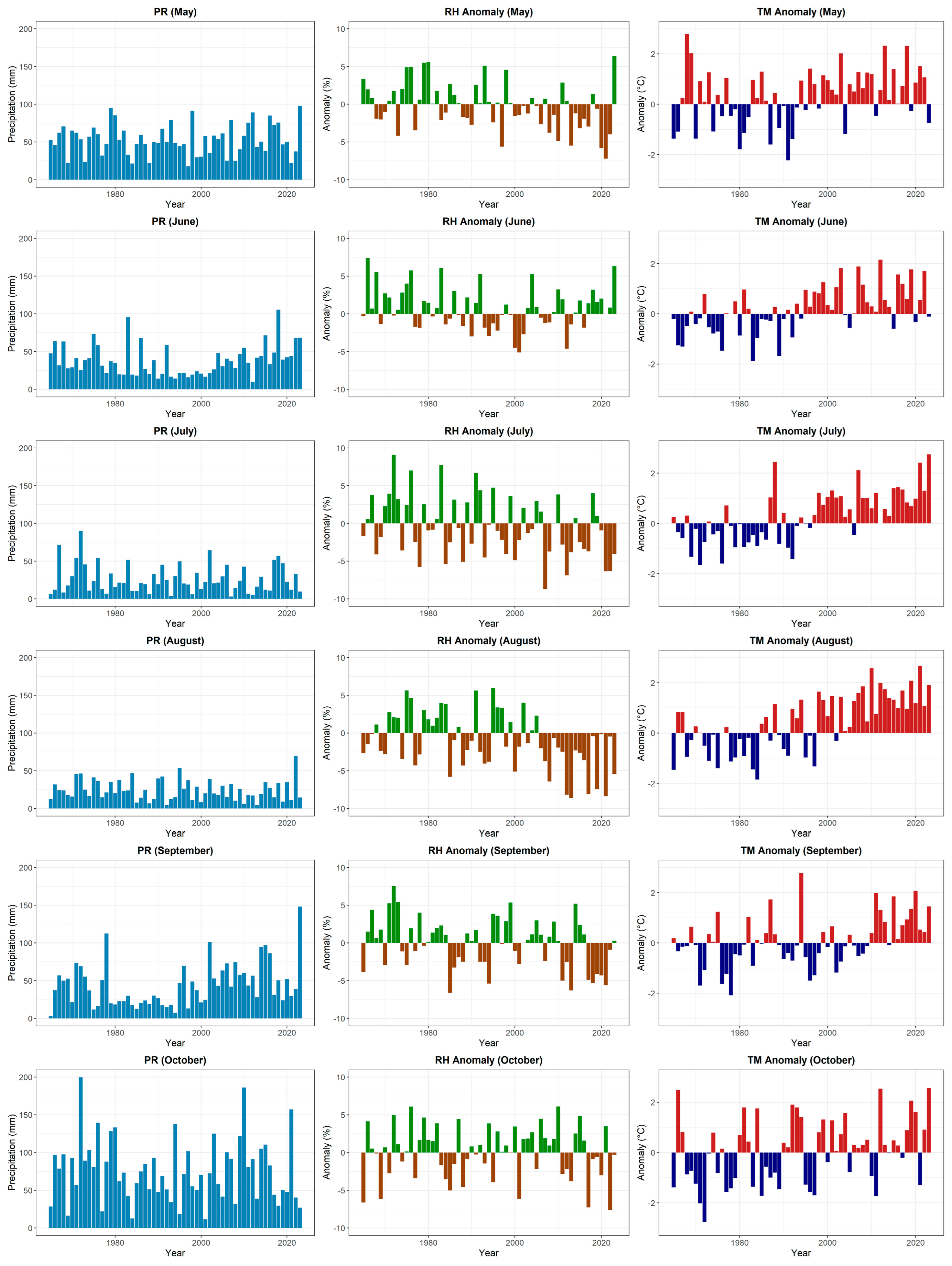
To examine seasonal and interannual variability, monthly density maps of precipitation, relative humidity, and temperature were generated for Greece over the period 1965–2023. A density map is a graphical representation in which individual values are illustrated using color gradients.
Figure 1 displays monthly density maps of precipitation (PR), relative humidity (RH), and mean air temperature (TM) across Greece for the extended warm season (May–October) during the period 1965–2023. Each row corresponds to a year, and each column to a month. The color intensity indicates the magnitude of each variable, revealing seasonal patterns and enabling visual interpretation of interannual variability and long-term trends. These climatological patterns form the basis for interpreting shifts in fire weather conditions and assessing changes in fire risk.
The PR panel (left) shows generally low precipitation during the summer months, with sporadic high-precipitation events in years such as 1972, 1983, 2018, and 2022. Notably, several Septembers since 2000 have recorded increased rainfall. The RH panel (middle) indicates a gradual decline in relative humidity, particularly during July and August in recent decades, as reflected by the increasing prevalence of brown shades. In contrast, the TM panel (right) clearly highlights a sustained warming trend across all months, especially pronounced from the mid-1980s onward. The intensification of red shades in the core summer months (July–August) underscores the rise in seasonal temperatures. Together, these patterns reflect a consistent shift toward hotter and drier summer conditions, with potential implications for drought frequency, heat stress, and fire weather risk across the studied region.
Additionally,
Figure 2 presents precipitation totals (PR), relative humidity anomalies (RH), and temperature anomalies (TM) for the months of May to October over the period 1965–2023, with anomalies calculated relative to the 1981–2000 baseline. Precipitation in Greece exhibits substantial interannual variability without a consistent long-term trend. July and August typically receive less precipitation than May, September, and October. Nevertheless, several months have experienced extreme rainfall events. In August 2022, intense rainfall and storms led to localized flooding. In October 2021, two successive storm systems—Storm Athina and Storm Ballos—resulted in significantly increased rainfall. More recently, in September 2023, extreme precipitation associated with Storm Daniel, a Mediterranean tropical-like cyclone, caused severe impacts across central Greece.
A clear drying trend is evident in July and August, marked by frequent below-average RH and increasing temperature anomalies, particularly from the mid-1990s onward. RH anomalies show a persistent negative shift during the core fire season (July–September), reinforcing the signal of a drier and warmer environment. Temperature anomalies display a pronounced upward trend, especially during the summer months, indicating more frequent and intense heat conditions. These findings highlight a climatological shift toward hotter and drier summers in Greece, particularly in July and August, indicative of increasingly favorable conditions for fire development.
3.2. Evaluation of the Historical FWI Data
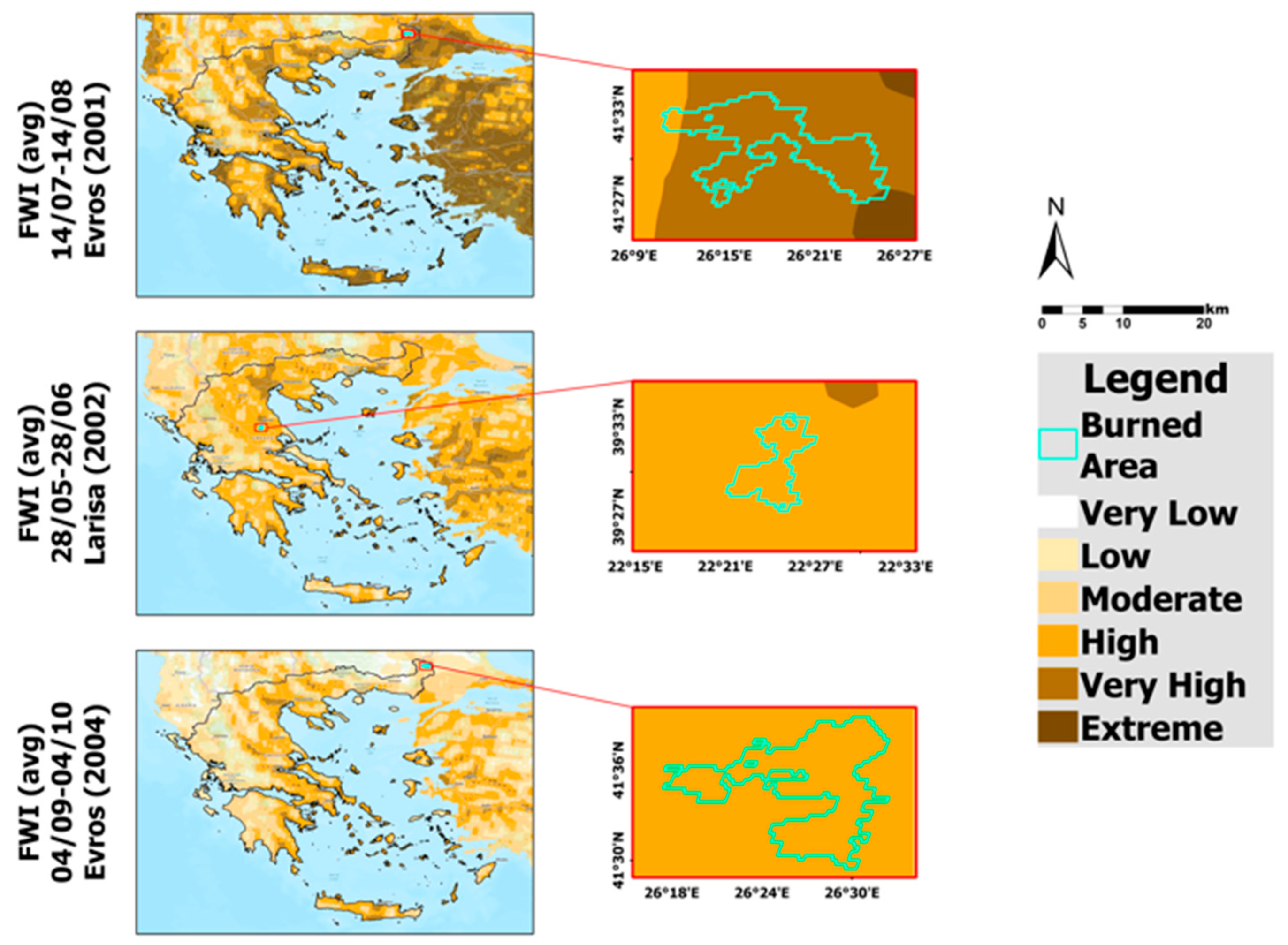
Subsequently, this study proceeded with an evaluation of the data obtained from the Copernicus Climate Change Service (C3S) platform, focusing on three major wildfire events in Greece. The aim was to assess whether the FWI values one month prior to each event could serve as a signal. These events included two forest fires in the Evros region (northeastern Greece) on 15 August 2001 and 5 October 2004, and a wildfire in Larisa (central Greece) on 29 June 2002. The investigation compared the occurrences of these fires with the average FWI for the month preceding each event, with the results presented in
Figure 3.
The findings indicate that, for all three wildfire events, the FWI provided a reliable forecast. The top map in
Figure 3 illustrates the average FWI values across Greece from 14 July to 14 August 2001. A wildfire occurred in Evros on 15 August 2001, where the preceding month’s average FWI values indicated a “very high” probability of wildfire occurrence. In the 2002 case study, which involved a wildfire in Larisa (middle map in
Figure 3), the index suggested a “high” probability. Similarly, for the wildfire in early October 2004 in Evros, the index also indicated a “high” probability of fire occurrence.
This analysis highlights the significance of the Fire Weather Index as a predictive tool for assessing wildfire risk. However, it also emphasizes the need for complementary approaches that account for additional factors, such as local wind variability, vegetation density, and human activities.
3.3. Fire Risk Assessment
3.3.1. Fire Risk Assessment for Present and Future 30-Year Periods
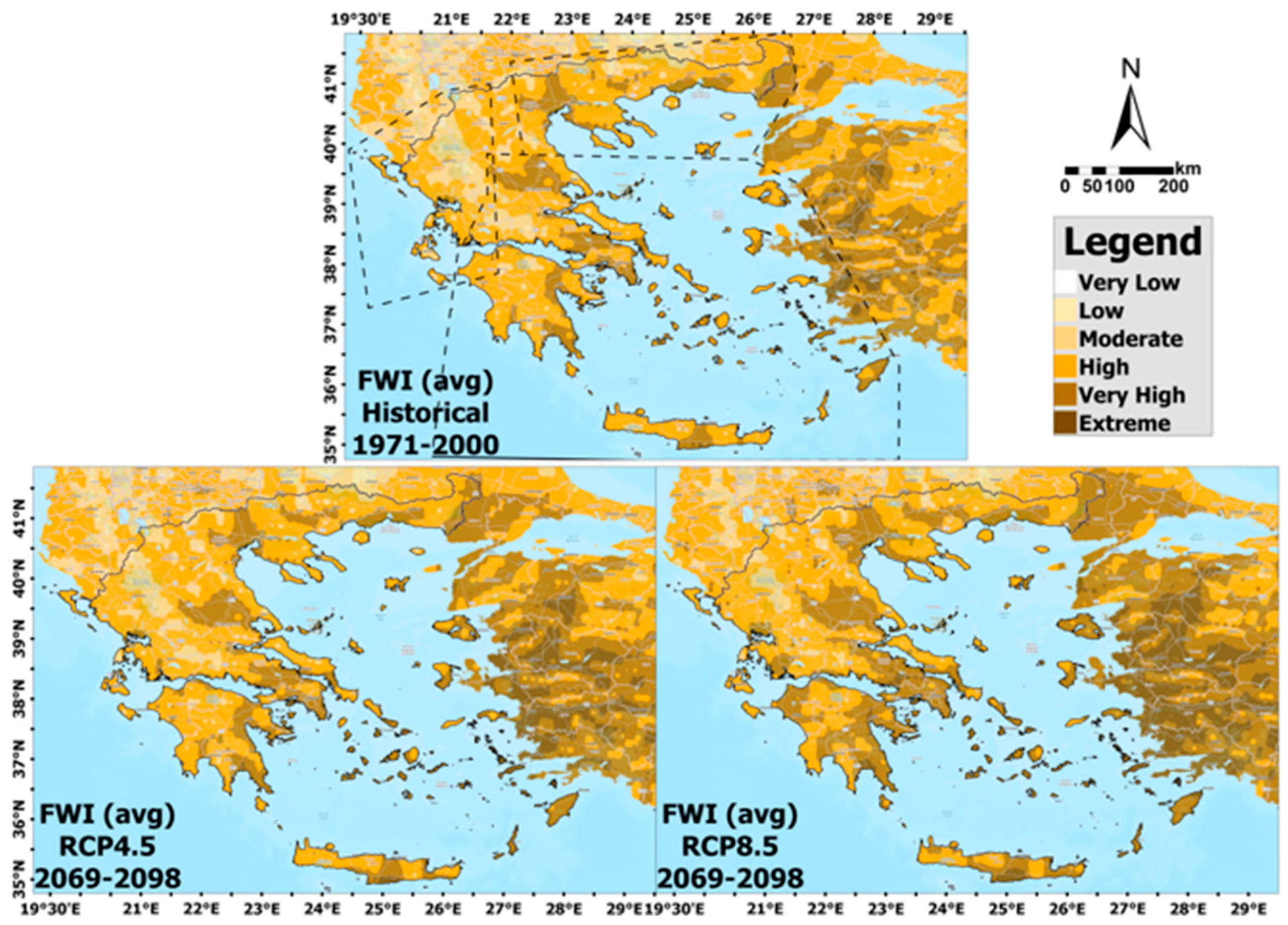
To assess wildfire risk in Greece, the average Fire Weather Index (FWI) values for the fire season (May–October) were analyzed. This assessment includes both historical data from the 30-year period 1971–2000 and projections based on the RCP4.5 and RCP8.5 scenarios for the 30-year period 2069–2098 (
Figure 4). The results reveal a marked upward trend in fire weather risk, particularly under the high-emission RCP8.5 scenario, indicating an increasing likelihood of extreme fire conditions in Greece in the latter part of the 21st century.
During the historical period, FWI values across Greece ranged from “low” to “very high”. Higher fire weather risk was typically observed in lowland and coastal areas, particularly in parts of central Macedonia (northern Greece), Thessaly (central Greece), the eastern parts of the southern mainland (e.g., Attica, eastern Peloponnese), and larger islands (e.g., parts of Crete and Rhodes), regions that are also projected to face increased risk in the future. A similar spatial pattern is anticipated going forward, although some areas are expected to see an expansion in fire risk. In both future scenarios, several regions—especially in the south—are projected to reach “very high” risk levels, with some facing “extreme” danger under RCP8.5. These high-risk areas are identified in eastern Thrace, central Macedonia, Thessaly, eastern Peloponnese, and several large islands such as Crete and Rhodes, which host significant forested landscapes.
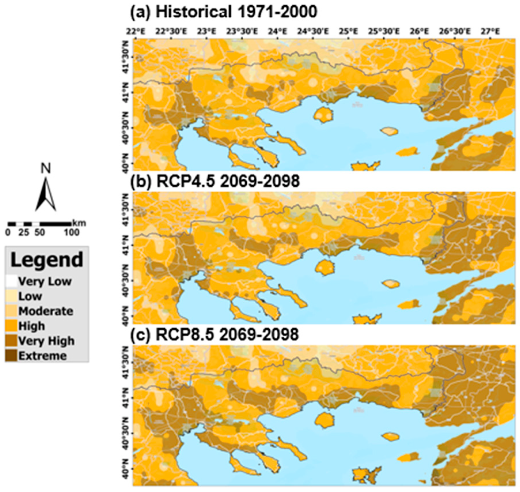
While future fire risk maps resemble those of the historical period, they indicate a general intensification of danger. Under RCP4.5, increased fire risk is expected in the Aegean islands and parts of northern Greece. Under RCP8.5, a broader expansion into higher fire danger categories—from “high” to “extreme”—is projected, likely due to the anticipated spread of arid climate conditions in the northern Mediterranean by the late 21st century. To facilitate a more detailed assessment of spatial variation, the analysis was initially conducted at the national level across Greece. Subsequently, the study area was subdivided into three geographical subregions—western, northeastern, and southern Greece—to allow for a more focused regional analysis. The boundaries of these subregions are indicated by dashed lines in the top map of
Figure 4. This hierarchical approach enables a clearer understanding of broad national trends, while also highlighting specific regional patterns and areas of heightened vulnerability.
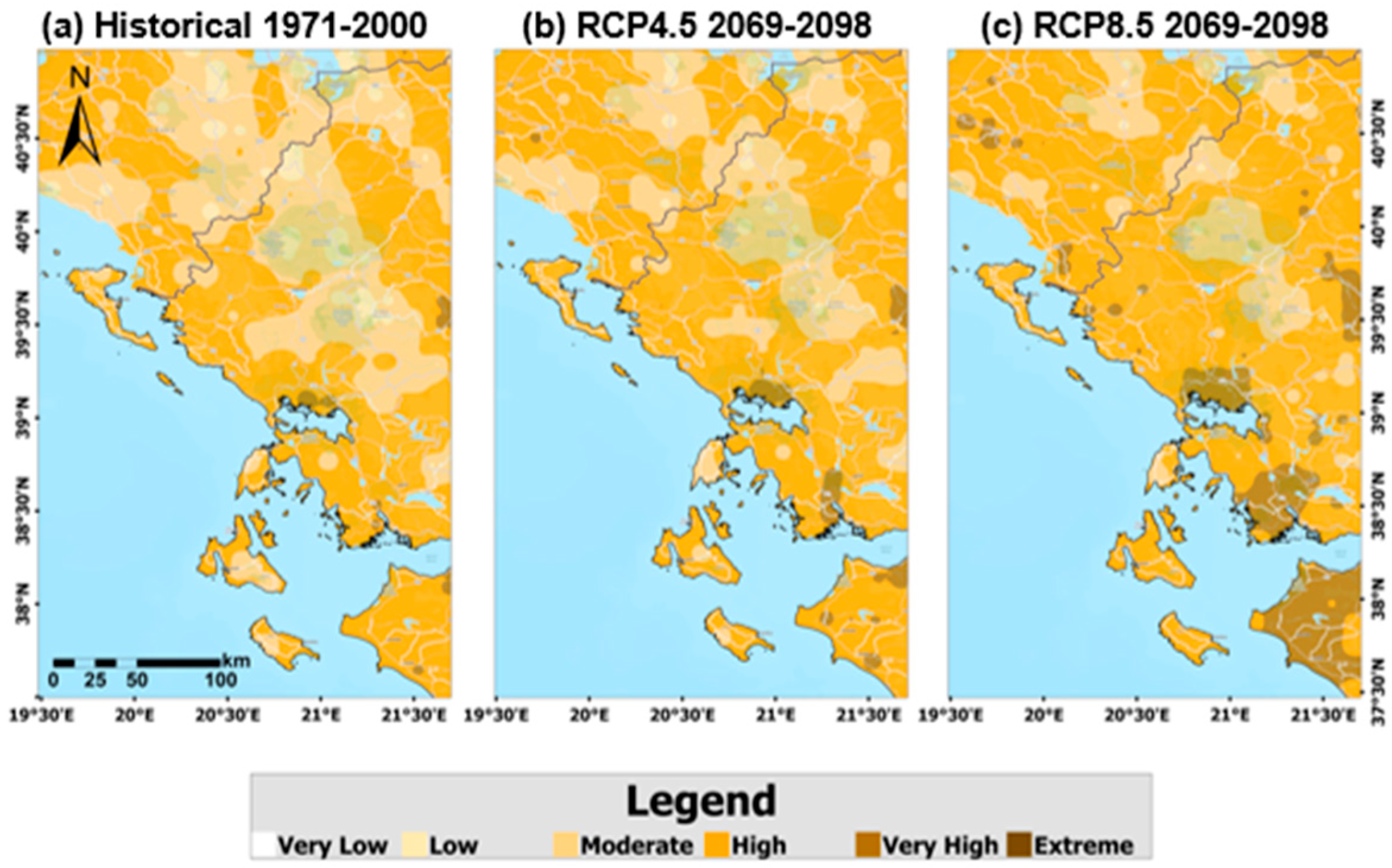
More specifically, among the three subregions, the impact of climate change on fire risk is least pronounced in western Greece under both scenarios, particularly in the regions of Epirus, Western Macedonia, and the Ionian Islands. In these areas, the FWI exhibits minimal changes compared to the historical period (1971–2000) (
Figure 5). It is important to note that western Greece, especially Epirus and the Ionian Islands, is characterized by a wetter climate relative to other parts of the country. This region receives higher annual rainfall, influenced by its mountainous terrain and proximity to the Ionian Sea. These climatic conditions mitigate fire risk, as western Greece undergoes fewer significant changes, leading to a lower probability of extreme fire events. In this region, fire risk generally increases from the “low” to the “moderate” category, with localized higher probabilities of fire occurrence observed primarily under the RCP8.5 scenario in limited areas.
Regarding the regions of central and eastern Macedonia and Thrace, these areas appear to be affected to some extent, particularly under the RCP8.5 scenario, with an increase in regions transitioning in the fire risk index from “high” to “very high” and, in some cases, to “extreme.” Notably, in the areas of the central part of the region of Macedonia in northern Greece, as well as along the eastern border of Macedonia with western Thrace, and in the far eastern end of the country, the Evros region, the fire risk is increased (
Figure 6). This increase in fire risk is particularly significant in the Evros region, which is characterized by a variety of vegetation types, including forests and agricultural lands that can serve as fuel for wildfires. Dense forests, especially in the mountainous areas, further elevate the vulnerability to fire. A characteristic example of this vulnerability is the severe “Evros fire” of 2023, one of the largest wildfires in the EU. This fire burned approximately 90,000 ha [
53], affecting over 50% of the Dadia National Park, a region renowned for its rich biodiversity and as a habitat for various bird species.
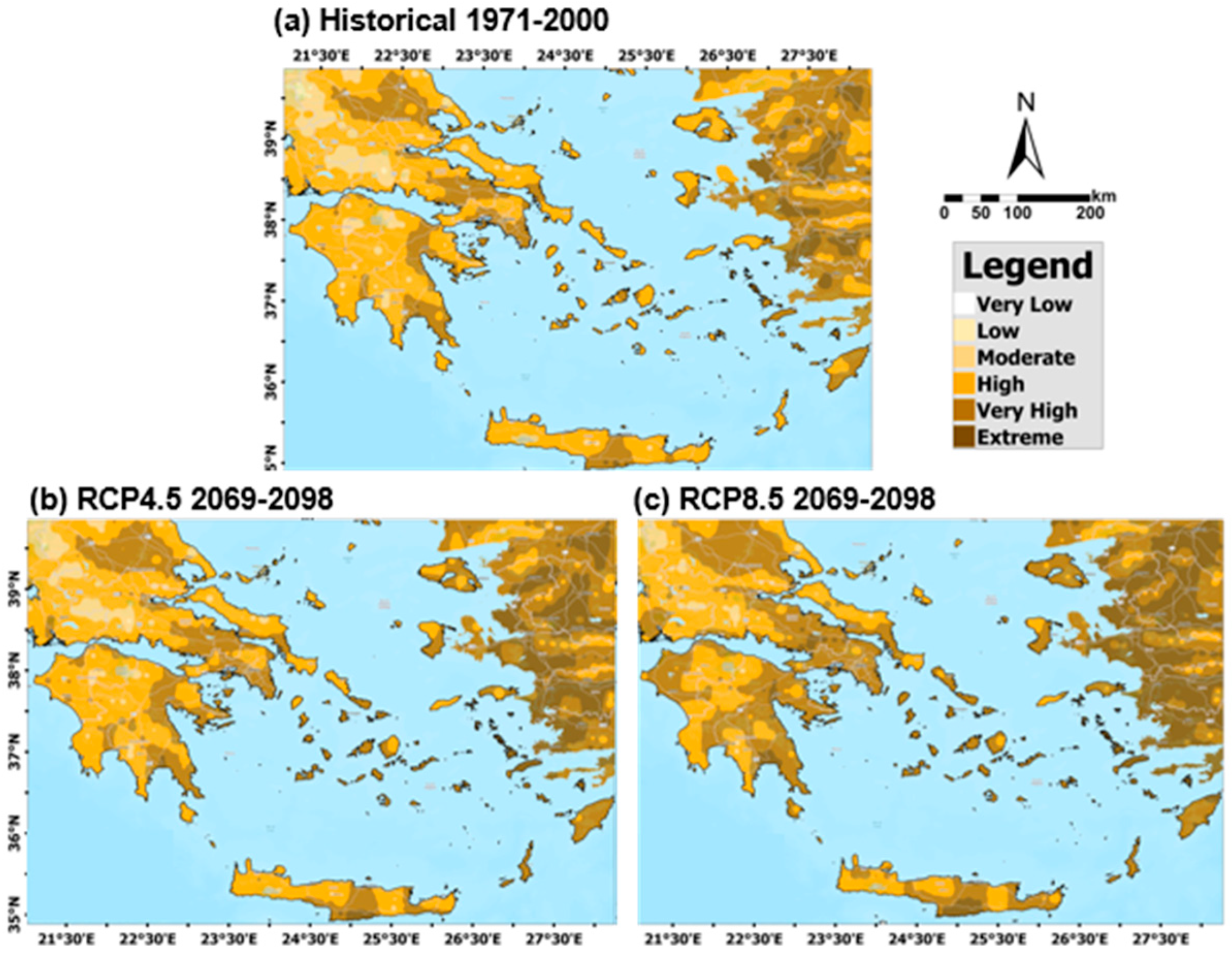
Finally, substantial shifts toward higher fire risk classes (“very high” and “extreme”) are observed in several regions, including the Peloponnese, Central Greece (particularly Attica), Thessaly, Crete, the Cyclades, the Northern Aegean Islands, and the Dodecanese, especially under the RCP8.5 scenario. Conditions in southeastern Peloponnese and the islands of Rhodes, Lesvos, and Chios appear particularly critical for the 30-year period from 2069 to 2098, with very high and even extreme probabilities of fire occurrence throughout the entire fire season (
Figure 7). The increasing fire risk in these areas could have severe consequences for tourism, a key industry in some of these regions. For example, the recent devastating wildfire on Rhodes in 2023 caused widespread damage to landscapes, disrupted local communities, and led to significant losses in tourist arrivals. The island saw mass cancellations of flights, and some tour operators cancelled flights until August. Such events highlight the potential economic and social impacts of rising fire risks, threatening not only the environment but also the livelihoods of those dependent on tourism.
Statistical analysis using a normal distribution provides an illustrative view of projected changes in fire risk distribution, as shown in
Figure 8. The lower fire risk categories (“moderate”, “low”, and “very low”) decline significantly in both future scenarios compared to the historical period (1971–2000), indicating a reduction in areas with minimal fire risk. Similarly, the “high” fire risk class decreases from 47% in the historical period to 43% under RCP4.5 and 36% under RCP8.5. In contrast, the most severe fire risk categories increase considerably. The “very high” fire risk class rises from 24% historically to 31% under RCP4.5 and 37% under RCP8.5, while the “extreme” fire risk class rises sharply from 4% to 11% and 16% under RCP4.5 and RCP8.5, respectively. This redistribution indicates a clear shift from lower to higher fire risk categories, particularly in southern and central Greece, driven by rising temperatures and intensified drought conditions associated with climate change.
Although mountainous and coastal areas exhibit smaller changes, the overall trend indicates a growing prevalence of severe fire conditions. It should be noted, however, that the analysis assumes normally distributed data. In coastally influenced regions, where skewed distributions can occur, actual shifts may be more pronounced than those shown here. Despite this limitation, the results provide a useful approximation of changing fire regimes under future climate scenarios, with an increasing proportion of Greek territory exposed to high and extreme fire risks.
3.3.2. Fire Risk Assessment for Present and Future 10-Year Periods
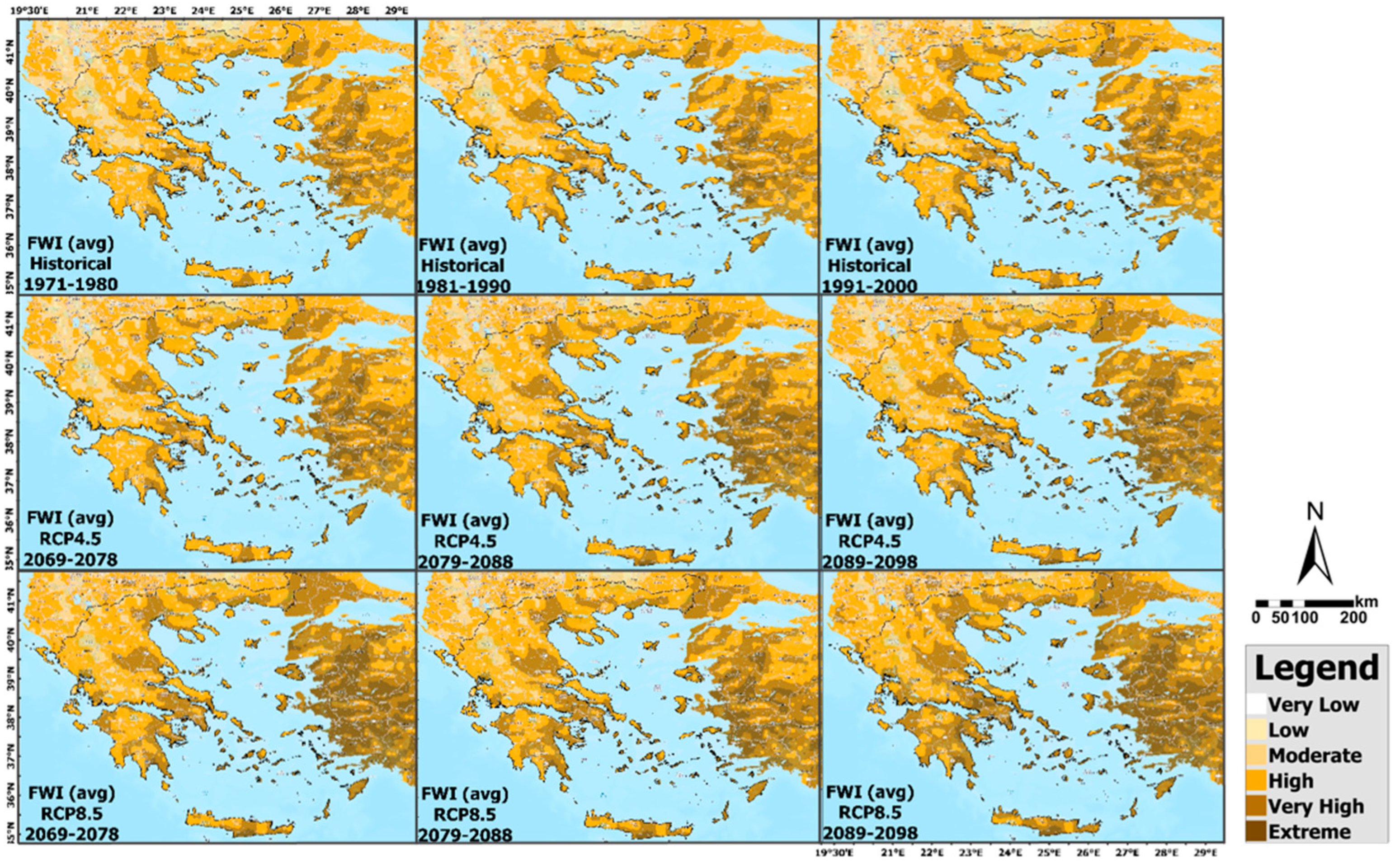
In addition, average Fire Weather Index values across Greece were analyzed per decade for both the historical period (1971–1980, 1981–1990, 1991–2000) and future projections (2069–2078, 2079–2088, 2089–2098) (
Figure 9). Overall, the decade-wise analysis indicates relatively minor variations, with some notable exceptions. Among the historical data, the period 1991–2000 exhibited the highest fire risk levels, particularly in continental regions such as Thessaly, Attica, and central Macedonia. This increase may be attributed to intensified industrialization, agricultural expansion, and land-use changes over the last two decades of the historical era.
Under the RCP4.5 scenario, the decade 2089–2098 emerges as the most critical in terms of fire risk. This period is particularly concerning for southern Greece, especially the Dodecanese, where high, very high, and extreme fire probabilities are projected across all islands throughout the fire season. Compared to the historical period, the Northern Aegean Islands exhibit an increased fire risk, while in Central Macedonia (specifically Pieria, Imathia, and Pella), the spatial extent of areas classified as “high” and “very high” fire risk increases in 2079–2088 relative to 2069–2078.
Under the RCP8.5 scenario, the period 2089–2098 again presents the highest wildfire probabilities during the fire season. Central continental areas, particularly Thessaly, Attica, and the Peloponnese, exhibit significantly increased fire risk compared to historical conditions. Notably, large parts of the eastern Aegean islands, such as Lesbos, Samos, and Rhodes, are projected to experience very high and extreme fire risk across much of the future 30-year period, with peak intensities observed in the first and third decades.
3.3.3. Assessing the Extension of the Fire Season: Projections for April and November
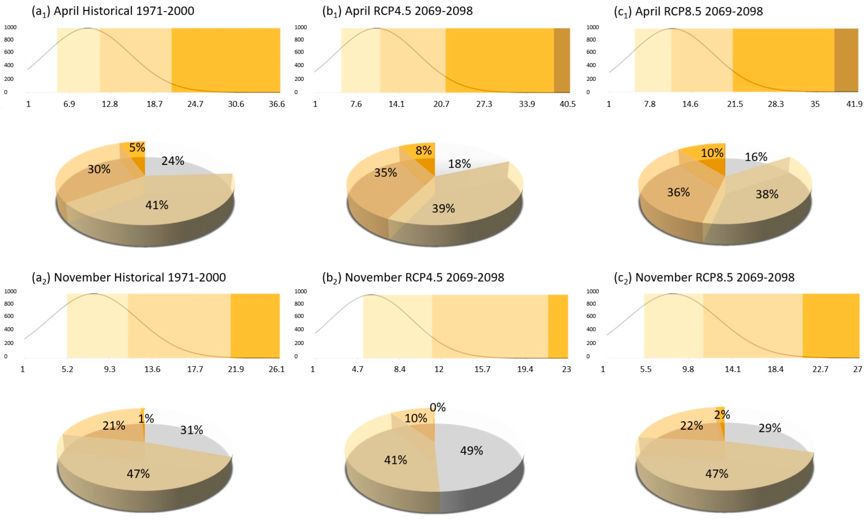
Changes in fire risk during April and November for the period 2069–2098 were assessed under two emissions scenarios. A statistical comparison based on normal distribution analysis was conducted to evaluate differences between historical conditions and future projections (
Figure 10). The results indicate that, during the reference period, there were no recorded instances of “high”, “very high”, or “extreme” fire danger levels in either month. Most Fire Weather Index values fell within the “moderate” category, representing 41% in April and 47% in November.
In April, both the RCP4.5 and RCP8.5 scenarios show a decrease in the proportion of the “very low” and “low” fire probability classes, accompanied by an increase in the “moderate” and “high” classes relative to historical data. Additionally, small proportions of the “very high” and “extreme” categories emerge, indicating a potential early season escalation in fire risk. In contrast, November projections do not exhibit a notable shift toward higher fire danger in either scenario. Most values remain within the “moderate”, “low”, and “very low” FWI classes, suggesting limited change in fire risk during this late-season month.
4. Discussion
Long-term climatic trends across Greece reveal a steady shift toward hotter and drier summer conditions, especially during July and August, as evidenced by rising temperature anomalies and persistently low relative humidity over the 1965–2023 period. These changes enhance fuel dryness and ignition potential, aligning seasonal climatic patterns with conditions favorable for wildfire development. Although precipitation remains highly variable without a clear trend, the decline in relative humidity and rise in temperature from the mid-1990s onward emphasize growing fire risk.
The Mediterranean climate, characterized by hot, dry summers and xerophytic vegetation, combined with climate change, exacerbates fire susceptibility in Greece. The Aegean islands, already facing challenges due to summer droughts, are expected to come under increasing pressure from rising temperatures, posing significant threats to regional biodiversity. Beyond ecological degradation, wildfires are likely to have severe economic and social repercussions. Greece’s economy, heavily dependent on tourism and agriculture, is particularly vulnerable. Many high-risk areas—including the North Aegean Islands, the Cyclades, and the Dodecanese—are major tourist destinations. Wildfires will not only degrade natural landscapes and damage infrastructure but also increase atmospheric pollution and hinder sustainable tourism development. Agricultural production, especially in Crete where olives and vines are critical economic crops, will also be affected. Soil degradation and crop loss from fire events are expected to further exacerbate economic vulnerability.
Addressing future wildfire risks requires a multi-faceted approach emphasizing prevention, preparedness, technological advancements, and long-term adaptation. While current efforts focus largely on fire control and suppression, future strategies must place equal emphasis on adaptation, particularly in fire-prone and climate-sensitive regions. This includes integrated land-use planning, promotion of climate-resilient agriculture, and investment in early warning systems and community resilience. Prevention remains key, as human activity is the primary cause of ignitions; enforcing stricter regulations during high-risk periods and conducting targeted public awareness campaigns can significantly reduce human-induced fires. Education and consistent application of preventive measures are essential for minimizing ignition sources and encouraging responsible behavior.
This study indicates a projected rise in wildfire likelihood as early as April in future decades, highlighting the need to reconsider and potentially extend the official fire season. Extending the season would enhance preparedness and ensure prevention efforts align with shifting fire risk patterns. This analysis relies on widely used FWI data, which may not fully capture local climatic variability, especially in precipitation and temperature extremes. Additionally, it does not account for important factors such as land use, human ignitions, and socioeconomic influences, which are critical drivers of wildfire risk. Future research should incorporate models that cover a broader temperature–precipitation range and integrate these non-climatic variables to provide more comprehensive fire risk assessments across diverse Greek landscapes. Adapting fire management policies accordingly is crucial to protect Greece’s forest ecosystems under future climate scenarios.
Key forest management practices—such as firebreaks, vegetation clearance, and continuous monitoring—are vital for limiting fire spread and intensity. Post-fire restoration efforts, including reforestation and soil conservation, support ecosystem recovery. Additionally, technological tools like GIS, AI, and satellite monitoring enhance fire forecasting, early warning, and community engagement, enabling more adaptive wildfire management.


