- Article

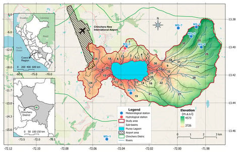
Understanding the Impacts of Climate Change and Landcover/Land Use Transformations on Highlands Hydrological Ecosystem Services in the Piuray–Ccorimarca Watershed (Andean Cordillera of Peru)
- Cristian Montesinos,
- Danny Saavedra and
- Waldo Lavado-Casimiro
- + 3 authors
Watersheds provide fundamental hydrological ecosystem services for human well-being and the environment, such as water provisioning, hydrological cycle regulation, and erosion control; however, these services face increasing anthropogenic and climatic pressures. This study assessed individual and combined impacts on the hydrological functionality of the Piuray–Ccorimarca watershed (Cusco, Peru) using a calibrated Soil and Water Assessment Tool (SWAT) model, analyzing water yield, soil water storage, and sediment transport across 20 scenarios. An ensemble of 10 Coupled Model Intercomparison Project Phase 6 (CMIP6) models with bias correction was implemented, integrated with land transformation projections contemplating urban expansion associated with airport development and forest recovery through Payment for Ecosystem Services mechanisms. The results reveal climate change as the dominant driver, generating water yield increases and soil water content improvements primarily due to evapotranspiration decoupling that increases the runoff coefficient. In contrast, land use change produces substantially smaller hydrological effects but critically intensifies sediment yield. Spatial vulnerability analysis identified eight persistently critical sub-basins (20.5% of area) where soil water content emerged as the dominant limiting factor. These findings establish a clear management hierarchy prioritizing climate adaptation over land use interventions, with differentiated strategies required for critical zones demanding structural interventions versus non-critical areas amenable to flexible conservation approaches.
6 February 2026