


GeoHazards 2026, 7(1), 9; https://doi.org/10.3390/geohazards7010009 - 6 Jan 2026
Abstract
►
Show Figures
The optimization of seismic isolation parameters is essential for balancing displacement demand and acceleration control in base-isolated structures. While numerous studies have applied metaheuristic algorithms to isolator tuning, the influence of objective-function weighting on optimal design outcomes remains insufficiently explored. This study investigates
[...] Read more.
The optimization of seismic isolation parameters is essential for balancing displacement demand and acceleration control in base-isolated structures. While numerous studies have applied metaheuristic algorithms to isolator tuning, the influence of objective-function weighting on optimal design outcomes remains insufficiently explored. This study investigates the effects of displacement and acceleration on control performance in a multi-objective optimization function. Thus, acceleration can be reduced economically by limiting the isolator displacement capacity. In the study, the effective values of the acceleration and displacement coefficients in the objective function of the problem are changed for the design optimization of seismic base isolators, and the determination of the most appropriate weights in the equation and their effects on the control are investigated. In the optimization process, the adaptive harmony search algorithm, which is obtained by adapting the parameters of the harmony search algorithm inspired by the search for the best harmony, is used. The results demonstrate that increased emphasis on acceleration minimization leads to longer effective isolation periods and higher damping ratios, whereas displacement-dominated weighting results in stiffer isolation systems with reduced mobility.
Full article
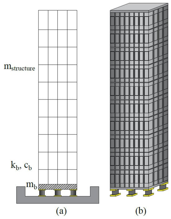
Figure 1


