Abstract
The Late Holocene flood history of the Cauvery River floodplain in the Poompuhar region was reconstructed using a multiproxy sedimentological approach applied to three trench cores. Lithostratigraphy, loss on ignition (LOI), magnetic susceptibility (MS), sand–silt–clay textural analysis, granulometric statistics (Folk and Ward), Passega CM diagrams, and grain angularity provide complementary evidence to differentiate high-energy flood deposits from background slackwater sediments. Grain-size processing and statistical analyses were carried out in R using the G2Sd package, ensuring reproducible quantification of mean size, sorting, skewness, kurtosis, and transport signatures. We identified 10 discrete high-energy event beds. These layers are characterised by >80% sand content, low LOI (<3.5%), and low frequency-dependent MS (χfd% < 2%), confirming rapid, mineral-dominated deposition. A tentative chronology, projected from the regional aggradation rate, suggests two major flood clusters: a maximum-magnitude event at ~3.2 ka and a synchronous cluster at ~1.6–1.8 ka. These events chronologically align with the documented phases of channel avulsion in the adjacent Palar River Basin, supporting the existence of a synchronised Late Holocene climato-tectonic regime across coastal Tamil Nadu. This hydrological evidence supports the hypothesis that recurrent high-magnitude flooding triggered catastrophic channel avulsion of the Cauvery distributary, leading to the fluvial abandonment and decline of the ancient port city of Poompuhar. Securing an absolute chronology requires advanced K-feldspar post-IR IRSL dating to overcome quartz saturation issues in fluvial deposits.
1. Introduction
Paleoflood research extends flood records far beyond the short instrumental period, providing insights into the recurrence, magnitude, and forcing mechanisms of extreme events over millennial timescales [1,2,3]. Such records reveal natural climate variability and illuminate the role of floods in human migration, settlement abandonment, and sociocultural transitions [4].
Reconstructing past floods requires a multiproxy framework that integrates sedimentology, geomorphology, geochemistry, and geochronology. Sedimentological indicators, such as grain size distribution, organic matter content, and magnetic susceptibility, are widely applied to identify high-energy flood deposits, while radiocarbon and optically stimulated luminescence (OSL) dating establish robust chronologies [5,6]. Geochemical techniques, including X-ray fluorescence (XRF) and X-ray diffraction (XRD), further discriminate event layers from background sedimentation [7]. When coupled with archaeological and historical archives, these approaches enable the reconstruction of flood frequency, magnitude, and associated environmental and cultural consequences [8].
In South Asia, although extensive paleoflood studies have been conducted on the Ganga, Brahmaputra, and Indus systems, peninsular river basins remain comparatively understudied, leading to a significant regional knowledge gap. Research in this region over the past decade has been geographically fragmented, successfully establishing OSL chronologies for slackwater deposits in the upper Kaveri Basin [9,10] and linking extreme Holocene hydrological events to channel avulsion and habitation patterns in ephemeral systems such as the Vaigai and Penner Rivers [11,12,13,14]. Furthermore, studies on rivers such as the Palar have focused on Holocene migration and provenance [15,16], and work on the wider Cauvery Delta has centred on using OSL to infer sea-level fluctuations [17,18]. Despite these essential regional advances, a systematic, continuous, multi-proxy paleoflood record focused specifically on the lower reaches and deltaic sediments of the Cauvery River, the precise zone where fluvial processes influenced the cultural landscape of ancient Poompuhar, remains absent, limiting our ability to fully integrate long-term flood hazards into paleoenvironmental reconstruction. Compounding this, the east coast of Tamil Nadu contains several ancient coastal cities that are hypothesised to have been submerged; however, the submergence mechanism remains unclear. While worldwide studies demonstrate that high-magnitude floods can be a dominant factor in the sudden abandonment and submergence of coastal settlements [2,7,19], this perspective has not been rigorously applied to Poompuhar, a significant port city known to have been submerged by floods. Epigraphical evidence further highlights the destructive potential of the Cauvery flood regime [20]. Thus, reconstructing the paleoflood history in this sensitive lower-delta region is critical for addressing both scientific and archaeological questions.
The lower Cauvery is also historically linked to the ancient port city of Poompuhar (Kaveripoompattinam), a Sangam-era maritime hub located at the river mouth [21]. Archaeological and textual evidence suggest that the city was repeatedly impacted by floods, coastal erosion, and sea-level fluctuations [22,23]. While marine transgressions and tectonic activity are often emphasised as drivers of its decline, recent studies indicate that catastrophic fluvial events may have played an equally critical role [10,13,20,24]. Despite this recognition, sediment-based paleoflood reconstructions from the Cauvery Delta are virtually absent.
To ensure rigorous and reproducible event-bed identification, a set of three diagnostic multi-proxy thresholds was established a priori, differentiating flood deposits from background slackwater sedimentation. Specifically, an event layer had to simultaneously meet three strict criteria: (1) a sand fraction greater than 80%, indicating high-energy flow; (2) a loss-on-ignition (LOI) value less than 3.5%, signifying low organic content characteristic of rapid, mineral-dominated deposition; (3) a low frequency-dependent magnetic susceptibility (Xfd % < 2%), confirming minimal fine-grained magnetic mineral contribution and short deposition time. These three thresholds were treated as equally weighted diagnostic filters for initial event identification, with further multiproxy analysis (for example, through CM diagrams and grain angularity) used for detailed transport process interpretation in the Results and Discussion Sections.
This study addresses a gap by identifying and characterising paleoflood deposits from three sediment cores collected from the Poompuhar region. A suite of sedimentological and geophysical analyses, including those using litho-logging, textural (sand–silt–clay) analysis, loss on ignition (LOI), magnetic susceptibility (MS), granulometric statistics (Folk and Ward method), CM pattern interpretation, and grain angularity, were applied to distinguish flood-event layers from background slackwater sedimentation. Grain size distributions were quantified using the G2Sd package in R, and the angularity data provided insights into sediment provenance and transport energy. By integrating these proxies, this study reconstructs features of the Cauvery’s Late Holocene flood history and explores their linkages to monsoon variability and the cultural route of Poompuhar. The results extend the paleoflood record for peninsular India, provide a sedimentary framework for future chronological dating, and contribute to contemporary flood risk assessment and geoarchaeological heritage preservation in the Cauvery Delta.
2. Study Area
The Cauvery Delta in Tamil Nadu is underlain by an Archean–Proterozoic crystalline basement and is overlain by extensive Quaternary alluvium deposited through repeated flood events and channel migrations. Poompuhar, an ancient port city at the river’s mouth, lies just one metre above the mean sea level and has historically been influenced by large floods and channel shifts in the Cauvery River. The deltaic plain is characterised by floodplains, basins, point bars, channel bars, paleochannels, and sand ridges, reflecting the imprint of past high-magnitude floods and fluvial reworking events. Prominent paleochannels identified in the region are approximately 400 m wide, marking abandoned river courses that once transported significant discharges during flood episodes [20,21,25]. These paleochannels, along with the associated floodplain deposits, serve as important archives for reconstructing the history of extreme floods in the lower Cauvery. In this study, sediment samples were collected from three floodplain locations to capture the lithological variability and textural indicators of past flood deposition. These sites provide critical evidence for identifying flood sequences and paleoflood stratigraphy within the deltas. Figure 1 shows the study area with sampling sites and key geomorphological features relevant to the paleoflood reconstruction.
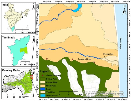
Figure 1.
Study area showing geomorphological landforms and sampling sites in the Poompuhar region. The colors in left figure are used to differentiate the regions.
3. Methodology
Figure 2 shows a flowchart of the methodology. High-resolution Sentinel-2 imagery from the USGS Earth Explorer was processed in ArcGIS 10.3.1 using FCC, TCT, USC, and NDVI enhancements to improve landform recognition [20]. The derived geomorphological map guided the selection of three flood-prone sites in the Poompuhar region for sediment coring. Trenches (2.1–3.12 m) were excavated, lithologically logged, and subsampled in the field itself.
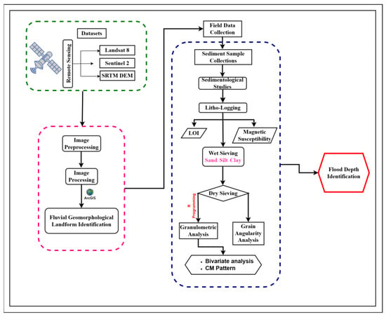
Figure 2.
Methodology flowchart.
Loss on ignition (LOI) was used to determine the sequential loss of organic matter and carbonate. Sediment samples, with an initial dry mass of 10 g, were first oven-dried at 105 °C for 12 h to determine the water content. The samples were then transferred to a muffle furnace, and the temperature was increased slowly (approximately 10 °C/min) between stages [26,27]. The organic matter content was determined by combustion at 550 °C for a duration of 5 h. The carbonate content (CaCO) was subsequently determined by combustion at 950 °C for a duration of 2 h.
Magnetic susceptibility (χ) measurements were performed using 10 g sediment samples and a Bartington MS2 instrument with a 10cc sample loop [4]. Two frequencies were utilised: a low frequency (χlf) of 0.465 Hz and high frequency (χhf) of 4.65 Hz [28]. For quality control and to minimise instrument noise, each sample was measured three times at both frequencies, and the average value was used for all the subsequent calculations [29]. The measurement uncertainty was maintained at less than 3%. The frequency-dependent magnetic susceptibility (χfd%) was calculated using Equation (1).
A key diagnostic threshold for identifying high-energy flood event layers was established a priori as χfd% < 2%, indicating a rapid deposition rate and minimal contribution from fine-grained magnetic minerals.
Grain size distributions were obtained using wet sieving and pipette analysis. Pretreatments removed carbonates (HCl) and organics (H2O2), and samples were dried at 80 °C before sieving at quarter-phi intervals (Folk and Ward, 1957) [30,31,32]. Data were analysed in R using the G2Sd package to calculate Mz, sorting, skewness, and kurtosis [30]. Transport processes were further interpreted using Passega’s CM diagrams [33] (Passega, 1957). Grain angularity was assessed using Wadell’s roundness method (1932) and cross-verified using Powers’ (1953) chart [31]. High proportions of angular grains reflect proximal, high-energy flood deposition, whereas rounded grains indicate reworking and longer transport distances [30,31].
This integrated sedimentological, geochemical, magnetic, and textural approach provided a robust framework for reconstructing paleoflood sequences in the Cauvery floodplain and linking hydrological variability to the environmental and archaeological history of Poompuhar [34].
4. Results
Three undisturbed sediment profiles were excavated from the study area with depths of 226 cm (L1—Location 1), 261 cm (L2—Location 2), and 311 cm (L3—Location 3) (Figure 3). From these profiles, 14, 15, and 17 undisturbed subsamples were obtained from Locations 1, 2, and 3, respectively, through direct in-field trench sampling. Lithological descriptions and texture-based observations were recorded for each subsample to characterise the depositional environment and identify potential flood-related layers in the sediment record. Figure 3 shows the profile graphs for all three locations.

Figure 3.
Field photographs of sample collection at (a) Location 1, (b) Location 2, and (c) Location 3 in and around the Poompuhar region.
4.1. Location 1
4.1.1. Lithostratigraphy
The stratigraphy at Location 1 revealed alternating fine- and coarse-grained units, reflecting shifts in flood energy (Figure 4). Homogeneous clay layers (Samples 1 and 4) indicated low-energy slackwater deposition, whereas poorly sorted clay–silt (Samples 2, 9, and 12) and clay–sand horizons (Samples 3, 8, and 11) recorded rapid deposition under fluctuating flow. Sample 8, with fine draping sand, represented waning flood stages, whereas the black clay with sand in Sample 13 reflected post-flood organic accumulation in the standing water. Silt with sand (Sample 7) suggested moderate-energy overbank discharge. Sand-dominated units (Samples 5, 6, 10, and 14) denoted high-energy floods: Sample 5 (fine sand with clay) captured recession flow, whereas the sharp-based coarse sands of Samples 6, 10, and 14 marked peak discharge or flash-flood events.
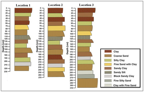
Figure 4.
Down-profile lithological variations at three sediment locations (1–3) in the Poompuhar region, showing depth-wise changes in composition.
4.1.2. Loss on Ignition
The LOI550 values ranged from 1.1 to 3.8%, with the maximum in Sample 13 (black clay with sand), reflecting organic-rich post-flood deposition. Clay-rich units (Samples 1, 2, 4, 9, and 12) showed elevated values (≥3.3%), consistent with low-energy floodplain settings. Coarse sand layers (Samples 6, 10, and 14) recorded the lowest values (1.1–1.3%), whereas mixed lithologies (Samples 3, 5, 7, 8, and 11) yielded intermediate values, marking transitional flood phases. The LOI950 ranged from 0.11 to 0.27, with the highest value in Sample 2 (clay with silt), corresponding to its maximum CaCO3 content (0.613%). Overall, CaCO3 varied between 0.25% and 0.613%, with higher concentrations in Samples 2, 4, and 9 and the lowest in coarse sand units (0.25–0.273%), reinforcing their interpretation as high-energy flood deposits.
4.1.3. Magnetic Susceptibility
The magnetic susceptibility (MS) at Location 1 showed clear variations, reflecting the depositional energy and pedogenic activity associated with past floods. Low-frequency (LF) values ranged from 1.7 to 42.17 × 10⁻⁸ m3/kg and high-frequency (HF) values from 1.67 to 35.83 × 10⁻⁸ m3/kg. The frequency-dependent susceptibility (χfd%), indicating ultrafine superparamagnetic grains formed during soil development, ranged from 0.19 to 35.26%. Elevated χfd% values in Samples 5 (25.81%), 9 (35.26%), 11 (17.26%), and 12 (32.93%) indicated low-energy, stable intervals corresponding to inter-flood soil formation. Low χfd% (<2%) in Samples 3, 6, 7, 8, 10, and 14 reflected high-energy flood deposits dominated by detrital magnetic minerals. Sample 9 showed a peak LF (42.17 × 10⁻⁸ m3/kg) and χfd% (35.26%), likely indicating prolonged surface exposure after a major flood. These patterns reveal alternating high-energy deposition and post-flood pedogenesis, confirming that magnetic susceptibility is a reliable proxy for reconstructing paleoflood sequences and fluvial stability in the Cauvery River floodplain.
4.1.4. Sand–Silt–Clay
Sediments at Location 1 were dominated by sand (35.7–94.3%), followed by silt (2.9–55.6%) and clay (1.2–8.7%). Sand-rich horizons (Samples 6, 8, 9, 10, and 11; ≥85%) reflected rapid deposition under high-energy flood conditions capable of transporting coarse particles, corresponding to the peak flood stages or channel-proximal settings. In contrast, horizons with higher silt and clay (Samples 5 and 7, with silt >50% and clay up to 9%) represented low-energy conditions during waning floods or inter-flood phases when fine particles settled from suspension. The alternation between sand-dominated and silt–clay-rich horizons indicates fluctuations in depositional energy, where sand layers mark high-magnitude floods and finer layers reflect lower-energy or post-flood sedimentation. When integrated with magnetic susceptibility and LOI, these textural patterns provide a robust record of paleoflood recurrence and fluvial processes in the floodplain.
The ternary plot clearly reflects the imprint of paleoflood dynamics in the Cauvery floodplain, with each core showing distinct textural fields linked to the depositional energy regimes. Location 1 (green) samples mainly fell within the sandy silt to silty sand fields, representing fine-grained deposition during waning flood stages and overbank flows (Figure 5). The dominance of silt-rich fractions indicates the repeated settling of suspended loads under moderate- to low-energy conditions, which is consistent with prolonged floodplain inundation.
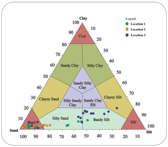
Figure 5.
Trilinear plot of sand–silt–clay percentages for Locations 1, 2, and 3.
4.1.5. Granulometric Analyses
Grain size statistics from the 14 layers at Location 1 revealed cyclic alternations between fine-grained suspension deposits and coarse-grained high-energy flood layers, reflecting repeated shifts in depositional energy (Figure 6; Table 1). The basal units, Samples 1 and 2 (very coarse silt, very poorly sorted, fine-skewed, platykurtic), indicated slackwater deposition under low-energy floodplain conditions. This trend continued in Samples 3 and 4 (very coarse silt with slightly improved sorting), suggesting transitional phases between overbank and channel environments. Sample 5 (coarse silt, very poorly sorted, fine-skewed) represented rapid overbank deposition with minimal sediment reworking. A marked energy increase was recorded in Sample 6 (coarse sand, poorly sorted, fine-skewed, leptokurtic), consistent with bedload transport during a high-energy flood. Sample 7 (fine sand, poorly sorted, very fine-skewed, and very leptokurtic) reflected moderate overbank flow, where both fine and poorly sorted sands were deposited simultaneously. Slackwater conditions returned in Sample 8 (coarse silt, very poorly sorted, fine-skewed, platykurtic), followed by renewed high-energy input in Sample 9 (medium sand, poorly sorted, very fine-skewed, very leptokurtic). The peak discharge was marked by Sample 10 (coarse sand, poorly sorted, fine-skewed, very leptokurtic), interpreted as a flash-flood layer. The subsequent waning phase was captured in Samples 11 (medium sand) and 12 (fine sand), both poorly sorted, fine-skewed, and leptokurtic. Sample 13, composed of well-sorted, symmetrical medium sand with a mesokurtic distribution, indicated a relatively uniform flow, possibly reworked channel deposits. The sequence culminated with Sample 14 (coarse sand, very poorly sorted, fine-skewed, very leptokurtic), a thick, high-energy bed linked to a major paleoflood. Collectively, these alternations between silt-rich horizons and thick coarse sand units demonstrate a dynamic flood regime, alternating between low-energy overbank or slackwater sedimentation and abrupt, high-energy paleoflood episodes within the Cauvery River system.
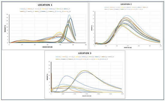
Figure 6.
Grain-size distribution curves (φ scale) for Locations 1, 2, and 3, showing the modes of deposition. The Y-axis represents the weight percentage of each grain-size class.

Table 1.
Textural parameters of sediments at Location 1.
Bivariate Grain Size
Bivariate grain size statistics from Location 1 provide key insights into the transport dynamics and depositional conditions (Figure 7). The mean grain size (ϕ) ranged from 0.886 to 5.276, ranging from coarse to fine sand. Coarser units (L1_6, L1_10, L1_14; ϕ < 1.5) reflected high-energy depositional events, whereas finer horizons (L1_1, L1_2, L1_5, L1_8; ϕ > 4) indicated low-energy slackwater settling during waning floods. Sorting varied from 0.441 to 2.570, with most samples moderately to poorly sorted (Figure 7a). However, L1_13 was very well sorted (0.441), recording stable flow conditions conducive to selective grain fractionation. Skewness ranged from −0.025 to 0.673, with the predominance of fine to very fine skewness indicating progressive energy dissipation. The kurtosis values (0.797–2.843) highlight strong variability, with leptokurtic distributions (L1_7, L1_9, L1_10, and L1_11) characteristic of rapid deposition under sudden, short-lived floods (Figure 7b). The sorting–skewness relationship (Figure 7c) reinforces the alternating energy regimes, distinguishing flood surges from phases of reduced competence.
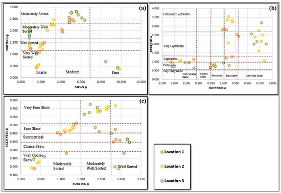
Figure 7.
Bivariate plots of Folk and Ward (1957) textural parameters for sediment samples from the Poompuhar region: (a) mean grain size vs. sorting, (b) skewness vs. kurtosis, and (c) sorting vs. skewness.
Discriminant plots further confirm fluvial dominance (Figure 8). In the mean size–sorting diagram (Figure 8a), all samples fall within the river field, which is consistent with channel-related deposition. The skewness–sorting plot (Figure 8b) similarly positions all units in the fluvial domain, excluding the beach influence. Median versus sorting (Figure 8c) places most samples in the river field, although several shift toward quiet-water zones, reflecting slackwater deposition during flood recession. The CM diagram of textural maturity (Figure 8d) shows that the sediments are poorly sorted and immature, plotting mainly within the point bar and delta-front fields, consistent with rapid aggradation during episodic floods. Overall, the bivariate and discriminant analyses document alternating high-energy and slackwater phases, which are characteristic of paleoflood deposition in the Cauvery River system.
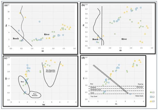
Figure 8.
Bivariate discriminant plots of sediments from Locations 1–3, indicating fluvial deposition with slackwater signals reflecting flood recession phases preserved in the stratigraphy: (a) Mz vs. SD, (b) Sk vs. SD, (c) Md vs. SD, and (d) Mz vs. SD (maturity plot).
CM Pattern
The CM diagrams (D1 vs. D50) highlight the distinct transport processes within Passega’s fields (Figure 9a). Most samples cluster in the rolling and bottom suspension and rolling domains, with a few extending into the graded suspension zone. Samples in the rolling field, defined by high D1 values (>1000 µm) and coarse medians, reflect bedload transport during peak-flood energy. In contrast, those in the bottom suspension and rolling fields show slightly lower D1 values, indicating mixed traction–suspension transport during the declining flow stages. The D50 vs. D90 relationships (Figure 9b) further emphasise fluvial dominance, as all samples plot within the river domain with D90 values consistently >1000 µm. This reflects the ability of flood flows to entrain and deposit coarse grains while simultaneously carrying finer fractions. The spread across rolling and suspension fields suggests episodic alternation between high-energy bedload transport and suspension settling during flood waning periods. Overall, the CM patterns record repeated flood activity, with high-discharge events mobilising coarse sediments, followed by quieter phases of suspension deposition. The absence of non-fluvial signatures underscores the role of episodic floods as the primary sedimentary drivers of this sequence.
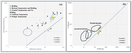
Figure 9.
CM pattern plots for sediments from Locations 1–3: (a) C (coarsest percentile) vs. M (median grain size) showing sediment transport modes—rolling, bottom suspension with rolling, graded suspension without rolling, uniform suspension, and pelagic suspension; (b) C (D90) vs. M (D50) indicating depositional environments, with samples distributed across lacustrine and fluvial domains.
4.1.6. Angularity Study
The angularity analysis across Locations 1–3 revealed a heterogeneous assemblage of sand-sized grains, reflecting variable sediment sources, transport histories, and depositional energies associated with episodic paleofloods Figure 10. At Location 1, the dominant grain types fell within the sub-angular (10.7–30.2%) and sub-rounded (8.6–25.5%) categories, indicative of moderate transport and abrasion (Figure 11). Angular grains were notably abundant in some samples, particularly Sample 2 at 600 µm (95.8%), suggesting a rapid influx of freshly eroded proximal sediments during high-energy flood pulses. Rounded and well-rounded grains, representing longer transport or reworked channel material, occurred in moderate proportions (rounded: 12.2–33.3%; well-rounded: 0.6–25.8%), particularly in Samples 6, 10, and 14, reflecting moderate-energy overbank or slackwater deposition. Very angular grains in Samples 3 and 7 further indicated episodic high-energy sediment input.
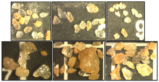
Figure 10.
Photomicrograph of sediment grains showing a high proportion of very angular to angular grains, indicating minimal transport and reworking.
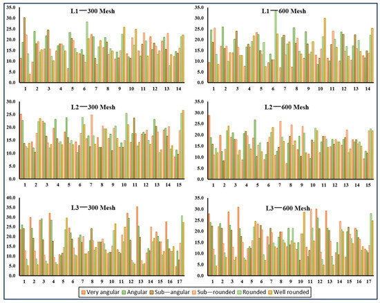
Figure 11.
Grain angularity distribution for three sediment locations at two mesh sizes (300 and 600), showing categories from very angular to well rounded. The dominance of very angular to angular grains indicates minimal transport, supporting the identification of paleoflood deposits.
4.2. Location 2
4.2.1. Lithostratigraphy
Location 2 comprised interbedded fine- and coarse-grained units, reflecting alternating energy regimes (Figure 4). Clay-rich horizons (Samples 1, 3, and 11) indicated low-energy floodplain or slackwater deposition. Poorly sorted clay–silt layers (Samples 2 and 8) represented flood pulses with limited transport capacity, whereas clay–sand beds (Samples 4, 9, and 12) marked transitional deposition during flood recession. Black clay with sand (Sample 13) suggested an organic-rich accumulation under stagnant post-flood conditions. Fine sand with clay (Samples 5 and 14) was moderately sorted and layered, recording waning flood stages. Coarse sand units (Samples 6, 10, and 15) were well sorted and thick, with sharp basal contacts (Sample 10) diagnostic of flash floods or peak discharge. Silt with sand (Sample 7) reflected moderate-energy, overbank deposition.
4.2.2. Loss on Ignition
The LOI550 values ranged from 0.7 to 4.8%, with the highest value in Sample 1 (clay), followed by Samples 4, 13, and 14, all clay-rich or organic-bearing layers (≥4.5%), indicating low-energy floodplain or slackwater deposition. The coarse sand units (Samples 6, 10, and 15) showed the lowest values (0.7–0.9%), consistent with high-energy floods. Intermediate values in transitional units (fine sand with clay and silt with sand) reflected moderate depositional energy. The CaCO3 content varied from 2.0 to 15.1%, with maximum concentrations in Samples 1, 4, 13, and 14 and the lowest values in coarse sand layers (2.0–2.5%). LOI950 values, up to 1.8, paralleled the CaCO3 distribution, confirming enhanced carbonate preservation in organic-rich clays and reduced concentrations in high-energy sands.
4.2.3. Magnetic Susceptibility
Magnetic susceptibility (MS) at Location 2 exhibited LF values from 3.07 to 5.93 × 10⁻⁸ m3/kg, reflecting variability in magnetic mineral concentration during flood and inter-flood periods. The frequency-dependent susceptibility (χfd%) ranged from 1.34 to 43.28%, peaking in Sample 11, indicating strong pedogenic enrichment of ultrafine superparamagnetic grains. The high χfd% values in Samples 3 (33.33%), 5 (24.65%), 9 (26.40%), 11 (43.28%), and 14 (39.02%) reflected soil formation under low-energy, stable conditions following flood events. The low χfd% (<2%) in Samples 2, 6, 10, and 15 corresponded to rapid sedimentation with minimal pedogenesis, which is typical of high-energy flood deposits. Sample 9, with the highest LF (5.93 × 10⁻⁸ m3/kg) and χfd% (26.40%), likely represented a well-developed paleosol or a surface with prolonged exposure. Overall, the MS patterns capture alternating high-energy deposition and post-flood soil formation, confirming their reliability as proxies for reconstructing paleoflood dynamics and sedimentation history in alluvial environments.
4.2.4. Sand–Silt–Clay
Sediments at Location 2 exhibited marked textural variability, with sand, silt, and clay contents ranging from 5.2 to 96.4%, 2.2–22.8%, and 1.1–91.7 %”. Two horizons (Samples 1 and 14) were overwhelmingly clay-dominated (88.1 and 91.7%, respectively), reflecting slackwater or floodplain deposition under low-energy, stagnant flood conditions. In contrast, most other layers (Samples 2–13 and 15) were sand-dominated (73.9–96.4%), signifying high-energy fluvial processes. Among these, Samples 6 (81.3 sand, 15.5% silt), 10 (88.4% sand), and 15 (89.1% sand) stood out as products of major flood pulses, deposited during peak discharge events with rapid sediment delivery. The alternation between fine-grained, clay-rich horizons and sand-rich units records episodic floods of varying magnitudes, with finer deposits reflecting waning stages or overbank inundation and coarser units corresponding to channel migration or sediment-laden surges. This rhythmic stratigraphy offers robust evidence of flood recurrence and intensity in the Cauvery River floodplain. The ternary diagram (Figure 5) reinforces these patterns: clay horizons plot near the clay apex, indicating slackwater sedimentation, whereas the majority of samples cluster in the sand field, consistent with channel-proximal or high-energy depositional environments. This bimodal distribution highlights alternating hydrodynamic regimes, capturing the dynamic interplay between peak floods and their waning phases.
4.2.5. Granulometric Analyses
The grain size profiles at Location 2 exhibited pronounced alternations between fine- and coarse-grained layers, reflecting fluctuating depositional energy (Figure 6; Table 2). The basal unit (Sample 1) consisted of well-sorted, fine-skewed clay with a mesokurtic distribution, indicative of low-energy slackwater or overbank deposition. Overlying very fine sand layers (Samples 2–4), poorly sorted and fine-skewed, recorded rapid deposition during moderate-energy flood pulses with substantial suspended loads. Sample 5, a poorly sorted fine sand, indicated slightly higher flow energy, likely associated with waning flood stages. High-energy deposition was evident in Sample 6, a coarse sand layer with very poor sorting, fine skewness, and a very leptokurtic character, representing a major flood capable of transporting both bedload and suspended material. This was followed by lower-energy fine layers (Sample 7) and a moderately well-sorted, symmetrical medium sand (Sample 8), indicative of uniform flow or channel reworking. Sample 9 (fine sand, poorly sorted, fine-skewed, leptokurtic) reflected overbank deposition, preceding another high-energy flood deposit in Sample 10, a coarse sand unit which was extremely leptokurtic. Medium sand layers (Samples 11–12) recorded moderately high-energy floods with slightly lower competence, whereas Sample 13 (medium sand, moderately sorted, symmetrical) reflected stable reworking under consistent flow. Sample 14, a well-sorted clay unit, denoted a calm-water phase, and the uppermost Sample 15, a coarse, poorly sorted, very fine-skewed, and extremely leptokurtic sand, signified a strong paleoflood depositing both coarse and fine fractions rapidly. The repeated alternation between fine-grained slackwater units and thick coarse sand beds highlights episodic paleofloods of different magnitudes. Samples 6, 10, and 15 were robust markers of high-energy flood events, capturing both peak discharge and suspended load dynamics. This stratigraphic and granulometric variability provides a detailed record of flood recurrence and depositional processes in the Cauvery River floodplain, offering critical insights into paleoflood frequency and magnitude.

Table 2.
Textural parameters of Location 2 sediments.
Bivariate Grain Size
Bivariate grain size analysis at Location 2 revealed significant variations in sediment texture and depositional energy (Figure 7). The mean grain size (ϕ) ranged from medium to very fine sand, with several samples exceeding 10 ϕ, reflecting the deposition of extremely fine fractions under low-energy slackwater conditions. Sorting spanned 0.4–2.5 ϕ, from very well to moderately sorted, with most samples well sorted, indicative of relatively stable depositional settings. Skewness predominantly showed a fine to very fine skew (−0.05 to 0.75), reflecting finer-tail dominance from gradual settling, while occasional coarse or symmetrical skew suggested variable sediment sources or brief high-energy pulses. Kurtosis varied from platykurtic to extremely leptokurtic, with high-kurtosis layers signifying selective sorting and minimal grain-size mixing, which is typical of flood-derived deposits. Discriminant plots further confirm fluvial deposition (Figure 8). The mean size versus standard deviation plot situates most samples within the river domain, with minor proximity to the beach field, suggesting limited reworking. Skewness versus SD and median versus SD diagrams reinforce riverine transport punctuated by moderate-to-high-energy floods, with minor slackwater influence. The maturity diagram shows poorly to moderately sorted sediments largely within point bar and delta-front fields, although localised reworking places one sample near the mature beach domain. Collectively, these analyses capture episodic high-energy paleoflood pulses interspersed with low-energy slackwater deposition, highlighting the dynamic energy fluctuations of the Cauvery River floodplain and providing robust insights into flood magnitude, frequency, and sediment transport processes.
CM Pattern
Location 2 shows a shift, with most samples positioned in the “bottom suspension and rolling” and “graded suspension” fields (Figure 9a). The D1 values range from approximately 400–1200 µm, and the median sizes are finer than those at Location 1, indicating a larger proportion of samples associated with suspension-dominated transport modes (Figure 8a). Location 2 samples plot close to the fluvial–lacustrine boundary, showing a wider range of D90 values between 500 and 1500 µm (Figure 9b).
4.2.6. Angularity Study
Location 2 showed a greater prevalence of rounded and well-rounded grains, particularly in Samples 2, 6, 9, 10, and 15, where the combined fractions exceeded 45%. For instance, Sample 15 exhibited the highest textural maturity (rounded: 25.5–22.7%; well-rounded: 26.6–21.8%), reflecting extensive reworking or deposition under low-energy channel-lag conditions (Figure 10). Angular and sub-angular grains (25–40%) indicated intermittent input from primary or short-transport sources during flood surges. Sub-rounded grains in Samples 7, 8, and 13 indicated moderate abrasion during transport. Comparable distributions across the 300 and 600 µm fractions suggested consistent textural maturity, irrespective of grain size.
4.3. Location 3
4.3.1. Lithostratigraphy
Location 3 exhibited a thick, heterogeneous stratigraphy with alternating low- and high-energy deposits (Figure 4). Clay-rich layers (Samples 1 and 3) reflected low-energy floodplain or slackwater deposition, whereas clay–silt beds (Samples 4, 9, and 13) indicated transitional flow conditions. Clay–sand units (Samples 2, 8, and 11), including laminated Sample 11, recorded waning-stage deposition and short-term energy fluctuations. Black clay with sand (Sample 12) indicated post-flood organic accumulation under stagnant conditions. Transitional silt–sand and fine sand–silt/clay beds (Samples 6, 7, 15, and 16) suggested a gradual energy decline. Thick, well-sorted coarse sand layers (Samples 5, 10, 14, and 17), particularly Samples 10 and 17 with sharp basal contacts, denoted high-energy flood pulses, with Sample 17 (56 cm) representing a major paleoflood. The overall sequence captures repeated episodes, spanning low-energy overbank settling to abrupt and high-energy sediment influx.
4.3.2. Loss on Ignition
LOI550 values ranged from 0.5 to 5.1%, peaking in Sample 12 (black clay with sand) and being high in clay-rich layers (Samples 1, 3, and 4; ≥4.0%), reflecting low-energy floodplain or slackwater deposition. Coarse sand beds (Samples 5, 10, 14, and 17) exhibited minimal LOI550 (0.5–0.9%), consistent with high-energy flood deposition. Transitional units—clay–sand, silt–sand, and fine sand–clay layers—showed intermediate LOI550, indicating moderate energy conditions. CaCO3 concentrations varied from 0.05 to 0.45%, with maxima in organic-rich clay (Sample 12) and minima in coarse sands. The LOI950 values (up to 0.45%) mirrored this pattern, highlighting enhanced carbonate preservation in low-energy, organic-rich clays and depletion in high-energy sandy layers.
4.3.3. Magnetic Susceptibility
The MS low-frequency magnetic susceptibility (LF) ranged from 4.47 to 10.57 × 10⁻⁸ m3/kg, with frequency-dependent susceptibility (χfd%) between 1.32% and 31.25%, reflecting variable sediment sources and depositional processes driven by paleofloods. Elevated χfd% in Samples 11 (31.25%), 12 (20.15%), 13 (30.67%), and 15 (29.41%) indicated pedogenic enrichment of ultrafine superparamagnetic grains under low-energy, stable conditions or deposition of suspended flood sediments. Coarse sand layers (Samples 5, 10, 14, and 17) exhibited minimal χfd% (1.32–1.62%), consistent with high-energy, detrital-dominated flood deposits. Intermediate χfd% in the fine sand–clay and silt–sand layers (Samples 6, 7, 9, and 16) reflected moderate-energy episodic deposition. Alternating high and low susceptibility highlights the episodic nature of flooding, confirming magnetic susceptibility as a reliable proxy for reconstructing paleoflood frequency, magnitude, and sediment dynamics in the floodplain.
4.3.4. Sand–Silt–Clay
The core sediments at Location 3 displayed pronounced textural heterogeneity, reflecting alternating high- and low-energy depositional phases. Sand-rich layers (Samples 5, 10, 14, and 17; 80–88.5% sand) corresponded to high-energy fluvial conditions, recording rapid deposition during major flood events. In contrast, several samples (1, 2, 3, 7, 8, 9, and 12) were enriched in silt and clay, indicative of low-energy environments associated with waning floods or slackwater settling. Notably, Sample 8 (12.3% sand, 67.6% silt, and 20.1% clay) represented very-low-energy deposition, likely reflecting floodplain sedimentation following peak flood surges. The systematic alternation of coarse and fine units across the profile captures multiple paleoflood episodes of varying magnitudes, providing critical evidence for reconstructing flood dynamics in the Cauvery River Basin.
The ternary plot highlights the broadest compositional scatter among the three locations, with sand-rich layers plotting near the sand apex, reflecting the effective transport of coarse fractions during extreme flood pulses, whereas fine-grained samples occupy the silty–clay domain, consistent with slackwater deposition. This textural variability underscores the dynamic hydrodynamic regime at Location 3, recording both high-magnitude flood surges and subsequent low-energy floodplain settling (Figure 5).
4.3.5. Granulometric Analyses
The 17-layer sequence at Location 3 displayed a complex alternation of fine silts, clays, and coarse sands, reflecting repeated fluctuations in depositional energy (Table 3; Figure 6). The basal units, Samples 1 and 2, consisted of medium silt that was very poorly sorted, symmetrical, and platykurtic, indicative of low-energy overbank or slackwater deposition with minimal sediment winnowing. Sample 3, a coarse silt layer, exhibited very poor sorting, fine skewness, and very platykurtic characteristics, reflecting a slightly higher transport energy capable of moving coarser fractions. Sample 4 (coarse silt) continued this trend with very fine skewness, suggesting short-lived moderate-energy pulses. A pronounced shift to high-energy conditions was recorded in Sample 5, a coarse sand layer that was poorly sorted, very fine-skewed, and very leptokurtic, representing a major flood capable of entraining and depositing both coarse and fine material. Samples 6 and 7, comprising very coarse and coarse silt, respectively, recorded waning flood energy, whereas Samples 8 (very fine silt, moderately well sorted) and 9 (well-sorted clay, symmetrical) reflected calm-water deposition under negligible current influence. High-energy pulses recurred in Sample 10, a coarse sand unit exhibiting extreme leptokurtosis, followed by Samples 11–13 (coarse to very coarse silt) deposited from suspension during a moderate flow. Sample 14, another coarse sand bed, indicated a subsequent high-energy flood event, whereas Samples 15 and 16 (coarse silt) reflected waning stage sedimentation. The sequence culminated with Sample 17, a thick (56 cm) coarse sand layer, poorly sorted and very fine-skewed, representing the largest flood event in the profile. Overall, the Location 3 stratigraphy documents episodic flood dynamics, with low-energy slackwater silts and clays interspersed with abrupt, coarse sand flood deposits. The thick coarse sand beds in Samples 5, 10, 14, and 17 serve as key markers of significant paleoflood episodes, capturing the dynamic energy fluctuations of the Cauvery River floodplain and providing robust evidence for reconstructing the magnitude and frequency of past extreme flood events.

Table 3.
Textural parameters of the Location 3 sediments.
Bivariate Grain Size
Bivariate grain size analysis at Location 3 revealed moderate variations in sediment characteristics, reflecting transitional depositional energy regimes (Figure 7). The mean versus sorting plot shows that most samples fell within the medium to fine sand range, with sorting values ranging from ~1.5 to 2.7 ϕ, classifying sediments as moderately well sorted to moderately sorted and indicative of fluctuating moderate-energy deposition. One sample displayed a very fine grain size with improved sorting, consistent with a localised low-energy stable setting. Skewness versus kurtosis data further indicated symmetrical to very fine-skewed distributions (0.05–0.75 ϕ), with higher skewness values denoting fine-tail dominance, which is typical of slackwater deposition. Kurtosis was platykurtic to extremely leptokurtic, highlighting variability in sediment sorting and sharpness, suggesting alternating flow regimes and episodic sediment supply. Sorting versus skewness plots corroborate these observations, confirming the prevalence of fine- to very fine-skewed, moderately sorted sediments. Discriminant analyses (Figure 8) reinforce the fluvial dominance. In the mean size versus standard deviation plot, most samples cluster within the river field, with minor proximity to the beach boundary, reflecting a limited coastal influence. The skewness versus SD and median versus SD diagrams show that most sediments are within the riverine domains, with some extending into the quiet-water field, indicating slackwater deposition during flood waning. The maturity diagram classifies sediments as poorly sorted and immature, primarily plotting in the point bar and delta-front fields, although slackwater facies are also evident. Collectively, these bivariate and discriminant analyses indicate that Location 3 preserves both high-energy flood deposits and low-energy slackwater sediments, providing critical evidence for reconstructing paleoflood events and the associated fluvial dynamics.
CM Pattern
Location 3 is characterised by a concentration of points in the “graded suspension” and “uniform suspension” fields, with D1 values generally <600 µm and finer median sizes, showing a dominance of suspension-settled sediments (Figure 9a). Location 3 samples occur near or within the lacustrine domain, with D90 values mostly below 800 µm (Figure 9b).
4.3.6. Angularity Study
Location 3 exhibited the broadest angularity spectrum, reflecting the most complex flood dynamics. Very angular and angular grains dominated Samples 1, 3, 4, and 12 (>55–60%), indicative of proximal, high-energy flood deposition with minimal abrasion (Figure 10). In contrast, Samples 9, 10, 15, and 17 were dominated by rounded and well-rounded grains (rounded: 23–30%; well-rounded: 24–27%), documenting long-distance reworking during moderate- to low-energy flood stages. Intermediate assemblages in Samples 6, 7, and 13 (sub-angular/sub-rounded 15–23%) suggested moderate transport and abrasion. No systematic angularity differences were observed between the 300 and 600 µm fractions, although minor local variations reflected hydraulic sorting.
4.4. Multi-Proxy Consistency: Quantifying Event-Bed Identification
To ensure rigorous and reproducible event-bed identification—as requested by the reviewer—a comparative analysis was performed across all three core locations, quantifying the consistency of the three primary diagnostic proxies against the 10 identified high-energy layers. The criteria were defined by strict thresholds: (1) low LOI (<3.5), (2) low frequency-dependent magnetic susceptibility (<2%), (3) a sand% above 80%, and (4) coarse mean grain size. The results of this quantification are presented in Table 4.

Table 4.
Layers Most Suitable for Paleoflood Studies Based on LOI, MS, Sand%, and Presence of Coarser Grains.
5. Discussion
5.1. Fidelity of the Paleoflood Archive: Multi-Proxy Validation
A multiproxy sedimentological investigation successfully established a high-resolution Late Holocene paleoflood stratigraphy for the lower Cauvery River near Poompuhar [35]. The fidelity of the ten identified high-energy event beds was ensured by a suite of concordant characteristics, moving beyond simple lithostratigraphy to include hydrodynamic and geochemical validation. Textural analysis indicates that the flood units are predominantly sand-dominated (>80% sand fraction), poorly sorted (>1.6Φ), and leptokurtic, reflecting chaotic, high-velocity transport conditions capable of moving and depositing large sediment loads without time for hydraulic sorting [36]. This hydrodynamic interpretation is further supported by the Passega CM diagram (Passega, 1957), which shows flood deposit clustering in the rolling and bottom-suspension fields, indicative of transport dominated by traction near the channel bed [11,12]. Geochemically, the flood horizons exhibit extremely low loss on ignition (LOI) (generally < 3.5%) [37] and consistently low frequency-dependent magnetic susceptibility (χ fd% < 2%) [38,39,40]. These proxies are critical, signifying rapid mineral deposition and quick burial, and form a methodology central to reliable paleoflood stratigraphy [32,40,41]. The concordance across these independent proxies suggests that the identified layers are consistent with high-magnitude paleoflood events in the past.
5.2. Late Holocene Chronology and Regional Climate Synchronisation
The multi-trench synchronisation of the S. No. 10 flood layer suggests that these events were likely basin-wide catastrophic extremes. Using an extrapolated long-term aggradation rate of ∼0.97 mm/year, we project a provisional chronology: the maximum-magnitude event (L3-17) is estimated to be ∼3.2 ka, while the synchronous S. No. 10 cluster aligns with OSL-dated events in the upstream Kaveri record, placing it at ∼1.6−1.8 ka [9,42]. This timeline indicates potential regional synchronisation of fluvial instability across southern peninsular India. Our ∼3.2 ka event appears to coincide with the Palar River’s first major avulsion phase (3.59−3.26 ka), which was attributed to the combined forcing of an intensified NE monsoon and neotectonic activity [16,39,43]. The subsequent Palar avulsion (2.42–1.88 ka) further brackets our ∼1.6–1.8 ka cluster. This strong chronological overlap suggests that the severe flooding recorded near Poompuhar was a local expression of a synchronised Late Holocene climato-tectonic regime that periodically exceeded the fluvial stability thresholds across coastal Tamil Nadu.
5.3. Geomorphic Thresholds and the Fluvial Abandonment of Poompuhar
Framing the flood record within its geomorphic context is key to understanding the decline of Poompuhar. As established by Mohapatra et al. (2021) [18], the delta is a relatively young post-LGM Holocene infill body, making the urbanised floodplain inherently susceptible to rapid aggradation and to channel instability. The repetitive deposition of thick sand layers (evidenced by all 10 identified deposits) (Table 5) would have caused significant channel superelevation near the coast. This process, coupled with documented regional neotectonic activity, would have created ideal conditions for the main distributary to exceed its lateral stability threshold. We propose that recurrent high-magnitude flooding, particularly the clusters around ∼3.2 ka and ∼1.6−1.8 ka, may have provided the hydraulic energy necessary to trigger catastrophic channel avulsions. This event diverted the main flow away from the city, rapidly silting the abandoned harbour channel and severing Poompuhar’s critical maritime link. This mechanism of fluvial abandonment is increasingly recognised as a major driver of the decline of ancient coastal settlements [44].

Table 5.
Flood depths were identified from three locations.
Although the sedimentary and textural evidence presented here is consistent with a fluvial flooding origin, alternative geomorphic and coastal processes could have contributed to the observed stratigraphic patterns. Local channel migration and avulsion can produce thick sand bodies and abrupt changes in channel geometry that mimic flood-event beds in terminal settings [45,46]. Relative sea-level change and delta response to the balance of river, wave, and tidal fluxes can alter sediment delivery and preservation potential along the coast [47,48]. Likewise, tidal coupling and estuarine dynamics can redistribute river-borne sediments across distributary networks, affecting where and how event beds are preserved [49]. Episodes of storm surges or coastal reworking are also capable of producing high-energy sand layers, although storm-surge deposits often carry distinctive marine proxies and geochemical signatures, for example, microfossils and Ca/Sr ratios, which can be used to discriminate them from fluvial deposits [49,50]. For these reasons, we treat our multi-proxy results as consistent with a fluvial paleoflood interpretation rather than as incontrovertible proof of causality; resolving causation decisively will require targeted geochronology and additional proxies that distinguish marine from fluvial sources (e.g., marine microfossils, elemental tracers) and assessments of channel-planform history. This balanced framing acknowledges the likely interplay of fluvial and coastal forcing in governing Late Holocene deposition across the lower Cauvery floodplain [51,52].
5.4. Geochronological Outlook: Addressing Methodological Limitations
Although the provisional chronology and regional correlations are compelling, securing a definitive, high-impact chronology requires absolute dating of event beds. Crucially, previous work on Cauvery Delta sediments [17,53] documents pervasive methodological hurdles, as the ubiquitous quartz OSL signal is often saturated and poorly bleached. Therefore, the next critical step is to apply an advanced technique successfully employed in this region: elevated-temperature post-IR IRSL dating of K-feldspar, interpreted using a Minimum Age Model (MAM) [54]. This will allow for the robust quantification of the recurrence intervals of the 10 paleofloods and establish a definitive link between Late Holocene hydrological extremes and the terminal decline of this historically significant port city.
6. Conclusions
This study presents the first robust, multi-proxy validated paleoflood stratigraphy for the lower Cauvery River, unequivocally identifying 10 Late Holocene high-energy event beds. The concordance among physical, magnetic, and hydrodynamic proxies confirms that these deposits are true archives of basin-wide catastrophic flooding, not local channel variability. Each flood bed is characterised by an average thickness of 8–15 cm, mean grain size ranging from 120 to 240 µm, and magnetic susceptibility values of 35–65 × 10−8 m3/kg, reflecting distinct, high-energy depositional episodes. The estimated flood magnitudes suggest paleo-discharge peaks of approximately 6000 ± 500 m3/s, consistent with the regional high-magnitude events recorded in peninsular river systems. The derived tentative chronology reveals a critical synchronisation with regional geomorphology: the estimated ∼3.2 ka and ∼1.6–1.8 ka flood clusters align directly with documented phases of channel avulsion in the Palar River, underscoring that fluvial instability was driven by a regional climato-tectonic threshold rather than localised processes. This hydrological evidence provides strong support for the central hypothesis that repeated high-magnitude floods caused channel superelevation and the ultimate avulsion of the Cauvery distributary. This process would have cut off the vital maritime link, leading directly to the fluvial abandonment and decline of Poompuhar.
Although this study provides robust insights into paleoflood dynamics, several limitations remain. The chronology is currently tentative, owing to reliance on proxy-based age extrapolation, and sediment reworking or lateral variability may affect the representativeness of the sampled cores. Future work will focus on K-feldspar post-IR IRSL dating to obtain absolute ages, the collection of additional sedimentary profiles across the floodplain to improve lateral coverage, numerical modelling of paleoflood hydraulics, and archaeological correlation to better constrain the timing and impact of floods on Poompuhar. Addressing these limitations will enhance our understanding of the Late Holocene flood regimes and their societal implications in coastal Tamil Nadu.
Author Contributions
Conceptualization, S.M.; methodology, S.M. and S.R.; software, S.M.; validation, S.M.; formal analysis, S.M.; investigation, S.M. and S.R.; resources, S.M.; data curation, S.M.; writing—original draft preparation, S.M.; writing—review and editing, S.M. and S.R.; visualization, S.M.; supervision, S.R.; project administration, S.M. and S.R.; funding acquisition, S.R. All authors have read and agreed to the published version of the manuscript.
Funding
This research received no external funding.
Data Availability Statement
The original contributions presented in this study are included in the article. Further inquiries can be directed to the corresponding author.
Acknowledgments
The authors would like to thank the reviewers from MDPI-GeoHazards The authors wish to formally acknowledge the Department of Science & Technology (DST)—Science and Heritage Research Initiative (SHIR), Government of India, for their generous financial support towards the project ‘Digital Poompuhar’, which enabled this study to be conducted to understand the location of paleoflood sediment deposition.
Conflicts of Interest
The authors declare no conflict of interest.
References
- Wilhelm, B.; Amann, B.; Corella, J.P.; Rapuc, W.; Giguet-Covex, C.; Merz, B.; Støren, E. Reconstructing Paleoflood Occurrence and Magnitude from Lake Sediments. Quaternary 2022, 5, 9. [Google Scholar] [CrossRef]
- Benito, G.; Greenbaum, N.; Medialdea, A.; Calle, M.; Sanchez-Moya, Y.; Machado, M.; Ballesteros-Cánovas, J.A.; Corella, J.P. Late Pleistocene—Holocene multi-decadal patterns of extreme floods in NW Iberia: The Duero River palaeoflood record. Quat. Sci. Rev. 2023, 321, 108356. [Google Scholar] [CrossRef]
- Hardeng, J.; Bakke, J.; Cederstrøm, J.M.; Forsmo, J.; Haugen, T.A.; Sabatier, P.; Nagel Støren, E.W.; van der Bilt, W.G.M. A 7000-year record of extreme flood events reconstructed from a threshold lake in southern Norway. Quat. Sci. Rev. 2024, 331, 108659. [Google Scholar] [CrossRef]
- Srisunthon, P.; Berger, A.; Fuelling, A.; Abdulkarim, M.; Ertlen, D. Reconstructing the Flood History of Nan Ancient City: Insights from Sedimentary Analysis. In EGU General Assembly Conference Abstracts; EGU: Munich, Germany, 2024; p. 8164. [Google Scholar]
- Wei, Q.; Qi, H.; Luo, W.; Tseng, D.; Ki, S.J.; Wan, Z.; Göröcs, Z.; Bentolila, L.A.; Wu, T.; Sun, R.; et al. Fluorescent Imaging of Single Nanoparticles and Viruses on a Smart Phone. ACS Nano 2013, 7, 7472. [Google Scholar] [CrossRef]
- Toonen, W.H.J.; Munoz, S.E.; Cohen, K.M.; Macklin, M.G. High-Resolution Sedimentary Paleoflood Records in Alluvial River Environments: A Review of Recent Methodological Advances and Application to Flood Hazard Assessment; Springer International Publishing: Berlin/Heidelberg, Germany, 2020; ISBN 9783030233150. [Google Scholar]
- Baker, V.R. Paleoflood hydrology: Origin, progress, prospects. Geomorphology 2008, 101, 1–13. [Google Scholar] [CrossRef]
- Holden, J. Surface water hydrology. Water Resour. An Integr. Approach 2019, 25, 61–97. [Google Scholar] [CrossRef]
- Behera, D.; Kumar, P.; Kumar, M. A Terrestrial record of ~3000 years of extreme floods from the Kaveri and adjacent river basins, Tamil Nadu, India. Quat. Int. 2025, 738, 109856. [Google Scholar] [CrossRef]
- Goswami, K.; Rawat, M.; Jaiswal, M.K.; Kale, V.S. Luminescence chronology of late-Holocene palaeofloods in the upper Kaveri basin, India: An insight into the climate-flood relationship. Holocene 2019, 29, 1094–1104. [Google Scholar] [CrossRef]
- Ramkumar, M.; Balasubramani, K.; Kumaraswamy, K.; Santosh, M.; Roy, P.D.; Manobalaji, A.; Juni, K.J.; Nagarajan, R.; Sharma, R.; Kumar, P.; et al. Geosystems and Geoenvironment Episodic habitation and abandonment of Neolithic civilization sites in the Vaigai River Basin, Southern India. Geosystems Geoenvironment 2022, 1, 100007. [Google Scholar] [CrossRef]
- Mu, R.; Kumaraswamy, K.; Balasubramani, K.; Nagarajan, R.; Santosh, M. Archimer Neolithic cultural sites and extreme climate related channel avulsion: Evidence from the Vaigai River Basin, southern India. J. Archaeol. Sci. Rep. 2021, 40, 103204. [Google Scholar]
- Ramkumar, M.; Kumaraswamy, K.; Balasubramani, K.; Abdul Rahaman, S.; Jegankumar, R.; Kumara Ganesh, U.; Manikandan, E.; Balasundareshwaran, A.; Prithiviraj, G.; Ayyanthurai, R.; et al. Discovery of buried historical structures in the Kaveri–Kollidam interfluve, southern India. Archaeol. Prospect. 2019, 26, 73–88. [Google Scholar] [CrossRef]
- Palani, B.; Vasudevan, S.; Ramkumar, T.; Rajendiran, S.; Gunasekaran, S. Determination of sedimentation rates and life of Kodaikanal Lake, South India, using radiometric dating (210Pb and 137Cs) techniques. Environ. Earth Sci. 2023, 82, 228. [Google Scholar] [CrossRef]
- Resmi, M.R.; Achyuthan, H.; Babeesh, C. Holocene evolution of the Palar river, Southern India: Tracking history of migration, provenance, weathering and tectonics. Quat. Int. 2020, 575–576, 358–374. [Google Scholar] [CrossRef]
- Resmi, M.R.; Achyuthan, H.; Kumar, M. Middle to late Holocene paleochannels and migration of the Palar River, Tamil Nadu: Implications of neotectonic activity Middle to late Holocene paleochannels and migration of the Palar River, Tamil Nadu: Implications of neotectonic activity. Quat. Int. 2016, 443, 211–222. [Google Scholar] [CrossRef]
- Alappat, L.; Tsukamoto, S.; Singh, P.; Srikanth, D.; Ramesh, R.; Frechen, M. Chronology of cauvery delta sediments from shallow subsurface cores using elevated-temperature post-IR IRSL dating of feldspar. Geochronometria 2010, 37, 37–47. [Google Scholar] [CrossRef]
- Mohapatra, P.P.; Stephen, A.; Singh, P.; Prasad, S.; Anupama, K. Catena Pollen based inference of Holocene sea level changes, depositional environment and climatic history of Cauvery delta, Southern India. Catena 2021, 199, 105029. [Google Scholar] [CrossRef]
- Baker, V.R. Paleoflood hydrology and extraordinary flood events. J. Hydrol. 1987, 96, 79–99. [Google Scholar] [CrossRef]
- Magalingam, S.; Radhakrishnan, S.; Karuppannan, S.; Alam, E.; Islam, M.K. Demarcating paleoflood repositories using documentary evidence and flood geomorphic landforms. Quat. Sci. Adv. 2025, 18, 100281. [Google Scholar] [CrossRef]
- Ramasamy, S.M.; Saravanavel, J.; Palanivel, K.; Kumanan, C.J.; Rajasekhar, D. Detection of submerged harbour using GEBCO and MBES data, in the offshore region of ancient port city Poompuhar, South India. Curr. Sci. 2020, 119, 526–534. [Google Scholar] [CrossRef]
- Sasilatha, T.; Mohendran, G.; Kumar, M.A. Interpreting the Underwater Data and Revealing the Historic Submerged Port—Poompuhar. Earth Sci. Hum. Constr. 2023, 3, 119–124. [Google Scholar] [CrossRef]
- Lissa, M.; Bhuvaneswari, V.; Devi, T.; Kumar, J.S.; Rajeswari, R. Semantic data model for knowledge representation and dissemination of cultural heritage site, Poompuhar. Curr. Sci. 2022, 123, 1237–1245. [Google Scholar] [CrossRef]
- Sridhar, A.; Thakur, B.; Basavaiah, N.; Seth, P.; Tiwari, P.; Chamyal, L.S. Lacustrine record of high magnitude flood events and climate variability during mid to late Holocene in the semiarid alluvial plains, western India. Palaeogeogr. Palaeoclimatol. Palaeoecol. 2020, 542, 109581. [Google Scholar] [CrossRef]
- Ramasamy, S.; Saravanavel, J.; Yadava, M.G.; Ramesh, R. Radiocarbon dating of some palaeochannels in Tamil Nadu and their significance. Curr. Sci. 2006, 91, 1609–1613. [Google Scholar]
- Dabrio, C.J.; Santisteban, J.I.; Mediavilla, R.; Lo, E.; Castan, S.; Zapata, M.B.R.; Jose, M. Loss on ignition: A qualitative or quantitative method for organic matter and carbonate mineral content in sediments? J. Paleolimnol. 2004, 32, 287–299. [Google Scholar] [CrossRef]
- Heiri, O.; Lotter, A.F.; Lemcke, G. Loss on ignition as a method for estimating organic and carbonate content in sediments: Reproducibility and comparability of results. J. Paleolimnol. 2001, 25, 101–110. [Google Scholar] [CrossRef]
- Anchuela, P.; Casas-sainz, A.M.; Pueyo, E.L. Analysis of the ferromagnetic contribution to the susceptibility by low field and high field methods in sedimentary rocks of the Southern Pyrenees and Northern Ebro foreland basin (Spain) es Pocov. Terra Nova 2013, 25, 307–314. [Google Scholar] [CrossRef]
- Hrouda, F.; Pokorný, J.; Ježek, J.; Chadima, M. Out-of-phase magnetic susceptibility of rocks and soils: A rapid tool for magnetic granulometry. Geophys. J. Int. 2013, 194, 170–181. [Google Scholar] [CrossRef]
- Sivanandam, Y.; Saranaathan, S.E. Characterisation of Pre and Post-Tsunami Sediments by Grain Size Analysis Using G2Sd Package in R Programming from Nagoor to Poompuhar, Tamil Nadu, India. J. Geol. Soc. India 2023, 99, 1379–1386. [Google Scholar] [CrossRef]
- Sivanandam, Y.; Saranaathan, S.E.; Loveson, V.J. Comparative study of granulometric and granule trend of pre- and post-tsunami sediments with recent beach sediments from Nagoor to Poompuhar, Tamil Nadu. J. Earth Syst. Sci. 2024, 133, 146. [Google Scholar] [CrossRef]
- Folk, R.L.; Ward, W.C. Brazos River Bar: A Study in the Significance of Grain Size Parameters. J. Sediment. Petrol. 1957, 27, 3–26. [Google Scholar] [CrossRef]
- Raja, P.; Achyuthan, H.; Geethanjali, K.; Kumar, P.; Chopra, S. Late Pleistocene Paleoflood Deposits Identified by Grain Size Signatures, Parsons Valley Lake, Nilgiris, Tamil Nadu. J. Geol. Soc. India 2018, 91, 547–553. [Google Scholar] [CrossRef]
- Benito, G.; Thorndycraft, V.R.; Rico, M.; Sánchez-Moya, Y.; Sopeña, A. Palaeoflood and floodplain records from Spain: Evidence for long-term climate variability and environmental changes. Geomorphology 2008, 101, 68–77. [Google Scholar] [CrossRef]
- Wang, S.; Wang, N.; Zhang, Y.; Huang, C.; Zhu, Y.; Xiao, Q.; Chen, D.; Wang, H.; Ming, Y.; Huang, X.; et al. Geochemistry of a paleo-oxbow lake sediments and its implications for the late Holocene extreme overbank fl ooding history of the Yellow River within the Zoige Basin, NE Tibetan Plateau. Front. Earth Sci. 2023, 11, 1144283. [Google Scholar] [CrossRef]
- Sandoval-rincón, K.P.; Garrote-revilla, J.; Vázquez-tarrío, D.; Cervel, S.; López-vinielles, J.; Mateos, R.M.; Ballesteros-cánovas, J.A.; Benito, G.; Díez-herrero, A. PaleoRiada: A new integrated spatial database of palaeofloods in Spain. Earth Syst. Sci. Data Discuss. 2025, 2025, 1–25. [Google Scholar]
- Kale, V.S.; Achyuthan, H.; Jaiswal, M.K.; Sengupta, S. Palaeoflood records from upper kaveri river, Southern India: Evidence for discrete floods during holocene. Geochronometria 2010, 37, 49–55. [Google Scholar] [CrossRef]
- Pang, H.; Jia, Y.; Li, F.; Qin, L.; Chen, L. An improved method for paleoflood reconstruction from core sediments in the upper Yellow River. Front. Earth Sci. 2023, 11, 1149502. [Google Scholar] [CrossRef]
- Wilhelm, B.; Ballesteros Canovas, J.A.; Corella Aznar, J.P.; Kämpf, L.; Swierczynski, T.; Stoffel, M.; Støren, E.; Toonen, W. Recent advances in paleoflood hydrology: From new archives to data compilation and analysis. Water Secur. 2018, 3, 1–8. [Google Scholar] [CrossRef]
- Petter, L.; Stevens, T.; Almqvist, B.; Snowball, I.; Wiers, S.; Költringer, C.; Lu, H.; Zhang, H.; Lin, Z. Magnetic susceptibility parameters as proxies for desert sediment provenance. Aeolian Res. 2020, 46, 100615. [Google Scholar] [CrossRef]
- Pang, H.; Jia, Y. Sedimentary Records of Paleoflood Events in the Desert Section of the Upper Yellow River Since the Late Quaternary. Atmosphere 2025, 16, 1019. [Google Scholar] [CrossRef]
- Mahadev; Singh, A.K.; Jaiswal, M.K. Application of luminescence age models to heterogeneously bleached quartz grains from flood deposits in Tamilnadu, southern India: Reconstruction of past flooding. Quat. Int. 2019, 513, 95–106. [Google Scholar] [CrossRef]
- Resmi, M.R.; Achyuthan, H.; Jaiswal, M.K. Holocene tectonic uplift using geomorphometric parameters, GIS and OSL dating: Palar River basin, southern peninsular India. Z. Fur Geomorphol. 2017, 61, 243–265. [Google Scholar] [CrossRef]
- Fryirs, K.A.; Brierley, G.J. Geomorphic Analysis of River Systems: An Approach to Reading the Landscape; John Wiley & Sons: Chichester, UK; Hoboken, NJ, USA, 2012; ISBN 9781405192750. [Google Scholar]
- Hwang, T.; Roy, S. Downstream changes in river avulsion style are related to channel morphology. Nat. Commun. 2020, 11, 2116. [Google Scholar] [CrossRef]
- Ganti, V.; Chadwick, A.J.; Hassenruck-gudipati, H.J.; Lamb, M.P. Avulsion cycles and their stratigraphic signature on an experimental backwater-controlled delta. J. Geophys. Res. Earth Surf. 2016, 121, 1651–1675. [Google Scholar] [CrossRef]
- Nienhuis, J.H.; Kim, W.; Milne, G.A.; Quock, M.; Slangen, A.B.A.; Törnqvist, T.E. River Deltas and Sea-Level Rise. Annu. Rev. Earth Planet. Sci. 2023, 51, 79–104. [Google Scholar] [CrossRef]
- Water Resources Research-2025-Bacopoulos-Rate of Sea-Level Rise and Sediment Characteristics Modulate Deltaic.pdf. Available online: https://agupubs.onlinelibrary.wiley.com/doi/pdf/10.1029/2024WR039056 (accessed on 1 October 2025).
- Rivers, T. Chapter 6 The classification problem; Addison-Wesley Professional: Hoboken, NJ, USA, 1995. [Google Scholar]
- Yao, Q.; Liu, K.; Zhang, Z.; Rodrigues, E.; Cohen, M.; Maiti, K.; Yang, Y. What Are the Most Effective Proxies in Identifying Storm-Surge Deposits in Paleotempestology? A Quantitative Evaluation From the Sand-Limited, Peat-Dominated Environment of the Florida Coastal Everglades. Geochem. Geophys. Geosystems 2023, 24, e2022GC010708. [Google Scholar] [CrossRef]
- Kongsen, S.; Phantuwongraj, S.; Choowong, M. Distinguishing Late Holocene Storm Deposit from Shore-normal Beach Sediments from the Gulf of Thailand. Front. Earth Sci. 2021, 9, 625926. [Google Scholar] [CrossRef]
- Peng, F.; Prins, M.A.; Kasse, C.; Cohen, K.M.; van der Putten, N.; van der Lubbe, J.; Toonen, W.H.J.; Van Balen, R.T. An improved method for paleoflood reconstruction and flooding phase identification, applied to the Meuse River in the Netherlands. Glob. Planet. Change 2019, 177, 213–224. [Google Scholar] [CrossRef]
- Alappat, L.; Vink, A.; Tsukamoto, S.; Frechen, M. Establishing the Late Pleistocene-Holocene sedimentation boundary in the southern North Sea using OSL dating of shallow continental shelf sediments. Proc. Geol. Assoc. 2010, 121, 43–54. [Google Scholar] [CrossRef]
- Alappat, L.; Frechen, M.; Ramesh, R.; Tsukamoto, S.; Srinivasalu, S. Journal of Asian Earth Sciences Evolution of late Holocene coastal dunes in the Cauvery delta region of Tamil Nadu, India. J. Asian Earth Sci. 2011, 42, 381–397. [Google Scholar] [CrossRef]
Disclaimer/Publisher’s Note: The statements, opinions and data contained in all publications are solely those of the individual author(s) and contributor(s) and not of MDPI and/or the editor(s). MDPI and/or the editor(s) disclaim responsibility for any injury to people or property resulting from any ideas, methods, instructions or products referred to in the content. |
© 2025 by the authors. Licensee MDPI, Basel, Switzerland. This article is an open access article distributed under the terms and conditions of the Creative Commons Attribution (CC BY) license (https://creativecommons.org/licenses/by/4.0/).