Next Issue
Volume 9, May
Previous Issue
Volume 9, March


Hydrology, Volume 9, Issue 4 (April 2022) – 14 articles

Cover Story (view full-size image): 
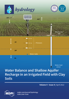
Quantifying soil water budget components and characterizing groundwater recharge from irrigation seepage are important for effective water resources management. This research conducted in a pod sprinkler-irrigated field with clay soils showed irrigation water moved relatively rapidly through the soil profile into the groundwater. A soil water balance approach was used to estimate deep percolation based on field measurements of irrigation, soil moisture, and weather variables. Groundwater level data were used to estimate aquifer recharge. Study results provided critical information to better understand the mechanisms of water transport through the vadose zone and into shallow aquifers in agricultural fields with fine-textured soils in the Pacific Northwest region in the USA. View this paper
  • Issues are regarded as officially published after their release is announced to the table of contents alert mailing list.
  • You may sign up for e-mail alerts to receive table of contents of newly released issues.
  • PDF is the official format for papers published in both, html and pdf forms. To view the papers in pdf format, click on the "PDF Full-text" link, and use the free Adobe Reader to open them.
Order results
Result details
Section
Select all
Export citation of selected articles as:
19 pages, 6881 KiB  
Article
Using a Bed Sill as a Countermeasure for Clear-Water Scour at a Complex Pier with Inclined Columns Footed on Capped Piles
by Mahdi Esmaeili Varaki, Negar Tavazo and Alessio Radice
Hydrology 2022, 9(4), 65; https://doi.org/10.3390/hydrology9040065 - 16 Apr 2022
Cited by 1 | Viewed by 1918
Abstract
River bridge piers may collapse due to the local scour around their foundations. It is known that local scour is an effect of the three-dimensional flow field that develops near the pier and that the geometric complexity of a non-cylindrical pier may, correspondingly, [...] Read more.
River bridge piers may collapse due to the local scour around their foundations. It is known that local scour is an effect of the three-dimensional flow field that develops near the pier and that the geometric complexity of a non-cylindrical pier may, correspondingly, increase the complexity of the process. It is also known that various devices may be used as scour countermeasures. This manuscript explores the use of a bed sill as a countermeasure for local scour at a complex bridge pier compound of an array of piles, a pile cap, and two inclined columns with the rectangular sections above the cap. This pier geometry, never studied before in combination with a scour countermeasure, was stimulated by an existing bridge. Different sill placements were tested (at the upstream or downstream edges of the pier, or in an intermediate position) for various values of the pile diameter and number, cap thickness and cap elevation. The results of a wide experimental campaign consistently showed that the most effective placement of the transverse sill was at the upstream edge of the pier, for which scour reductions of up to 30–40% could be obtained for the long-term scour depth. The countermeasure performance decreased to about 10% when the sill was placed at the downstream edge of the pier. Furthermore, the installation of a transverse sill upstream of the pier also changed the shape of the scour hole because the pier was then located in an area prone to sill scour; however, for the present experiments, the combination of the effects was beneficial in terms of the resulting scour depth. Although the investigation of a single hydro-dynamic condition prevents the experimental findings from being generalized, the promising results stimulate further consideration of a transverse sill as a countermeasure for local scour at a complex pier. Full article
(This article belongs to the Section Hydrological and Hydrodynamic Processes and Modelling)
Show Figures

Figure 1

21 pages, 2104 KiB  
Article
A Water Balancing Act: Water Balances Highlight the Benefits of Community-Based Adaptive Management in Northern New Mexico, USA
by Lily M. Conrad, Alexander G. Fernald, Steven J. Guldan and Carlos G. Ochoa
Hydrology 2022, 9(4), 64; https://doi.org/10.3390/hydrology9040064 - 14 Apr 2022
Cited by 1 | Viewed by 2675
Abstract
Quantifying groundwater recharge from irrigation in water-scarce regions is critical for sustainable water management in an era of decreasing surface water deliveries and increasing reliance on groundwater pumping. Through a water balance approach, our study estimated deep percolation (DP) and characterized [...] Read more.
Quantifying groundwater recharge from irrigation in water-scarce regions is critical for sustainable water management in an era of decreasing surface water deliveries and increasing reliance on groundwater pumping. Through a water balance approach, our study estimated deep percolation (DP) and characterized surface water and groundwater interactions of two flood-irrigated fields in northern New Mexico to evaluate the regional importance of irrigation-related recharge in the context of climate change. DP was estimated for each irrigation event from precipitation, irrigation input, runoff, change in soil water storage, and evapotranspiration data for both fields. Both fields exhibited positive, statistically significant relationships between DP and total water applied (TWA), where one field exhibited positive, statistically significant relationships between DP and groundwater level fluctuation (GWLF) and between GWLF and total water applied. In 2021, total DP on Field 1 was 739 mm, where 68% of irrigation water applied contributed to DP. Field 2′s total DP was 1249 mm, where 81% of irrigation water applied contributed to DP. Results from this study combined with long-term research indicate that the groundwater recharge and flexible management associated with traditional, community-based irrigation systems are the exact benefits needed for appropriate climate change adaptation. Full article
(This article belongs to the Special Issue Integrated Surface Water and Groundwater Analysis)
Show Figures

Figure 1

22 pages, 3914 KiB  
Review
First Flush Stormwater Runoff in Urban Catchments: A Bibliometric and Comprehensive Review
by Marla Maniquiz-Redillas, Miguel Enrico Robles, Gil Cruz, Nash Jett Reyes and Lee-Hyung Kim
Hydrology 2022, 9(4), 63; https://doi.org/10.3390/hydrology9040063 - 09 Apr 2022
Cited by 18 | Viewed by 4552
Abstract
First flush is a phenomenon in stormwater runoff that has been considered a topic of great interest in the field of nonpoint source pollution. Despite several attempts to define the first flush quantitively, the specified characteristics of the phenomenon vary among sources. To [...] Read more.
First flush is a phenomenon in stormwater runoff that has been considered a topic of great interest in the field of nonpoint source pollution. Despite several attempts to define the first flush quantitively, the specified characteristics of the phenomenon vary among sources. To address these uncertainties, a bibliometric and comprehensive review on published articles related to first flush was conducted. A corpus of 403 research articles was obtained from the Scopus database, which was then parsed using the CorText Manager for the bibliometric analysis. The study examined quantitative definitions of first flush from various sources; climate and topographic characteristics of monitoring and experimental sites where the studies on first flush were performed; the sample collection methods applied; the first flush values obtained on the studies and how it influenced the nonpoint source pollution in urban watersheds. A network map, two contingency matrices, and a Sankey diagram were created to visualize the relationship of significant keywords related to first flush, as well as their co-occurrences with journals, countries, and years. It was found that the strength of the first flush effect could vary depending on the geographical location of the site, climatic conditions, and the pollutants being analyzed. Therefore, initial rainfall monitoring, runoff sampling, and water quality testing were seen as critical steps in characterizing the first flush in urban catchments. Furthermore, the characterization of first flush was found to be significant to the selection of best management practices and design of low-impact development (LID) technologies for stormwater runoff management and nonpoint source pollution control. Full article
(This article belongs to the Special Issue Stormwater/Drainage Systems and Wastewater Management)
Show Figures

Figure 1

19 pages, 7493 KiB  
Article
Modeling the Hydrologic Performance and Cost-Effectiveness of LID in a Residential Park Area Using a Decentralized Design Approach
by Sergi Garbanzos and Marla Maniquiz-Redillas
Hydrology 2022, 9(4), 62; https://doi.org/10.3390/hydrology9040062 - 08 Apr 2022
Cited by 6 | Viewed by 2865
Abstract
Low Impact Development (LID) is one of the current research interests toward green infrastructures and urban flood control that have the capability to return developed watersheds to pre-development hydrological conditions, bringing numerous water quantity and quality benefits, while being cheaper than their traditional [...] Read more.
Low Impact Development (LID) is one of the current research interests toward green infrastructures and urban flood control that have the capability to return developed watersheds to pre-development hydrological conditions, bringing numerous water quantity and quality benefits, while being cheaper than their traditional counterparts. However, there is a current research gap about LIDs within tropical regions. This study aims to evaluate the cost efficiency of LID scenarios in varying surface areas through a cost-effectiveness (C/E) analysis and to assess flow reduction and infiltration improvement of the cost-effective LID scenarios using US EPA Stormwater Management Model (SWMM) in a tropical residential catchment receiving an annual rainfall of 1780.5 mm (70.1″), under a Type 1 Philippine Climate. Results have shown that the Weibull plotting position generated the largest rainfall amounts. A total of 2112 manually simulated LID scenarios were modeled to obtain the cost-effective or optimal LID scenarios, where they can generate a maximum of 38.67% flow reduction and 29.73% peak flow reduction, all observed in the multiple LID scenarios. At high rainfall amounts, the multiple LID scenarios can also peak at a 1113% increase in total infiltration in the given sub-catchments. Determining the target capture goal, applicable LID types, and cost estimations from a pilot project are vital components in the future application of LIDs in these regions. Full article
(This article belongs to the Special Issue Stormwater/Drainage Systems and Wastewater Management)
Show Figures

Graphical abstract

20 pages, 5746 KiB  
Article
An Improved Groundwater Model Framework for Aquifer Structures of the Quaternary-Formed Sediment Body in the Southernmost Parts of the Mekong Delta, Vietnam
by Tran Viet Hoan, Karl-Gerd Richter, Nicolas Börsig, Jonas Bauer, Nguyen Thi Ha and Stefan Norra
Hydrology 2022, 9(4), 61; https://doi.org/10.3390/hydrology9040061 - 06 Apr 2022
Cited by 7 | Viewed by 3028
Abstract
The Ca Mau peninsula (CMP) is a key economic region in southern Vietnam. In recent decades, the high demand for water has increased the exploitation of groundwater, thus lowering the groundwater level and leading to risks of degradation, depletion, and land subsidence, as [...] Read more.
The Ca Mau peninsula (CMP) is a key economic region in southern Vietnam. In recent decades, the high demand for water has increased the exploitation of groundwater, thus lowering the groundwater level and leading to risks of degradation, depletion, and land subsidence, as well as salinity intrusion in the groundwater of the whole Mekong Delta region. By using a finite element groundwater model with boundary expansion to the sea, we updated the latest data on hydrogeological profiles, groundwater levels, and exploitation. The basic model setup covers seven aquifers and seven aquitards. It is determined that the inflow along the coastline to the mainland is 39% of the total inflow. The exploitation of the study area in 2019 was 567,364 m3/day. The most exploited aquifers are the upper-middle Pleistocene (qp2–3) and the middle Pliocene (n22), accounting for 63.7% and 24.6%, respectively; the least exploited aquifers are the upper Pleistocene and the upper Miocene, accounting for 0.35% and 0.02%, respectively. In the deeper aquifers, qp2–3 and n22, the change in storage is negative due to the high exploitation rate, leading to a decline in the reserves of these aquifers. These groundwater model results are the calculations of groundwater reserves from the coast to the mainland in the entire system of aquifers in the CMP. This makes groundwater decision managers, stakeholders, and others more efficient in sustainable water resources planning in the CMP and Mekong Delta (MKD). Full article
Show Figures

Figure 1

12 pages, 21748 KiB  
Article
Soil Water Balance and Shallow Aquifer Recharge in an Irrigated Pasture Field with Clay Soils in the Willamette Valley, Oregon, USA
by Daniel G. Gómez, Carlos G. Ochoa, Derek Godwin, Abigail A. Tomasek and María I. Zamora Re
Hydrology 2022, 9(4), 60; https://doi.org/10.3390/hydrology9040060 - 04 Apr 2022
Cited by 6 | Viewed by 2580
Abstract
Quantifying soil water budget components, and characterizing groundwater recharge from irrigation seepage, is important for effective water resources management. This is particularly true in agricultural fields overlying shallow aquifers, like those found in the Willamette Valley in western Oregon, USA. The objectives of [...] Read more.
Quantifying soil water budget components, and characterizing groundwater recharge from irrigation seepage, is important for effective water resources management. This is particularly true in agricultural fields overlying shallow aquifers, like those found in the Willamette Valley in western Oregon, USA. The objectives of this two-year study were to (1) determine deep percolation in an irrigated pasture field with clay soils, and (2) assess shallow aquifer recharge during the irrigation season. Soil water and groundwater levels were measured at four monitoring stations distributed across the experimental field. A water balance approach was used to quantify the portioning of different water budget components, including deep percolation. On average for the four monitoring stations, total irrigation applied was 249 mm in 2020 and 381 mm in 2021. Mean crop-evapotranspiration accounted for 18% of the total irrigation applied in 2020, and 26% in 2021. The fraction of deep percolation to irrigation was 28% in 2020 and 29% in 2021. The Water Table Fluctuation Method (WTFM) was used to calculate shallow aquifer recharge in response to deep percolation inputs. Mean aquifer recharge was 132 mm in 2020 and 290 mm in 2021. Antecedent soil water content was an important factor influencing deep percolation. Study results provided essential information to better understand the mechanisms of water transport through the vadose zone and into shallow aquifers in agricultural fields with fine-textured soils in the Pacific Northwest region in the USA. Full article
(This article belongs to the Special Issue Integrated Surface Water and Groundwater Analysis)
Show Figures

Figure 1

16 pages, 51869 KiB  
Article
Synoptic Time Scale Variability in Precipitation and Streamflows for River Basins over Northern South America
by Hernán D. Salas, Juliana Valencia, Alejandro Builes-Jaramillo and Alejandro Jaramillo
Hydrology 2022, 9(4), 59; https://doi.org/10.3390/hydrology9040059 - 31 Mar 2022
Cited by 2 | Viewed by 2893
Abstract
The synoptic mode of variability (SMV) refers to changes in atmospheric conditions over periods ranging from 2 to 10 days. In tropical regions, this variability is driven by tropical waves that have a clear signal on the wavenumber–frequency power spectra of precipitation. This [...] Read more.
The synoptic mode of variability (SMV) refers to changes in atmospheric conditions over periods ranging from 2 to 10 days. In tropical regions, this variability is driven by tropical waves that have a clear signal on the wavenumber–frequency power spectra of precipitation. This study uses the ensemble empirical mode decomposition (EEMD) method to identify the SMV in daily precipitation and streamflows in 47 river basins over northern South America. We found the presence of the frequency bands with periods of 3–12 days and 6–18 days, which agrees with the SMV associated with tropical waves that modulate precipitation over the region. Furthermore, our results reveal that variance explained by the SMV in rainfall over each catchment is greater than the variance explained by those SMV in streamflows, which suggests that catchments efficiently filter out this variability. We found that SMV explains from 5% to 20% of streamflow variability for catchments ranging from 1000 km2 to 5000 km2. Additionally, the variance explained by SMV decreases as a power fit with the catchment area. Thus, this study characterizes the SMV for potential applications on regional hydrology, diagnosis, modeling, short-time forecasting, prediction, and management of water resources. Full article
(This article belongs to the Section Hydrology–Climate Interactions)
Show Figures

Figure 1

16 pages, 4374 KiB  
Article
Determination of Skin Friction Factor in Gravel Bed Rivers: Considering the Effect of Large-Scale Topographic Forms in Non-Uniform Flows
by Masoud Kazem, Hossein Afzalimehr, Mohammad Nazari-Sharabian and Moses Karakouzian
Hydrology 2022, 9(4), 58; https://doi.org/10.3390/hydrology9040058 - 31 Mar 2022
Cited by 1 | Viewed by 2170
Abstract
Determination of skin friction factor has been a controversial topic, particularly in gravel-bed rivers where total flow resistance is influenced by the existence of small-scale skin roughness and large-scale topographic forms. The accuracy of existing models predicting skin friction factors in conditions where [...] Read more.
Determination of skin friction factor has been a controversial topic, particularly in gravel-bed rivers where total flow resistance is influenced by the existence of small-scale skin roughness and large-scale topographic forms. The accuracy of existing models predicting skin friction factors in conditions where small-scale skin roughness and large-scale topographic forms exist is very low. The objective of this study is to develop a modified model that improves the accuracy of the determination of skin friction factors in gravel-bed rivers. To this end, 100 velocity profile data obtained from eight gravel-bed rivers were utilized to develop an analytical method that considers the momentum thickness of the boundary layer and its deviation in large-scale topographic bedforms in a 1D force-balance model. The results show that the accuracy of the skin friction factors is enhanced when (1) the model is in the form of an exponential function of energy slope, and (2) the deviation of momentum thickness is considered in the model. The proposed model results in high accuracy of the predicted skin friction factors for energy slopes between 0.001 and 0.1, which exist in most gravel-bed rivers with different morphologies. Additionally, this study model was used to modify the classic Einstein–Strickler equation. The modified equation resulted in improved accuracy of the predicted skin friction factors in non-uniform flow conditions even when velocity profiles and energy slope were not available. Full article
Show Figures

Figure 1

5 pages, 200 KiB  
Editorial
Flood Early Warning and Risk Modelling
by Marina Iosub and Andrei Enea
Hydrology 2022, 9(4), 57; https://doi.org/10.3390/hydrology9040057 - 31 Mar 2022
Viewed by 1852
Abstract
The evolution of mankind during the last 2 centuries has generated an ever growing thrive for increased production, for the need to create novel means to generate energy and for society to change into a more consumerism-oriented version [...] Full article
(This article belongs to the Special Issue Flood Early Warning and Risk Modelling)
20 pages, 2686 KiB  
Article
AquaCrop Simulation of Winter Wheat under Different N Management Practices
by Nicholas Dercas, Nicolas R. Dalezios, Stamatis Stamatiadis, Eleftherios Evangelou, Antonios Glampedakis, Georgios Mantonanakis and Nicholaos Tserlikakis
Hydrology 2022, 9(4), 56; https://doi.org/10.3390/hydrology9040056 - 29 Mar 2022
Cited by 1 | Viewed by 2743
Abstract
AquaCrop is a well-known water-oriented crop model. The model has been often used to simulate various crops and the water balance in the field under different irrigation treatments, but studies that relate AquaCrop to fertilization are rare. In this study, the ability of [...] Read more.
AquaCrop is a well-known water-oriented crop model. The model has been often used to simulate various crops and the water balance in the field under different irrigation treatments, but studies that relate AquaCrop to fertilization are rare. In this study, the ability of this model to simulate yield and the water balance parameters was investigated in a wheat field under different nitrogen management practices. During the 2015–2016 and 2016–2017 growing seasons, meteorological data were provided from a nearby meteorological station, and the evolution of soil water content and final yields were recorded. The model showed a very good performance at simulating the soil water content evolution in the root zone. Notwithstanding its simplicity, AquaCrop based on a semi-quantitative approach for fertility performed well at the field level for the final yield estimation under different nitrogen treatments and field topography variation. Although the correlation coefficient between simulated and measured final yields was high, increased values of variations were observed in the various zones of this experimental field (−50% to +140%). The model appears to be an efficient tool for evaluating and improving the management practices at the field level. The experiments were conducted in Thessaly, which is the largest plain and the main agricultural area of Greece. Thessaly, however, has a strong negative water balance, which has led to a strong decrease in the level of the aquifer and, at the same time, to sea intrusion. There is also a significant risk of contamination of the groundwater aquifer due to increased use of agrochemicals. This analysis is particularly important for Thessaly due to the need for improvement of agricultural practices in this area, to decrease the pressure of agricultural activities on natural resources (soil, water) and reverse the consequences of current management. Full article
(This article belongs to the Special Issue Drought and Water Scarcity: Monitoring, Modelling and Mitigation)
Show Figures

Figure 1

9 pages, 1448 KiB  
Opinion
Effective Transfer of Science to Operations in Hydrometeorology Considering Uncertainty
by Konstantine P. Georgakakos
Hydrology 2022, 9(4), 55; https://doi.org/10.3390/hydrology9040055 - 27 Mar 2022
Viewed by 1856
Abstract
The ability to effectively transfer results of research in hydrometeorology to operational field applications is met with several challenges. This article exemplifies cooperative implementation that explicitly considers the flow of uncertainty from data and models to products and predictions as a means to [...] Read more.
The ability to effectively transfer results of research in hydrometeorology to operational field applications is met with several challenges. This article exemplifies cooperative implementation that explicitly considers the flow of uncertainty from data and models to products and predictions as a means to successfully meet these challenges. Full article
(This article belongs to the Collection Feature Papers of Hydrology)
Show Figures

Figure 1

18 pages, 2671 KiB  
Article
Importance of Fog and Cloud Water Contributions to Soil Moisture in the Andean Páramo
by Gina Berrones, Patricio Crespo, Ana Ochoa-Sánchez, Bradford P. Wilcox and Rolando Célleri
Hydrology 2022, 9(4), 54; https://doi.org/10.3390/hydrology9040054 - 26 Mar 2022
Cited by 8 | Viewed by 3352
Abstract
Páramos are particular ecosystems of the Tropical Andes, where fog and low-intensity rainfall such as drizzle are commonly frequent—but the contribution of these water sources to soil water replenishment and discharge is not yet clear, mainly because the development of techniques for separating [...] Read more.
Páramos are particular ecosystems of the Tropical Andes, where fog and low-intensity rainfall such as drizzle are commonly frequent—but the contribution of these water sources to soil water replenishment and discharge is not yet clear, mainly because the development of techniques for separating fog from drizzle and wind-driven rainfall has been challenging. Fog was measured with a cylindrical Juvik gauge and types of precipitation other than fog with a high-resolution disdrometer. Soil moisture was measured at 100 mm depth by means of Water Content Reflectometers, then Effective precipitation (EP) was calculated. We categorized events as two types: fog only (FO) and cloud water (CW). We found that in the case of FO events, only small amounts reached the soil (EP ranged between 0.1 and 0.2 mm); in contrast, greater amounts of EP originated from CW events (maximum value of 4.3 mm). Although we found that FO events are negligible for stream water contribution; they are ecologically important for maintaining high relative humidity, low net radiation, and consequently low evapotranspiration rates. Our research provides new insights into the hydrological role of fog, enabling us to better understand to what extent its input influences the water resources of the Andean páramo. Full article
(This article belongs to the Section Ecohydrology)
Show Figures

Figure 1

27 pages, 5765 KiB  
Article
Flood-Pulse Variability and Climate Change Effects Increase Uncertainty in Fish Yields: Revisiting Narratives of Declining Fish Catches in India’s Ganga River
by Nachiket Kelkar, Rohan Arthur, Subhasis Dey and Jagdish Krishnaswamy
Hydrology 2022, 9(4), 53; https://doi.org/10.3390/hydrology9040053 - 25 Mar 2022
Cited by 2 | Viewed by 4131
Abstract
River-floodplains support a significant number of small-scale capture fisheries despite having undergone degradation due to human modification of river flows by dams, pollution, and climate change. River fish production is underpinned by the annual flood-pulse and associated environmental changes that act as cues [...] Read more.
River-floodplains support a significant number of small-scale capture fisheries despite having undergone degradation due to human modification of river flows by dams, pollution, and climate change. River fish production is underpinned by the annual flood-pulse and associated environmental changes that act as cues for spawning and dispersal for most species. However, studies on fish stock declines have focused more on overfishing than on hydroclimatic variability. Therefore, understanding how changes in flood-pulse variability influence fishing effort and yields is critical to inform adaptive fisheries’ management. We investigated hydroclimatic factors driving flood-pulse variability and fish catch–effort dynamics in India’s Ganga River over two decades (2000–2020). We compiled fishers’ narratives of changing fish catches through semi-structured interviews to compare them with our observed trends. Flood amplitude showed increasing variability, longer duration, and earlier rise timings, linked to La Niña and El Niño phases. Catches per unit effort were correlated with total yield and effort but did not decline as fishers thought, despite overall declines in yield over time. Hydroclimatic variability was a more significant driver of changing yields than local fishing pressure. Rising uncertainty in fisheries’ production, in response to increasing flood-pulse variability and altered flows in the Gangetic Plains, may be affecting fishing behaviour and underlying resource conflicts. Full article
(This article belongs to the Special Issue Aquatic Ecosystems and Water Resources)
Show Figures

Figure 1

11 pages, 2430 KiB  
Article
Inflow Quantification in Urban Sewer Networks
by Isabel Bentes, Danilo Silva, Carlos Vieira and Cristina Matos
Hydrology 2022, 9(4), 52; https://doi.org/10.3390/hydrology9040052 - 24 Mar 2022
Cited by 5 | Viewed by 2308
Abstract
The improper waterflow to wastewater treatment plants (WWTP) due to rainwater inflow, and infiltration is a growing concern due to the many problems it brings to the sector, ranging from infrastructure deterioration to environmental problems caused by untreated wastewater and to the eventual [...] Read more.
The improper waterflow to wastewater treatment plants (WWTP) due to rainwater inflow, and infiltration is a growing concern due to the many problems it brings to the sector, ranging from infrastructure deterioration to environmental problems caused by untreated wastewater and to the eventual financial costs that these issues cause. The study was carried out at the Folhadela WWTP, Vila Real, Portugal, between May 2014 and May 2015, with the total effluent flows recorded every 2 min at the entrance of the WWTP. Rainfall data from the Vila Real Meteorological Station, corresponding to the same period, were used. The study allowed us to conclude that from the wastewater that flowed to the Folhadela WWTP, in the months of study, only 15% is domestic wastewater, and the remaining 85% were undesirable volumes. Of these, 47% were infiltration flows, and 38% were rainwater flows that are not taken into account when dimensioning networks and WWTPs. These flows also have the particularity of representing very high volumes in short periods of time, coinciding with heavy rains, representing a very high risk for drainage and treatment infrastructures. Regarding the infiltration flow rates, as a general rule, they are taken into account when dimensioning the networks as being a percentage of the total flow. However, it is necessary to take into account the magnitude and the evolution of these values according to the network age and state of conservation, as well as have straight regulations about the undue connections into the network. Full article
(This article belongs to the Special Issue Stormwater/Drainage Systems and Wastewater Management)
Show Figures

Figure 1

Previous Issue
Next Issue
Back to TopTop