You are currently viewing a new version of our website. To view the old version click .

ISPRS International Journal of Geo-Information, Volume 11, Issue 4

April 2022 - 58 articles

Cover Story: 
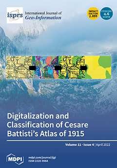
The paper presents an automated methodology for the digital acquisition of thematic information from historical maps. A customized procedure of object-based image analysis (OBIA) and filtering was applied to digitize and georeference a map of the forest density of Trentino, which is part of the atlas “Il Trentino. Economic Statistical Illustration” by Cesare Battisti (1915). The vector map obtained was used for a qualitative and quantitative diachronic analysis of the dynamics of the wooded areas of this Alpine region. Forest coverage in this region has been documented using maps for more than two centuries. This map represents a data point in a time series that is currently studied to identify changes in forest density and pattern. This will allow the creation of scenarios for future forest evolution, supporting the preservation of ecological features and biodiversity. View this paper
  • Issues are regarded as officially published after their release is announced to the table of contents alert mailing list .
  • You may sign up for email alerts to receive table of contents of newly released issues.
  • PDF is the official format for papers published in both, html and pdf forms. To view the papers in pdf format, click on the "PDF Full-text" link, and use the free Adobe Reader to open them.

Articles (58)

  • Article
  • Open Access
3 Citations
3,123 Views
19 Pages

Quantitative relations between topological similarity degree and map scale change of multi-scale contour clusters are vital to the automation of map generalization. However, no method has been proposed to calculate the relations. This paper aims at f...

  • Article
  • Open Access
7 Citations
3,732 Views
20 Pages

Increasing Access to Cultural Heritage Objects from Multiple Museums through Semantically-Aware Maps

  • Cristina Portalés,
  • Pablo Casanova-Salas,
  • Javier Sevilla,
  • Jorge Sebastián,
  • Arabella León and
  • Jose Javier Samper

Geographical information is gaining new momentum as an analysis and visualization tool for collections of cultural objects. It provides all kinds of users with new opportunities to contextualize and understand these objects in ways that resemble our...

  • Article
  • Open Access
6 Citations
3,599 Views
16 Pages

An Information Fusion Model between GeoSOT Grid and Global Hexagonal Equal Area Grid

  • Qingmei Li,
  • Xin Chen,
  • Xiaochong Tong,
  • Xuantong Zhang and
  • Chengqi Cheng

In order to cope with the rapid growth of spatiotemporal big data, data organization models based on discrete global grid systems have developed rapidly in recent years. Due to the differences in model construction methods, grid level subdivision and...

  • Article
  • Open Access
5 Citations
3,133 Views
22 Pages

Structural Differences of PM2.5 Spatial Correlation Networks in Ten Metropolitan Areas of China

  • Shuaiqian Zhang,
  • Fei Tao,
  • Qi Wu,
  • Qile Han,
  • Yu Wang and
  • Tong Zhou

The cross-impact of environmental pollution among cities has been reported in more research works recently. To implement the coordinated control of environmental pollution, it is necessary to explore the structural characteristics and influencing fac...

  • Article
  • Open Access
11 Citations
3,456 Views
17 Pages

The magnitude of highly dynamic spatial data is expanding rapidly due to the instantaneous evolution of mobile technology, resulting in challenges for continuous queries. We propose a novel indexing approach model, namely, the Velocity SpatioTemporal...

  • Article
  • Open Access
44 Citations
5,128 Views
22 Pages

Existing optical remote sensing image change detection (CD) methods aim to learn an appropriate discriminate decision by analyzing the feature information of bitemporal images obtained at the same place. However, the complex scenes in high-resolution...

  • Article
  • Open Access
8 Citations
4,255 Views
25 Pages

Determining how to reasonably allocate shelters in the central area of the city and improve evacuation efficiency are important issues in the field of urban disaster prevention. This paper introduces the methodology and mathematical model from the fi...

  • Article
  • Open Access
12 Citations
5,544 Views
21 Pages

Spatial media bring out new forms of interaction with places, leading to the emergence of new ways of embodying the experience. The perception of place and its dynamics of change has been multiplied by the emergence of digital platforms, which create...

  • Article
  • Open Access
54 Citations
12,666 Views
18 Pages

This paper aims to explore the spatiotemporal pattern of traffic accidents using five years of data between 2015 and 2019 for the Irbid Governorate, Jordan. The spatial pattern of traffic-accident hotspots and their temporal evolution were identified...

  • Article
  • Open Access
3 Citations
3,922 Views
17 Pages

Analyzing Air Pollutant Reduction Possibilities in the City of Zagreb

  • Nikola Kranjčić,
  • Dragana Dogančić,
  • Bojan Đurin and
  • Anita Ptiček Siročić

This paper aims to present possible areas to plant different vegetation types near traffic jams to reduce air pollution in the capital of Croatia, the city of Zagreb. Based on main traffic road and random forest machine learning using WorldView-2 Eur...

of 6

Get Alerted

Add your email address to receive forthcoming issues of this journal.

XFacebookLinkedIn
ISPRS Int. J. Geo-Inf. - ISSN 2220-9964Creative Common CC BY license