Review

Bibliometric Analysis of OGC Specifications between 1994 and 2020 Based on Web of Science (WoS)

1
Key Laboratory of Digital Earth Science, Aerospace Information Research Institute, Chinese Academy of Sciences (AIRCAS), Beijing 100094, China
2
University of Chinese Academy of Sciences (UCAS), No.19 Yuquan Road, Shijingshan District, Beijing 100049, China
3
International Research Center of Big Data for Sustainable Development Goals (CBAS), Beijing 100094, China
4
Center for Spatial Information Science and Systems (CSISS), George Mason University, Fairfax, VA 22030, USA
5
Ocean College, Minjiang University, Fuzhou 350108, China
*
Author to whom correspondence should be addressed.
ISPRS Int. J. Geo-Inf. 2022, 11(4), 251; https://doi.org/10.3390/ijgi11040251
Submission received: 22 January 2022 / Revised: 30 March 2022 / Accepted: 8 April 2022 / Published: 11 April 2022

Abstract

:
The Open Geospatial Consortium (OGC) is an international non-profit standards organization. Established in 1994, OGC aims to make geospatial information and services FAIR-Findable, Accessible, Interoperable, and Reusable. OGC specifications have greatly facilitated interoperability among software, hardware, data, and users in the GIS field. This study collected publications related to OGC specifications from the Web of Science (WoS database) between 1994 to 2020 and conducted a literature analysis using Derwent Data Analyzer and VosViewer, finding that OGC specifications have been widely applied in academic fields. The most productive organizations were Wuhan University and George Mason University; the most common keywords were interoperability, data, and web service. Since 2018, the emerging keywords that have attracted much attention from researchers were 3D city models, 3D modeling, and smart cities. To make geospatial data FAIR, the OGC specifications SWE and WMS served more for “Findable”, SWE contributed more to “Accessible”, WPS and WCS served more for “Interoperable”, and WPS, XML schemas, WFS, and WMS served more for “Reusable”. The OGC specification also serves data and web services for large-scale infrastructure such as the Digital Earth Platform of the Chinese Academy of Sciences.

1. Introduction

The Open Geospatial Consortium (OGC) is a voluntary consensus standards organization dedicated to creating royalty-free, publicly available, open geospatial standards, with more than 530 organizational members from industries, governments, academia, and nonprofit. Established in 1994, OGC has made significant achievements in setting open geospatial industry standards that have been widely used for a world where everyone benefits from using geospatial information and supporting technologies [1]. The OGC standards include abstract specifications and implementation specifications. The term ‘specification’ rather than ‘standard’ is used to reflect the common usage by Geographic Information Systems (GIS) scientists.
The OGC specifications are devoted to making geospatial information and services FAIR, or Findable, Accessible, Interoperable, and Reusable. OGC specifications cover multiple fields, including environment, smart cities, the Internet of Things (IoT), sensor networks, mobile communication, 3D and architectural environments, emergency and disaster response, energy, and public utilities. If data providers produce the data and software vendors develop GIS software by following the relevant OGC specifications, users can access the data or use the software conveniently, and more importantly, the data and software can interoperate over the network without additional effort. Although data providers, software vendors, and users may be from different research fields, they can work as if they were on the same platform in the same research context.
OGC has been making geospatial data and services FAIR by developing voluntary consensus specifications. OGC develops specifications concerning location information for fields related to GIS. These specifications are considered the “products” of OGC that enable interoperability between different software components through a unified interface. In this paper, we focus on the implementation specifications.
OGC implementation specifications have six classifications according to the intent of its purposes. As shown in Figure 1, OGC specifications include six parts that have logical connections from the bottom “Sensors” to the “Data Models and Encodings”, “Containers”, “Services and APIs”, “Discovery”, and the “PubSub, Syndication, and Context” at the top. This study summarizes these six parts into four tiers based on their functions: Cyberinfrastructure Tier, Data Tier, Service Tier, and Client & Users Tier. The Cyberinfrastructure Tier in red at the bottom is for data collection. The Data Tier in blue is for data models and encodings, the Service Tier in green is for algorithm and schema repositories, and the Client & User Tier in orange at the top works with containers, discovery, PubSub, Syndication, and Context applications for clients and users.
Over the last two decades, there have been many trans-disciplines studies related to OGC specifications. The existing studies of OGC specifications focus on the Sensor Web Enablement (SWE) specification framework [2], the CityGML [3], and application examples such as public and environmental health surveillance and crisis management [4], web-based technologies for processing large and heterogeneous datasets [5], integration of key geospatial technologies for mapping within the language of OGC specifications [6], Location-based Services (LBS) [7], and geospatial data models [8]. Big data stakeholders including data producers, data collectors, administrators, and users have continuously put forth efforts to produce, exchange, use, process, and share geospatial information according to OGC specifications.
Bibliometrics is the application of mathematical and statistical methods to the quantitative analysis of publications. The field has helped multiple disciplines gain perspective and make discoveries since it was first introduced in 1969 [9]. In GIS, bibliometrics has been used to discover trends in research on soil erosion from 1932 to 2013 [10], GIS from 1961 to 2010 [11,12], and global remote sensing from 1991 to 2010 [13]. Moreover, bibliometrics has also been used to summarize the situation and trends of geo-ontology research worldwide [14], and the applications of Google Earth [15].
This study presents a quantitative literature analysis of the entire volume of information collected from the various publication outputs of the OGC specifications, and then, uses a quantitative analysis to report on the general state of the literature, research tendencies, and hotspots identified by Citation Burst and the Betweenness Centrality. The analysis and visualization tools were Excel, the Derwent Data Analyzer (DDA), Wordle, and the VOSviewer. DDA is developed by the Institute for Scientific Information (ISI) and now belongs to Clarivate Analytics. Developed specifically for the WoS database, the DDA software is convenient for users to extract information from WoS fields. Wordle produces word clouds based on the frequency of keywords. The VOSviewer is a freely accessible bibliometric and scientometric visualization analysis tool. It was developed by Nees Jan van Eck and Ludo Waltman at Leiden University’s Centre for Science and Technology Studies (https://www.vosviewer.com/download, accessed on 29 August 2021) for supporting research assessment and strategic decision making and for developing science policy. VOSviewer is widely accepted by researchers in library science. It provides the co-occurrence relationship among authors, organizations, countries, and cited papers.
This study answers whether OGC specifications are comprehensive enough and of good quality for users of the GIS community, what are the further needs for OGC specifications from these articles, and the question of how OGC specifications facilitate FAIR geospatial data, as shown in Figure 2.

2. Methodology and Data Collection

This study used a systematic review with eight stages: formulating the review question, defining inclusion and exclusion criteria, developing a search strategy, selecting studies, extracting data, assessing study quality, analyzing and interpreting results, and disseminating the findings [16]. As far as this quantitative bibliometric analysis paper is concerned, there are two commonly used approaches: the first is to sample the top in revealing the view of the OGC specifications from the macroscopic perspectives according to its wide use and the second is to look at the evolution of research hotspots evolution in different temporal and geographical contexts.

2.1. Data Collection

This study used ISI Web of Science (WoS), an authentic platform for global scientists to communicate frontier fields with peers, as the source of data for bibliometric analysis. An important and unique feature of WoS is that it includes all the cited references for every record created [17]. We chose the WoS Core Collection as our data source for this study. The WoS Core Collection holds eight databases, covering research articles published in journals and conference proceedings in both science and social science from 1900 to the present.
The search expression term was obtained by combining all different expressions of the word “OGC” and all 70 published OGC specification names by the Boolean “OR” logic. The OGC specifications are available at https://www.ogc.org/docs/is (accessed on 22 January 2021). We conducted a Topic Search by searching the combined expression term in the Title, Abstract, and the Author’s Keywords fields on the WoS Core Collection on 22 January 2021.
The search returned 963 pieces of literature written in seven languages, covering 60 countries or regions, associated with 80 WoS Categories (WC). The publications include Proceedings Paper (527), Article (422), Review (10), Data Article (3), and Editorial Material (1). Most of the publications were written in English (942) yet some others were in Spanish, Korean, Italian, French, Russian, and Slovak. Considering all the literature has an English title, abstract, and keywords, we decided to keep all the records without language discrimination. No records were found before 1994 when OGC was established. The earliest four were published in 1999.

2.2. Data Cleaning

In the data we obtained from WoS, the fields of the Authors (AU), Affiliations (AF), and Authors Keywords (AK) needed to be normalized. For example, before analysis, the keywords needed to have synonyms merged. In this study, we cleaned the data manually using DDA.
We combined 175 different name expressions out of the total 2683 AU, e.g., we combined “Baumann, P” with “Baumann, Peter” which was the standard form according to their same addresses. Furthermore, we merged 64 different units of the total 925 AF, e.g., the units of “George Mason Univ”, for example, in this study represented different expressions of “Ctr Spatial Informat Sci & Syst”, “Ctr Spatial Informat & Sci Syst CSISS”, “Ctr Intelligent Spatial Comp”, “Joint Ctr Intelligent Spatial Comp Coll Sci”, etc. from George Mason University. Moreover, we merged 872 synonyms of the total 2305 AK; for example, the expressions “open geospatial consortium” or “Open Geospatial Consortium (OGC)” were merged into the keyword “OGC”. We also mixed the different expressions of the OGC specifications names such as “WMS” which stands for “Web Map Service”, “Web Map Service (WMS)”, and “web map server”. We conducted similar keyword merges for WPS, WMS, WFS, WCS, CityGML, OWS, SWE, SOS, SDI, GML, and so on.
Data acquisition, processing, and analysis process are described and shown in Figure 3.

2.3. Bibliometric Indicators

Commonly used indicators of scientific literature in WoS include WC, Number of Publications (NP), Total Citation Times (TC), Year Published (PY), the average number of Citations Per Paper (CPP), Author Co-citation Analysis (ACA), Document Co-citation Analysis (DCA), Co-word Analysis (CA), and many other variations [18]. In this study, WC was used to illustrate the research fields covered by the whole body of publications. NP described how much global research was published associated with the OGC specifications. TC was used to determine the impact of a paper, an author, a journal, or a certain time. TC, counted year by year by WoS as the literature published, gives an index to CPP, then it consequently provides a quantitative representation of how high-impact a subject/year/journal is. CPP is calculated in many forms. For example, CPP_subject stands for a specific WC area, CPP_year is for a specific period or a certain timespan, and a CPP_journal stands for a specific journal. How CPP is calculated is shown below.
CPP subject _ year _ journal = TC subject _ year _ journal NP subject _ year _ journal

3. Quantitative Analysis and Results

3.1. Publication Outputs

We obtained a total of 963 pieces of literature on the OGC specifications from WoS. The earliest papers first appeared in 1999. The NP on the OGC specifications between 1999 and 2020 is shown in Figure 4. In the first six years (1999–2004), 24 papers were published, about 2.5% of the total, with an average of four papers/year, which is a relatively low amount when compared to 2009–2013, when 405 papers were published, 42% of the total, at an average that increased sharply to 81 papers per year.
There was a continuous increase in the NP from 2003 to 2008 and a surge from 2008 to 2009. The increase in the NP from 2003 to 2008 can be explained by developing interest in the OGC specifications. For example, some papers highlighted the interactive manner for disseminating geospatial information to the public through the Web based on OGC CORBA and Simple Features Specifications [19] and emphasized the interaction with the data provider to enable dataset discovery and metadata retrieval and sorting based on the OGC Catalog Services specification at that time [20]. In 2009, when the NP reached its peak at 97 papers per year, the main research topic was turning to specifications such as Web Processing Service (WPS), Sensor Web Enablement (SWE), and Sensor Observation Service (SOS).

3.2. Major Countries and Regions

Figure 5 shows the major countries and regions that published 10 or more papers on the OGC specification. The top five productive countries were the USA with 202 papers, China with 195, Germany with 170, Italy with 83, and Spain with 70, totaling 614 published papers, which is 63.75% of the total.
According to the OGC specification bibliometric profile, 59 main countries and regions were found in which research was conducted and applied. The OGC specifications have continuously been researched in many countries or regions, which greatly facilitates the use of interoperable technologies in data and service sharing. Some papers were collaborated on by authors from many countries. For example, one study with the authors from the United Kingdom, United States, China, Germany, Ireland, and Canada reviewed how Sensor Web, Citizen Sensing, and “human-in-the-loop sensing” enabled decision-makers to use real-time crowdsourced data in public health and emergencies in the Mobile and Social Web era through the OGC SWE and Open GeoSMS [4]. A study by the authors from China and the USA described a service-oriented multi-purpose SOS framework for creating a single method of access to the heterogeneity of sensor data through OGC CSW, Transactional Web Feature Service (WFS-T), and Transactional Web Coverage Service (WCS-T) [21].
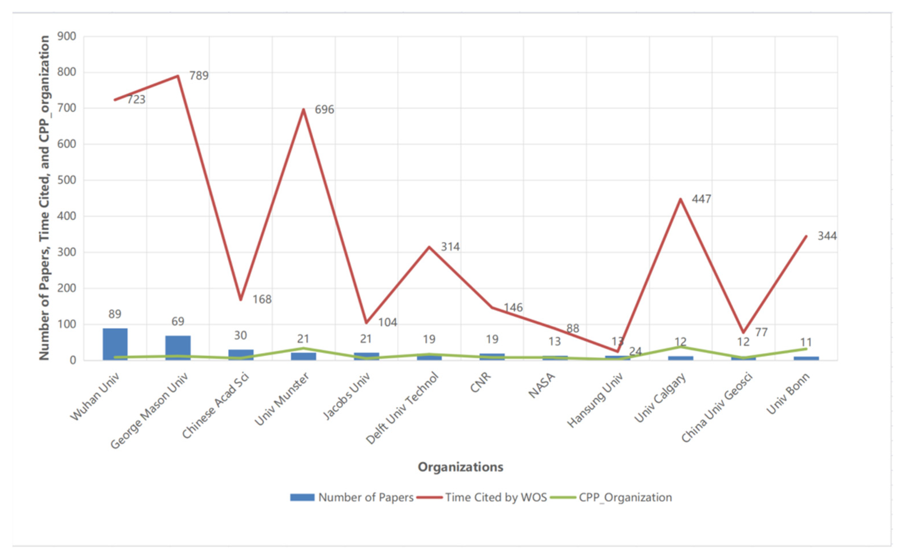
In the paper profile, about 860 organizations took part in studying the OGC specifications, among which Wuhan University published 88 papers, and George Mason University published 69. Twelve organizations were selected because they each produced more than ten papers, accounting for 34% of total papers and 23% of total citations. Figure 6 showed the NP, TC, and CPP of the organizations in the WoS, sorted by NP in reverse order.
Wuhan University and George Mason University created a semantics-enhanced geospatial catalog service for solving the inadequacy of discovering geospatial information in Cyberinfrastructure based on the OGC Registry Information Model (ebRIM) of a geospatial catalog service [22]. Beijing Transportation Information Center and the Chinese Academy of Sciences introduced a Distributed Virtual Geographic Environment (DVGE) system for an Internet-based virtual 2D and 3D environment for sharing geospatial programs, data, and software. The architecture and working mechanisms were developed based on the specifications of grid services, Open Geodata Interoperability Specifications (OpenGIS), and GML [23].
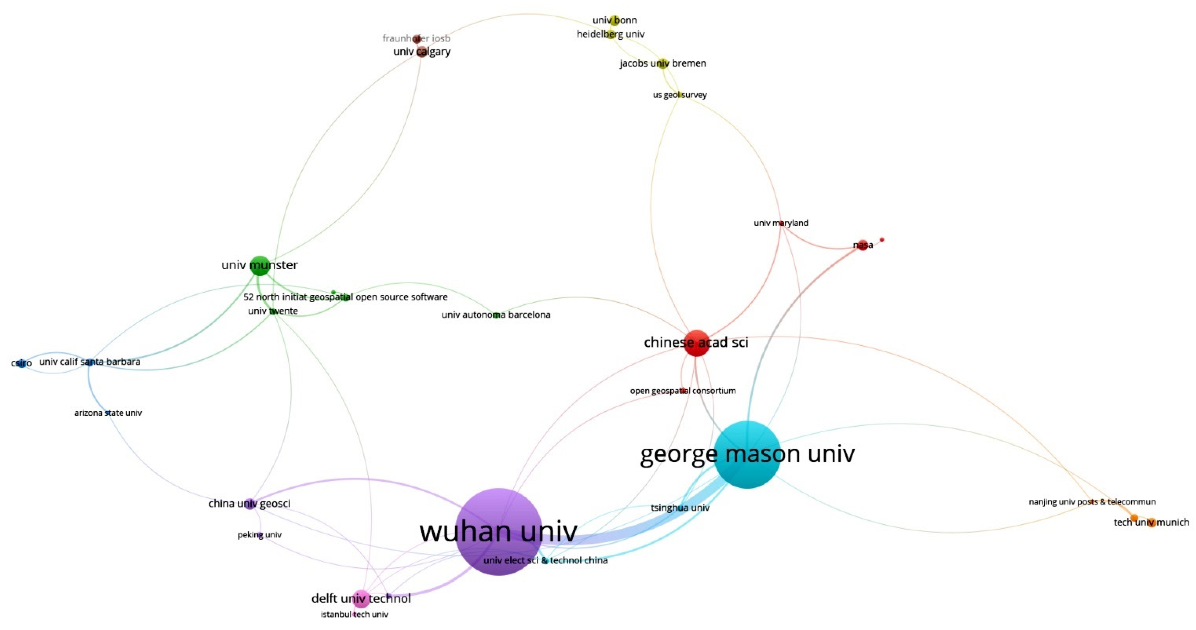
We conduct a co-authorship cluster analysis on the organizations that published five or more with VosViewer to show the collaborative relationships among the organizations. Figure 7 shows the result of the cluster analysis of co-authorship organizations, some of the 48 organizations were not connected to each other so they were not shown.

3.3. Core Journals

In the 963-publication OGC bibliometric profile, 478 publications were in Journals, Series Conferences, and Books. Based on Bradford’s law of paper scattering, a small number of “core journals” carry a large number of papers. To identify the core journals, we used Bradford’s law to do an evidence-based analysis of the publications. Developed in 1934, Bradford’s law describes that scientific publications can be arranged in order of descending productivity of papers on a given subject and divided into three zones containing the same number of papers, with a first zone of “core journals” with the least number of journals that carry the most efficient number of papers, a second zone of “relative journals” with more publications yet the same number of papers as the first zone, and a third zone of “edge journals” with the greatest number of publications. The number of publications from the three zones will follow a 1:n:n2 rule, where “n” is a multiplier [24].
We arranged the paper count of each publication by descending order as shown in column B of Table 1. Columns C, D, and E showed that the papers were divided into three zones, which contained almost the same number of papers, i.e., 312:307:344. Column F shows the count of publications in three zones, i.e., 23:111:344.
According to Bradford’s Law, the number of publications from the three zones follows the relationship 1:n:n2, then, if n = 4,
1 : n : n 2 = 23 : 92 : 368     23 : 111 : 344
The result matched Bradford’s Law. The 23 publications were the core journals of OGC specification research in WoS. The core journals we found are shown in Table 2, and each of the core journals published more than seven papers.
In Table 3, The IEEE International Geoscience And Remote Sensing Symposium (IGARSS) was the most productive source for OGC specification research, in which 51 papers were published, cited 83 times. The CPP of IGARSS was 1.63 times. IGARSS has become an important platform for OGC specification researchers. The two most cited papers were about XML and CSW in IGARSS. An open web GIS service system based on the web GIS architecture of OGC was introduced and implemented, through which interoperability, open environment, and spatial data transfer format could be provided based on XML [25]. A semantic search was enabled in Catalogue Service for the Web (CSW) by extending OGC ebRIM elements based on the semantic relationship defined in OWL/OWL-S [26]. For comprehensive access and collaborative planning or controlling the available remote sensor information in a time-critical disaster emergency, the SensorModel V1.0 prototype was designed and implemented based on the OGC SWE Initiative in 2011 [27] in IGARSS.
From the TC view, Computers & Geosciences was the most cited journal in this analysis, in which 31 papers were cited 613 times, making it the highest CPP_journal up to 19.77 times, accounting for 9% of the total of 6818 citations. The most cited paper in Computers & Geosciences was about a heavy need for common markup language for exchanging generic geoscience information in 2005 and the authors developed an approach based on the OGC Geography Markup Language (GML) to share geoscientific information of boreholes, text, and structural geology [28]. The second most cited paper was about OGC Sensor Observation Service (SOS) and Web Feature Service (WFS) in the journal. SOS and WFS were used to develop an approach for supporting flood risk management by combining information provided by Wireless Sensor Networks (WSN) and Volunteered Geographic Information (VGI), which confirmed that interoperable specifications could support the integration of heterogeneous data [29]. Table 3 shows NP, TC, and CPP_journal in reverse order. Only those publications with more than 50 TC were selected.

3.4. Research Fields

OGC specifications have been used in numerous fields and gained significant popularity in recent years. In this study, it was found that OGC specifications were referenced in 80 WoS Categories (WC). The most productive research fields were Remote Sensing, Computer Science Information Systems, and Geography Physical. Among the total literature, the eight most productive research fields covered over 100 papers, selected in Table 4.
From Table 4, the WC of Remote Sensing wins the most literature published and the most cited field by peers. For example, Groger, G. and Plumer, L. [3] reviewed that OGC CityGML was used to exchange 3D city models from its underlying concepts, Levels-of-Detail, and applications to the development trends in the future. The attributes of CityGML such as semantic aspects of 3D city models, structures, taxonomies, and aggregations were contrasted with purely geometric or graphic models such as KML, VRML, or X3D, which did not provide sufficient semantics.
According to the CPP_WC, ‘Computer Science, Interdisciplinary Applications’ was the highest at 11.03. In this field, Vitolo, C. et al. [5] reviewed available implementations based on web-based technologies to process large and heterogeneous datasets at that time. The implementations based on the OGC specifications with more versatile frameworks that particularly facilitate working together with larger, more heterogeneous data sources.

3.5. Research Keywords

The 2305 unduplicated keywords were manually filtered from the 4590 Author Keywords using DDA. These raw keywords were classified by the same meaning but in different spellings and sorted in descending order of the occurrence times. Two examples of uniformized keywords of ‘OGC’ and ‘WPS’ are shown in Table 5.
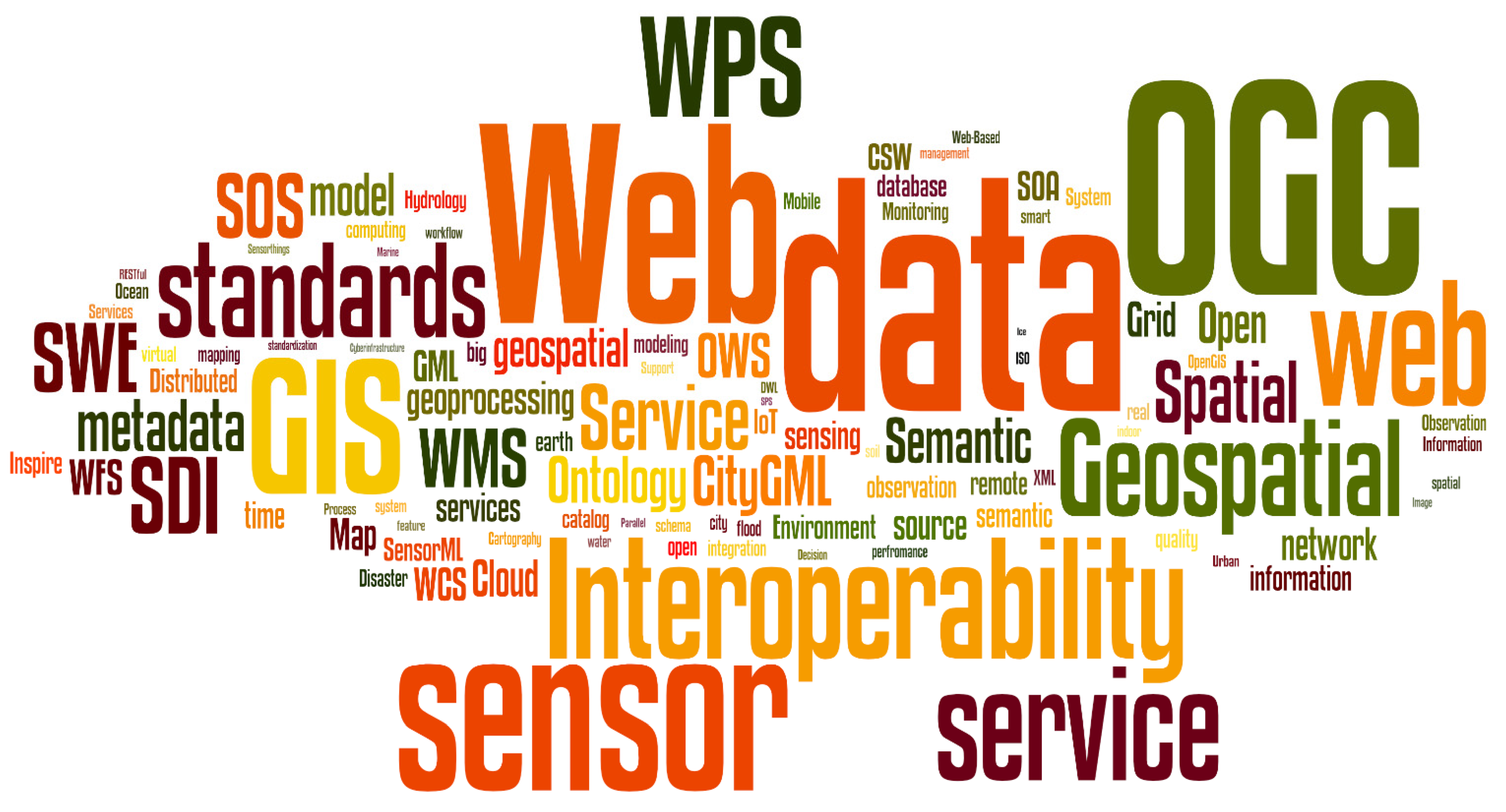
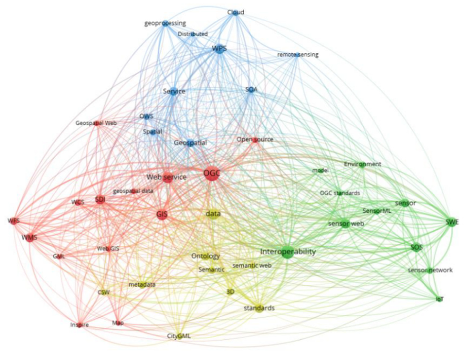
The uniform keywords were visualized by a word cloud analysis method. As shown in Figure 8, the keywords OGC, Web, Data, Interoperability, GIS, and sensor appeared more frequently, so their sizes are lager than others. The second most frequent keywords were service, standards, and some OGC specification names such as WPS, WMS, WFS, WCS, CityGML, OWS, SWE, SOS, SDI, GML, etc. The word cloud in Figure 8 shows that OGC specifications are adequate and do meet some needs for the GIS community as a “glue” by interoperating data, sensors, SDI, services, the Web, and users through the WPS, WMS, SOS, SWE, CityML, and other specifications.
Forty-four cleaned keywords appeared over 20 times for a total of 1989 occurrences, accounting for 47.33% of the total keywords. We conducted a co-occurrence cluster analysis on these 44 keywords with VosViewer, a visualization analysis tool. Co-occurrence keyword analysis is a method for analyzing the common presence and frequency of occurrence of keywords in the same paper to find the cluster of research topics. Table 6 shows the 44 cleaned keywords, and Figure 9 shows the result of the cluster analysis of co-occurrence keywords.
As shown in Figure 9, the diameter of a node represents the number of occurrences of the keywords. The bigger the node is, the more times the keywords occur. The line between two nodes indicates that the two keywords appear in the same article. The thicker the line is, the more times the two keywords appear together in the same article. The color of the nodes and the lines represent the different clusters we obtained. Four main clusters, OGC, WPS, Interoperability, and data, were formed. Four different color lines link their own cluster family separately.
In these four main clusters, the cluster of OGC with pink nodes and lines includes Web service, GIS, SDI (Spatial Data Infrastructure), WCS, WMS, WFS, GML, Web GIS, Geospatial Web, and Open source. The cluster of OGC focused mainly on the GIS environment, web services, and infrastructure.
The cluster of WPS with blue nodes and lines includes Service, metadata, OWS, Service-oriented architecture (SOA), Geospatial, Spatial, Cloud, geoprocessing, remote sensing, and distributed. The cluster of WPS focused mainly on the keywords of geospatial service processing.
The cluster of Interoperability with green nodes and lines includes SOS, SWE, sensor, SensorML, sensor web, sensor network, Internet of Things, OGC standards, model, environment, and so on. The cluster of Interoperability focused mainly on the topic of sensors and their web, working environment, and observation services.
The cluster of data with the yellow nodes and lines includes Ontology, Semantic, semantic web, 3D, standards, metadata, CSW, and CityGML. The cluster of data mainly focused on preparing data semantically and standardizing it.
The clusters presented in Figure 9 are similar to those presented in the OGC specification architecture in Figure 1. For example, in Figure 9, the cluster of Interoperability in green includes SWE, SOS, and sensor web as shown in the “sensor” level at the bottom of Figure 1. This fully demonstrates that the specifications mentioned in the WoS papers are consistent with the purpose of the OGC, that is, the quality is good.

3.6. Hotspot Research Analysis

By searching in the fields of the ‘title’, ‘abstract’, ‘keywords from the author’ and ‘keywords plus’, four OGC specifications (WPS, WMS, WFS, and SOS) were discussed in more than 100 papers; 21 OGC specifications were discussed in over ten papers; 14 OGC specifications were discussed in between three to nine papers; and 31 OGC specifications were discussed in fewer than three papers, shown in Table 7.
From Table 7, WPS was discussed most in publications, followed by the specifications of SOS, WMS, and WCS. Those OGC specifications are fundamental for enabling OGC Web Services, which can be published, located, and dynamically invoked across the Web, so that they can meet the needs from simple requests to complicated business processes. Anyone with a client application installed that supports these specifications can use maps and data through the Web. Furthermore, developers can create such supported client applications with the guidelines of the OGC specifications.
This bibliometric analysis reveals that there is still potential for OGC standards to develop, which was discussed less by the WoS articles, as Table 7 shows. Several were not even mentioned once. This may be because the specifications are sufficient, but there is also the possibility to develop deeper or further.

3.7. OGC Membership Analysis

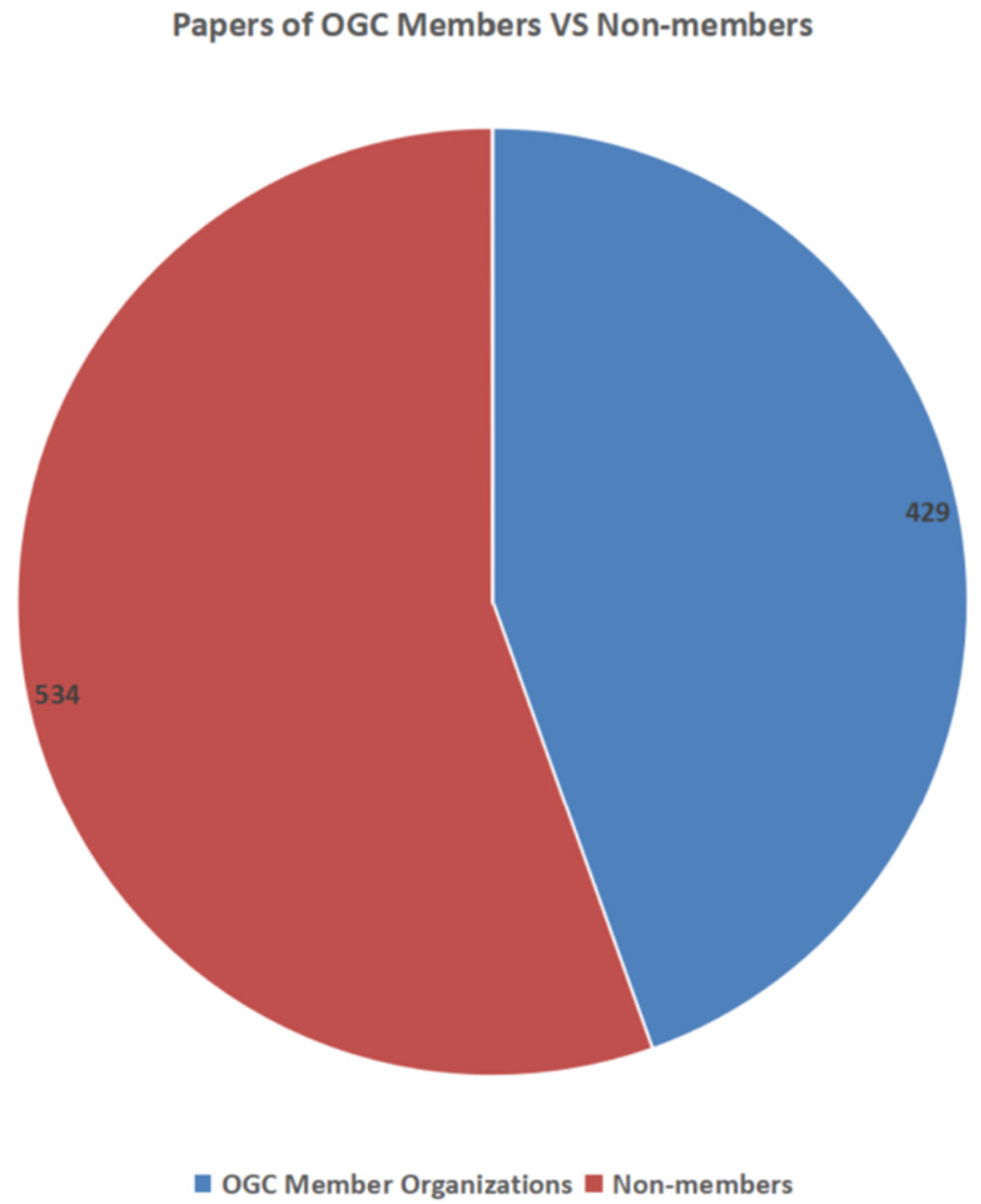
We carried out a set of OGC membership analyses to disclose which, when, how many, and by whom the OGC specifications were advanced and studied from 963 papers in our dataset. The first analysis is a comparison between the OGC members and non-members. By combining different spellings, we acquired 855 organizations from the Author’s Address (Organization only) fields that had 1742 organizations initially. We obtained 510 member organizations from the OGC website. We matched the two groups of organizations then found that members contributed almost half of the papers, as shown in Figure 10.
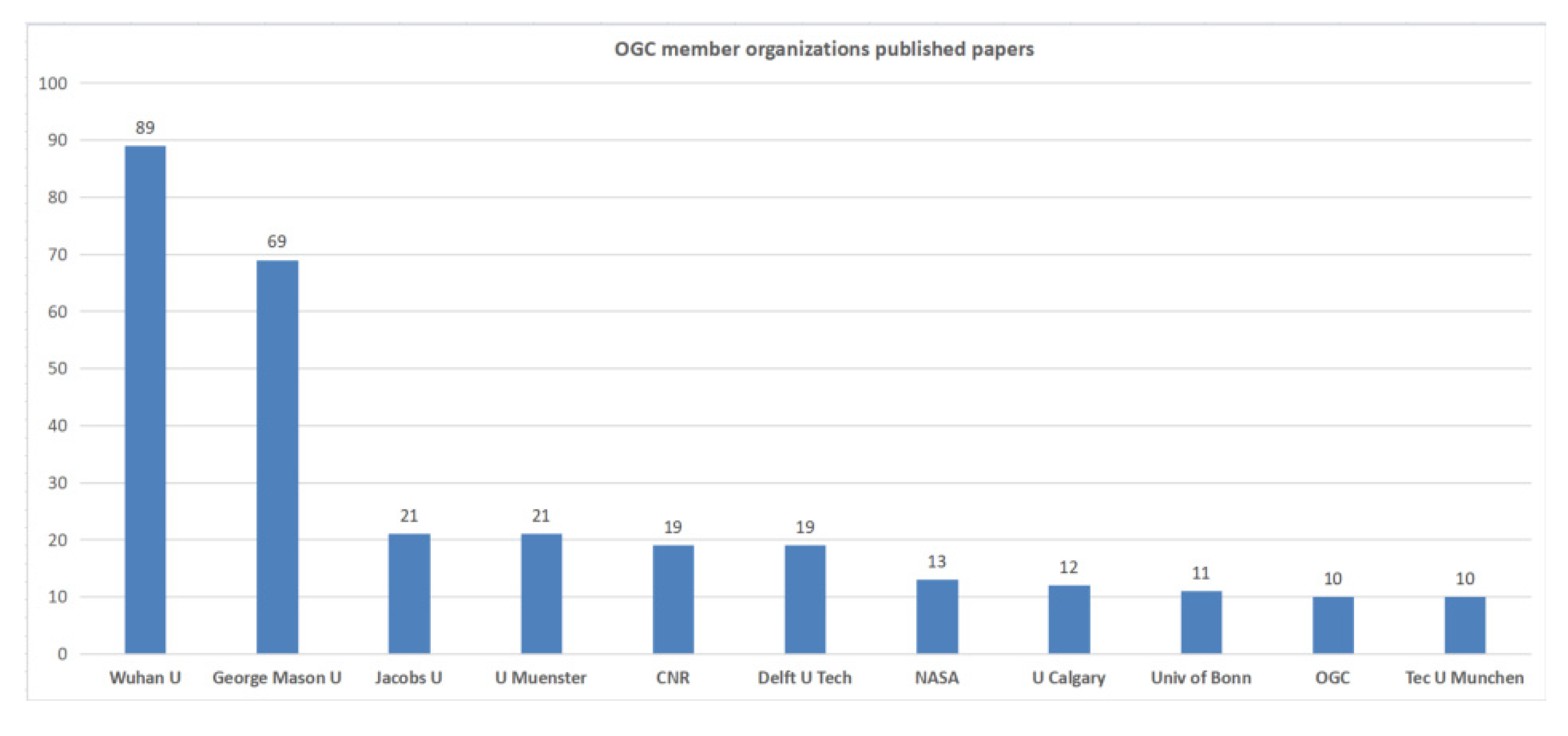
In the OGC membership group, we chose the organizations that published ten or more. Wuhan University and George Mason University published a total of 129 papers, which accounted for 30% of member contributions, shown in Figure 11.
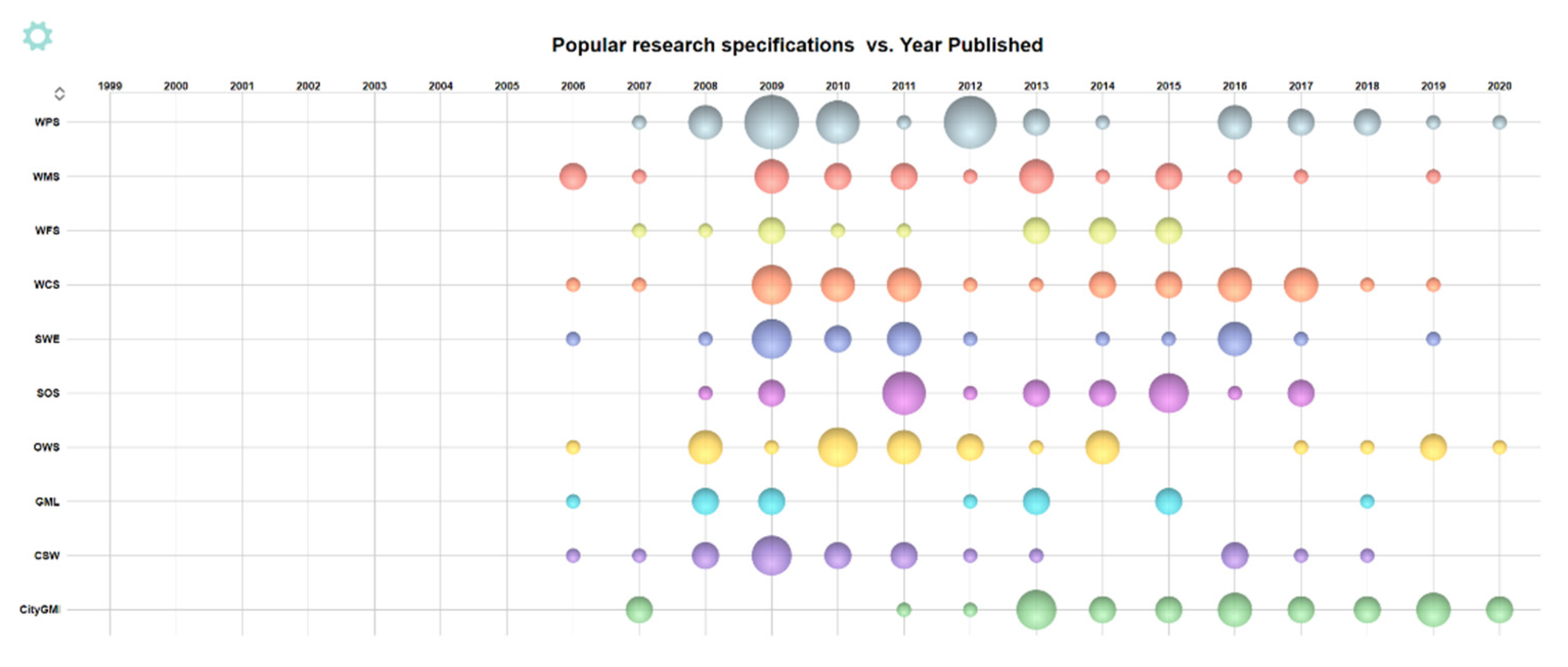
As mentioned earlier, the OGC standards have been extensively studied. Some were studied early and some were developed later in our study period. Figure 12 shows the age and number of high-profile OGC specifications. WMS, WCS, SWE, GML, and CSW emerged in 2006. WPS was highly focused between 2009 to 2012, while CityGML turn into a popular research topic sharply in 2013.
Among OGC specifications, some were studied or introduced by papers alone, though most came together. Figure 13 shows the connections among their co-occurrence. WCS, which was studied by 26 papers, had the most connections with other specifications. Sensor Web, OWS, and SOS also had very high frequency and was studied with others together.
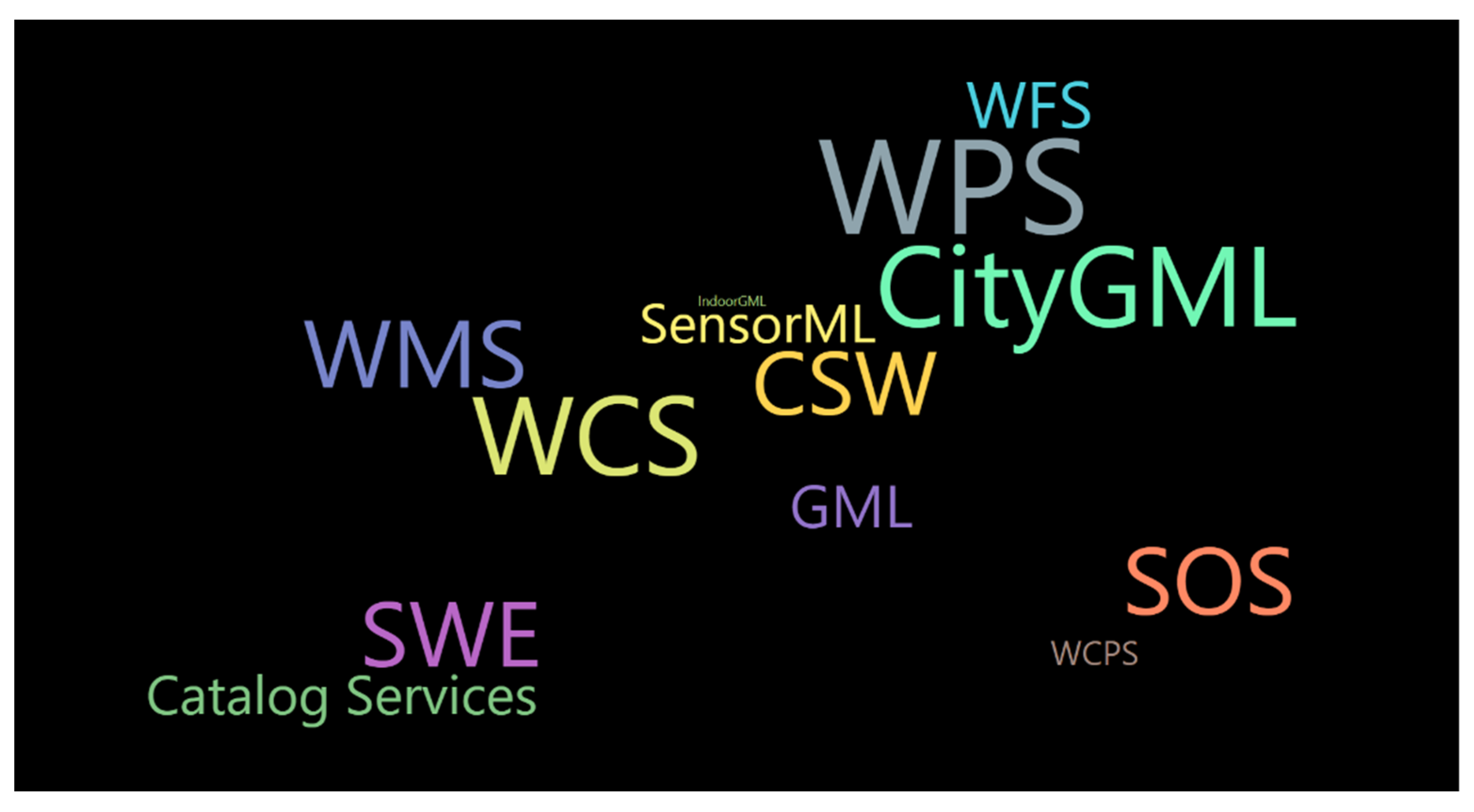
We chose the high frequency studied specifications from the OGC member organization papers and conduct a word cloud analysis with published 7 or more. Figure 14 shows the most popular research in a black background to distinguish the all dataset word analysis in Figure 8.

4. FAIR Analysis

Sound science increasingly relies on open research data. This is not only because scientific evidence represented by data will be essential for other research practices, but also because open data develops, combines, facilitates, and accelerates scientific discovery through the reuse of the data. FAIR Data Principles make data FAIR both for humans and machines, which is essential to scientific research [30]. To make data FAIR, the force comes from technology and policy [31]. The mission of OGC is to make geospatial data and services FAIR, and this section will illustrate how OGC has done this. In this section, we gained papers related to FAIR using keywords extraction in the literature dataset. Then, taking these papers as case studies, we analyzed the specifications related to F, A, I, R, respectively, and introduced how OGC specifications promote the data and services for the GIS field with the FAIR principle.

4.1. To Be Findable

According to the FAIR Data Principles, to be findable, data should have four principles:
  • F1. (meta)data are assigned a globally unique and eternally persistent identifier.
  • F2. data are described with rich metadata.
  • F3. (meta)data are registered or indexed in a searchable resource.
  • F4. metadata specify the data identifier.
See FAIR Data Principles at https://www.force11.org/group/fairgroup/fairprinciples, accessed on 4 October 2021.
These principles are concerned with identifying data/metadata and persistent identifiers of them. The findable geospatial resources (data/information/service/workflow) should have rich metadata to describe the data’s origins and histories such as who produced it, how it was produced, how many times and when it was changed or produced, and so on. Findable resources should also have a uniform resource locator (URL), which shall have a globally unique and persistent identifier, and the metadata or data should be registered or indexed in a searchable resource.
To find a sensor from its networks or services, ‘thematic’, ‘spatial’, ‘temporal’, ‘sensor properties’, ‘sensor identification’, ‘functionality’, and ‘usage restrictions’ will be the different ways for users to search. OGC SWE contains two parts of specifications for different functions, which work on a sensor web discovery solution. One part of OGC specifications works for the information model that includes ‘Observations and Measurements’, ‘Sensor Model Language/SensorML’, ‘SWE Common Data Model’, and ‘Transducer Markup Language’. The other part of OGC specifications works for the service model that includes ‘Sensor Observation Service’, ‘Sensor Alert Service Service’, ‘Sensor Planning Service’, and ‘Web Notification Service’. This was implemented and practically tested within the EU funded project “OSIRIS” [32].
To find a geospatial resource (data/information/service/workflow) in a quick and precise way, the WMS specification leverages geospatial web services. WMS was designed for defining raster images by providing a simple HTTP interface for requesting geo-registered map images from one or more distributed geospatial databases (https://www.opengeospatial.org/standards/wms, accessed on 4 October 2021), and it was found to be best suited for data handling and presentation [33]. To discover services and update the metadata, a method was introduced using a crawler by prioritizing crawling through a conditional probability model, by utilizing a multi-threading technique, and by updating the identified services metadata [34].
This study carried out a sub-topic trend analysis from 2018 to 2020 to find the recent sub-topics. The analysis found both emerging terms and no longer published terms. We chose the terms first used in the past three years, which concerned the two papers in Table 8. The result showed that data, data management, and CSW (concern to discovery) were no longer discussed by researchers. Meanwhile, Distributed GIS and Big Earth Data were first used. This indicates that the way geospatial information can be findable changed from data discovery to a more distributed means.

4.2. To Be Accessible

To be considered Accessible, data should have two principles of being retrievable:
  • A1 (meta)data are retrievable by their identifier using a standardized communications protocol.
  • A1.1 the protocol is open, free, and universally implementable.
  • 1.2 the protocol allows for an authentication and authorization procedure, where necessary.
These principles focus on the protocol that is an official description of the data format and the rules that must be followed when exchanging data between computers. There are different representations for the same concept, such as HTML, Turtle (TTL), and JSON-LD on the Web pages, which makes it more available for both human users and machines to access. OGC believes it would be better to be prepared for extended client needs. Therefore, OGC works in a web-friendly way by using an identifier (i.e., a URL) to get more information through, and user-friendly web pages and other forms of resource representations can be delivered via HTTP. Figure 15 shows different representations of the same content. All of these representations are accessible to different clients (https://www.opengeospatial.org/def-server, accessed on 29 August 2020).
To access sensor resources from the cloud, Ref. [35] presented two strategies that included data-centric and device-centric models separately, enabling the end-user to choose the type of cloud services that would be a Platform as a Service (PaaS) or a Software as a Service (SaaS). The data-centric model offered environmental data to its clients as a service by using the platform of the data without knowing about the data, such as how they were measured and processed. The device-centric model enabled the cloud clients to use software from the different monitoring infrastructures (MIs) while customizing for specific purposes by the clients. The OGC SWE specification was applied in the proposed solution, designed and conducted in Cloud4Sens, a cloud-based architecture to make acquiring, integrating, and managing heterogeneous sensing resources available from different MIs.
To get geospatial data from the increasingly developed Linked Open Data, an inherent spatial context of the data made by vocabularies and query languages were needed. Ref. [36] introduced how OGC WMS made glacier data from Global Land Ice Measurement from Space (GLIMS) available to other data servers. Battle, R. and Kolas, D. [37] presented a method through OGC GeoSPARQL, designed for unifying data access for the geospatial Semantic Web, for geospatial data access and indexing, and implemented it in the Parliament triple store.
The discussion on data accession has been enduring since 1999 when the first OGC paper was published. In this study, we extracted a total of 356 papers related to data accession, accounting for almost half of the total literature. The earliest papers mainly dealt with OGC specifications such as PUCK, Simple Features CORBA, WMS. The earlier papers introduced how to standardize the high-level software interfaces across disparate spatial data collections so the users might access the data [38]. Later in 2002, NASA HDF-EOS Web GIS Software Suite (NWGISS) provided the interoperable, personalized, on-demand data access and services (IPODAS) of remote sensing data [39]. In 2019, researchers proposed approaches for accessing geospatial data stored in relational databases using the OGC specification GeoSPARQL [40], as well as the approaches for accessing interpreted observations and analyses from the current platforms that are complex to access [41].

4.3. To Be Interoperable

To be interoperable, data should have three principles:
  • I1. (meta)data use a formal, accessible, shared, and broadly applicable language for knowledge representation.
  • I2. (meta)data use vocabularies that follow FAIR principles.
  • I3. (meta)data include qualified references to other (meta)data.
These principles focus on the working language and vocabulary for data interacting semantically from different platforms in common formats of the data/metadata. The community agreed-upon standards concern not only schemas, controlled vocabularies, keywords, and thesauri but also ontologies and broadly applicable language within various tools. OGC WPS is an interface specification for standardizing inputs and outputs (requests and responses) for geospatial processing services. OGC WPS works for clients by defining how they can request a process and by publishing how the output from their process will be handled. Through these processes, data required by clients for either delivering or operating can be available across a network or at the server.
To create an environmental system for dynamic physical, chemical, and biological processes at different spatial and temporal scales, software applications need to adapt to change at different scales and be able to have the capabilities for integrating models across transdisciplinary and organizational boundaries. Castronova, A. et al. [42] demonstrated a service-oriented approach allowing individual models to operate and to interact with other models by WPS. This approach included sharing model input and output files, rewriting models into a single software system, and establishing software architecture principles that can couple with other independent models. By implementing this method within the HydroModeler environment, it was proved that a hydrology model could be hosted as a WPS web service and used within a client-side workflow. These represented that, if following an established standard, the server-side software could be used and reused in multiple workflow environments and decision support systems.
To work with remote sensing imagery of agricultural fields, the challenge for users comes from large datasets, which make it difficult to manipulate archived datasets without access to public large-scale computing and storing capabilities. Sun, Z. et al. [43] demonstrated a solution for interoperating research resources in cyberinfrastructure by combining the OGC WCS specification and SOAP protocol. WCS is designed for users to process data coverages through an interoperable interface. SOAP is used to provide an XML-based, lightweight, and end-to-end information exchange protocol for the client in a distributed environment. The way that SOAP enables WCS for agricultural users’ timely retrieval of remote sensing imagery was implemented in an operational web system, Global Agricultural Drought Monitoring and Forecast System (GADMFS), proving its functionality.

4.4. To Be Reusable

To be reusable, data should have these four principle attributes:
  • R1. (meta)data have a plurality of accurate and relevant attributes.
  • R1.1. (meta)data are released with a clear and accessible data usage license.
  • R1.2. (meta)data are associated with their provenance.
  • R1.3. (meta)data meet domain-relevant community standards.
These principles concern the meta(data)’s attributes that may include:
(1)
License document: to make sure that data are accurate;
(2)
Provenance information: to show the data’s origin, and;
(3)
Certifications: to show data that have already met specific community standards.
In the Big Data era, the form taken by scientific output has gradually changed from mainly single outputs of scientific papers to a diverse variety of results such as scientific workflows, research protocols, standard operating procedures, algorithms for analysis, and/or data [44]. These results were mostly in digital form and expensive when they were produced. Therefore, as the research environment evolves into the Fourth Paradigm, that is, data-intensive scientific discovery, improved infrastructure is urgently needed to support the reuse of data, services, methods, and processes in scientific research [30].
To reuse existing geospatial data, having richly described attributes of metadata and/or data will be key for data stored by multiple providers in various formats on the different platforms operating with all kinds of software. Kiehle, C. [45] introduced service-oriented architectures to foster the reuse of existing geodata inventories in groundwater vulnerability assessment and mapping by using the OGC WPS Interoperability Experiment for defining interfaces, XML schemas, and sample applications. This method provided the public interfaces for getting capabilities, describing and executing the process of the service, which was implemented as a proof-of-concept for the provision of topological operators on the Internet.
To make data reusable, consideration for use should not only be given to ‘newborn’ digital data visible for other data sharing services but also previously published but otherwise unusable or invisible data. Codilean, A.T. et al. [46] provided the OCTOPUS, an open cosmogenic isotope and luminescence database for hosting and maintaining data and made them available to the research community. OCTOPUS is a hybrid database in which data are stored in two separate locations. The first is a PostGIS database with tabular data and the point and polygon geometries. The second is zip archives with all data (tabular, vector, and raster) and auxiliary information. Through a range of OGC specifications, including the widely used WFS, WMS, and KML, a variety of commonly used geospatial data formats have been produced including ESRI Shapefile, Google Earth, and ArcGIS data. Therefore, the client can export the data whether it is new or old.

5. Discussion

The results of this study can be an example for how OGC specifications serve geospatial data in a FAIR manner. However, this study has its limitations, as the database we chose was only one academic sample pool and did not include fields where OGC specifications are used more widely. The results can only reflect the application of OGC specifications in academic communities. It will be much more comprehensive for understanding the impacts of OGC specifications if we can also do further work to investigate the applications of OGC specifications in industries through the Delphi method, since industrial applications seldom publish papers.
Existing OGC specifications have already covered wide areas of geospatial technologies. However, demand for additional specifications remains. We summarized some, but the needs are not limited to these, as shown below:
(1)
to help interoperable systems develop operational services;
(2)
to improve data exchange between GIS and databases semantically and syntactically;
(3)
to help users know a project’s status and its workflow automatically;
(4)
to exchange vector symbols for interoperating conveniently;
(5)
to standardize 3D interfaces in multiple fields;
(6)
to use on other planets besides Earth.
In the future, as geographical data continues to explosively grow and the usage style changes, the current research results will be promising experiences for OGC to develop more specifications to meet such dynamically changing requirements.

6. Conclusions

This study reviewed papers from the Web of Science (WoS) Core Collection from 1994 to 2020 related to OGC specifications. A topic search strategy was used in WoS by searching for ‘OGC or (the individual specification names)’ and 963 papers were found. We conducted a bibliometric analysis of the yearly outputs, major countries and regions, core journals, organizations, research fields, keywords, and the most discussed OGC specifications. Our analysis revealed that the most productive year for OGC specification-related papers was 2009; the most productive source was the Proceeding of IGARSS with 51 papers; the most-cited journal was Computers & Geosciences with 613 citations, and the highest citations per paper were Geosensor Networks with 233 citations; the most productive country was the United States with 202 papers published and the most productive organization was Wuhan University with 89 papers; the most cited organization was George Mason University with 635 citations; the University of Munster had the highest citations per paper at 29.43. The OGC specifications have been used in multiple research and industrial fields. The most productive research field was Remote Sensing with 390 papers published and 2014 citations (the most citations out of all fields). The most frequently appeared keywords were Web, Data, Interoperability, GIS, and Sensor. The most highly discussed OGC Web Services were WPS, WMS, WFS, SOS, and SWE, with more than 100 papers published. Others with over 30 papers were WCS, CityGML, CS, GML, and SensorML from highest to lowest paper counts.
From the analysis, the OGC specifications were developed sufficiently and with quality. Further demands for additional specifications remain for helping interoperable systems develop operational services; improving data exchange semantically, syntactically, and conveniently; helping users know a project’s status and its workflow automatically; standardizing 3D interfaces in multiple fields; using on other planets besides Earth. Some OGC specifications such as GeoXACML, GUF, and OWS Security, were not discussed in any paper in this analysis. These unmentioned specifications might have been good enough that further study of them has not necessary, but they still could have been considered and developed further.
Furthermore, we looked for papers related to FAIR using keywords extraction in the literature dataset. We took these articles as case studies to analyze F, A, I, and R, respectively, to present how OGC specifications facilitate FAIR geospatial data. The FAIR Data Principles set the requirements on data to be principles-compliant while OGC specifications help geospatial data to meet the requirements. For example, to make geospatial data findable, OGC developed a set of geospatial data catalog protocols, such as OGC Catalog Service for Web (CSW), and OpenSearch; To make geospatial data accessible, OGC developed a set of interoperable geospatial data access specifications. The major ones include the WMS, WCS, and WFS specifications. To make geospatial data interoperable, OGC provides a systematic standard environment. All OGC specifications are designed with interoperability as one of the major objectives. The OGC specifications enable geospatial data interoperability from syntax levels to sematic/knowledge levels. To make geospatial data reusable, OGC defines metadata standards (which are identical to the ISO 19,115 series of standards), public interfaces, XML schemas, and sample applications for service-oriented architectures to foster the reuse of existing geodata.

Author Contributions

Conceptualization: Liping Di, Xiangtao Fan, Mingrui Huang, Hongdeng Jian and Liying Guo; Methodology, Formal Analysis, and Writing: Mingrui Huang; Visualization: Hongyue Zhang; Supervision: Liping Di. All authors have read and agreed to the published version of the manuscript.

Funding

This research was funded by the Strategic Priority Research Program of the Chinese Academy of Sciences, grant number XDA19080101; National Natural Science Foundation of China, grant number 41901328; China Scholarship Council, grant number 201804910116; Natural Science Foundation of Fujian Province, grant number 2021J011022.

Institutional Review Board Statement

Not applicable.

Informed Consent Statement

Informed consent was obtained from all subjects involved in the study.

Acknowledgments

Mingrui Huang was supported by a grant from the China Scholarship Council (grant number 201804910116) to conduct the research as a visiting scholar at Center for Spatial Information Science and Systems, George Mason University. The authors would like to thank Julia Di of Stanford University for editing and proofreading the manuscript and anonymous reviewers for their constructive comments on an earlier version of this paper.

Conflicts of Interest

The authors declare no conflict of interest. The funders had no role in the design of the study; in the collection, analyses, or interpretation of data; in the writing of the manuscript, or in the decision to publish the results.

Abbreviations

AbbreviationsList of acronyms
ABField name for Abstract in WoS
CPPA average number of Citations Per Paper
CSWCatalogue Service for the Web
DEField name for Author Keywords in WoS
FAIRFindable, Accessible, Interoperable, and Reusable
GMLGeography Markup Language
IDField name for Keywords Plus® in WoS
KG Knowledge Graph
NPNumber of Publications
OGCOpen Geospatial Consortium
OWSOGC Web Service
SDISpatial Data Infrastructure
SOSSensor Observation Service
SWESensor Web Enablement
TCTotal Citation Times
TIField name for Title in WoS
WCField name for WoS Category in WoS
WCSWeb Coverage Service
WFSWeb Feature Service
WMSWeb Map Service
WoSWeb of Science
WPSWeb Processing Service

References

  1. Reichardt, M.; Robida, F. Why Standards Matter–The Objectives and Roadmap of the International Open Geospatial Consortium (OGC); Annales des Mines—Responsabilité et Environnement: Paris, France, 2019; pp. 25–29. [Google Scholar] [CrossRef]
  2. Bröring, A.; Echterhoff, J.; Jirka, S.; Simonis, I.; Everding, T.; Stasch, C.; Liang, S.; Lemmens, R. New Generation Sensor Web Enablement. Sensors 2011, 11, 2652–2699. [Google Scholar] [CrossRef] [PubMed] [Green Version]
  3. Gröger, G.; Plümer, L. CityGML—Interoperable semantic 3D city models. ISPRS J. Photogramm. Remote Sens. 2012, 71, 12–33. [Google Scholar] [CrossRef]
  4. Boulos, M.N.K.; Resch, B.; Crowley, D.N.; Breslin, J.G.; Sohn, G.; Burtner, R.; Pike, W.A.; Jezierski, E.; Chuang, K.-Y.S. Crowdsourcing, citizen sensing and sensor web technologies for public and environmental health surveillance and crisis management: Trends, OGC standards and application examples. Int. J. Health Geogr. 2011, 10, 67. [Google Scholar] [CrossRef] [Green Version]
  5. Vitolo, C.; Elkhatib, Y.; Reusser, D.; Macleod, C.J.; Buytaert, W. Web technologies for environmental Big Data. Environ. Model. Softw. 2015, 63, 185–198. [Google Scholar] [CrossRef] [Green Version]
  6. Blaschke, T.; Hay, G.J.; Weng, Q.; Resch, B. Collective Sensing: Integrating Geospatial Technologies to Understand Urban Systems—An Overview. Remote Sens. 2011, 3, 1743–1776. [Google Scholar] [CrossRef] [Green Version]
  7. Deidda, M.; Pala, A.; Vacca, G. An example of a tourist location-based service (LBS) with open-source software. Appl. Geomatics 2013, 5, 73–86. [Google Scholar] [CrossRef]
  8. Tastan, B.; Aydinoglu, A.C. An approach for determining disaster risk as a part of national data models. Fresenius Environ. Bull. 2020, 29, 6–18. [Google Scholar]
  9. Pritchard, A. Statistical bibliography or bibliometrics. J. Doc. 1969, 25, 348. [Google Scholar]
  10. Zhuang, Y.; Du, C.; Zhang, L.; Du, Y.; Li, S. Research trends and hotspots in soil erosion from 1932 to 2013: A literature review. Scientometrics 2015, 105, 743–758. [Google Scholar] [CrossRef]
  11. Liu, F.; Lin, A.; Wang, H.; Peng, Y.; Hong, S. Global research trends of geographical information system from 1961 to 2010: A bibliometric analysis. Scientometrics 2016, 106, 751–768. [Google Scholar] [CrossRef]
  12. Xuemei, W.; Mingguo, M.; Xin, L.; Zhiqiang, Z. Applications and researches of geographic information system technologies in bibliometrics. Earth Sci. Inform. 2014, 7, 147–152. [Google Scholar] [CrossRef]
  13. Zhuang, Y.; Liu, X.; Nguyen, T.; He, Q.; Hong, S. Global remote sensing research trends during 1991–2010: A bibliometric analysis. Scientometrics 2013, 96, 203–219. [Google Scholar] [CrossRef]
  14. Li, L.; Liu, Y.; Zhu, H.; Ying, S.; Luo, Q.; Luo, H.; Kuai, X.; Xia, H.; Shen, H. A bibliometric and visual analysis of global geo-ontology research. Comput. Geosci. 2017, 99, 1–8. [Google Scholar] [CrossRef]
  15. Liang, J.M.; Gong, J.H.; Li, W.H. Applications and impacts of Google Earth: A decadal review (2006–2016). ISPRS J. Photogramm. Remote Sens. 2018, 146, 91–107. [Google Scholar] [CrossRef]
  16. Uman, L.S. Systematic reviews and meta-analyses. J. Can. Acad. Child Adolesc. Psychiatry 2011, 20, 57–59. [Google Scholar]
  17. Jacsó, P. The pros and cons of computing the h-index using Web of Science. Online Inf. Rev. 2008, 32, 673–688. [Google Scholar] [CrossRef]
  18. Chen, C. Science Mapping: A Systematic Review of the Literature. J. Data Inf. Sci. 2017, 2, 1–40. [Google Scholar] [CrossRef] [Green Version]
  19. Kahkonen, J.; Lehto, L.; Kilpeläinen, T.; Sarjakoski, T. Interactive visualisation of geographical objects on the Internet. Int. J. Geogr. Inf. Sci. 1999, 13, 429–438. [Google Scholar] [CrossRef]
  20. Rao, A.; Percivall, G.; Enloe, Y. Overview of the OGC catalog interface specification. In Proceedings of the IGARSS 2000—IEEE 2000 International Geoscience and Remote Sensing Symposium, Honolulu, HI, USA, 24–28 July 2000; Stein, T.I., Ed.; IEEE: New York, NY, USA, 2000; Volume I–Vi, pp. 1211–1213. [Google Scholar]
  21. Chen, N.; Di, L.; Yu, G.; Min, M. A flexible geospatial sensor observation service for diverse sensor data based on Web service. ISPRS J. Photogramm. Remote Sens. 2009, 64, 234–242. [Google Scholar] [CrossRef]
  22. Yue, P.; Gong, J.; Di, L.; He, L.; Wei, Y. Integrating semantic web technologies and geospatial catalog services for geospatial information discovery and processing in cyberinfrastructure. GeoInformatica 2011, 15, 273–303. [Google Scholar] [CrossRef]
  23. Zhang, J.Q.; Gong, J.; Lin, H.; Wang, G.; Huang, J.; Zhu, J.; Xu, B.; Teng, J. Design and development of Distributed Virtual Geographic Environment system based on web services. Inf. Sci. 2007, 177, 3968–3980. [Google Scholar] [CrossRef]
  24. Bradford, S.C. Sources of information on specific subjects. J. Inf. Sci. 1985, 10, 176–180, Reprinted from Eng. Illus. Wkly. J. 1934, 137, 85–86. [Google Scholar]
  25. Kim, D.-H.; Kim, M.-S. Web GIS service component based on open environment. In Proceedings of the IGARSS 2002: IEEE International Geoscience and Remote Sensing Symposium and 24th Canadian Symposium on Remote Sensing, Proceedings: Remote Sensing: Integrating Our View of the Planet, Toronto, ON, Canada, 24–28 June 2002; IEEE: New York, NY, USA, 2002; Volume I–Vi, pp. 3346–3348. [Google Scholar]
  26. Yue, P.; Di, L.; Zhao, P.; Yang, W.; Yu, G.; Wei, Y. Semantic Augmentations for Geospatial Catalogue Service. In Proceedings of the 2006 IEEE International Geoscience and Remote Sensing Symposium, Denver, CO, USA, 31 July–4 August 2006; IEEE: New York, NY, USA, 2006; Volume 1–8, pp. 3486–3489. [Google Scholar]
  27. Hu, C.; Chen, N.; Wang, C. Remote sensing satellite sensor information retrieval and visualization based on SensorML. In Proceedings of the 2011 IEEE International Geoscience and Remote Sensing Symposium, Vancouver, BC, Canada, 24–29 July 2011; IEEE: New York, NY, USA, 2011; pp. 3425–3428. [Google Scholar] [CrossRef]
  28. Sen, M.; Duffy, T. GeoSciML: Development of a generic GeoScience Markup Language. Comput. Geosci. 2005, 31, 1095–1103. [Google Scholar] [CrossRef] [Green Version]
  29. Horita, F.E.A.; de Albuquerque, J.P.; Degrossi, L.C.; Mendiondo, E.M.; Ueyama, J. Development of a spatial decision support system for flood risk management in Brazil that combines volunteered geographic information with wireless sensor networks. Comput. Geosci. 2015, 80, 84–94. [Google Scholar] [CrossRef]
  30. Wilkinson, M.D.; Dumontier, M.; Aalbersberg, I.J.; Appleton, G.; Axton, M.; Baak, A.; Blomberg, N.; Boiten, J.W.; da Silva Santos, L.B.; Bourne, P.E.; et al. Comment: The FAIR Guiding Principles for scientific data management and stewardship. Sci. Data 2016, 3, 160018. [Google Scholar] [CrossRef] [PubMed] [Green Version]
  31. Hodson, S.; Hodson, S.; Jones, S.; Collins, S.; Genova, F.; Harrower, N.; Laaksonen, L.; Mietchen, D.; Petrauskaité, R.; Wit-tenburg, P. Turning FAIR Data into Reality: Interim Report from the European Commission Expert Group on FAIR Data; Publications Office of the European Union: Luxembourg, 2018. [Google Scholar]
  32. Jirka, S.; Bröring, A.; Stasch, C. Discovery Mechanisms for the Sensor Web. Sensors 2009, 9, 2661–2681. [Google Scholar] [CrossRef] [PubMed] [Green Version]
  33. Tuama, É.Ó.; Hamre, T. Design and Implementation of a Distributed GIS Portal for Oil Spill and Harmful Algal Bloom Monitoring in the Marine Environment. Mar. Geod. 2007, 30, 145–168. [Google Scholar] [CrossRef]
  34. Li, W.W.; Yang, C.W.; Yang, C.J. An active crawler for discovering geospatial Web services and their distribution pattern—A case study of OGC Web Map Service. Int. J. Geogr. Inf. Sci. 2010, 24, 1127–1147. [Google Scholar] [CrossRef]
  35. Fazio, M.; Puliafito, A. Cloud4sens: A cloud-based architecture for sensor controlling and monitoring. IEEE Commun. Mag. 2015, 53, 41–47. [Google Scholar] [CrossRef]
  36. Raup, B.; Racoviteanu, A.; Khalsa, S.J.S.; Helm, C.; Armstrong, R.; Arnaud, Y. The GLIMS geospatial glacier database: A new tool for studying glacier change. Glob. Planet. Chang. 2007, 56, 101–110. [Google Scholar] [CrossRef]
  37. Battle, R.; Kolas, D. Enabling the geospatial Semantic Web with Parliament and GeoSPARQL. Semant. Web 2012, 3, 355–370. [Google Scholar] [CrossRef]
  38. Nebert, D. Interoperable spatial data catalogs. Photogramm. Eng. Remote Sens. 1999, 65, 573–575. [Google Scholar]
  39. Di, L.P.; Yang, W.; Deng, M.; Deng, D.; McDonald, K. Interoperable access of remote sensing data through NWGISS. In Proceedings of the IGARSS 2002: IEEE International Geoscience and Remote Sensing Symposium and 24th Canadian Symposium on Remote Sensing, Proceedings: Remote Sensing: Integrating Our View of the Planet, Toronto, ON, Canada, 24–28 June 2002; IEEE: New York, NY, USA, 2002; Volume I–Vi, pp. 255–257. [Google Scholar]
  40. Bereta, K.; Xiao, G.; Koubarakis, M. Ontop-spatial: Ontop of geospatial databases. J. Web Semant. 2019, 58, 100514. [Google Scholar] [CrossRef]
  41. Chung, C.C.; Huang, C.-Y.; Guan, C.-R.; Jian, J.-H. Applying OGC Sensor Web Enablement Standards to Develop a TDR Multi-Functional Measurement Model. Sensors 2019, 19, 4070. [Google Scholar] [CrossRef] [Green Version]
  42. Castronova, A.; Goodall, J.; Elag, M.M. Models as web services using the Open Geospatial Consortium (OGC) Web Processing Service (WPS) standard. Environ. Model. Softw. 2013, 41, 72–83. [Google Scholar] [CrossRef]
  43. Sun, Z.; Di, L.; Zhang, C.; Lin, L.; Fang, H.; Tan, X.; Yue, P. Combining OGC WCS with SOAP to faciliate the retrieval of remote sensing imagery about agricultural fields. In Proceedings of the 2016 Fifth International Conference on Agro-Geoinformatics (Agro-Geoinformatics), Tianjin, China, 18–20 July 2016; IEEE: New York, NY, USA, 2016; pp. 1–4. [Google Scholar]
  44. Bechhofer, S.; De Roure, D.; Gamble, M.; Goble, C.; Buchan, I. Research Objects: Towards Exchange and Reuse of Digital Knowledge. Nat. Preced. 2010. [Google Scholar] [CrossRef]
  45. Kiehle, C. Business logic for geoprocessing of distributed geodata. Comput. Geosci. 2006, 32, 1746–1757. [Google Scholar] [CrossRef]
  46. Codilean, A.T.; Munack, H.; Cohen, T.J.; Saktura, W.M.; Gray, A.; Mudd, S.M. OCTOPUS: An open cosmogenic isotope and luminescence database. Earth Syst. Sci. Data 2018, 10, 2123–2139. [Google Scholar] [CrossRef] [Green Version]
Figure 1. Functional architecture of OGC implementation specifications.
Ijgi 11 00251 g001
Figure 2. How OGC specifications facilitate FAIR geospatial data.
Ijgi 11 00251 g002
Figure 3. Data acquisition, processing, and analysis process.
Ijgi 11 00251 g003
Figure 4. Number of Publications (NP) between 1999 and 2020.
Ijgi 11 00251 g004
Figure 5. Number of Publications (NP) produced by the most prolific countries and regions.
Ijgi 11 00251 g005
Figure 6. Twelve productive organizations that published more than ten OGC specification-related papers in WoS.
Ijgi 11 00251 g006
Figure 7. The collaborative relationships among the organizations that published more than five papers.
Ijgi 11 00251 g007
Figure 8. The word cloud figure shows the most common keywords in this OGC literature analysis.
Ijgi 11 00251 g008
Figure 9. Clusters of the 44 uniformized keywords with more than 20 co-occurrences.
Ijgi 11 00251 g009
Figure 10. Papers published by OGC members and non-members.
Ijgi 11 00251 g010
Figure 11. Eleven productive OGC member organizations.
Ijgi 11 00251 g011
Figure 12. Age and publication count of popular OGC specifications.
Ijgi 11 00251 g012
Figure 13. Connections among the co-occurrences of OGC specifications.
Ijgi 11 00251 g013
Figure 14. The most popular specifications in the OGC member organization papers.
Ijgi 11 00251 g014
Figure 15. Various representations such as HTML (left), TTL (middle), and JSON (right) for the same content. (Source: https://www.opengeospatial.org/def-server, accessed on 29 August 2020).
Ijgi 11 00251 g015
Table 1. Bibliometric analysis of core journals according to Bradford’s Law.
ABCDEF
Publication Count
(478 Total)
Papers per Publication
(963 Total)
Cumulative Sum of Papers in PublicationsZonePapers in Each ZonePublications in Each Zone
13434
13165
418137
217171
116187
112199131223
311232
110242
39269
18277
57312
46336
55361
1244092307111
303499
602619
34419633344344
Table 2. The 23 core journals for OGC specification research in WoS.
No.Core PublicationsNumber of Papers
1.Isprs International Journal Of Geo-Information34
2.Computers & Geosciences31
3.2009 17th International Conference On Geoinformatics, Vols 1 And 218
4.Environmental Modelling & Software18
5.International Journal Of Digital Earth18
6.Sensors18
7.International Journal Of Geographical Information Science17
8.Transactions In Gis17
9.Webmgs 2010: 1st International Workshop On Pervasive Web Mapping, Geoprocessing And Services16
10.Ieee Journal Of Selected Topics In Applied Earth Observations And Remote Sensing12
11.Computers Environment And Urban Systems11
12.International Journal Of Spatial Data Infrastructures Research11
13.Remote Sensing11
14.18th World Imacs Congress And Modsim09 International Congress On Modelling And Simulation: Interfacing Modelling And Simulation With Mathematical And Computational Sciences10
15.Applied Geomatics9
16.Geo-Spatial Information Science9
17.Xxiii Isprs Congress, Commission Iv9
18.Web And Wireless Geographical Information Systems, Proceedings8
19.2006 Ieee International Geoscience And Remote Sensing Symposium, Vols 1–87
20.2010 18th International Conference On Geoinformatics7
21.Korean Journal Of Remote Sensing7
22.Oceans 2009, Vols 1–37
23.Urban And Regional Data Management7
Table 3. Twenty-three publications with more than 50 citations of OGC specification literature. Sorted by TC in reverse order.
No.Name of PublicationTCNPCPP_Journal
1.Computers & Geosciences6133119.77
2.Sensors5131828.50
3.Environmental Modelling & Software4151823.06
4.International Journal Of Geographical Information Science3421720.12
5.Computers Environment And Urban Systems3191129.00
6.Isprs Journal Of Photogrammetry And Remote Sensing292397.33
7.International Journal Of Health Geographics252384.00
8.Geosensor Networks2231223.00
9.Isprs International Journal Of Geo-Information207346.09
10.International Journal Of Digital Earth1861810.33
11.Ieee Journal Of Selected Topics In Applied Earth Observations And Remote Sensing1821215.17
12.Global And Planetary Change1781178.00
13.Transactions In Gis1741710.24
14.Semantic Web142347.33
15.Geoinformatica140528.00
16.Remote Sensing1401112.73
17.Web And Wireless Geographical Information Systems98118.91
18.Proceedings Of The 2009 International Symposium On Collaborative Technologies And Systems85421.25
19.Igarss83511.63
20.Urban And Regional Data Management6379.00
21.Ecological Informatics62231.00
22.International Journal Of Applied Earth Observation And Geoinformation55227.50
23.International Journal Of Spatial Data Infrastructures Research54114.91
Table 4. Eight WC in which each published over 100 OGC specification-related papers in WoS.
No.Name of PublicationsNPTCCPP_WC
1.Remote Sensing39020145.16
2.Computer Science, Information Systems23011795.13
3.Geography, Physical22718228.03
4.Engineering, Electrical & Electronic18410835.89
5.Geosciences, Multidisciplinary17615748.94
6.Computer Science, Interdisciplinary Applications153168711.03
7.Imaging Science & Photographic Technology1246925.58
8.Computer Science, Theory & Methods1087747.17
Table 5. Two semantic disambiguation examples of uniformized keywords, which represent the same meaning but in different spelling forms.
Uniformized KeywordsRaw Keywords
OGC Web Processing Service
OGC WPS 2.0
OGC WPS
Open Geospatial Consortium Web Processing Service
Web Processing Service
Web Processing Service 2.0
WPSWeb processing service (WPS)
web processing service client
web processing service
Web Processing Service: Geospatial Processing Web
Web processing services (WPS)
Web Processing Services
Web-Processing Service (WPS)
WPS 1.0
WPS 2.0
(Open Geospatial Consortium) (R)
open geospatial consortium (OGC)
OGCOpen Geospatial Consortium (OGC)
open geospatial consortium
Open geospatial consortium, OGC
Open geospatial standards (OGC)
Table 6. Forty-four uniformized keywords with more than 20 co-occurrences.
Uniformized Keywords Co-Occurrence over 20 TimesFrequency of Co-Occurrences (Times)Uniformized Keywords Co-Occurrence over 20 TimesFrequency of Co-Occurrences (Times)
1.  OGC15123.  Cloud32
2.  Interoperability10924.  WFS32
3.  data10525.  geoprocessing30
4.  Web service9226.  WCS29
5.  WPS9127.  Geospatial Web28
6.  GIS8528.  GML28
7.  SDI6929.  Open source28
8.  SWE6230.  Map28
9.  sensor web6231.  SOA27
10.  standards5732.  Spatial27
11.  SOS5633.  Web GIS26
12.  Service5334.  sensor network25
13.  WMS5335.  CSW24
14.  Geospatial5236.  Environment22
15.  sensor4937.  IoT22
16.  metadata4638.  semantic web22
17.  CityGML4539.  OGC standards21
18.  3D4440.  SensorML21
19.  Ontology4241.  model21
20.  OWS4042.  Distributed21
21.  Semantic3843.  Inspire20
22.  geospatial data3444.  remote sensing20
Table 7. Services of the OGC specifications and related publications in WoS.
OGC SpecificationsNPOGC SpecificationsNP
1.  Web Processing Service (WPS)16034.  WaterML5
2.  Web Map Service (WMS)14635.  WKT CRS5
3.  Web Feature Service (WFS)11736.  Coordinate Transformation4
4.  SWE Service Model11337.  LAS4
5.  Sensor Observation Service (SOS)11138.  Open GeoSMS4
6.  OWS Context10539.  PipelineML4
7.  Sensor Web Enablement (SWE) *10140.  3D Tiles3
8.  CityGML7941.  GeoPackage3
9.  Web Coverage Service (WCS)7542.  3dP2
10.  Geography Markup Language (GML)7343.  GML in JPEG 20002
11.  Catalogue Service2944.  Moving Features2
12.  Sensor Model Language2545.  Observations and Measurements2
13.  Sensor Planning Service (SPS)2046.  SensorThings2
14.  KML1847.  ARML2.01
15.  NetCDF1848.  CDB1
16.  Simple Features SQL1749.  Filter Encoding1
17.  GeoAPI1550.  GeoRSS1
18.  GeoSPARQL1551.  GeoTiff1
19.  SWE Common Data Model1552.  i3s1
20.  Simple Features1553.  LandInfra/InfraGML1
21.  Web Coverage Processing Service (WCPS)1554.  Simple Features OLE/COM1
22.  IndoorGML1455.  Table Joining Service1
23.  OGC API-Features1456.  Two Dimensional Tile Matrix Set1
24.  Styled Layer Descriptor1457.  Web Map Context1
25.  Cat: ebRIM App Profile: Earth Observation Products1058.  Geospatial eXtensible Access Control Markup Language (GeoXACML)0
26.  PUCK959.  Geospatial User Feedback (GUF)0
27.  Web Map Tile Service (WMTS)960.  GroundwaterML0
28.  Ordering Services Framework for Earth Observation Products861.  OpenSearch for EO0
29.  Symbology Encoding762.  OpenSearch Geo0
30.  GeoSciML663.  OWS Security0
31.  OpenMI664.  PubSub0
32.  Location Services (OpenLS)565.  TimeseriesML (tsml)0
33.  Simple Features CORBA566.  Web Service Common0
* Note: We created a new line of Sensor Web Enablement (SWE) (#7 in this table) so we have one more standard than the 65 standards on the OGC website. The record number of SWE includes the SWE Service Model (#4) and SWE Common Data Model (#19) because most keywords of articles only mentioned the SWE while we could not tell whether it was from #4 or #19.
Table 8. Sub-topic trends in the past three years.
Terms First Used in the Past Three YearsTerms No Longer Published in the Past Three Years
Distributed GIS [2]Web Feature Service (WFS) [32]
Black Sea [2]service oriented architecture [22]
single sign-on [2]data [14]
two-level modeling [2]service chain [13]
Contaminants [2]Grid computing [12]
LIDAR [2]sensor networks [12]
OAuth2 [2]SERVICES [11]
Participatory GIS [2]Xml [11]
3D DIGITAL ARCHIVE [2]CSW [11]
actuators [2]Disaster management [8]
archetypes [2]Internet/Web [8]
big Earth data [2]data management [7]
Publisher’s Note: MDPI stays neutral with regard to jurisdictional claims in published maps and institutional affiliations.

