You are currently viewing a new version of our website. To view the old version click .

ISPRS International Journal of Geo-Information, Volume 7, Issue 11

November 2018 - 39 articles

Cover Story: 
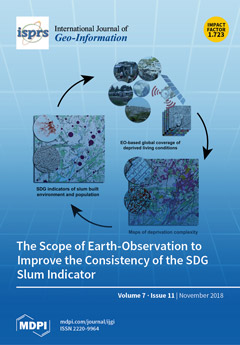
The increase in deprived living conditions in many cities of the Global South contradicts efforts to make them inclusive, safe, resilient, and sustainable places. Global statistics on the “proportion of urban population living in slums, informal settlements, or inadequate housing” (SDG indicator 11.1.1) are highly uncertain due to measurement and reporting problems. In addition, the data cannot be localized to effectively support upgrading. Using examples from across the globe, we show the scope of earth observation-based mapping of deprived living conditions and related population estimations in support of providing consistent information for the SDG indicator 11.1.1, and address uncertainties and geo-ethics. View this paper.
  • Issues are regarded as officially published after their release is announced to the table of contents alert mailing list .
  • You may sign up for email alerts to receive table of contents of newly released issues.
  • PDF is the official format for papers published in both, html and pdf forms. To view the papers in pdf format, click on the "PDF Full-text" link, and use the free Adobe Reader to open them.

Articles (39)

  • Article
  • Open Access
12 Citations
4,218 Views
14 Pages

Land surface phenology (LSP) is a sensitive indicator of climate change. Understanding the variation in LSP under various impacts can improve our knowledge on ecosystem dynamics and biosphere-atmosphere interactions. Over recent decades, LSP derived...

  • Article
  • Open Access
41 Citations
15,654 Views
26 Pages

Place versus Space: From Points, Lines and Polygons in GIS to Place-Based Representations Reflecting Language and Culture

  • Thomas Blaschke,
  • Helena Merschdorf,
  • Pablo Cabrera-Barona,
  • Song Gao,
  • Emmanuel Papadakis and
  • Anna Kovacs-Györi

Around the globe, Geographic Information Systems (GISs) are well established in the daily workflow of authorities, businesses and non-profit organisations. GIS can effectively handle spatial entities and offer sophisticated analysis and modelling fun...

  • Article
  • Open Access
3,360 Views
23 Pages

Real-Time Efficient Exploration in Unknown Dynamic Environments Using MAVs

  • Haytham Mohamed,
  • Adel Moussa,
  • Mohamed Elhabiby and
  • Naser El-Sheimy

Micro aerial vehicles (MAVs) have been acknowledged as an influential technology for indoor search and rescue operations. The time constraint is a crucial factor in most search and rescue operations. The employed MAVs in indoor environments are chara...

  • Article
  • Open Access
16 Citations
5,915 Views
13 Pages

Estimation of Hourly Link Population and Flow Directions from Mobile CDR

  • Ko Ko Lwin,
  • Yoshihide Sekimoto and
  • Wataru Takeuchi

The rise in big data applications in urban planning and transport management is now widening and becoming a part of local government decision-making processes. Understanding people flow inside the city helps urban and transport planners build a healt...

  • Article
  • Open Access
8 Citations
5,013 Views
16 Pages

Toward Model-Generated Household Listing in Low- and Middle-Income Countries Using Deep Learning

  • Robert Chew,
  • Kasey Jones,
  • Jennifer Unangst,
  • James Cajka,
  • Justine Allpress,
  • Safaa Amer and
  • Karol Krotki

While governments, researchers, and NGOs are exploring ways to leverage big data sources for sustainable development, household surveys are still a critical source of information for dozens of the 232 indicators for the Sustainable Development Goals...

  • Article
  • Open Access
5 Citations
4,723 Views
18 Pages

Web applications in spatial data infrastructures (SDIs) should provide robust and user-friendly user interfaces for geoinformation (GI) discovery, analysis, and usage. Poor usability, e.g., caused by unsuitable information presentation or inappropria...

  • Article
  • Open Access
15 Citations
5,899 Views
22 Pages

New planning tools are required to depict the complete building stock in a city and investigate detailed measures on reaching local and global targets to improve energy efficiency and reduce greenhouse gas emissions. To pursue this objective, ISO (th...

  • Article
  • Open Access
17 Citations
6,565 Views
15 Pages

Effective Identification of Terrain Positions from Gridded DEM Data Using Multimodal Classification Integration

  • Ling Jiang,
  • Dequan Ling,
  • Mingwei Zhao,
  • Chun Wang,
  • Qiuhua Liang and
  • Kai Liu

Terrain positions are widely used to describe the Earth’s topographic features and play an important role in the studies of landform evolution, soil erosion and hydrological modeling. This work develops a new multimodal classification system wi...

  • Article
  • Open Access
61 Citations
10,485 Views
22 Pages

Multi-Criteria Decision Making (MCDM) Model for Seismic Vulnerability Assessment (SVA) of Urban Residential Buildings

  • Mohsen Alizadeh,
  • Mazlan Hashim,
  • Esmaeil Alizadeh,
  • Himan Shahabi,
  • Mohammad Reza Karami,
  • Amin Beiranvand Pour,
  • Biswajeet Pradhan and
  • Hassan Zabihi

Earthquakes are among the most catastrophic natural geo-hazards worldwide and endanger numerous lives annually. Therefore, it is vital to evaluate seismic vulnerability beforehand to decrease future fatalities. The aim of this research is to assess t...

  • Article
  • Open Access
33 Citations
6,568 Views
16 Pages

Species-Level Vegetation Mapping in a Himalayan Treeline Ecotone Using Unmanned Aerial System (UAS) Imagery

  • Niti B. Mishra,
  • Kumar P. Mainali,
  • Bharat B. Shrestha,
  • Jackson Radenz and
  • Debendra Karki

Understanding ecological patterns and response to climate change requires unbiased data on species distribution. This can be challenging, especially in biodiverse but extreme environments like the Himalaya. This study presents the results of the firs...

of 4

Get Alerted

Add your email address to receive forthcoming issues of this journal.

XFacebookLinkedIn
ISPRS Int. J. Geo-Inf. - ISSN 2220-9964