

Geosciences, Volume 14, Issue 5 (May 2024) – 28 articles
Cover Story (view full-size image):
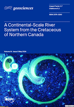
The yellow-green luminescence of fossil gastropod shells in a siderite concretion in the Early Cretaceous McMurray Formation of northern Alberta Canada shows that the crossed-lamellar microstructure of the nacreous layer of these shells retains the original aragonite mineralogy. The exceptional preservation of these fossil shells and associated authigenic carbonates allows for stable isotopic characterization of the ancient river system that deposited the sediments of this part of the McMurray Formation. The results indicate that the drainage basin of this river system extended over much of the North American continent during the Early Cretaceous. This conclusion is compatible with results from other studies on sediment routing during deposition of the McMurray Formation. View this paper
- Issues are regarded as officially published after their release is announced to the table of contents alert mailing list.
- You may sign up for e-mail alerts to receive table of contents of newly released issues.
- PDF is the official format for papers published in both, html and pdf forms. To view the papers in pdf format, click on the "PDF Full-text" link, and use the free Adobe Reader to open them.
Previous Issue
Next Issue