


Abstract
This work deals with the quantification of long-term fault slip rates as a basis for seismic hazard assessment along a segment of the Eastern Messinia Fault Zone (EMFZ) in southwestern Peloponnese, Greece. Using cosmogenic 36Cl exposure dating, it provides independent numerical constraints on recent deformation. The resulting late Holocene slip-rate estimates (~0.32–0.46 mm/yr) confirm ongoing fault activity, consistent with earlier paleoseismological and geomorphic studies, while indicating spatially distributed extension. These rates imply loading timescales of several hundred years for moderate (Mw ≈ 5.8–6.0) earthquakes. Although individual exposure ages cannot be uniquely associated with single seismic events, they offer robust benchmarks for cumulative displacement and long-term strain accumulation. Overall, this work demonstrates how numerical dating methods (particularly cosmogenic nuclide techniques applied to carbonate bedrock) can link geological observations with engineering requirements by constraining fault behavior over 103–105 year timescales and improving long-term seismic hazard evaluation in complex tectonic settings.
1. Introduction
Modern infrastructure frequently intersects or lies in close proximity to active faults. The key question for engineers is not how old a fault is but how frequently it moves, that is, its slip rate. Understanding fault behavior over the past several tens of thousands of years (the paleoseismic window) is therefore essential for estimating maximum credible earthquakes, determining recurrence intervals, and assessing long-term displacement rates that could threaten infrastructure.
To quantify these parameters, numerical ages for the most recent faulting events are required [1]. This is where geological dating methods enter the engineering domain. Numerical dating techniques such as radiocarbon (14C), optically stimulated luminescence (OSL), and cosmogenic nuclide dating can be applied to infrastructure-related hazard assessment and monitoring, particularly where infrastructure interacts with faulted rock, spoil heaps, or rockfalls. These methods are especially valuable for constraining slip near large, safety-critical structures [2] such as dams, tunnels, nuclear facilities, highways, and pipelines. However, despite their potential, the number of published case studies designed specifically for these purposes remains limited [3,4,5,6]. And here is where numerical dating methods like radiocarbon, OSL, and cosmogenic nuclide dating become directly relevant, even for modern engineering.
Surface ruptures have been identified for several normal-faulting earthquakes in the Aegean region [7], but for most historical earthquakes, the associated faults remain unknown [8]. This limitation hampers efforts to use correlations between ancient structural destruction and fault activity [9,10,11,12] as models for modern hazard assessment. Understanding fault behavior over the last few tens of thousands of years (the paleoseismic window) is critical for estimating at least long-term slip rates.
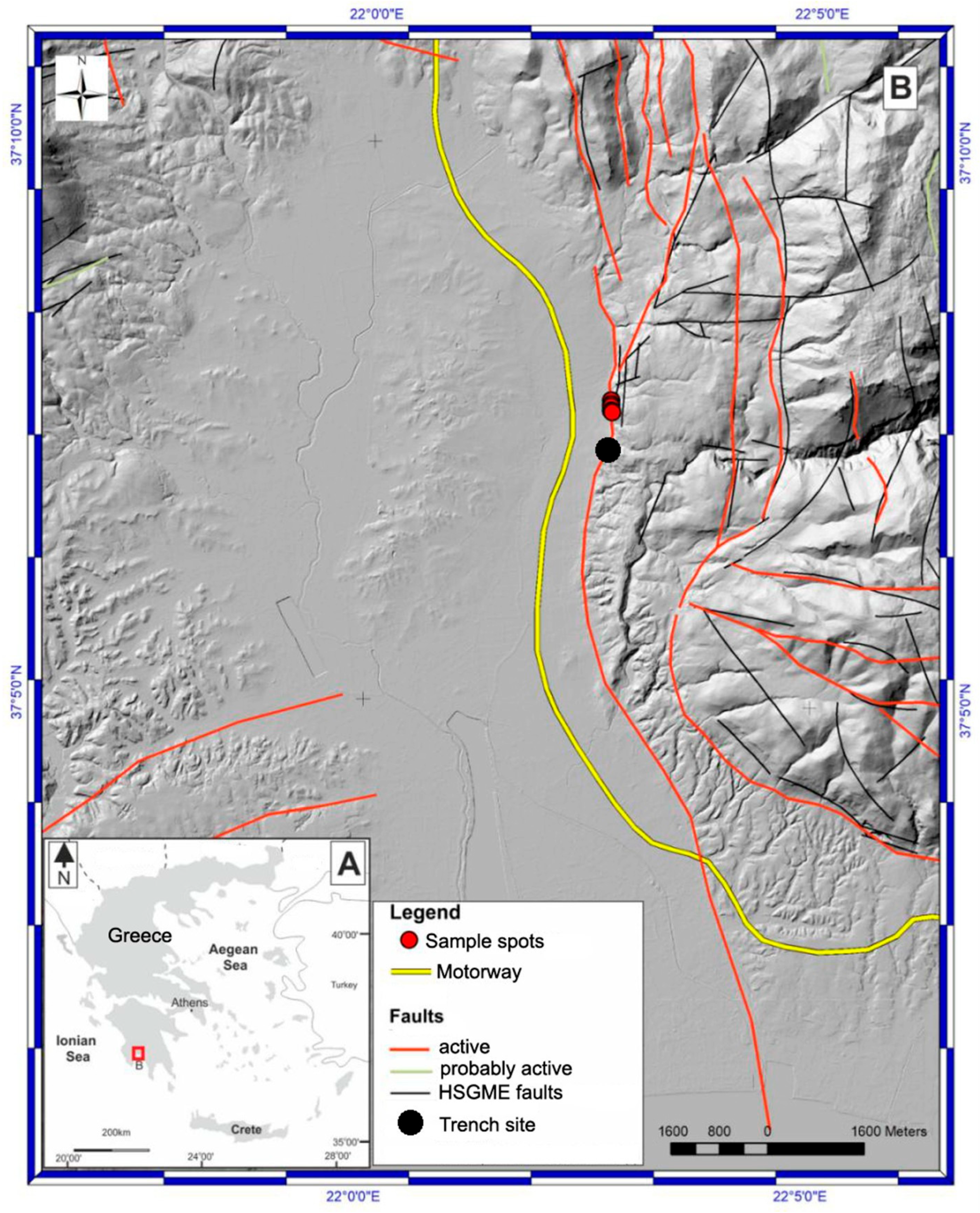
Located near the Hellenic Trench, where the African Plate descends beneath the Aegean microplate, the southwestern Peloponnese (Greece) (Figure 1) ranks among the most tectonically and seismically active sectors of the Hellenic Arc. This geodynamic setting generates intense crustal deformation and periodic release of accumulated elastic strain through seismic slip on major fault systems [13,14,15,16,17,18,19,20,21,22,23,24].
Figure 1.
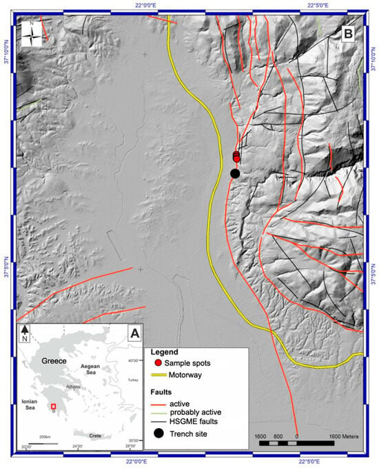
(A) location of study area. (B) Relief map and fault pattern along a segment of the Eastern Messinia Fault Zone (EMFZ). The study area is indicated by the cluster of red dots representing sampling locations. The digital elevation model (DEM) is sourced from the Hellenic Cadastre. Active and potentially active faults are shown based on the AFG database [7], while faults depicted in black are in superposition and extracted from the 1:50,000-scale geological map of the Hellenic Survey of Geology and Mineral Exploration (HSGME), Kalamata sheet. The trench site investigated by [25] is also indicated.
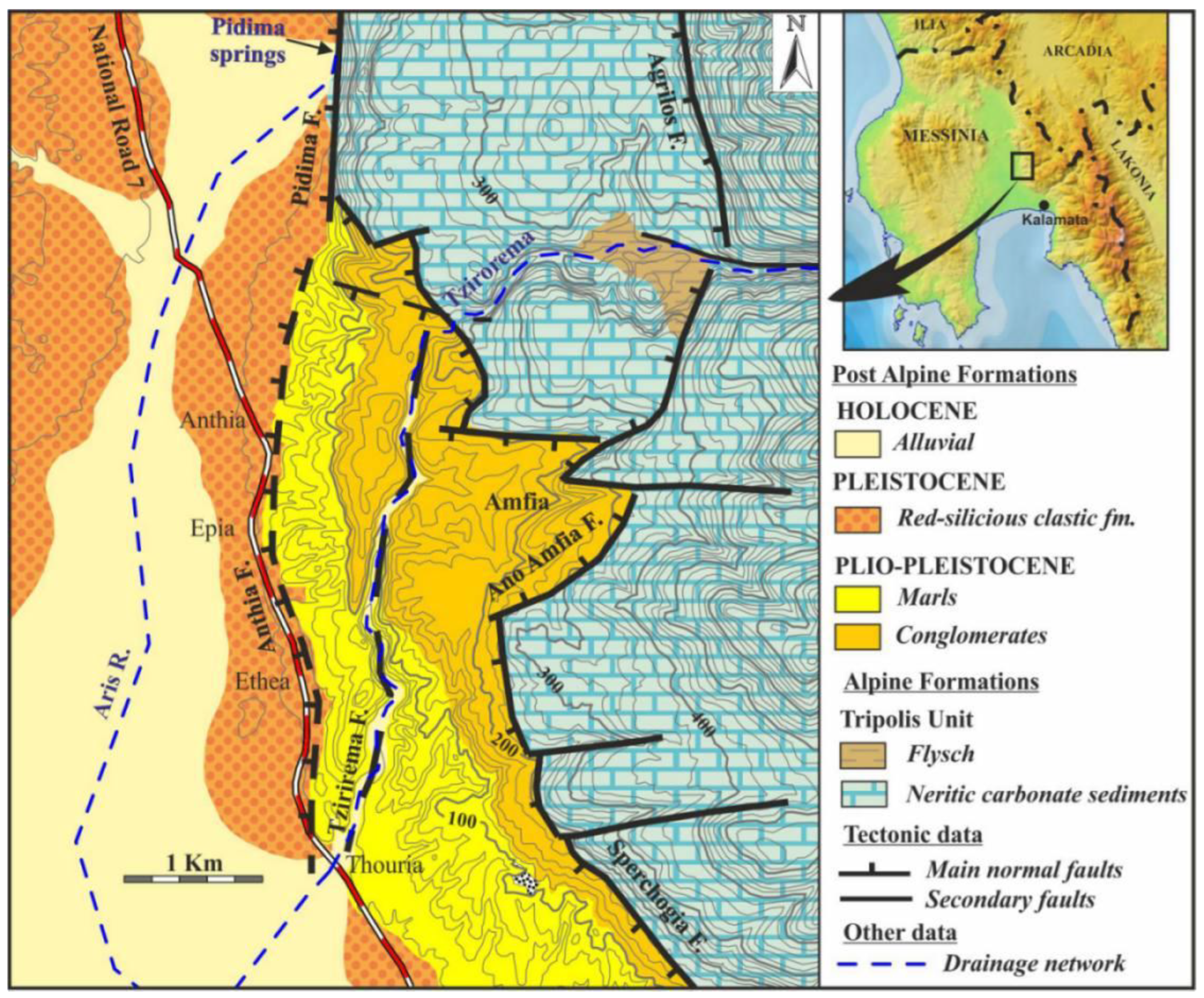
The 30 km–long, N–S-trending Kalamata Basin is bounded to the east by the Taygetos range and to the west by the Kyparissia and Pylia ranges [26,27]. The Eastern Messinia Fault Zone (EMFZ) comprises a complex array of west-dipping normal faults striking NNW–SSE to nearly N–S [18,19,20,26,28,29,30,31,32,33]. Extending for more than 100 km, the system runs from the northern Messinia Plain southward to the Mani Peninsula [34]. Its surface trace follows the western flank of the Taygetos Mountains, east of the Arfara and Pidima villages (Figure 2).
Figure 2.
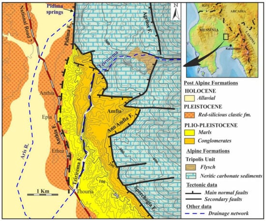
Geological map of the study area. Sampling was conducted along the trace of the fault segment labeled as Pidima Fault (geological map by L. Ladas).
The association of the EMFZ with local human settlement dates back to prehistory and antiquity. In particular, the ruins of the ancient city of Thouria are situated on an elongated north–south-trending ridge approximately 10 km northwest of modern Kalamata, on the western side of the Kalamata–Tripolis motorway [19,20]. The ridge comprises several low hilltops that rise progressively toward the north, reaching a maximum elevation of about 200 m. Archaeological evidence [19,20,35] indicates continuous occupation since the Early Bronze Age (3rd millennium BC). During the Mycenaean period (1600–1050 BC), Thouria developed into a major settlement within the territory [36]. Habitation at Thouria continued well into historical times. Excavations conducted since 2007 have revealed numerous boulders embedded within the debris that buried the ancient city’s architectural remains.
Among the earthquakes recorded in historical sources, the 464 BC event that devastated Sparta remains a key reference for Greek seismology [8]. However, there is no solid evidence that this earthquake affected the Thouria area. Given the short distance between the two valleys (Thouria lies only about 40 km west of Sparta) the 464 BC earthquake is generally interpreted as a shallow crustal event rather than a subduction-related one. Given the extensive collapse deposits, it is more likely that Ancient Thouria was repeatedly affected (and ultimately destroyed) by a series of strong earthquakes occurring primarily between the 1st century BC and the 1st century AD [37,38].
The Kalamata earthquake of 13 September 1986 represents the most significant recent seismic event in the area, causing substantial damage to the city’s infrastructure. The earthquake was generated by a north–south–striking, west-dipping normal fault located near Kalamata [39,40,41,42,43,44], with the epicenter located about 10 km east-southeast of the study area [40].
Subsequently, most of the 2011 earthquake swarm events occurred within the hanging wall of the large NNW–SSE-trending normal fault zone within the EMFZ that bounds the Upper Messinia Basin to the east [26,27,45]. These seismic episodes were likely shallow crustal events, comparable in faulting mechanism to the 1986 normal-faulting earthquake that heavily damaged Kalamata. The Eastern Messinia Fault Zone (EMFZ) is thought to have experienced at least one more strong earthquake during the 19th century, notably in 1846 [39]. Information on the estimated magnitudes, reported damage, and event details is provided in the earthquake catalogs of Ambraseys and Jackson [46], Ambraseys [47], Papazachos and Papazachou [48], and Papadopoulos [49].
In terms of seismic hazard assessment, as well as for understanding the neotectonic evolution of the western flanks of Mount Taygetos, it is crucial for this area to obtain quantitative estimates of fault slip rates. Vital infrastructure extends along the eastern margin of the Messinia Basin, including the motorway linking Kalamata with the rest of the Peloponnese and mainland Greece, as well as aqueducts that convey water from springs at the western foothills of Mount Taygetos to the city. Fuel pipelines also run subparallel to segments of the Eastern Messinia Fault Zone (EMFZ). The commercial and military airport, located nearby, together with the structural integrity and safety of Kalamata itself, make specific segments of the Eastern Messinia Fault Zone (EMFZ) a priority target for detailed investigation.
Paleoseismological trenching, when conducted at strategically selected sites along a fault, is a well-established method for identifying displacement events through the analysis of cross-cutting relationships within faulted stratigraphy [25]. Previous paleoseismological investigations by Zygouri et al. [25] documented five surface-faulting events between 16.7 ka and 1 ka, with a minimum cumulative displacement of 3.52 m across the fault. Nevertheless, although highly effective, colluvial trenching primarily captures major vertical displacement events (earthquakes) and may overlook minor or aseismic vertical offsets. As an alternative fault-dating technique, cosmogenic nuclide analysis can be applied; in the case of carbonate bedrock, the preferred isotope is cosmogenic 36Cl [50,51,52,53,54,55,56]. This study aims to provide preliminary numerical constraints on fault slip, which (although locally derived) may still be valuable for broader extrapolation along the fault zone.
2. Geological Setting
Crustal deformation within the upper plate of the Hellenic subduction system, particularly across the southern Peloponnese, is mainly accommodated by active extensional faulting along a set of NNW–SSE–striking normal faults [26,42,57,58,59]. The neotectonic macrostructure of southwestern Peloponnese is characterized by alternating tectonic basins and horsts bounded by major fault zones trending NNW–SSE and E–W [19,20,60,61]. Fault segments within this system exhibit variable seismic behavior: some are highly active during specific earthquakes, while others remain quiescent, as was observed during the 13 September 1986 Kalamata earthquake [62]. Within onshore Messinia, the majority of this deformation is accommodated by the Eastern Messinia Fault Zone (EMFZ), which corresponds to a major, structurally complex system of west-dipping normal faults that delineate the western flank of the Taygetos Mountain range and extend southward along the Mani Peninsula (Figure 1 and Figure 2) [26,34,43,45].
The EMFZ strikes from NNW–SSE to nearly N–S and attains a cumulative length exceeding 100 km, extending from the northern Messinia Plain to the southern extremity of the Mani [34]. Its structural continuity is frequently interrupted by overlapping fault segments, which form characteristic relay ramps and stepovers, indicative of distributed strain and local fault growth processes along its length. Such structural arrangements suggest a history of progressive fault linkage and propagation through time. Stress analyses of fault striations along the EMFZ indicate a prevailing WSW–ENE extensional stress regime, fully compatible with focal mechanisms of modern seismic events [16,27,40] as well as GPS-derived extensional strain patterns [63,64]. Collectively, these observations confirm that the EMFZ represents one of the most active normal-fault systems in the southern Peloponnese, playing a major role in accommodating present-day crustal extension across the western margin of the Hellenic Arc.
The study area occupies the eastern margin of the Lower Messinia tectonic basin, a structural depression forming the northern continuation of the Messenian Gulf [60,62]. This asymmetric graben displays a marked contrast between its two flanks: the eastern margin, which is tectonically active, steeply faulted, and fronted by a series of small alluvial fans, and the western margin, which remains relatively stable and undeformed. The eastern boundary of the basin is defined by a NNW–SSE–trending fault zone [17,46,65,66,67] consisting of major en échelon normal faults and a network of smaller parallel and transverse structures that fragment the basin into a series of distinct tectonic blocks. The en échelon fault geometry and the presence of minor transverse faults indicate that deformation is oblique-normal, combining both dip-slip and strike-slip motion [62].
The geological formations of the study area are divided into Alpine and post-Alpine units [68]. The Alpine formations correspond to Cretaceous thick-bedded limestones belonging to the carbonate sequence of the Tripolis Unit (Figure 2), which crops out eastward in the mountainous region of Taygetos. The post-Alpine formations consist mainly of marls and strongly cemented Pliocene conglomerates that are intersected by the active fault zone. Along the steep slopes of the ridge, parallel to this marginal fault system, extensive rockfalls of large conglomeratic blocks are observed.
The exposure examined in this study (Figure 3 and Figure 4) lies along the western boundary of this fault zone, which separates the Lower Messinia Basin from the uplifted Taygetos horst (Figure 2). This boundary produces a sharp morphological contrast, with Tripolis Unit limestones in the footwall juxtaposed against post-Alpine conglomerates and younger sedimentary formations in the hanging wall. The fault zone remains active, as supported by recent seismological investigations [17] and by the reactivation of its northern segment during the 2011 Upper Messinia earthquake swarm [26,27,69].
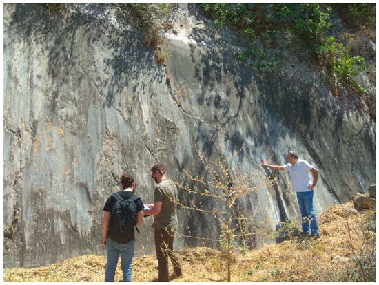
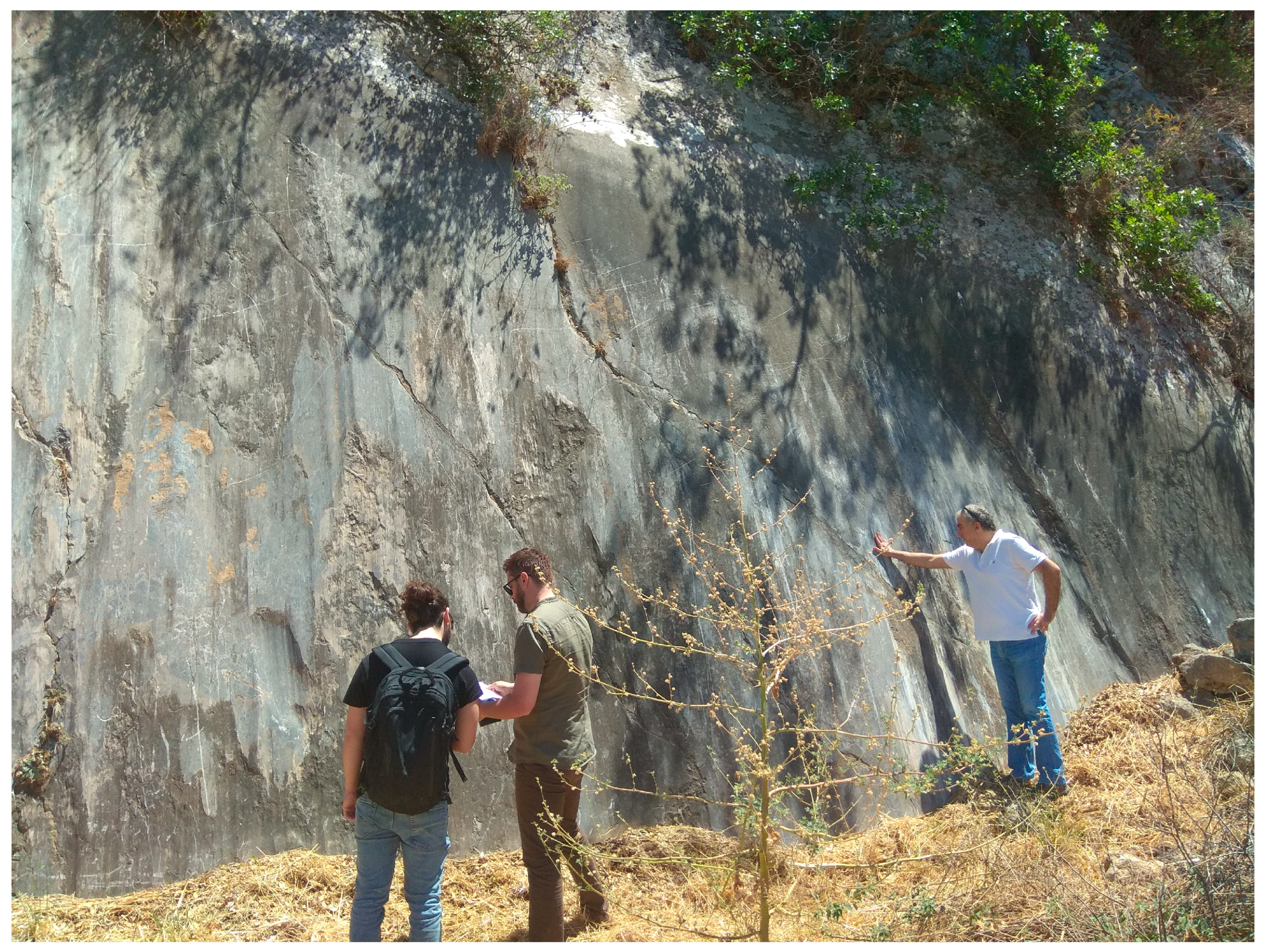
Figure 3.
View of the fault plane at its northernmost extent, just before the escarpment fades out towards the North. The apparent freshness of the fault plane (previously examined by (25) and (33)) is due to a recent colluvial fall related to earthworks on that spot. This sector was not included in the cosmogenic dating and is shown solely to illustrate the surface roughness of the fault plane.
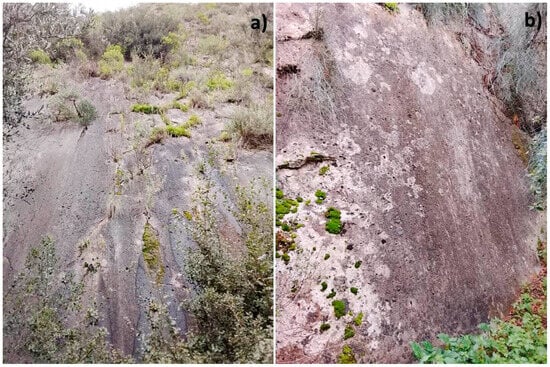
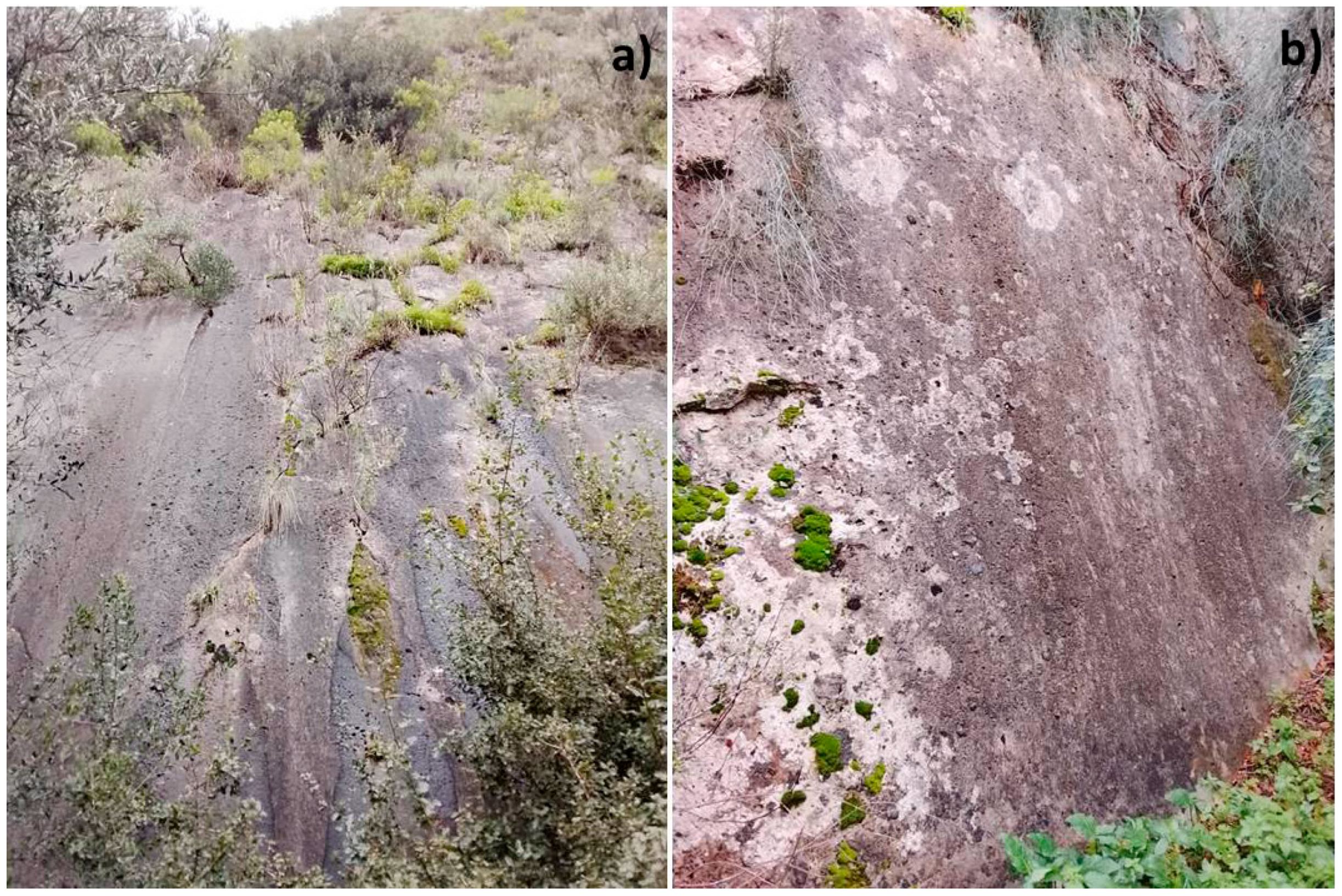
Figure 4.
General view (a) and close-up (b) of the sampled fault plane, highlighting its surface quality and textural characteristics.
At Thouria, this fault zone forms a well-defined scarp, where borehole data indicate that the hanging wall has subsided by more than 200 m, confirming significant vertical displacement [19,20]. The fault geometry and dip characteristics are comparable to those of the Kalamata Fault, which dips approximately 45° westward, extends to depths of around 10 km, and represents an internal segment parallel to the Eastern Messinia Fault Zone (EMFZ). It likely forms part of the same kinematic framework [17,40,41,43,70], indicating that both structures share similar seismogenic behavior and are capable of generating shallow, high-intensity normal-faulting earthquakes. The presence of such subparallel fault strands within the EMFZ highlights the distributed nature of extension across the Lower Messinia Basin and supports interpretations of a multi-segmented, evolving normal-fault system that accommodates ongoing back-arc extension in the southern Peloponnese.
The primary kinematic attributes of a fault plane (Figure 3), namely, the dip angle, dip direction, and slip-vector orientation), have been determined through detailed t-LiDAR imaging and point-cloud analysis [33]. The resulting geometric data reveal that the Pidima scarp is non-planar, with dip directions ranging from N206°E to N280°E and dip angles varying between 57° and 79° [33]. Field measurements yield mean values of approximately N250°E for dip direction and 70.5° for dip angle. The rake measurements indicate a minor dextral (right-lateral) slip component of about 5–10° on the fault surface [33]. Study of the fault-plane roughness and paleoseismological trenching [25,33], respectively, has provided evidence for five surface-rupturing earthquakes of M > 6.4, corresponding to an apparent slip rate of 0.23 mm/yr (or 0.28–0.44 mm/yr) [25].
3. Samples, Methodology and Results
This preliminary investigation provides numerical constraints on the average slip rate along a strike-parallel section of the Pidima segment of the Eastern Messinia Fault Zone (EMFZ), rather than conducting a full paleoseismological analysis involving closely spaced sampling along the slip direction [18,19,20,26,28,29,30,31,32,33]. Estimation of time-averaged slip rates requires relating the numerical age of an exposed fault surface to the cumulative displacement represented by its position along the fault plane. Specifically, the cosmogenic 14Cl age obtained for a given point on the fault plane is apportioned to the vertical (or dip-parallel) separation between that point and a reference level, allowing the calculation of an average slip rate over the time interval recorded by the preserved fault exposure. The time-averaged slip rate remains informative even in the absence of closely spaced cosmogenic ages, as it constrains the long-term behavior of a fault and assesses its tectonic significance. A time-integrated slip rate provides a robust first-order constraint on fault kinematics and contextualizes the fault’s role within the regional deformation field.
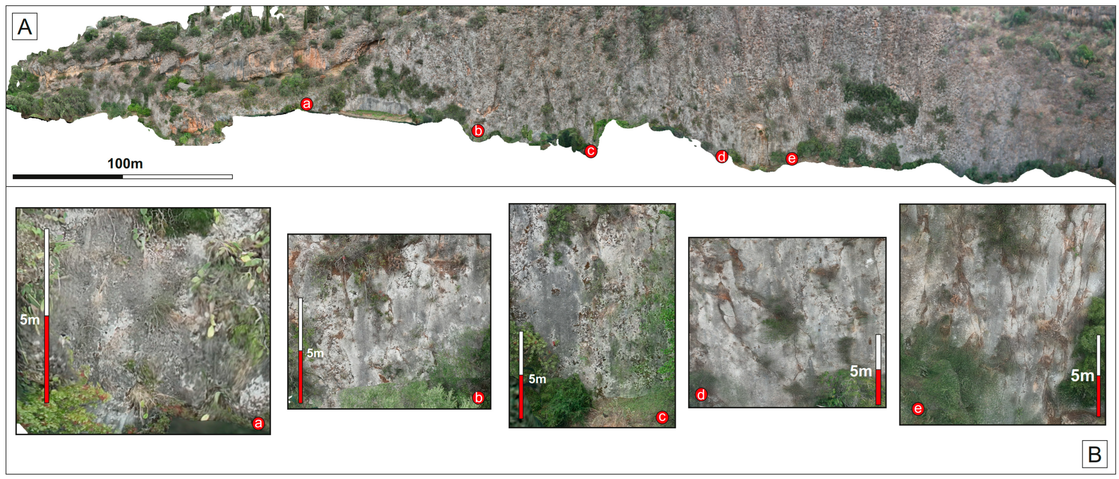
This site was selected because the fault exhibits its greatest morphological prominence here, with the fault plane being relatively well preserved. In addition, the location lies in close proximity to areas previously investigated through LiDAR analysis [33] and trenching studies [25] allowing direct comparison with existing structural and chronological data. Samples were collected away from artificially affected surfaces, at locations unlikely to have been artificially modified by human activity, as suggested by their difficult accessibility. Even at these sampling sites, the fault plane retains a noticeable surface sheen (Figure 4). While clear striations are not preserved at the surface (though faint striations become visible after shallow excavation of a few decimeters using a geological hammer at the fault’s base), grooves remain discernible. This indicates only minimal weathering of the fault surface, on the order of a few millimeters, comparable to the original thickness of the striations. Samples were collected at approximately human height along a ~200 m portion of the fault trace (Figure 5). Particular care was taken to choose sampling sites free from artificial disturbance while preserving the natural freshness of the fault surface (that is, avoiding locations exhibiting increased surface roughness). Areas that had been recently excavated through colluvial deposits (between locations a and b in Figure 5) were explicitly excluded, as they had already been the focus of previous investigations [33].
Figure 5.
(A) Drone-acquired imagery of the studied fault segment in the Pidima area (imagery captured by I. Vakalas). (a–e) The sample spots. (B) The fault surface around the sample spot.
The accumulation of terrestrial cosmogenic nuclides on eroding rock surfaces can be expressed using a generalized equation adapted from Lal [71]. In this framework, denotes the concentration of a specific cosmogenic nuclide (here 36Cl) at time (years), while refers to the particular production pathway (e.g., spallation, thermal and epithermal neutron capture, fast muons, or slow muon capture).
In surface rocks, 36Cl is mainly produced by spallation reactions between high-energy neutrons (10–103 MeV) and target elements such as Ca, K, Ti, and Fe, and by the capture of low-energy (thermal to epithermal) neutrons (0.025–100 MeV) by 35Cl. Additional production arises from the capture of slow negative muons by Ca and K, though this contribution is minor compared to that from neutron-induced reactions near the Earth’s surface. Furthermore, high-energy (relativistic) muons can emit bremsstrahlung gamma rays as they decelerate in matter, causing nuclear disintegration and neutron release; once thermalized, these neutrons may be captured to form 36Cl [71,72].
is the surface production rate via pathway (atoms·g−1·a−1), is rock density (g·cm−3) and is the decay constant () for radioactive nuclides, specifically (2.303 ± 0.016)·10−6, corresponding to a 36Cl half-life of 3.014·105 years. denotes the characteristic attenuation length (g·cm−2) for each production process, i.e., the depth at which the cosmic-ray flux decreases by a factor of . The erosion rate, (mm·a−1), influences the long-term surface concentration. represents any inherited nuclide concentration from prior exposure events [73,74,75,76,77,78,79,80,81,82,83]. As in most 36Cl-based studies aimed at constraining fault-scarp slip rates [54,84,85,86,87,88], this work assumes a long, planar scarp progressively exhumed through successive faulting events, typically requiring multiple samples for reliable dating. In this study, an exposure model was employed that considers only present-day topographic shielding and the latitudinal scaling of cosmic-ray flux. Under these assumptions, the inherited nuclide concentration was set to zero, and erosion rate was considered negligible. Treating the system as far from steady state, solving Equation (1) for t therefore yields the exposure ages.
Terrestrial LiDAR (t-LiDAR) analysis of a recently exhumed (Figure 3) surface [33], north of the segment studied/sampled here, revealed that the fault plane roughness clearly increases upscarp. Corrugations and minor bends contribute to greater irregularity toward the top of the scarp, while no significant longitudinal variation was detected, as the roughness pattern remains fairly consistent along strike. Roughness maps from Karamitros et al. [33] express absolute metric deviations from a best-fit plane, showing that, within a 2 m vertical interval, roughness increases by approximately one standard deviation, corresponding to about 1–2 cm of microtopographic relief. This uncertainty has been accounted for in the shielding calculations.
Carbonate samples were chemically processed following standard procedures [40,78,79,83]. 36Cl and 35Cl concentrations were measured via isotope dilution Accelerator Mass Spectrometry (AMS) at the ASTER national facility (CEREGE, Aix-en-Provence) [89] and normalized against the 36Cl standard SM-CL12 (prepared by S. Merchel) with a 36Cl/35Cl ratio of (1.428 ± 0.02)×10−12 [90]. Analytical uncertainties include counting statistics, instrument stability, and blank corrections (blank ratio 2.2408×10⁻¹⁵ ± 23%, which account for 0.3–2.38% of measured concentrations (Table 1). Calcium concentration was determined by ICP-OES (ICAP 6500, Thermo Fisher Scientific, Waltham, MA, USA).
Table 1.
Sample positions, sample height above ground surface, shielding factor, 36Cl and natural Cl concentrations, exposure age and average slip rates. Exposure age is given without denudation.
Age calculations followed the approach of Schimmelpfennig et al. [91], employing updated sea-level, high-latitude spallation production rates: 42.2 ± 4.8 atoms·g−1·a−1 for Ca [92]; 148.1 ± 7.8 for K [93]; 13 ± 3 for Ti [94]; and 1.9 ± 0.2 for Fe [95]. The production rate of epithermal neutrons from fast neutrons at the land–atmosphere interface was taken as 696 ± 185 atoms·g−1 from Marrero et al. [96]. All production rates were scaled using Stone’s polynomial [97] and corrected for topographic shielding measured in the field with a compass and clinometer.
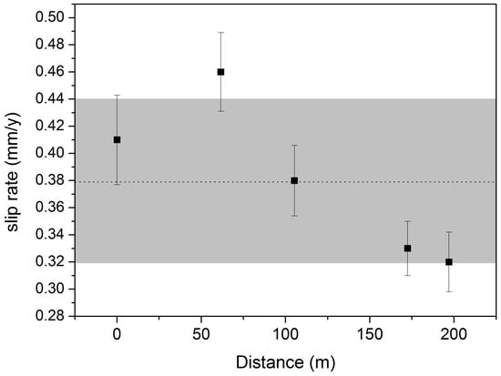
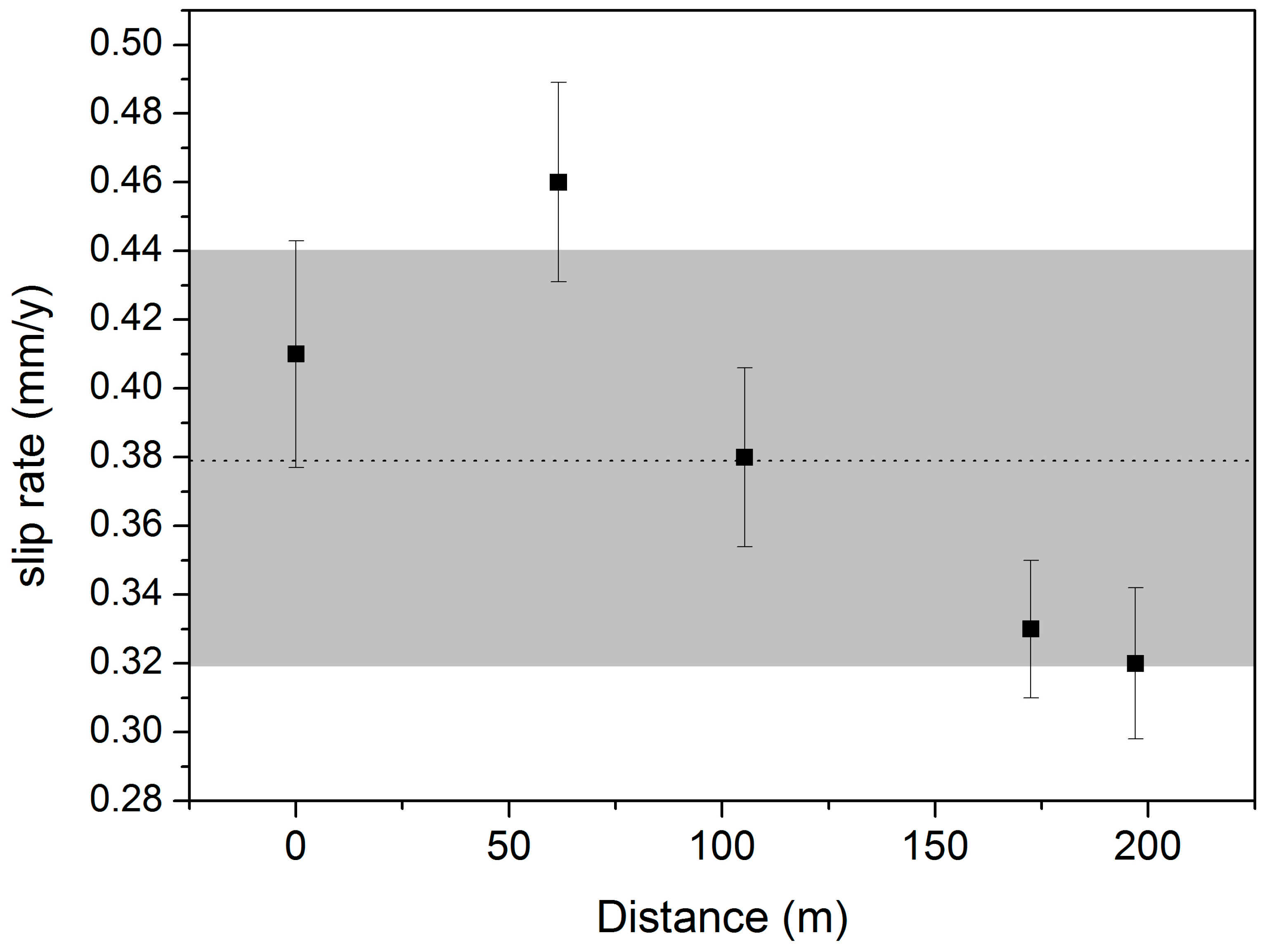
Table 1 presents the AMS-measured 36Cl concentrations, the corresponding cosmogenic 36Cl exposure ages, and the inferred time-averaged slip rates. The calculated slip rates range between 0.32 and 0.46 mm/yr, showing a gradual increase toward the northern end of the sampled fault trace. Figure 6 illustrates the along-strike distribution of slip rates calculated from cosmogenic 14C ages, with an average slip rate of 0.38 mm/yr. A gradual decrease in slip rate is observed toward the southern end of the sampled segment.
Figure 6.
North (left)–south (right) distribution of slip rates along the sampled segment of the EMFZ. The horizontal dashed line denotes the average slip rate, while the gray shaded band represents one standard deviation about the mean.
4. Discussion
The exposure ages presented in Table 1 fall within the latter half of the Holocene, providing clear evidence for the recent activity of the fault. We are cautious about directly associating these ages with individual earthquake events, although such a correspondence is possible since each measured age could represent a distinct exhumation episode. Nevertheless, in this study we refrain from interpreting these ages as specific seismic events and instead treat them as benchmark indicators for estimating average ground-to-sample slip accumulated over the corresponding 36Cl exposure period. Be that as it may, our estimates (~0.38 mm/y on average) are in good agreement with those of Zygouri et al. [25] and Karamitros et al. [33], albeit toward the higher end of the reported range. Considering the revised average uplift rates, the height of the preserved facet suggests an inferred formation age for the footwall escarpment somewhat later than ~330 ka. Nevertheless, a slip-rate range of 0.32–0.46 mm/yr over ~200 m of a fault trace (Figure 6) does not, by itself, imply the presence of considerable asperities. Such variability is expected and may reflect dating uncertainties, geomorphic smoothing, or minor local geometric irregularities, rather than persistent, mechanically strong asperities that accumulate shear stress and release it seismically. Slip accumulation can, thus, be considered spatially coherent in the study area.
The destructive earthquake of 13 September 1986 (Mw = 5.8) represents the largest event recorded during the instrumental seismological period associated with the EMFZ. For this reason, it has served as a reference event for both paleoseismological and contemporary seismological studies in the region [26,27,45]. The earthquake caused numerous casualties and severe damage to a large portion of the urban fabric. Damage was widespread throughout the town and extended to several nearby villages, resulting in dozens of fatalities [46,47,48,49]. Using the empirical scaling relationships of [98], a Mw = 5.8 crustal earthquake is expected to produce ~0.1 m of average surface slip (and up to ~0.3 m of maximum coseismic displacement). Knowledge of the occurrence and effects of such events contributes to linking seismological observations with paleoseismological and archaeological records and to evaluating their relevance for modern infrastructure.
Assuming that slip on the fault occurs primarily during earthquakes, then the long-term geologic slip rate (e.g., [99]) represents the time-averaged rate at which elastic strain accumulates and is released coseismically. If slip occurs predominantly during earthquakes, then over a sufficiently long time interval the average slip rate () can be expressed as:
where is the coseismic slip of the i-th event and is the inter-event time. Assuming approximately characteristic coseismic slip per event such that then and , then , then the above expression reduces to [99,100]:
Here, T denotes a kinematic loading timescale. For example, extrapolating a mean slip rate of ~0.38 mm yr−1 along the EMFZ, an Mw 5.8 earthquake associated with ~0.1 m of average coseismic slip would require approximately = 100/0.38 = 263 years to re-accumulate the corresponding slip deficit. This estimate reflects the kinematic loading time for an event of this size, assuming fixed fault geometry, and should not be interpreted as earthquake periodicity. Although ~263 years may be required to re-accumulate ~0.1 m of slip deficit, nothing requires the fault to fail precisely at that time, nor to repeat the same timing in subsequent cycles. Treating this loading timescale as a true recurrence interval would require the fault to behave as a deterministic oscillator (characterized by constant loading, complete interseismic locking, and identical stress drop from event to event), conditions that are inconsistent with the physics of frictional fault failure. Within this framework, higher slip rates imply shorter times to accumulate a given amount of slip deficit, whereas lower slip rates imply longer accumulation times.
The fact that the 1986 Mw = 5.8 earthquake occurred approximately 140 years after the previous large event in the EMFZ 1846 [39], significantly earlier than the ~260 years required to rebuild the nominal coseismic slip, highlights the non-periodic nature of rupture on the EMFZ and indicates that failure can occur before full slip-deficit re-accumulation. In this sense, ~263 years represents the characteristic loading time required for the EMFZ to re-establish the slip deficit associated with an Mw 5.8 event, rather than a deterministic recurrence interval. Whether rupture occurs earlier or later depends on evolving stress conditions, rupture geometry, and fault interactions, rather than on slip accumulation alone.
Such rates (whether expressed as slip or extension) are almost an order of magnitude lower than those observed in rapidly extending structures elsewhere in the Aegean, such as the Corinth Rift or the Central Aegean domain [101,102,103,104] where rates an order of magnitude higher are typical of active rifting and strain localization along a few major fault systems driven by back-arc extension associated with Hellenic slab rollback [105]. In contrast, the lower slip and extension rates in Messinia suggest a greater partitioning of strain across multiple smaller or secondary faults, each accommodating deformation at modest rates. Consequently, the southern Peloponnese crust appears to deform more diffusely than, e.g., the Corinth Rift or the Central Aegean, distributing extensional strain across a broad zone rather than concentrating it within a single, highly active structure.
Our results, together with those reported by the aforementioned authors, depart from the somewhat higher slip rates proposed by Papoulia et al. [106], who assessed the seismic hazard of the offshore basin-margin normal fault zone and estimated a minimum long-term slip rate of 1.1 mm/yr, as well as the Sparta Fault which as has been assigned a comparable slip rate of about 1 mm/yr [8,56]. Those values were more consistent with rifting-intense deformation processes than with the slower, more diffuse extension observed in the Messinia region. Moreover, the average numerical slip rate serves as a proxy for the long-term rate of tectonic strain accumulation along a fault. It reflects how rapidly elastic deformation builds up in the surrounding rocks and, consequently, how often the system can produce large earthquakes. A fault that accumulates strain more quickly reaches its critical stress threshold more frequently, leading to shorter recurrence intervals between seismic events. In general, higher slip rates correspond to faster strain accumulation, and therefore, faster-slipping faults tend to rupture more frequently and are capable of generating larger earthquakes, provided that fault length is sufficient.
Thus, slip rate correlates indirectly with the seismic potential of a fault [107,108,109], as it reflects both the tectonic loading rate and the capacity of the fault to accumulate strain energy between ruptures. Empirical scaling relationships [98,110] link fault length, displacement, and slip rate to seismic moment release, and hence to potential earthquake magnitude. Faults with slip rates below ~0.5 mm/yr are typically limited to events of M ≤ 6.5 [98], which is on the order of the magnitudes estimated by Zygouri et al. [25] or observed during historical seismic activity within the Eastern Messinia Fault Zone, such as the 1986 Kalamata earthquake with Ms = 6.2 [41] or Mw = 5.8 [40]. It is also plausible to suggest that the Thouria Fault Zone is capable of producing earthquakes of comparable magnitude. It should be noted, however, that part of the total slip may be aseismic, occurring through creep or distributed deformation. While slip rates integrate strain accumulation over 103–105-year timescales, earthquake recurrence operates over 102–103-year intervals. The discrepancy between our time-averaged slip rates and the estimates of Zygouri et al. [25] may, in fact, reflect the contribution of such aseismic slip to the total deformation budget.
5. Conclusions
This study highlights the critical role of long-term fault slip rates in assessing seismic hazard where active tectonics intersect modern infrastructure. Through cosmogenic 36Cl exposure dating, we provide independent numerical constraints on recent fault activity along the Eastern Messinia Fault Zone (EMFZ). The derived average slip rates of ~0.32–0.46 mm/yr confirm that the EMFZ is an active structure during the late Holocene, consistent with previous trenching and geomorphic studies, yet indicative of relatively slow, diffuse extension compared to rapidly extending regions of the Aegean. These rates imply characteristic loading times on the order of a few centuries for moderate (Mw ~5.8–6.0) earthquakes. Although individual exposure ages cannot be unambiguously tied to single earthquakes, they provide robust benchmarks for cumulative slip and long-term strain accumulation. In regions such as Messinia, where critical infrastructure parallels active faults, such constraints are essential for realistic seismic hazard assessment. More broadly, this study illustrates how numerical dating techniques (particularly cosmogenic nuclide methods applied to carbonate bedrock) can bridge the gap between geological timescales and engineering needs. By constraining fault behavior over 103–105-year intervals, such approaches complement instrumental and historical records and provide a physically grounded basis for evaluating long-term seismic potential in complex, actively deforming tectonic settings.
Author Contributions
Conceptualization, C.D.A. and V.K.; methodology, C.D.A. and R.B.; software, I.V.; validation, C.D.A. and R.B.; formal analysis, C.D.A. and R.B.; investigation, C.D.A., V.K., I.V., I.L., K.T. and H.Z.; resources, C.D.A.; data curation, C.D.A., R.B., V.K. and I.V.; writing—original draft preparation, C.D.A. and V.K.; writing—review and editing, C.D.A. and V.K.; visualization, I.V. and I.L.; supervision, C.D.A.; project administration, C.D.A.; funding acquisition, C.D.A. All authors have read and agreed to the published version of the manuscript.
Funding
This project was funded by the regular budget of the National Technical University of Athens (NTUA).
Data Availability Statement
The original contributions presented in this study are included in the article. Further inquiries can be directed to the corresponding author.
Acknowledgments
ASTER AMS, national facility (CEREGE, Aix en Provence), is supported by the INSU/CNRS and IRD and member of AIX MARSEILLE PLATFORMS and REGEF networks.
Conflicts of Interest
The authors declare no conflicts of interest.
References
- Benedetti, C.L.; Woerd, J. Cosmogenic nuclide dating of earthquakes, faults and toppled blocks. Elements 2014, 10, 357–361. [Google Scholar] [CrossRef] [Scilit]
- Valentini, A.; Fukushima, Y.; Contri, P.; Ono, M.; Sakai, T.; Thompson, S.; Viallet, E.; Annaka, T.; Chen, R.; Moss, R.E.S.; et al. Probabilistic fault displacement hazard assessment (PFDHA) for nuclear installations according to IAEA safety standards. Bull. Seismol. Soc. Am. 2021, 111, 2661–2672. [Google Scholar] [CrossRef] [Scilit]
- Gosse, J.C. LA-UR 96-1773 (Los Alamos National Laboratory Report). U.S. Department of Energy, 1995. Available online: https://www.osti.gov/servlets/purl/245626 (accessed on 5 September 2025).
- Keefer, W.R.; Whitney, J.W.; Taylor, E.M. (Eds.) Quaternary Paleoseismology and Stratigraphy of the Yucca Mountain Area, Nevada; U.S. Geological Survey Professional Paper 1689; U.S. Department of the Interior, U.S. Geological Survey: Reston, VA, USA, 2004.
- Fattahi, M. OSL dating of the Miam Qanat (KĀRIZ) system in NE Iran. J. Archaeol. Sci. 2015, 59, 54–63. [Google Scholar] [CrossRef] [Scilit]
- Bailiff, K.I.; Jankowski, N.; Snape, M.L.; Gerrard, M.C.; Gutiérrez, A.; Wilkinson, N.K. Luminescence dating of qanat technology: Prospects for further development. Water Hist. 2018, 10, 73–84. [Google Scholar] [CrossRef] [Scilit]
- Begg, J.; Mouslopoulou, V.; Heron, D.; Nicol, A. AFG—Active faults Greece: A comprehensive geomorphology–based 1:25,000 fault database. Sci. Data 2025, 12, 1853. [Google Scholar] [CrossRef] [Scilit] [PubMed]
- Armijo, R.; Lyon–Cean, H.; Papanastasiou, D. A possible normal-fault rupture for the 464 BC Sparta earthquake. Nature 1991, 351, 137–139. [Google Scholar] [CrossRef] [Scilit]
- Pavlides, S. Palaeoseismology: A branch of Neotectonics linking Geological, Seismological and Archaeological data-an Introduction. In Archaeoseismology; Stiros, S., Jones, R., Eds.; Institute of Geology and Mineral Exploration and The British Scholl at Athens: Athens, Greece, 1996; pp. 15–19. [Google Scholar]
- Stiros, S. Identification of earthquakes from archaeological data: Methodology, criteria and limitations. In Archaeoseismology; Fitch Laboratory Occasional Paper 7; Stiros, S., Jones, R., Eds.; Institute of Geology and Mineral Exploration and The British Scholl at Athens: Athens, Greece, 1996; pp. 129–152. [Google Scholar]
- Papadopoulos, G.A. An Earthquake Engineering Approach in the Collapse of the Mycenean Palace Civilization of the Greek Mainland. In Archaeoseismology; Fitch Laboratory Occasional Paper 7; Stiros, S., Jones, R., Eds.; Institute of Geology and Mineral Exploration and The British Scholl at Athens: Athens, Greece, 1996; pp. 205–214. [Google Scholar]
- Triantafyllou, I.; Papadopoulos, A.G.; Lekkas, E. Impact on built and natural environment of the strong earthquakes of April 23, 1933, and July 20, 2017, in the Southeast Aegean Sea, Eastern Mediterranean. Nat. Hazards 2019, 100, 671–695. [Google Scholar] [CrossRef] [Scilit]
- Caputo, M.; Panza, F.G.; Postpischl, D. Deep structure of the Mediterranean Basin. J. Geophys. Res. 1970, 75, 4919–4923. [Google Scholar] [CrossRef] [Scilit]
- Papazachos, C.B.; Comninakis, E.P. Geophysical and tectonic features of the Aegean Arc. Tectonophysics 1971, 46, 285–296. [Google Scholar] [CrossRef] [Scilit]
- Hatzfeld, D.; Pedotti, G.; Hatzidimitriou, P.; Panagiotopoulos, D.; Scordilis, M.; Drakopoulos, I.; Makropoulos, K.; Delibasis, N.; Latousakis, I.; Baskoutas, J.; et al. The Hellenic subduction beneath the Peloponnese, first results of a microearthquakes study. Earth Planet. Sci. Lett. 1989, 93, 283–291. [Google Scholar] [CrossRef] [Scilit]
- Hatzfeld, D.; Pedotti, G.; Hatzidimitriou, P.; Makropoulos, K. The strain pattern in the western Hellenic arc deduced from a microeathquake survey. Geophys. J. Int. 1990, 101, 181–202. [Google Scholar]
- Papoulia, J.; Makris, J. Microseismicity and active deformation of Messinia, SW Greece. J. Seismol. 2004, 8, 439–451. [Google Scholar] [CrossRef] [Scilit]
- Kokkalas, S.; Xypolias, P.; Koukouvelas, I.K.; Doutsos, T. Post-collisional contractional and extensional deformation in the aegean region. In Post-Collisional Tectonics and Magmatism in the Mediterranean Region and Asia; Dilek, Y., Pavlides, S., Eds.; Geological Society of America: Boulder, CO, USA, 2006; pp. 97–123. [Google Scholar]
- Ladas, I.; Mariolakos, I.; Fountoulis, I. The neotectonic deformation of Pylia (SW Peloponnese, Greece). Bull. Geol. Soc. Greece 2004, 36, 1652–1661. [Google Scholar] [CrossRef] [Scilit]
- Ladas, Y.; Trikolas, K.; Mariolakos, I.; Arapogianni, X.; Sabaziotis, S. Geological–Neotectonic conditions and destructive phenomena at the archeological site of Ancient Thouria (SW Peloponnese, Greece). In Proceedings of the 10th International Congress of the Hellenic Geographical Society, Thessaloniki, Greece, 22–24 October 2014. [Google Scholar]
- Papanikolaou, D.; Fountoulis, I.; Metaxas, C. Active faults, deformation rates and Quaternary paleogeography at Kyparissiakos Gulf (SW Greece) deduced from onshore and offshore data. Quat. Int. 2007, 171–172, 14–30. [Google Scholar] [CrossRef] [Scilit]
- Ganas, A.; Parsons, T. 3-D model of Hellenic Arc deformation and origin of the Cretan uplift. J. Geophys. Res. 2009, 114. [Google Scholar] [CrossRef] [Scilit]
- Papazachos, B.; Kiratzi, A.; Papadimitriou, E. Regional focal mechanisms for earthquakes in the Aegean Area. Pure Appl. Geophys. 1991, 136, 407–420. [Google Scholar] [CrossRef] [Scilit]
- Varotsou, E.; Nomikou, P.; Papanikolaou, D.; Poulos, S.; Asteriou, I.; Tsernotopoulos, N.; Tsaparas, Y.; Koliopanos, I.; Petroulia, M. Morphotectonic analysis and associated geohazards: Case study of the Messiniakos Gulf, SW Peloponnese, Greece. Geo-Mar. Lett. 2025, 45, 34. [Google Scholar]
- Zygouri, V.; Koukouvelas, I.; Ganas, A.; Tsimi, C. Clustering of earthquakes along the Pidima-Anthia normal fault: New data from palaeoseismology and tectonic geomorphology and their significance on the earthquake’s regularity and recurrence across southern Greece. J. Struct. Geol. 2023, 176, 104974. [Google Scholar] [CrossRef] [Scilit]
- Ganas, A.; Lekkas, E.; Kolligri, M.; Moshou, A.; Makropoulos, K. The 2011 Oichalia (SW Peloponnese, Greece) seismic swarm: Geological and Seismological evidence for E-W extension and reactivation of the NNW-SSE striking Siamo Fault. Bull. Geol. Soc. Greece 2012, 46, 81–94. [Google Scholar] [CrossRef] [Scilit]
- Kassaras, I.; Kapetanidis, V.; Karakonstantis, A.; Koukouna, V.; Ganas, A.; Chouliaras, G.; Drakatos, G.; Moshou, A.; Mitropoulou, V.; Argyrakis, P.; et al. Constraints on the dynamics and spatio-temporal evolution of the 2011 Oichalia seismic swarm (SW Peloponnesus, Greece). Tectonophysics 2014, 614, 100–127. [Google Scholar] [CrossRef] [Scilit]
- Jacobshagen, V. Structure and geotectonic evolution of the Hellenides. In Proceedings of the VI Colloquium on the Geology of the Aegean Region, Athens 1977; Institute of Geology and Mineral Exploration: Athens, Greece, 1979; Volume 3, pp. 1355–1367. [Google Scholar]
- LePichon, X.; Angelier, J. The Hellenic arc and trench system: A key to the neotectonic evolution of the Eastern Mediterranean area. Tectonophysics 1979, 60, 1–42. [Google Scholar] [CrossRef] [Scilit]
- Mariolakos, I.; Fountoulis, I.; Marcopoulou-Diacantoni, A.; Mirkou, M.R. Some remarks on the kinematic evolution of Messinia province (SW Peloponnese, Greece) during the Pleistocene based on neotectonic, stratigraphic, and paleoecological observations. Münster Forsch. Geol. Palaontol 1994, 76, 371–379. [Google Scholar]
- Koukouvelas, I.K.; Mpresiakas, A.; Sokos, E.; Doutsos, T. The tectonic setting and earthquake ground hazards of the 1993 Pyrgos earthquake, Peloponnese, Greece. J. Geol. Soc. Lond. 1996, 152, 39–49. [Google Scholar] [CrossRef] [Scilit]
- Pavlopoulos, A.; Kamperis, E.; Sotiropoulos, S.; Triantaphyllou, M. Tectonosedimentary significance of the Messinia conglomerates (SW peloponnese, Greece). Bull. Geol. Soc. Greece 2010, 43, 715–725. [Google Scholar] [CrossRef] [Scilit]
- Karamitros, I.; Ganas, A.; Chatzipetros, A.; Valkaniotis, S. Non-planarity, scale-dependent roughness and kinematic properties of the Pidima active normal fault scarp (Messinia, Greece) using high-resolution terrestrial LiDAR data. J. Struct. Geol. 2020, 136, 104065. [Google Scholar] [CrossRef] [Scilit]
- Valkaniotis, S.; Betzelou, K.; Zygouri, V.; Koukouvelas, I.; Ganas, A. Late quaternary tectonic activity and paleoseismicity of the eastern Messinia Fault Zone, SW peloponessus (Messinia, Greece). Geophys. Res. Abstr. 2015, 17, EGU2015-13215-1. [Google Scholar]
- Panagiotidis, V.; Malaperdas, G.; Valantou, V.; Zacharias, N. Environmental aspects of ancient city planning: A pilot study on Ancient Thouria in the Peloponnese, Greece. STAR Sci. Technol. Archaeol. Res. 2019, 5, 257–268. [Google Scholar] [CrossRef] [Scilit]
- Arapogianni, X. Excavations in Ancient Thouria; Ekfrasi Publications: Attica, Greece, 2012. (In Greek) [Google Scholar]
- Arapogianni, X. Ancient Thouria: The Asklepieion; Archeio Publications: Athens, Greece, 2017; pp. 13–14. (In Greek) [Google Scholar]
- Arapogianni, X. Ancient Thouria: The Asclepeion; Archeio Publications: Athens, Greece, 2017; pp. 36–37. (In Greek) [Google Scholar]
- Anagnostopolous, S.A.; Rinaldis, D.; Lekidis, V.A.; Margaris, V.N.; Theodoulidis, N.P. The Kalamata, Greece, earthquake of September 13, 1986. Earthq. Spectra 1987, 3, 365–402. [Google Scholar] [CrossRef] [Scilit]
- Lyon-Caen, H.; Armijo, R.; Drakopoulos, J.; Baskoutas, J.; Delibassis, N.; Gaulon, R.; Kouskouna, V.; Latoussakis, J.; Makropoulos, K.; Papadimitriou, P.; et al. The 1986 Kalamata (South Peloponnese) earthquake: Detailed study of a normal fault, evidences for east-west extension in the Hellenic arc. J. Geophys. Res. 1988, 93, 14967–15000. [Google Scholar] [CrossRef] [Scilit]
- Papazachos, V.; Kiratzi, A.; Karacostas, B.; Panagiotopoulos, D.; Scordilis, E.; Mountrakis, D. Surface fault traces, fault plane solution and spatial distribution of the aftershocks of the September 13, 1986 earthquake of Kalamata (Southern Greece). Pure Appl. Geophys. 1988, 126, 55–68. [Google Scholar] [CrossRef] [Scilit]
- Papanikolaou, D.; Lykousis, V.; Chronis, G.; Pavlakis, P. A comparative study of neotectonic basins across the Hellenic Arc: The Messiniakos, Argolikos, Saronikos and southern Evoikos Gulfs. Basin Res. 1988, 1, 167–176. [Google Scholar] [CrossRef] [Scilit]
- Kazantzidou-Firtinidou, D.; Kassaras, I.; Ganas, A.; Tsimi, C.; Sakellariou, N.; Mourloukos, S.; Stoumpos, P.; Michalaki, K.; Giannaraki, G. Seismic damage scenarios in Kalamata (S. Greece). Bull. Geol. Soc. Greece 2016, 50, 1495–1504. [Google Scholar] [CrossRef] [Scilit]
- Kassaras, I.; Kazantzidou-Firtinidou, D.; Ganas, A.; Kapetanidis, V.; Tsimi, C.; Valkaniotis, S.; Sakellariou, N.; Mourloukos, S. Seismic risk and loss assessment for Kalamata (SW Peloponnese, Greece) from neighbouring shallow sources. Boll. Geofis. Teor. Appl. 2018, 59, 1–26. [Google Scholar]
- Kyriakopoulos, C.; Chini, M.; Bignami, C.; Stramondo, S.; Ganas, A.; Kolligri, M.; Moshou, A. Monthly migration of a tectonic seismic swarm detected by DInSAR: Southwest Peloponnese, Greece. Geophys. J. Int. 2013, 194, 1302–1309. [Google Scholar] [CrossRef] [Scilit]
- Ambraseys, N.N.; Jackson, J.A. Seismicity and associated strain of central Greece between 1890 and 1988. Geophys. J. Int. 1990, 101, 663–708. [Google Scholar] [CrossRef] [Scilit]
- Ambraseys, N. Earthquakes in the Mediterranean and Middle East: A Multidisciplinary Study of Seismicity Up to 1900; Cambridge University Press: Cambridge, UK, 2009; p. 947. [Google Scholar]
- Papazachos, B.C.; Papazachou, C. The Earthquakes of Greece; Ziti: Thessaloniki, Greece, 2003; p. 286. [Google Scholar]
- Papadopoulos, G. A Seismic History of Crete; Ocelotos: Athens, Greece, 2011; p. 385. [Google Scholar]
- Mechernich, S.; Schneiderwind, S.; Mason, J.; Papanikolaou, I.D.; Deligiannakis, G.; Pallikarakis, A.; Binnie, A.S.; Dunai, T.J.; Reicherter, K. The Seismic History of the Pisia Fault (Eastern Corinth Rift, Greece) from Fault Plane Weathering Features and Cosmogenic 36Cl Dating. J. Geophys. Res. Solid Earth 2018, 123, 4266–4284. [Google Scholar] [CrossRef] [Scilit]
- Mechernich, S.; Reicherter, K.; Deligiannakis, G.; Papanikolaou, I. Tectonic geomorphology of active faults in Eastern Crete (Greece) with slip rates and earthquake history from cosmogenic 36Cl dating of the Lastros and Orno faults. Quat. Int. 2023, 30, 77–91. [Google Scholar] [CrossRef] [Scilit]
- Lezzi, F.; Roberts, G.; Faure Walker, J.; Papanikolaou, I.; Ganas, A.; Deligiannakis, G.; Beck, J.; Wolfers, S.; Gheorghiu, D. Temporal and spatial earthquake clustering revealed through comparison of millennial strain-rates from 36Cl cosmogenic exposure dating and decadal GPS strain-rate. Sci. Rep. 2021, 11, 23320. [Google Scholar] [CrossRef] [Scilit]
- Zreda, M.G.; Noller, F.M. Ages of prehistoric earthquakes revealed by cosmogenic chlorine-36 in a bedrock fault scarp at Hebgen Lake. Science 1998, 282, 1097–1099. [Google Scholar] [CrossRef] [Scilit]
- Schlagenhauf, A.; Gaudemer, Y.; Benedetti, L.; Manighetti, I.; Palumbo, L.; Schimmelpfennig, I.; Finkel, R.; Pou, K. Using in situ chlorine-36 cosmonuclide to recover past earthquake histories on limestone normal fault scarps: A reappraisal of methodology and interpretations. Geophys. J. Int. 2010, 182, 36–72. [Google Scholar] [CrossRef] [Scilit]
- Benedetti, L.; Finkel, R.; King, G.; Armijo, R.; Papanastasiou, D.; Ryerson, F.J.; Flerit, F.; Farber, D.; Stavrakakis, G. Motion on the Kaparelli fault (Greece) prior to the 1981 earthquake sequence determined from 36Cl cosmogenic dating. Terra Nova 2001, 15, 118–124. [Google Scholar] [CrossRef] [Scilit]
- Benedetti, L.; Finkel, R.; Papanastasiou, D.; King, G.; Armijo, R.; Ryerson, F.J.; Farber, D.; Flerit, F. Post-glacial slip history of the Sparta fault (Greece) determined by 36Cl cosmogenic dating: Evidence for non-periodic earthquakes. Geophys. Res. Lett. 2002, 29, 1246. [Google Scholar] [CrossRef] [Scilit]
- Armijo, R.; Lyon-Caen, H.; Papanastassiou, D. East-west extension and Holocene normal fault scarps in the Hellenic arc. Geology 1992, 20, 491–494. [Google Scholar] [CrossRef] [Scilit]
- Roberts, G.P.; Ganas, A. Fault-slip directions in central and southern Greece measured from striated and corrugated fault planes: Comparison with focal mechanism and geodetic data. J. Geophys. Res. 2000, 105, 23443–23462. [Google Scholar] [CrossRef] [Scilit]
- Papanikolaou, I.D.; Roberts, G.; Deligiannakis, G.; Sakellariou, A.; Vassilakis, E. The Sparta Fault, Southern Greece: From segmentation and tectonic geomorphology to seismic hazard mapping and time dependent probabilities. Tectonophysics 2013, 597–598, 85–105. [Google Scholar] [CrossRef] [Scilit]
- Mariolakos, I.; Lozios, S.; Logos, E. The neotectonic macrostructure of southern Peloponnesus. The earthquakes of September 13, 1986. In Proceedings of the Seminar on Active Faults, XV Congress of the Carpatho-Balcan Geological Association, Athens, Greece, 17–20 September 1995; pp. 51–60. [Google Scholar]
- Fountoulis, I.; Mariolakos, I.; Ladas, I. Quaternary basin sedimentation and geodynamics in SW Peloponnese (Greece) and late stage uplift of Taygetos Mt. Boll. Geof. Teor. Appl. 2014, 55, 303–324. [Google Scholar]
- Mariolakos, I.; Stiros, C.S. Quaternary deformation of the Isthmus and Gulf of Corinthos (Greece). Geology 1987, 15, 225–228. [Google Scholar] [CrossRef] [Scilit]
- Hollenstein, C.; Müller, M.D.; Geiger, A.; Kahle, H.G. Crustal motion and deformation in Greece from a decade of GPS measurements, 1993–2003. Tectonophysics 2008, 449, 17–40. [Google Scholar] [CrossRef] [Scilit]
- Chousianitis, K.; Ganas, A.; Evangelidis, C.P. Strain and rotation rate patterns of mainland Greece from continuous GPS data and comparison between seismic and geodetic moment release. J. Geophys. Res. Solid Earth 2015, 120, 3909–3931. [Google Scholar] [CrossRef] [Scilit]
- Galanopoulos, A.G. The Koroni (Messinia) earthquake of October 6, 1947. Bull. Seismol. Soc. Am. 1949, 39, 33–39. [Google Scholar]
- Slejko, D.; Santulin, M.; Garcia, J.; Papoulia, J.; Daskalaki, E.; Fasulaka, C.; Fokaefs, A.; Ilinski, D.; Mascle, J.; Makris, J.; et al. Preliminary seismic hazard assessments for the area of Pylos and surrounding region (SW Peloponnese). Boll. Geofis. Teor. Appl. 2010, 51, 163–186. [Google Scholar]
- Kouskouna, V.; Kaviris, G. Seismic hazard study in Messinia (SW Peloponnese) area. In Proceedings of the Second European Conference on Earthquake Engineering and Seismology (2ECEES), Istanbul, Turkey, 24–29 August 2014. [Google Scholar]
- Psonis, K.; Tsarpalis, V.; Skourtsis-Koroneou, V.; Varti-Mataranga, M.; Petridou, V. Geologic Map of Greece, Scale 1:50,000; Kalamata Sheet, Institute of Geology and Mineral Exploration (IGME): Attica, Greece, 1986. [Google Scholar]
- Chouliaras, G.; Drakatos, G.; Pavlou, K.; Makropoulos, K. Stress distribution and seismicity patterns of the 2011 seismic swarm in the Messinia basin, (South-Western Peloponnesus), Greece. Nat. Hazards Earth Syst. Sci. 2013, 13, 45–51. [Google Scholar] [CrossRef] [Scilit]
- Pirli, M.; Voulgaris, A.; Chira, A.; Makropoulos, K. The March 2004 Kalamata seismic sequence: A case of efficient seismicity monitoring in the area of Peloponnese, southern Greece, by the Tripoli seismic array. J. Seismol. 2007, 11, 59–72. [Google Scholar] [CrossRef] [Scilit]
- Lal, D. Cosmic ray labeling of erosion surfaces: In situ nuclide production rates and erosion models. Earth Planet. Sci. Lett. 1991, 104, 424–439. [Google Scholar] [CrossRef] [Scilit]
- Stone, J.O.H.; Evans, J.M.; Fifield, L.K.; Allan, G.L.; Cresswell, R.G. Cosmogenic Chlorine-36 Production in Calcite by Muons. Geochim. Cosmochim. Acta 1998, 62, 433–454. [Google Scholar] [CrossRef] [Scilit]
- Benavente, C.; Zerathe, S.; Audin, L.; Hall, S.R.; Robert, X.; Delgado, F.; Carcaillet, J.; ASTER Team. Active transpressional tectonics in the Andean forearc of southern Peru quantified by 10Be surface exposure dating of an active fault scarp. Tectonics 2017, 36, 1662–1678. [Google Scholar] [CrossRef] [Scilit]
- Bierman, P.R.; Gillespie, A.R.; Caffee, M.W. Cosmogenic ages for earthquake recurrence intervals and debris flow fan deposition, Owens Valley. Science 1995, 270, 447–450. [Google Scholar] [CrossRef] [Scilit]
- Ballantyne, C.K.; Stone, J.O.; Fifield, L.K. Cosmogenic Cl-36 dating of post-glacial landsliding at The Storr 1995, Isle of Skye, Scotland. Holocene 1998, 8, 347–351. [Google Scholar] [CrossRef] [Scilit]
- Sewell, R.J.; Barrows, T.T.; Campbell, S.D.; Fifield, L.K. Exposure dating (10Be, 26Al) of natural terrain landslides in Hong Kong, China. Geol. Soc. Am. Spec. Pap. 2006, 415, 131–146. [Google Scholar]
- Le Roux, O.; Schwartz, S.; Gamond, J.F.; Jongmans, D.; Bourles, D.; Braucher, R.; Mahaney, W.; Carcaillet, J.; Leanni, L. CRE dating on the head scarp of a major landslide (Sechilienne, French Alps), age constraints on Holocene kinematics. Earth Planet. Sci. Lett. 2009, 280, 236–245. [Google Scholar] [CrossRef] [Scilit]
- Merchel, S.; Braucher, R.; Alfimov, V.; Bichler, M.; Bourles, D.L.; Reitner, J. The potential of historic rock avalanches and man-made structures as chlorine-36 production rate calibration sites. Quat. Geochronol. 2013, 18, 54–62. [Google Scholar] [CrossRef] [Scilit]
- Zerathe, S.; Braucher, R.; Lebourg, T.; Bourlès, D.; Manetti, M.; Leanni, L. Dating chert (diagenetic silica) using in-situ produced 10Be: Possible complications revealed through the comparison with 36Cl applied on coexisting limestone. Quat. Geochronol. 2013, 17, 81–93. [Google Scholar] [CrossRef] [Scilit]
- Pánek, T. Recent progress in landslide dating: A global overview. Prog. Phys. Geogr. 2015, 39, 168–198. [Google Scholar] [CrossRef] [Scilit]
- Athanassas, C.D.; Bourlès, D.L.; Bracucher, R.; Druitt, T.H.; Nomikou, P.; Leanni, L. Evidence from cosmic ray exposure (CRE)mdating for the existence of a pre-Minoan caldera on Santorini, Greece. Bull. Volcanol. 2016, 78, 35. [Google Scholar] [CrossRef] [Scilit]
- Schwartz, S.; Zerathe, S.; Jongmans, D.; Baillet, L.; Carcailet, J.; Audin, L.; Dumont, T.; Bourlès, D.; Braucher, R.; Lebrouc, V. Cosmic ray exposure dating on the large landslide of Sechilienne (Western Alps): A synthesis to constrain slope evolution. Geomorphology 2017, 278, 329–344. [Google Scholar] [CrossRef] [Scilit]
- Zerathe, S.; Lebourg, T.; Braucher, R.; Bourlès, D. Mid-Holocene cluster of large-scale landslides revealed in the Southwestern Alps by 36Cl dating. Insight on an Alpine-scale landslide activity. Quat. Sci. Rev. 2014, 90, 106–127. [Google Scholar] [CrossRef] [Scilit]
- Cowie, P.A.; Phillips, R.J.; Roberts, G.P.; McCaffrey, K.; Zijerveld, L.J.J.; Gregory, L.C.; FaureWalker, J.; Wedmore, L.N.J.; Dunai, T.J.; Binnie, S.A.; et al. Orogen-scale uplift in the central Italian Apennines drives episodic behaviour of earthquake faults. Sci. Rep. 2017, 7, 44858. [Google Scholar] [CrossRef] [Scilit] [PubMed]
- Beck, J.; Wolfers, S.; Roberts, G.P. Bayesian earthquake dating and seismic hazard assessment using chlorine-36 measurements (BED v1). Geosci. Model. Dev. 2018, 11, 4383–4387. [Google Scholar] [CrossRef] [Scilit]
- Tesson, J.; Benedetti, L. Seismic history from in situ 36Cl cosmogenic nuclide data on limestone fault scarps using Bayesian reversible jump Markov chain Monte Carlo. Quat. Geochronol. 2019, 52, 1–20. [Google Scholar] [CrossRef] [Scilit]
- Tikhomirov, D.; Amiri, N.M.; Ivy-Ochs, S.; Alfimov, V.; Vockenhuber, C.; Akcar, N. Fault Scarp Dating Tool—A MATLAB code for fault scarp dating using in-situ chlorine-36 supplemented with datasets of Yavansu and Kalafat faults. Data Brief 2019, 26, 104476. [Google Scholar] [CrossRef] [Scilit]
- Goodall, H.J.; Gregory, L.C.; Wedmore, L.N.J.; McCaffrey, K.J.W.; Amey, R.M.J.; Roberts, G.P.; Shanks, R.P.; Phillips, R.J.; Hooper, A. Determining Histories of Slip on Normal Faults with Bedrock Scarps Using Cosmogenic Nuclide Exposure Data. Tectonics 2021, 40, e2020TC006457. [Google Scholar] [CrossRef] [Scilit]
- Arnold, M.; Merchel, S.; Bourlès, D.L.; Braucher, R.; Benedetti, L.; Finkel, R.C.; Aumaitre, G.; Gottdang, A.; Klein, M. The French accelerator mass spectrometry facility ASTER: Improved performance and developments. Nucl. Instrum. Methods Phys. Res. B 2010, 268, 1954–1959. [Google Scholar]
- Merchel, S.; Bremser, W.; Alfimov, V.; Arnold, M.; Aumaitre, G.; Benedetti, L.; Bourlès, D.L.; Caffee, M.; Fifield, L.K.; Finkel, R.C.; et al. Ultra-trace analysis of 36Cl by accelerator mass spectrometry: An interlaboratory study. Anal. Bioanal. Chem. 2011, 400, 3125–3132. [Google Scholar] [CrossRef] [Scilit]
- Schimmelpfennig, I.; Benedetti, L.; Finkel, R.; Pik, R.; Blard, P.H.; Bourlès, D.; Burnard, P.; Williams, A. Sources of in situ 36Cl in basaltic rocks. Implications for calibration of production rates. Quat. Geochronol. 2009, 4, 441–461. [Google Scholar] [CrossRef] [Scilit]
- Schimmelpfenning, I.; Benedetti, L.; Garreta, V.; Pik, R.; Blard, H.P.; Burnard, P.; Bourlès, D.; Ammon, K.; Dunai, T. Calibration of cosmogenic 36Cl production rates from Ca and K spallation in lava flows from Mt. Etna (38° N 2011, Italy) and Payun Matru (36° S, Argentina). Geochim. Cosmochim. Acta 2011, 75, 2611–2632. [Google Scholar]
- Schimmelpfenning, I.; Schaefer, J.M.; Akcar, N.; Koffman, T.; Ivy-Ochs, S.; Schwartz, R.; Finkel, R.C.; Zimmerman, S.; Schluchter, C. A chronology of Holocene and Little Ice Age glacier culminations of the Steingletscher, Central Alps, Switzerland, based on high-sensitivity beryllium-10 moraine dating. Earth Planet. Sci. Lett. 2014, 393, 220–230. [Google Scholar] [CrossRef] [Scilit]
- Fink, D.; Voght, S.; Hotchkis, M. Cross-sections for 36Cl from Ti at Ep = 35–150 MeV: Applications to in-situ exposure dating. Nucl. Instrum. Methods Phys. Res. Sect. B Beam Interact. Mater. Atoms. 2000, 172, 861–866. [Google Scholar] [CrossRef] [Scilit]
- Stone, J.O.; Fifield, K.; Vasconcelos, P. Terrestrial chlorine-36 production from spallation of iron. In Proceedings of the 10th International Conference on Accelerator Mass Spectrometry, Berkeley, CA, USA, 3–9 September 2005. [Google Scholar]
- Marrero, S.M.; Phillips, F.M.; Brochers, B.; Lifton, N.; Aumer, R.; Balco, G. Cosmogenic nuclide systematics and the CRONUScalc program. Quat. Geochronol. 2016, 31, 160–187. [Google Scholar] [CrossRef] [Scilit]
- Stone, J.O. Air pressure and cosmogenic isotope production. J. Geophys. Res. 2000, 105, 23753–23759. [Google Scholar] [CrossRef] [Scilit]
- Wells, D.L.; Coppersmith, K.J. New empirical relationships among magnitude, rupture length, rupture width, rupture area, and surface displacement. Bull. Seismol. Soc. Am. 1994, 84, 974–1002. [Google Scholar] [CrossRef] [Scilit]
- Tsimi, C.; Ganas, A. Using the ASTER global DEM to derive empirical relationships among triangular facet slope, facet height and slip rated along active normal faults. Geomorphology 2015, 234, 171–181. [Google Scholar] [CrossRef] [Scilit]
- Van Dissen, R.; Berryman, K.; Webb, T.; Stirling, M.; Villamor, P.; Wood, P.; Nathan, S.; Nicol, A.; Begg, J.; Barrell, D.; et al. An interim classification of New Zealand’s active faults for the mitigation of surface rupture hazard. In Proceedings of the Pacific Conference on Earthquake Engineering, Christchurch, New Zeeland, 13–15 February 2003; Paper no. 155. [Google Scholar]
- Armijo, R.; Meyer, B.; King, P.C.G.; Rigo, A.; Papanastasiou, D. Quaternary evolution of the Corinth Rift and its implications for the Late Cenozoic evolution of the Aegean. Geophys. J. Int. 1996, 126, 11–53. [Google Scholar] [CrossRef] [Scilit]
- De Martini, M.P.; Pantosti, D.; Palyvos, N.; Lemeille, F.; McNeil, L.; Collier, R. Slip rates of the Aigion and Eliki faults from uplifted marine terraces, Corinth Gulf, Greece. Comptes Rendus Geosci. 2004, 336, 325–334. [Google Scholar] [CrossRef] [Scilit]
- McNeill, C.L.; Collier, L.E.R.; De Martini, M.P.; Pantosti, D.; D’Addezio, G. Recent history of the Eastern Eliki fault, Gulf of Corinth: Geomorphology, palaeoseismology and impact on palaeoenvironments. Geophys. J. Int. 2007, 161, 154–166. [Google Scholar] [CrossRef] [Scilit]
- Nixon, W.C.; McNeill, C.L.; Gawthrope, L.R.; Shillington, L.D.; Michas, G.; Bell, E.R.; Moyle, A.; Ford, M.; Zakharova, V.N.; Bull, M.J.; et al. Increasing fault slip rates within the Corinth Rift, Greece: A rapidly localising active rift fault network. Earth Planet. Sci. Lett. 2024, 636, 118716. [Google Scholar] [CrossRef] [Scilit]
- Brun, J.P.; Faccenna, C.; Gueydan, F.; Sokoutis, D.; Philippon, M.; Kydonakis, K.; Gorini, C. Effects of slab rollback acceleration on Aegean extension. Bull. Geol. Soc. Greece 2016, 50, 5–14. [Google Scholar] [CrossRef] [Scilit]
- Papoulia, J.; Stavrakakis, G.; Papanikolaou, D. Bayesian estimation of strong earthquakes in the Inner Messiniakos fault zone, southern Greece based on seismological and geological data. J. Seismol. 2001, 5, 233–242. [Google Scholar] [CrossRef] [Scilit]
- Scholz, C.H. The Mechanics of Earthquakes and Faulting, 2nd ed.; Cambridge University Press: Cambridge, UK, 2002. [Google Scholar]
- Wesnousky, G.S. Seismological and structural evolution of strike-slip faults. Nature 1988, 335, 340–343. [Google Scholar] [CrossRef] [Scilit]
- Stirling, M.; Wesnousky, S.; Shimazaki, K. Fault trace complexity, cumulative slip, and the shape of the magnitude–frequency distribution for strike-slip faults: A global survey. Geophys. J. Int. 1996, 124, 833–868. [Google Scholar] [CrossRef] [Scilit]
- Stirling, M.; Goded, T.; Berryman, K.; Litchfield, N. Selection of earthquake scaling relationships for seismic-hazard analysis. Bull. Seismol. Soc. Am. 2013, 103, 2993–3011. [Google Scholar]

Disclaimer/Publisher’s Note: The statements, opinions and data contained in all publications are solely those of the individual author(s) and contributor(s) and not of MDPI and/or the editor(s). MDPI and/or the editor(s) disclaim responsibility for any injury to people or property resulting from any ideas, methods, instructions or products referred to in the content. |
© 2026 by the authors. Licensee MDPI, Basel, Switzerland. This article is an open access article distributed under the terms and conditions of the Creative Commons Attribution (CC BY) license.