Next Issue
Volume 14, April
Previous Issue
Volume 14, February


Geosciences, Volume 14, Issue 3 (March 2024) – 33 articles

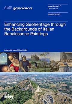
Cover Story (view full-size image): The ancient Duchy of Urbino (Central Italy) is known for its spectacular landscapes linked to a unique geological history. This area owns an unexpected cultural resource, which concerns using its landscapes in art. Some great Renaissance artists were so impressed by these landscapes that they reproduced them in their most famous paintings. Starting from the geological history of the territory, this paper summarizes research concerned with the identification of the backgrounds of famous works by three great Renaissance artists, providing evidence and morphological details related to the recognition of places, including the “Nativity” by Piero della Francesca, “Madonna Litta” by Leonardo da Vinci and “Knight’s Dream” by Raphael. Finally, we propose to make these landscapes a timeless resource through their inclusion in UNESCO’s cultural heritage. View this paper
  • Issues are regarded as officially published after their release is announced to the table of contents alert mailing list.
  • You may sign up for e-mail alerts to receive table of contents of newly released issues.
  • PDF is the official format for papers published in both, html and pdf forms. To view the papers in pdf format, click on the "PDF Full-text" link, and use the free Adobe Reader to open them.
Order results
Result details
Section
Select all
Export citation of selected articles as:
11 pages, 3056 KiB  
Article
Attenuating Anthropogenic Impact on Subterranean Micro-Climate: Insights from the Biospeleological Station in Postojna Cave
by Stanka Šebela and Uroš Novak
Geosciences 2024, 14(3), 87; https://doi.org/10.3390/geosciences14030087 - 21 Mar 2024
Viewed by 1733
Abstract
The Biospeleological Station (BS) in Postojna Cave, with a volume of 36,000 m3, has served as an underground biological laboratory since 1931, receiving 100,000 visitors annually. Historical cave micro-climate monitoring was performed in 1933 and 1963, and continuous monitoring of cave [...] Read more.
The Biospeleological Station (BS) in Postojna Cave, with a volume of 36,000 m3, has served as an underground biological laboratory since 1931, receiving 100,000 visitors annually. Historical cave micro-climate monitoring was performed in 1933 and 1963, and continuous monitoring of cave air temperature and carbon dioxide concentration at hourly intervals started in 2015. Micro-climatic data collected between 2015 and 2024 has helped us to understand the relationship between natural underground environment and anthropogenic impact, thereby aiding expert recommendations to cave managers for the mitigation of anthropogenic micro-climatic effects. Results strongly support the policy that, during summer, when outdoor temperatures are higher than in the cave, solid metal doors connecting the BS with the rest of the cave (Stara Jama) should be kept open. Such a simple mitigation act helps to decrease anthropogenically increased air temperature and carbon dioxide concentrations, thereby maintaining suitable micro-climatic conditions for the exhibition of cave animals. Closure during the COVID-19 pandemic (2020–2021) resulted in the lowest temperatures recorded. BS visitation increases air temperature by 1 °C, highlighting the need for management strategies to maintain suitable conditions for cave fauna exhibition. Full article
Show Figures

Figure 1

38 pages, 13171 KiB  
Article
Foraminiferal and Palynological Records of an Abrupt Environmental Change at the Badenian/Sarmatian Boundary (Middle Miocene): A Case Study in Northeastern Central Paratethys
by Danuta Peryt, Przemysław Gedl, Elżbieta Worobiec, Grzegorz Worobiec and Tadeusz Marek Peryt
Geosciences 2024, 14(3), 86; https://doi.org/10.3390/geosciences14030086 - 20 Mar 2024
Cited by 2 | Viewed by 1350
Abstract
The Badenian/Sarmatian boundary in the Central Paratethyan basins is characterised by a change from open marine conditions during the late Badenian to the assumed brackish conditions during the early Sarmatian. The foraminiferal and palynological results of the Badenian/Sarmatian boundary interval in the Babczyn [...] Read more.
The Badenian/Sarmatian boundary in the Central Paratethyan basins is characterised by a change from open marine conditions during the late Badenian to the assumed brackish conditions during the early Sarmatian. The foraminiferal and palynological results of the Badenian/Sarmatian boundary interval in the Babczyn 2 borehole (in SE Poland) showed that the studied interval accumulated under variable, unstable sedimentary conditions. The Badenian/Sarmatian boundary, as correlated with a sudden extinction of stenohaline foraminifera, is interpreted as being due to the shallowing of the basin. The lack of foraminifera and marine palynomorphs just above the Badenian/Sarmatian boundary can reflect short-term anoxia. The composition of the euryhaline assemblages, characteristic for the lower Sarmatian part of the studied succession, indicates from marine to hypersaline conditions. Full article
(This article belongs to the Section Biogeosciences)
Show Figures

Figure 1

30 pages, 13651 KiB  
Article
Assessments of Gravity Data Gridding Using Various Interpolation Approaches for High-Resolution Geoid Computations
by Onur Karaca, Bihter Erol and Serdar Erol
Geosciences 2024, 14(3), 85; https://doi.org/10.3390/geosciences14030085 - 19 Mar 2024
Viewed by 1635
Abstract
This article investigates the role of different approaches and interpolation methods in gridding terrestrial gravity anomalies. In this regard, first of all, simple and complete Bouguer anomalies are considered in gravity data gridding. In the comparison results of gridding these two Bouguer anomaly [...] Read more.
This article investigates the role of different approaches and interpolation methods in gridding terrestrial gravity anomalies. In this regard, first of all, simple and complete Bouguer anomalies are considered in gravity data gridding. In the comparison results of gridding these two Bouguer anomaly datasets, the effect of the high-frequency contribution of topographic gravitation (by means of the terrain correction) is clarified. After that, the role of the used interpolation algorithm on the resulting grid of mean gravity anomalies and hence on the geoid modeling accuracy is inspected. For this purpose, four different interpolation methods including geostatistical Kriging, nearest neighbor, inverse distance to a power (IDP), and artificial neural networks (ANNs) are applied. Here, the IDP and nearest neighbor methods represent simple-structured algorithms among the interpolation methods tested in this study. The ANN method, on the other hand, is preferred as a complex, optimization-based soft computing method that has been applied in recent years. In addition, the geostatistical Kriging method is one of the conventional methods that is mostly applied for gridding gravity data in geodesy and geophysics. The calculated gravity anomalies in grids are employed in high-resolution geoid model computations using the least squares modifications of Stokes formula with additive corrections (LSMSA) technique. The investigations are carried out using the test datasets of Auvergne, France that are provided by the International Service for the Geoid for scientific research. It is concluded that the interpolation algorithms affect the gravity gridding results and hence the geoid model determination. The ANN method does not provide superior results compared to the conventional algorithms in gravity gridding. The geoid model with 4.1 cm accuracy is computed in the test area. Full article
(This article belongs to the Special Issue Earth Observation by GNSS and GIS Techniques)
Show Figures

Figure 1

11 pages, 4124 KiB  
Article
On Segurasaurus (Squamata: Pythonomorpha), a New Genus of Lizard from the Cenomanian (Upper Cretaceous) of Portugal
by Mélani Berrocal-Casero, Ricardo Pimentel, Pedro Miguel Callapez, Fernando Barroso-Barcenilla and Senay Ozkaya de Juanas
Geosciences 2024, 14(3), 84; https://doi.org/10.3390/geosciences14030084 - 18 Mar 2024
Cited by 1 | Viewed by 2815
Abstract
Carentonosaurus soaresi was recently described in the uppermost middle Cenomanian (Upper Cretaceous) of Casais dos Carecos (Coimbra, western Portugal) based on a diverse set of new material (cervical and dorsal vertebrae) of the Pythonomorpha lizard. The main morphological characteristics observed in the vertebrae [...] Read more.
Carentonosaurus soaresi was recently described in the uppermost middle Cenomanian (Upper Cretaceous) of Casais dos Carecos (Coimbra, western Portugal) based on a diverse set of new material (cervical and dorsal vertebrae) of the Pythonomorpha lizard. The main morphological characteristics observed in the vertebrae used for the diagnosis of this species are the presence of distinct lateral and subcentral foramina, highly laterally projected paradiapophyses beyond the prezygapophyses, a low subrectangular neural spine ornamented with longitudinal grooves, and dorsal vertebrae displaying a sagittal furrow along the ventral surface. Additional diagnostic details observed both in new material and the previously studied vertebrae are described herein, such as the presence of keels in the zygantrum and zygosphene. These and other important morphological characteristics present in the species soaresi are absent in the genotype Carentonosaurus mineaui and in other known Squamata, allowing for the definition of the new genus Segurasaurus. Full article
(This article belongs to the Section Sedimentology, Stratigraphy and Palaeontology)
Show Figures

Figure 1

25 pages, 6333 KiB  
Article
Metallogeny and Genesis of Fault-Filling Barite-Sulfide Veins (Ougnat, Morocco): Petrography, Fluid Inclusion, and Sr-S Isotopic Constraints
by Samir Samaoui, Ayoub Aabi, Abdellah Boushaba, Belkasmi Mohammed, Abdellah Nait Bba, Abderrahim Essaifi, Lahssen Baidder and Othmane Lamrani
Geosciences 2024, 14(3), 83; https://doi.org/10.3390/geosciences14030083 - 18 Mar 2024
Cited by 2 | Viewed by 1701
Abstract
The Ougnat Massif of the eastern Anti-Atlas (Morocco) hosts barite and sulfide vein-type deposits of vital economic importance. With over 150 mineralized structures reported in the Ougnat Massif, the ore-bearing ones are predominantly composed of barite, quartz, calcite, and minor portions of sulfides. [...] Read more.
The Ougnat Massif of the eastern Anti-Atlas (Morocco) hosts barite and sulfide vein-type deposits of vital economic importance. With over 150 mineralized structures reported in the Ougnat Massif, the ore-bearing ones are predominantly composed of barite, quartz, calcite, and minor portions of sulfides. The mineralized veins are driven by NW-SE and NE-SW to E-W oblique-slip opening faults that cross both the Precambrian basement and its Paleozoic cover. The mineralized structures occur as lenses and sigmoidal veins that follow stepped tension fracture sets oblique to the fault planes. These geometries and kinematic indicators of these structures point to a predominantly normal-sinistral opening in a brittle-ductile tectonic setting. The S isotopic compositions of barite from the Ougnat Massif (+10.8 to +19.5‰) fall mostly within the range of δ34S values of Late Triassic to Jurassic seawater, thus suggesting that some of the SO2− in barite comes from seawater sulfate. This range of δ34S values also corresponds approximately to the hydrothermal barite context. The 87Sr/86Sr ratios of barite, which range from 0.710772 to 0.710816, lie between the radiogenic strontium isotopic compositions of deposition by hydrothermal solutions, and also coincide with the non-radiogenic isotopic signature of Triassic to Jurassic seawater. Based on a fluid inclusions study, the ore-forming fluids were a mixture of two or more fluids. A deep hot fluid with an average temperature of 368 °C leached the granodiorites and volcanic-sedimentary complex of the Ouarzazate Group. This fluid provided the hydrothermal system with most of the Ba, radiogenic Sr, and some of the dissolved S. A second, shallow fluid with an average temperature of 242 °C was derived from Late Triassic to Jurassic seawater. The barite mineralization of the Ougnat Massif constitutes a typical example of vein-type mineralization that occurred along the northern margin of the West African Craton and regionally tied to the central Atlantic opening. Full article
Show Figures

Figure 1

19 pages, 12210 KiB  
Article
Applications of Ground-Based Infrared Cameras for Remote Sensing of Volcanic Plumes
by Fred Prata, Stefano Corradini, Riccardo Biondi, Lorenzo Guerrieri, Luca Merucci, Andrew Prata and Dario Stelitano
Geosciences 2024, 14(3), 82; https://doi.org/10.3390/geosciences14030082 - 17 Mar 2024
Cited by 1 | Viewed by 1568
Abstract
Ground-based infrared cameras can be used effectively and safely to provide quantitative information about small to moderate-sized volcanic eruptions. This study describes an infrared camera that has been used to measure emissions from the Mt. Etna and Stromboli (Sicily, Italy) volcanoes. The camera [...] Read more.
Ground-based infrared cameras can be used effectively and safely to provide quantitative information about small to moderate-sized volcanic eruptions. This study describes an infrared camera that has been used to measure emissions from the Mt. Etna and Stromboli (Sicily, Italy) volcanoes. The camera provides calibrated brightness temperature images in a broadband (8–14 µm) channel that is used to determine height, plume ascent rate and volcanic cloud/plume temperature and emissivity at temporal sampling rates of up to 1 Hz. The camera can be operated in the field using a portable battery and includes a microprocessor, data storage and WiFi. The processing and analyses of the data are described with examples from the field experiments. The updraft speeds of the small eruptions at Stromboli are found to decay with a timescale of ∼10 min and the volcanic plumes reach thermal equilibrium within ∼2 min. A strong eruption of Mt. Etna on 1 April 2021 was found to reach ∼9 km, with ascent speeds of 10–20 ms−1. The plume, mostly composed of the gases CO2, water vapour and SO2, became bent over by the prevailing winds at high levels, demonstrating the need for multiple cameras to accurately infer plume heights. Full article
Show Figures

Figure 1

15 pages, 24046 KiB  
Article
Selected Geoheritage Resources of “Atlantic Geopark” Project (Central Portugal)
by Salomé C. Custódio, Maria Helena Henriques, Emmaline M. Rosado-González, Nuno M. Vaz and Artur A. Sá
Geosciences 2024, 14(3), 81; https://doi.org/10.3390/geosciences14030081 - 16 Mar 2024
Cited by 1 | Viewed by 1932
Abstract
The “Atlantic Geopark” Project corresponds to the first stage of a broad project addressing a future application to the Global Geopark Network of a territory located in Portugal: “The Atlantic Geopark: 600 million of geological history”. It covers six central littoral and rural [...] Read more.
The “Atlantic Geopark” Project corresponds to the first stage of a broad project addressing a future application to the Global Geopark Network of a territory located in Portugal: “The Atlantic Geopark: 600 million of geological history”. It covers six central littoral and rural municipalities (Cantanhede, Figueira da Foz, Mealhada, Mira, Montemor-o-Velho, and Penacova), which display special and singular geodiversity, and it includes geological heritage with international relevance representing the opening and closing of the Rheic Ocean, the formation and breakup of Pangea, and the opening of the North Atlantic Ocean. Besides the geological heritage, here presented through the description and characterization of six geological sites (one per municipality) which served as anchors for the development of the project currently underway, the territory also provides other geoheritage resources related to uses of the local geological features. These resources hold significance in bolstering an application to the Global Geopark Network soon. They encompass partially artificial elements such as road excavations, agricultural soils, and quarries, as well as entirely artificial elements such as interpretation centers and museums. These elements serve as tangible representations of the various ways in which the Earth and local communities interact. Full article
(This article belongs to the Section Geoheritage, Geoparks and Geotourism)
Show Figures

Figure 1

23 pages, 6179 KiB  
Article
Fabrication and Mechanical Evaluation of Eco-Friendly Geopolymeric Mortars Derived from Ignimbrite and Demolition Waste from the Construction Industry in Peru
by Fredy Alberto Huamán-Mamani, Cris Katherin Palomino-Ñaupa, María del Mar Orta Cuevas and Santiago Medina-Carrasco
Geosciences 2024, 14(3), 80; https://doi.org/10.3390/geosciences14030080 - 15 Mar 2024
Viewed by 1556
Abstract
Ignimbrite rock is a volcanic material located in the Arequipa region (Peru), and for centuries, it has been used as a construction material, giving a characteristic light pastel, white to pink color to the city of Arequipa, with white being the most common. [...] Read more.
Ignimbrite rock is a volcanic material located in the Arequipa region (Peru), and for centuries, it has been used as a construction material, giving a characteristic light pastel, white to pink color to the city of Arequipa, with white being the most common. In the present study, the potential use of three types of Arequipa raw materials (ignimbrite rock powder, calcined clay powder, and demolition mortar powder) as the main source of new binders or the manufacture of environmentally friendly mortars, without the addition of ordinary Portland cement (OPC) is discussed. In this work, an in-depth characterization of the materials used was carried out. The proposed fabrication route for geopolymeric materials was considered for the manufacture of binders and mortars using an alkaline solution of NaOH with values between 12 and 18 molar, as a trigger for the geopolymerization process. Geopolymeric mortars were obtained by adding a controlled amount of fine sand to the previously prepared mixture of binder raw material and an alkaline solution. Conventional OPC and geopolymeric mortars manufactured under the same conditions were mechanically evaluated by uniaxial compression tests at a constant compression rate of 0.05 mm/min and under normal conditions of temperature and atmosphere, where the most optimal values were obtained for 15 molar alkaline solutions of ignimbrite without the addition of aggregates, with values of compressive strength of 42 MPa and a modulus elastic of 30 GPa. The results revealed a significant increase in the maximum strength and modulus of elasticity values when the volumetric fractions of OPC are completely replaced with geopolymeric binders in the study conditions of this work, demonstrating the enormous potential of the ignimbrite rock and construction waste studied, as raw material of alternative mortar binders without the addition of OPC. With this work, the ignimbrite rock, of great value in the region and also found in other areas of the Earth’s geography, was characterized and valued, in addition to the calcined clay and demolition mortar of the region. Full article
(This article belongs to the Section Geomechanics)
Show Figures

Graphical abstract

13 pages, 4902 KiB  
Article
Lineament Domain Analysis to Unravel Tectonic Settings on Planetary Surfaces: Insights from the Claritas Fossae (Mars)
by Evandro Balbi and Fabrizio Marini
Geosciences 2024, 14(3), 79; https://doi.org/10.3390/geosciences14030079 - 15 Mar 2024
Cited by 3 | Viewed by 1434
Abstract
Linear geo-textures are widely recognized on synthetic scaled images of planetary surfaces and consist of elongated alignments of tonal contrasts. When these linear patterns are clustered in azimuthal sets and organized in domains occurring on specific terranes, they reflect the structural grain of [...] Read more.
Linear geo-textures are widely recognized on synthetic scaled images of planetary surfaces and consist of elongated alignments of tonal contrasts. When these linear patterns are clustered in azimuthal sets and organized in domains occurring on specific terranes, they reflect the structural grain of the crust and provide clues on the stress trajectories. In this way, the geostatistical analysis of lineament domains represents a useful tool to highlight the geotectonic settings of planetary surfaces. In this work, we applied a lineament domain analysis to better frame the tectonic evolution of the Claritas Fossae (CF) area on Mars, the origin of which is still debated, and both dip–slip and strike–slip tectonics have been described in the literature. A twofold approach was followed that included the identification of a linear pattern with manual and automatic approaches. The automatic method confirmed and validated the results of the manual detection. The statistical analysis of the identified lineaments showed their clustering in two domains that persisted on different terranes separated by the regionally sized scarp associated with the CF. This scarp is the surface manifestation of the CF crustal fault. The spatial distribution of the two domains and their constant angular relationship of about 30° allowed relating one domain to the main CF fault and the other domain to the extensional deformation associated with the fault kinematics. Our results suggest that the CF frames well within a regional setting characterized by right–lateral kinematics with about 20% transtension. Temporal constraints derive from the ages of the terrains where the two domains develop. On this basis, we propose that a first tectonic event occurred in the Noachian age followed by a reactivation occurring after the emplacement of the Late Hesperian lavas. Full article
(This article belongs to the Special Issue Landscape Evolution in Tectonically Active Regions)
Show Figures

Figure 1

30 pages, 38126 KiB  
Article
Soil Erosion Modeling Using the Revised Universal Soil Loss Equation and a Geographic Information System in a Watershed in the Northeastern Brazilian Cerrado
by Wellynne Carla de Sousa Barbosa, Antonio José Teixeira Guerra and Gustavo Souza Valladares
Geosciences 2024, 14(3), 78; https://doi.org/10.3390/geosciences14030078 - 14 Mar 2024
Cited by 1 | Viewed by 1657
Abstract
Soils have an important task in maintaining vegetation cover and natural resources on Earth and are indispensable to societies. However, the accelerated soil erosion has become an environmental problem related to land settlement for agricultural practices and forestry and is linked to population [...] Read more.
Soils have an important task in maintaining vegetation cover and natural resources on Earth and are indispensable to societies. However, the accelerated soil erosion has become an environmental problem related to land settlement for agricultural practices and forestry and is linked to population growth. This study aimed to evaluate soil erosion in a watershed downstream of Parnaíba river, northwest of Piauí state, in the Brazilian Cerrado using geotechnology products and tools in order to understand the soil loss and map the potential erosion and actual erosion through qualitative and quantitative results to support the management and planning of the watershed in an effective and efficient way. As a modeling tool, this research used the Revised Universal Soil Loss Equation (RUSLE). The potential erosion ranged from very low to very high. The soil loss obtained by the integration of natural physical factors with land use (anthropic action) resulted in soil loss corresponding to the category slight (0–0.01 t.ha−1.year−1) to extremely high (>100 t.ha−1.year−1). The areas with the greatest soil loss were identified in land uses linked to pasture, exposed soil, and cultivated land. It was also possible to identify erosion features in the field, indicating the need to implement soil conservation practices. Full article
(This article belongs to the Special Issue Soil Erosion Processes)
Show Figures

Figure 1

23 pages, 7549 KiB  
Article
Characterizing Dissolved Organic Matter and Other Water-Soluble Compounds in Ground Ice of the Russian Arctic: A Focus on Ground Ice Classification within the Carbon Cycle Context
by Petr Semenov, Anfisa Pismeniuk, Anna Kil, Elizaveta Shatrova, Natalia Belova, Petr Gromov, Sergei Malyshev, Wei He, Anastasiia Lodochnikova, Ilya Tarasevich, Irina Streletskaya and Marina Leibman
Geosciences 2024, 14(3), 77; https://doi.org/10.3390/geosciences14030077 - 13 Mar 2024
Viewed by 1638
Abstract
Climate-induced changes contribute to the thawing of ice-rich permafrost in the Arctic, which leads to the release of large amounts of organic carbon into the atmosphere in the form of greenhouse gases, mainly carbon dioxide and methane. Ground ice constitutes a considerable volume [...] Read more.
Climate-induced changes contribute to the thawing of ice-rich permafrost in the Arctic, which leads to the release of large amounts of organic carbon into the atmosphere in the form of greenhouse gases, mainly carbon dioxide and methane. Ground ice constitutes a considerable volume of the cryogenically sequestered labile dissolved organic carbon (DOC) subjected to fast mineralization upon thawing. In this work, we collected a unique geochemical database of the ground and glacier ice comprising the samples from various geographic locations in the Russian Arctic characterized by a variety of key parameters, including ion composition, carbon-bearing gases (methane and carbon dioxide), bulk biogeochemical indicators, and fluorescent dissolved organic matter (DOM) fractions. Our results show that interaction with solid material—such as sediments, detritus, and vegetation—is likely the overriding process in enrichment of the ground ice in all the dissolved compounds. Terrigenous humic-like dissolved organic matter was predominant in all the analyzed ice samples except for glacier ice from Bolshevik Island (the Severnaya Zemlya archipelago) and pure (with low sediment content) tabular ground ice from western Yamal. The labile protein-like DOM showed no correlation to humic components and was probably linked to microbial abundance in the ground ice. The sum of the fluorophores deconvoluted by PARAFAC strongly correlates to DOC, which proves the potential of using this approach for differentiation of bulk DOC into fractions with various origins and biogeochemical behaviors. The pure tabular ground ice samples exhibit the highest rate of fresh easily degradable DOM in the bulk DOC, which may be responsible for the amplification of permafrost organic matter decomposition upon thawing. Full article
(This article belongs to the Section Cryosphere)
Show Figures

Figure 1

24 pages, 22235 KiB  
Article
The Backgrounds of Renaissance Paintings in the Ancient Duchy of Urbino (Central Italy): Exploring New Forms of Valorization of Geoheritage through Their Inclusion in UNESCO Cultural Landscapes
by Olivia Nesci, Rosetta Borchia and Laura Valentini
Geosciences 2024, 14(3), 76; https://doi.org/10.3390/geosciences14030076 - 13 Mar 2024
Viewed by 1737
Abstract
The ancient Duchy of Urbino (Marche and Emilia-Romagna Regions, Italy) is known for its spectacular landscapes linked to a unique geological history. This area owns an unexpected cultural resource, which concerns using its landscapes in art. Some great Renaissance artists, including Piero della [...] Read more.
The ancient Duchy of Urbino (Marche and Emilia-Romagna Regions, Italy) is known for its spectacular landscapes linked to a unique geological history. This area owns an unexpected cultural resource, which concerns using its landscapes in art. Some great Renaissance artists, including Piero della Francesca, Raphael, and Leonardo, were so impressed by the landscapes that they reproduced them in their most famous paintings. This paper summarizes research concerned with their identification, employing a multidisciplinary method that has enabled the recognition of many morphologies. This contribution provides the scientific community with information on the methodology and regional and national projects developed in this area to enhance its cultural landscapes. Starting from the geological description of the territory, the research focuses on famous works by three great Renaissance artists, providing evidence and morphological details related to the recognition of places: “Nativity” by Piero della Francesca, “Madonna Litta” by Leonardo da Vinci, and “Knight’s Dream” by Raphael. Finally, it is proposed to make these landscapes a timeless resource through their inclusion in UNESCO’s cultural heritage. This contribution is addressed to representatives of the administration, conservation, and enhancement of artistic and landscape heritage to stimulate new perspectives for research, education, and tourism within the cultural heritage of this area. Full article
(This article belongs to the Section Geoheritage, Geoparks and Geotourism)
Show Figures

Figure 1

17 pages, 3961 KiB  
Article
Assessment of Unmanned Aerial System Flight Plans for Data Acquisition from Erosional Terrain
by Valentina Nikolova, Veselina Gospodinova and Asparuh Kamburov
Geosciences 2024, 14(3), 75; https://doi.org/10.3390/geosciences14030075 - 12 Mar 2024
Viewed by 1239
Abstract
Accurate data mapping and visualization are of crucial importance for the detection and monitoring of slope morphodynamics, including erosion processes and studying small erosional landforms (rills and gullies). The purpose of the current research is to examine how the flight geometry of unmanned [...] Read more.
Accurate data mapping and visualization are of crucial importance for the detection and monitoring of slope morphodynamics, including erosion processes and studying small erosional landforms (rills and gullies). The purpose of the current research is to examine how the flight geometry of unmanned aerial systems (UASs) could affect the accuracy of photogrammetric processing products, concerning small erosion landforms that are a result of slope wash and temporary small streams formed by rain. In October 2021, three UAS flights with a different geometry were carried out in a hilly to a low-mountain area with an average altitude of about 650 m where erosion processes are observed. UAS imagery processing was carried out using structure-from-motion (SfM) photogrammetry. High-resolution products such as photogrammetric-based point clouds, digital surface models (DSMs) and orthophotos were generated. The obtained data were compared and evaluated by the root mean square error (RMSE), length measurement, cloud-to-cloud comparison, and 3D spatial GIS analysis of DSMs. The results show small differences between the considered photogrammetric products generated by nadir-viewing and oblique-viewing (45°—single strip and 60°—cross strips) geometry. The complex analysis of the obtained photogrammetric products gives an advantage to the 60°—cross strips imagery, in studying erosional terrains with slow slope morphodynamics. Full article
(This article belongs to the Special Issue Earth Observation by GNSS and GIS Techniques)
Show Figures

Figure 1

14 pages, 11098 KiB  
Article
Inventory of Landslides in the Northern Half of the Taihang Mountain Range, China
by Xuewei Zhang, Chong Xu, Lei Li, Liye Feng and Wentao Yang
Geosciences 2024, 14(3), 74; https://doi.org/10.3390/geosciences14030074 - 10 Mar 2024
Cited by 2 | Viewed by 1423
Abstract
The Taihang Mountains are a critical mountain range and geographical boundary in eastern China. Landslide disasters are particularly common in this region and usually cause serious casualties and property damage. However, previous landslide inventories in the region are limited and lack comprehensive landslide [...] Read more.
The Taihang Mountains are a critical mountain range and geographical boundary in eastern China. Landslide disasters are particularly common in this region and usually cause serious casualties and property damage. However, previous landslide inventories in the region are limited and lack comprehensive landslide cataloguing. To address this gap, the northern half of the Taihang Mountain Range was selected for this study. A landslide database for the area was constructed using multi-temporal high-resolution optical imagery from the Google Earth and human–computer interactive visual interpretation technology. The results indicate that at least 8349 landslides have occurred in the Taihang Mountain Range, with a total landslide area of about 151.61 km2. The size of the landslides varies, averaging about 18,159.23 m2, with the largest landslide covering 2.83 km2 and the smallest landslide only 5.95 m2. The significance of this study lies in its ability to enhance our understanding of the distribution of landslides in the northern half of the Taihang Mountains. Furthermore, it offers valuable data references and supports for landslide assessment, early warning systems, disaster management, and ecological protection efforts. Full article
Show Figures

Figure 1

15 pages, 2454 KiB  
Article
Thermal Anomalies Observed during the Crete Earthquake on 27 September 2021
by Soujan Ghosh, Sudipta Sasmal, Sovan K. Maity, Stelios M. Potirakis and Masashi Hayakawa
Geosciences 2024, 14(3), 73; https://doi.org/10.3390/geosciences14030073 - 9 Mar 2024
Cited by 2 | Viewed by 1545
Abstract
This study examines the response of the thermal channel within the Lithosphere–Atmosphere–Ionosphere Coupling (LAIC) mechanism during the notable earthquake in Crete, Greece, on 27 September 2021. We analyze spatio-temporal profiles of Surface Latent Heat Flux (SLHF), Outgoing Longwave Radiation (OLR), and Atmospheric Chemical [...] Read more.
This study examines the response of the thermal channel within the Lithosphere–Atmosphere–Ionosphere Coupling (LAIC) mechanism during the notable earthquake in Crete, Greece, on 27 September 2021. We analyze spatio-temporal profiles of Surface Latent Heat Flux (SLHF), Outgoing Longwave Radiation (OLR), and Atmospheric Chemical Potential (ACP) using reanalysis data from the National Oceanic and Atmospheric Administration (NOAA) satellite. Anomalies in these parameters are computed by removing the background profile for a non-seismic condition. Our findings reveal a substantial anomalous increase in these parameters near the earthquake’s epicenter 3 to 7 days before the main shock. The implications of these observations contribute to a deeper understanding of the LAIC mechanism’s thermal channel in seismic events. Full article
Show Figures

Figure 1

10 pages, 903 KiB  
Communication
The Possibility of Estimating the Permafrost’s Porosity In Situ in the Hydrocarbon Industry and Environment
by Lev V. Eppelbaum
Geosciences 2024, 14(3), 72; https://doi.org/10.3390/geosciences14030072 - 9 Mar 2024
Viewed by 1334
Abstract
Global warming firstly influences the permafrost regions where numerous and rich world hydrocarbon deposits are located. Permafrost thawing has caused severe problems in exploring known hydrocarbon deposits and searching for new targets. This process is also dangerous for any industrial and living regions [...] Read more.
Global warming firstly influences the permafrost regions where numerous and rich world hydrocarbon deposits are located. Permafrost thawing has caused severe problems in exploring known hydrocarbon deposits and searching for new targets. This process is also dangerous for any industrial and living regions in cold regions. Knowledge of permafrost’s ice and unfrozen water content is critical for predicting permafrost behavior during the water–ice transition. This is especially relevant when ice and permafrost are melting in many regions under the influence of global warming. It is well known that only part of the formation’s pore water turns into ice at 0 °C. After further lowering the temperature, the water phase transition continues, but at gradually decreasing rates. Thus, the porous space is filled with ice and unfrozen water. Laboratory data show that frozen formations’ mechanical, thermal, and rheological properties strongly depend on the moisture content. Hence, porosity and temperature are essential parameters of permafrost. In this paper, it is shown that by combining research in three fields, (1) geophysical exploration, (2) numerical modeling, and (3) temperature logging, it is possible to estimate the porosity of permafrost in situ. Five examples of numerical modeling (where all input parameters are specified) are given to demonstrate the procedure. This investigation is the first attempt to quantitatively analyze permafrost’s porosity in situ. Full article
Show Figures

Figure 1

17 pages, 18064 KiB  
Article
Real-Time Automated Geosteering Interpretation Combining Log Interpretation and 3D Horizon Tracking
by John D’Angelo, Zeyu Zhao, Yifan Zhang, Pradeepkumar Ashok, Dongmei Chen and Eric van Oort
Geosciences 2024, 14(3), 71; https://doi.org/10.3390/geosciences14030071 - 9 Mar 2024
Viewed by 1698
Abstract
Existing methods for estimating formation boundaries from well-log data only analyze the formation along the wellbore, failing to capture changes in the 3D formation structure around it. This paper presents a method for real-time 3D formation boundary interpretation using readily available well logs [...] Read more.
Existing methods for estimating formation boundaries from well-log data only analyze the formation along the wellbore, failing to capture changes in the 3D formation structure around it. This paper presents a method for real-time 3D formation boundary interpretation using readily available well logs and seismic image data. In the proposed workflow, the mean formation boundary is estimated as a curve following the well path. 3D surfaces are then fitted through this boundary curve, aligning with the slopes and features in the seismic image data. The proposed method is tested on both synthetic and field datasets and illustrates the capabilities of accurate boundary estimation near the well path and precise representation of boundary shape changes further away from the well trajectory. With this fully automated geological interpretation workflow, human bias and interpretation uncertainty can be minimized. Subsurface conditions can be continually updated while drilling to optimize drilling decisions and further automate the geosteering process. Full article
Show Figures

Figure 1

20 pages, 6830 KiB  
Review
An Analytical Review of the Recent Crustal Uplifts, Tectonics, and Seismicity of the Caucasus Region
by Vladimir I. Kaftan, Alexei D. Gvishiani, Alexander I. Manevich, Boris A. Dzeboev, Viktor N. Tatarinov, Boris V. Dzeranov, Alina M. Avdonina and Iliya V. Losev
Geosciences 2024, 14(3), 70; https://doi.org/10.3390/geosciences14030070 - 7 Mar 2024
Viewed by 1508
Abstract
This paper analyzes and reviews the rapid uplifts of the Earth’s crust in the Caucasus that occurred over the last century. The uplifts were registered by precise repeated state leveling and reflected on officially published maps of vertical movements of the Earth’s crust. [...] Read more.
This paper analyzes and reviews the rapid uplifts of the Earth’s crust in the Caucasus that occurred over the last century. The uplifts were registered by precise repeated state leveling and reflected on officially published maps of vertical movements of the Earth’s crust. This study summarizes information on the region’s vertical movements over more than a century. The present study describes the technology for creating maps of recent vertical movements of the Earth’s crust using precision leveling data. This paper summarizes cases of recording uplifts of the Earth’s surface in other regions of the world in connection with seismic activity. The authors carried out intercomparison of vertical movements with tectonics, seismicity, and geophysical fields, which discovered their apparent mutual correspondence. This indicates the deep tectonic nature of the observed uplifts of the Earth’s crust. Spatial and temporal agreement with the distribution of strong earthquakes showed a natural relationship. It has been shown that strong earthquakes are confined to the boundaries of zones of rapid uplift. They occur predominantly in areas of transition between uplifts and subsidence. The results obtained demonstrate the role of the study and observations of vertical movements of the Caucasus in assessing periods and areas of increased seismic hazard. Full article
(This article belongs to the Special Issue Precursory Phenomena Prior to Earthquakes 2023)
Show Figures

Figure 1

18 pages, 5038 KiB  
Article
Late Cretaceous Tectono-Metamorphic Events in the Skyros Upper Metamorphic Unit (Olympus Mountain), Aegean Sea, Greece
by Dimitra Boundi, Dimitrios Papanikolaou, Giulia Bosio and Chiara Montemagni
Geosciences 2024, 14(3), 69; https://doi.org/10.3390/geosciences14030069 - 5 Mar 2024
Viewed by 1521
Abstract
Late Cretaceous metamorphic events are known in Crete and the Cyclades from klippen above the External Hellenides. This work extends their occurrence to the North Aegean area within the tectonic units of the Internal Hellenides. New 40Ar/39Ar white mica ages [...] Read more.
Late Cretaceous metamorphic events are known in Crete and the Cyclades from klippen above the External Hellenides. This work extends their occurrence to the North Aegean area within the tectonic units of the Internal Hellenides. New 40Ar/39Ar white mica ages from garnet-bearing micaschists of the Upper Metamorphic Unit of Skyros Island, cropping out in the Skyrian Olympus Mountain, document a Late Cretaceous tectono-metamorphic evolution. Several mica generations have been distinguished using electron probe microanalyses and were dated using the 40Ar/39Ar method: a relict mica older than 96 Ma, followed by a foliation-forming mica of about 88–84 Ma and alteration phases ≤ 68 Ma were recognized. This Cretaceous tectono-metamorphic evolution falls between the closure of the internal Axios/Vardar oceanic basin in the Late Jurassic–Early Cretaceous, and the closure of the external Pindos–Cyclades oceanic basin in the Early Cenozoic. The position of the Upper Metamorphic Unit of Skyros was probably within the evolving Hellenic volcanic/magmatic arc during the continuous subduction of the African plate beneath the European plate. The present tectonic position of the units bearing the Late Cretaceous metamorphic event is the result of the Cenozoic tectonic emplacement onto the more external units across the Hellenides from the Pelagonian to the Pindos–Cyclades domain. Full article
(This article belongs to the Section Structural Geology and Tectonics)
Show Figures

Figure 1

42 pages, 8069 KiB  
Review
Definitions, Classification Schemes for Active Faults, and Their Application
by Zhonghai Wu and Mengmeng Hu
Geosciences 2024, 14(3), 68; https://doi.org/10.3390/geosciences14030068 - 4 Mar 2024
Cited by 2 | Viewed by 2978
Abstract
Active faults are generally defined as faults that have moved in the past and will continue to be active in the future. They are expected to cause deformation and potential disasters if they are localized close to human activities. The definition and classification [...] Read more.
Active faults are generally defined as faults that have moved in the past and will continue to be active in the future. They are expected to cause deformation and potential disasters if they are localized close to human activities. The definition and classification of active faults are important bases for evaluating the risk. This paper summarizes and compares the history, status, and progress of their definition and classification schemes used in representative countries and regions, as well as in some relevant standards, in active fault mapping, in the construction of spatial databases, and in some other aspects. It is concluded that the current geodynamic setting, existing technical means, geological operability, application purpose, and social acceptability of active faulting hazard in a specific area comprehensively determine the selection of the definition and classification. The key parameter in defining active faults is the time limit. It usually involves four time scales, i.e., Neotectonic (post-Neogene), Quaternary, Late Quaternary, and Holocene. The definition using a short time scale, such as Late Quaternary and Holocene, is usually suitable for the plate boundary zone, which has a high strain rate, but active faults in the intraplate deformation region and stable continental region should be defined with a long time scale, such as the Quaternary and Neotectonics. In addition, the magnitude standard can determine the activity intensity of active faults, which most generally includes three classes, namely, M ≥ 5.0 damaging earthquakes, M ≥ 6.0 strong earthquakes, and M ≥ 6.5 earthquakes that may produce surface displacement or deformation. The M ≥ 5.0 earthquake is generally applicable to regional earthquake prevention and risk mitigation in many countries or regions, but the M ≥ 6.5 earthquake magnitude benchmark is generally used as the standard in rules or regulations regarding active fault avoidance. The most common classification schemes in many countries or regions are based on fault activity, which is reflected mainly by the fault slip rate and fault recurrence interval (FRI), as well as by the last activation time. However, when determining the specific quantitative parameters of the different activity levels of faults, it is necessary to comprehensively consider the differences in activity and ages of the faults in the study region, as well as the amount and validity of existing data for the purpose of classifying different active levels of faults effectively. Full article
(This article belongs to the Special Issue Active Tectonics and Earthquakes)
Show Figures

Figure 1

31 pages, 11489 KiB  
Article
Algorithmic Geology: Tackling Methodological Challenges in Applying Machine Learning to Rock Engineering
by Beverly Yang, Lindsey J. Heagy, Josephine Morgenroth and Davide Elmo
Geosciences 2024, 14(3), 67; https://doi.org/10.3390/geosciences14030067 - 4 Mar 2024
Viewed by 1934
Abstract
Technological advancements have made rock engineering more data-driven, leading to increased use of machine learning (ML). While the use of ML in rock engineering has the potential to transform the industry, several methodological issues should first be addressed: (i) rock engineering’s use of [...] Read more.
Technological advancements have made rock engineering more data-driven, leading to increased use of machine learning (ML). While the use of ML in rock engineering has the potential to transform the industry, several methodological issues should first be addressed: (i) rock engineering’s use of biased (poor quality) data, resulting in biased ML models and (ii) limited rock mass classification and characterization data. If these issues are not addressed, rock engineering risks using unreliable ML models that can have potential real-life adverse impacts. This paper aims to provide an overview of these methodological issues and demonstrate their impact on the reliability of ML models using surrogate models. To take full advantage of the benefits of ML, rock engineers should make sure that their ML models are reliable by ensuring that there are sufficient unbiased data to develop reliable ML models. In the context of this paper, the term sufficient retains a relative meaning since the amount of data that is sufficient to develop reliable a ML models depends on the problem under consideration and the application of the ML model (e.g., pre-feasibility, feasibility, design stage). Full article
(This article belongs to the Special Issue Machine Learning in Engineering Geology)
Show Figures

Figure 1

21 pages, 5458 KiB  
Technical Note
Issues of Bias in Groundwater Quality Data Sets in an Irrigated Floodplain Aquifer of Variable Salinity
by Barry J. Hibbs, Christopher J. Eastoe and Mercedes Merino
Geosciences 2024, 14(3), 66; https://doi.org/10.3390/geosciences14030066 - 4 Mar 2024
Viewed by 1486
Abstract
In arid regions characterized by large variations in groundwater salinity, the data derived from irrigation and domestic water supply wells may exhibit bias, reflecting an overall lower salinity than the true aquifer distribution. This bias stems from the decommissioning, non-use, or disrepair of [...] Read more.
In arid regions characterized by large variations in groundwater salinity, the data derived from irrigation and domestic water supply wells may exhibit bias, reflecting an overall lower salinity than the true aquifer distribution. This bias stems from the decommissioning, non-use, or disrepair of wells that are frequently sources of higher salinity readings, rendering them unavailable for sampling. Baseflow-fed streams, agricultural drains, seeps, springs issuing into agricultural drains, and randomly located test hole samples tend to manifest higher averages and ranges of salinity when compared to supply wells. Agricultural drain flows, springs, and test holes, if sampled following recommended guidelines, are less susceptible to such bias. This study presents a case of groundwater bias identified through an initial water well sampling program in El Paso (Texas, USA). Subsequent rounds of sampling, incorporating drain samples, spring samples, and test hole samples, revealed a more comprehensive understanding of the salinity dynamics. The dataset not only highlights the existence of bias but also provides evidence for a combined geological and agricultural origin of salinity. Additionally, it demonstrates that drain sampling in an earlier study did not accurately depict a primary salinity source due to incomplete analysis of the data. Recommendations are outlined to mitigate bias, emphasizing the importance of sample control from baseflow-fed drains, springs, water wells, and test hole samples. The study also infers the upwelling of saline groundwater from deeper formations in the study area, contributing to a more comprehensive understanding of groundwater salinity dynamics. Full article
(This article belongs to the Special Issue Groundwater in Arid and Semiarid Areas II)
Show Figures

Figure 1

21 pages, 3102 KiB  
Article
When the Past Teaches the Future: Earthquake and Tsunami Risk Reduction through Episodes of Situated Learning (ESL)
by Giovanna Lucia Piangiamore and Alessandra Maramai
Geosciences 2024, 14(3), 65; https://doi.org/10.3390/geosciences14030065 - 26 Feb 2024
Viewed by 1584
Abstract
The past offers important lessons with regard to facing the future with greater awareness. In this context, school plays a key role in spreading knowledge of natural phenomena and in promoting behavior change. Together with researchers, teachers can be strong allies to build [...] Read more.
The past offers important lessons with regard to facing the future with greater awareness. In this context, school plays a key role in spreading knowledge of natural phenomena and in promoting behavior change. Together with researchers, teachers can be strong allies to build more resilient future citizens. The Istituto Nazionale di Geofisica e Vulcanologia (INGV) school training activities provide tools to prepare for the next earthquake and/or tsunami. Approximately 5000 students, from both middle schools (ISCED 2) and high schools (ISCED 3), were involved in active learning activities based on a flipped-up approach during specific online scientific events during the pandemic. Online lab activities were conducted during European Researchers’ Night (“Earthquakes: history teaches us the future: researchers for a day with experimentation in didactics for ESL”) and during both World Water Day 2021 and World Earth Day 2021 (“Tsunamis: history teaches us the future researchers for a day with experimentation in didactics for ESL”). These two Episodes of Situated Learning (ESL) experiences triggered students’ interest, favoring remote learning, developing life skills, and focusing on historical seismic studies of both past earthquakes and tsunamis. Full article
(This article belongs to the Special Issue Seismic Hazard Assessment and Earthquake Risk Mitigation)
Show Figures

Figure 1

23 pages, 27417 KiB  
Article
Comparison of the Piezocone Penetrometer (CPTU) and Flat Dilatometer (DMT) Methods for Landslide Characterisation
by Kristijan Grabar, Jasmin Jug, Anja Bek and Stjepan Strelec
Geosciences 2024, 14(3), 64; https://doi.org/10.3390/geosciences14030064 - 26 Feb 2024
Cited by 1 | Viewed by 1480
Abstract
The increasing occurrence of landslides worldwide causes many human casualties and huge socio-economic losses. Therefore, the fastest and most accurate characterisation of landslides is important. The objective of this study is to compare how well the flat dilatometer (DMT) test and the piezocone [...] Read more.
The increasing occurrence of landslides worldwide causes many human casualties and huge socio-economic losses. Therefore, the fastest and most accurate characterisation of landslides is important. The objective of this study is to compare how well the flat dilatometer (DMT) test and the piezocone penetration (CPTU) test can find the depth of a sliding zone. Inclinometers were used to measure horizontal changes in the soil to ensure the depth of the sliding zone was correct. The coincidence of the results of in situ static probes, and the displacements of the inclinometers is a sure confirmation of the depth of the sliding zone. In the example of Bedekovčina and Kravarsko landslides, in situ static probes were used to obtain values of input parameters on the sliding zone for parametric sensitivity analysis of parameters. Sensitivity analysis was performed by plotting the relationship between the above parameters and the vertical effective stress σ′vo on the sliding zone. The sensitivity analysis of the parameters of 11 tested samples shows that for the parameters of the obtained DMT probe, a higher sensitivity of the parameters is obtained, closer to the values concerning the expected range, and a minor standard deviation. The parameter Kd obtained by dilatometer probing is the best indicator of the depth of the sliding zone. The literature value Kd = 1.8–2.0 on the sliding zone in this paper is extended to the range Kd = 1.8–2.5, and its detection sensitivity is influenced by over-consolidation in shallow soil layers. In general, the research results show that the dilatometer probe has an advantage over the piezocone penetrometer test for the needs of landslide characterisation. Full article
(This article belongs to the Topic Geotechnics for Hazard Mitigation)
Show Figures

Figure 1

19 pages, 7120 KiB  
Article
The Magmatic Patterns Formed by the Interaction of the Hainan Mantle Plume and Lei–Qiong Crust Revealed through Seismic Ambient Noise Imaging
by Mohan Pan, Ting Yang, Ba Manh Le, Yuhang Dai and Han Xiao
Geosciences 2024, 14(3), 63; https://doi.org/10.3390/geosciences14030063 - 25 Feb 2024
Cited by 1 | Viewed by 1616
Abstract
Magmatism on continental lithospheres induced by mantle plumes is more complex compared to oceanic intraplate volcanism owing to the heterogeneous nature of continental crustal and lithospheric structures. Substantial evidence points to the deep-oriented Hainan mantle plume beneath the Lei–Qiong region, the southernmost of [...] Read more.
Magmatism on continental lithospheres induced by mantle plumes is more complex compared to oceanic intraplate volcanism owing to the heterogeneous nature of continental crustal and lithospheric structures. Substantial evidence points to the deep-oriented Hainan mantle plume beneath the Lei–Qiong region, the southernmost of the South China block. In this study, we present a detailed shear wave velocity model of the crust and uppermost mantle in the Lei–Qiong volcanic region, derived from 3-year seismic data (2016–2018) from 34 stations and the use of the ambient noise tomography method. An evident columnar low-velocity anomaly was imaged in the crust and uppermost mantle beneath the Wushi Sag (WSS), Beibu Gulf, potentially suggesting that the center of either one branch or the entirety of the Hainan mantle plume impacts the crust here. This low-velocity anomaly is overlaid by a local Moho deepening, indicative of underplating beneath the existing crust. The Maanling–Leihuling Volcanic Field (MLVF) in northern Hainan Island, previously considered the center of the hotspot, does not exhibit such distinct velocity anomalies. Instead, subtle lower crustal anomalies beneath the MLVF are linked with the upper mantle low-velocity zone beneath the WSS. Additionally, the high-conductivity bodies beneath the MLVF indicate lateral magma transport. Earthquake swarms and deep-seated seismic events beneath the WSS further support the presence of magmatic processes. This study indicates that in the Lei–Qiong region, the interaction of the continental crust with the mantle plume centered in the WSS results in magma exhibiting both vertical ascent and lateral migration, leading to a dual low-velocity shear wave pattern in the upper crust, which significantly influences the surface volcanic activity. Full article
(This article belongs to the Section Geophysics)
Show Figures

Figure 1

20 pages, 17075 KiB  
Article
Preliminary Assessment of Geohazards’ Impacts on Geodiversity in the Kratovska Reka Catchment (North Macedonia)
by Bojana Aleksova, Tin Lukić, Ivica Milevski, Dušan Puhar and Slobodan B. Marković
Geosciences 2024, 14(3), 62; https://doi.org/10.3390/geosciences14030062 - 24 Feb 2024
Cited by 3 | Viewed by 2367
Abstract
This comprehensive study investigates the intricate interplay between geodiversity, geohazards, and anthropogenic influences within the Kratovska Reka catchment—an area distinguished by its remarkable geosites. Kratovska Reka, spanning a length of 17.3 km, serves as the left tributary to Kriva Reka. The watershed of [...] Read more.
This comprehensive study investigates the intricate interplay between geodiversity, geohazards, and anthropogenic influences within the Kratovska Reka catchment—an area distinguished by its remarkable geosites. Kratovska Reka, spanning a length of 17.3 km, serves as the left tributary to Kriva Reka. The watershed of Kratovska Reka, covering an area of 68.5 km2, is situated on the northwestern inclines of the Osogovo Mts in North Macedonia. Despite harboring exceptional geodiversity, the area lacks protective measures for its myriad geosites. Evaluating susceptibility to geohazards, including excessive erosion, landslides, and flash floods, this research identifies heightened risk zones, particularly in the valley of Kratovska Reka and its tributaries. A multi-hazard model reveals that 56.07% of the basin is vulnerable to geohazards. The study correlates lithological composition, relief features, and morphometric characteristics with geohazards, emphasizing the significance of paleovolcanic relief in resisting excessive erosion. Human-induced factors, notably deforestation and inappropriate land use, amplify geohazards. This research underscores the urgent need for geosite protection and sustainable land management to mitigate geohazards’ impacts. Additionally, it explores the correlation between land use practices and geodiversity, emphasizing the importance of responsible land management in safeguarding the geological and geomorphological values of the researched area. Full article
(This article belongs to the Section Natural Hazards)
Show Figures

Figure 1

14 pages, 22779 KiB  
Article
Impacts of a Moderate-Sized Earthquake: The 2023 Magnitude (Mw) 4.7 Leyte, Leyte Earthquake, Philippines
by Jeffrey S. Perez, Deo Carlo E. Llamas, Daniel Jose L. Buhay, Ryan Christian C. Constantino, Crystel Jade M. Legaspi, Kristine Dionne B. Lagunsad, Rhommel N. Grutas and Marc Marion Y. Quimson
Geosciences 2024, 14(3), 61; https://doi.org/10.3390/geosciences14030061 - 23 Feb 2024
Cited by 1 | Viewed by 4000
Abstract
On 15 January 2023, a shallow, moderate earthquake with a magnitude (Mw) of 4.7 and a depth of one kilometer struck the northern part of Leyte Island in the central Philippines. Originating along the northern Leyte segment of the Philippine [...] Read more.
On 15 January 2023, a shallow, moderate earthquake with a magnitude (Mw) of 4.7 and a depth of one kilometer struck the northern part of Leyte Island in the central Philippines. Originating along the northern Leyte segment of the Philippine Fault, a well-established creeping fault, the earthquake caused significant geologic, structural, and socio-economic impacts despite its low magnitude. Probable surface rupture and landslides were reported, leading to a comprehensive field investigation. Our investigation revealed an ~8 km discontinuous surface rupture along the northern Leyte segment of the Philippine Fault, with a maximum left-lateral displacement of 2 cm. This was the first documented occurrence of such a phenomenon associated with an earthquake of a magnitude less than 6, particularly along a creeping fault segment. The maximum ground shaking felt was reported on the PHIVOLCS Earthquake Intensity Scale (PEIS) to be VI (very strong), equivalent to a Modified Mercalli Intensity (MMI) of VI along the fault strike. However, strong motion accelerographs recorded a peak ground acceleration (PGA) of 0.407 g, equivalent to PEIS VIII (very destructive), attributed to local site amplification influenced by subsurface geology. In the area where the local site amplification occurred, limited liquefaction was observed on marshlands with recent and alluvial deposits. Two landslides were observed in the mountainous area west of the fault. Structural damages were noted in areas with PEIS VI intensity and areas transected by the surface rupture. Despite the earthquake’s low magnitude, the event documented significant impacts, including surface ruptures, liquefaction, landslides, and severe structural damage. The peculiarities of this event are attributed to the shallowness of the earthquake source, and local site conditions, including geology, geomorphology, and soil properties, contributed to the severity of the impacts. Moderate in size, this earthquake emphasizes the importance of documenting moderate-sized earthquakes as a tool and guide for medium- and long-term earthquake risk assessment and resiliency. Full article
(This article belongs to the Special Issue Active Tectonics and Earthquakes)
Show Figures

Figure 1

36 pages, 32092 KiB  
Article
Seeps and Tectonic Structure of the Hydrothermal System of the Panarea Volcanic Complex (Aeolian Islands, Tyrrhenian Sea)
by Federico Spagnoli, Teresa Romeo, Franco Andaloro, Simonepietro Canese, Valentina Esposito, Marco Grassi, Erik Delos Biscotti, Patrizia Giordano and Giovanni Bortoluzzi
Geosciences 2024, 14(3), 60; https://doi.org/10.3390/geosciences14030060 - 23 Feb 2024
Viewed by 1924
Abstract
High-definition bathymetry mapping, combined with the measurement of dissolved benthic fluxes and water column biogeochemical properties, allows for a description of new biogeochemical processes around the Panarea Volcanic island. Investigations focused on the CO2 releases from the bottom sea on the east [...] Read more.
High-definition bathymetry mapping, combined with the measurement of dissolved benthic fluxes and water column biogeochemical properties, allows for a description of new biogeochemical processes around the Panarea Volcanic island. Investigations focused on the CO2 releases from the bottom sea on the east of the Panarea volcanic complex provided insights into the geological setup of the marine area east and south of the Panarea Island. Between the Panarea Island and the Basiluzzo Islet lies a SW-NE-stretching graben structure where a central depression, the Smoking Land Valley, is bounded by extensional faults. Abundant acidic fluids rich in dissolved inorganic Carbon are released on the edges of the graben, along the extensional faults, either diffusely from the seafloor, from hydrothermal chimneys, or at the center of craters of different sizes. The precipitation of iron dissolved in the acidic fluids forms Fe-oxyhydroxides bottom sea crusts that act as a plug, thus preventing the release of the underlying gases until their mounting pressure generates a bursting release. This process is cyclic and results in intermittent gas release from the bottom, leaving extinct craters and quiescent chimneys. The measurement of dissolved benthic fluxes allowed us to estimate the volcanic DIC venting at 15 Mt of CO2 over the past 10,000 years. The fluxes are not distributed homogeneously but rather concentrate along fractures and fault planes, which facilitate their rise to the seafloor. The acidic fluids released affect the chemical properties and structure of the water column through the formation of layers with a lower pH under the pycnocline, which can limit volcanic CO2 release to the atmosphere. Further and continuous monitoring and investigation of the area are needed in order to complete a thorough picture of the variations in fluid releases through time and space. The importance of such monitoring lies in the development of a new method for detecting and quantifying the diffusive dissolved benthic fluxes on a volcanic sea bottom affected by hydrothermal seeps. Full article
(This article belongs to the Section Natural Hazards)
Show Figures

Figure 1

16 pages, 3772 KiB  
Article
Effects of Land Cover Changes and Rainfall Variation on the Landslide Size–Frequency Distribution in a Mountainous Region of Western Japan
by Takashi Kimura
Geosciences 2024, 14(3), 59; https://doi.org/10.3390/geosciences14030059 - 23 Feb 2024
Viewed by 1627
Abstract
This study investigated the size–frequency distribution of 512 landslides triggered by heavy rain in July 2018 on Omishima Island, western Japan. Since the island has undergone rapid land use and land cover changes in recent decades, this study statistically examined the impact of [...] Read more.
This study investigated the size–frequency distribution of 512 landslides triggered by heavy rain in July 2018 on Omishima Island, western Japan. Since the island has undergone rapid land use and land cover changes in recent decades, this study statistically examined the impact of past land cover changes on the shape of, and local variability in, the size–frequency distribution using the inverse gamma model. The possible influence of rainfall conditions was also examined. The landslides were classified based on the severity of anthropogenic disturbance and rainfall using a 56-year (1962–2018) land cover trajectory map and hourly rainfall distribution data. The results indicated that the land cover change (mainly forest conversion into farmland and its abandonment) affected the size and frequency of landslides that occurred decades after the disturbance. Although all landslide groups had similar small rollovers (location of probability peak; 0.042–0.075 × 10⁻³ km2), the scaling exponents of the negative power-law decay were lower for landslides in secondary forest and newly developed farmland (ρ = 1.084–1.231) than in old forest and farmland (ρ = 2.504–2.611). This difference is considered significant compared to general exponent values (ρ = 2.30 ± 0.56), suggesting that farmland development after 1962 caused widespread slope instability, leading to an increase in the proportion of large landslides. By contrast, no clear correlations with rainfall intensity were found, primarily due to complex localised variations in rainfall conditions. Full article
(This article belongs to the Special Issue Landslide Monitoring and Mapping II)
Show Figures

Figure 1

15 pages, 2194 KiB  
Article
Asbestos Bodies in Human Lung: Localization of Iron and Carbon in the Coating
by Alessandro Croce, Giorgio Gatti, Antonio Calisi, Laura Cagna, Donata Bellis, Marinella Bertolotti, Caterina Rinaudo and Antonio Maconi
Geosciences 2024, 14(3), 58; https://doi.org/10.3390/geosciences14030058 - 23 Feb 2024
Cited by 1 | Viewed by 2064
Abstract
Asbestos is a term that includes six fibrous mineral phases related to different lung diseases, including asbestosis, lung cancer, and Malignant Pleural Mesothelioma (MPM). Since the last century, these minerals have been widely studied under their mineralogical/chemical and physical aspects with in vivo [...] Read more.
Asbestos is a term that includes six fibrous mineral phases related to different lung diseases, including asbestosis, lung cancer, and Malignant Pleural Mesothelioma (MPM). Since the last century, these minerals have been widely studied under their mineralogical/chemical and physical aspects with in vivo and in vitro studies to understand the mechanisms of their carcinogenicity. There are several techniques described in the literature, as optical and electron microscopies, for the identification of coated (asbestos bodies, ABs) and uncoated fibers, but only micro-Raman spectroscopy permits a sure characterization of these minerals—and of the related phases—directly in the histological sections of pulmonary parenchyma without any manipulation. In this case, the risk of the loss of associated inorganic phases from asbestos bodies (ABs) and fibers (e.g.: iron or carbonaceous micro-particles) is avoided. Asbestos bodies are produced by the activity of alveolar macrophages with degradation/inactivation of asbestos fibers. Inside the alveolar macrophages, organic and inorganic material settles on the foreign fibers forming an iron-rich proteic and carbonaceous coating. In this study, Variable Pressure Scanning Electron Microscopy with annexed Electron Dispersive Spectroscopy (VP-SEM/EDS) and micro-Raman spectroscopy were applied to the characterization of the phases in the ABs. Characterization of carbonaceous materials (CMs), observed in pristine asbestos phases in previous works, was therefore performed, addressing the micro-Raman laser beam on different points of the asbestos bodies, and Raman mappings on ABs were carried out for the first time. Coupling the data obtained by VP-SEM/EDS and micro-Raman spectroscopy, it was possible to collect information about the iron and carbonaceous phases adhered to the fibers, probably lost during the classical tissue digestion procedures. Information about both mineral and carbonaceous components might be useful to understand the whole structure of “asbestos bodies” and the inflammogenic and carcinogenic effects of the asbestos phases coupled to CMs, that might derive from cigarette smoke or from environmental pollution; this study might be useful to deepen also the possible detrimental role of ABs in the tissues. Full article
(This article belongs to the Section Natural Hazards)
Show Figures

Figure 1

Previous Issue
Next Issue
Back to TopTop