


Impacts of a Moderate-Sized Earthquake: The 2023 Magnitude (Mw) 4.7 Leyte, Leyte Earthquake, Philippines

 , , ,
, , ,
Abstract
1. Introduction
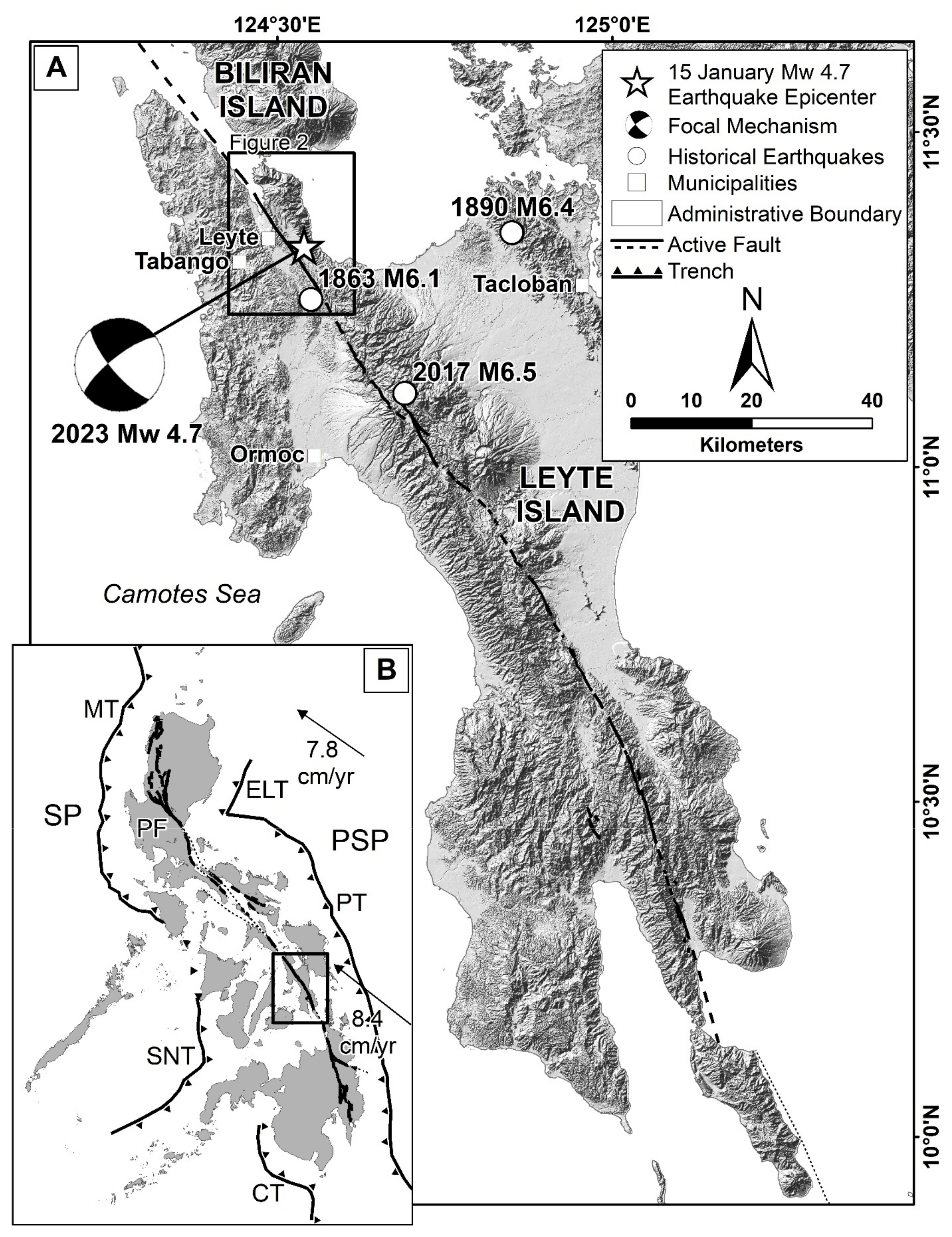
2. Tectonic Setting
3. Methodology
4. Earthquake Parameters, Focal Mechanism, and Aftershocks
5. Geologic Impacts
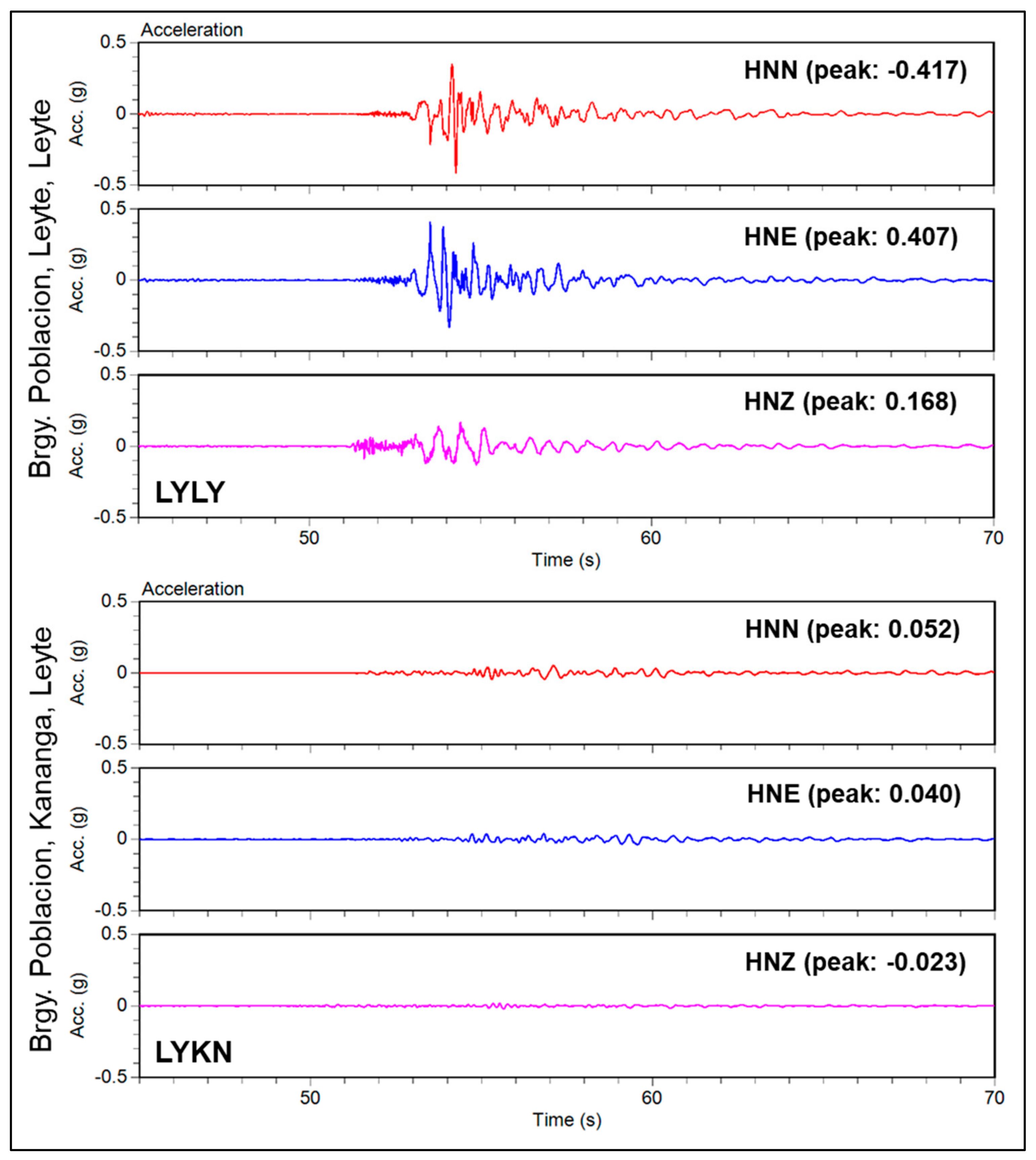
5.1. Ground Shaking and Intensity Distribution
5.2. Surface Rupture
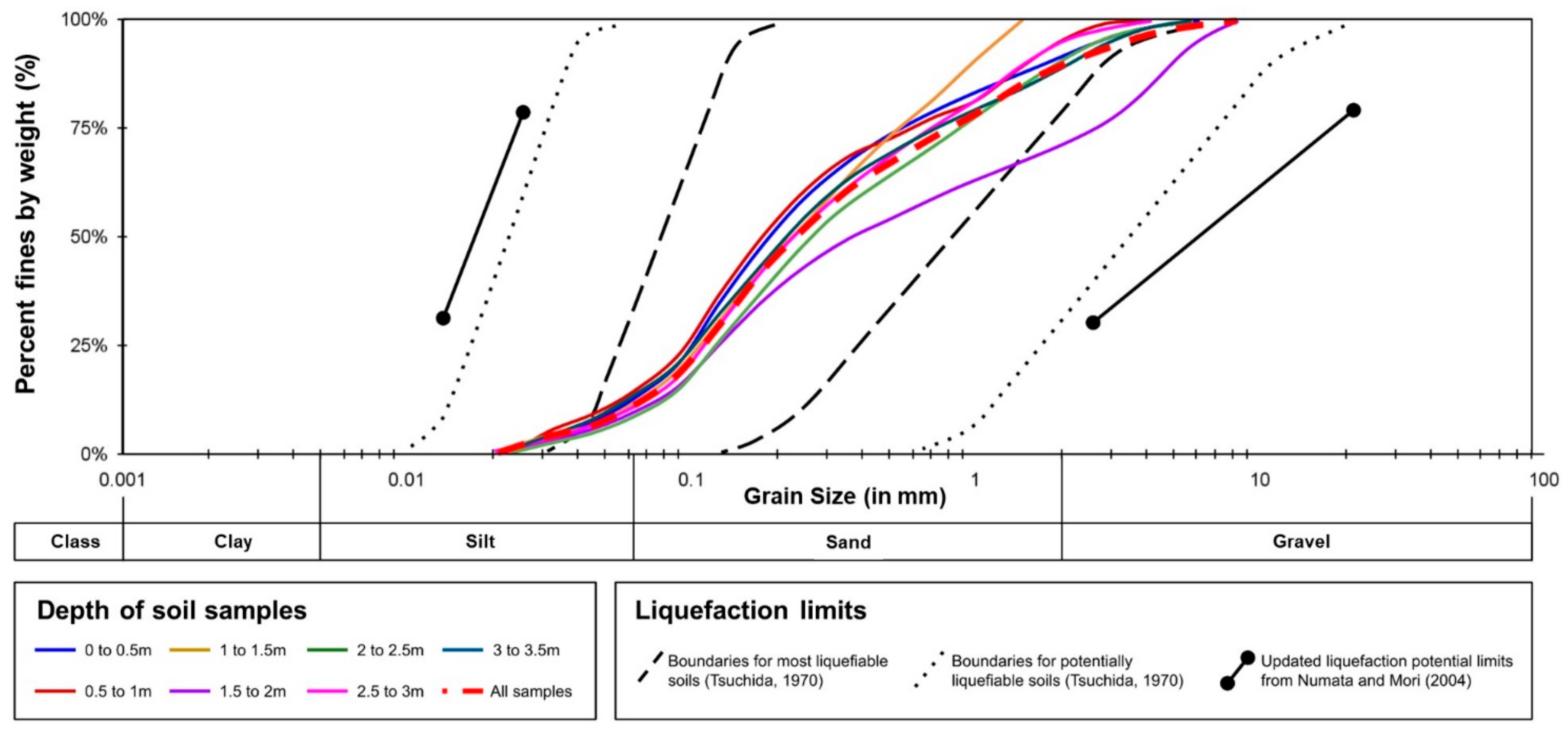
5.3. Liquefaction
5.4. Landslide
6. Structural and Socio-Economic Impacts
7. Discussion
8. Summary and Conclusions
Author Contributions
Funding
Data Availability Statement
Acknowledgments
Conflicts of Interest
References
- Aurelio, M.A.; Dianala, J.D.B.; Taguibao, K.J.L.; Pastoriza, L.R.; Reyes, K.; Sarande, R.; Lucero, A., Jr. Seismotectonics of the 06 February 2012 Mw 6.7 Negros Earthquake. J. Asian Earth Sci. 2017, 142, 93–108. [Google Scholar] [CrossRef]
- Lagmay, A.M.F.; Eco, R. Brief communication: On the source characteristics and impacts of the magnitude 7.2 Bohol earthquake. Nat. Hazards Earth Syst. Sci. 2014, 14, 2795–2801. [Google Scholar] [CrossRef]
- DOST-PHIVOLCS Quick Response Team. 10 February 2017 Ms 6.7 Surigao del Norte Earthquake. PHIVOLCS Special Report. 2018. Available online: https://www.phivolcs.dost.gov.ph/index.php/publications/special-report (accessed on 15 December 2023).
- DOST-PHIVOLCS Quick Response Team. 06 July 2017 Ms 6.5 Leyte Earthquake. PHIVOLCS Special Report. 2018. Available online: https://www.phivolcs.dost.gov.ph/index.php/publications/special-report (accessed on 15 December 2023).
- DOST-PHIVOLCS Quick Response Team. 22 April 2019 Magnitude 6.1 Central Luzon Earthquake. PHIVOLCS Special Report. 2020. Available online: https://www.phivolcs.dost.gov.ph/index.php/publications/special-report (accessed on 15 December 2023).
- PHIVOLCS. The 2019 Series of Earthquakes in Cotabato and Its Vicinity. Destructive Earthquakes in the Philippines. 2019. Available online: https://phivolcs.dost.gov.ph/index.php/earthquake/destructive-earthquake-of-the-philippines (accessed on 15 December 2023).
- PHIVOLCS. The 2020 Magnitude 6.6 Masbate Earthquake. Destructive Earthquakes in the Philippines. 2020. Available online: https://phivolcs.dost.gov.ph/index.php/earthquake/destructive-earthquake-of-the-philippines (accessed on 15 December 2023).
- Perez, J.S.; Llamas, D.C.E.; Dizon, M.P.; Buhay, D.J.L.; Legaspi, C.J.M.; Lagunsad, K.D.B.; Constantino, R.C.C.; De Leon, R.J.B.; Quimson, M.M.Y.; Grutas, R.N.; et al. Impacts and causative fault of the 2022 magnitude (Mw) 7.0 Northwestern Luzon earthquake, Philippines. Front. Earth Sci. 2023, 11, 1091595. [Google Scholar] [CrossRef]
- National Disaster Risk Reduction and Management Council (NDRRMC). Progress Report No. 3 for Magnitude 5.3 Earthquake in Leyte, Leyte (Region VIII) 2023. Available online: https://monitoring-dashboard.ndrrmc.gov.ph/exports/export/incidents/2899 (accessed on 15 December 2022).
- Tsutsumi, H.; Perez, J.S. Large-scale digital mapping of the Philippine fault zone based on aerial photograph interpretation. Act. Faults Res. 2013, 39, 29–37. [Google Scholar] [CrossRef]
- Bautista, M.L.P.; Oike, K. Estimation of the magnitudes and epicenters of Philippine historical earthquakes. Tectonophysics 2000, 317, 137–169. [Google Scholar] [CrossRef]
- PHIVOLCS. Earthquake Information. 2023. Available online: https://www.phivolcs.dost.gov.ph/2023_Earthquake_Information (accessed on 15 December 2023).
- Aurelio, M.A.; Peña, R.E. (Eds.) Geology of the Philippines, 2nd ed.; Mines and Geosciences Bureau, Department of Environment and Natural Resources: Quezon City, Philippines, 2010; 532p.
- Aurelio, M.A. Shear partitioning in the Philippines: Constraints from Philippine fault and global positioning system data. Island Arc 2000, 9, 584–597. [Google Scholar] [CrossRef]
- Fitch, T.J. Plate convergence, transcurrent faults, and internal deformation adjacent to Southeast Asia and the western Pacific. J. Geophys. Res. 1972, 77, 4432–4460. [Google Scholar] [CrossRef]
- Perez, J.S.; Cahulogan, M.T.; Abigania, M.I.T.; Daag, A.S.; Montes, A.G.; Canete, N.M.; Tsutsumi, H.; Solidum, R.S. The Philippine fault zone-Leyte segment: Site of catastrophic landslide and creeping movements. In Proceedings of the Abstracts of the 7th General Assembly of the Asian Seismological Commission and 2008 Seismological Society of Japan Fall Meeting 2008, Tsukuba, Japan, 24–27 November 2008; p. X4-084. [Google Scholar]
- Tsutsumi, H.; Perez, J.S.; Lienkaemper, J.J. Variation of Surface Creep Rate along the Philippine Fault Based on Surveys of Alignment Arrays and Offset Cultural Features. In AGU Fall Meeting Abstracts; American Geophysical Union: Washington, DC, USA, 2016; Available online: https://ui.adsabs.harvard.edu/abs/2016AGUFM.T23A2907T/abstract (accessed on 15 December 2023).
- Fukushima, Y.; Hashimoto, M.; Miyazawa, M.; Uchida, N.; Taira, T. Surface creep rate distribution along the Philippine fault, Leyte Island, and possible repeating of Mw ~ 6.5 earthquakes on an isolated locked patch. Earth Planets Space 2019, 71, 118. [Google Scholar] [CrossRef]
- Dianala, J.D.B.; Jolivet, R.; Thomas, M.Y.; Fukushima, Y.; Parsons, B.; Walker, R. The Relationship Between Seismic and Aseismic Slip on the Philippine Fault on Leyte Island: Bayesian Modeling of Fault Slip and Geothermal Subsidence. J. Geophys. Res. Solid Earth 2020, 125, e2020JB020052. [Google Scholar] [CrossRef]
- Nakano, M.; Kumagai, H.; Inoue, H. Waveform inversion in the frequency domain for the simultaneous determination of earthquake source mechanism and moment function. Geophys. J. Int. 2008, 173, 1000–1011. [Google Scholar] [CrossRef]
- Bonita, J.D.; Kumagai, H.; Nakano, M. Regional moment tensor analysis in the Philippines: CMT solutions in 2012–2013. J. Disaster Res. 2015, 10, 18–24. [Google Scholar] [CrossRef]
- Punongbayan, B.J.T.; Kumagai, H.; Pulido, N.; Bonita, J.D.; Nakano, M.; Yamashina, T.; Maeda, Y.; Inoue, H.; Melosantos, A.A.; Figueroa, M.F.; et al. Development and operation of a regional moment tensor analysis system in the Philippines: Contributions to the understanding of recent damaging earthquakes. J. Disaster Res. 2015, 10, 25–34. [Google Scholar] [CrossRef]
- Lasala, M.; Inoue, H.; Tiglao, R.; Fan, Z.; Bautista, B.; Narag, I. Establishment of earthquake intensity meter network in the Philippines. J. Disaster Res. 2015, 10, 43–50. [Google Scholar] [CrossRef]
- Bonilla, M.G. Minimum earthquake associated with coseismic surface faulting. Environ. Eng. Geosci. 1988, 25, 17–29. [Google Scholar] [CrossRef]
- Wells, D.L.; Coppersmith, K.J. New empirical relationships among magnitudes, rupture length, rupture width, rupture area, and surface displacement. Bull. Seis. Soc. Am. 1994, 84, 974–1002. [Google Scholar] [CrossRef]
- Llamas, D.C.E.; Llamas, D.C.E.; Perez, J.S.; Constantino, R.C.C.; Buhay, D.J.L.; Legaspi, C.J.M. Surface rupture along the Leyte creeping segment of the Philippine Fault: The 2023 Mw 4.7 Leyte, Leyte earthquake. 2023; in preparation. [Google Scholar]
- Tsuchida, H. Prediction and countermeasure against the liquefaction in sand deposits. In Proceedings of the Abstract of the Seminar in the Port and Harbor Research Institute; Ministry of Transport: Yokosuka, Japan, 1970; pp. 31–333. [Google Scholar]
- Numata, A.; Mori, S. Limits in the gradation curves of liquefiable soils. In Proceedings of the 13th World Conference on Earthquake Engineering, Vancouver, BC, Canada, 1–6 August 2004; p. 1190. [Google Scholar]
- Castilla, R.A.; Audemard, F.A. Sand blows as a potential tool for magnitude estimation of pre-instrumental earthquakes. J. Seismol. 2007, 11, 473–487. [Google Scholar] [CrossRef]
- Papadopoulos, G.A.; Plessa, A. Magnitude-distance relations for the earthquake-induced landslides in Greece. Eng. Geol. 2000, 58, 377–386. [Google Scholar] [CrossRef]
- Department of Science and Technology—Philippine Institute of Volcanology and Seismology (DOST-PHIVOLCS). Liquefaction Hazard Map of Leyte Province; Department of Science and Technology—Philippine Institute of Volcanology and Seismology (DOST-PHIVOLCS): Quezon City, Philippines, 2009. Available online: https://www.phivolcs.dost.gov.ph/index.php/gisweb-hazard-maps (accessed on 15 December 2022).
- Department of Science and Technology—Philippine Institute of Volcanology and Seismology (DOST-PHIVOLCS). Earthquake-Induced Landslide Hazard Map of Leyte Province; Department of Science and Technology—Philippine Institute of Volcanology and Seismology (DOST-PHIVOLCS): Quezon City, Philippines, 2009. Available online: https://www.phivolcs.dost.gov.ph/index.php/gisweb-hazard-maps (accessed on 15 December 2022).
- Association of Structural Engineers of the Philippines. National Structural Code of the Philippines, 7th ed.; Association of Structural Engineers of the Philippines: Quezon City, Philippines, 2015. [Google Scholar]


| Earthquake Intensity | Province | City/Municipality |
|---|---|---|
| VI (very strong) | Leyte | Along the strike of the Philippine Fault—Leyte segment in Leyte and the easternmost part of Tabango |
| V (strong) | Leyte | The rest of Tabango and Leyte; Capoocan and Kananga |
| IV (moderately strong) | Leyte | Calubian, Carigara, and San Isidro |
| III (weak) | Biliran | Biliran, Cabucgayan, Caibiran, Culaba, and Naval |
| Leyte | Alangalang, Babatngon, Barugo, Jaro, San Miguel, Tunga, Villaba, Ormoc City, and City of Tacloban | |
| II (slightly felt) | Biliran | Almeria |
| Leyte | Albuera, Matag-ob, Santa Fe, Pastrana, Merida, Palompon, Palo, and Isabel | |
| I (scarcely perceptible) | Cebu | City of Bogo |
| Eastern Samar | City of Borongan |
Disclaimer/Publisher’s Note: The statements, opinions and data contained in all publications are solely those of the individual author(s) and contributor(s) and not of MDPI and/or the editor(s). MDPI and/or the editor(s) disclaim responsibility for any injury to people or property resulting from any ideas, methods, instructions or products referred to in the content. |
© 2024 by the authors. Licensee MDPI, Basel, Switzerland. This article is an open access article distributed under the terms and conditions of the Creative Commons Attribution (CC BY) license (https://creativecommons.org/licenses/by/4.0/).
Share and Cite
Perez, J.S.; Llamas, D.C.E.; Buhay, D.J.L.; Constantino, R.C.C.; Legaspi, C.J.M.; Lagunsad, K.D.B.; Grutas, R.N.; Quimson, M.M.Y. Impacts of a Moderate-Sized Earthquake: The 2023 Magnitude (Mw) 4.7 Leyte, Leyte Earthquake, Philippines. Geosciences 2024, 14, 61. https://doi.org/10.3390/geosciences14030061
Perez JS, Llamas DCE, Buhay DJL, Constantino RCC, Legaspi CJM, Lagunsad KDB, Grutas RN, Quimson MMY. Impacts of a Moderate-Sized Earthquake: The 2023 Magnitude (Mw) 4.7 Leyte, Leyte Earthquake, Philippines. Geosciences. 2024; 14(3):61. https://doi.org/10.3390/geosciences14030061
Chicago/Turabian StylePerez, Jeffrey S., Deo Carlo E. Llamas, Daniel Jose L. Buhay, Ryan Christian C. Constantino, Crystel Jade M. Legaspi, Kristine Dionne B. Lagunsad, Rhommel N. Grutas, and Marc Marion Y. Quimson. 2024. "Impacts of a Moderate-Sized Earthquake: The 2023 Magnitude (Mw) 4.7 Leyte, Leyte Earthquake, Philippines" Geosciences 14, no. 3: 61. https://doi.org/10.3390/geosciences14030061
APA StylePerez, J. S., Llamas, D. C. E., Buhay, D. J. L., Constantino, R. C. C., Legaspi, C. J. M., Lagunsad, K. D. B., Grutas, R. N., & Quimson, M. M. Y. (2024). Impacts of a Moderate-Sized Earthquake: The 2023 Magnitude (Mw) 4.7 Leyte, Leyte Earthquake, Philippines. Geosciences, 14(3), 61. https://doi.org/10.3390/geosciences14030061