


Abstract
This study presents the vegetation of a Mediterranean area in Croatia, abandoned by the military three decades ago after two centuries of use. From 2023 to 2025, 97 phytosociological relevés were taken using the Braun–Blanquet approach. Based on numerical classification, we identified seven plant associations, two subassociations, and two communities within nine floristically and ecologically distinct vegetation classes. Military presence shaped the landscape in several ways. Large parts of the peninsula remain near-natural, covered by high maquis with minimal disturbance. Plateau shooting ranges, formerly grasslands, now represent rare habitats due to ongoing succession. Within former barracks, plantings included low-maintenance species providing rapid greening and visual screening. Evergreen conifers were favored for year-round greenery, while deciduous trees and ornamental shrubs provided shade and aesthetic value. Given current neglect and ongoing successional trends, the site requires a carefully planned management program aimed at habitat restoration, control of shrub encroachment, and maintenance of open and semi-open vegetation to preserve biodiversity and landscape heterogeneity.
1. Introduction
While the flora of the Mediterranean zone of Croatia is relatively well-documented [1], the same cannot be asserted regarding the extent of understanding of their vegetation [2]. Although phytosociological research in Mediterranean Croatia began relatively early [3,4], many areas have remained understudied in terms of vegetation diversity, or at least have not been as thoroughly investigated as some other regions. Generally, the northern part of the Croatian coast, including its islands and islets, is better documented compared to the southern regions of the country [5].
Here, we fill gaps in the cenological knowledge of vegetation in the southernmost Croatian territory, which was under military influence for two centuries. Although it is difficult to reconstruct the exact types of military activities and the number of troops during that period, the literature data indicate that the impacts of military use are diverse and can affect the landscape and soil, potentially leading to deforestation, habitat destruction, and fragmentation (for review, see [6]). The ecological responses to military disturbance are complex and variable [7]. Thus, the same type of training may result in positive, neutral, or negative impacts depending on the habitat or taxa involved [8]. Paradoxically, military presence and training methods may contribute to the preservation of natural habitats, highlighting their potential importance for conservation research in such areas [9].
In this study, target area has been used as operational military training base, which was abandoned by the military 33 years ago, after two centuries of military use. Military installations include facilities used to accommodate personnel, store equipment, and support training activities and tactical operations. The development of such infrastructure can have varying environmental effects, depending on the characteristics of the surrounding landscape and ecosystems, making these impacts highly location-specific [10,11,12]. Despite this, military training areas often represent valuable opportunities for biodiversity conservation. However, there remains a notable shortage of scientific research focused on these environments, especially within Europe.
This study presents new phytosociological data, together with an ecological framework and a classification of vegetation types. The objectives were to: (i) deliver a comprehensive phytosociological characterization and syntaxonomic classification of plant communities in the southernmost mainland region of Croatia; (ii) evaluate their ecological importance within the wider pattern of vegetation diversity along the eastern Adriatic coast; and (iii) identify vegetation types or habitats most closely associated with past military presence, thereby supporting conservation efforts and informing ecological restoration where needed.
2. Materials and Methods
2.1. Study Area
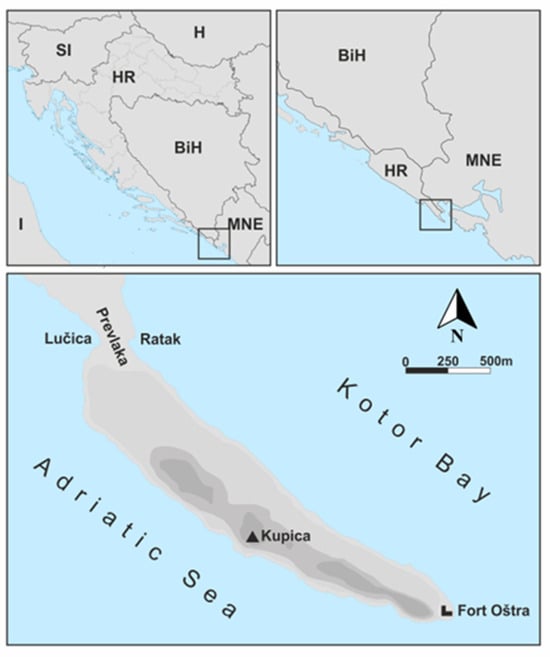
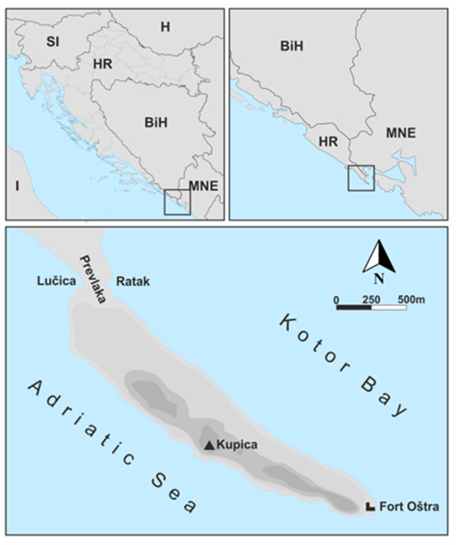
The Oštra Peninsula (0.933 km2, max. altitude 65 m) is 2.5 km long, widest in the middle (480 m), and narrowest (170 m) on the western part (Figure 1). The coasts are rocky; southern coast consists of steep coastal cliffs (up to 30 m high), while the northern one is mostly low. The underlying bedrock is formed by highly permeable Cretaceous limestones, while calcaric cambisol represents the prevailing soil type [13,14].
Figure 1.
The investigated Oštra Peninsula (0.933 km2) represents the southeasternmost mainland part of the Croatian territory, and closes the western part of the entrance to Bay of Kotor in the southeastern Adriatic Sea, NE Mediterranean. Boxes in the two upper panels indicate the study area in a wider geographical context. Country abbreviations: I (Italy), SI (Slovenia), H (Hungary), HR (Croatia), BiH (Bosnia and Herzegovina), MNE (Montenegro).
The climate is Mediterranean, with a mean annual air temperature of 16.4 °C [15]. The highest mean monthly temperature occurs in August (30.1 °C), while the lowest occurs in January (4.9 °C). Mean annual precipitation amounts to 1326 mm. The area receives approximately 2666 h of sunshine per year (data from the Dubrovnik meteorological station, DHMZ). SSE and NNE winds are the most frequent [5]. Mean annual relative humidity is 71%. According to the Köppen climate classification [16,17], the study area belongs to the Csa climate type, characterized as a temperate climate with dry, hot summers [18].
The area is phytogeographically characterized by meso-Mediterranean evergreen vegetation of the Fraxino orni–Quercion ilicis alliance, while the southern slopes support Oleo-Ceratonion siliquae communities [5].
2.2. Human Factor
Strategically located for controlling access to the Bay of Kotor, the peninsula has held considerable military importance throughout history. After the Republic of Dubrovnik expanded its rule to southern region (Konavle) in the early 15th century, the peninsula gained prominence as both a defensive outpost and a refuge for the local population during times of conflict [19]. During the Napoleonic Wars (1808–1813), the French were the first to establish military infrastructure on the peninsula. Under Austro-Hungarian rule in the mid-19th century, the Fort Oštra—still the most prominent structure on the peninsula—was constructed (Figure 1).
Civilians, mainly from the nearby village of Vitaljina, coexisted with the military, and the 1880 population census recorded permanent residents on the peninsula for the first time. However, this coexistence ended during World War I, when civilian access was restricted. In 1917, the army of the Kingdom of Serbs, Croats, and Slovenes prohibited the use of the land by Vitaljina villagers.
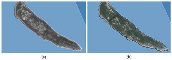
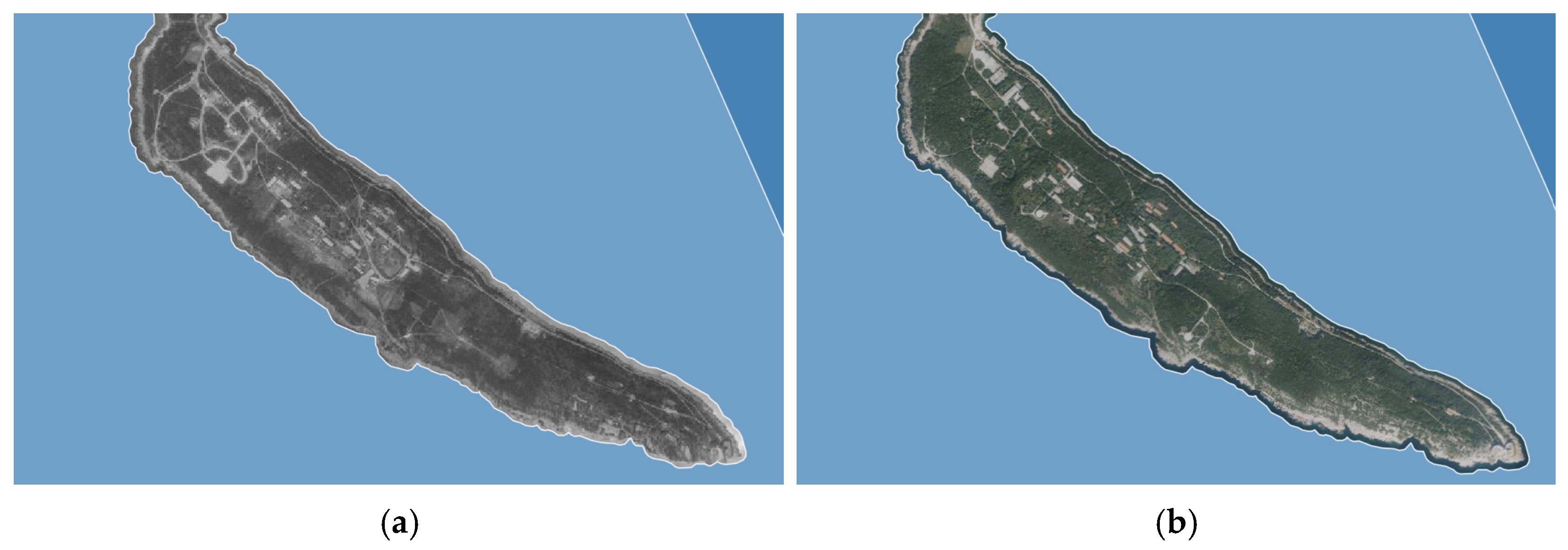
During World War II, the peninsula was successively occupied by Italian (1941–1943) and German (1943–1945) forces, who transformed it into a concentration camp, once again excluding civilians. In 1955, the Yugoslav Army took control of the peninsula, sealing it off from the public and expanding its military infrastructure. This included the construction of a port, numerous buildings (48 in total), a radar station, and a small-arms firing range, which remained operational until 1992 (Figure 2).
Figure 2.
Aerial view of the Oštra Peninsula during intensive military activity in 1968 provided by the State Geodetic Administration of the Republic of Croatia (a), and in 2024, 30 years after military abandonment (b), derived and adapted from Google Earth Pro, version 7.3. Mountain View, CA, USA: Google. Scale 1:10,000. The light-colored areas represent military infrastructure (helipad, red-roofed buildings, and roads), while green indicates vegetation cover.
Today, although the peninsula is uninhabited, it is a popular one-day tourist destination during the summer season. The nearest settlement is the village of Vitaljina, located 2 km from the peninsula, with 153 inhabitants according to the 2021 census. Residents of Vitaljina own land on the peninsula, including forests and olive groves. The olive groves are relatively young and are managed extensively. Among grazing animals, a large herd of goats roams the peninsula year-round, although the exact number of individuals is unknown.
2.3. Data Collection and Analyses
Field data were collected from 97 vegetation plots (phytosociological relevés) between November 2023 and June 2025, covering the entire area of the Oštra Peninsula and neighboring sea. The geographical coordinates of the relevés are provided in Table S1. Vegetation was studied according to the principles of the Braun–Blanquet approach [20,21], adopting the International Code of Phytosociological Nomenclature [22]. Plot sizes varied depending on vegetation type. For maquis, they ranged from 10 to 200 m2 (mean 136 m2), while garrigue plots covered 16–25 m2 (mean 21.5 m2), and grassland plots covered 10–25 m2 (mean 21.3 m2). Relevés of rocky and wall vegetation were conducted on smaller plots of 6–10 m2 (mean 8 m2), whereas nitrophilous vegetation was sampled on plots of 10–25 m2 (mean 16.9 m2). Similarly, rocky coastal vegetation was recorded using plots ranging from 10 to 25 m2 (mean 16 m2). Overall, these plot dimensions are largely consistent with previously recommended sizes for the respective vegetation types [23].
The nomenclature of higher-rank vegetation units follows the syntaxonomical system (EuroVegChecklist, EVC) proposed by Mucina et al. [24] and adopted by Škvorc et al. [25], with particular emphasis on the sequence of vegetation classes and their subordinate syntaxa as defined within this framework. Diagnostic species of phytosociological classes were determined using Mucina et al. [24] and an online database of European vegetation, habitats and flora [26,27]. The nomenclature of vascular plant taxa follows Plants of the World Online [28].
To gain insight into the diversity of bryophytes on the peninsula, we conducted a one-time bryophyte inventory, the first ever carried out on the peninsula. The nomenclature of bryophytes follows that outlined by Hodgetts et al. [29].
EUNIS habitat types were assigned following the framework proposed by Chytrý et al. [30], in combination with information obtained from an online database of European vegetation, habitats, and flora [27]. Marine habitat categories were defined according to the 2022 version of the EUNIS marine habitat classification, as provided by the EEA [31]. The correspondence between identified vegetation units (alliances) and habitat types listed in Annex I of the Habitats Directive (92/43/EEC) was established based on the official Croatian national list of NATURA 2000 habitat types [32].
Numerical techniques were employed to classify vegetation patterns, and the results were evaluated in relation to the conventional syntaxonomic framework. The dataset included 334 taxa recorded in 97 relevés. Cover-abundance estimates originally assigned according to the Braun–Blanquet scale [20] were recoded into a 1–9 ordinal scale prior to analysis [21]. Vegetation types were identified using agglomerative hierarchical clustering based on Bray–Curtis dissimilarity, with Ward’s linkage method used to define cluster structure [33]. To minimise the influence of overall cover on similarity relationships, the data were subjected to both power (y′ = y^w) and logarithmic [y′ = log (y + 1)] transformations before clustering. Statistical differences among the identified groups were assessed using analysis of similarities (ANOSIM). All computations were carried out in PC-ORD (version 5, Gleneden Beach, Oregon) and PRIMER (version 7, Plymouth, UK) [33,34].
3. Results
From a total of 97 vegetation relevés (rels.) collected on the Oštra Peninsula and in the adjacent coastal area, 44 were recorded in maquis vegetation, 4 in garrigue, 12 in grasslands, 3 in marine vegetation, 16 in halophilous communities on bare or very shallow soils, 6 in rocky cliffs, crevices and walls, and 12 in ruderal vegetation.
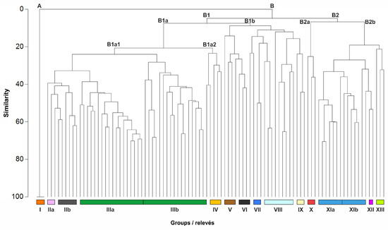
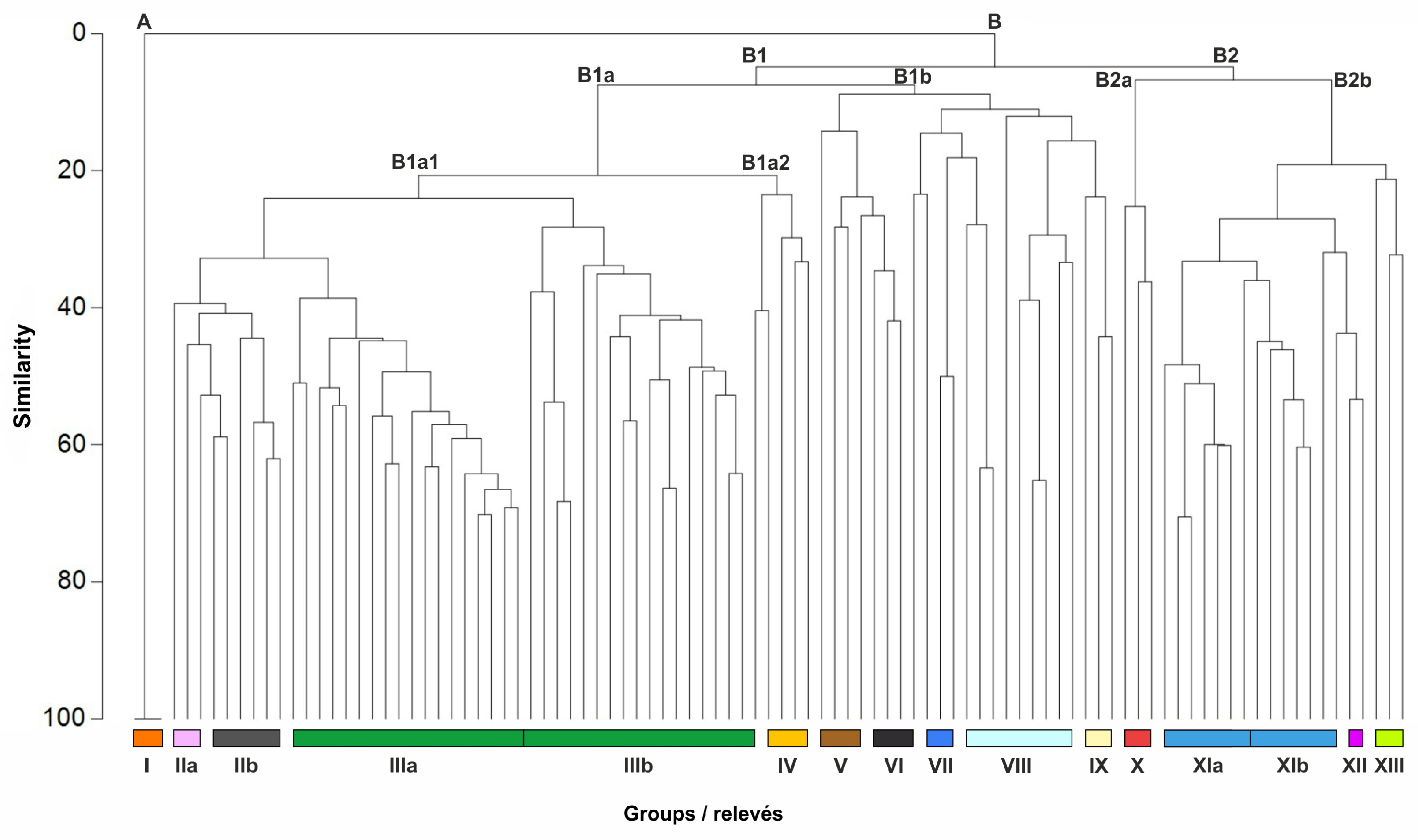
The dendrogram obtained from the hierarchical clustering analysis of the data matrix makes it possible to distinguish two main clusters (A, B) of associations (Figure 3). The first cluster (A) exclusively comprises perennial seagrass meadow vegetation (I). The second cluster (B) includes terrestrial vegetation and is divided into two subclusters (B1 and B2). Subcluster B1 mainly includes maquis of the Quercetea ilicis class (B1a1) and Artemisietea vulgaris (B1a2), and more open habitats, such as garrigue, grasslands and ruderal communities (B1b). ANOSIM analysis revealed significant differences between clusters A and B (R = 0.76, p = 0.001) and between subclusters B1 and B2 (R = 0.55, p = 0.001), using a cumulative contribution threshold of W = 0.5.
Figure 3.
Hierarchical cluster analysis dendrogram based on Bray–Curtis similarity distance and Ward’s minimum variance method of the data matrix of 334 taxa × 97 samples (relevés). Groups of relevés: I—Posidonietum oceanicae; IIa—Pistacio lentisci-Juniperetum turbinatae; IIb—Myrto communis-Pistacietum lentisci; IIIa,b—Myrto communis-Quercetum ilicis; IV—Arundinetum plinianae; V—Erico manipuliflorae-Cistetum cretici; VI—Hyparrhenia hirta community; VII—Cynodon dactylon community; VIII—group composed of only one or two relevés; IX—Hordeetum leporini; X—Seslerio robustae-Putorietum calabricae; XIa—Limonietum anfracti typicum; XIb—Limonietum anfracti seslerietosum robustae; XII—relevés of coastal shingle beach vegetation; XIII—relevés of vegetation on walls.
Subcluster B1a comprises several maquis groups: predominantly low maquis occurring on the southern slopes of the peninsula (groups IIa and IIb of relevés); high maquis covering the largest area of the peninsula (IIIa); and maquis on heavily disturbed former military sites, which markedly differs from the preceding group in physiognomy and floristic composition (IIIb). Low shrub stands dominated by Arundo plinii, also occurring in disturbed areas, are assigned to subcluster B1a2 (group IV).
Subcluster B1b (Figure 3) comprises four relevés of garrigue (group V), four relevés of grassland (group VI), and three relevés each of ruderal communities dominated by Cynodon dactylon (VII) and Hordeum murinum subsp. leporinum (IX). In addition, this subcluster comprises relevés of several open habitats that are poorly represented on the peninsula; some stands (communities) are documented by only one relevé (four in total) or two relevés (eight in total) (group VIII). In such cases, a formal syntaxonomic assignment based on one or two relevés was not attempted in this study. However, their floristic composition is provided in Supplementary Table S5 (relevés 15–16) and Table S8, and is briefly discussed below.
The last subcluster (B2) includes four groups of relevés collected (i) in vegetation of rocky cliffs largely not influenced by seawater wave action (group X); (ii) in the salt-spray zone along the rocky coastline (groups XIa and XIb); (iii) on coastal shingle beaches (XII); and (iv) on man-made walls (XIII).
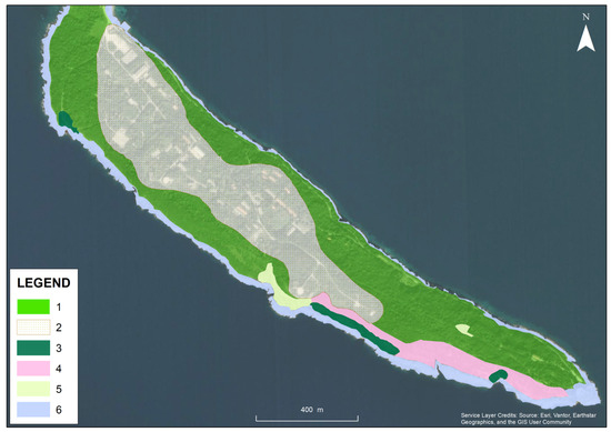
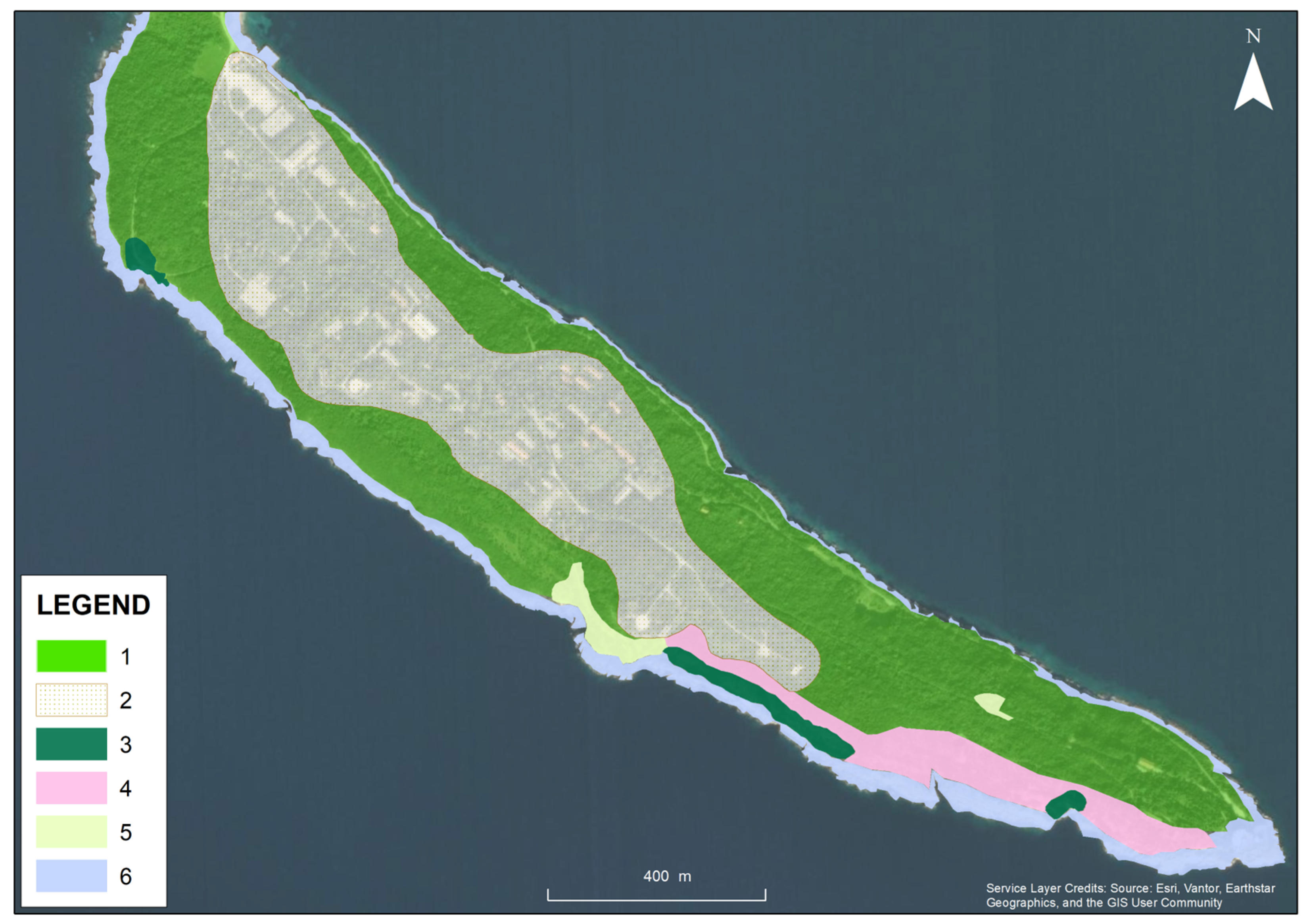
Based on the relevé data, a vegetation distribution map of the peninsula was constructed (Figure 4). The map indicates that the relevés assigned to groups IIIb and IV occur in the central part of the peninsula, corresponding to areas with the highest density of buildings and military infrastructure.
Figure 4.
Vegetation distribution map of the Oštra Peninsula (0.933 km2) based on a phytosociological survey conducted between 2023 and 2025; areas shown in different colours represent stands of woody, garrigue and coastal associations. The legend contains numbers indicating the area corresponding to each vegetation type or association: 1 = more or less impenetrable stands of Myrto communis–Quercetum ilicis; 2 = anthropogenically altered stands of Myrto communis-Quercetum ilicis around military facilities and infrastructure; 3 = Myrto communis-Pistacietum lentisci; 4 = Pistacio lentisci-Juniperetum turbinatae; 5 = garrigue stands of the Erico manipuliflorae-Cistetum cretici association; 6 = the salt-spray zone along the rocky coastline representing the habitat of the Limonietum anfracti association.
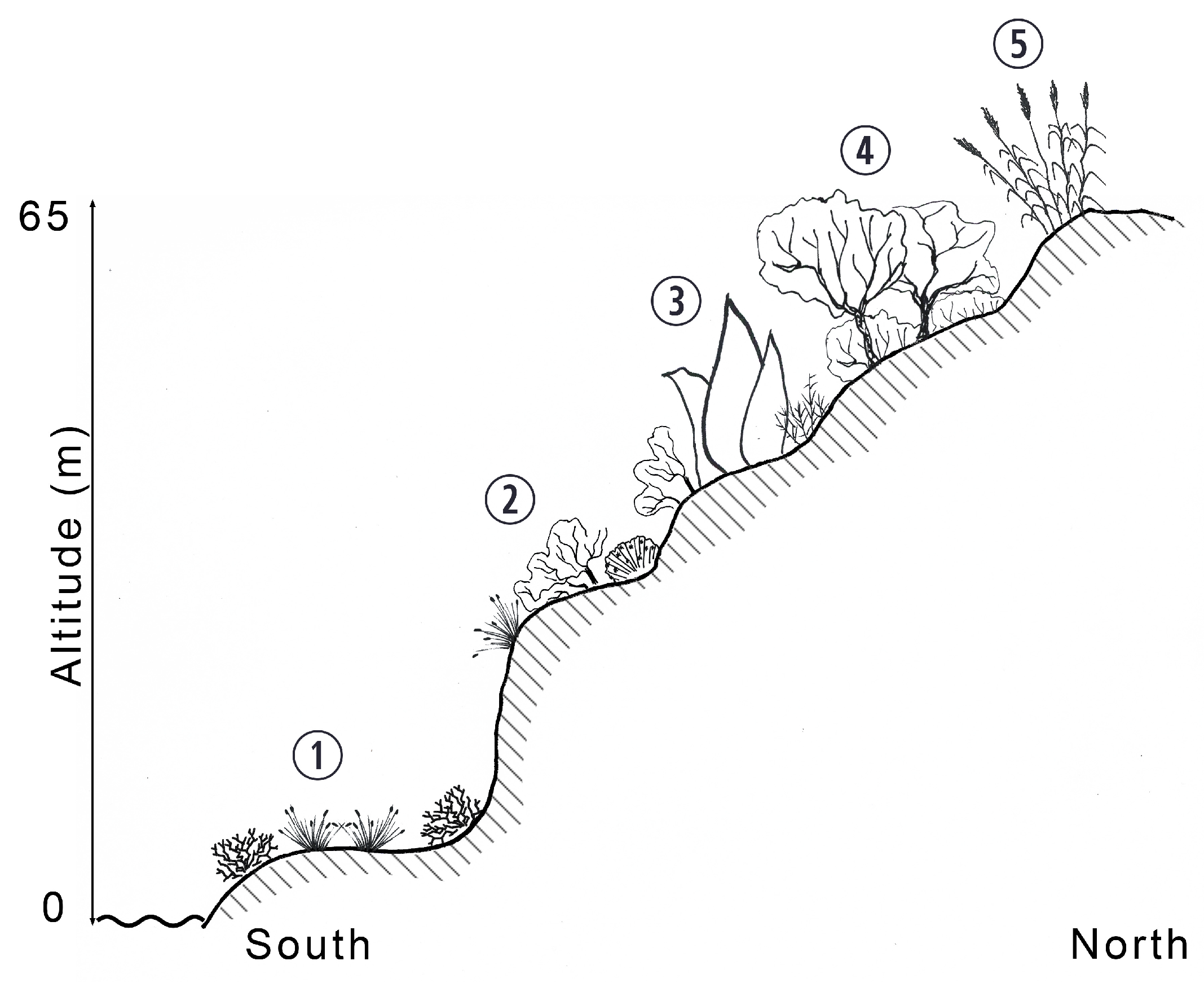
The vertical (altitudinal) distribution of vegetation from sea level to the highest elevation (0–65 m a.s.l.) of the peninsula, with particular reference to its southern part, is illustrated in Figure 5.
Figure 5.
Altitudinal distribution of the vegetation from sea level to the highest elevation (0–65 m a.s.l.) in the southern part of the peninsula. Legend: 1 = Limonietum anfracti seslerietosum robustae; 2 = Myrto communis-Pistacietum lentisci; 3 = Pistacio lentisci-Juniperetum turbinatae; 4 = Myrto communis-Quercetum ilicis; 5 = Arundinetum plinianae.
The results were interpreted from a syntaxonomic perspective, and the corresponding syntaxonomic scheme is presented below.
Syntaxonomic scheme
QUERCETEA ILICIS Br.-Bl. ex A. Bolós et O. de Bolòs in A. Bolòs y Vayreda 1950
Quercetalia ilicis Br.-Bl. ex Molinier 1934
Fraxino orni-Quercion ilicis Biondi, Casavecchia et Gigante in Biondi et al. 2013
Myrto communis-Quercetum ilicis (Horvatić 1963) Trinajstić (1976) 1985
Pistacio lentisci-Rhamnetalia alaterni Rivas-Mart. 1975
Oleo-Ceratonion siliquae Br.-Bl. ex Guinochet et Drouineau 1944
Pistacio lentisci-Juniperetum turbinatae Trinajstić 1987 ex Asensi, Díez-Garretas et Quézel 2007
Myrto communis-Pistacietum lentisci (Molinier 1954) Rivas-Mart. 1975
ONONIDO-ROSMARINETEA Br.-Bl. in A. Bolòs y Vayreda 1950
Cisto-Micromerietalia julianae Oberd. 1954
Cisto cretici-Ericion manipuliflorae Horvatić 1958
Erico manipuliflorae-Cistetum cretici Horvatić 1958
LYGEO SPARTI-STIPETEA TENACISSIMAE Rivas-Mart. 1978 nom. conserv. propos
Hyparrhenia hirta community
CRITHMO-STATICETEA Br.-Bl. in Br.-Bl. et al. 1952
Crithmo-Staticetalia Molinier 1934
Limonion anfracti-cancellati (Horvatić 1934) Mucina in Mucina et al. 2016
Limonietum anfracti Ilijanić et S. Hećimović 1982
helichrysetosum italici Jasprica 2015
seslerietosum robustae Jasprica, Dolina et Sabovljević, subass. nov. hoc loco
ASPLENIETEA TRICHOMANIS (Br.-Bl. in Meier et Br.-Bl. 1934) Oberd. 1977
Centaureo dalmaticae-Campanuletalia pyramidalis Trinajstić ex Terzi et Di Pietro 2016
Centaureo cuspidatae-Portenschlagiellion ramosissimae Trinajstić ex Terzi et Di Pietro 2016
Seslerio robustae-Putorietum calabricae Horvatić ex Birač 1973
CYMBALARIO-PARIETARIETEA DIFFUSAE Oberd. 1969
Tortulo-Cymbalarietalia Segal 1969
Galio valantiae-Parietarion judaicae Rivas-Mart. ex de Bolos 1967
ZOSTERETEA Pignatti 1953
Posidonietalia oceanicae Den Hartog ex Mucina in Mucina et al. 2016
Posidonion oceanicae Br.-Bl. ex Molinier 1960
Posidonietum oceanicae (Funk 1927) Molinier 1958
POLYGONO-POETEA ANNUAE Rivas-Mart. 1975
Cynodon dactylon community
CHENOPODIETEA Br.-Bl. in Br.-Bl. et al. 1952
Brometalia rubenti-tectorum (Rivas Goday et Rivas-Mart. 1973) Rivas-Mart. et Izco 1977 nom. conserv. propos.
Hordeion murini Br.-Bl. in Br.-Bl. et al. 1936
Hordeetum leporini Br.-Bl. 1936
ARTEMISIETEA VULGARIS Lohmeyer et al. in Tx. ex von Rochow 1951
Elytrigio repentis-Dittrichietalia viscosae Mucina 2016
Inulo viscosae-Agropyrion repentis Biondi et Allegrezza 1996
Arundinetum plinianae Biondi, Brugiapaglia, Allegrezza et Ballelli 1992
Seven vegetation alliances (Fraxino orni-Quercion ilicis, Oleo-Ceratonion siliquae, Cisto cretici-Ericion manipuliflorae, Limonion anfracti-cancellati, Centaureo cuspidatae-Portenschlagiellion ramosissimae, Galio valantiae-Parietarion judaicae and Posidonion oceanicae) recorded in the study area correspond to several EUNIS habitat types, including Mediterranean evergreen Quercus forests, maquis and garrigue vegetation, Mediterranean rocky sea cliffs and inland cliffs, and Posidonia oceanica beds, some of which also match habitat types listed in Annex I of the Habitats Directive (92/43/EEC) [30,31,32].
4. Discussion
4.1. Maquis
Based on the results, the following associations and plant communities have been recognized:
Among the holm-oak woody vegetation along the eastern Adriatic, the Myrto communis-Quercetum ilicis association occurs in warmer and drier areas [35]. It occupies the largest part of the peninsula (0.79 km2), representing 85% of its woody area.
Two stand types were distinguished based on physiognomy and floristic composition. Group IIIa (Table S2: relevés 1–23) consists of tall (2–8 m, mean 5 m), dense, and nearly impenetrable maquis, with a typical floristic composition of the eastern Adriatic coast [5]. Group IIIb (Table S2: relevés 24–35) comprises lower maquis (2–7 m, mean 4 m) with a pronounced abundance of non-native species, including Ligustrum lucidum, Ailanthus altissima, Cupressus sempervirens, Prunus cerasifera, and Pinus pinaster. These stands also include transgressive or ingressive species from the Lygeo sparti-Stipetea tenacissimae and Artemisietea vulgaris classes.
Group IIIb shows the strongest anthropogenic impact, mainly from military activities. Historical records suggest that plantings depended on personnel preferences rather than systematic schemes [36]. Former open areas, such as shooting grounds, now support stands dominated by Hyparrhenia hirta or Arundo plinii, along with maquis elements (Calicotome infesta). By contrast, the southern peninsula margin facing the sea has remained largely unchanged, as preserving natural vegetation was essential for camouflaging defensive structures.
Mediterranean maquis are generally characterized by lower species richness, primarily due to extremely limited light availability, particularly in the ground layer, as well as the physiological constraints of evergreen woody species under low winter air temperatures [37,38]. In parts of the peninsula that were not subjected to prolonged anthropogenic disturbance—largely due to the concealment of military installations—the maquis of the Myrto communis-Quercetum ilicis association exhibits a more natural structure, characterised by higher frequency and cover of character species (e.g., Quercus ilex, Myrtus communis, Pistacia lentiscus, Juniperus turbinata) and lianas (Smilax aspera, Rubia peregrina, Lonicera implexa). In contrast, areas affected by military activities show a decline in native woody species, accompanied by an increase in ruderal and open-habitat species. However, plant species richness did not differ between these two “variants” of the association (mean 20 taxa). In contrast, both showed significantly lower values compared to sites without human disturbance on islands in the central and southeastern Adriatic (25–50 taxa; mean 33.7) [39]. It is important to note that two other common drivers of human impact in Mediterranean maquis ecosystems—overgrazing and wildfires—have not been recorded in the study area over the past several decades.
This xerothermic mainly low and often impassable maquis, known from islands along the Adriatic coast and also reported from Naxos in the Aegean Sea (Cyclades), develops through natural succession of forest vegetation under very dry and warm conditions, and may also arise following the abandonment of agricultural land, such as vineyards [39]. In Croatia, Juniperus turbinata predominantly colonises islands and islets, irrespective of site exposure. In the present study, this community mainly occurs on the southern slopes of the peninsula, with a vegetation cover of 90–100%. It is characterised by the dominance of a limited number of species, with 11–25 taxa per relevé (mean 16). Species richness is comparable to that reported for the island of Unije in the northern Adriatic (10–15 taxa; mean 12.3), but considerably lower than values recorded along the coast and on islands in the southern Adriatic (15–30 taxa; mean 22.8) [40,41].
However, the literature data [39,40,41] indicate that the development of this association may follow different successional pathways, either towards forest communities such as Querco ilicis–Pinetum halepensis or along an alternative successional trajectory leading to Fraxino orni–Quercetum ilicis. The course of these processes largely depends on the geographic position of the stands and the associated climatic conditions of the area.
This plant community, consisting of dense shrubs 1–2 m in height, is distributed along Mediterranean coastlines from the western Mediterranean (Spain) to Croatia. In Croatia, it is typically restricted to the hottest and driest habitats, mainly on south-facing slopes of islands and islets, where it is strongly influenced by marine aerosols [39]. In the study area, it occurs along the exposed southern coastline of the peninsula, beyond the halophytic belt, and was not subject to military disturbance. Characteristic species of the class Crithmo-Staticetea, including Sesleria robusta, contribute to the floristic composition. Species richness is relatively low (10–15 taxa; mean = 11.5), which is consistent with previous findings from the eastern Adriatic [42].
4.2. Garrigue
This low-growing secondary evergreen shrublands (garrigue) are a secondary stage on cleared holm-oak forests [43]. In general, the garrigue is discontinuous and occurs on a drier soil than maquis [37]. In Croatia, the floristic composition of garrigue is highly variable, depending on geographical–climatic factors and altitudinal gradients [44]. However, it is primarily determined by the intensity of direct and indirect human impacts, as well as by the degree of soil degradation at specific sites.
Stands of the Erico manipuliflorae–Cistetum cretici association represent the most common type of garrigue in the central and southern eastern Adriatic. In the Middle Adriatic, the number of taxa per relevé varies considerably, ranging from 31–50 [41] to 15–23 on Brač [45] and 10–32 on Olib (mean 19.6) to 23–27 on Zlarin (mean 25) [46,47]. In the present study, although based on only four relevés, garrigue exhibited approximately twice the species richness (19–75 taxa; mean 48), likely due to the presence of species from open habitats (Festuco–Brometea and Stipo–Trachynietea distachyae) and ruderal vegetation (Chenopodietea). Trinajstić [45] related species richness to grazing intensity.
4.3. Dry Grassland
This perennial grassland mainly occurs on former pastures [48,49] and shows higher species richness (mean 37 taxa) than the Brachypodio retusi–Cymbopogonetum hirti Horvatić 1961 association, a similar community previously reported from Croatia (mean 17.6 taxa) [50]. Ruderal species from Chenopodietea and Artemisietea vulgaris are frequent. Following grazing abandonment, evergreen shrubs colonize these stands. Without formal management, succession towards forest vegetation is expected.
Our results (Figure 2a and Figure 4) show that the establishment of military training areas leads to a transition from open habitats (grasslands and ruderal vegetation) toward increased woody vegetation in currently abandoned areas. Caudal and Gallet [6] emphasize that the level of disturbance is determined by the intensity rather than the type of training. The decline of grassland areas should be considered in a broader context, as these habitats are essential for overall biodiversity (e.g., birds, butterflies). Based on the present vegetation patterns, the disturbance level corresponds to category II sensu Zentelis et al. [9], i.e., areas with medium military impact, where major landscape elements persist in reduced form, the impact of training remains evident, boundaries are indistinct, and topography is unchanged.
4.4. Low Rocky Coastal Vegetation
Rocky coasts host the low-spreading endemic shrub (Limonium dictyophorum) [51]. On the peninsula, stands of this association exhibit low species richness (4–19 taxa per relevé; mean 9), which is very similar to the diversity reported on small islands in the southern Adriatic (5–18 taxa) [52,53].
In this study, three belts are distinguished by distance from the sea (Figure 5), with Sesleria robusta dominant in the outermost belt. This species defines the new subassociation seslerietum robustae [54,55,56] (see Appendix A.1. for holotypus).
4.5. Cliff and Dry-Wall Chasmophytic Vegetation (Table S6, Figure 3: X, XIII)
Calcareous rocky slopes (Asplenietea trichomanis) and walls (Cymbalario–Parietarietea diffusae) are scarce habitats on the peninsula. Although walls generally show characteristics similar to rocky surfaces in natural environments, species richness is higher on walls (mean 22 taxa) than on rocky vegetation (mean 13), with 13 species shared between them. Rocky vegetation is dominated by Sesleria robusta and Putoria calabrica, corresponding to the Seslerio robustae–Putorietum calabricae association [55].
Wall communities contain a greater proportion of species from Chenopodietea, Crithmo-Staticetea, and Stipo–Trachynietea distachyae. Taxa such as Phillyrea latifolia and Pistacia lentiscus indicate a relationship with the Quercetea ilicis [57].
4.6. Posidonia Meadows
- Posidonietum oceanicae (Figure 3: group I)
Seagrass meadows occur at 1.5–15 m depth, providing key ecosystem services. Main pressures are anchoring and maritime traffic [58,59].
4.7. Ruderal Communities (Table S7, Figure 3: VII, IX)
Stands of the Cynodon dactylon community occupy dry soils near salt-spray vegetation or annual halophyte habitats (mean 15 taxa) [60,61]. Hordeetum leporini occurs along paths and roadsides near former military sites, dominated by Hordeum murinum subsp. leporinum and annuals from Chenopodietea and Artemisietea vulgaris [62].
In the eastern Adriatic Basin, Arundo plinii-dominated stands appears along the coastal belt from southern Croatia southwards to central Albania mainly on habitats exposed to disturbances [63]. In our study, this dense shrub formation develops in heavily disturbed areas, i.e., areas formerly subjected to intensive military activities (see Figure 5). In this study, the number of species per relevé ranged from 12 to 25 (mean 17), which corresponds to the species richness reported for other eastern Adriatic stands [63]. However, this association can occur in different vegetation types: one predominantly herbaceous (Inulo viscosae–Agropyrion repentis), although occasionally including shrubs, and another characterized by sclerophyllous shrub vegetation (Quercetea ilicis), which is richer in woody species, as observed in our case. Accordingly, this association may be interpreted as an ecotone between herbaceous and shrub vegetation [63,64,65].
4.8. Other Stands
Open and semi-open habitats are very limited on the peninsula, so some vegetation types are represented by only one or two relevés (Tables S5 and S8; Figure 3: groups VIII, XII). Single-relevé stands are dominated by Bromus erectus, Festuca myuros, Asphodelus fistulosus, and Scandix pecten-veneris with Tordylium apulum. Two-relevé stands comprise Narcissus tazetta with Asphodelus ramosus, Dactylis glomerata subsp. hispanica with Elymus repens, and Oloptum miliaceum. Coastal shingle vegetation is dominated by halophytes Crithmum maritimum and Limbarda crithmoides and lacks characteristic species of the eastern Adriatic association Euphorbio-Glaucietum flavi Horvatić 1934.
Although spatially limited, these stands contribute disproportionately to the peninsula’s plant biodiversity. They enhance habitat heterogeneity and local floristic diversity, highlighting their conservation importance in a landscape strongly influenced by past and present human activities.
Photos of all stands found on the peninsula are shown in Figure S1.
4.9. Remarks on the Vascular Flora and Bryophytes
Of 334 taxa recorded, 15 are on the Croatian Red List [1], (see Appendix A.2.). Ten taxa are endemic (Appendix A.3.), mostly Illyrian–Adriatic. Orchid species reported by Studniczka [66] in the peninsula’s maquis (e.g., Serapias, Ophrys) remain present. A notable share of the area is occupied by Ailanthus altissima and Opuntia ficus-indica within the maquis, as well as by invasive species in open, mainly ruderal, habitats (e.g., Erigeron spp., Sorghum halepense, Xanthium strumarium).
Bryophytes (47 species, Table S9) show a strong Mediterranean character. Rare species include Tortella commutata, Syntrichia calcicola, Tortula brevissima, and Trichostomum meridionale [67,68]. Liverworts were not surveyed but should be documented in future studies.
Bryophytes, among the earliest land plants, are an important functional component of vegetation, but their distribution is primarily driven by microhabitat conditions rather than vascular plant communities [69]. As they usually contribute little to total biomass, they are often omitted from general vegetation studies; therefore, following Marstaller [70], they are presented here as a species list rather than included in relevés.
Due to their high sensitivity to environmental change, bryophytes reflect climatic conditions and habitat heterogeneity, and can indicate ecosystem integrity [71,72,73]. In Mediterranean forests, they serve as indicators of long-term vegetation continuity, although they are less studied than in central and northern Europe [74].
We expect bryophyte diversity in the study area to increase with ongoing vegetation development and conservation, which will enhance microhabitat availability and stability.
5. Conclusions
This study investigates the vegetation of an area abandoned by the military three decades ago after nearly two centuries of occupation, addressing gaps in phytosociological knowledge of the southernmost mainland region of Croatia. Due to the small size of the study area, geological substrate and climatic conditions are largely uniform; therefore, vegetation diversity and species richness are mainly driven by slope exposure and distance from the sea, with human impact representing the dominant source of heterogeneity.
The analysis of vegetation types revealed a mosaic of successional stages shaped by both progressive and degradative processes, reflecting differences in past management and local ecological conditions. Although succession in Mediterranean ecosystems is generally slow, vegetation dynamics can be significantly intensified by anthropogenic disturbance [75].
Long-term military presence on the peninsula produced contrasting effects. On the one hand, large parts of the area remained relatively undisturbed and preserved in a near-natural state, covered by vegetation close to the potential natural stage (high maquis), as military infrastructure was largely integrated into the existing vegetation. On the other hand, former shooting ranges situated on the plateau were maintained as grasslands, which today represent rare habitats on the peninsula because succession has advanced since military abandonment.
Within the former Yugoslav Army barracks, plantings mainly consisted of low-maintenance species intended for rapid greening and visual screening of facilities. Evergreen conifers, particularly Cupressus sempervirens and Pinus spp., were commonly used, together with deciduous trees such as Ligustrum lucidum and Prunus cerasifera, as well as ornamental shrubs and succulents (e.g., Opuntia spp., Agave americana).
Given the ongoing successional trends and the currently neglected state of the area, the site would benefit from a carefully designed management strategy aimed at restoring and maintaining open and semi-open habitats, controlling shrub encroachment, and preserving biodiversity and landscape heterogeneity in line with Natura 2000 conservation objectives.
Supplementary Materials
The following supporting information can be downloaded at https://www.mdpi.com/article/10.3390/land15040598/s1, Figure S1: Photo of the vegetation types; Table S1: Number of relevés, dates and coordinates; Table S2: Phytosociological relevés of the Myrto communis-Quercetum ilicis (rels. 1–35), Pistacio lentisci-Juniperetum turbinatae (rels. 36–38), and Myrto communis-Pistacietum lentisci (rels. 39–44) associations on the Oštra Peninsula; Table S3: Phytosociological relevés of the Erico manipuliflorae-Cistetum cretici association on the Oštra Peninsula; Table S4: Phytosociological relevés of the Hyparrhenia hirta-dominated community on the Oštra Peninsula; Table S5: Phytosociological relevés of the Limonietum anfracti seslerietosum robustae (rels. 1–7), Limonietum anfracti typicum (rels. 8–14), and the vegetation of the coastal shingle beach (rels. 15–16) on the Oštra Peninsula.; Table S6: Phytosociological relevés of the Asplenietea trichomanis (rels. 1–3) and Cymbalario-Parietarietea diffusae (rels. 4–6) vegetation on the Oštra Peninsula; Table S7: Phytosociological relevés of the Cynodon dactylon community (rels. 1–3), and Hordeetum leporini (rels. 4–6) and Arundinetum plinianae (rel. 7–10) associations on the Oštra Peninsula; Table S8: Phytosociological table of the stands documented by only one or two relevés: Dactylis glomerata subsp. hispanica and Elymus repens (rels. 1–2); Oloptum miliaceum (rels. 3–4); Asphodelus fistulosus (rel. 5); Scandix pecten-veneris and Tordylium apulum (rel. 6); Bromus erectus (rel. 7); Narcissus tazetta and Asphodelus ramosus (rels. 8–9); Festuca myuros (rel. 10) on the Oštra Peninsula; Table S9: List of bryophytes collected and recorded on the Oštra Peninsula, 3 May 2025.
Author Contributions
Conceptualization, N.J.; methodology, N.J., K.D. and M.S.S.; investigation, N.J., K.D. and M.S.S.; formal analysis, N.J.; writing—original draft preparation, N.J., K.D. and M.S.S.; writing—review and editing, N.J., K.D. and M.S.S.; funding acquisition, N.J. and K.D. All authors have read and agreed to the published version of the manuscript.
Funding
This research was financed with funds from the Multipurpose Institutional Financing Program supported by the Ministry of Science and Education of the Republic of Croatia (2023–2025).
Data Availability Statement
All data generated or analyzed during this study are included in this published article.
Acknowledgments
The first two authors gratefully acknowledge Marija Pandža and Milenko Milović for their valuable assistance in verifying several herbarium specimens of vascular plants. We thank Ana Jeramaz, and Vanja Stamenković for preparing Figure 4 and Figure 5, respectively. Two reviewers and the Academic Editor are thanked for their helpful suggestions. We also thank the Croatian Meteorological and Hydrological Service (DHMZ) for providing the climatic data for the meteorological stations Dubrovnik and Dubrovnik Airport for the period 1993–2024. We gratefully acknowledge the State Geodetic Administration of the Republic of Croatia for providing the 1968 aerial photograph of the Oštra Peninsula.
Conflicts of Interest
The authors declare no conflicts of interest.
Appendix A
Appendix A.1. Holotypus of the Limonietum anfracti seslerietosum robustae Jasprica, Dolina et Sabovljević subass. nov. hoc loco
Limonietum anfracti seslerietosum robustae Jasprica, Dolina et Sabovljević subass. nov. hoc loco [locality: Croatia, Dubrovnik-Neretva County, Konavle Municipality, the Oštra Peninsula; holotypus: Supplementary Table S5, original relevé no. 75; altitude 10 m a.s.l.; aspect SW; slope 45°; plot size 25 m2; vegetation cover 30%; date 13.05.2025.; coordinate: 42.395811° N, 18.519127° E] is as follows: Sesleria robusta, 3; Crithmum maritimum, 2; Limonium dictyophorum, 1; Allium commutatum, +; Centaurium erythraea, +; Dittrichia viscosa, +; Gladiolus illyricus, +; Lotus hirsutus, +; Silene vulgaris subsp. angustifolia, +; Vincetoxicum hirundinaria subsp. adriaticum, +.
Appendix A.2. Taxa Recorded on the Oštra Peninsula That Are Listed in the Croatian Red List [1]
Endangered (EN) taxa: Anthyllis vulneraria subsp. weldeniana, Carex extensa, Ophrys apifera; Vulnerable (VU): Fritillaria messanensis subsp. gracilis, Parapholis incurva; Nearly Threatened (NT): Centaurea glaberrima, Chaerophyllum coloratum, Aegilops neglecta, Narcissus tazetta, Thinopyrum acutum; Least Concern (LC): Iris pallida subsp. illyrica, Limonium dictyophorum, Posidonia oceanica; Data Deficient (DD): Arundo plinii, Carduus pycnocephalus.
Appendix A.3. List of the Endemic Taxa Recorded on the Oštra Peninsula (See [1,28,51])
Carduus nutans subsp. micropterus, Centaurea glaberrima, Chaerophyllum coloratum, Iris pallida subsp. illyrica, Limonium dictyophorum, Onosma echioides subsp. dalmatica, Petteria ramentacea, Portenschlagiella ramosissima, Tanacetum cinerariifolium, Vincetoxicum hirundinaria.
References
- Flora Croatica Database. Available online: http://hirc.botanic.hr/fcd (accessed on 24 November 2025).
- Trinajstić, I. Biljne zajednice Republike Hrvatske [Plant communities of Croatia]; Akademija Šumskih Znanosti: Zagreb, Croatia, 2008; pp. 5–179. [Google Scholar]
- Horvatić, S. Flora i vegetacija otoka Plavnika [Flora and vegetation of the island of Plavnik]. Acta Bot. Croat. 1927, 2, 1–56. [Google Scholar]
- Trinajstić, I. Stjepan Horvatić i Gabrijel Tomažič—Pioniri fitocenoloških istraživanja travnjaka u Sloveniji [Stjepan Horvatić and Gabrijel Tomažič—The pioneers of phytosociological investigations of grasslands in Slovenia]. Hladnikia 2001, 12–13, 23–29. [Google Scholar]
- Jasprica, N.; Dolina, K. Phytosociological study of the southeasternmost islets in Croatia (Southern Adriatic, NE Mediterranean). Nat. Croat. 2025, 34, 69–84. [Google Scholar] [CrossRef] [Scilit]
- Caudal, P.; Gallet, S. Khaki conservation: A review of the effects on biodiversity of worldwide military training areas. Environ. Rev. 2023, 31, 527–541. [Google Scholar] [CrossRef] [Scilit]
- Krajnović, Z.; Smolek, A. Impact of Military Activities on the Environment. Strategos 2024, 8, 89–124. [Google Scholar]
- Hanson, T. Biodiversity conservation and armed conflict: A warfare ecology perspective. Ann. N. Y. Acad. Sci. 2018, 1429, 50–65. [Google Scholar] [CrossRef] [Scilit] [PubMed]
- Zentelis, R.; Banks, S.; Roberts, J.D.; Dovers, S.; Lindenmayer, D. Managing military training-related environmental disturbance. J. Environ. Manag. 2017, 204, 486–493. [Google Scholar] [CrossRef] [Scilit] [PubMed]
- Kazmarek, S.E.A.; Gray, P.; Booher, A. Environmental issues at military installations: What they are and how they’re handled. Available Environ. Advis. 2005, 1–9. [Google Scholar]
- Lawrence, M.J.; Stemberger, H.L.J.; Zolderdo, A.J.; Struthers, D.P.; Cooke, S.J. The effects of modern war and military activities on biodiversity and the environment. Environ. Rev. 2015, 23, 443–460. [Google Scholar] [CrossRef] [Scilit]
- Mörtberg, U.M.; Balfors, B.; Knol, W.C. Landscape ecological assessment: A tool for integrating biodiversity issues in strategic environmental assessment and planning. J. Environ. Manag. 2007, 82, 457–470. [Google Scholar] [CrossRef] [Scilit]
- Bogunović, M.; Vidaček, Ž.; Racz, Z.; Husnjak, S.; Špoljar, A.; Sraka, M. Republic of Croatia FAO UNESCO Soil Map—Scale 1:1 000 000; Soil Science Department of Agricultural Faculty, University of Zagreb: Zagreb, Croatia, 1998; Available online: https://esdac.jrc.ec.europa.eu/content/soil-map-croatia-fao-unesco (accessed on 20 November 2025).
- Vlahović, I.; Tišljar, J.; Velić, I.; Matičec, D. Evolution of the Adriatic Carbonate Platform: Palaeogeography, main events and depositional dynamics. Palaeogeogr. Palaeoclimatol. Palaeoecol. 2005, 220, 333–360. [Google Scholar] [CrossRef] [Scilit]
- Croatian Meteorological and Hydrological Service (DHMZ). Climatic Data for the Meteorological Stations Dubrovnik and Dubrovnik Airport for the Period 1993–2024, Unpublished Data Provided to the Authors 2025: Zagreb, Croatia.
- Köppen, W.; Geiger, R. Klima der Erde; Justus Perthes: Darmstadt, Germany, 1954. [Google Scholar]
- Sträßer, M. Klimadiagramme zur Köppenschen Klimaklassifikation; Klett-Perthes: Gotha-Stuttgart, Germany, 1998. [Google Scholar]
- Šegota, T.; Filipčić, A. Köppenova podjela klime i hrvatsko nazivlje [Köppen climate division and Croatian nomenclature]. Geoadria 2003, 8, 17–37. [Google Scholar] [CrossRef] [Scilit]
- Kaulić, P. Širenje Dubrovačke Republike na prostor Konavala [The expansion of Republic of Ragusa to the Konavle area]. Rostra Časopis Studenata Povij. Sveučilišta Zadru 2011, 4, 27–38. [Google Scholar]
- Braun-Blanquet, J. Pflanzensoziologie, Grundzüge der Vegetationskunde; Springer: New York, NY, USA, 1964. [Google Scholar]
- Westhoff, V.; van der Maarel, E. The Braun-Blanquet approach. In Classification of Plant Communities, 2nd ed.; Whittaker, R.H., Ed.; Dr. W. Junk Publishers: The Hague, The Netherlands; Boston, MA, USA; London, UK, 1980; pp. 287–399. [Google Scholar]
- Theurillat, J.-P.; Willner, W.; Fernández-González, F.; Bültmann, H.; Čarni, A.; Gigante, D.; Mucina, L.; Weber, H. International code of phytosociological nomenclature. Appl. Veg. Sci. 2021, 24, e12491. [Google Scholar] [CrossRef] [Scilit]
- Chytrý, M.; Optykova, Z. Plot sizes used for phytosociological sampling of European Vegetation. J. Veg. Sci. 2003, 14, 563–570. [Google Scholar] [CrossRef]
- Mucina, L.; Bültman, H.; Dierssen, K.; Theurillat, J.P.; Raus, T.; Čarni, A.; Šumberová, K.; Willner, W.; Dengler, J.; Gavilán Garcia, R.; et al. Vegetation of Europe: Hierarchical floristic classification system of plant, lichen, and algal communities. Appl. Veg. Sci. 2016, 19, 3–264. [Google Scholar] [CrossRef] [Scilit]
- Škvorc, Ž.; Jasprica, N.; Alegro, A.; Kovačić, S.; Franjić, J.; Krstonošić, D.; Vraneša, A.; Čarni, A. Vegetation of Croatia: Phytosociological classification of the high-rank syntaxa. Acta Bot. Croat. 2017, 76, 200–224. [Google Scholar] [CrossRef] [Scilit]
- Chytrý, M.; Řezníčková, M.; Novotný, P.; Holubová, D.; Preislerová, Z.; Attorre, F.; Biurrun, I.; Blažek, P.; Bonari, G.; Borovyk, D.; et al. FloraVeg.EU—An online database of European vegetation, habitats and flora. Appl. Veg. Sci. 2024, 27, e12798. [Google Scholar] [CrossRef] [Scilit]
- FloraVeg. EU—An Online Database of European Vegetation, Habitats and Flora. Available online: https://floraveg.eu/ (accessed on 22 September 2025).
- Plants of the World Online (POWO). Available online: http://powo.science.kew.org (accessed on 28 July 2025).
- Hodgetts, N.G.; Söderström, L.; Blockeel, T.L.; Caspari, S.; Ignatov, M.S.; Konstantinova, N.A.; Lockhart, N.; Papp, B.; Schröck, C.; Sim-Sim, M.; et al. An annotated checklist of bryophytes of Europe, Macaronesia and Cyprus. J. Bryol. 2020, 42, 1–116. [Google Scholar] [CrossRef] [Scilit]
- Chytrý, M.; Tichý, L.; Hennekens, S.M.; Knollová, I.; Janssen, J.A.M.; Rodwell, J.S.; Peterka, T.; Marcenò, C.; Landucci, F.; Danihelka, J.; et al. EUNIS Habitat Classification: Expert system, characteristic species combinations and distribution maps of European habitats. Appl. Veg. Sci. 2020, 23, 648–675. [Google Scholar] [CrossRef] [Scilit]
- European Environment Agency (EEA). EUNIS Marine Habitat Classification and Crosswalks (Tabular Data). Available online: https://www.eea.europa.eu/en/datahub/datahubitem-view/638330ea-90e6-4e41-81ea-e70f25ae7117 (accessed on 16 November 2025).
- Uredba o ekološkoj mreži i nadležnostima javnih ustanova za upravljanje područjima ekološke mreže [Regulation on the ecological network and the competences of public institutions for the management of ecological network areas]. Off. Gaz. (OG) 2019, 80. Available online: https://narodne-novine.nn.hr/clanci/sluzbeni/2019_08_80_1669.html (accessed on 20 November 2025).
- McCune, B.; Mefford, M.J. MjM Software Design, version 5.14. PC-ORD: Multivariate Analysis of Ecological Data. MjM Software Design: Gleneden Beach, Oregon, 2006.
- Clarke, K.R.; Gorley, R.N. PRIMER v7: User Manual/Tutorial; PRIMER-E: Plymouth, UK, 2015. [Google Scholar]
- Horvatić, S. Vegetacijska karta otoka Paga s općim pregledom vegetacijskih jedinica Hrvatskog primorja [Vegetation map of the island of Pag with survey of the plant communities of Hrvatsko Primorje]. Prirodosl. Istraživanja 1963, 33, 5–187. [Google Scholar]
- Šišić, B. Nešto o Krajobrazu Poluotoka Prevlake [Something About the Landscape of the Prevlaka Peninsula]; Zavod za Ukrasno Bilje, Krojobraznu Arhitekturu i Vrtnu Umjetnost Agronomskog Fakulteta Sveučilišta u Zagrebu, Centar za Povijesne Vrtove i Razvoj Krajobraza, Dubrovnik; Assessment Report; Državni Arhiv: Dubrovnik, Croatia, 2003. [Google Scholar]
- Tomaselli, R. The degradation of the Mediterranean maquis. Ambio 1977, 6, 356–362. [Google Scholar]
- Varone, L.; Gratani, L. Physiological response of eight Mediterranean maquis species to low air temperatures during winter. Photosynthetica 2007, 45, 385–391. [Google Scholar] [CrossRef] [Scilit]
- Vukelić, J. Šumska Vegetacija Hrvatske [Forest Vegetation in Croatia]; Sveučilište u Zagrebu Šumarski Fakultet, Državni Zavod Za Zaštitu Prirode: Zagreb, Croatia, 2012; pp. 5–403. [Google Scholar]
- Trinajstić, I. Fitocenološko-tipološka analiza sastojine makije somine Juniperus phoenicea L. u Hrvatskom primorju [Phytosociological-typological analysis of the stands of Juniperus phoenicea L. in the Croatian littoral]. Acta Bot. Croat. 1987, 46, 115–121. [Google Scholar]
- Kovačić, S.; Jasprica, N.; Ruščić, M. Floristic characteristics of Phoenician juniper macchia (ass. Pistacio lentisci-Juniperetum phoeniceae Trinajstić 1987) in Central and Southern Dalmatia (Croatia). Nat. Croat. 2001, 10, 73–81. [Google Scholar]
- Jasprica, N.; Stamenković, V. Contribution to the syntaxonomy of plant communities with insular endemic species of genus Brassica (southern Croatia). Hacquetia 2023, 22, 197–214. [Google Scholar] [CrossRef] [Scilit]
- Tzanopoulos, J.; Mitchley, J.; Pantis, J.D. Vegetation dynamics in abandoned crop fields on a Mediterranean island: Development of succession model and estimation of disturbance thresholds. Agric. Ecosyst. Environ. 2007, 120, 370–376. [Google Scholar] [CrossRef] [Scilit]
- Horvatić, S. Tipološko raščlanjenje primorske vegetacije gariga i borovih šuma [Typological classification of coastal garrigue vegetation and pine forests]. Acta Bot. Croat. 1958, 17, 7–98. [Google Scholar]
- Trinajstić, I. Šumska vegetacija otoka Brača [The forest vegetation of the island Brač]. Glas. Šumske Pokuse 1990, 26, 183–205. [Google Scholar]
- Jasprica, N.; Milović, M.; Kovačić, S.; Stamenković, V. Phytocoenotic diversity of the NE-Adriatic island of Olib. Plant Sociol. 2016, 53, 55–81. [Google Scholar] [CrossRef] [Scilit]
- Pandža, M.; Škvorc, Ž. Vegetacija makije, gariga i dračika otoka Zlarina (Dalmacija, Hrvatska) [Scrub vegetation of the island of Zlarin (Dalmatia, Croatia)]. Radovi 2018, 46, 53–66. [Google Scholar]
- Maire, R. Flore De l’Afrique Du Nord; Paul Le Chevalier: Paris, France, 1952; Volume 1, pp. 1–371. [Google Scholar]
- Chejara, V.K.; Kriticos, D.J.; Kristiansen, P.; Sindel, B.M.; Whalley, R.D.B.; Nadolny, C. The current and future potential geographical distribution of Hyparrhenia hirta. Weed Res. 2010, 50, 174–184. [Google Scholar] [CrossRef] [Scilit]
- Trinajstić, I.; Kamenjarin, J. Fitocenološke značajke pašnjačke asocijacije Brachypodio-Cymbopogonetum hirti H-ić 1961 [Phytosociological characteristics of pasture ass. Brachypodio-Cymbopogonetum hirti H-ić 1961]. Agron. Glas. 2001, 63, 181–188. [Google Scholar]
- Nikolić, T.; Milović, M.; Bogdanović, S.; Jasprica, N. Endemi u Hrvatskoj Flori [Endemics in the Croatian Flora]; Alfa d.d.: Zagreb, Croatia, 2015. [Google Scholar]
- Hećimović, S. Vegetation der Inseln Bobara und Mrkan. Acta Bot. Croat. 1984, 43, 109–118. [Google Scholar]
- Jasprica, N.; Dolina, K.; Milović, M. Plant taxa and communities on three islets in south Croatia, NE Mediterranean. Nat. Croat. 2015, 24, 191–213. [Google Scholar] [CrossRef] [Scilit]
- Kuzmanović, N.; Comanescu, P.; Lakušić, D. First record of vivipary in a species of the genus Sesleria (Poaceae). Bot. Serb. 2012, 36, 111–115. [Google Scholar]
- Terzi, M.; Jasprica, N. Syntaxonomic revision of chasmophytic vegetation of the Centaureo cuspidatae-Portenschlagiellion ramosissimae (Southern Adriatic). Plant Biosyst. 2020, 154, 9–16. [Google Scholar] [CrossRef] [Scilit]
- Terzi, M.; Bogdanović, S.; D’Amico, F.S.; Jasprica, N. Rare plant communities of the Vis Archipelago (Croatia). Bot. Lett. 2020, 167, 241–254. [Google Scholar] [CrossRef] [Scilit]
- Jasprica, N.; Škvorc, Ž.; Pandža, M.; Milović, M.; Purger, D.; Krstonošić, D.; Kovačić, S.; Sandev, D.; Lasić, A.; Caković, D.; et al. Phytogeographic and syntaxonomic diversity of wall vegetation (Cymbalario-Parietarietea diffusae) in southeastern Europe. Plant Biosyst. 2021, 155, 622–631. [Google Scholar] [CrossRef] [Scilit]
- Boudouresque, C.F.; Bernard, G.; Bonhomme, P.; Charbonnel, E.; Diviacco, G.; Meinesz, A.; Pergent, G.; Pergent-Martini, C.; Ruitton, S.; Tunesi, L. Protection and Conservation of Posidonia oceanica Meadows; RAMOGE: Monte-Carlo, Monaco; RAC/SPA: Tunis, Tunisia, 2012; pp. 1–202. [Google Scholar]
- Monnier, B.; Pergent, G.; Mateo, M.A.; Clabaut, P.; Pergent-Martini, C. Quantification of blue carbon stocks associated with Posidonia oceanica seagrass meadows in Corsica (NW Mediterranean). Sci. Total Environ. 2022, 838, 155864. [Google Scholar] [CrossRef] [Scilit]
- Jasprica, N.; Dolina, K.; Milović, M. The flora and vegetation of the NE Mediterranean islet with centuries-long human influences. Acta Bot. Croat. 2018, 77, 126–134. [Google Scholar] [CrossRef] [Scilit]
- Chen, F.; Zhang, J.; Zhang, M.; Wang, J. Effect of Cynodon dactylon community on the conservation and reinforcement of riparian shallow soil in the Three Gorges Reservoir area. Ecol. Process. 2015, 4, 3. [Google Scholar] [CrossRef] [Scilit]
- Pandža, M.; Franjić, J.; Škvorc, Ž. Weed and ruderal vegetation (Stellarietea mediae R. Tx. et al. ex von Rochow 1951) in central part of the East Adriatic Coast. Period. Biol. 2005, 107, 361–372. [Google Scholar]
- Jasprica, N.; Bogdanović, S.; Dolina, K.; Ruščić, M.; Pandža, M.; Kovačić, S. Syntaxonomy of Arundo stands along the eastern Adriatic coast. Plant Biosyst. 2016, 150, 887–903. [Google Scholar] [CrossRef] [Scilit]
- Allegrezza, M.; Biondi, E.; Felici, S. A phytosociological analysis of the vegetation of the Central Adriatic sector of the Italian peninsula. Hacquetia 2006, 5, 135–175. [Google Scholar]
- Brullo, S.; Gianguzzi, L.; La Mantia, A.; Siracusa, G. La classe Quercetea ilicis in Sicilia. Boll. Dell’accademia Gioenia Sci. Nat. 2008, 41, 1–80. [Google Scholar]
- Studniczka, C. Beiträge zur Flora von Süddalmatien. Verhandlungen der Kaiserlich-Königliche Zoologisch-Botanischen Gesellschaft in Wien 1890, 40, 55–84. [Google Scholar]
- Wilbraham, J.; Ali, S.N.; Alvarez, D.J.; Álvaro-Alba, W.R.; Bednarek-Ochyra, H.; Castaño, N.; Cedrés-Perdomo, R.D.; Chavan, S.J.; del Olmo, D.G.; Hodgetts, N.G.; et al. New national and regional bryophyte records, 83. J. Bryol. 2025, 47, 319–335. [Google Scholar] [CrossRef] [Scilit]
- Sabovljević, M.S.; Tomović, G.; Djordjević, V.; Stanković, S.; Sabovljević, A.D.; Ștefănuț, S.; Moroşanu, A.-M.; Djurović, S.Z.; Kasom, G.; Hadžiablahović, S.; et al. New records and noteworthy data of plants, algae and fungi in SE Europe and adjacent regions, 23. Compr. Plant Biol. 2025, 49, 309–327. [Google Scholar] [CrossRef] [Scilit]
- Cortini Pedrotti, C. Le Briofite Quale Componente Strutturale e Funzionale Degli Ecosistemi Forestali. Ann. Accad. Ital. Sci. For. 1992, 41, 163–190. [Google Scholar]
- Marstaller, R. Syntaxonomischer Konspekt der Moosgesellschaften Europas und angrenzender Gebiete. Hausknechtia 2006, Beiheft 13, 3–192. [Google Scholar]
- Hofmeister, J.; Hošek, J.; Brabec, M.; Dvořák, D.; Beran, M.; Deckerová, H.; Burel, J.; Kříž, M.; Borovička, J.; Běťák, J.; et al. Value of old forest attributes related to cryptogam species richness in Temperate forests: A quantitative assessment. Ecol. Indic. 2015, 57, 497–504. [Google Scholar] [CrossRef] [Scilit]
- Glime, J.M. Roles of bryophytes in forest sustainability—Positive or negative? Sustainability 2024, 16, 2359. [Google Scholar] [CrossRef] [Scilit]
- Frego, K.A. Bryophytes as potential indicators of forest integrity. For. Ecol. Manag. 2007, 242, 65–75. [Google Scholar] [CrossRef] [Scilit]
- Brunialti, G.; Frati, L.; Aleffi, M.; Marignani, M.; Rosati, L.; Burrascano, S.; Ravera, S. Lichens and Bryophytes as Indicators of Old-growth Features in Mediterranean Forests. Plant Biosyst. 2010, 144, 221–233. [Google Scholar] [CrossRef] [Scilit]
- Scarascia-Mugnozza, G.; Oswald, H.; Piussi, P.; Kalliopi Radoglou, K. Forests of the Mediterranean region: Gaps in knowledge and research needs. For. Ecol. Manag. 2000, 132, 97–109. [Google Scholar] [CrossRef] [Scilit]
Disclaimer/Publisher’s Note: The statements, opinions and data contained in all publications are solely those of the individual author(s) and contributor(s) and not of MDPI and/or the editor(s). MDPI and/or the editor(s) disclaim responsibility for any injury to people or property resulting from any ideas, methods, instructions or products referred to in the content. |
© 2026 by the authors. Licensee MDPI, Basel, Switzerland. This article is an open access article distributed under the terms and conditions of the Creative Commons Attribution (CC BY) license.