Next Issue
Volume 13, July-2
Previous Issue
Volume 13, June-2


Water, Volume 13, Issue 13 (July-1 2021) – 161 articles

Cover Story (view full-size image): 
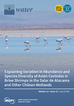
In the hypersaline lagoons of the Salar de Atacama in Chile, Redón et al. (2021) investigated the cestode parasites (tapeworms) of flamingos and other waterbirds that have larvae living in brine shrimps (Artemia franciscana) as intermediate hosts. Most cestodes recorded were of three species that parasitize flamingos, but 11% were of species that parasitize shorebirds. They compared these results with those from lower salinity wetlands in Patagonia, frequented by another brine shrimp, A. persimilis. The differences reflect the changes in the waterbird community: there were fewer flamingo parasites in Patagonia, and around half the cestodes were parasites of ducks and grebes that were absent in Atacama. The image shows the Andean flamingo, Phoenicoparrus andinus, in the Salar de Atacama. View this paper
  • Issues are regarded as officially published after their release is announced to the table of contents alert mailing list.
  • You may sign up for e-mail alerts to receive table of contents of newly released issues.
  • PDF is the official format for papers published in both, html and pdf forms. To view the papers in pdf format, click on the "PDF Full-text" link, and use the free Adobe Reader to open them.
Order results
Result details
Section
Select all
Export citation of selected articles as:
27 pages, 5960 KiB  
Article
Modeling of the Hydrological Processes in Caatinga and Pasture Areas in the Brazilian Semi-Arid
by Lucas Ravellys Pyrrho de Alcântara, Artur Paiva Coutinho, Severino Martins dos Santos Neto, Ana Emília Carvalho de Gusmão da Cunha Rabelo and Antonio Celso Dantas Antonino
Water 2021, 13(13), 1877; https://doi.org/10.3390/w13131877 - 05 Jul 2021
Cited by 4 | Viewed by 2898
Abstract
The semi-arid regions of northeastern Brazil have historically suffered from water shortage. In this context, monitoring and modeling the soil moisture’s dynamics with hydrological models in natural (Caatinga) and degraded (Pasture) regions is of fundamental importance to understand the dynamics of hydrological processes. [...] Read more.
The semi-arid regions of northeastern Brazil have historically suffered from water shortage. In this context, monitoring and modeling the soil moisture’s dynamics with hydrological models in natural (Caatinga) and degraded (Pasture) regions is of fundamental importance to understand the dynamics of hydrological processes. Therefore, this work aims to evaluate the hydraulic parameters in Caatinga and Pasture areas using the Hydrus-1D inverse method. Thus, five soil hydraulic models present in Hydrus-1D were used, allowing the comparison of the single-porosity model with more complex models, which consider the dual porosity and the hysteresis of the porous medium. The hydraulic models showed better adjustments in the Caatinga area (RMSE = 0.01–0.02, R2 = 0.61–0.97) than in the Pasture area (RMSE = 0.01–0.03, R2 = 0.61–0.90). Regarding the hydraulic parameters, for all models, the Pasture showed smaller saturated hydraulic conductivity and water content values of the mobile region than the Caatinga. This fact demonstrates the negative impact of compaction and change in natural vegetation in the Brazilian semi-arid. The dual-porosity model presented the best fit to the data measured in the Pasture area. However, a single-porosity model could be considered representative of the Caatinga area. The results showed that Caatinga areas contribute to maintaining soil moisture and increasing the water storage in semi-arid regions. Full article
(This article belongs to the Section Hydrology)
Show Figures

Figure 1

18 pages, 2837 KiB  
Article
Comparison of Online Sensors for Liquid Phase Hydrogen Sulphide Monitoring in Sewer Systems
by Daneish Despot, Micaela Pacheco Fernández and Matthias Barjenbruch
Water 2021, 13(13), 1876; https://doi.org/10.3390/w13131876 - 05 Jul 2021
Cited by 7 | Viewed by 3925
Abstract
Hydrogen sulfide (H2S) related to wastewater in sewer systems is known for causing significant problems of corrosion and odor nuisance. Sewer systems severely affected by H2S typically rely on online H2S gas sensors for monitoring and control. [...] Read more.
Hydrogen sulfide (H2S) related to wastewater in sewer systems is known for causing significant problems of corrosion and odor nuisance. Sewer systems severely affected by H2S typically rely on online H2S gas sensors for monitoring and control. However, these H2S gas sensors only provide information about the H2S emission potential at the point being monitored, which is sometimes inadequate to design control measures. In this study, a comparison of three market-ready online sensors capable of liquid-phase H2S detection in sewer systems was assessed and compared. Two of the three sensors are based on UV/Vis spectrophotometry, while the other adapted the design and principles of a Clark-type electrochemical microsensor. The H2S measurements of the sensors were statistically compared to a standard laboratory method at first. Following that, the performance of the online sensors was evaluated under realistic sewer conditions using the Berlin Water Company (BWB) research sewer pilot plant. Test applications representing scenarios of typical H2S concentrations found in sulfide-affected sewers and during control measures were simulated. The UV/Vis spectrometers showed that the performance of the sensors was highly dependent on the calibration type and measurements used for deriving the calibration function. The electrochemical sensor showed high sensitivity by responding to alternating anaerobic/anoxic conditions simulated during nitrate dosing. All sensors were prone to measurement disturbances due to high amounts of sanitary solids in wastewater at the study site and required continuous maintenance for reliable measurements. Finally, a summary of the key attributes and limitations of the sensors compared for liquid phase H2S detection is outlined. Full article
(This article belongs to the Special Issue Urban Water Networks Modelling and Monitoring)
Show Figures

Figure 1

24 pages, 4489 KiB  
Article
Smart Water Infrastructures Laboratory: Reconfigurable Test-Beds for Research in Water Infrastructures Management
by Jorge Val Ledesma, Rafał Wisniewski and Carsten Skovmose Kallesøe
Water 2021, 13(13), 1875; https://doi.org/10.3390/w13131875 - 05 Jul 2021
Cited by 9 | Viewed by 3197
Abstract
The smart water infrastructures laboratory is a research facility at Aalborg University, Denmark. The laboratory enables experimental research in control and management of water infrastructures in a realistic environment. The laboratory is designed as a modular system that can be configured to adapt [...] Read more.
The smart water infrastructures laboratory is a research facility at Aalborg University, Denmark. The laboratory enables experimental research in control and management of water infrastructures in a realistic environment. The laboratory is designed as a modular system that can be configured to adapt the test-bed to the desired network. The water infrastructures recreated in this laboratory are district heating, drinking water supply, and waste water collection systems. This paper focuses on the first two types of infrastructure. In the scaled-down network the researchers can reproduce different scenarios that affect its management and validate new control strategies. This paper presents four study-cases where the laboratory is configured to represent specific water distribution and waste collection networks allowing the researcher to validate new management solutions in a safe environment. Thus, without the risk of affecting the consumers in a real network. The outcome of this research facilitates the sustainable deployment of new technology in real infrastructures. Full article
Show Figures

Figure 1

14 pages, 3303 KiB  
Article
Experimental Analysis of Incipient Motion for Uniform and Graded Sediments
by Khabat Khosravi, Amir H. N. Chegini, Luca Mao, Jose F. Rodriguez, Patricia M. Saco and Andrew D. Binns
Water 2021, 13(13), 1874; https://doi.org/10.3390/w13131874 - 05 Jul 2021
Cited by 3 | Viewed by 2992
Abstract
So far, few studies have focused on the concept of critical flow velocity rather than bed shear stress for incipient sediment motion. Moreover, few studies have focused on sediment mixtures (graded sediment) and shape rather than uniform sediment for incipient motion condition. Different [...] Read more.
So far, few studies have focused on the concept of critical flow velocity rather than bed shear stress for incipient sediment motion. Moreover, few studies have focused on sediment mixtures (graded sediment) and shape rather than uniform sediment for incipient motion condition. Different experiments were conducted at a hydraulic laboratory at the University of Guilan in 2015 to determine hydraulic parameters on the incipient motion condition. The aim of this study is to conduct a comparison between uniform and graded sediments, and a comparison between round and angular sediments. Experiments included rounded uniform bed sediments of 5.17, 10.35, 14 and 20.7 mm, angular uniform sediment of 10.35 mm, and graded sediment. Results demonstrated that angular sediment has a higher critical shear velocity than rounded sediment for incipient motion. Results also showed that for a given bed sediment, although critical shield stress and relative roughness increased with the bed slope, the particle Froude number (based on critical velocity) decreased. In terms of the sediment mixture, the critical shear stress (Vc*) was higher for the graded sediment than for the three finer uniform sediment sizes. The finer fractions of the mixture have a higher particle Froude number than their corresponding uniform sediment value, while the coarser fractions of the mixture showed a lower stability than their corresponding uniform sediment value. Results demonstrated that the reduction in the particle Froude number was more evident in lower relative roughness conditions. The current study provides a clearer insight into the interaction between initial sediment transport and flow characteristic, especially particle Froude number for incipient motion in natural rivers where stream beds have different gravel size distribution. Full article
Show Figures

Figure 1

17 pages, 5547 KiB  
Article
Evaluation of Drought Resilience Reflecting Regional Characteristics: Focused on 160 Local Governments in Korea
by Chan-Wook Lee and Do-Guen Yoo
Water 2021, 13(13), 1873; https://doi.org/10.3390/w13131873 - 05 Jul 2021
Cited by 2 | Viewed by 2440
Abstract
It is critical to prepare appropriate responses and countermeasures against droughts caused by a complex hazard process as the range of its damage and duration are very large. In this study, 160 local governments in Korea evaluated drought resilience. A total of 18 [...] Read more.
It is critical to prepare appropriate responses and countermeasures against droughts caused by a complex hazard process as the range of its damage and duration are very large. In this study, 160 local governments in Korea evaluated drought resilience. A total of 18 qualitative and quantitative drought recovery indicators were selected to collect and analyze data from each region. Comparative analysis of indicators through regional drought assessment was conducted to derive results and present directions for enhancing resilience. Lastly, a resilience curve of drought that can utilize the results of the evaluation was suggested and applied to the actual region, and the results were analyzed. The proposed method can be expected to be used as a basic and essential resources to prepare various local government measures against drought. Full article
(This article belongs to the Special Issue Assessing and Managing Risk of Flood and Drought in a Changing World)
Show Figures

Figure 1

26 pages, 10575 KiB  
Article
Drainage of a Water Tank with Pipe Outlet Loaded by a Passive Rotor
by Mohamed Elgamal, Karim Kriaa and Mohamed Farouk
Water 2021, 13(13), 1872; https://doi.org/10.3390/w13131872 - 05 Jul 2021
Cited by 5 | Viewed by 3334
Abstract
The optimal design of pipe outlets is an essential objective for many engineering projects. For the first time, this paper reports the results of a laboratory investigation on the effect of using a passive rotor (added at the pipe outlet) on the outlet [...] Read more.
The optimal design of pipe outlets is an essential objective for many engineering projects. For the first time, this paper reports the results of a laboratory investigation on the effect of using a passive rotor (added at the pipe outlet) on the outlet performance. Different sizes and numbers of blades of rotors were considered. Through the Tracker software package, video and image processing techniques were applied to capture the temporal variations of the tank water depth and the passive rotor’s angular speed. In addition, a normalized average drainage rate (NADR) parameter is defined to quantify the changes in the tank drainage rate as a result of passive rotor utilization. It is noted that adding a 4-bladed symmetric passive rotor will increase NADR by up to 9.0%. The study also shows that the highest increase in NADR is attained when the rotor diameter size is approximately 1.73 times the pipe outlet’s diameter for the case of symmetric 4-blade rotors, and the corresponding average tip rotor speed ratio is 1.65. It is also found that using an asymmetric 3-blade rotor has a negative impact on the NADR due to the significant perturbation produced by the rotor asymmetry. Full article
(This article belongs to the Section Oceans and Coastal Zones)
Show Figures

Figure 1

19 pages, 5773 KiB  
Article
Analysis of Flood Fatalities in the United States, 1959–2019
by Zhongyu Han and Hatim O. Sharif
Water 2021, 13(13), 1871; https://doi.org/10.3390/w13131871 - 05 Jul 2021
Cited by 6 | Viewed by 3997
Abstract
Flooding is one of the main weather-related disasters that cause numerous fatalities every year across the globe. This study examines flood fatalities reported in the contiguous United States (US) from 1959 to 2019. The last two decades witnessed major flood events, changing the [...] Read more.
Flooding is one of the main weather-related disasters that cause numerous fatalities every year across the globe. This study examines flood fatalities reported in the contiguous United States (US) from 1959 to 2019. The last two decades witnessed major flood events, changing the ranking of the top states compared to previous studies, with the exception of Texas, which had significantly higher flood-related fatalities than any other state. The rankings of counties within some states changed as well. The study aims to improve understanding of the situational conditions, demographics, and spatial and temporal characteristics associated with flood fatalities. The analysis reveals that flash flooding is associated with more fatalities than other flood types. In general, males are much more likely to be killed in floods than females. The analysis also suggests that people in the age groups of 10–19, 20–29, and 0–9 are the most vulnerable to flood hazard. Purposely driving or walking into floodwaters accounts for more than 86% of total flood fatalities. Thus, the vast majority of flood fatalities are preventable. The results will help identify the risk factors associated with different types of flooding and the vulnerability of the exposed communities. Full article
(This article belongs to the Section Hydrology)
Show Figures

Figure 1

24 pages, 2141 KiB  
Article
Advances in Egyptian Mediterranean Coast Climate Change Monitoring
by Matteo Gentilucci, Abdelraouf A. Moustafa, Fagr Kh. Abdel-Gawad, Samira R. Mansour, Maria Rosaria Coppola, Lidia Caserta, Sara Inglese, Gilberto Pambianchi and Giulia Guerriero
Water 2021, 13(13), 1870; https://doi.org/10.3390/w13131870 - 05 Jul 2021
Cited by 13 | Viewed by 4085
Abstract
This paper characterizes non-indigenous fish species (NIS) and analyses both atmospheric and sea surface temperatures for the Mediterranean coast of Egypt from 1991 to 2020, in relation to previous reports in the same areas. Taxonomical characterization depicts 47 NIS from the Suez Canal [...] Read more.
This paper characterizes non-indigenous fish species (NIS) and analyses both atmospheric and sea surface temperatures for the Mediterranean coast of Egypt from 1991 to 2020, in relation to previous reports in the same areas. Taxonomical characterization depicts 47 NIS from the Suez Canal (Lessepsian/alien) and 5 from the Atlantic provenance. GenBank accession number of the NIS mitochondrial gene, cytochrome oxidase 1, reproductive and commercial biodata, and a schematic Inkscape drawing for the most harmful Lessepsian species were reported. For sea surface temperatures (SST), an increase of 1.2 °C to 1.6 °C was observed using GIS software. The lack of linear correlation between annual air temperature and annual SST at the same detection points (Pearson r) could suggest a difference in submarine currents, whereas the Pettitt homogeneity test highlights a temperature breakpoint in 2005–2006 that may have favoured the settlement of non-indigenous fauna in the coastal sites of Damiette, El Arish, El Hammam, Alexandria, El Alamain, and Mersa Matruh, while there seems to be a breakpoint present in 2001 for El Sallum. This assessment of climate trends is in good agreement with the previous sightings of non-native fish species. New insights into the assessment of Egyptian coastal climate change are discussed. Full article
(This article belongs to the Special Issue Climate Impact on Sustainability of Aquatic Organisms)
Show Figures

Figure 1

15 pages, 10708 KiB  
Article
Controlling the Structural Robustness of Zirconium-Based Metal Organic Frameworks for Efficient Adsorption on Tetracycline Antibiotics
by Hee-Gon Kim, Keunsu Choi, Kibong Lee, Soonjae Lee, Kyung-Won Jung and Jae-Woo Choi
Water 2021, 13(13), 1869; https://doi.org/10.3390/w13131869 - 05 Jul 2021
Cited by 14 | Viewed by 3462
Abstract
Tetracyclines (TCs) are the most widely used antibiotics for the prevention and treatment of livestock diseases, but they are toxic to humans and have frequently been detected in water bodies. In this study, the physical and chemical properties of the zirconium-based metal organic [...] Read more.
Tetracyclines (TCs) are the most widely used antibiotics for the prevention and treatment of livestock diseases, but they are toxic to humans and have frequently been detected in water bodies. In this study, the physical and chemical properties of the zirconium-based metal organic framework (MOF) UiO-66 and its NH2-functionalized congener UiO-66-NH2 were investigated along with batch TC adsorption tests to determine the effect of functionalization on TC removal. TC removal was highest at pH 3 and decreased with increasing pH. Pseudo-1st and pseudo-2nd-order kinetic models were used to study the adsorption equilibrium times, and Langmuir isotherm model was found to be more suitable than Freundlich model. The maximum uptake for UiO-66 and UIO-66-NH2 was measured to be 93.6 and 76.5 mg/g, respectively. Unexpectedly, the TC adsorption capacity of UiO-66-NH2 was observed to be lower than that of UiO-66. Density functional theory calculations revealed that the pore structures are irrelevant to TC adsorption, and that the –NH2 functional group could weaken the structural robustness of UiO-66-NH2, causing a reduction in TC adsorption capacity. Accordingly, robust MOFs with zirconium-based metal clusters can be effectively applied for the treatment of antibiotics such as TC in water. Full article
(This article belongs to the Section Wastewater Treatment and Reuse)
Show Figures

Figure 1

16 pages, 6701 KiB  
Article
3D Numerical Simulation of Gravity-Driven Motion of Fine-Grained Sediment Deposits in Large Reservoirs
by Dongdong Jia, Jianyin Zhou, Xuejun Shao and Xingnong Zhang
Water 2021, 13(13), 1868; https://doi.org/10.3390/w13131868 - 04 Jul 2021
Cited by 1 | Viewed by 2209
Abstract
Deposits in dam areas of large reservoirs, which are commonly composed of fine-grained sediment, are important for reservoir operation. Since the impoundment of the Three Gorges Reservoir (TGR), the sedimentation pattern in the dam area has been unexpected. An integrated dynamic model for [...] Read more.
Deposits in dam areas of large reservoirs, which are commonly composed of fine-grained sediment, are important for reservoir operation. Since the impoundment of the Three Gorges Reservoir (TGR), the sedimentation pattern in the dam area has been unexpected. An integrated dynamic model for fine-grained sediment, which consists of both sediment transport with water flow and gravity-driven fluid mud at the bottom, was proposed. The incipient motion driven by gravity in the form of fluid mud was determined by the critical slope. Shallow flow equations were simplified to simulate the gravity-driven mass transport. The gravity-driven flow model was combined with a 3D Reynolds-averaged water flow and sediment transport model. Solution routines were developed for both models, which were then used to simulate the integral movement of the fine-grained sediment. The simulated sedimentation pattern agreed well with observations in the dam area of the TGR. Most of the deposits were found at the bottom of the main channel, whereas only a few deposits remained on the bank slopes. Due to the gravity-driven flow of fluid mud, the deposits that gathered in the deep channel formed a nearly horizontal surface. By considering the gravity-driven flow, the averaged error of deposition thickness along the thalweg decreased from −13.9 to 2.2 m. This study improved our understanding of the mechanisms of fine-grained sediment transport in large reservoirs and can be used to optimize dam operations. Full article
(This article belongs to the Special Issue Modelling of River Flows, Sediment and Contaminants Transport)
Show Figures

Figure 1

22 pages, 2140 KiB  
Article
Methane Production and Oxidation in Mangrove Soils Assessed by Stable Isotope Mass Balances
by Salvador Sánchez-Carrillo, Jaime Garatuza-Payan, Raquel Sánchez-Andrés, Francisco J. Cervantes, María Carmen Bartolomé, Martín Merino-Ibarra and Frederic Thalasso
Water 2021, 13(13), 1867; https://doi.org/10.3390/w13131867 - 04 Jul 2021
Cited by 4 | Viewed by 3643
Abstract
Considerable variability in methane production and emissions has been reported in mangroves, explained by methane inhibition and oxidation. In this study, soil pore waters were collected from mangrove forests located in the Gulf of California (Mexico) exposed to shrimp farm disturbance. The δ [...] Read more.
Considerable variability in methane production and emissions has been reported in mangroves, explained by methane inhibition and oxidation. In this study, soil pore waters were collected from mangrove forests located in the Gulf of California (Mexico) exposed to shrimp farm disturbance. The δ13C of dissolved inorganic carbon (DIC) and CH4 were analyzed along with the δ13C of the soil organic matter to assess the proportion of CO2 derived from methanogenesis, its main pathway, and the fraction of methane oxidized. We performed slurry incubation experiments to fit the isotope–mass balance approach. Very low stoichiometric ratios of CH4/CO2 were measured in pore waters, but isotope mass balances revealed that 30–70% of the total CO2 measured was produced by methanogenesis. Mangrove soils receiving effluent discharges shifted the main methanogenesis pathway to CO2 reduction because of an increase in refractory organic matter. Isotope–mass balances of incubations indicated that methane was mainly oxidized by anaerobic oxidation of methane (AOM) coupled to sulfate reduction, and the increase in recalcitrant organic matter should fuel AOM as humus serves as a terminal electron acceptor. Since methanogenesis in mangrove soils is strongly controlled by the oxygen supply provided by mangrove roots, conservation of the forest plays a crucial role in mitigating greenhouse gas emissions. Full article
Show Figures

Figure 1

17 pages, 4044 KiB  
Article
Freshwater–Saltwater Interactions in a Multilayer Coastal Aquifer (Ostia Antica Archaeological Park, Central ITALY)
by Margherita Bonamico, Paola Tuccimei, Lucia Mastrorillo and Roberto Mazza
Water 2021, 13(13), 1866; https://doi.org/10.3390/w13131866 - 04 Jul 2021
Cited by 2 | Viewed by 3219
Abstract
An integrated research approach consisting of hydrogeologic and geochemical methods was applied to a coastal aquifer in the Ostia Antica archaeological park, Roma, Italy, to describe freshwater–saltwater interactions. The archaeological park of Ostia Antica is located on the left bank of the Tevere [...] Read more.
An integrated research approach consisting of hydrogeologic and geochemical methods was applied to a coastal aquifer in the Ostia Antica archaeological park, Roma, Italy, to describe freshwater–saltwater interactions. The archaeological park of Ostia Antica is located on the left bank of the Tevere River delta which developed on a morphologically depressed area. The water monitoring program included the installation of multiparametric probes in some wells inside the archaeological area, with continuous measurement of temperature, electrical conductivity, and water table level. Field surveys, water sampling, and major elements and bromide analyses were carried out on a seasonal basis in 2016. In order to understand the detailed stratigraphic setting of the area, three surface boreholes were accomplished. Two distinct circulations were identified during the dry season, with local interaction in the rainy period: an upper one within the archaeological cover, less saline and with recharge inland; and a deeper one in the alluvial materials of Tevere River, affected by salinization. Oxygen and carbon isotopic signature of calcite in the sediments extracted from the boreholes, along with major elements and Br concentration, allowed us to recognize the sources of salinity (mainly, local interaction with Roman salt pans and agricultural practices) and the processes of gas–water–rock interaction occurring in the area. All these inferences were confirmed and strengthened by PCA analysis of physicochemical data of groundwater. Full article
Show Figures

Figure 1

19 pages, 6916 KiB  
Article
Yield Stress Model for Natural Debris Flows in Presence of Fine and Coarse–Grained Sediments
by Leonardo Schippa
Water 2021, 13(13), 1865; https://doi.org/10.3390/w13131865 - 04 Jul 2021
Cited by 3 | Viewed by 2468
Abstract
When dealing with natural geo–hazards, it is important to understand the influence of sediment sorting on debris flows. The presence of coarse fraction is one of the aspects which affects the rheological behaviour of natural viscous granular fluid mixtures. In this paper, experiments [...] Read more.
When dealing with natural geo–hazards, it is important to understand the influence of sediment sorting on debris flows. The presence of coarse fraction is one of the aspects which affects the rheological behaviour of natural viscous granular fluid mixtures. In this paper, experiments on reconstituted debris flow mixtures with different coarse–to–fine sediment ratios are considered. Such mixtures behave just as non–Newtonian yield stress fluids and their rheological behaviour is largely affected by the presence of coarse fraction. Experimental results demonstrate that yield stress is very sensitive not only to bulk sediment concentration but also to coarse sediment fraction. A novel yield stress model is presented. It accounts for an empirical grading function depending on the coarse–to–fine grain content. The yield stress model performed satisfactorily in comparison with the experiments, showing that it is almost independent of the coarse–to–fine grain fraction in case of dominant coarse sediment content. Full article
Show Figures

Figure 1

20 pages, 8787 KiB  
Article
Estimation of Vegetation-Induced Flow Resistance for Hydraulic Computations Using Airborne Laser Scanning Data
by Peter Mewis
Water 2021, 13(13), 1864; https://doi.org/10.3390/w13131864 - 04 Jul 2021
Cited by 5 | Viewed by 2895
Abstract
The effect of vegetation in hydraulic computations can be significant. This effect is important for flood computations. Today, the necessary terrain information for flood computations is obtained by airborne laser scanning techniques. The quality and density of the airborne laser scanning information allows [...] Read more.
The effect of vegetation in hydraulic computations can be significant. This effect is important for flood computations. Today, the necessary terrain information for flood computations is obtained by airborne laser scanning techniques. The quality and density of the airborne laser scanning information allows for more extensive use of these data in flow computations. In this paper, known methods are improved and combined into a new simple and objective procedure to estimate the hydraulic resistance of vegetation on the flow in the field. State-of-the-art airborne laser scanner information is explored to estimate the vegetation density. The laser scanning information provides the base for the calculation of the vegetation density parameter ωp using the Beer–Lambert law. In a second step, the vegetation density is employed in a flow model to appropriately account for vegetation resistance. The use of this vegetation parameter is superior to the common method of accounting for the vegetation resistance in the bed resistance parameter for bed roughness. The proposed procedure utilizes newly available information and is demonstrated in an example. The obtained values fit very well with the values obtained in the literature. Moreover, the obtained information is very detailed. In the results, the effect of vegetation is estimated objectively without the assignment of typical values. Moreover, a more structured flow field is computed with the flood around denser vegetation, such as groups of bushes. A further thorough study based on observed flow resistance is needed. Full article
(This article belongs to the Section Hydraulics and Hydrodynamics)
Show Figures

Figure 1

24 pages, 10096 KiB  
Article
Living Benthic Foraminifera from the Surface and Subsurface Sediment Layers Applied to the Environmental Characterization of the Brazilian Continental Slope (SW Atlantic)
by Luciana Cristina de Carvalho Santa-Rosa, Sibelle Trevisan Disaró, Violeta Totah, Silvia Watanabe and Ana Tereza Bittencourt Guimarães
Water 2021, 13(13), 1863; https://doi.org/10.3390/w13131863 - 03 Jul 2021
Cited by 2 | Viewed by 3084
Abstract
Living benthic foraminifera (>63 µm) were studied to characterize the continental slope of the Potiguar Basin (SW Atlantic). Foraminifers from the surface (0–2 cm), subsurface (2–5 cm), and integrated (0–5 cm) sediment layers were analyzed to verify their contribution to environmental characterization. It [...] Read more.
Living benthic foraminifera (>63 µm) were studied to characterize the continental slope of the Potiguar Basin (SW Atlantic). Foraminifers from the surface (0–2 cm), subsurface (2–5 cm), and integrated (0–5 cm) sediment layers were analyzed to verify their contribution to environmental characterization. It was also estimated if and which changes occur when the subsurface is added. Sampling stations were distributed in five transects in four isobaths (150, 400, 1000, and 2000 m). Sediment samples were fixed with 4% buffered formaldehyde and stained with Bengal rose. Were recorded 396 species in the surface layer, 228 in the subsurface, and 449 in integrating both layers. This study did not include tubular agglutinated species. The assemblages from 150 m isobath indicated the upper slope, from 400 m indicated the middle slope and the ones from the 2000 m indicated the lower slope. The surface layer’s assemblage at 1000 m isobath was more similar to the middle slope; in contrast, its subsurface layer’s assemblage had more similarity with the lower slope. Rarefaction curves, Permanova, and NMDS routines indicated a high resemblance between surface and integrated layers. Therefore, the first two centimeters were sufficient to characterize this region based on living benthic foraminifera. Full article
Show Figures

Figure 1

20 pages, 3036 KiB  
Article
Anomaly Detection Using a Sliding Window Technique and Data Imputation with Machine Learning for Hydrological Time Series
by Lattawit Kulanuwat, Chantana Chantrapornchai, Montri Maleewong, Papis Wongchaisuwat, Supaluk Wimala, Kanoksri Sarinnapakorn and Surajate Boonya-aroonnet
Water 2021, 13(13), 1862; https://doi.org/10.3390/w13131862 - 03 Jul 2021
Cited by 33 | Viewed by 7993
Abstract
Water level data obtained from telemetry stations typically contains large number of outliers. Anomaly detection and a data imputation are necessary steps in a data monitoring system. Anomaly data can be detected if its values lie outside of a normal pattern distribution. We [...] Read more.
Water level data obtained from telemetry stations typically contains large number of outliers. Anomaly detection and a data imputation are necessary steps in a data monitoring system. Anomaly data can be detected if its values lie outside of a normal pattern distribution. We developed a median-based statistical outlier detection approach using a sliding window technique. In order to fill anomalies, various interpolation techniques were considered. Our proposed framework exhibited promising results after evaluating with F1-score and root mean square error (RMSE) based on our artificially induced data points. The present system can also be easily applied to various patterns of hydrological time series with diverse choices of internal methods and fine-tuned parameters. Specifically, the Spline interpolation method yielded a superior performance on non-cyclical data while the long short-term memory (LSTM) outperformed other interpolation methods on a distinct tidal data pattern. Full article
(This article belongs to the Section Hydrology)
Show Figures

Figure 1

16 pages, 4026 KiB  
Article
Uncertainty and Sensitivity Analysis of Input Conditions in a Large Shallow Lake Based on the Latin Hypercube Sampling and Morris Methods
by Min Pang, Ruichen Xu, Zhibing Hu, Jianjian Wang and Ying Wang
Water 2021, 13(13), 1861; https://doi.org/10.3390/w13131861 - 03 Jul 2021
Cited by 9 | Viewed by 2780
Abstract
We selected Tai Lake in China as the research area, and based on the Eco-lab model, we parameterized seven main external input conditions: discharge, carbon, nitrogen, phosphorus, wind speed, elevation, and temperature. We combined the LHS uncertainty analysis method and the Morris sensitivity [...] Read more.
We selected Tai Lake in China as the research area, and based on the Eco-lab model, we parameterized seven main external input conditions: discharge, carbon, nitrogen, phosphorus, wind speed, elevation, and temperature. We combined the LHS uncertainty analysis method and the Morris sensitivity analysis method to study the relationship between water quality and input conditions. The results showed that (1) the external input conditions had an uncertain impact on water quality. Among them, the uncertainties in total nitrogen concentration (TN) and total phosphorus concentration (TP) were mainly reflected in the lake entrance area, and the uncertainties of chlorophyll-a (Chl-a) and dissolved oxygen (DO) were mainly reflected in the lake center area. (2) The external input conditions had different sensitivities to different water layers. The bottom layer was most clearly and stably affected by input conditions. The TN and TP of the three different water layers were closely related to the flux into the lake, with average sensitivities of 83% and 78%, respectively. DO was mainly related to temperature and water elevation, with the bottom layer affected by temperatures as high as 98%. Chl-a was affected by all input factors except nitrogen and was most affected by wind speed, with an average of about 34%. Therefore, the accuracy of external input conditions can be effectively improved according to specific goals, reducing the uncertainty impact of the external input conditions of the model, and the model can provide a scientific reference for the determination of the mid- to long-term governance plan for Tai Lake in the future. Full article
(This article belongs to the Section Hydrology)
Show Figures

Figure 1

18 pages, 1042 KiB  
Article
Rainwater Use for Vertical Greenery Systems: Development of a Conceptual Model for a Better Understanding of Processes and Influencing Factors
by Flora Prenner, Bernhard Pucher, Irene Zluwa, Ulrike Pitha and Guenter Langergraber
Water 2021, 13(13), 1860; https://doi.org/10.3390/w13131860 - 03 Jul 2021
Cited by 11 | Viewed by 3613
Abstract
Vertical greenery systems (VGS) are promoted as a nature-based solution to mitigate the urban heat island effect. In order to ensure the long-term provision of this function, sufficiently available irrigation water is the key element. Currently, potable water is one of the main [...] Read more.
Vertical greenery systems (VGS) are promoted as a nature-based solution to mitigate the urban heat island effect. In order to ensure the long-term provision of this function, sufficiently available irrigation water is the key element. Currently, potable water is one of the main resources for irrigation of VGS. While rainwater is often mentioned as an alternative, only a few studies investigate the actual application of rainwater for irrigation. In this study a conceptual model is developed to present the processes and influencing factors for a holistic investigation of rainwater use for irrigation. In this model, five sub-modules are identified: the atmospheric, hydraulic, quality, rainwater harvesting and VGS sub-module. The conceptual model depicts which processes and influencing factors are involved in the water demand of VGS. Thus, the conceptual model supports a holistic understanding of the interrelations between the identified sub-modules and their relevance for VGS irrigation with harvested rainwater. The results of this study support the implementation of rainwater harvesting as a sustainable resource for VGS irrigation. Full article
(This article belongs to the Special Issue Water and Circular Cities)
Show Figures

Graphical abstract

3 pages, 148 KiB  
Obituary
Obituary in Remembrance of Tony Allan
by Winnie Gerbens-Leenes and Markus Berger
Water 2021, 13(13), 1859; https://doi.org/10.3390/w13131859 - 03 Jul 2021
Cited by 1 | Viewed by 3640
Abstract
It is with great sadness that we received the news that Tony Allan has passed away on the 15 April 2021 [...] Full article
22 pages, 2955 KiB  
Article
Impact of EU Environmental Policy Implementation on the Quality and Status of Greek Rivers
by Nikolaos Theodor Skoulikidis, Ioannis Karaouzas, Yorgos Amaxidis and Maria Lazaridou
Water 2021, 13(13), 1858; https://doi.org/10.3390/w13131858 - 03 Jul 2021
Cited by 16 | Viewed by 3343
Abstract
Based on historical and WFD-compliant data, the recent inter-annual ecological status and the long-term chemical-physicochemical quality trends of eighteen characteristic Greek rivers have been assessed and interpreted in view of implementing EU environmental policies and the evolution of human pressures. Considering predominating poor [...] Read more.
Based on historical and WFD-compliant data, the recent inter-annual ecological status and the long-term chemical-physicochemical quality trends of eighteen characteristic Greek rivers have been assessed and interpreted in view of implementing EU environmental policies and the evolution of human pressures. Considering predominating poor ecological status in most of the river outflows, the strengths and weaknesses of the WFD implementation have been highlighted. The long-term decrease of ammonium and nitrite concentrations along with relatively low recent BOD5 levels, indicate a general improvement of WWTP infrastructure in Greece and the other riparian countries, whereas the improvement of nitrate quality is attributed to the reduction of fertilizers use, and possibly, to the successful application of the Nitrates Directive in certain basins. Despite capacity building in governance and administrative infrastructure the recent years, River Basin Management Plans (RBMPs) are being implemented centrally, largely mechanistically, with minor public participation. Regarding WFD implementation weaknesses and gaps, concrete proposals have been formulated considering both policy/administrative and technical issues. To efficiently conserve and restore aquatic ecosystems, the forthcoming RBMPs should be consistent with ecosystem services principles focusing on nature-based solutions, along with changing attitudes of the state authorities and the public. Full article
Show Figures

Graphical abstract

15 pages, 3395 KiB  
Article
Characteristics of the Exchange Flow of the Bay of Quinte and Its Sheltered Embayments with Lake Ontario
by Jennifer A. Shore
Water 2021, 13(13), 1857; https://doi.org/10.3390/w13131857 - 03 Jul 2021
Viewed by 2285
Abstract
The nature of the exchange flow between the Bay of Quinte and Lake Ontario has been studied to illustrate the effects of the seasonal onset of stratification on the flushing and transport of material within the bay. Flushing is an important physical process [...] Read more.
The nature of the exchange flow between the Bay of Quinte and Lake Ontario has been studied to illustrate the effects of the seasonal onset of stratification on the flushing and transport of material within the bay. Flushing is an important physical process in bays used as drinking water sources because it affects phosphorous loads and water quality. A 2-d analytical model and a 3-dimensional numerical coastal model (FVCOM) were used together with in situ observations of temperature and water speed to illustrate the two-layer nature of the late summer exchange flow between the Bay of Quinte and Lake Ontario. Observations and model simulations were performed for spring and summer of 2018 and showed a cool wedge of bottom water in late summer extending from Lake Ontario and moving into Hay Bay at approximately 3 cm/s. Observed and modelled water speeds were used to calculate monthly averaged fluxes out of the Bay of Quinte. After the thermocline developed, Lake Ontario water backflowed into the Bay of Quinte at a rate approximately equal to the surface outflow decreasing the flushing rate. Over approximately 18.5 days of July 2018, the winds were insufficiently strong to break down the stratification, indicating that deeper waters of the bay are not well mixed. Particle tracking was used to illustrate how Hay Bay provides a habitat for algae growth within the bay. Full article
(This article belongs to the Section Hydraulics and Hydrodynamics)
Show Figures

Figure 1

17 pages, 8409 KiB  
Article
Spatiotemporal Variations of Water Vapor Content and Its Relationship with Meteorological Elements in the Third Pole
by Zhilan Wang, Meiping Sun, Xiaojun Yao, Lei Zhang and Hao Zhang
Water 2021, 13(13), 1856; https://doi.org/10.3390/w13131856 - 03 Jul 2021
Cited by 7 | Viewed by 2896
Abstract
Water vapor content plays an important role in climate change and the ecosystem in the Tibetan Plateau (TP) through its complicated interaction with the meteorological elements. However, due to the complex topography of the Tibetan Plateau, it is unreliable to attempt to understand [...] Read more.
Water vapor content plays an important role in climate change and the ecosystem in the Tibetan Plateau (TP) through its complicated interaction with the meteorological elements. However, due to the complex topography of the Tibetan Plateau, it is unreliable to attempt to understand the variation pattern of water vapor content using only observational data. Satellite and reanalysis data can be a good substitute for observational data, but their accuracy still needs to be evaluated. Therefore, based on radiosonde stations data, comprehensive assessment of water vapor content on the TP and surrounding areas derived from ERA-5, Second Modern-Era Retrospective analysis for Research and Applications (MERRA2), Atmospheric Infrared Sounder (AIRS)-only, and weighted ensemble data was performed in the context of spatial and temporal distribution at the annual and seasonal scale. Based on precipitation from Gauge V3.0 and Tropical Rainfall Measuring Mission satellite (TRMM) and temperature from ERA-5, the relationship between water vapor content and temperature and precipitation was analyzed. The results show that water vapor content decreases from southeast to northwest, and ERA-5, MERRA2, and AIRS-only can reasonably reproduce the spatial distribution of annual and seasonal water vapor content, with ERA-5 being more reliable in reproducing the spatial distribution. Over the past 50 years, the water vapor content has shown a gradual increasing trend. The variation trends of AIRS-only, MERRA2, ERA-5, and weighted ensemble data are almost consistent with the radiosonde stations data, with MERRA2 being more reliable in capturing water vapor content over time. Weighted ensemble data is more capable of capturing water vapor content characteristics than simple unweighted products. The empirical orthogonal function (EOF) analysis shows that the first spatial mode values of water vapor content and temperature are positive over the TP, while the values of precipitation present a “negative-positive-negative” distribution from south to north over the TP. In the second spatial mode of EOF analysis, the values of water vapor content, air temperature, and precipitation are all negative. The first temporal modes of EOF analysis, water vapor content, air temperature, and precipitation all show an increasing trend. In conclusion, there is a clear relationship of water vapor content with temperature and precipitation. Full article
Show Figures

Figure 1

16 pages, 22665 KiB  
Article
Hydrochemical and Isotopic Investigation of the Groundwater from Wajid Aquifer in Wadi Al-Dawasir, Southern Saudi Arabia
by Mohammed Benaafi and Abdulaziz Al-Shaibani
Water 2021, 13(13), 1855; https://doi.org/10.3390/w13131855 - 03 Jul 2021
Cited by 11 | Viewed by 3006
Abstract
The Wajid aquifer is considered the main source of water for drinking and irrigation in Wadi Al-Dawasir and Najran, the southern region of Saudi Arabia. This aquifer has been used since the 1960s, and due to the expansion in agricultural activities, the aquifer [...] Read more.
The Wajid aquifer is considered the main source of water for drinking and irrigation in Wadi Al-Dawasir and Najran, the southern region of Saudi Arabia. This aquifer has been used since the 1960s, and due to the expansion in agricultural activities, the aquifer has been overexploited. The study aims to understand the origin, hydrochemical processes of the groundwater in the shallow unconfined, deep unconfined, and confined parts of the Wajid aquifer in the Wadi Al-Dawasir area. In-situ hydrochemical parameters (pH, temperature, EC, and TDS) were measured in the field, and groundwater samples were collected for major ions and stable isotopes (2H and 18O) measurements in the laboratory. The results show that the groundwater in shallow unconfined, and confined aquifers are of two types; Cl.SO4-Ca. Na and Cl.SO4-Na. Ca; however, groundwater in deep, unconfined aquifers is characterized as HCO3-Ca. Na, and Cl. HCO3-Ca. Na; types of groundwater. The isotopic analysis results reveal that all groundwater samples have values of δ18Oand δ2Hclose to the local and global meteoric water lines, indicating the meteoric origin of Wajid groundwater. Three major hydrochemical processes, including rock weathering, ion exchange, and evaporation, have been identified as key controls on the chemical composition of water in the studied aquifer. The evaporation and ion exchange processes have more influence on the chemical composition of groundwater in the shallow unconfined and confined aquifers. On the contrary, weathering of carbonate minerals affected more the chemistry of groundwater in a deep unconfined aquifer. The unconfined section of the Wajid aquifer shows a reverse pattern of salinity with higher salinity in the recharge area, which is most probably related to the return irrigation water and leaching of salty soil. The open fractures in the upper part of Wajid sandstone most likely act as conduits to percolated saline water to the Wajid aquifer. Full article
(This article belongs to the Section Hydrology)
Show Figures

Figure 1

17 pages, 2719 KiB  
Article
Computational Fluid Dynamics Modelling and Analysis Approach for Estimating Internal Short-Circuiting in Clearwells
by Eunher Shin, Jewan Ryu and Heekyung Park
Water 2021, 13(13), 1849; https://doi.org/10.3390/w13131849 - 03 Jul 2021
Viewed by 2624
Abstract
Disinfection is an effective microorganism inactivation method that has contributed historically to decreasing waterborne diseases. It is necessary to improve hydraulic efficiency for ensuring disinfection ability without creating disinfection by-products. However, many hydraulic efficiency indices, which are a type of black-box analyses based [...] Read more.
Disinfection is an effective microorganism inactivation method that has contributed historically to decreasing waterborne diseases. It is necessary to improve hydraulic efficiency for ensuring disinfection ability without creating disinfection by-products. However, many hydraulic efficiency indices, which are a type of black-box analyses based on residence time distribution curves, have been used to assess short-circuiting and mixing. We propose a novel index (internal short-circuiting index, ISI) and analysis approach (internal short-circuiting estimation method, ISEM) based on computational fluid dynamics (CFD) modelling for understanding the local hydrodynamics. Then, we implement ISEM to quantify the effect of the clearwell configuration with the different length-to-width and shape ratios on the hydraulic efficiency. As the hydraulic efficiency surrogated by T10/T converges to the maximum value, the ISI values at inlet and outlet reduce rapidly, and the recirculation and dead zones shrink in the channel zones. Thus, the ISI curve changes from a V shape to U shape. The ISEM demonstrates that it is applicable under various conditions and it enables engineers to design clearwells for optimizing the disinfection ability. Furthermore, the CFD model in this study can be combined with machine learning techniques in future studies to extract knowledge for reducing the computational cost. Full article
(This article belongs to the Section Hydraulics and Hydrodynamics)
Show Figures

Figure 1

15 pages, 1452 KiB  
Article
Burrow Densities of Primary Burrowing Crayfishes in Relation to Prescribed Fire and Mechanical Vegetation Treatments
by Susan B. Adams, Scott G. Hereford and Chaz Hyseni
Water 2021, 13(13), 1854; https://doi.org/10.3390/w13131854 - 02 Jul 2021
Cited by 4 | Viewed by 3215
Abstract
Fire suppression and other factors have drastically reduced wet prairie and pine savanna ecosystems on the Coastal Plain of the southeastern United States. Restoration of these open-canopy environments often targets one or several charismatic species, and semi-aquatic species such as burrowing crayfishes are [...] Read more.
Fire suppression and other factors have drastically reduced wet prairie and pine savanna ecosystems on the Coastal Plain of the southeastern United States. Restoration of these open-canopy environments often targets one or several charismatic species, and semi-aquatic species such as burrowing crayfishes are often overlooked in these essentially terrestrial environments. We examined the relationship between primary burrowing crayfishes and three vegetation treatments implemented over at least the past two decades in the Mississippi Sandhill Crane National Wildlife Refuge. Vegetation in the 12 study sites had been frequently burned, frequently mechanically treated, or infrequently managed. Creaserinus spp., primarily C. oryktes, dominated the crayfish assemblage in every site. We counted crayfish burrow openings and coarsely categorized vegetation characteristics in 90, 0.56-m2 quadrats evenly distributed among six transects per site. The number of active burrow openings was negatively, exponentially related to both the percent cover of woody vegetation and the maximum height of woody vegetation in quadrats, and to the number of trees taller than 1.2 m per transect, indicating that woody plant encroachment was detrimental to the crayfishes. Results were consistent with several other studies from the eastern US, indicating that some primary burrowing crayfishes are habitat specialists adapted to open-canopy ecosystems. Full article
(This article belongs to the Special Issue Aquatic Biodiversity and Forests)
Show Figures

Figure 1

33 pages, 4113 KiB  
Review
Communicating for Aquatic Conservation in Cambodia and Beyond: Lessons Learned from In-Person and Media-Based Environmental Education and Outreach Strategies
by Erin K. Loury, Jackman C. Eschenroeder, Lykheang Seat, Seila Chea, Chheana Chhut, Suthep Kritsanavarin, Stefan Lovgren, Elizabeth G. Ramsay, Dee Thao and Zeb S. Hogan
Water 2021, 13(13), 1853; https://doi.org/10.3390/w13131853 - 02 Jul 2021
Cited by 2 | Viewed by 4423
Abstract
Communication and outreach efforts are essential for raising awareness about conservation issues among the general public. This paper reviews three in-person approaches (environmental education, outreach events, and field trips), as well as four types of media (print products, news media, visual media, and [...] Read more.
Communication and outreach efforts are essential for raising awareness about conservation issues among the general public. This paper reviews three in-person approaches (environmental education, outreach events, and field trips), as well as four types of media (print products, news media, visual media, and social media) for communicating about environmental topics, with a focus on highlighting conservation issues in Cambodia. Strengths and weaknesses are considered for each communication tool, along with lessons from a case study example of the Wonders of the Mekong, an interdisciplinary project based in Cambodia that aims to study, protect, and raise awareness about the Mekong River system. We also describe a cross-cutting initiative to share inspiring stories of local conservation practitioners that incorporates both in-person and media-based approaches. In terms of required resources and effort, there is an inherent tradeoff between the depth of in-person engagement and overall reach. While media-based approaches are valuable for reaching large numbers of people with a moderate amount of effort, in-person approaches may create a deeper connection and longer-term impact on an individual level. Ultimately, a diverse communication strategy that utilizes multiple tools to reach different audiences will be most effective. The interdisciplinary Wonders of the Mekong project has successfully communicated the values of the Mekong ecosystem to a broad audience in Cambodia using a variety of strategies, and further evaluation could help illuminate whether and how these communication approaches are shifting attitudes or promoting conservation behaviors. Full article
Show Figures

Figure 1

13 pages, 4460 KiB  
Article
Quantitative Evaluation of the Trade-Off Growth Strategies of Maize Leaves under Different Drought Severities
by Xueyan Ma, Guangsheng Zhou, Gen Li and Qiuling Wang
Water 2021, 13(13), 1852; https://doi.org/10.3390/w13131852 - 02 Jul 2021
Cited by 5 | Viewed by 2323
Abstract
The leaf is one of the most drought-sensitive plant organs. Investigating how leaf traits change and their trade-off growth during a drought would contribute to developing targeted drought-resistance measures. We investigated changes in five key maize leaf traits (leaf area, dry mass, effective [...] Read more.
The leaf is one of the most drought-sensitive plant organs. Investigating how leaf traits change and their trade-off growth during a drought would contribute to developing targeted drought-resistance measures. We investigated changes in five key maize leaf traits (leaf area, dry mass, effective number, water content, and specific weight) and their trade-off growth based on a drought simulation experiment. We also developed an indicator (0, 1) to quantitatively evaluate drought severity. The results showed a trade-off growth between different leaf traits of maize plants under drought conditions. Maize maintained relatively high leaf water content to maintain high leaf metabolic activity until drought severity was greater than 0. When drought severity was (0, 0.48), maize tended to adopt rapid growth strategy by maintaining regular leafing intensity and investing more energy into leaf area rather than specific leaf weight so that more energy could be absorbed. When the drought severity exceeded 0.48, maize conserved its resources for survival by maintaining relatively lower metabolic activity and thicker leaves to minimize water loss. The results provide an insight into the acclimation strategies of maize under drought, and contribute to targeted drought prevention and relief measures to reduce drought-induced risks to food security. Full article
(This article belongs to the Special Issue Soil Moisture Content and Crop Production Research)
Show Figures

Figure 1

17 pages, 4184 KiB  
Article
Using Cellular Automata Approach to Optimize the Hydropower Reservoir Operation of Folsom Dam
by Erfan Goharian, Mohammad Azizipour, Samuel Sandoval-Solis and Graham Fogg
Water 2021, 13(13), 1851; https://doi.org/10.3390/w13131851 - 02 Jul 2021
Cited by 3 | Viewed by 2665
Abstract
While hydropower in California is one the main sources of renewable energy, population growth has continuously increased demand for energy. In addition, recent droughts reduced the amount of available water behind the hydropower dams to provide the water head needed to run the [...] Read more.
While hydropower in California is one the main sources of renewable energy, population growth has continuously increased demand for energy. In addition, recent droughts reduced the amount of available water behind the hydropower dams to provide the water head needed to run the turbines in hydropower plants. A more sustainable alternative, instead of developing new infrastructure, is to enhance the daily operation of reservoirs to support hydropower generation. This study suggests a new optimal operation policy for Folsom Reservoir in California and hydropower plants, which maximizes hydropower generation and reduces flood risk. This study demonstrates the application of the cellular automata (CeA) approach to optimize the daily hydropower operation of Folsom Reservoir. The reservoir operation is a nonlinear problem, where the hydropower generation and elevation-area-storage functions are the main nonlinearity to accurately represent the daily operation of the system. Moreover, the performance of the CeA approach under two extreme climate conditions, wet and dry, was evaluated and compared to the operation during normal conditions. Results showed that the CeA approach provides more efficient solutions in comparison to the commonly used evolutionary optimization algorithms. For the size of the non-linear optimization problem designed in this study, CeA outperformed genetic algorithm for finding optimal solutions for different climate conditions. Results of CeA showed that although the annual average inflow to the reservoir during the dry period was about 30% less than the normal condition, CeA offered about a 20% reduction in average hydropower generation. The new operation policy offered by CeA can partly compensate for the loss of the snowpack in California’s Sierra Nevada under a warming climate. The approach and its outcomes support an informed decision-making process and provide practical reservoir operational guideline to remediate the adverse effects of hydroclimatic changes in the future. Full article
(This article belongs to the Section Water Resources Management, Policy and Governance)
Show Figures

Figure 1

17 pages, 14109 KiB  
Article
Water Data Explorer: An Open-Source Web Application and Python Library for Water Resources Data Discovery
by Giovanni Romero Bustamante, Everett James Nelson, Daniel P. Ames, Gustavious P. Williams, Norman L. Jones, Enrico Boldrini, Igor Chernov and Jorge Luis Sanchez Lozano
Water 2021, 13(13), 1850; https://doi.org/10.3390/w13131850 - 02 Jul 2021
Cited by 6 | Viewed by 5626
Abstract
We present the design and development of an open-source web application called Water Data Explorer (WDE), designed to retrieve water resources observation and model data from data catalogs that follow the WaterOneFlow and WaterML Service-Oriented Architecture standards. WDE is a fully customizable web [...] Read more.
We present the design and development of an open-source web application called Water Data Explorer (WDE), designed to retrieve water resources observation and model data from data catalogs that follow the WaterOneFlow and WaterML Service-Oriented Architecture standards. WDE is a fully customizable web application built using the Tethys Platform development environment. As it is open source, it can be deployed on the web servers of international government agencies, non-governmental organizations, research teams, and others. Water Data Explorer provides uniform access to international data catalogs, such as the Consortium of Universities for the Advancement of Hydrologic Science (CUAHSI) Hydrologic Information System (HIS) and the World Meteorological Organization (WMO) Hydrological Observing System (WHOS), as well as to local data catalogs that support the WaterOneFlow and WaterML standards. WDE supports data discovery, visualization, downloading, and basic data interpolation. It can be customized for different regions by modifying the user interface (i.e., localization), as well as by including pre-defined data catalogs and data sources. Access to WDE functionality is provided by a new open-source Python package called “Pywaterml” which provides programmable access to WDE methods to discover, visualize, download, and interpolate data. We present two case studies that access the CUAHSI HIS and WHOS catalogs and demonstrate regional customization, data discovery from WaterOneFlow web services, data visualization of time series observations, and data downloading. Full article
(This article belongs to the Special Issue Advances in Hydroinformatics for Water Data Management and Analysis)
Show Figures

Figure 1

27 pages, 6006 KiB  
Article
Social Hydrological Analysis for Poverty Reduction in Community-Managed Water Resources Systems in Cambodia
by Laura Forni, Susan Bresney, Sophia Espinoza, Angela Lavado, Marina RL Mautner, Jenny Yi-Chen Han, Ha Nguyen, Chap Sreyphea, Paula Uniacke, Luis Villarroel, Meloney Lindberg, Bernadette P. Resurrección and Annette Huber-Lee
Water 2021, 13(13), 1848; https://doi.org/10.3390/w13131848 - 02 Jul 2021
Cited by 1 | Viewed by 3509
Abstract
Achieving sustainable water resources management objectives can work in tandem with poverty reduction efforts. This study evidenced the strong social hydrological linkages that exist in Cambodia, which allowed for presenting a broader understanding of water resources challenges to better formulate and connect policies [...] Read more.
Achieving sustainable water resources management objectives can work in tandem with poverty reduction efforts. This study evidenced the strong social hydrological linkages that exist in Cambodia, which allowed for presenting a broader understanding of water resources challenges to better formulate and connect policies at the local and national levels. Models are often not developed with household- or community-level input, but rather with national- or coarse-level datasets. The method used in this study consisted of linking qualitative and quantitative social analysis with a previously developed technical water planning model. The results from the social inequalities analysis were examined for three water use types: domestic, rice production, and fishing in three parts of the watershed, namely, upstream, midstream, and downstream. Knowledge generated from the social analysis was used to refine previous water planning modeling. The model results indicate that without household data to consider social inequalities, the technical analysis for the Stung Chinit watershed was largely underrepresenting the shortages in irrigation supply seen by groups in the most downstream sections of the irrigation system. Without adding social considerations into the model, new policies or water infrastructure development suggested by the model could reinforce existing inequalities. Full article
(This article belongs to the Section Water Resources Management, Policy and Governance)
Show Figures

Figure 1

Previous Issue
Next Issue
Back to TopTop