Incremental Data Cube Architecture for Sentinel-2 Time Series: Multi-Cube Approaches to Dynamic Baseline Construction

Highlights
- We introduce a Multi-Cube architecture for Sentinel-2 time series that integrates spatial hashing, dynamic baseline policies, intelligent parallelism and automated subdivision of large areas into independent, temporally consistent cubes using Zarr-based storage. This design enables fully incremental and scalable data cube construction.
- Applied to 83,755 Sentinel-2 Level-2A images (2016–2024), the framework achieves 5.4× faster end-to-end processing and over two orders of magnitude less disk Input/Output than a conventional sequential pipeline, thanks to its incremental update engine and optimized multi-tile handling strategy.
- The framework provides interoperable cubes that grow incrementally and remain independent of analytical methods, allowing flexible integration with diverse workflows. This design offers a future oriented backbone for cloud-native EO systems, enabling analysts to adopt or replace algorithms without restructuring the data architecture and supporting reproducibility, long-term maintainability and seamless integration while also benefiting from shorter processing times.
- Beyond incremental ingestion, the architecture addresses the challenge of preserving temporal consistency across multi-tile areas by automatically generating stable and hash indexed units with coherent temporal baselines. This reduces mosaicking artifacts and configuration overhead, enabling reliable multi-year monitoring with minimal manual intervention.
Abstract
1. Introduction
2. Materials and Methods
2.1. Image Description
2.2. Reference-Processing Workflow
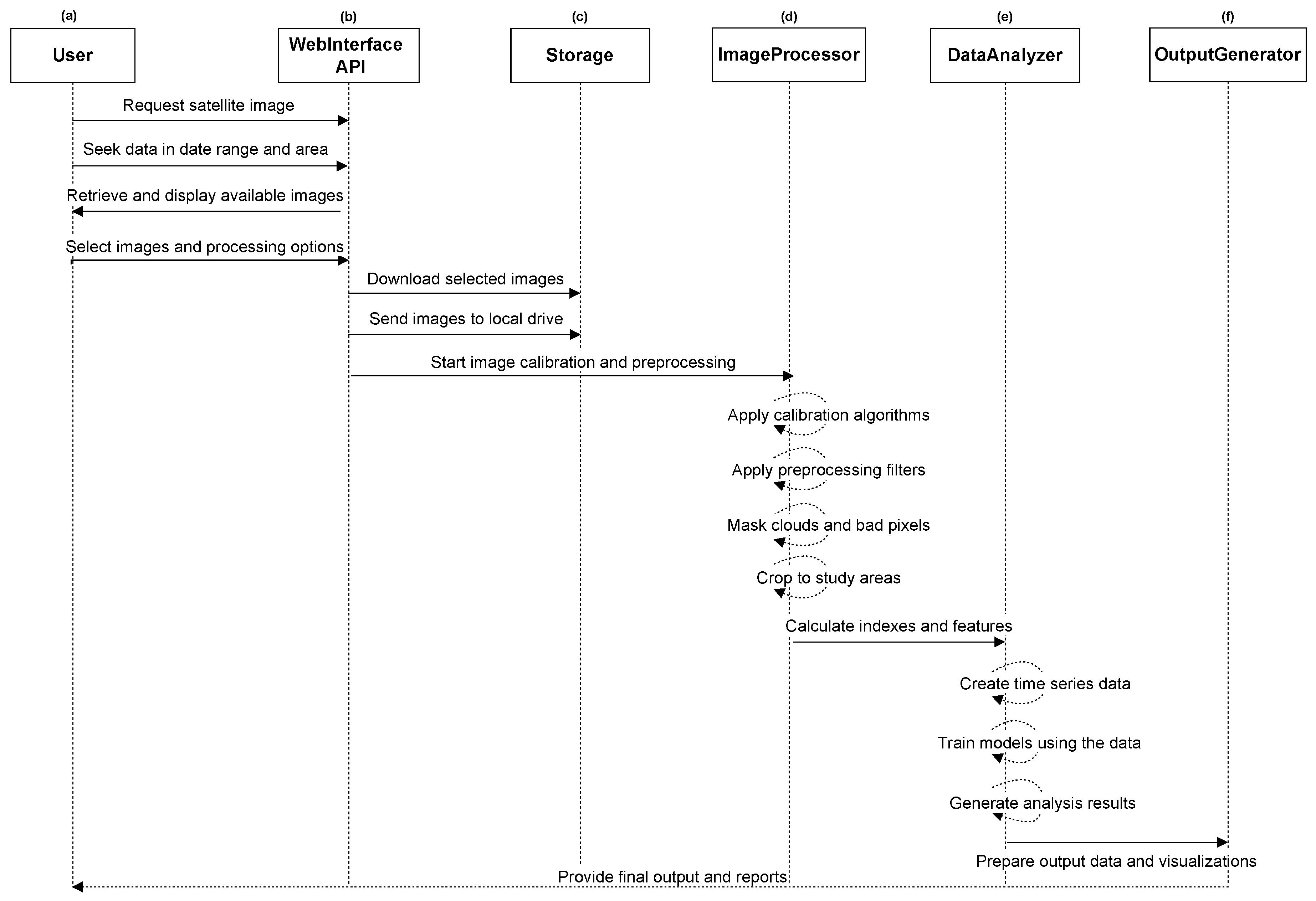
- WebInterface/API → Storage is bandwidth-bound (large SAFE granules);
- Storage → ImageProcessor is dominated by JPEG2000 decoding and repeated reads/writes during masking, resampling, and clipping;
- DataAnalyzer → OutputGenerator turns multi-tile and multiyear stacks into sizable artifacts and noticeable latencies whenever re-runs are triggered by new acquisitions or method updates.
2.3. Overview of the Multi-Cube Framework
2.4. Dynamic Baseline and Multi-Cube Construction
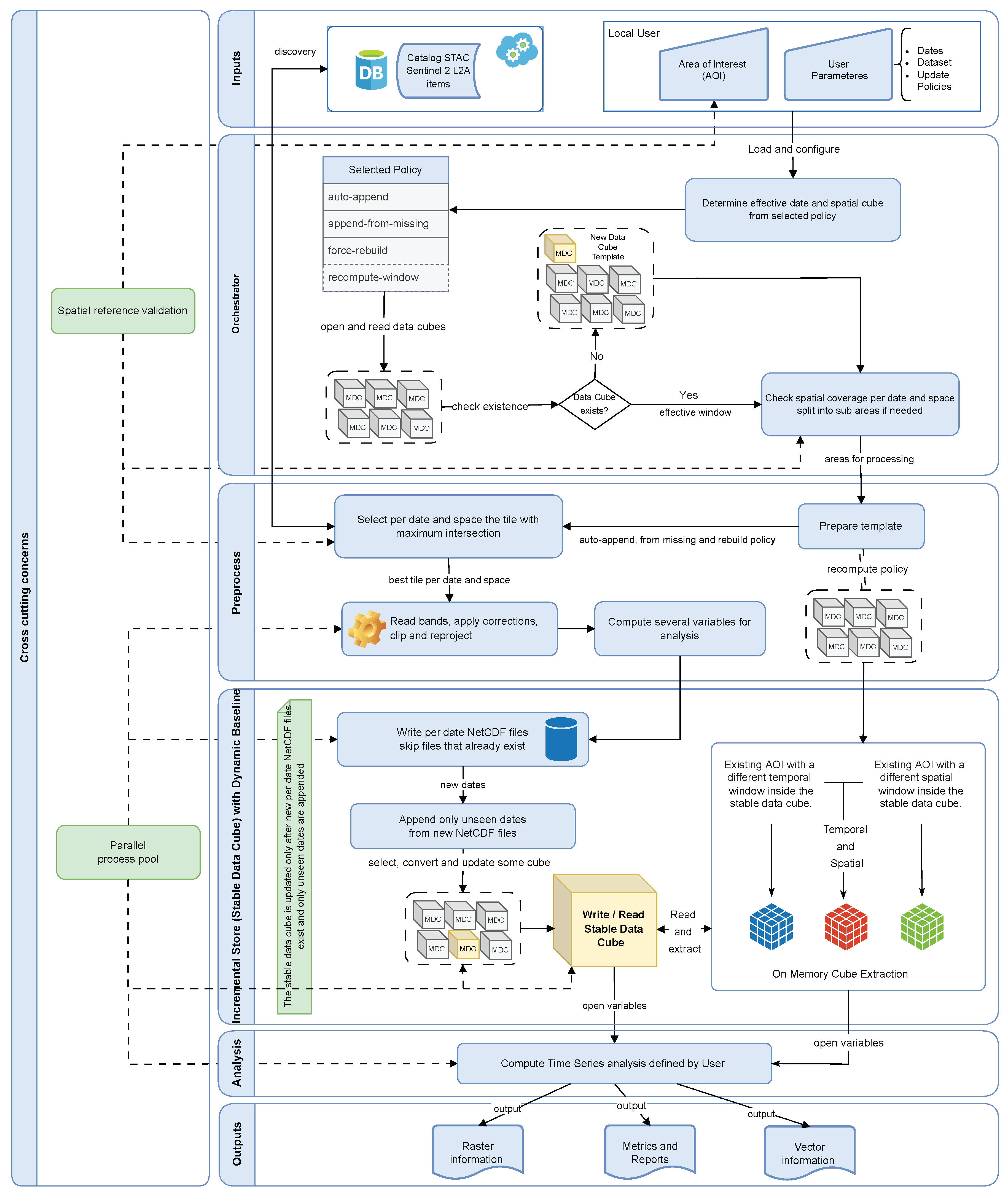
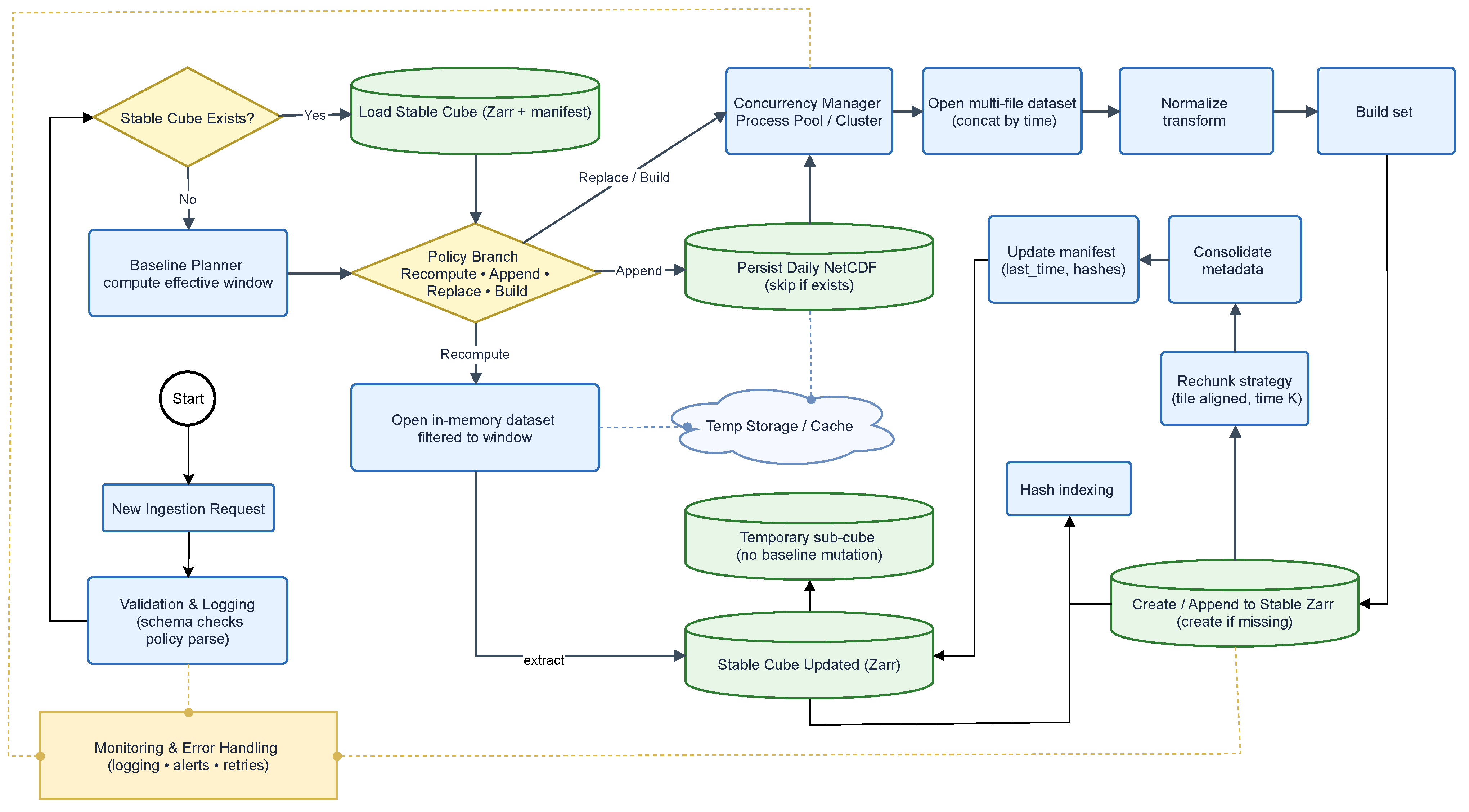
- auto-append, which extends the cube by appending only unseen dates after the last stored timestamp;
- append-from-missing, which reprocesses only those dates within the defined interval that were not successfully ingested, thereby filling temporal gaps;
- recompute-window, which isolates a specific temporal or spatial window and reconstructs it independently in memory, without affecting the stable baseline;
- force-rebuild, which creates or regenerates the entire cube when required.
2.5. Cloud and Parallel Processing
2.6. Decision-Driven Orchestrator for Incremental Workflows
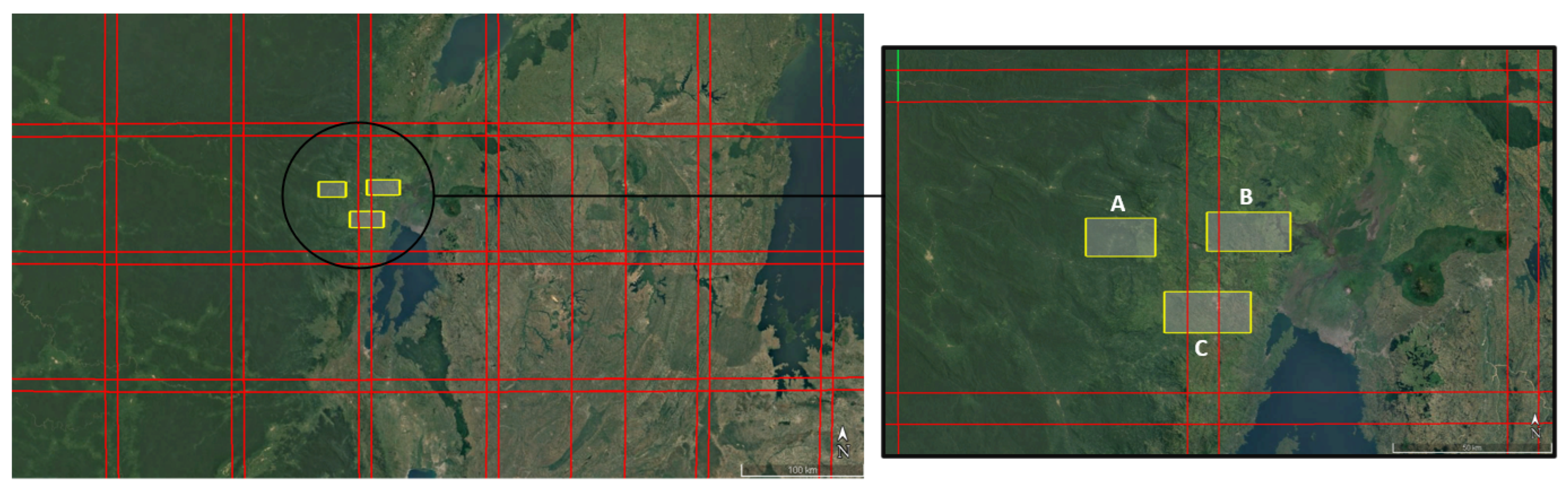
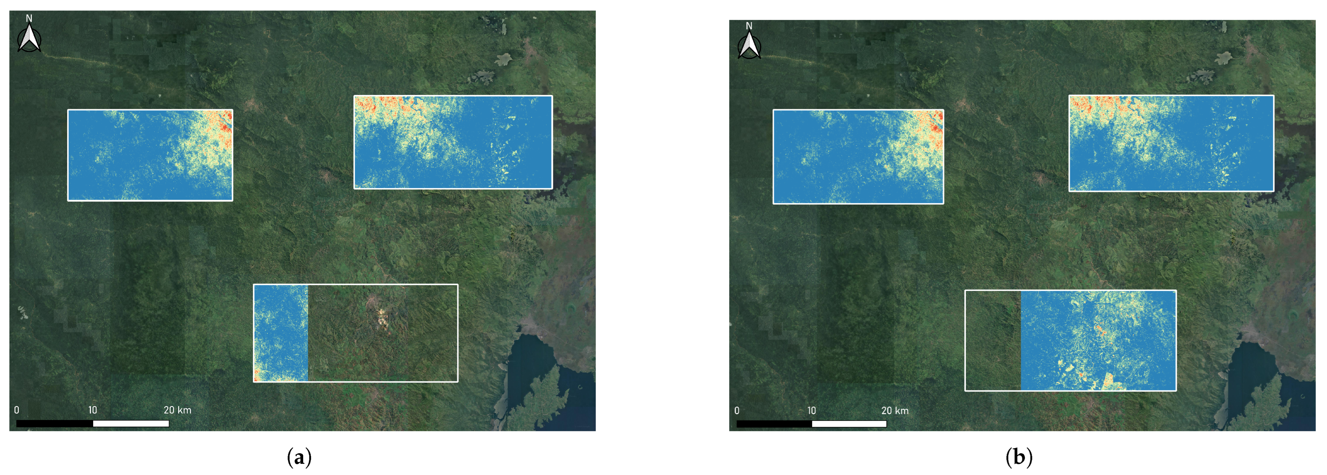
2.7. Study Area
3. Results
- Sentinel-2 Level 2A bands;
- Quality and SCL for masking clouds and shadows;
- Derived spectral indices;
- Metadata attributes standardized from the STAC, including acquisition date, tile ID, and quality indicators.
3.1. Performance Results
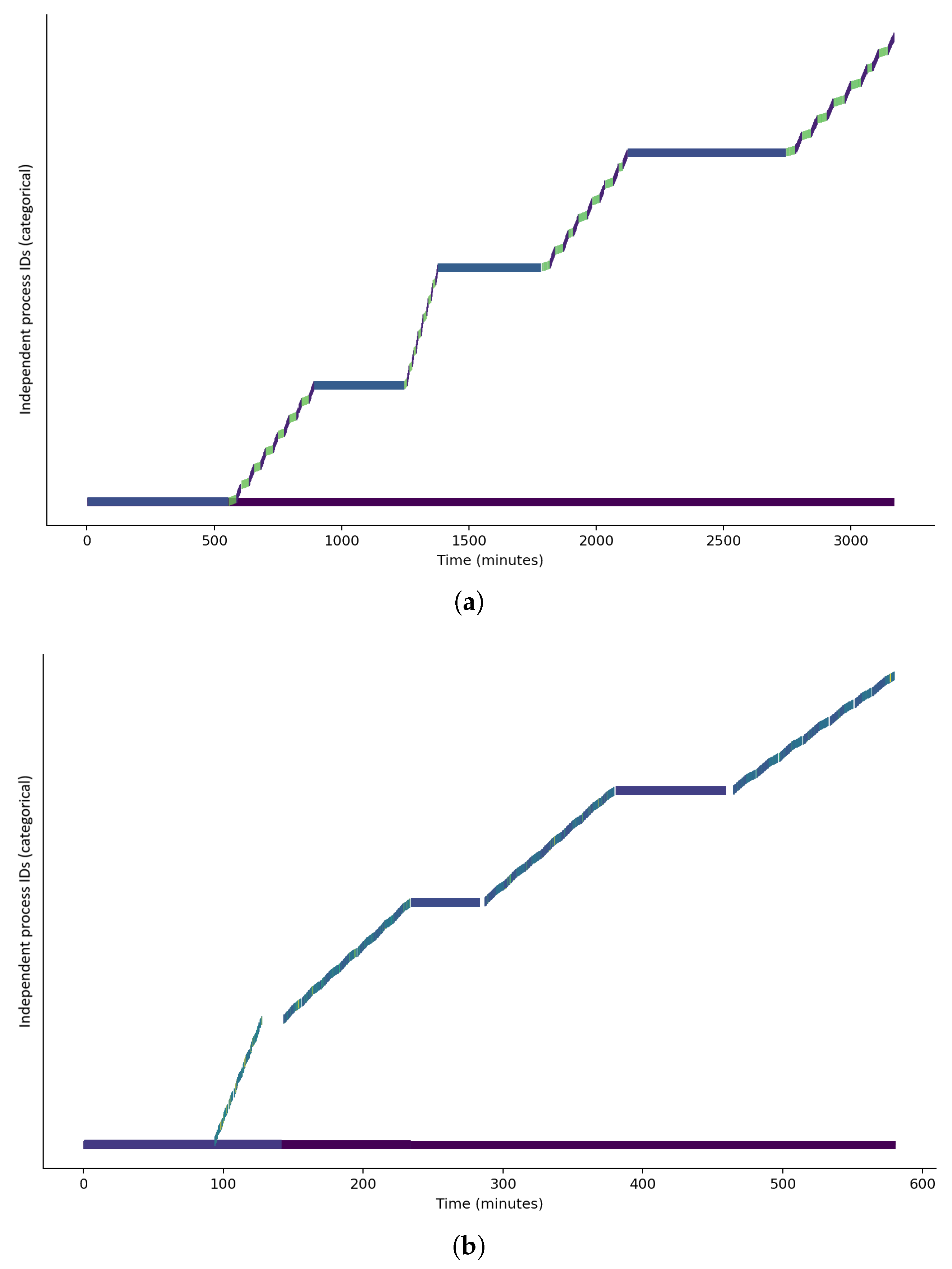
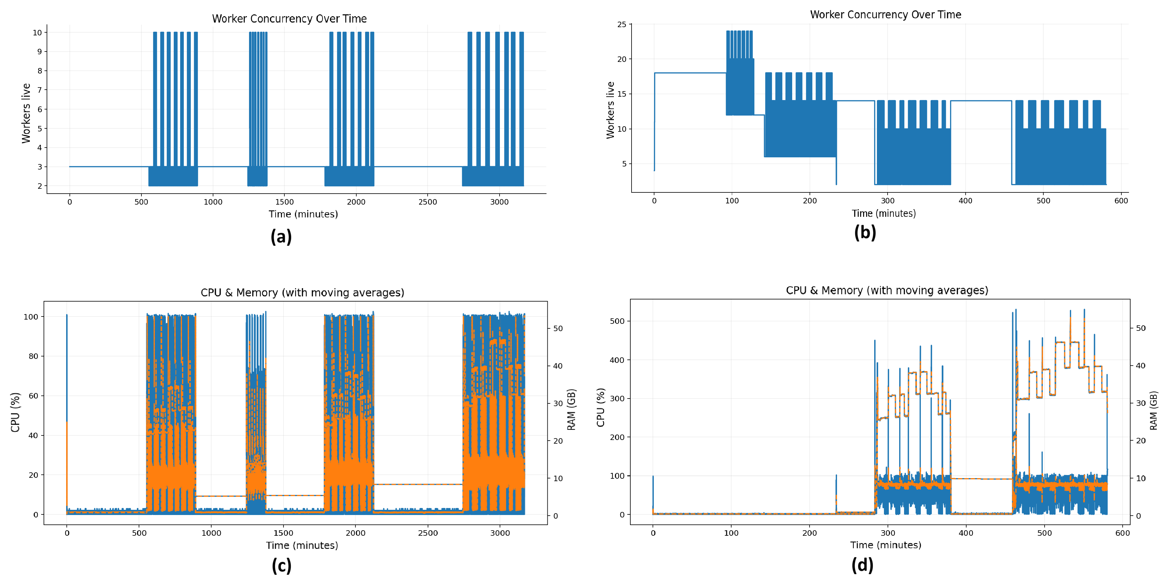
- The first experiment compared a sequential baseline mode, in which parallelization is deliberately suppressed to simulate the lower-bound computational cost, against the default configuration, where the Multi-Cube autonomously allocates workers and exploits multi-threading to optimize pipeline execution;
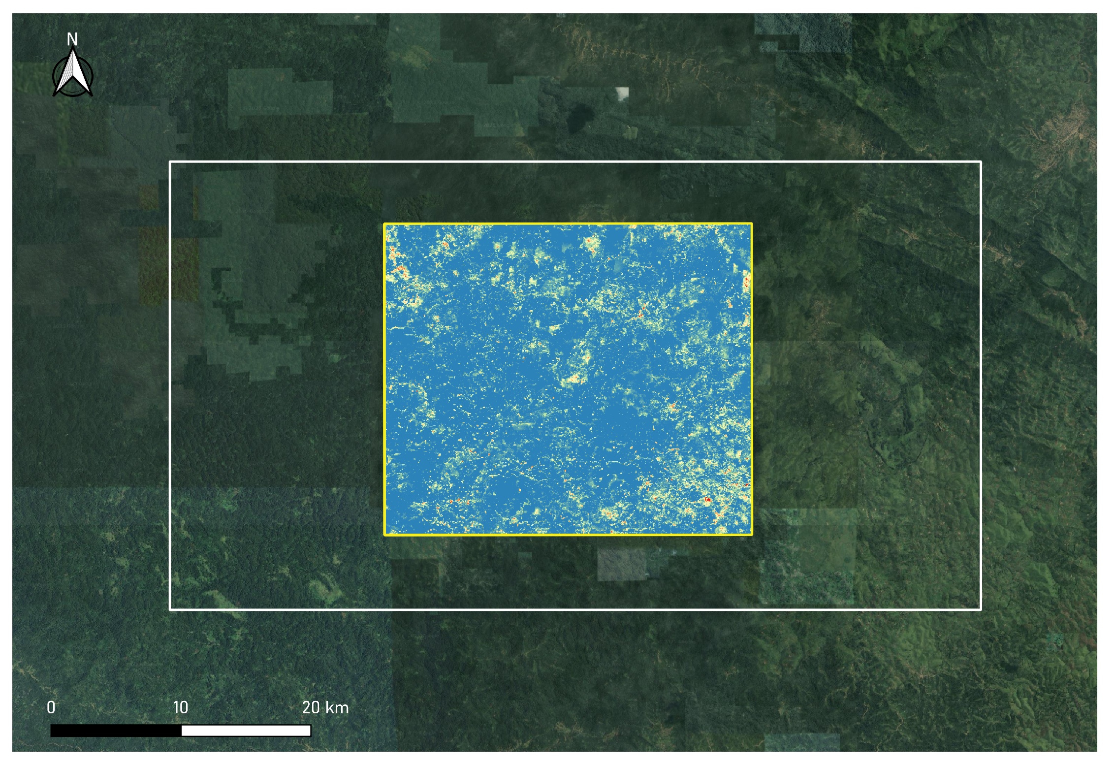
- The second experiment evaluated the framework’s ability to provide immediate access to sub-cubes in both temporal and spatial dimensions, enabling automated extraction of partial series or subsets, thereby contrasting with conventional approaches that require recalculating the full cube even for small AOIs.
3.1.1. Sequential Emulation vs. Adaptive Parallelization
- Execution is restricted to a single CPU core;
- Numerical and I/O libraries are limited to one processing thread;
- The is no subdivision of the time series into smaller sub-areas (tiling disabled);
- A single worker handles all stages (data loading, transformation, and computation), ensuring a strictly serial process.
- The framework automatically adjusts the number of workers assigned to each processing stage according to system capacity;
- Time series are divided into smaller independent spatial–temporal blocks that can be processed simultaneously;
- External numerical libraries are constrained to a controlled number of threads to prevent excessive contention for CPU resources;
- Data are read and processed in spatial and temporal chunks so that I/O and computation can proceed concurrently.
3.1.2. On-Demand Sub-Cube Access vs. Full-Cube Recalculation
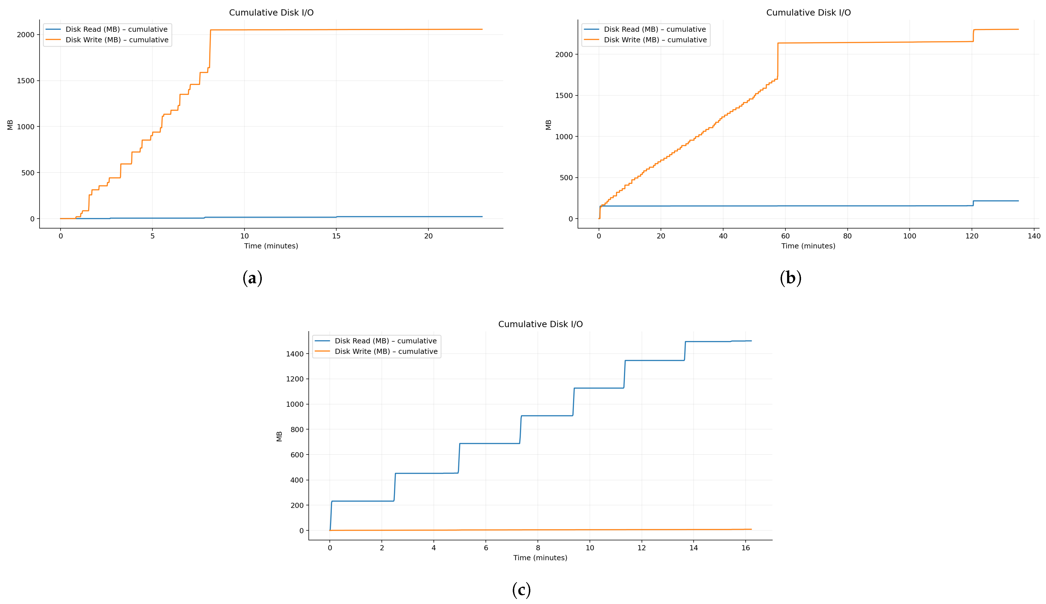
- Full-Cube Recalculation (Sequential Emulation), which rebuilds the entire pipeline for the AOI from ingestion to analysis, assuming no prior data exist;
- Full-Cube Recalculation (Optimized Parallel Execution), which rebuilds the entire AOI from scratch under the framework’s optimized parallel configuration;
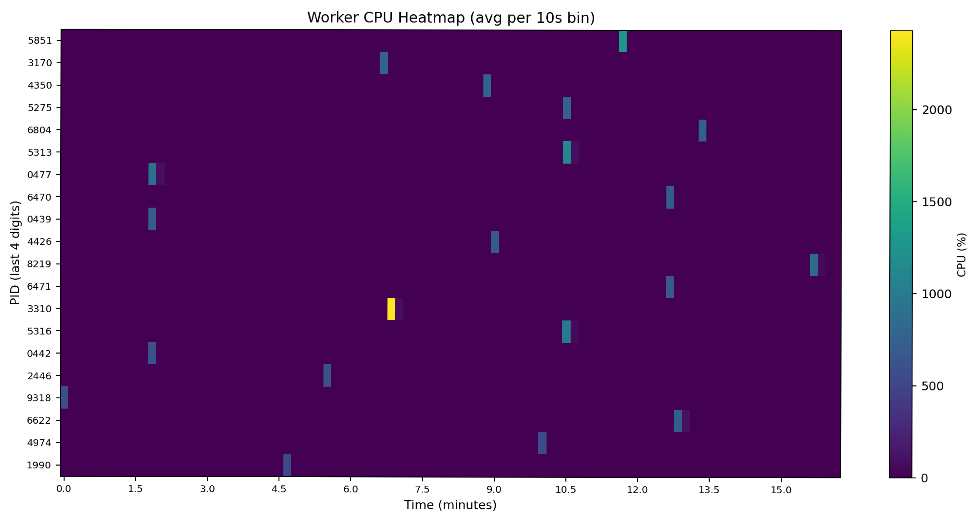
- On-Demand Sub-Cube Access, which avoids cube reconstruction by materializing an in-memory spatiotemporal sub-cube directly from the stable cube containing the requested area, writing only the analysis artifacts and leaving the dynamic baseline unchanged.
4. Discussion
Limitations and Edge Cases
5. Conclusions
Author Contributions
Funding
Data Availability Statement
Acknowledgments
Conflicts of Interest
References
- Durbha, S.; Sanyal, J.; Yang, L.; Chaudhari, S.; Bhangale, U.; Bharambe, U.; Kurte, K. Advances in Scalable and Intelligent Geospatial Analytics: Challenges and Applications; CRC Press: Boca Raton, FL, USA, 2023. [Google Scholar]
- Fu, Y.; Zhu, Z.; Liu, L.; Zhan, W.; He, T.; Shen, H.; Zhao, J.; Liu, Y.; Zhang, H.; Liu, Z.; et al. Remote Sensing Time Series Analysis: A Review of Data and Applications. J. Remote Sens. 2024, 4, 0285. [Google Scholar] [CrossRef] [Scilit]
- Kganyago, M.; Shikwambana, L. Assessment of the Characteristics of Recent Major Wildfires in the USA, Australia and Brazil in 2018–2019 Using Multi-Source Satellite Products. Remote Sens. 2020, 12, 1803. [Google Scholar] [CrossRef] [Scilit]
- Selea, T. AgriSen-COG, a Multicountry, Multitemporal Large-Scale Sentinel-2 Benchmark Dataset for Crop Mapping Using Deep Learning. Remote Sens. 2023, 15, 2980. [Google Scholar] [CrossRef] [Scilit]
- Tang, X.; Dong, S.; Luo, K.; Guo, J.; Li, L.; Sun, B. Noise Removal and Feature Extraction in Airborne Radar Sounding Data of Ice Sheets. Remote Sens. 2022, 14, 399. [Google Scholar] [CrossRef] [Scilit]
- Amoruso, A.; Crescentini, L.; Costa, R. Spatial Dispersion and Non-Negative Matrix Factorization of SAR Backscattering as Tools for Monitoring Snow Depth Evolution in Mountain Areas: A Case Study at Central Pyrenees (Spain). Remote Sens. 2022, 14, 653. [Google Scholar] [CrossRef] [Scilit]
- Deijns, A.A.J.; Michéa, D.; Déprez, A.; Malet, J.-P.; Kervyn, F.; Thiery, W.; Dewitte, O. A Semi-Supervised Multi-Temporal Landslide and Flash Flood Event Detection Methodology for Unexplored Regions Using Massive Satellite Image Time Series. ISPRS J. Photogramm. Remote Sens. 2024, 215, 400–418. [Google Scholar] [CrossRef] [Scilit]
- Badioui, K.; Van Griensven, A.; Verbeiren, B. Vegetation Monitoring of Palm Trees in an Oasis Environment (Boudenib, Morocco) Using Automatic Processing of Medium-Resolution Remotely Sensed Data. Geosciences 2025, 15, 104. [Google Scholar] [CrossRef] [Scilit]
- Zhao, L.; Qu, C.; Zhao, D.; Shan, X.; Chen, H.; Liu, L. InSAR Constrained Downdip and Updip Afterslip Following the 2015 Nepal Earthquake: New Insights into Moment Budget of the Main Himalayan Thrust. Remote Sens. 2022, 14, 306. [Google Scholar] [CrossRef] [Scilit]
- Fang, F.; Zhou, T.; Song, Z.; Lu, J. MMCAN: Multi-Modal Cross-Attention Network for Free-Space Detection with Uncalibrated Hyperspectral Sensors. Remote Sens. 2023, 15, 1142. [Google Scholar] [CrossRef] [Scilit]
- Sun, Z.; Cristea, N.; Tong, D.; Tullis, J.; Chester, Z.; Magill, A. A Review of Cyberinfrastructure for Machine Learning and Big Data in the Geosciences. In Cyberinfrastructure for Machine Learning and Big Data in the Geosciences; Geological Society of America: Boulder, CO, USA, 2023. [Google Scholar] [CrossRef] [Scilit]
- Dritsas, E.; Trigka, M. Remote Sensing and Geospatial Analysis in the Big Data Era: A Survey. Remote Sens. 2025, 17, 550. [Google Scholar] [CrossRef] [Scilit]
- Burgueño, A.M.; Aldana-Martín, J.F.; Vázquez-Pendón, M.; Barba-González, C.; Jiménez Gómez, Y.; García Millán, V.; Navas-Delgado, I. Scalable Approach for High-Resolution Land Cover: A Case Study in the Mediterranean Basin. J. Big Data 2023, 10, 91. [Google Scholar] [CrossRef] [Scilit]
- Iacono, L.L.; Gaitán, A.L.; Giraldo, F.X.; Ibarrola, L. SNDVI: A New Scalable Serverless Framework to Compute NDVI. Front. High Perform. Comput. 2023, 2, 1151530. [Google Scholar] [CrossRef] [Scilit]
- Michels, A.; Padmanabhan, A.; Xiao, Z.; Kotak, M.; Baig, F.; Wang, S. CyberGIS-Compute: Middleware for Democratizing Scalable Geocomputation. SoftwareX 2024, 26, 101691. [Google Scholar] [CrossRef] [Scilit]
- Xie, Z.; Game, E.T.; Phinn, S.R.; Adams, M.P.; Bayarjargal, Y.; Pannell, D.J.; Purevbaatar, G.; Baldangombo, B.; Hobbs, R.J.; Yao, J.; et al. A Scalable Big Data Approach for Remotely Tracking Rangeland Conditions. Commun. Earth Environ. 2024, 5, 349. [Google Scholar] [CrossRef] [Scilit]
- Adegun, A.A.; Viriri, S.; Tapamo, J.R. Review of Deep Learning Methods for Remote Sensing Satellite Images Classification: Experimental Survey and Comparative Analysis. J. Big Data 2023, 10, 93. [Google Scholar] [CrossRef] [Scilit]
- European Space Agency (ESA). Sentinel-2 User Guide: Mission Overview; ESA Technical Document; European Space Agency (ESA): Paris, France, 2021. [Google Scholar]
- European Space Agency (ESA). Sentinel-2 MSI—Spectral, Radiometric and Geometric Performance; ESA Technical Note; European Space Agency (ESA): Paris, France, 2021. [Google Scholar]
- European Space Agency. Sentinel-2 Level-1C Product Format Specification (SAFE/JP2); ESA Technical Document; European Space Agency (ESA): Paris, France, 2021. [Google Scholar]
- European Space Agency. Sen2Cor: Algorithm Theoretical Basis and L2A Product Definition; ESA Technical Document; European Space Agency (ESA): Paris, France, 2021. [Google Scholar]
- Weiss, M.; Jacob, F.; Duveiller, G. Remote Sensing for Agricultural Applications: A Meta-Review. Remote Sens. Environ. 2020, 236, 111402. [Google Scholar] [CrossRef] [Scilit]
- Pahlevan, N.; Smith, B.; Schalles, J.; Binding, C.; Cao, Z.; Ma, R.; Alikas, K.; Kangro, K.; Gurlin, D.; Greb, S.; et al. Seamless Retrievals of Chlorophyll-a from Sentinel-2 (MSI) and Sentinel-3 (OLCI) in Inland and Coastal Waters: A Machine-Learning Approach. Remote Sens. Environ. 2020, 240, 111604. [Google Scholar] [CrossRef] [Scilit]
- Li, W.; MacBean, N.; Ciais, P.; Defourny, P.; Lamarche, C.; Bontemps, S.; Houghton, R.A.; Peng, S. Gross and Net Land Cover Changes in the Main Plant Functional Types Derived From the Annual ESA CCI Land Cover Maps (1992–2015). Earth Syst. Sci. Data 2018, 10, 219–234. [Google Scholar] [CrossRef] [Scilit]
- Tang, X.; Barrett, M.G.; Cho, K.; Bratley, K.H.; Tarrio, K.; Zhang, Y.; Gu, H.; Rasmussen, P.; Bosch, M.; Woodcock, C.E. Broad-area-Search of New Construction Using Time Series Analysis of Landsat and Sentinel-2 Data. Sci. Remote Sens. 2024, 9, 100138. [Google Scholar] [CrossRef] [Scilit]
- Gaveau, D.L.A.; Descals, A.; Salim, M.A.; Sheil, D.; Sloan, S. Refined Burned-area Mapping Protocol Using Sentinel-2 Data Increases Estimate of 2019 Indonesian Burning. Earth Syst. Sci. Data 2021, 13, 5353–5368. [Google Scholar] [CrossRef] [Scilit]
- Louis, J.; Debaecker, V.; Pflug, B.; Main-Knorn, M.; Bieniarz, J.; Mueller-Wilm, U.; Cadau, E.; Gascon, F. Sen2Cor Level-2A Processor for Sentinel-2 Data. In Proceedings of the ESA Living Planet Symposium 2016, Prague, Czech Republic, 9–13 May 2016; ESA SP-740. Available online: https://elib.dlr.de/107381/1/LPS2016_sm10_3louis.pdf (accessed on 15 January 2025).
- ESA STEP Forum. Info: Introduction of Additional Radiometric Offset in PB04.00 Products. Online Forum Post. 2022. Available online: https://forum.step.esa.int/t/info-introduction-of-additional-radiometric-offset-in-pb04-00-products/35431 (accessed on 22 January 2025).
- Enache, S.; Louis, J.; Pflug, B.; de Los Reyes, R.; Lafrance, B.; Clerc, S.; Barrot, G.; Alhammoud, B.; Poustomis, F.; Iannone, R.Q.; et al. Copernicus Sentinel-2 Collection-1: A Consistent Dataset of Multispectral Imagery with Enhanced Quality. In Proceedings of the IEEE International Geoscience and Remote Sensing Symposium (IGARSS), Pasadena, CA, USA, 16–21 July 2023; pp. 4503–4506. [Google Scholar] [CrossRef] [Scilit]
- Copernicus Data Space Forum. Radiometric Offset of Sentinel-2 L2A/L1C Images. Online Resource. 2025. Available online: https://forum.dataspace.copernicus.eu/t/radiometric-offset-of-sentinel-2-l2a-l1c-images/3521 (accessed on 28 January 2025).
- Copernicus. Optical MPC Data Quality Report—Sentinel-2 MSI L2A (Issue 63). Technical Report. 2023. Available online: https://sentinels.copernicus.eu/documents/d/sentinel/ompc-cs-dqr-002-06-2023-i63r0-msi-l2a-dqr-july-2023 (accessed on 28 January 2025).
- Sudmanns, M.; Tiede, D.; Lang, S.; Bergstedt, H.; Trost, G.; Augustin, H.; Baraldi, A.; Blaschke, T. Big Earth Data: Disruptive Changes in Earth Observation Data Management and Analysis. Int. J. Digit. Earth 2020, 13, 832–850. [Google Scholar] [CrossRef] [Scilit]
- Munteanu, A. Data Cubes and Cloud-Native Environments for Earth Observation: An Overview. Scalable Comput. Pract. Exp. 2024, 25, 5745–5759. [Google Scholar] [CrossRef] [Scilit]
- Montero, D.; Kraemer, G.; Anghelea, A.; Aybar, C.; Brandt, G.; Camps-Valls, G.; Cremer, F.; Flik, I.; Gans, F.; Habershon, S.; et al. Earth System Data Cubes: Avenues for Advancing Earth System Research. Environ. Data Sci. 2024, 3, e27. [Google Scholar] [CrossRef] [Scilit]
- Ferreira, K.R.; Queiroz, G.R.; Marujo, R.F.B.; Costa, R.W. Building Earth Observation Data Cubes on AWS. In Proceedings of the International Archives of the Photogrammetry, Remote Sensing and Spatial Information Sciences, XLIII-B3-2022, Nice, France, 6–11 June 2022; pp. 597–604. [Google Scholar] [CrossRef] [Scilit]
- Wu, S.; Song, Y.; An, J.; Lin, C.; Chen, B. High-Resolution Greenspace Dynamic Data Cube from Sentinel-2 Satellites over 1028 Global Major Cities. Sci. Data 2024, 11, 909. [Google Scholar] [CrossRef] [Scilit] [PubMed]
- Ju, J.; Zhou, Q.; Freitag, B.; Roy, D.P.; Zhang, H.; Sridhar, M.; Mandel, J.; Arab, S.; Schmidt, G.L.; Crawford, C.J.; et al. The Harmonized Landsat and Sentinel-2 Version 2.0 Surface Reflectance Dataset. Remote Sens. Environ. 2025, 324, 114723. [Google Scholar] [CrossRef] [Scilit]
- Chen, S.; Wang, J.; Liu, Q.; Liang, X.; Liu, R.; Qin, P.; Yuan, J.; Wei, J.; Yuan, S.; Huang, H.; et al. Global 30 m Seamless Data Cube (2000–2022) of Land Surface Reflectance Generated from Landsat 5, 7, 8, and 9 and MODIS Terra Constellations. Earth Syst. Sci. Data 2024, 16, 5449–5475. [Google Scholar] [CrossRef] [Scilit]
- STAC Specification. SpatioTemporal Asset Catalog (v1.0.0). Technical Specification. 2021. Available online: https://stacspec.org/ (accessed on 5 February 2025).
- OGC. OGC Cloud Optimized GeoTIFF Standard (Version 1.0). Technical Standard. 2023. Available online: https://docs.ogc.org/is/21-026/21-026.html (accessed on 7 February 2025).
- OGC. Zarr Storage Specification Version 2 (OGC Community Standard). Technical Standard. 2022. Available online: https://portal.ogc.org/files/100727 (accessed on 7 February 2025).
- Baumann, P.; Misev, D.; Merticariu, V.; Pham Huu, B. Datacubes: Towards Space/Time Analysis-Ready Data. In Service Oriented Mapping—Changing Paradigm in Map Production and Geoinformation Management; Doellner, J., Jobst, M., Schmitz, P., Eds.; Lecture Notes in Geoinformation and Cartography; Springer: Cham, Switzerland, 2018; pp. 269–299. [Google Scholar] [CrossRef] [Scilit]
- Appel, M.; Pebesma, E. On-Demand Processing of Data Cubes from Satellite Image Collections with the gdalcubes Library. Data 2019, 4, 92. [Google Scholar] [CrossRef] [Scilit]
- Lewis, A.; Oliver, S.; Lymburner, L.; Evans, B.; Wyborn, L.; Mueller, N.; Raevski, G.; Hooke, J.; Woodcock, R.; Sixsmith, J.; et al. The Australian Geoscience Data Cube—Foundations and Lessons Learned. Remote Sens. Environ. 2017, 202, 276–292. [Google Scholar] [CrossRef] [Scilit]
- Sinergise. Sentinel Hub EO Browser: Cloud-Based Exploration and Time Series Analysis of Copernicus Sentinel and Landsat Data. Online Resource. 2022. Available online: https://www.sentinel-hub.com/explore/eobrowser/ (accessed on 24 February 2025).
- Baumann, P.; Misev, D.; Merticariu, V.; Pham Huu, B.H. Array Databases: Concepts, Standards, Implementations. Big Data J. 2021, 8, 28. [Google Scholar] [CrossRef] [Scilit]
- Gaigalas, J.; Di, L.; Sun, Z. Advanced Cyberinfrastructure to Enable Search of Big Climate Datasets in THREDDS. ISPRS Int. J. Geo-Inf. 2019, 8, 494. [Google Scholar] [CrossRef] [Scilit]
- Giuliani, G.; Chatenoux, B.; De Bono, A.; Rodila, D.; Richard, J.-P.; Allenbach, K.; Dao, H.; Peduzzi, P. Building an Earth Observations Data Cube: Lessons Learned from the Swiss Data Cube (SDC) on Generating Analysis Ready Data (ARD). Big Earth Data 2017, 1(2), 101–118. [Google Scholar] [CrossRef] [Scilit]
- Mahecha, M.D.; Gans, F.; Brandt, G.; Christiansen, R.; Cornell, S.E.; Fomferra, N.; Kraemer, G.; Peters, J.; Bodesheim, P.; Camps-Valls, G.; et al. Earth System Data Cubes Unravel Global Multivariate Dynamics. Earth Syst. Dynam. 2020, 11, 201–234. [Google Scholar] [CrossRef] [Scilit]
- Giuliani, G.; Masó, J.; Mazzetti, P.; Nativi, S.; Zabala, A. Paving the Way to Increased Interoperability of Earth Observations Data Cubes. Data 2019, 4, 113. [Google Scholar] [CrossRef] [Scilit]
- Augustin, H.; Sudmanns, M.; Tiede, D.; Lang, S.; Baraldi, A. Semantic Earth Observation Data Cubes. Data 2019, 4, 102. [Google Scholar] [CrossRef] [Scilit]
- Witjes, M.; Parente, L.; Križan, J.; Hengl, T.; Antonić, L. EcoDataCube.eu: Analysis-Ready Open Environmental Data Cube for Europe. PeerJ 2023, 11, e15478. [Google Scholar] [CrossRef] [Scilit]
- Agram, P.S.; Warren, M.S.; Calef, M.T.; Arko, S.A. An Efficient Global-Scale Sentinel-1 Radar Backscatter and Interferometric Processing System. Remote Sens. 2022, 14, 3524. [Google Scholar] [CrossRef] [Scilit]
- Kempeneers, P.; Kliment, T.; Marletta, L.; Soille, P. Parallel Processing Strategies for Geospatial Data in a Cloud Computing Infrastructure. Remote Sens. 2022, 14, 398. [Google Scholar] [CrossRef] [Scilit]
- Kröber, F.; Sudmanns, M.; Abad, L.; Tiede, D. On-Demand, Semantic EO Data Cubes – Knowledge-Based, Semantic Querying of Multimodal Data for Mesoscale Analyses Anywhere on Earth. ISPRS J. Photogramm. Remote Sens. 2025, 228, 552–565. [Google Scholar] [CrossRef] [Scilit]
- Lawler, S.; Williams, T.; Lehman, W.; Lindemer, C.; Rosa, D.; Ferreira, C.; Zhang, C. Evaluation of the SpatioTemporal Asset Catalog for Management and Discovery of FAIR Flood Hazard Models. Environ. Model. Softw. 2025, 183, 106230. [Google Scholar] [CrossRef] [Scilit]
- van der Meer, L.; Klan, F.; van den Bosch, K.; Augustin, H.; Lang, S.; Baraldi, A.; Tiede, D. Semantic Querying in Earth Observation Data Cubes. ISPRS Arch. Photogramm. Remote Sens. Spatial Inf. Sci. 2022, XLVIII–4/W1–2022, 503–510. [Google Scholar] [CrossRef] [Scilit]
- Gorelick, N.; Hancher, M.; Dixon, M.; Ilyushchenko, S.; Thau, D.; Moore, R. Google Earth Engine: Planetary-Scale Geospatial Analysis for Everyone. Remote Sens. Environ. 2017, 202, 18–27. [Google Scholar] [CrossRef] [Scilit]
- Killough, B. Progress and Outlook of the Open Data Cube Initiative. Open Data Cube Developer Notes. 2023. Available online: https://www.opendatacube.org/ (accessed on 3 March 2025).
- Karasante, I.; Alonso, L.; Prapas, I.; Ahuja, A.; Carvalhais, N.; Papoutsis, I. SeasFire Cube—A Multivariate Dataset for Global Wildfire Modeling. Sci. Data 2025, 12, 368. [Google Scholar] [CrossRef] [Scilit]
- Cai, Y.; Li, X.; Zhu, P.; Nie, S.; Wang, C.; Liu, X.; Chen, Y. China Earth Observation Data Cube: The 30-m Seamless Annual Leaf-On Landsat Composites from 1985–2023. Remote Sens. 2025, 5, 0698. [Google Scholar] [CrossRef] [Scilit]
- Committee on Earth Observation Satellites (CEOS) Land Surface Imaging Virtual Constellation (LSI-VC). CEOS Analysis Ready Data Interoperability Handbook, Version 2.0. Committee on Earth Observation Satellites (CEOS). 2024. Available online: https://github.com/ceos-org/interoperability-handbook (accessed on 20 May 2025).
- Guo, J.; Huang, C.; Hou, J. A Scalable Computing Resources System for Remote Sensing Big Data Processing Using GeoPySpark Based on Spark on K8s. Remote Sens. 2022, 14, 521. [Google Scholar] [CrossRef] [Scilit]
- Gomes, V.C.F.; Queiroz, G.R.; Ferreira, K.R. An Overview of Platforms for Big Earth Observation Data Management and Analysis. Remote Sens. 2020, 12, 1253. [Google Scholar] [CrossRef] [Scilit]
- Simões, R.; Camara, G.; Queiroz, G.; Souza, F.; Andrade, P.R.; Santos, L.; Carvalho, A.; Ferreira, K. Satellite Image Time Series Analysis for Big Earth Observation Data. Remote Sens. 2021, 13, 2428. [Google Scholar] [CrossRef] [Scilit]
- Xu, C.; Geng, Z.; Wu, L.; Zhu, D. Enhanced semantic segmentation in remote sensing images with SAR-optical image fusion (IF) and image translation (IT). Sci. Rep. 2025, 15, 35433. [Google Scholar] [CrossRef] [Scilit] [PubMed]
- Li, J.; Zhang, H.; Chen, L.; He, B.; Chen, H. CSNet: A Remote Sensing Image Semantic Segmentation Network Based on Coordinate Attention and Skip Connections. Remote Sens. 2025, 17, 2048. [Google Scholar] [CrossRef] [Scilit]





| Band Name | Resolution (m) | Central Wavelength (nm) | Bandwidth (nm) | Description |
|---|---|---|---|---|
| B01 | 60 | 443 | 20 | Coastal Aerosol |
| B02 | 10 | 490 | 65 | Blue |
| B03 | 10 | 560 | 35 | Green |
| B04 | 10 | 665 | 30 | Red |
| B05 | 20 | 705 | 15 | Red Edge |
| B06 | 20 | 740 | 15 | Red Edge |
| B07 | 20 | 783 | 20 | Red Edge |
| B08 | 10 | 842 | 115 | Near Infrared |
| B08A | 20 | 865 | 20 | Red Edge |
| B09 | 60 | 945 | 20 | Water vapor |
| B10 | 60 | 1375 | 30 | Cirrus |
| B11 | 20 | 1610 | 90 | Short-Wave Infrared |
| B12 | 20 | 2190 | 180 | Short-Wave Infrared |
| Attribute | Cube A | Cube B | Cube C-1 | Cube C-2 |
|---|---|---|---|---|
| AOI Coverage (%) | 100 | 100 | 27 | 73 |
| Spatial extent WGS84 | [28.515, −1.427] [28.709, −1.319] | [28.852, −1.413] [29.085, −1.303] | [28.734, −1.640] [28.798, −1.525] | [28.797, −1.640] [28.974, −1.525] |
| Dimensions (X × Y) | 2153 × 1190 | 2589 × 1218 | 710 × 1276 | 1962 × 1276 |
| Area (km2) | 258 | 317 | 91 | 252 |
| Sentinel-2 images | 598 | 598 | 599 | 598 |
| Total image data | 20,930 | 20,930 | 20,965 | 20,930 |
| Component | Specification |
|---|---|
| Operating System | Linux Mint 22 (Ubuntu 24.04 base), Kernel 6.8.0-64, x86_64 architecture |
| CPU | AMD Ryzen 9 5900X, 12 cores/24 threads, base 2.2 GHz, boost up to 3.7 GHz |
| RAM | 128 GB DDR4 |
| GPU | NVIDIA GeForce GTX 1080, driver 570.169 |
| Storage | NVMe SSD 1 TB + SSD 4 TB + 3 × 10 TB HDD |
| Total Storage | ~31.8 TiB |
| Motherboard | ASUS PRIME X570-PRO, UEFI BIOS v3801 |
| Network | Intel Gigabit Ethernet (I211 and 82574L controllers) |
| Metric | Sequential | Parallel | Ratio |
|---|---|---|---|
| Runtime (hh:mm:ss) | 52:48:20 | 09:40:18 | 5.46× |
| Mean CPU (%) | 9.5 | 27.3 | |
| Peak CPU (%) | 102.6 | 530.8 | |
| Main-process RAM p90/peak (GB) | 37.42/54.53 | 38.91/54.96 | |
| Disk read (GB) | 6.58 | 6.04 | |
| Disk write (GB) | 157.90 | 109.91 | |
| Mean concurrency | 4.02 | 14.23 | 3.54× |
| Peak concurrency | 10 | 24 | 2.40× |
| Metric | Sequential Rebuild | Parallel Rebuild | On Demand Sub-Cube |
|---|---|---|---|
| Elapsed (H:M:S) | 02:14:57 | 00:22:56 | 00:16:14 |
| Mean CPU (%) | 7.65 | 45.79 | 69.61 |
| RAM peak (GB) (%) | 3.35 | 4.09 | 3.69 |
| Disk read (MB, cum.) | 216.1 | 21.6 | 1501.2 |
| Disk write (MB, cum.) | 2304.0 | 2057.0 | 9.3 |
Disclaimer/Publisher’s Note: The statements, opinions and data contained in all publications are solely those of the individual author(s) and contributor(s) and not of MDPI and/or the editor(s). MDPI and/or the editor(s) disclaim responsibility for any injury to people or property resulting from any ideas, methods, instructions or products referred to in the content. |
© 2026 by the authors. Licensee MDPI, Basel, Switzerland. This article is an open access article distributed under the terms and conditions of the Creative Commons Attribution (CC BY) license.
Share and Cite
Trujillo, R.; Solar, M. Incremental Data Cube Architecture for Sentinel-2 Time Series: Multi-Cube Approaches to Dynamic Baseline Construction. Remote Sens. 2026, 18, 260. https://doi.org/10.3390/rs18020260
Trujillo R, Solar M. Incremental Data Cube Architecture for Sentinel-2 Time Series: Multi-Cube Approaches to Dynamic Baseline Construction. Remote Sensing. 2026; 18(2):260. https://doi.org/10.3390/rs18020260
Chicago/Turabian StyleTrujillo, Roxana, and Mauricio Solar. 2026. "Incremental Data Cube Architecture for Sentinel-2 Time Series: Multi-Cube Approaches to Dynamic Baseline Construction" Remote Sensing 18, no. 2: 260. https://doi.org/10.3390/rs18020260
APA StyleTrujillo, R., & Solar, M. (2026). Incremental Data Cube Architecture for Sentinel-2 Time Series: Multi-Cube Approaches to Dynamic Baseline Construction. Remote Sensing, 18(2), 260. https://doi.org/10.3390/rs18020260