


Abstract
This study examines the effects of silvicultural management on the functional connectivity of fragmented Abies pinsapo forests in southern Spain. Using biomass stock as a resistance proxy, connectivity was assessed through accumulated cost-distance and least-cost path analyses under three scenarios: low intervention, traditional silviculture, and intensive thinning aimed at reducing climate vulnerability. The intensive thinning scenario produced the greatest connectivity gains, reducing mean accumulated costs by approximately 18% and standard deviation by 15%, with local reductions reaching up to 60% between specific population pairs. Median costs also declined, indicating widespread improvements rather than isolated effects. Spatial analyses revealed that previously high-resistance zones, particularly in central and northern sectors, shifted toward more permeable conditions. Least-cost paths were shortened and alternative, more efficient corridors emerged, especially in areas subjected to silvicultural treatments. Connectivity benefits extended to peripheral populations, decreasing their relative isolation and contributing to a more balanced network structure. Targeted biomass reduction may reshape landscape resistance patterns and strengthened ecological linkages, highlighting adaptive silviculture as a potentially valuable strategy for improving landscape connectivity and supporting conservation planning.
1. Introduction
Mediterranean coniferous forests represent one of the most distinctive ecosystems of the region, shaped by millennia of climatic fluctuations and human influence. They are dominated by Pinus spp., Abies spp. and Cedrus spp. among other species, including several relict firs [1,2,3,4]. These ecosystems provide key regulating services such as soil stabilization, water regulation, carbon sequestration, and biodiversity support [5]. Despite this importance, Mediterranean coniferous forests are under severe threat. Anthropogenic pressures (e.g., intensive land use, grazing, forest fires) and biotic and abiotic perturbations (e.g., wildfires, insect outbreaks, and drought events) have historically reduced their extent and altered their distribution and structure [6]. Climate change further exacerbates these risks, with projections indicating increased aridity, longer dry seasons, and more frequent extreme climatic events, all of which undermine forest regeneration and persistence [7]. Collectively, these factors place Mediterranean coniferous forests among the most endangered ecosystems in Europe [8,9].
A major consequence of these pressures is the fragmentation of forest landscapes. Fragmentation reduces forest area into smaller, more isolated patches that are ecologically and functionally disconnected [10,11]. From a biodiversity perspective, reduced connectivity limits gene flow, seed dispersal, and faunal movements, increasing the vulnerability of small populations to inbreeding and local extinction [12]. From an ecosystem perspective, fragmentation leads to stronger edge effects, changes in microclimatic conditions, and a decline in ecosystem services at both local and regional scales [13]. Connectivity loss also diminishes the adaptive capacity of forest ecosystems to respond to global change. For instance, in fragmented landscapes, species migration in response to changing climatic conditions is constrained, reducing the likelihood of natural range shifts [14]. Thus, the restoration and maintenance of forest connectivity have become central objectives in conservation biology, landscape ecology, and adaptive forest management [15]. The loss of landscape connectivity can be analyzed through structural habitat fragmentation metrics which help elucidate the underlying dynamics of fragmentation processes [16]. One of the most common approaches to assessing landscape connectivity is “cost analysis” modelling, which assigns resistance values to distinct habitat or land use types to map the least-cost routes between defined locations [17]. Effective distances between locations, reflecting the influence of landscape heterogeneity, are computed as the cumulative cost along least-cost paths. Yet, assigning appropriate resistance values is a challenging process that largely depends on expert knowledge and data available [18]. Nevertheless, in recent years, new approaches in forest inventory field plots and remote sensing technologies provide data to support the subsequent development and parameterization of models [19]. Thus, spatially explicit models, such as least-cost path mapping and toolkits for GIS, have been gaining attention as tool for decision making in forest management.
Recent studies have shown that stand structure, canopy density, and biomass accumulation can strongly influence ecological connectivity by modifying habitat permeability, regeneration dynamics, and the spatial distribution of suitable microsites [19]. In Mediterranean forests, dense and homogeneous plantations often reduce understory diversity, limit natural regeneration processes, and create structurally simplified landscapes [19]. Consequently, vegetation structure and biomass have increasingly been incorporated as proxies of landscape resistance in connectivity assessments, particularly when evaluating restoration-oriented management scenarios. However, forest management has been associated with timber production and resource extraction. However, in recent decades, growing evidence highlights the importance of developing silvicultural systems that not only support timber production but also enhance broader ecosystem services and restore forest connectivity [20,21]. Specific practices, such as selective thinning, enrichment planting, assisted regeneration, and the creation of buffer zones or ecological corridors can be designed to promote structural connectivity by reducing stand isolation and homogenization [22]. Importantly, these practices must be spatially explicit and context-specific, accounting for the landscape mosaic and the ecological requirements of target species. Therefore, silviculture not only shapes the structure and composition of individual stands but also influences the broader functional connectivity of landscapes [23]. Together with conservation-oriented management plans, it can provide a cost-effective strategy to mitigate fragmentation, enhance ecological flows, and increase the resilience of Mediterranean coniferous forests under global change scenarios.
Abies pinsapo Boiss. is an emblematic example of the conservation challenges facing Mediterranean mountain conifers [24]. Endemic to southern Spain, it survives as a Tertiary relict with a highly restricted distribution, limited to three main mountain ranges: Sierra de las Nieves, Sierra de Grazalema, and Los Reales de Sierra Bermeja. These forests occupy a narrow altitudinal belt under specific climatic and edaphic conditions, making them extremely sensitive to environmental change. Over centuries, A. pinsapo forests have suffered intense human pressures, including logging, charcoal production, grazing, and frequent fires [25]. These disturbances have resulted in severe fragmentation, with populations often reduced to small, isolated patches [26]. This fragmentation is further exacerbated by the reproductive strategy of the species, as seed dispersal is anemochorous and strongly influenced by atmospheric conditions [2]. Altogether, these factors have led the A. pinsapo population to be classified as endangered [27]. However, and despite considerable research on the ecology, conservation status, and climate vulnerability of Abies pinsapo [28,29], important knowledge gaps remain regarding the role of forest management in maintaining or restoring connectivity among fragmented populations. Current models predict a dramatic contraction of the potential distribution of the species throughout the 21st century, with upslope migration limited by topography and habitat availability [28,29]. Although protection measures, such as the establishment of natural parks and the declaration of Sierra de las Nieves as a National Park, have improved the conservation status of the species, fragmentation remains a major concern; A. pinsapo populations are classified as endangered [27]. As a result, forest managers currently lack quantitative tools to evaluate the potential effects of restoration-oriented silviculture on connectivity outcomes of A. pinsapo forests. Addressing this gap is particularly important in landscapes dominated by dense pine plantations, where management interventions may substantially influence ecological processes and future conservation opportunities for A. pinsapo.
This scenario underscores the urgent need for proactive management strategies to maintain and restore connectivity among A. pinsapo forests, thereby potentially contributing to genetic exchange, facilitating dispersal opportunities, and supporting ecosystem resilience [26]. We hypothesize that silvicultural interventions, when strategically planned and implemented, may contribute to increasing the adaptive capacity, long-term resilience and functional connectivity in Abies pinsapo forests. This, in turn, may contribute to the adaptive capacity and long-term conservation of these relict ecosystems under future environmental change. Nevertheless, the effective application of such management interventions requires a deeper understanding of habitat fragmentation and connectivity of A. pinsapo populations in their current distribution. Particularly, current knowledge remains scarce concerning patch metrics, the degree of structural connectivity among patches, and the representativeness of low-, medium-, and high-connectivity patches within protected areas. In this context, the general aid of this study was to analyze the effects of silvicultural practices on the functional connectivity of Abies pinsapo forests in southern Spain. This objective was developed in three specifics objectives: (i) to characterize and quantify the current degree of connectivity among A. pinsapo forest patches using landscape metrics and modelling approaches, and (ii) to assess the potential impact of different silvicultural practices on stand structure and connectivity at multiple spatial scales as a central strategy for the conservation and restoration of A. pinsapo forests. Therefore, the objective of the modelling exercise was not to test the effect of biomass reduction per se, but to assess how alternative forest management strategies may modify landscape permeability through their effects on stand structure and vegetation composition. The results of this study will provide a scientific basis for designing evidence-based silvicultural strategies that strengthen the ecological resilience of Abies pinsapo forests. By informing conservation policies and management actions, this research aims to contribute to the long-term preservation of one of the most iconic and endangered Mediterranean conifers.
2. Materials and Methods
2.1. Study Area
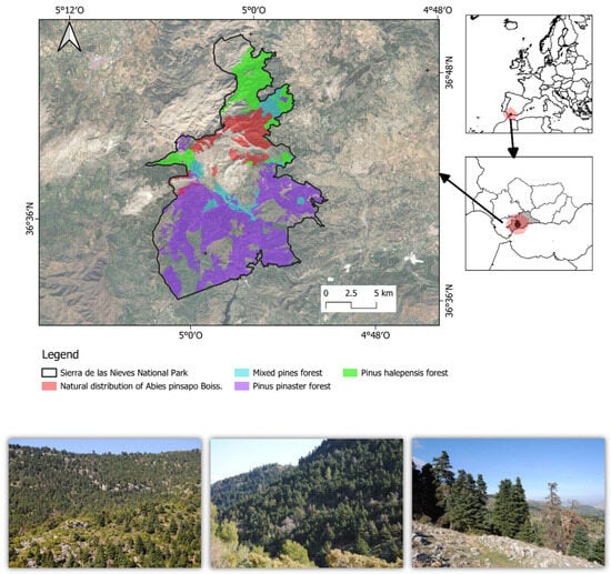
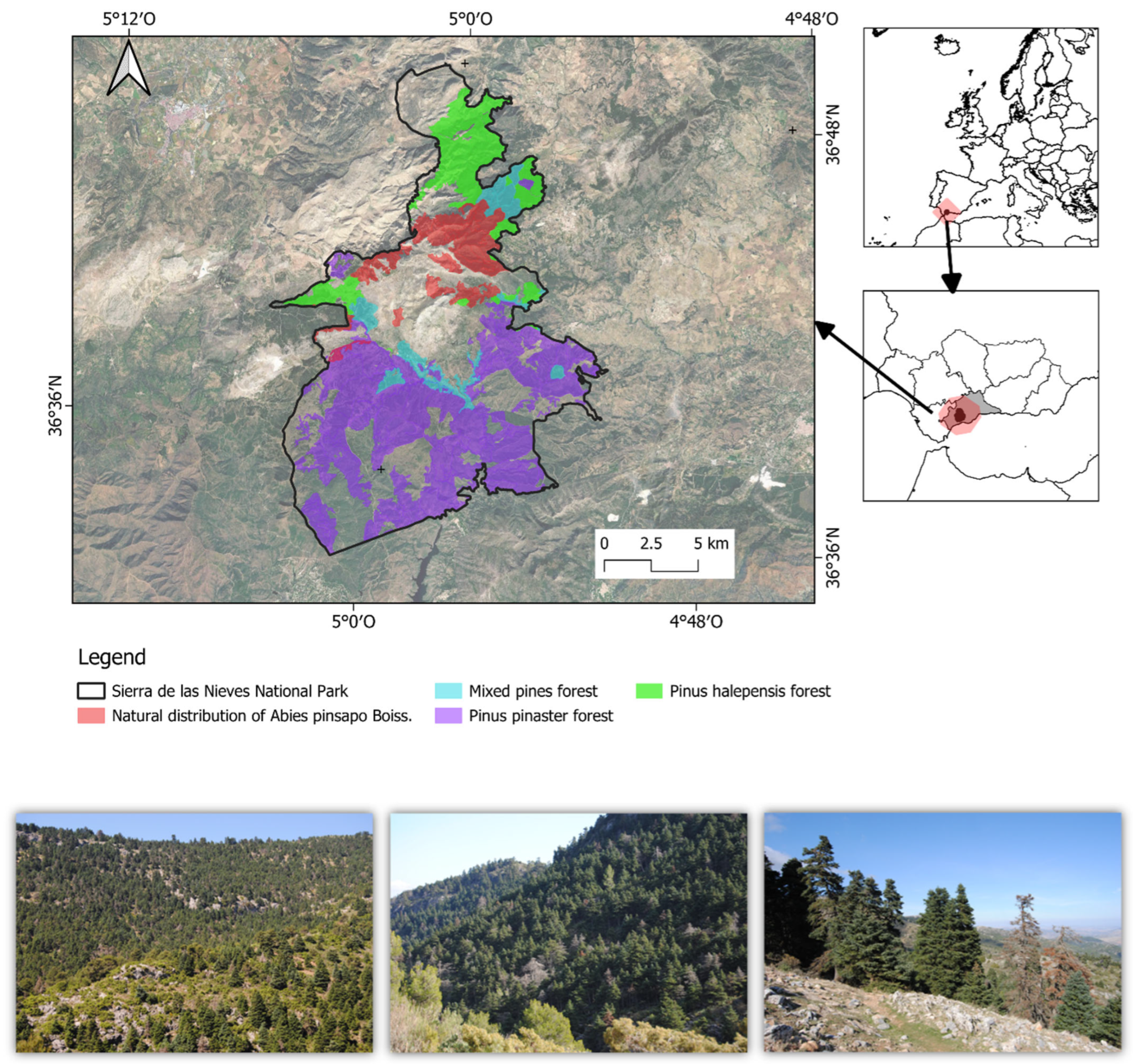
The study area is situated in the southern part of Andalusia, Spain, encompassing the National and Natural Parks of Sierra de las Nieves (Figure 1), which cover the mountain ranges that host the natural distribution of Abies pinsapo Boiss. in the Iberian Peninsula. The Sierra de las Nieves declared a Natural Park in 1989, a UNESCO Biosphere Reserve in 1995, and upgraded to National Park status in 2021, containing the most extensive and best-preserved A. pinsapo stands. The climate is typically Mediterranean, with a marked summer drought extending into early autumn and precipitation concentrated in winter and spring. Annual rainfall varies between 600 and 1600 mm depending on elevation and exposure, while mean annual temperatures range from 8 °C at the highest altitudes to around 18 °C in the foothills. Summers are warm but moderated by elevation, with August maximum daily temperatures between 29 °C and 33 °C. Soils are predominantly calcareous in Sierra de las Nieves. Vegetation here is highly diverse, ranging from fir forests on north-facing slopes and shaded ravines to holm oak (Quercus ilex subsp. ballota) and Portuguese oak (Quercus faginea) woodlands. Open areas at lower elevations are dominated by Mediterranean scrub, including Erica arborea, Pistacia lentiscus, and Rosmarinus officinalis, while higher ridges and rocky areas support juniper woodlands (Juniperus oxycedrus, J. phoenicea) and grasslands with numerous endemic species. In addition to natural vegetation, large areas within and around the Sierra de las Nieves are covered by pine plantations established mainly during the mid-20th century as part of reforestation and soil protection programs. The most widespread species is Pinus pinaster, often planted on degraded slopes and Pinus halepensis at lower elevations. These plantations are generally even-aged and relatively dense, creating homogeneous stands that contrast with the structural and floristic diversity of native forests. However, they play a dual role in the landscape. On the one hand, they provide soil stabilization and partial habitat continuity; on the other hand, they can limit the natural regeneration of broadleaved species and increase vulnerability to wildfires. In recent decades, management strategies have shifted toward promoting mixed stands by thinning plantations and encouraging the natural colonization of oaks (Quercus ilex, Q. faginea), A. pinsapo, and other native species, with the long-term aim of restoring more resilient and heterogeneous forest mosaics. The juxtaposition of different geological substrates, climatic gradients, and vegetation types creates a mosaic of high ecological value, making the region a priority for biodiversity conservation, forest management, and connectivity planning.
Figure 1.
Study area and distribution of forest types within Sierra de las Nieves National Park (southern Spain) (upper panel). The inset maps show the location of the study area in Europe and within Andalusia, southern Spain. The main map depicts the boundaries of Sierra de las Nieves National Park (black outline) and the spatial distribution of the main forest types within the park, including the natural distribution of Abies pinsapo Boiss. (red). Representative views of Abies pinsapo forests in Sierra de las Nieves National Park. Photographs show characteristic stands and landscape settings occupied by Abies pinsapo within its natural distribution range (bottom panel).
Plantations of Pinus pinaster and Pinus halepensis are usually even-aged, although structural characteristics differ between the two species due to growth rates, site conditions, and density management (Table S1 Supplementary Materials).
2.2. Methodological Framework
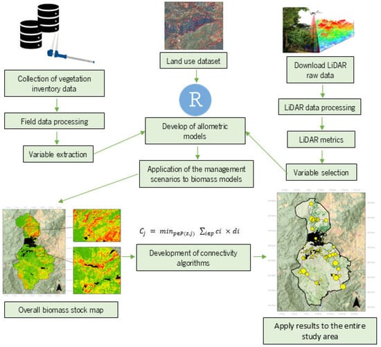
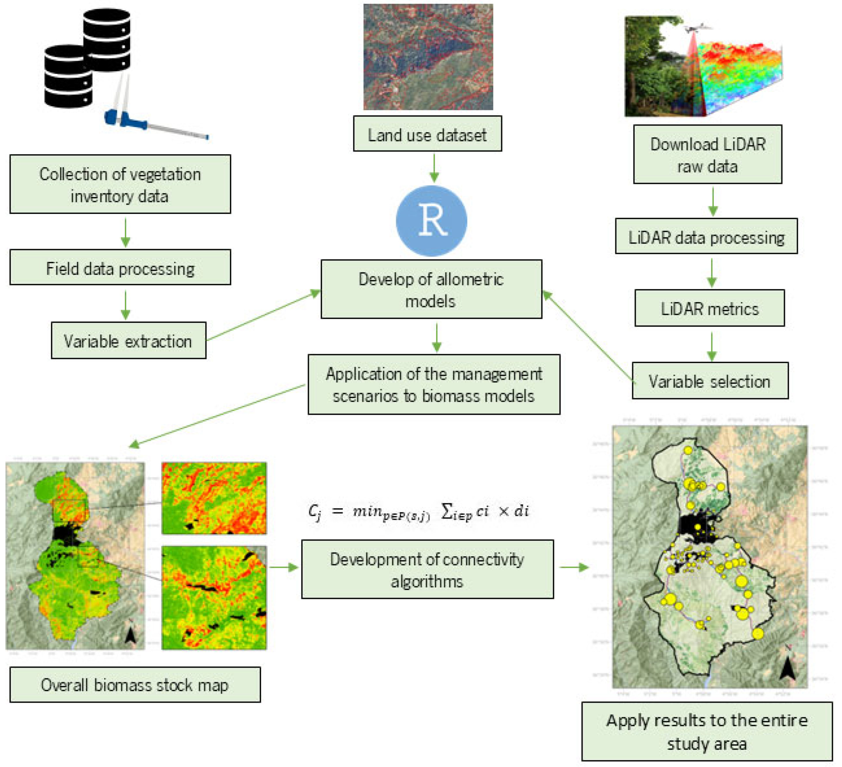
Our study used several data sets and required the development of remote sensing predictors and data analysis procedures. A flowchart outlining the steps and relationships of each process is provided in Figure 2.
Figure 2.
Flowchart used to analyze the effects of silvicultural practices on the functional connectivity of Abies pinsapo forests at Sierra de las Nieves National Park.
2.3. Data Collection
2.3.1. Land Use Dataset
Land use data was acquired from the SIPNA Map of Andalusia (SIPNA) at scale of 1:10,000 and minimum map unit of 0.1 ha (Andalusia Regional Government, http://www.juntadeandalucia.es/medioambiente/site/rediam, accessed on 3 October 2024) for the year 2021 (henceforth, SIPNA 2021). SIPNA map includes 44 land cover classes, grouped in a three-level hierarchy. Level 3 is composed of 44 land use classes. In this research, and for generalization purposes, the SIPNA classes were reclassified into eight classes: Pinus plantations, Abies forests, shrubs and non-forests uses.
2.3.2. Biomass
Dasometric data from the inventories conducted for the management of public forests present in both the Sierra de las Nieves National Park and the Natural Park, as well as in the surrounding Protection Zone, were updated following previously published growth equations [30]. To ensure the consistency and robustness of the statistical models, tree diameter and height were updated to the flight date of the first LiDAR-PNOA coverage in the area (2014) using the following Equations (1)–(3):
where _ is the diameter at breast height of tree i in cm, is the density i in trees/ha, is the competition index, is the height of tree i (m), is the age of tree i, and are coefficients that depend on the species and the site index. This site index was acquired in raster format from the REDIAM data server (https://portalrediam.cica.es/descargas/index.php/s/descargas?dir=/10_SISTEMAS_PRODUCTIVOS/03_RECURSOS_FORESTALES/Biomasa_F_And_explotacion/InfGeografica/InfRaster/TIFF/Param_Dendro accessed on 3 October 2024). The [3] is defined as a distance-independent competition index that considers all individuals of diameter class i of the same species present in the plot as competitors, including all other individuals of other species.
where and are the mean normal diameter (m) and total density (trees/ha) of other species present in the plot, while and are the diameter and density corresponding to the diameter class j, of the analyzed species, where j is different from i, and is the total number of diameter classes.
Once dasometric variables were updated, biomass load was calculated for both tree and shrub layers, using allometric equations [31,32,33,34]. Total biomass per plot was obtained by adding the biomass of individual trees and shrub strata.
Models for biomass (Mg ha−1) were developed using LiDAR. Data from two sources were used: a LiDAR-PNOA flight for the first coverage (2014), and for the second (2020), data was downloaded through the National Geographic Information Center (CNIG) via its download center (https://centrodedescargas.cnig.es/CentroDescargas/index.jsp accessed on 3 October 2024). From the normalized point cloud, height and intensity metrics and statistics were extracted from the 2014 data matching the field plots. These metrics were calculated with R software (v4.3.2; [35]), using the lidR library (version 4.1.1). Before developing the models, the best explanatory variables were selected. First, a variance inflation factor (VIF) analysis was performed to assess multicollinearity and select the best explanatory variables, considering VIF ≥ 10 as the phase-out threshold. Random Forest models were selected. To validate the model estimates, the input data were separated into training and evaluation sets, covering 70% and 30% of the input data, respectively. The performance of the model was evaluated using the metrics of root mean square error (RMSE), the correlation coefficient (R2), and the correlation between the predicted value and the observed value in the field (r). To generate the resulting biomass raster map, model was applied to the second LiDAR-PNOA coverage, updating biomass values to 2020 at a spatial resolution of 20 m.
2.4. Forest Management Scenarios
Three forest management scenarios were generated, as suggested by Ameztegui et al. (2022) [36]. These were projected onto a specific forest management plan (detailing the age of each intervention, and the type-regeneration, improvement, and weight of each one, as detailed in López et al. (2008) [37] and Navarro-Cerrillo et al. (2023) [38]. The three silvicultural scenarios were designed to represent alternative management intensities applied to the existing pine plantations surrounding remnant Abies pinsapo populations. The first scenario, named “low intervention”, foresees short rotations (80 years) and “occasional” thinning actions, promoting the use of wood as biomass (S1). This S1 corresponded to the current management framework implemented in the study area and was therefore used as the baseline condition for comparison. It should not be interpreted as a no-management scenario, but rather as a low-intervention strategy characterized by maintenance-oriented silvicultural treatments. The second scenario (S2), named “traditional silviculture”, seeks the promotion of long-lasting and useful products (structural wood, furniture), which implies extending rotations over 100 years and implementing a selective thinning regime intensity (~30% of basal area). The third scenario (S3), “reduction of climate vulnerability”, seeks to improve the adaptation of the forests to expected future water scarcity by means of early and heavy thinning (~50% of basal area). As mentioned above, the vegetation in the buffer areas of the three national parks is dominated by pine forest plantations. In these forest types, a transition toward mixed-species and uneven-aged forests would help respond to one of the main challenges confronted by forest management: developing climate-smart forestry that contributes to the mitigation of and adaptation to global change [39]. Therefore, we applied the three forest management scenarios only to stands composed of pine forest plantations. Scenarios were applied by using a percentage reduction to total biomass.
2.5. Connectivity
Connectivity was assessed within a landscape resistance framework in which biomass was used as a proxy for the structural resistance imposed by the vegetation matrix (e.g., seed dispersal, gene flow [12]). This is modeled as a Rivas et al. 2024a, 2024b [40,41] function of the cost of traversing different land-cover types. In the study area, dense pine plantations are typically characterized by homogeneous stand structures, high canopy closure, reduced understory development, and limited regeneration opportunities for Abies pinsapo. Consequently, high biomass values were interpreted as areas of greater structural resistance, whereas biomass reduction resulting from silvicultural treatments was assumed to increase structural heterogeneity, canopy openness, and habitat permeability [12]. Therefore, biomass was not intended to represent dispersal probability directly, but rather the degree of structural resistance imposed by the plantation matrix to potential ecological connectivity among A. pinsapo populations [12].
Two complementary approaches were applied in ArcGIS Pro 3.5 (Esri Inc., Redlands, CA, USA) [42]: (i) accumulated cost analysis, to characterize spatial variation in movement difficulty, and (ii) least-cost path analysis, to delineate efficient routes connecting fragmented A. pinsapo populations.
2.5.1. Accumulated Cost Analysis
The first step consisted of a cost-distance analysis [43,44] using the biomass raster as a resistance surface. Let the landscape be represented as a raster grid of cells ii, each assigned a cost value ci (per-unit distance cost). The cumulative cost Cj to reach a given destination cell j from the nearest source cell ss is defined as (Equation (4)):
where P (s, j) is the set of all possible paths between source ss and cell j, and di is the distance traversed within cell ii (usually the raster resolution or a weighted diagonal distance). This formulation ensures that the minimum cumulative cost is retained for each destination cell, producing a continuous surface of movement difficulty.
The resulting accumulated cost raster highlights zones where dispersal is more restricted, thereby identifying potential barriers and areas where targeted silvicultural interventions (e.g., thinning) may improve habitat connectivity.
2.5.2. Least-Cost Path Analysis
To complement the accumulated cost analysis [17,45], least-cost paths (LCPs) were computed between A. pinsapo populations, treated as habitat nodes. For each pair of populations aa and bb, the least-cost path is defined as (Equation (5))
This identifies the unique path (or set of paths) minimizing cumulative resistance across the landscape. The comparison of LCPs under different silvicultural management scenarios allows quantifying changes in connectivity cost and detecting shifts in optimal corridor placement. By contrasting current conditions with alternative management scenarios, we assessed the relative effectiveness of interventions in maintaining or enhancing landscape connectivity. This approach integrates ecological theory with spatially explicit decision-making, providing a robust framework for evaluating the role of silvicultural practices in conservation planning.
Accumulated cost (Cj) and LCP were performed using ArcGIS Pro (ESRI Inc., Redlands, CA, USA). The biomass raster was used as the resistance surface and processed using an eight-neighbor connectivity scheme. Cost-distance calculations were implemented under an isotropic resistance framework, assuming equal movement costs in all directions.
3. Results
3.1. Biomass Distribution Under Forest Management Scenarios
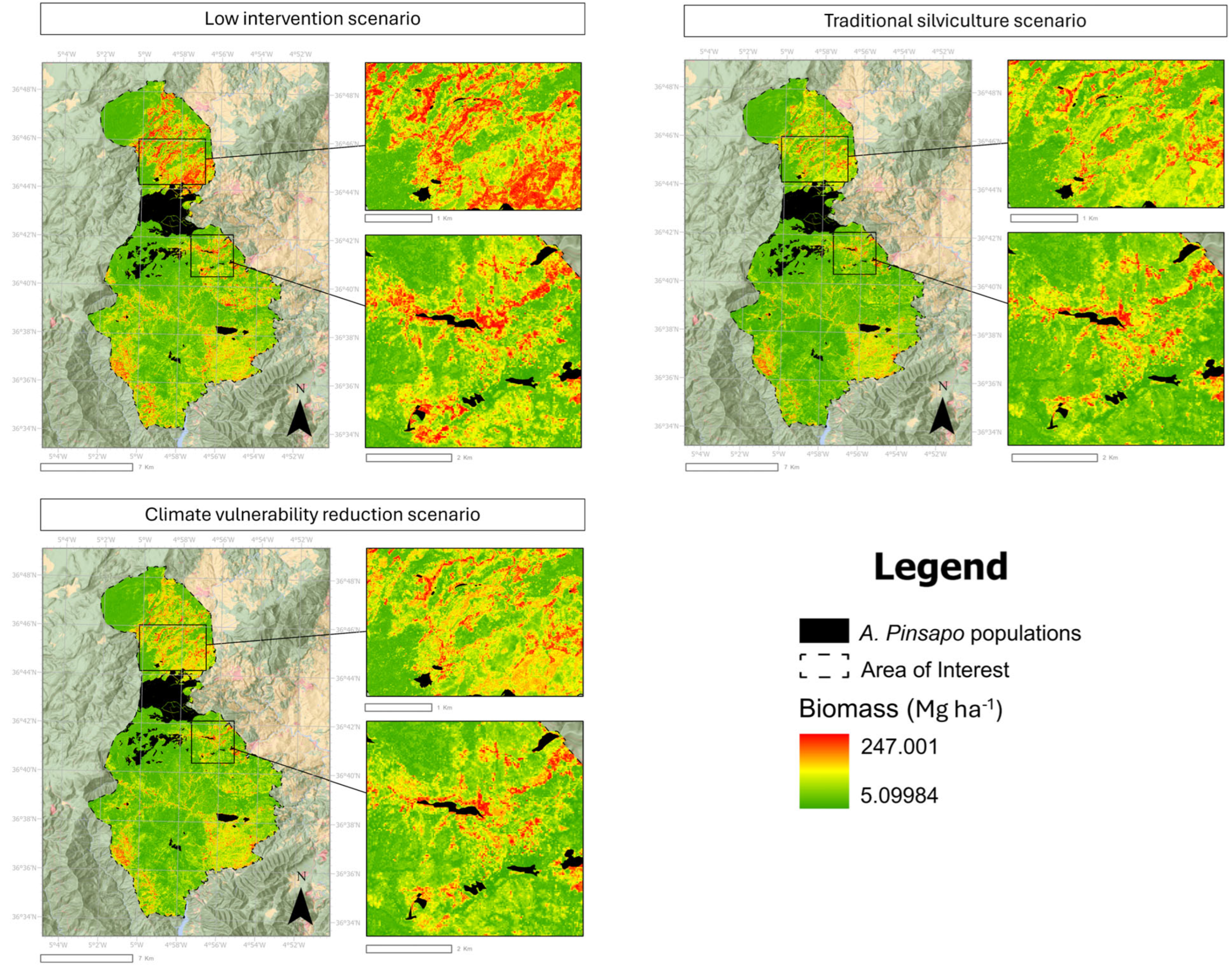
The application of the three forest management scenarios revealed significant contrasts in the spatial distribution of biomass within the analyzed pine stands (Figure 3). In the low intervention scenario (top left), characterized by short rotations and occasional thinning, a greater accumulation of biomass was observed, with a predominance of high values (red areas). This trend reflects the low intensity of silvicultural interventions and the consequent accumulation of woody material available for energy uses.
Figure 3.
Spatial distribution of aboveground biomass (Mg ha−1) under the three forest management scenarios evaluated for A. pinsapo populations. Biomass values are represented on a continuous gradient from low (green) to high (red) biomass. Insets highlight representative areas where differences among management strategies are more evident. All maps are displayed using the same biomass scale to facilitate direct visual comparison among scenarios.
The traditional silviculture scenario (top right), which promotes long-lasting products through extended rotations and a moderate thinning regime (~30% of basal area), showed a more balanced distribution, with a predominance of intermediate biomass values (yellow and green areas). This indicates a partial reduction in stand density compared to the previous scenario, while maintaining sufficient stock for high-quality timber.
Finally, the climate vulnerability reduction scenario (bottom left), based on early and heavy thinning (~50% of basal area), resulted in a marked decrease in accumulated biomass, as evidenced by the predominance of green areas. Although this strategy reduces the total volume, it may reduce water competition and create conditions that are generally considered more favorable for adaptation to future water scarcity.
3.2. Accumulated Cost
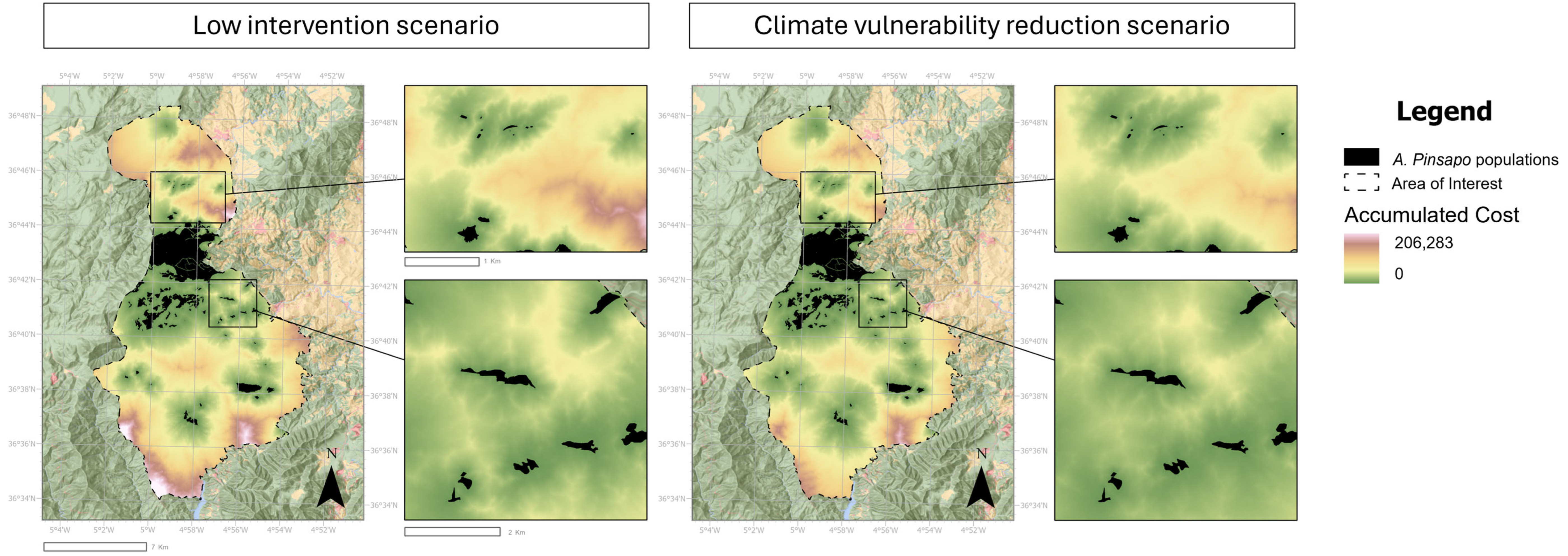
Figure 4 illustrates the spatial distribution of accumulated cost for Abies pinsapo connectivity under two conditions: in the low intervention scenario (left) and the climate vulnerability reduction scenario (right). In the low intervention scenario, the cost surface showed extensive areas of medium-to-high resistance (yellow to red), particularly in the southern and central sectors of the study area. These zones corresponded to landscapes with lower forest biomass or discontinuous vegetation, which act as barriers to dispersal. Low-cost areas (green) were mainly concentrated around the existing A. pinsapo stands in the northern massif, creating localized connectivity but limited long-distance linkages across the broader landscape.
Figure 4.
Spatial distribution of accumulated cost-distance under the low-intervention and climate-vulnerability reduction scenarios. Accumulated cost values are represented on a continuous color gradient ranging from low values (green) to high values (white), with intermediate values shown in yellow, pink, and purple tones. Insets highlight representative areas where differences between scenarios are more evident. A. pinsapo populations are shown in black. All maps are displayed using the same cost-distance scale to facilitate direct visual comparison between management scenarios.
In the climate vulnerability reduction scenario, cost values were noticeably reduced across much of the study area. The improvement is especially evident in the central and southern sectors, where previously high-resistance zones shift towards lower-cost values (green shades). This indicates that silvicultural interventions according to the resistance assumptions adopted in the connectivity model between isolated A. pinsapo populations.
3.3. Least-Cost Paths
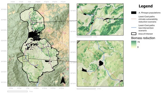
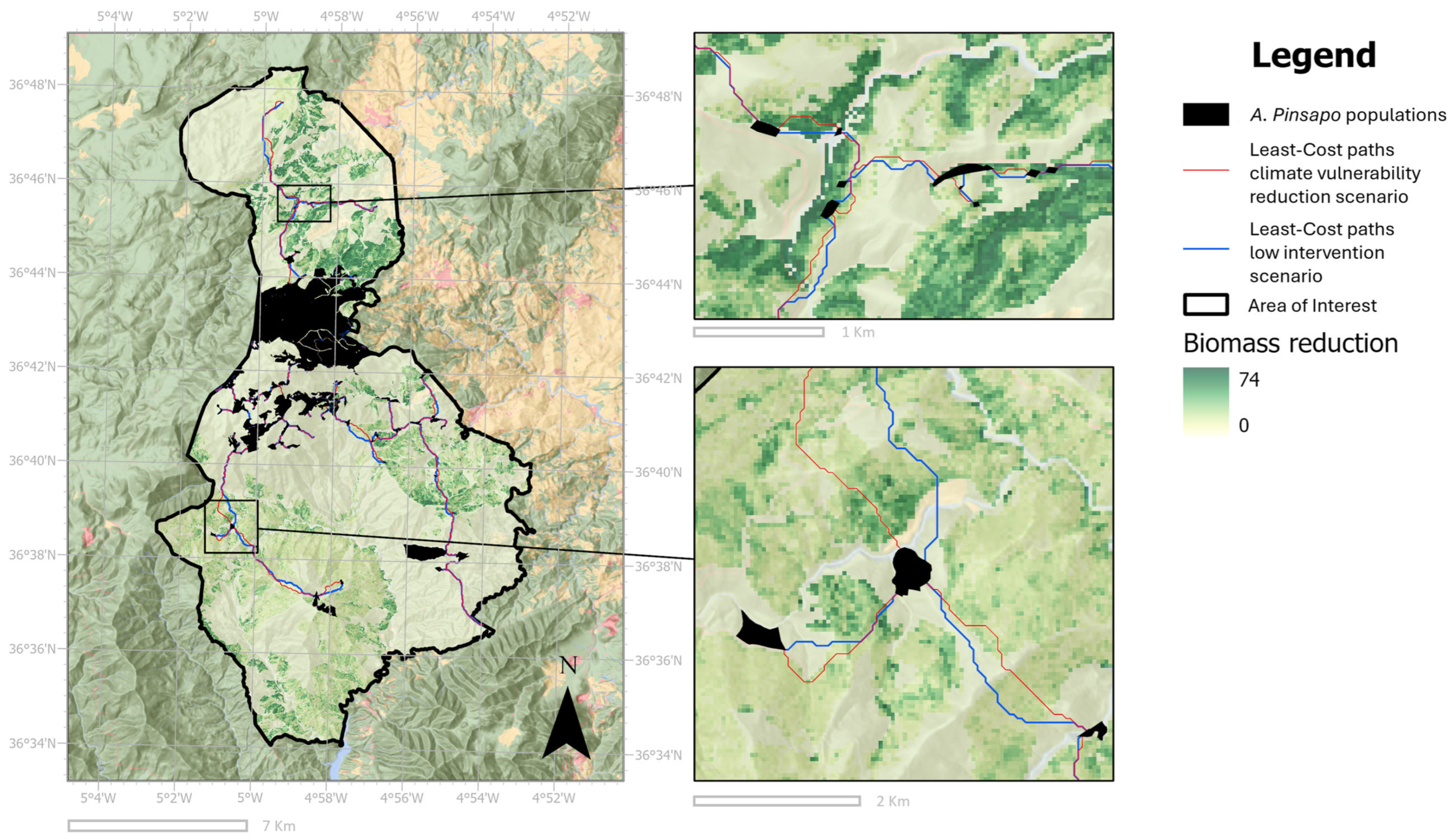
Figure 5 shows the least-cost paths (LCPs) linking Abies pinsapo populations under two conditions: in the low intervention scenario (blue paths) and the climate vulnerability reduction scenario (red paths). Under both scenarios, some routes remain relatively similar; however, in other cases, the least-cost paths show notable variations because of biomass reduction. Lower structural resistance values decrease landscape resistance, thereby facilitating dispersal and enabling new or alternative routes to emerge. This effect is particularly evident in areas where silvicultural interventions were applied, as the reduction in biomass not only alters local cost surfaces but also reshapes the broader spatial configuration of connectivity. As a result, least-cost paths are redirected through zones where resistance has been reduced, creating novel routes between patches (Figure 5, detailed images).
Figure 5.
Least-cost paths connecting Abies pinsapo populations under the low-intervention scenario (blue) and the climate-vulnerability reduction scenario (red). A. pinsapo populations are shown in black. The background raster represents the spatial distribution of biomass reduction between scenarios, calculated as biomass under the traditional silviculture scenario minus biomass under the climate-vulnerability reduction scenario. Darker green tones indicate greater biomass reduction. Insets highlight representative areas where differences in least-cost path location between scenarios are more evident.
The results indicate that the average cost decreased by 18.31%, while the median decreased by 2.92% (Table 1). Additionally, this comparison among scenarios confirmed the patterns observed in the accumulated cost maps. The standard deviation decreased −15.47%, indicating a reduction in the spatial variability of resistance values across the landscape. The cost gradually increases toward the edges of the study area, with the most distant populations showing lower connectivity and higher accumulated costs. The reduction between the low-intervention and silvicultural scenarios can reach up to 60% of the cost required to connect a population with its neighbors, with the areas where silviculture has been applied showing the most pronounced decrease (Figure 4).
Table 1.
Mean, median and standard deviation (S.D.) of the distances in cost for low intervention scenario (S1), traditional silviculture (S2), and the climate vulnerability reduction scenario (S3), with variation (Δ) between low intervention and climate vulnerability reduction scenario.
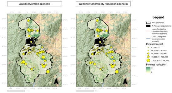
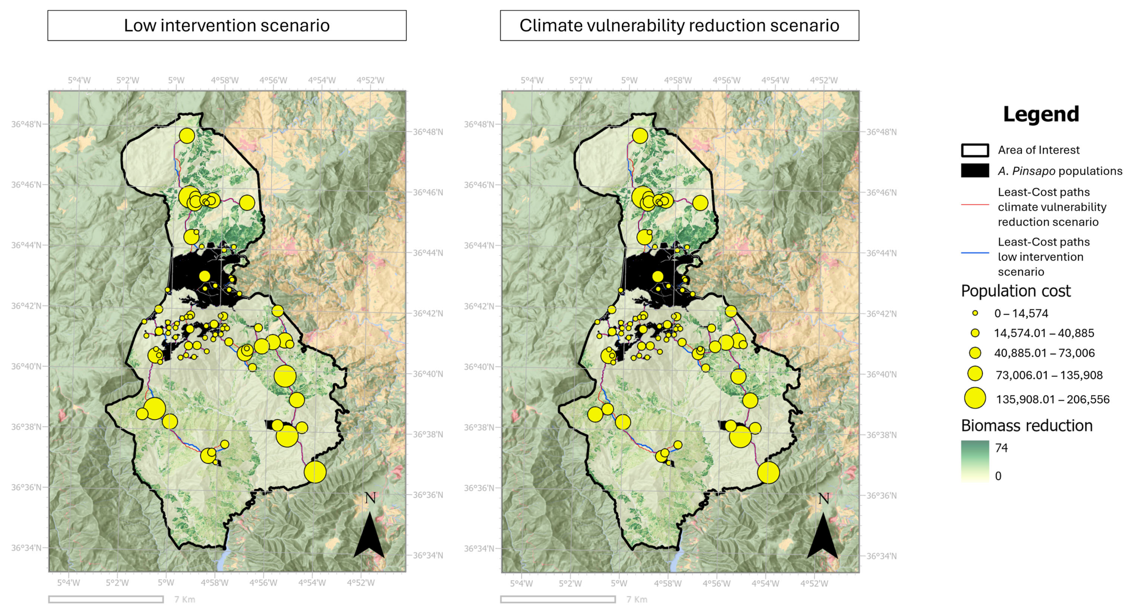
Figure 6 shows the spatial distribution of connectivity costs for Abies pinsapo populations under the low intervention scenario (left) and the climate vulnerability reduction scenario (right), and illustrates that a large number of populations exhibit relatively low connectivity costs, as indicated by smaller circles, with the central region of the study area hosting the majority of populations with minimal resistance. In contrast, populations located in peripheral or more distant areas are represented by larger circles, reflecting higher connectivity costs and greater landscape resistance in these zones. Under the climate vulnerability reduction scenario, which involves biomass reduction through silvicultural interventions, connectivity costs decrease across the landscape. This effect is particularly pronounced in areas adjacent to the applied management treatments, where reductions in biomass lower resistance values and facilitate dispersal. As a result, previously large circles become smaller, indicating improved connectivity.
Figure 6.
Population cost and least-cost paths under the low-intervention scenario (left) and the climate-vulnerability reduction scenario (right). Circle size represents the cumulative cost associated with routes connecting Abies pinsapo populations, with larger circles indicating higher costs. Blue and red lines represent least-cost paths under the low-intervention and climate-vulnerability reduction scenarios, respectively. The background raster shows biomass reduction, calculated as biomass under the traditional silviculture scenario minus biomass under the climate-vulnerability reduction scenario, with darker green tones indicating greater reductions.
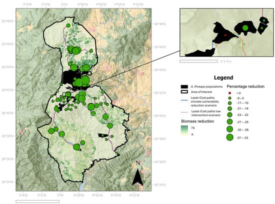
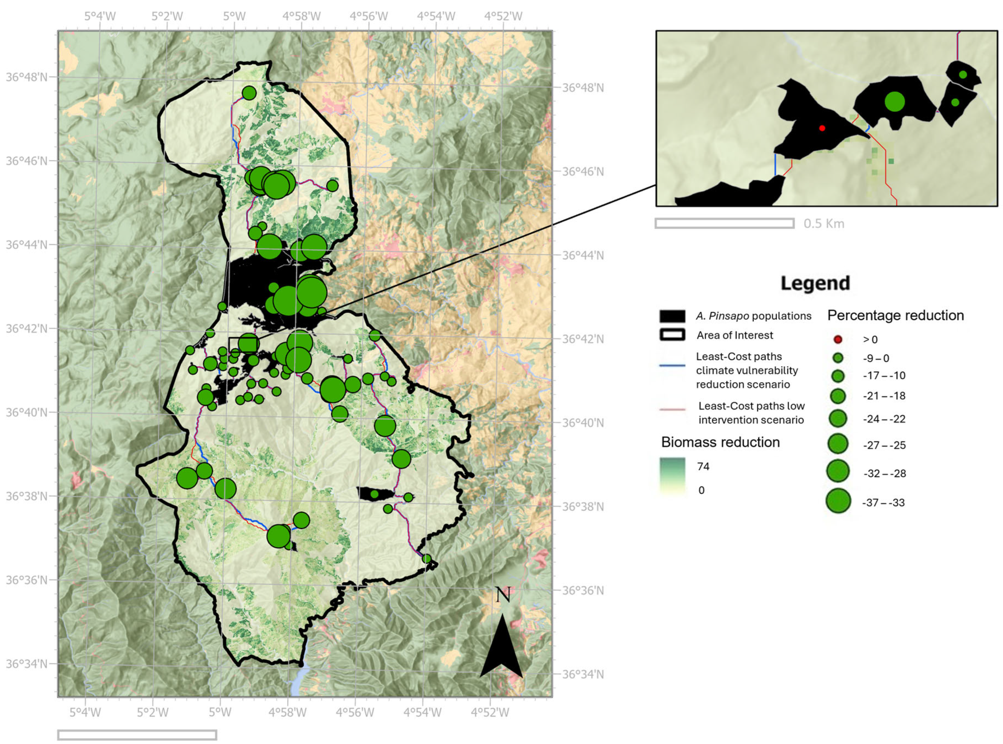
Figure 7 presents the percentage reduction in accumulated connectivity costs among Abies pinsapo populations when comparing the low intervention scenario with the climate vulnerability reduction scenario. The results show a substantial decrease in movement costs across most of the network, confirming that silvicultural management enhances functional connectivity.
Figure 7.
Percentage reduction in accumulated cost between the climate-vulnerability reduction and low-intervention scenarios for populations connected by least-cost paths. Circle size is proportional to the magnitude of the accumulated cost reduction, with larger circles indicating greater decreases in cost. Negative values indicate lower accumulated costs under the climate-vulnerability reduction scenario relative to the low-intervention scenario. The background raster represents biomass reduction, while black polygons indicate Abies pinsapo populations. Where: (Δ = (Cost in climate vulnerability reduction scenario-Cost in low intervention scenario)/Cost in low intervention scenario × 100).
The greatest reductions were observed in the central and northern sectors, where large circles highlight populations that benefit most from improved biomass conditions; these populations exhibit connectivity cost reductions greater than 36%. These areas correspond to zones that previously exhibited medium resistance but are strongly alleviated under the management scenario, allowing for the formation of more efficient corridors.
In the southern and peripheral populations, reductions are smaller but still consistent, suggesting that management interventions have positive, though more localized, effects in these drier and more fragmented landscapes. Notably, all populations except one show some degree of cost reduction, indicating that the benefits of management extend across the entire network rather than being concentrated in a single area. The population with the highest cost (Figure 7, detailed view) reflects the creation of a new, more efficient pathway due to silvicultural management, which establishes an alternative route that optimizes connectivity among all patches.
The silvicultural scenario not only reduces overall connectivity costs but also balances the distribution of connectivity among populations, decreasing isolation for both central and peripheral nuclei. This demonstrates that management interventions can substantially mitigate landscape resistance, thereby enhancing the robustness and resilience of the connectivity network for A. pinsapo.
4. Discussion
One of the most outstanding plant species of the Iberian Peninsula is the Spanish fir, Abies pinsapo a tertiary relict species endemic to SW Spain [46]. Considered one of the most threatened and emblematic species in the country, its population is continuously declining [47], with only five populations estimated to remain worldwide [48]. Although habitat fragmentation can sometimes offer protection against recurrent wildfires, it also compromises the long-term viability of these populations due to the lack of connectivity [49]. The prolonged isolation of populations has resulted in reduced or nonexistent gene flow among some of them [50].
The results of this study provide new insights into the role of silvicultural practices in enhancing connectivity among Abies pinsapo populations in the Sierra de las Nieves and surrounding ranges. By combining cost-distance and least-cost path analyses under current and alternative management scenarios, we show that targeted interventions aimed at decrease biomass and structural complexity substantially reduce landscape resistance, thereby improving functional connectivity. These findings highlight the potential of adaptive silvicultural management as a key tool in the conservation of A. pinsapo, a relict Mediterranean fir of high ecological and biogeographical importance.
4.1. Effects of Silvicultural Interventions
The effects of silvicultural interventions on A. pinsapo populations are twofold. First, by reducing biomass density in the forest, the establishment of new seeds is facilitated through decreased competition and enhanced germination [51,52], potentially leading to the formation of new populations that serve as ecological connectors between existing ones. Furthermore, biomass reduction not only improves germination but also promotes seed dispersal; being anemochorous, seeds can travel greater distances without obstacles impeding their movement [53].
The implementation of the silvicultural scenario markedly improved connectivity across the study area. Accumulated costs decreased substantially, as evidenced by the widespread reduction in circle sizes across populations, with the strongest improvements observed in central and northern regions (Figure 7). Least-cost path analysis further demonstrated that silvicultural interventions not only reduce the resistance of existing corridors but also create alternative routes, facilitating connectivity (Figure 5 and Table 1).
These results illustrate how forest management can directly influence landscape-scale processes. By increasing forest biomass through thinning, stand diversification, and promotion of natural regeneration, silvicultural practices enhance structural continuity and canopy cover, thereby reducing resistance to dispersal. Compared with previous connectivity studies in Mediterranean forests [14,28], our results indicate a relatively strong response of landscape permeability to restoration-oriented silvicultural treatments. Whereas most previous studies for Mediterranean forests have primarily identified connectivity constraints or mapped potential corridors under current landscape conditions [54], our scenario-based approach explicitly quantifies the relative improvement achieved through alternative management strategies. These findings reinforce previous evidence while highlighting the value of integrating connectivity modelling with practical silvicultural planning [55].
However, results suggest that intensive thinning may temporarily alter local microclimatic conditions by increasing solar radiation, air temperature, and evaporative demand at the forest floor [55]. Similarly, reductions in canopy cover may increase soil exposure and susceptibility to erosion, particularly on steep slopes typical of Mediterranean mountain landscapes, and also modify understory composition and facilitate the establishment of opportunistic or disturbance-adapted species [55]. Consequently, thinning treatments should be implemented within an adaptive management framework that balances connectivity benefits with potential short-term ecological impacts and incorporates long-term monitoring of vegetation responses.
4.2. Connectivity of Abies pinsapo Under Current Conditions
The connectivity improvements observed under the alternative silvicultural scenarios are consistent with recent studies emphasizing the role of forest management in enhancing landscape permeability and supporting the long-term adaptive capacity of fragmented forest ecosystems. Although connectivity alone cannot guarantee population persistence, reducing structural barriers within the landscape may create more favorable conditions for ecological processes associated with conservation and restoration under ongoing environmental change.
Under present biomass distributions, connectivity between the A. pinsapo nuclei is strongly constrained by high-resistance areas, particularly in the southern and central parts of the study area. The cost-distance analysis revealed that populations in these sectors are associated with higher accumulated costs, reflecting both lower structural resistance and the prevalence of open or degraded habitats. As a result, least-cost paths are short and clustered around the northern massif, while long-distance linkages toward more isolated populations remain costly and limited. Such patterns are consistent with previous studies emphasizing the vulnerability of A. pinsapo to habitat fragmentation and climate stress [56,57].
Fragmentation of A. pinsapo forests is not only a historical outcome of land use change but also exacerbated by contemporary disturbances such as fire, drought, and pest outbreaks [58]. The isolation of marginal populations can reduce gene flow, increase in- breeding, and compromise long-term adaptive capacity [12,55]. Our results confirm that under current conditions, functional connectivity is highly uneven, with central populations acting as hubs while peripheral ones remain poorly connected. However, the connectivity improvements identified here should be interpreted as changes in landscape permeability under alternative management scenarios rather than as direct evidence of increased climate resilience. Demonstrating enhanced resilience would require integrating connectivity analyses with climate suitability projections, demographic models, regeneration dynamics, and long-term monitoring of population responses [55,56].
4.3. Implications for Conservation and Forest Management
The conservation of A. pinsapo requires not only the protection of existing stands but also the maintenance of ecological processes that ensure their long-term viability. Our results demonstrate that silvicultural management can play a pivotal role in this regard by enhancing habitat connectivity. Improved connectivity facilitates seed dispersal, colonization of suitable sites, and gene flow between fragmented stands, all of which are essential to buffer the species against environmental change.
Connectivity also enhances the capacity of forests to respond to climate change. Mediterranean firs are highly sensitive to increasing temperatures and prolonged droughts, which threaten their survival at lower elevations [59]. By improving connectivity, management can allow populations to track suitable habitats along elevational and microclimatic gradients, thereby reducing the risk of local extinction. This aligns with broader conservation strategies emphasizing the creation of ecological networks to support species persistence under changing climates [15,60].
From a practical standpoint, our findings suggest that management actions should prioritize areas of currently high resistance that act as barriers between populations. Interventions in these areas (e.g., reducing pine plantation density, facilitating oak and fir regeneration, and enhancing structural diversity) would yield disproportionate benefits in terms of connectivity. From a practical management perspective, the results suggest that restoration efforts should be prioritized in the central sectors of Sierra de las Nieves, where silvicultural interventions produced the largest reductions in accumulated connectivity costs. These areas currently function as high-resistance zones separating several of the main Abies pinsapo nuclei and therefore represent strategic locations for improving landscape permeability. In these areas, thinning treatments generated substantial reductions in modeled resistance and promoted the emergence of more efficient least-cost pathways. Consequently, rather than applying silvicultural treatments uniformly across the landscape, management efforts should focus on those sectors where reductions in structural resistance are most likely to improve connectivity between currently fragmented populations [49,61].
Moreover, silvicultural strategies should be integrated with broader landscape-scale planning. The Sierra de las Nieves National Park already serves as biodiversity reservoirs, but functional connectivity between them and adjacent areas is not guaranteed. Our results support the establishment of management corridors that link these protected areas, in line with the principles of the EU Habitats Directive and the Natura 2000 network [62].
Moreover, the connectivity calculations show us the most isolated populations, as well as the paths or routes to connect populations. These areas can be used to promote reforestation efforts, which would allow the creation of new populations that act as steppingstones, increasing connectivity and reducing isolation [63,64].
4.4. Limitations and Future Research
While the modelling framework applied here provides valuable insights, it is subject to certain limitations. First, the assumption of biomass as a resistance variable represents a simplification of the ecological processes governing connectivity. Although vegetation structure influences habitat permeability and regeneration dynamics, other factors such as microclimatic conditions, topographic complexity, soil properties, disturbance history, and species-specific dispersal mechanisms may also affect connectivity patterns. Future studies should incorporate these variables to develop more comprehensive resistance surfaces and evaluate their relative contribution to connectivity outcomes. We acknowledge that connectivity improvements observed under the alternative management scenarios are partly influenced by the resistance assumptions adopted in the model. Therefore, results should be interpreted as comparative assessments of relative changes in landscape permeability rather than as direct predictions of future dispersal dynamics. The strength of the approach lies in its ability to evaluate the relative effectiveness of alternative management strategies under a consistent ecological framework. Other factors, such as microclimate, soil type, and disturbance regimes, also influence dispersal and connectivity and should be incorporated in future models. Second, our analysis assumes uniform dispersal capacities across populations, whereas A. pinsapo dispersal is likely to be spatially heterogeneous due to topography and local environmental conditions.
An additional limitation of this study relates to the assumptions underlying the resistance surface and the connectivity modelling framework. Biomass was used as a proxy for structural resistance because the primary objective was to evaluate the potential effects of alternative silvicultural interventions on landscape permeability. Although this approach provides a consistent basis for comparing management scenarios, other environmental factors, including microclimatic conditions, soil properties, topographic complexity, disturbance history, and species-specific dispersal mechanisms, may also influence connectivity patterns. Furthermore, the resistance model was based on a single resistance formulation, and no formal sensitivity analysis was performed to evaluate the influence of alternative resistance surfaces on connectivity outcomes. Consequently, the results should be interpreted as comparative assessments of relative changes among management scenarios rather than as absolute predictions of dispersal dynamics or population responses. Future studies should incorporate uncertainty and sensitivity analyses to assess the robustness of connectivity indicators under alternative ecological assumptions and modelling approaches.
Future research should combine resistance-based modelling with empirical data on genetic connectivity and demographic processes to validate model predictions. The integration of circuit theory approaches [65] could also provide complementary insights into multiple-path connectivity and redundancy. Finally, long-term monitoring of management interventions would be critical to assess whether predicted improvements in connectivity translate into measurable conservation outcomes.
5. Conclusions
This study shows that silvicultural management can play a decisive role in enhancing functional connectivity among Abies pinsapo populations in southern Spain. By integrating biomass-based resistance surfaces with cost-distance and least-cost path analyses, we provide robust evidence that targeted interventions—particularly those involving intensive thinning—substantially reduce landscape resistance and facilitate ecological flows across fragmented forest systems. The results consistently show that connectivity improvements are not limited to isolated areas but occur across the entire network. Reductions in accumulated cost, alongside the emergence of shorter and alternative least-cost paths, indicate that silvicultural treatments can effectively reconfigure landscape permeability. These improvements were concentrated in central high-resistance sectors of Sª de Las Nieves National Park, suggesting that restoration-oriented silvicultural interventions should prioritize these areas. This is particularly relevant in previously high-resistance zones, where management actions lead to disproportionately large gains in connectivity. Importantly, these benefits extend beyond core populations, contributing to the integration of peripheral and more isolated stands, which are critical for maintaining genetic diversity and long-term adaptive capacity.
Although the model does not directly evaluate regeneration, population dynamics, or climate-change adaptation, the observed reductions in landscape resistance indicate that adaptive forest management may contribute to improving habitat permeability and supporting long-term conservation planning for this endangered Mediterranean fir.
Supplementary Materials
The following supporting information can be downloaded at: https://www.mdpi.com/article/10.3390/f17070777/s1, Table S1. Forest inventory variables for the main tree species present in the study area. Variables include tree density (Trees ha−1), basal area (G, m2 ha−1), standing volume (Vcc, m3 ha−1), and current annual increment (Iv, m3 ha−1 yr−1), mean tree height (Ht, m).
Author Contributions
Conceptualization, R.M.N.C., C.A.R. and A.J.A.-S.; Methodology, R.M.N.C., C.A.R., M.Á.V.M., A.J.A.-S. and G.P.-R.; Formal Analysis, R.M.N.C., C.A.R., M.Á.V.M. and A.J.A.-S.; Investigation, R.M.N.C. and C.A.R.; Resources, R.M.N.C. and G.P.-R.; Data Curation, R.M.N.C., C.A.R. and M.Á.V.M.; Writing—Original Draft Preparation, R.M.N.C., C.A.R., M.Á.V.M. and A.J.A.-S.; Writing—Review and Editing, all authors; Project Administration, R.M.N.C. and G.P.-R. All authors have read and agreed to the published version of the manuscript.
Funding
This research was funded by Bio+ project supported by the Biodiversity Foundation of the Ministry for the Ecological Transition and the Demographic Challenge (MITECO) of the Government of Spain, within the framework of the Recovery, Transformation and Resilience Plan (PRTR), funded by the European Union–NextGenerationEU.
Institutional Review Board Statement
Not applicable.
Informed Consent Statement
Not applicable.
Data Availability Statement
The data presented in this study is available on request from the corresponding author. The data is not publicly available due to institutional restrictions.
Acknowledgments
The authors thank the following projects: SILVADAPT.NET (RED2018-102719-T) and Biodiversity Foundation of the Ministry for the Ecological Transition and the Demographic Challenge (MITECO) of the Government of Spain, within the framework of the Recovery, Transformation and Resilience Plan (PRTR), funded by the European Union–“NextGenerationEU”. We acknowledge the institutional support of the Instituto Interuniversitario del Sistema Tierra en Andalucía, (IISTA). We thank Jorgelina Brasca for revisions of the written English in different versions of this manuscript, and the anonymous referees for their valuable comments and corrections.
Conflicts of Interest
The authors declare no conflicts of interest.
References
- Rundel, P.W. A Neogene Heritage: Conifer Distributions and Endemism in Mediterranean-Climate Ecosystems. Front. Ecol. Evol. 2019, 7, 364. [Google Scholar] [CrossRef] [Scilit]
- Linares, J.C. Biogeography and Evolution of Abies (Pinaceae) in the Mediterranean Basin: The Roles of Long-Term Climatic Change and Glacial Refugia: Biogeography and Evolution of the Circum-Mediterranean Firs. J. Biogeogr. 2011, 38, 619–630. [Google Scholar] [CrossRef] [Scilit]
- Ne’eman, G.; Osem, Y. Pines and Their Mixed Forest Ecosystems in the Mediterranean Basin; Ne’eman, G., Osem, Y., Eds.; Managing Forest Ecosystems; Springer International Publishing: Cham, Switzerland, 2021; Volume 38. [Google Scholar]
- Xiao, S.; Li, S.; Wang, X.; Chen, L.; Su, T. Cedrus Distribution Change: Past, Present, and Future. Ecol. Indic. 2022, 142, 109159. [Google Scholar] [CrossRef] [Scilit]
- Mori, A.S.; Lertzman, K.P.; Gustafsson, L. Biodiversity and Ecosystem Services in Forest Ecosystems: A Research Agenda for Applied Forest Ecology. J. Appl. Ecol. 2017, 54, 12–27. [Google Scholar] [CrossRef] [Scilit]
- Peñuelas, J.; Sardans, J. Global Change and Forest Disturbances in the Mediterranean Basin: Breakthroughs, Knowledge Gaps, and Recommendations. Forests 2021, 12, 603. [Google Scholar] [CrossRef] [Scilit]
- Anderegg, W.R.L.; Trugman, A.T.; Badgley, G.; Anderson, C.M.; Bartuska, A.; Ciais, P.; Cullenward, D.; Field, C.B.; Freeman, J.; Goetz, S.J.; et al. Climate-Driven Risks to the Climate Mitigation Potential of Forests. Science 2020, 368, eaaz7005. [Google Scholar] [CrossRef] [Scilit] [PubMed]
- Morales-Molino, C.; Steffen, M.; Samartin, S.; Van Leeuwen, J.F.N.; Hürlimann, D.; Vescovi, E.; Tinner, W. Long-Term Responses of Mediterranean Mountain Forests to Climate Change, Fire and Human Activities in the Northern Apennines (Italy). Ecosystems 2021, 24, 1361–1377. [Google Scholar] [CrossRef] [Scilit] [PubMed]
- Ruiz-Labourdette, D.; Schmitz, M.F.; Pineda, F.D. Changes in Tree Species Composition in Mediterranean Mountains under Climate Change: Indicators for Conservation Planning. Ecol. Indic. 2013, 24, 310–323. [Google Scholar] [CrossRef] [Scilit]
- Magrach, A.; Laurance, W.F.; Larrinaga, A.R.; Santamaria, L. Meta-Analysis of the Effects of Forest Fragmentation on Interspecific Interactions. Conserv. Biol. 2014, 28, 1342–1348. [Google Scholar] [CrossRef] [Scilit] [PubMed]
- Rivas, C.A.; Guerrero-Casado, J.; Navarro-Cerillo, R.M. Deforestation and Fragmentation Trends of Seasonal Dry Tropical Forest in Ecuador: Impact on Conservation. For. Ecosyst. 2021, 8, 46. [Google Scholar] [CrossRef] [Scilit]
- Kool, J.T.; Moilanen, A.; Treml, E.A. Population Connectivity: Recent Advances and New Perspectives. Landsc. Ecol. 2013, 28, 165–185. [Google Scholar] [CrossRef] [Scilit]
- Kim, E.; Song, W.; Lee, D. Forest Fragmentation and Its Impacts: A Review. J. Korea Soc. Environ. Restor. Technol. 2012, 15, 149–162. [Google Scholar] [CrossRef] [Scilit]
- Martínez-Richart, A.I.; Zolles, A.; Oettel, J.; Petermann, J.S.; Essl, F.; Lapin, K. A Review of Structural and Functional Connectivity Studies in European Forests. Landsc. Ecol. 2024, 40, 10. [Google Scholar] [CrossRef] [Scilit]
- Hilty, J.; Worboys, G.L.; Keeley, A.; Woodley, S.; Lausche, B.J.; Locke, H.; Carr, M.; Pulsford, I.; Pittock, J.; White, J.W. Guidelines for Conserving Connectivity Through Ecological Networks and Corridors; International Union for Conservation of Nature: Gland, Switzerland, 2020. [Google Scholar]
- Wang, X.; Blanchet, F.G.; Koper, N. Measuring Habitat Fragmentation: An Evaluation of Landscape Pattern Metrics. Methods Ecol. Evol. 2014, 5, 634–646. [Google Scholar] [CrossRef] [Scilit]
- Adriaensen, F.; Chardon, J.P.; De Blust, G.; Swinnen, E.; Villalba, S.; Gulinck, H.; Matthysen, E. The Application of ‘Least-Cost’ Modelling as a Functional Landscape Model. Landsc. Urban Plan. 2003, 64, 233–247. [Google Scholar] [CrossRef] [Scilit]
- Beier, P.; Majka, D.R.; Spencer, W.D. Forks in the Road: Choices in Procedures for Designing Wildland Linkages. Conserv. Biol. 2008, 22, 836–851. [Google Scholar] [CrossRef] [Scilit] [PubMed]
- Calvo, R.C.; Varo Martínez, M.Á.; Ruiz Gómez, F.; Ariza Salamanca, A.J.; Navarro-Cerrillo, R.M. Improvements of Fire Fuels Attributes Maps by Integrating Field Inventories, Low Density ALS, and Satellite Data in Complex Mediterranean Forests. Remote Sens. 2023, 15, 2023. [Google Scholar] [CrossRef] [Scilit]
- Oettel, J.; Lapin, K. Linking Forest Management and Biodiversity Indicators to Strengthen Sustainable Forest Management in Europe. Ecol. Indic. 2021, 122, 107275. [Google Scholar] [CrossRef] [Scilit]
- Carvajal, R.; Constantino, M.; Goycoolea, M.; Vielma, J.P.; Weintraub, A. Imposing Connectivity Constraints in Forest Planning Models. Oper. Res. 2013, 61, 824–836. [Google Scholar] [CrossRef] [Scilit]
- Hoffmann, J.A.; Teketay, D.; Negash, M.; Tesfay, H.M. Restoring Forest Landscape Connectivity: Why, Where, and How? In Ecological Connectivity of Forest Ecosystems; Lapin, K., Oettel, J., Braun, M., Konrad, H., Eds.; Springer Nature: Cham, Switzerland, 2025; pp. 265–295. ISBN 978-3-031-82205-6. [Google Scholar]
- Nordén, B.; Dahlberg, A.; Brandrud, T.E.; Fritz, Ö.; Ejrnaes, R.; Ovaskainen, O. Effects of Ecological Continuity on Species Richness and Composition in Forests and Woodlands: A Review. Écoscience 2014, 21, 34–45. [Google Scholar] [CrossRef] [Scilit]
- Caudullo, G.; Tinner, W. Abies-Circum-Mediterranean Firs in Europe: Distribution, Habitat, Usage and Threats. In European Atlas of Forest Tree Species; San-Miguel-Ayanz, J., de Rigo, D., Caudullo, G., Houston Durrant, T., Mauri, A., Eds.; Publication Office of the European Union: Luxembourg, 2016; pp. 50–51. [Google Scholar]
- Linares, J.C.; Carreira, J.A.; Ochoa, V. Human Impacts Drive Forest Structure and Diversity. Insights from Mediterranean Mountain Forest Dominated by Abies pinsapo (Boiss.). Eur. J. For. Res. 2011, 130, 533–542. [Google Scholar] [CrossRef] [Scilit]
- Navarro Cerrillo, R.M.; Duque-Lazo, J.; Ríos-Gil, N.; Guerrero-Álvarez, J.J.; López-Quintanilla, J.; Palacios-Rodríguez, G. Can Habitat Prediction Models Contribute to the Restoration and Conservation of the Threatened Tree Abies pinsapo Boiss. in Southern Spain? New For. 2021, 52, 89–112. [Google Scholar] [CrossRef] [Scilit]
- Arista, M.; Ortiz, P.L.; Talavera, S. Reproductive Isolation of Two Sympatric Subspecies ofJuniperus Phoenicea (Cupressaceae) in Southern Spain. Plant Syst. Evol. 1997, 208, 225–237. [Google Scholar] [CrossRef] [Scilit]
- Blanco-Cano, L.; Navarro-Cerrillo, R.M.; González-Moreno, P. Biotic and Abiotic Effects Determining the Resilience of Conifer Mountain Forests: The Case Study of the Endangered Spanish Fir. For. Ecol. Manag. 2022, 520, 120356. [Google Scholar] [CrossRef] [Scilit]
- López-Tirado, J.; Moreno-García, M.; Romera-Romera, D.; Zarco, V.; Hidalgo, P.J. Forecasting the Circum-Mediterranean Firs (Abies spp., Pinaceae) Distribution: An Assessment of a Threatened Conifers’ Group Facing Climate Change in the Twenty-First Century. New For. 2024, 55, 143–156. [Google Scholar] [CrossRef] [Scilit]
- Guzmán-Álvarez, J.R.; Venegas-Troncoso, J.; Seseña-Rengel, A.; Sillero-Almazán, M.L.; Rodríguez-Álvarez, J.A. Biomasa Forestal en Andalucía, Modelo de Existencias, Crecimiento y Producción. Coníferas; Consejería de Agricultura, Pesca y Medio Ambiente; Junta de Andalucía: Seville, Spain, 2012. [Google Scholar]
- Pasalodos-Tato, M.; Ruiz-Peinado, R.; Del Río, M.; Montero, G. Shrub Biomass Accumulation and Growth Rate Models to Quantify Carbon Stocks and Fluxes for the Mediterranean Region. Eur. J. For. Res. 2015, 134, 537–553. [Google Scholar] [CrossRef] [Scilit]
- Ruiz-Peinado Gertrudix, R.; Montero, G.; Del Rio, M. Biomass Models to Estimate Carbon Stocks for Hardwood Tree Species. For. Syst. 2012, 21, 42–52. [Google Scholar] [CrossRef] [Scilit]
- Montero, G.; Ruiz-Peinado, R.; Munoz, M. Producción de Biomasa y Fijación de CO2 Por Los Bosques Españoles; Instituto Nacional de Investigación y Tecnología Agraria y Alimentaria: Madrid, Spain, 2011. [Google Scholar]
- Navarro Cerrillo, R.M.; Blanco Oyonarte, P. Estimation of Above-Ground Biomass in Shrubland Ecosystems of Southern Spain. For. Syst. 2006, 15, 197–207. [Google Scholar] [CrossRef] [Scilit]
- R Core Team. R: A Language and Environment for Statistical Computing; Foundation for Statistical Computing: Vienna, Austria, 2020. [Google Scholar]
- Ameztegui, A.; Morán, A.; Rodrigues, M.; De Cáceres, M.; Coll, L. El Papel de la Gestión Forestal en la Vulnerabilidad del Bosque Mediterráneo Frente a Sequías, Incendios y Tormentas|Congreso Forestal Español. Available online: https://8cfe.congresoforestal.es/es/content/el-papel-de-la-gestion-forestal-en-la-vulnerabilidad-del-bosque-mediterraneo-frente-sequias (accessed on 24 June 2026).
- López, E.; Climent, J.M.; Montero, G. Selvicultura de Pinus Canariensis Sweet. In Compendio de Selvicultura Aplicada en España; INIA: Madrid, Spain, 2008. [Google Scholar]
- Navarro-Cerrillo, R.M.; Cachinero-Vivar, A.M.; Pérez-Priego, Ó.; Aspizua Cantón, R.; Begueria, S.; Julio Camarero, J. Developing Alternatives to Adaptive Silviculture: Thinning and Tree Growth Resistance to Drought in a Pinus Species on an Elevated Gradient in Southern Spain. For. Ecol. Manag. 2023, 537, 120936. [Google Scholar] [CrossRef] [Scilit]
- Vadell, E.; Pemán, J.; Verkerk, P.J.; Erdozain, M.; de-Miguel, S. Forest Management Practices in Spain: Understanding Past Trends to Better Face Future Challenges. For. Ecol. Manag. 2022, 524, 120526. [Google Scholar] [CrossRef] [Scilit]
- Rivas, C.A.; Guerrero-Casado, J.; Navarro-Cerrillo, R.M. Assessment of Habitat Connectivity in a Highly Fragmented Ecosystem: The Seasonal Tropical Dry Forest in Ecuador. Appl. Veg. Sci. 2024, 27, e12770. [Google Scholar] [CrossRef] [Scilit]
- Rivas, C.A.; Guerrero-Casado, J.; Navarro-Cerrillo, R.M. Functional Connectivity across Dominant Forest Ecosystems in Ecuador: A Major Challenge for a Country with a High Deforestation Rate. J. Nat. Conserv. 2024, 78, 126549. [Google Scholar] [CrossRef] [Scilit]
- Esri ArcGIS Pro, 3.5.0; Esri: Redlands, CA, USA, 2022.
- Knaapen, J.P.; Scheffer, M.; Harms, B. Estimating Habitat Isolation in Landscape Planning. Landsc. Urban Plan. 1992, 23, 1–16. [Google Scholar] [CrossRef] [Scilit]
- Zhou, Q.; Van Den Bosch, C.C.K.; Chen, J.; Zhang, W.; Dong, J. Identification of Ecological Networks and Nodes in Fujian Province Based on Green and Blue Corridors. Sci. Rep. 2021, 11, 20872. [Google Scholar] [CrossRef] [Scilit] [PubMed]
- Loy, M. Landscapes of (Dis)Connection: Modelling Connectivity in West Samos with Least Cost Path Analysis. J. Archaeol. Sci. Rep. 2025, 64, 105144. [Google Scholar] [CrossRef] [Scilit]
- Sánchez-Robles, J.M.; García-Castaño, J.L.; Balao, F.; Terrab, A.; Navarro-Sampedro, L.; Tremetsberger, K.; Talavera, S. Effects of Tree Architecture on Pollen Dispersal and Mating Patterns in Abies pinsapo Boiss. (Pinaceae). Mol. Ecol. 2014, 23, 6165–6178. [Google Scholar] [CrossRef] [Scilit] [PubMed]
- Arista, A.; Alaoui, M.L.; Knees, S.; Gardner, M. IUCN Abies pinsapo. In The IUCN Red List of Threatened Species; International Union for Conservation of Nature: Gland, Switzerland, 2011. [Google Scholar]
- Esteban, L.G.; De Palacios, P.; Aguado, L.R.-L. Abies pinsapo Forests in Spain and Morocco: Threats and Conservation. Oryx 2010, 44, 276–284. [Google Scholar] [CrossRef] [Scilit]
- Cabrera-Ariza, A.M.; Rivas, C.A.; Aguilera-Peralta, M.; Navarro-Cerrillo, R.M.; Santelices-Moya, R. Updating the Distribution of Nothofagus Alessandrii: Impact of Deforestation, Fragmentation and Connectivity. For. Ecosyst. 2025, 12, 100272. [Google Scholar] [CrossRef] [Scilit]
- Terrab, A.; Talavera, S.; Arista, M.; Paun, O.; Stuessy, T.F.; Tremetsberger, K. Genetic Diversity at Chloroplast Microsatellites (cpSSRs) and Geographic Structure in Endangered West Mediterranean Firs (Abies spp., Pinaceae). Taxon 2007, 56, 409–416. [Google Scholar] [CrossRef] [Scilit]
- Mejstřík, M.; Svátek, M.; Pollastrini, M.; Šrámek, M.; Matula, R. Differential Roles of Seed and Sprout Regeneration in Forest Diversity and Productivity after Disturbance. For. Ecosyst. 2024, 11, 100198. [Google Scholar] [CrossRef] [Scilit]
- Postma, J.A.; Hecht, V.L.; Hikosaka, K.; Nord, E.A.; Pons, T.L.; Poorter, H. Dividing the Pie: A Quantitative Review on Plant Density Responses. Plant Cell Environ. 2021, 44, 1072–1094. [Google Scholar] [CrossRef] [Scilit] [PubMed]
- Paluch, J.; Zarek, M. Seed Dispersal of Anemochoric Abies Alba Mill.: Lessons Learned from Seed Tracking, Seed Trap Experiments and Genetic Parentage Assignment of Seedlings. Ann. For. Res. 2020, 63, 19–38. [Google Scholar]
- Puga, J.R.; Corticeiro, S.; Oliveira, B.R. Connecting Mediterranean Forests: A Framework for Conservation Corridor Planning. Trees For. People 2026, 24, 101208. [Google Scholar] [CrossRef] [Scilit]
- Morente-López, J.; Lara-Romero, C.; García-Fernández, A.; Rubio Teso, M.L.; Prieto-Benítez, S.; Iriondo, J.M. Gene Flow Effects on Populations Inhabiting Marginal Areas: Origin Matters. J. Ecol. 2021, 109, 139–153. [Google Scholar]
- López-Tirado, J.; Hidalgo, P.J. A High Resolution Predictive Model for Relict Trees in the Mediterranean-Mountain Forests (Pinus sylvestris L., P. Nigra Arnold and Abies pinsapo Boiss.) from the South of Spain: A Reliable Management Tool for Reforestation. For. Ecol. Manag. 2014, 330, 105–114. [Google Scholar] [CrossRef] [Scilit]
- Navarro Cerrillo, R.M.; Fernández, A.L.; Oyonarte, P.B.; Martínez, C.C.; Quintanilla, J.L.; Cancio, A.F.; Álvarez, J.G.; Salguero, R.S. Physiography Potentiality of Spanish Fir Forests (Abies pinsapo Boiss.) in Andalucía. For. Syst. 2006, 15, S137–S152. [Google Scholar] [CrossRef] [Scilit]
- López Quintanilla, J.L.; Pérez, M.C.; Vallejo, J.L.S. La Gestión de Los Pinsapares Andaluces. In Los Pinsapares en Andalucia (Abies pinsapo Boiss.): Conservación y Sostenibilidad en el siglo XXI; UCOPress: Córdoba, Spain, 2013; pp. 531–545. [Google Scholar]
- Navarro-Cerrillo, R.M.; Duque-Lazo, J.; Manzanedo, R.D.; Sanchez-Salguero, R.; Palacios-Rodriguez, G. Climate Change May Threaten the Southernmost Pinus nigra subsp. salzmannii (Dunal) Franco Populations: An Ensemble Niche-Based Approach. Iforest-Biogeosciences For. 2018, 11, 396. [Google Scholar] [CrossRef] [Scilit]
- Hilty, J.A.; Keeley, A.T.; Lidicker, W.Z.; Merenlender, A. Corridor Ecology: Linking Landscapes for Biodiversity Conservation and Climate Adaptation; Island Press: Washington, DC, USA, 2019. [Google Scholar]
- Leonardos, L.; Gnilke, A.; Sanders, T.G.; Shatto, C.; Stadelmann, C.; Beierkuhnlein, C.; Jentsch, A. Synthesis and Perspectives on Disturbance Interactions, and Forest Fire Risk and Fire Severity in Central Europe. Fire 2024, 7, 470. [Google Scholar] [CrossRef] [Scilit]
- Evans, D. Building the European Union’s Natura 2000 Network. Nat. Conserv. 2012, 1, 11–26. [Google Scholar] [CrossRef] [Scilit]
- Navarro-Cerrillo, R.M.; Rivas, C.A.; Quinto, L.; Navarro, S.H.; Varo-Martínez, M.A.; Palacios-Rodriguez, P. Afforestation on Agricultural Land in Southern Spain: An Important Driver to Improve Forest Landscape Connectivity. New For. 2023, 54, 1061–1084. [Google Scholar]
- Brazuelo Núñez, J.; Rivas, C.A.; Palacios-Rodríguez, G.; Navarro-Cerrillo, R.M. Connecting Natural and Planted Forests: New Ecological Functions in an Agricultural Landscape in Northern Spain. Land 2025, 14, 390. [Google Scholar] [CrossRef] [Scilit]
- McRae, B.H.; Dickson, B.G.; Keitt, T.H.; Shah, V.B. Using Circuit Theory to Model Connectivity in Ecology, Evolution, and Conservation. Ecology 2008, 89, 2712–2724. [Google Scholar] [CrossRef] [Scilit] [PubMed]

Disclaimer/Publisher’s Note: The statements, opinions and data contained in all publications are solely those of the individual author(s) and contributor(s) and not of MDPI and/or the editor(s). MDPI and/or the editor(s) disclaim responsibility for any injury to people or property resulting from any ideas, methods, instructions or products referred to in the content. |
© 2026 by the authors. Licensee MDPI, Basel, Switzerland. This article is an open access article distributed under the terms and conditions of the Creative Commons Attribution (CC BY) license.