Skip to Content

Geomatics

Geomatics is an international, peer-reviewed, open access journal on geomatic science published bimonthly online by MDPI.
The Federation of Scientific Associations for Territorial and Environmental Information (ASITA) is affiliated with Geomatics and its members receive discounts on the article processing charges.
Quartile Ranking JCR - Q2 (Geography, Physical | Remote Sensing)

Get Alerted

Add your email address to receive forthcoming issues of this journal.

All Articles (247)

Forest fires are an increasing environmental challenge in Southern Europe, requiring reliable tools for assessing both fire-induced disturbances and subsequent ecosystem recovery. This study presents an integrated satellite-based system for automated monitoring of post-fire forest dynamics. The system combines multispectral data from Sentinel-2 and Landsat (TM, ETM+, OLI, OLI-2) with thermal anomaly information from MODIS and VIIRS within a unified processing framework. It is structured into two modules: Post-Fire Disturbance (PFDMO) and Post-Fire Recovery (PFRMO). The methodology builds on a validated algorithm integrating the Disturbance Index (DI), Vector of Instantaneous Condition (VIC), and Direction Angle (DA), enabling automated multi-temporal analysis from fire detection to recovery assessment. The system was applied to three wildfire-affected areas in Bulgaria under different environmental conditions. Results reveal substantial spatial variability in disturbance and recovery, with PFDMO values ranging from −5.17 to +10.16 and PFRMO values from −2.25 to +7.40. The results demonstrate the applicability of the proposed system for monitoring post-fire forest dynamics and illustrate its potential to support informed decision-making in forest management, biodiversity conservation, and sustainable resource use. The main contribution of the system lies in the integration of disturbance and recovery assessment within a single automated and scalable workflow based on freely available satellite data.

22 May 2026

(a) Location of the case study sites within the territory of Bulgaria. (b) True-color (RGB) satellite image acquired by Sentinel-2B over Slavyanka Mountain following the wildfire. (c) True-color (RGB) satellite image acquired by Sentinel-2A over Maleshevska Mountain following the wildfire. (d) True-color (RGB) satellite image acquired by Sentinel-2A over Sakar Mountain following the wildfire. Тhe red line indicates the wildfire perimeter. Contains modified Copernicus Sentinel data 2024, processed by ESA [57].

The detection and classification of scatterable landmines present a significant challenge for humanitarian demining, particularly in resource-constrained regions. This paper evaluates the use of a deep learning-based strategy using RGB imagery and the YOLOv11 algorithm to detect the most commonly deployed PFM-1 landmines, with the overarching goal of applying this approach to the broad category of scatterable landmines. RGB image-based YOLOv11 detection showed strong precision (78–91%) and recall (76–88%) against validation data for several model variants. Additionally, 3D-printed, paint-matched replicas of PFM-1 landmines were used provisionally as part of out-of-sample (OOS) testing to assess the realistic value of this methodology in the field, along with an inert PFM-1 mine. This demonstrated the potential for 3D-printed replicas to be used as part of the training and assessment process due to their low-cost, scalable, and safe approach, highlighting strong precision (74–80%) but weaker recall (14–24%). Additional edge deployment was tested using the model to demonstrate its capability in locating a minefield using trigonometric relationships and kernel density relationships, further supporting this method in non-technical, first-pass landmine sweeps. These results demonstrate that OOS evaluation is critical in humanitarian demining research to ensure that detection systems are truly field-ready and operationally reliable. This study provides a replicable workflow for deep learning tasks related to surface-laid landmines that can be deployed on edge devices for use in non-technical surveys.

19 May 2026

The PFM-1 mine, commonly known as the butterfly mine, is designed to mimic the descent of a maple seed. Inert PFM-1 mines are used to train demining personnel and are carved with a Cyrillic “Y” in the wing. The general dimensions of a PFM-1 mine are as follows: 4.7 in width, 2.4 in height.

Synthetic aperture radar (SAR) data from Sentinel-1 enable land cover classification independent of cloud cover and illumination; however, classification performance is affected by inherent speckle noise. This study evaluates the influence of eight speckle filtering algorithms on classification accuracy using Sentinel-1 Ground Range Detected (GRD) data across five contrasting terrain types in eastern Slovakia (mountain, forest, urban, cropland, and water). Speckle suppression was assessed using Peak Signal-to-Noise Ratio (PSNR), Mean Squared Error (MSE), Structural Similarity Index (SSIM), and Equivalent Number of Looks (ENL). Classification performance was quantified using Support Vector Machine (SVM), Random Forest (RF), and Histogram-based Gradient Boosting (HistGB) under VV, VH, and dual-polarization (VV + VH) configurations with repeated balanced sampling. Classification accuracy varies across terrain types. In croplands, Lee Sigma combined with SVM in VV + VH mode achieved Overall Accuracy (OA) = 0.746 ± 0.010, whereas in mountainous areas, OA = 0.838 ± 0.005 was achieved with Intensity-Driven Adaptive Neighborhood (IDAN) filtering. Urban areas achieved OA = 0.890 ± 0.006, whereas forest classification remained limited (best OA = 0.582 ± 0.011). Water surfaces approached saturation accuracy (OA ≈ 0.9998). Dual polarization improved performance in heterogeneous environments but had a limited effect in homogeneous classes. The results show that terrain structure influences the interaction between speckle filtering and classification performance.

16 May 2026

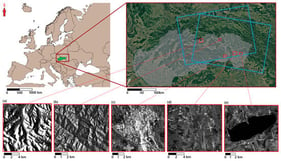
Overview map of the study areas used for SAR speckle noise filtering evaluation, showing the spatial distribution of five test sites in eastern Slovakia representing different land cover types: (a) mountainous area, (b) forested area, (c) urban area, (d) cropland area, and (e) water body area. Blue boxes indicate the Sentinel-1 scenes used in the analysis. Detailed zooms illustrate the extent and landscape context of each site.

Evaluation of the Accuracy of Direct Georeferencing of Photogrammetric Products in a Large Area with Steep Topography

  • Dania Isaura Pasillas-Pasillas,
  • Juvenal Villanueva-Maldonado and
  • Cruz Octavio Robles Rovelo
  • + 3 authors

Technological advancements have revolutionized photogrammetry, with the implementation of unmanned aerial vehicles for capturing images from different angles and the ease of obtaining sensor position information at the time of capture. This study evaluates the accuracy of direct georeferencing via Networked Transport of Radio Technical Commission for Maritime Services Via Internet Protocol, in the orthomosaic as a photogrammetric product in a large urban area with steep and highly variable topography, comparing it with the coordinates of nine checkpoints obtained with GNSS equipment connected to the National Active Geodetic Network, managed by the National Institute of Statistics and Geography of Mexico. An orthomosaic of the historic center of Zacatecas was obtained with a resolution of 2.70 cm/pixel. The orthomosaic coordinates, compared to those of the GNSS equipment, show a root mean square error (RMSE) of 0.78 m in the horizontal coordinates and an RMSE of 1.22 m in the vertical coordinates. Previous studies prove the efficiency of the Continuously Operating Reference Station module and network with other aircraft; this study determines that this is true for large areas with high coverage and quality in the internet network, but with rugged topography, the results are not accurate.

15 May 2026

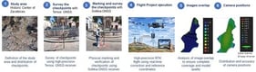
Methodology and phases for the photogrammetric project.

News & Conferences

Volumes

Latest Issues

Open for Submission

Editor's Choice

Reprints of Collections

Advances in Ocean Mapping and Nautical Cartography
Reprint

Advances in Ocean Mapping and Nautical Cartography

Editors: Giuseppe Masetti, Ian Church, Anand Hiroji, Ove Andersen
XFacebookLinkedIn
Geomatics - ISSN 2673-7418