


Abstract
Participatory photography is increasingly used in urban planning and co-creation, but its ability to promote spatial justice continues to raise doubts. This article analyses the conditions under which visual participation can challenge, reproduce or legitimise unequal power relations. Based on a critical–interpretative review of the literature published mainly between 2016 and 2026, a four-dimensional analytical framework is developed that addresses access to participation, control over the production and circulation of images, contradictory experiences of urban space, and the relationship between representation and material change. The synthesis identifies persistent inequalities in visual literacy and participation, in the control exercised by researchers and institutions over the selection and interpretation of images, and in the selective use of visual evidence to support established agendas. It also shows how participatory images can reveal divergent spatial experiences that consensus-oriented planning may overlook. Emerging generative AI tools also raise new questions about representational bias and visual credibility. The findings suggest that the emancipatory potential of participatory photography depends less on the technique itself than on participants’ authority over visual narratives, institutional accountability, and the translation of recognition into procedural influence or tangible outcomes. The conceptual framework developed provides an interpretative basis for assessing these conditions, whilst recognising that its explanatory value requires further empirical testing.
1. Introduction
Photography has emerged as a key medium in participatory urban planning and co-creation processes. Photovoice projects, mobile photomapping applications and geospatial visual methods promise to democratise spatial governance, amplifying marginalised voices and translating lived experience into applicable planning knowledge [1,2,3]. This ‘visual turn’ in participatory urbanism signals broader shifts towards community-based participatory research, frameworks of justice in design, and epistemic pluralism in the way cities are represented and transformed [4]. Participatory photography methods have become widespread in various fields, such as public health, urban planning, community development and environmental justice, amongst others, as tools that appear to shift authority from experts to residents, enabling communities to highlight their spatial experiences, set priorities and influence policy [5,6,7].
Some conceptual distinctions are necessary, however, as the terminology surrounding visual participation is not always used consistently. Throughout this article, participatory photography is employed as an overarching term encompassing practices in which participants contribute to the production and, to varying degrees, interpretation and use of photographic images. Photovoice refers more specifically to the participatory methodology developed by Wang and Burris [1], which combines participant-generated photography, collective reflection and an orientation towards social or policy change. The broader expression “visual methods” include photography alongside other forms of visual inquiry, such as participatory mapping and video-based approaches. “Visual co-creation”, in turn, refers to collaborative processes through which participants actively contribute to the production and interpretation of visual knowledge. Within urban planning, co-creation is understood as a form of collaborative knowledge production in which communities and institutions jointly define problems, generate evidence and negotiate responses. These concepts are related but not interchangeable. In particular, participatory photography does not necessarily imply genuine co-creation, since control over the selection, interpretation and institutional circulation of images may remain unequally distributed.
The proliferation of cameras in participatory planning therefore calls for critical analysis. Photography is not a neutral technology of representation, but rather a historically situated practice, rooted in colonial legacies, capitalist logics and asymmetrical power relations [8,9,10]. The camera has long served as an instrument of surveillance, classification and control, documenting the poor for the purposes of social reform, the colonised for anthropological knowledge, and those deemed deviant for legal punishment [11]. These histories do not disappear when cameras are distributed to community members. They continue to shape what can be photographed, who takes the photographs, how images are selected and interpreted, where they circulate and what institutional use is made of them. The possibility of producing alternative representations of urban space must therefore be distinguished from the capacity to influence the decisions and material conditions that shape that space.
This tension is particularly relevant to contemporary debates on spatial justice. Participatory photography may make previously marginalised experiences visible, challenge dominant urban narratives and broaden the forms of knowledge considered legitimate in planning processes. Yet visibility alone does not guarantee recognition, just as recognition does not necessarily lead to a redistribution of resources or decision-making power. Communities may be invited to document their living environments whilst remaining excluded from decisions concerning the interpretation of their images or the implementation of proposed changes. Photography can thus contribute to more inclusive forms of urban knowledge while simultaneously reproducing existing inequalities in participation, representation and institutional authority. The central issue is not simply whether communities are given opportunities to produce images, but whether they retain meaningful influence over how those images are interpreted, mobilised and translated (or not) into action.
In this context, the study seeks to establish a framework that is both critical and interpretative in order to understand the role of photography in urban co-creation, based on contributions to social, spatial and epistemic justice. Young’s [12] analysis of structural oppression and exclusion, Fricker’s [13] concept of epistemic injustice, Soja’s [14] understanding of spatial justice and Fraser’s [15] distinction between recognition and redistribution provide complementary perspectives on the relationships between participation, knowledge, power and material transformation. Building on these theoretical contributions and the critical interpretation of recent empirical research, we argue that participatory photography functions simultaneously as a technology of visibility and invisibility, bringing certain urban realities into view whilst potentially obscuring others. Its contribution to spatial justice depends not only on the opportunities it creates for expression, but also on the political and institutional conditions governing the production of visual knowledge and its incorporation into decision-making processes.
Four interrelated analytical dimensions structure this argument: (i) access to participation and the exclusions it reproduces; (ii) control over the production, selection, interpretation and circulation of images; (iii) divergent spatial experiences and conflicts of use; and (iv) the gap between representation and material change. These dimensions are not conceived as independent or sequential stages, but as interconnected aspects of the power relations embedded in participatory visual practices. Together, they provide a framework for examining the conditions under which photography may challenge established forms of spatial knowledge and institutional authority, as well as the circumstances in which apparently inclusive practices reproduce existing asymmetries. Particular attention is given to the distinction between participation as an opportunity for expression and co-creation as a process involving meaningful influence over knowledge production, the definition of urban problems and the negotiation of collective responses.
Three research questions guide the analysis. First, under what conditions does participatory photography shift power relations between communities and planning institutions? Second, how do different forms of visual documentation, including documentary photography, georeferenced evidence and AI-generated visualisations, function as instruments of inclusion or exclusion in planning processes? Third, what institutional and methodological conditions are necessary for visual participation to contribute to spatial justice beyond recognition? Addressing these questions requires moving beyond assessments of participatory photography as an inherently empowering methodology towards a more critical examination of the relationships between visual representation, community agency and institutional transformation.
The article is organised as follows. Section 2 outlines the methodological approach. Section 3 examines the origins, claims and conditions of participatory visual methods. Section 4 addresses power asymmetries, selective participation and the limits of recognition, whilst Section 5 explores urban narratives, conflicting spatial experiences and selective invisibility. Section 6 discusses methodological approaches oriented towards justice, and Section 7 considers the emerging implications of artificial intelligence. Section 8 brings these strands together to examine how community control and institutional conditions shape the outcomes of visual participation. Finally, Section 9 identifies the conditions under which participatory photography may contribute to more equitable and transformative urban planning practices.
2. Methodology
This article adopts a critical–interpretative review approach to examine the relationships between photography, power, spatial justice and participatory urban planning. Rather than seeking to provide an exhaustive systematic assessment of the effectiveness of participatory photography, the review aims to identify, compare and critically interpret the theoretical assumptions, methodological approaches and empirical findings that have shaped recent debates on visual participation and urban co-creation.
The literature was identified through searches conducted in three academic databases and search platforms: Scopus, Web of Science and Google Scholar. The search strategy combined terms relating to visual methodologies (“photovoice”, “participatory photography”, “photography”, “visual methods”, “photo-elicitation” and “photomapping”), participatory urban processes (“urban planning”, “urban co-creation”, “co-production”, “public participation”, “citizen participation” and “urban governance”), and critical perspectives on participation (“spatial justice”, “social justice”, “urban citizenship”, “inclusion”, “exclusion”, “empowerment” and “power relations”). These terms informed several Boolean combinations using AND and OR operators to identify literature situated at the intersection of participatory visual practices, urban governance and questions of justice and power.
The selection of sources was guided by their conceptual relevance and analytical contribution to the research questions. Publications were considered relevant when they contributed to at least one of the following areas: (a) participatory photography, photovoice or related visual methodologies in urban or peri-urban contexts; (b) public participation, citizenship, spatial justice, inclusion, exclusion or power relations; (c) the production, interpretation and institutional use of visual knowledge; or (d) the ethical, political and methodological implications of participatory visual research. These areas of relevance were not mutually exclusive. Sources were excluded when closer reading showed that they did not make a substantive contribution to these areas or to the research questions. Studies of non-participatory visual representation were retained where they contributed to the critical analysis of power, urban narratives or the institutional use of images. Uses of photography that were merely illustrative and offered no such analytical contribution fell outside the scope of the review.
For the purposes of this review, the analytical corpus comprises the sources explicitly mobilised in the substantive analysis in Section 3, Section 4, Section 5, Section 6 and Section 7, including the theoretical foundations used to interpret the evidence. A retrospective audit of the manuscript identified 42 such sources, alongside seven additional sources cited only in the Introduction and two cited only in the Methodology. Classified by their predominant contribution, the analytical corpus comprises approximately 29 empirical contributions or research-based methodological reflections, nine theoretical or conceptual–methodological contributions, three literature reviews and one institutional project account. This classification describes the principal contribution of each publication, whilst recognising that several sources combine empirical, theoretical and methodological elements. The conceptual–methodological group includes a proposal evaluated through simulation. Each publication is counted once, irrespective of the number of analytical dimensions it informs; different publications arising from the same project are not treated as independent empirical cases.
No document-level screening log was maintained during the original review. The corpus count and its approximate composition were therefore reconstructed retrospectively from the sources mobilised in the manuscript. This reconstruction establishes the documentary basis of the analysis but does not recover the original search and selection process; reliable counts of initially identified or excluded documents, including exclusions by stage or reason, cannot be reported.
The review primarily covers the period from 2016 to 2026. This temporal delimitation reflects a combination of political, methodological and technological developments. First, the decade following the most acute phases of the 2008–2009 global financial crisis and the subsequent implementation of austerity policies provides a particularly relevant context for examining changing relationships between urban governance, social inequalities, public participation and claims for spatial justice [16]. Second, the selected period makes it possible to analyse more recent developments in participatory photography, particularly its integration into urban planning, community-based research and processes of knowledge co-production. Third, the growing accessibility of digital photography, mobile technologies and participatory mapping platforms has transformed the conditions under which visual representations of urban space are produced, shared and mobilised in public decision-making. More recently, the emergence of generative artificial intelligence has introduced additional challenges concerning visual authenticity, representation and the control of spatial narratives. The 2016–2026 period is therefore understood as an analytically relevant window rather than a definitive historical turning point. Seminal contributions published before 2016 were retained where necessary to establish the conceptual and methodological foundations of the analysis.
The analytical approach is deliberately reflexive and interpretative. Sources were examined in relation to four interconnected dimensions: (i) access to participation and the exclusions it reproduces; (ii) control over the production, selection, interpretation and circulation of images; (iii) divergent spatial experiences and conflicts of use; and (iv) the relationship between visual representation, institutional recognition and material change.
The four analytical dimensions were developed through iterative reading and thematic comparison of the selected literature, drawing on theoretical contributions regarding social, spatial and epistemic justice. The synthesis groups recurring issues according to the aspect of participatory visual practice that they illustrate. Barriers associated with visual literacy, mobility, time and recruitment are considered within the context of access to participation. Issues relating to image selection, facilitation, interpretation, authorship and circulation are grouped under the heading of control over visual knowledge. Contrasting accounts of belonging, exclusion and the use of shared spaces inform the dimension of divergent spatial experiences. Finally, the differences between visibility, recognition, institutional responses and documented changes inform the dimension relating to the relationship between representation and material transformation.
These groupings foster a dialogue between the analysed literature and Young’s [12] description of structural exclusion, Fricker’s [13] concept of epistemic injustice, Soja’s [14] understanding of spatial justice, and Fraser’s [15] distinction between recognition and redistribution. These are, therefore, theoretically grounded interpretative categories, rather than the result of a purely inductive classification. Their boundaries remain permeable, as the researcher’s mediation can affect both access to and control over the images, whilst the institutional uses of the photographs link control over representation to opportunities for procedural or material change. Ethical concerns, surveillance and accountability also encompass various dimensions. The same publication may therefore cover more than one dimension, and so the aim of the framework is to distinguish interconnected mechanisms, rather than to assign studies to mutually exclusive categories.
Particular attention was given to tensions and contradictions between the emancipatory claims associated with participatory photography and the political and institutional conditions affecting its outcomes. Empirical studies, theoretical contributions, literature reviews and institutional accounts were considered according to their respective evidential status. Participants’ testimonies reported in the reviewed literature were treated as mediated secondary evidence rather than direct fieldwork material. The resulting synthesis seeks to develop a critical understanding of the conditions under which participatory photography may contribute to spatial justice, whilst recognising the limitations of the available evidence and the interpretative character of the review.
The geographical and linguistic structure of the corpus was also taken into account when interpreting the results. The prevalence of English-language publications conducted in contexts within the Global North may give greater prominence to certain institutional arrangements, conceptions of participation and approaches to spatial justice, although the study includes references from other contexts, as in the case of Quesada Avendaño [17]. Consequently, the analytical dimensions are treated as context-sensitive interpretative categories, instead of explanations universally applicable to participatory photography practices.
3. Visual Methods in Urban Planning: Origins, Claims and Conditions
Photovoice emerged in the mid-1990s as a participatory action research method designed to enable marginalised communities to document their lived experiences and influence policy through photography and collective dialogue [1]. Rooted in Paulo Freire’s critical pedagogy, feminist theory and the traditions of documentary photography, it was initially developed for public health research, before spreading to the fields of urban planning, community development and environmental justice [18]. This trajectory reflects broader trends towards participatory governance and the recognition of experiential knowledge as legitimate planning evidence [3,19].
Its advocates argue that visual methods offer clear advantages over conventional participatory techniques, as photographs provide concrete evidence of spatial conditions and can be more persuasive than verbal testimony in institutional contexts. They also consider that the act of photographic documentation encourages critical reflection on environments that are taken for granted, and even argue that the collective analysis of images develops the analytical capacity of the community as a whole [1,2]. Several empirical studies document significant impacts. A ‘photovoice’ study on physical activity and urban design in socio-economically diverse neighbourhoods in Bilbao led to policy recommendations that were presented to municipal planning authorities [20]. A citizen science and ‘photovoice’ approach to mapping food resources produced evidence that informed food system planning at the municipal level [21].
The relationship between visual participation and social change also calls for attention to be paid to the types of outcomes reported. Sanon et al. [22] analysed 30 studies on the ‘photovoice’ method published between 2008 and 2013, examining their intentions regarding social justice and the reported impacts. Their analysis addressed research on the ‘photovoice’ method more broadly, rather than focusing specifically on applications related to urban planning. Within their analytical framework, all 30 studies addressed raising awareness of social justice, whilst 11 reported impacts classified as ‘improvement’ and three as ‘transformation’. These categories should not be interpreted as mutually exclusive stages, nor as universal measures of the effectiveness of ‘photovoice’.
In this analysis, this review serves as a basis for distinguishing between making experiences visible and documenting changes that go beyond raising awareness. Its findings do not establish how often ‘photovoice’ produces procedural or material changes in urban planning, nor can the reported figures be directly extrapolated to urban co-creation projects. Their relevance is analytical, in that they reinforce the need to distinguish between raising awareness, improvements and structural change, whilst examining the objectives, institutional conditions and available evidence for each project.
The available evidence suggests that certain conditions are frequently associated with more significant outcomes: i. the extent to which the production and interpretation of images are controlled by the participants, rather than by the researchers; ii. the presence of institutional relationships capable of translating visual evidence into binding commitments; and iii. the integration of ‘photovoice’ into broader organizational strategies, rather than its implementation as an isolated data-collection exercise.
4. Power Asymmetries and Exclusions in Participatory Photography
4.1. Access and Selective Participation
The assumption that photography is universally accessible is often contradicted in practice. Visual literacy, that is, the ability to produce images that convey intended meanings within dominant photographic conventions, is unevenly distributed across populations and is shaped by cultural capital and prior exposure to image-making [2,23]. When projects distribute cameras without addressing these inequalities, they risk reproducing hierarchies of cultural capital rather than dismantling them.
The MOSAIC project, conducted by the Environmental Social Sciences Research Group (ESSRG) in a rural Hungarian community to explore land-use change and adaptation to climate change, illustrates these dynamics with methodological transparency. Although it was explicitly stated that no prior experience was required, many community members refused to take part, viewing photography as a task requiring professional skills. Participation was initially limited to one amateur photographer and two professional photographers. The team responded adaptively: after the initial collection yielded over 100 photographs, the ESSRG researchers carried out a pre-selection process to construct a coherent visual narrative. They then returned with printed photographs displayed in a small exhibition, which sparked wider curiosity within the community and attracted a further five participants to the discussions at the second workshop. The team also presented a printed map of the village, proposed by Fanni Sall, which enabled participants to geographically locate their images and anchor the narratives to the site, transforming the method into a combined visual–cartographic dialogue [24].
There are three reasons why this rural case study is of methodological interest to participatory urban planning. Firstly, perceived photographic competence can act as a barrier to participation, even when the equipment and formal opportunities for participation are available. Urban projects can and should therefore consider whether their recruitment process and activities implicitly favour participants who already feel confident in producing images. Secondly, the pre-selection of photographs by the researchers illustrates how editorial mediation shapes the experiences and narratives available for collective discussion. In urban planning contexts, this raises questions about who defines the selection criteria and whether participants can review, challenge or supplement the selected images. Finally, the use of printed photographs and a map created additional opportunities for engagement beyond the initial production of images. Similar approaches could enable urban participants to contribute through discussion and spatial interpretation, even when they do not take photographs themselves.
These mechanisms relate to access, editorial authority and the organisation of participation, rather than being characteristics exclusive to rural contexts. Their relevance to urban planning is therefore analytical and methodological; the MOSAIC case does not establish that the same adaptations would produce equivalent results in urban projects. Differences in population density, social relations, mobility and institutional arrangements require a context-specific assessment.
Technological and logistical barriers exacerbate selective access. Traditional ‘photovoice’ protocols assume that participants have secure housing, stable routines that allow for involvement over several weeks, and freedom of movement [23]. These assumptions exclude populations experiencing homelessness, housing instability or mobility restrictions [25]. For many potential participants, time, safety and transport are more important than access to equipment.
4.2. Control over the Images: A Chain of Editorial Decisions
A second structural problem concerns the complex issue of control over images. A participant may have complete control over the photograph they take, choosing the subject, the angle and the moment, without having any control over what happens afterwards. Which images are shortlisted for group discussion? How are they captioned? Which ones are chosen for exhibition? How are they subsequently used in institutional reports? Each stage in this chain is a formally justified editorial decision which may, progressively, distance the photographer from authorship of their own image.
The researcher’s control is most evident in the facilitation process. The suggestions, questions and thematic priorities that researchers bring to group discussions determine which photographs receive analytical attention and which remain marginal [2,26]. Funding structures and institutional deadlines further restrict the community’s autonomy, defining what counts as a relevant research question even before the participants arrive. Ethical review processes add another layer of mediation, as institutional review boards often require faces to be blurred or participants to be anonymized, a safeguard to which many participants explicitly object, having sought public recognition as the authors of their own stories [27]. The tension between institutional risk management and participants’ desire for visibility is, in itself, a power asymmetry that ‘photovoice’ protocols have failed to resolve.
4.3. Security, Surveillance and the Social Significance of the Camera
These tensions become even more acute in contexts of social conflict. Esther Prins’s [28] fieldwork in El Salvador documents an incident in which a photograph of a sugar-cane field taken by a participant led the landowner to accuse the researcher of having sent the participant to plan an arson attack. The camera, regardless of the actual intention, was interpreted by the landowner as an instrument of surveillance and a threat. This episode does not demonstrate that participatory photography is inherently dangerous, but it does at least reveal that the meaning of the camera is not controlled by the person holding it but is also shaped by observers and by the political contexts in which the images are produced and received. Attention to context-specific risks is part of a responsible participatory approach and is not a reason to abandon the method.
4.4. The Gap Between Recognition and Concrete Change
Institutional actors often engage with ‘Photovoice’ in ways that draw legitimacy without redistributing power. Planning authorities may attend exhibitions, express genuine appreciation for the community’s perspectives and incorporate selected images into reports, whilst ultimately pushing ahead with predetermined agendas [2,7]. This dynamic requires careful interpretation. Recognition, which is the experience of being seen and heard, is no trivial outcome for communities that have been systematically rendered invisible. For some participants, having photographs displayed to a public audience represents a significant form of recognition [18]. However, recognition, influence over institutional procedures and the redistribution of material resources are distinct outcomes that should not be reduced to a single verdict on whether a project ‘was successful’. Assessing ‘Photovoice’ fairly requires that the evaluation corresponds to the project’s stated objectives and the available evidence, distinguishing between the absence of documented effects and the absence of effects, and between the absence of follow-up and the absence of change. These findings point to distinct dimensions of spatial justice. Procedural justice concerns fair and inclusive participation in decision-making processes [12]. Recognitive justice addresses the recognition of diverse identities, experiences and systems of spatial knowledge [15]. Distributive justice refers to the equitable distribution of spatial resources, opportunities and burdens [14]. Epistemic justice involves recognising marginalised communities as legitimate holders of knowledge and rectifying hermeneutic and testimonial injustices [13]. Visibility, as this analysis demonstrates, does not automatically lead to recognition, and recognition does not automatically lead to redistribution.
5. Photography, Urban Narratives and Spatial Conflict
5.1. Constructing and Challenging Urban Narratives
Photography has long been fundamental to the construction of narratives about urban space, stories of progress or decline, renewal or decay, which shape public opinion and legitimise institutional interventions [29,30]. Advertising billboards for property developments present inspiring depictions of gleaming towers and diverse residents, whilst concealing the displacement and erasure of existing communities [31]. Historical analyses show how photographs of ‘run-down’ neighbourhoods were used to garner public support for demolition and regeneration projects that destroyed thriving working-class communities [32]. Contemporary urban communication continues to employ visual strategies that normalise displacement as an improvement, rendering the ‘previous’ conditions unrecognisable once the transformation is complete.
Contrary to dominant narratives, participatory photography has served as a tool for counter-representation. Strasser’s [33] work on gentrification-induced displacement in Deptford, south-east London demonstrates how community photography can bring to light the human costs of urban transformation that official narratives overlook. Community photo albums in Detroit have brought together alternative visual histories that highlight the agency of Black residents, challenging the ‘ruin’ aesthetic that drew artists and the media to the city’s physical decay [29]. The ability to produce and disseminate such counter-narratives, however, remains limited by unequal access to platforms, galleries and institutional audiences. Counter-narratives typically reach smaller, already sympathetic audiences, in comparison with development marketing or state communications.
5.2. Divergent Experiences and the Limits of Consensus
One of the most instructive contributions of ‘photovoice’ linked to specific territories is its ability to document contradictory experiences of the same urban spaces. The ‘Urban Belonging’ project, carried out with participants from seven marginalised communities in Copenhagen, generated 1459 geolocated photographs, which were co-interpreted in group sessions [3]. The dataset revealed community-specific patterns in terms of belonging and exclusion, alongside, crucially, divergent interpretations of identical spaces.
The project’s documentation of cycling infrastructure illustrates this point well. For participants without mobility restrictions, the accumulation of bicycles on pavements symbolised Copenhagen’s sustainable urban identity, but for participants in wheelchairs, this same accumulation blocked pedestrian access and forced them to use the carriageway; furthermore, for participants with mental health vulnerabilities, the visual density caused anxiety. The same physical layout produces incompatible experiences of belonging and exclusion, depending on each individual’s position and vulnerability. Participatory photography does not resolve this conflict. What georeferenced methods, which preserve spatial location and enable cross-group interpretation, can do is make these divergent experiences analytically manageable and, in so doing, challenge the assumption that planning decisions must be optimised for a single imaginary user. Consensus as the aim of participation may be a structural problem rather than an aspiration.
The importance of recognising diverse spatial experiences is also highlighted by Sahtout et al. [34] in their study of participatory urban design in Tataouine, Tunisia. Through user experience mapping and the analysis of local cultural practices, the authors demonstrate how residents’ relationships with public spaces and urban heritage can inform more context-sensitive planning approaches. Although the study does not employ photovoice, it provides a complementary perspective on the role of participatory visual and spatial methodologies in recognising culturally situated experiences of urban space. It also suggests that meaningful participation requires attention not only to differences between social groups, but also to the cultural and territorial contexts in which spatial meanings are constructed.
5.3. Aestheticisation and Selective Invisibility
Urban beautification projects (murals, façade improvements, landscape redesigns) are often used as compensatory gestures that create the appearance of investment, whilst facilitating displacement [35,36]. Visual interventions create narratives of neighbourhood improvement that attract capital, increase property values and pave the way for gentrification, whilst rendering the displaced communities aesthetically invisible.
The findings of the ‘Urban Belonging’ project regarding Ørstedsparken in Copenhagen illustrate how a landscape intervention produces effects of exclusion that are only visible from certain social positions. According to the project’s documentation and analysis, the clearing of dense vegetation in the park, as reported by participants, removed spatial resources on which homeless people who frequented a nearby food bank relied for shelter and privacy [3,37]. From the perspective of official planning, an open and visible park may appear safer and more attractive; from the perspective of someone without a home, dense vegetation provides shelter. This does not determine the official intention behind the intervention, nor does the available documentation demonstrate a causal link with the exclusion of any specific population. What the ‘photovoice’ evidence does is make visible both the change in the landscape and the effects as experienced, thereby challenging the claim that urban improvements are uniformly experienced as improvements. The case illustrates the capacity of ‘photovoice’ not only to document exclusion, but also to reveal it where official accounts would not record it.
6. Methodological Innovations Geared Towards Justice
6.1. Geospatial and Intersectional Approaches
Geospatial ‘photovoice’ represents a significant methodological innovation, integrating GPS-tagged photography with mobile applications and geographic information systems to enable spatial analysis at scales not available in conventional qualitative research [3,19]. The ‘Urban Belonging’ project demonstrates the ability to move between individual experience and collective spatial patterns, and between demographic and post-demographic modes of analysis. Following initial sessions specific to each community, participants were regrouped around shared spatial experiences rather than identity categories, which facilitated dialogue between communities and revealed intersectional dimensions that demographic groupings can obscure. The project’s implementation also utilised automated face-blurring algorithms, whilst retaining spatial and contextual information, thereby addressing ethical concerns regarding surveillance without sacrificing the granularity essential for planning applications.
Intersectional approaches are essential to any serious claim to spatial justice. Gilchrist’s [38] feminist ‘photovoice’ study with women from East and South-East Asia in the UK draws on intersectional analysis to reveal how racism, sexism and xenophobia combine to produce specific forms of urban exclusion. Hassen’s [39] ‘photovoice’ study on urban green spaces documents how Black residents experience surveillance, racialised violence and restricted access in spaces formally designated as public. These studies demonstrate that the ‘voice of the community’ is not homogeneous and that revealing differences within communities requires deliberate design, rather than the assumption that a shared geography produces shared priorities.
6.2. Counter-Mapping, Feminist Methodologies and Reflective Co-Interpretation
Counter-mapping positions participatory visual documentation in explicit opposition to dominant spatial regimes, documenting contested spaces, informal land uses and alternative spatial imaginaries [21,40]. This approach is most effective when combined with organising strategies and rights-based advocacy, rather than being used as isolated research exercises. Feminist and decolonial methodologies emphasise long-term accountability to communities, rejecting extractivist models that benefit academic careers at the expense of the communities whose experiences are mobilised as research data [41,42]. This means paying attention to the ownership of images, data sharing and what happens to the collected materials once the project has ended, issues that standard ‘photovoice’ protocols rarely address.
Reflective co-interpretation challenges the conventional division between data collection by participants and analysis by researchers. Rather than treating photographs as raw data, reflective approaches position interpretation as a continuous and collaborative process, in which participants retain authority over the meanings of their images throughout the entire process [43]. This requires researchers to share draft analyses, invite critique and revise their conclusions in response to that critique, a form of accountability that substantially alters the epistemic contract of ‘Photovoice’.
Innovations in dissemination are equally necessary. Traditional ‘photovoice’ exhibitions often fail to reach policy-makers with the authority to bring about concrete change [2,7]. Some projects have integrated participatory photography into formal planning processes to ensure that visual evidence is directly incorporated into decision-making procedures. Others have experimented with policy-oriented formats, regulatory proposals and planning challenges that translate community documentation into institutional language without delegating the construction of meaning to institutional actors. None of these innovations guarantees concrete results; however, they do bridge the gap between community expression and institutional consideration.
7. Artificial Intelligence and the Visual Construction of Urban Futures
Urban visualisation now encompasses at least three distinct types of visual documentation, each carrying different epistemic weights and different implications for participation. Documentary photography, produced by or with community members to evidence lived spatial conditions, retains a direct indexical relationship with the reality it depicts. Georeferenced visual evidence, including tagged photographs and spatial data visualisations, combines image documentation with locational precision that enhances its utility as planning evidence. AI-generated visualisation, by contrast, produces images that may be photorealistic in appearance but bear no necessary relationship to existing conditions; their persuasive power derives from aesthetic credibility rather than evidential grounding. These distinctions are analytically consequential: treating the three types as equivalent, or conflating AI-generated imagery with community documentation, carries significant risks for the epistemic authority of participatory visual methods.
Generative AI tools, capable of producing photorealistic urban images from text prompts, have emerged as potential instruments for participatory design, enabling non-specialists to visualise alternative urban futures without the need for architectural expertise [44,45]. Empirical studies on AI in participatory design contexts reveal that the images generated can facilitate a productive dialogue amongst various stakeholders, providing concrete visual references for critique and refinement [44].
These concerns extend beyond generative artificial intelligence to the broader adoption of computational and data-driven approaches in urban design. Gün [46] observes that, despite the growing potential of digital tools to transform design processes and support data-informed decision-making, their contribution to citizen empowerment and participatory practices remains limited. This distinction reinforces the need to examine technological innovation separately from the redistribution of authority, as more sophisticated tools do not necessarily produce more inclusive or democratic planning processes.
The concerns are primarily structural in nature. Training datasets for image-generation models disproportionately represent affluent, Western and predominantly white urban environments, meaning that AI outputs reproduce these aesthetic preferences even when instructed otherwise [47,48]. Linguistic bias disadvantages speakers of languages other than English and communities whose spatial knowledge is rooted in other languages [49]. The ability of generative AI to produce photorealistic yet entirely fictional images raises crucial epistemological questions. Indeed, if it is possible to produce visualisations that are not based on real locations or feasibility constraints, it becomes difficult to maintain the distinction between evidence-based planning and speculative imagery [50,51].
These dynamics do more than simply exacerbate the existing risks of participatory photography because they have the potential to undermine its ambition to serve as evidence. If institutional audiences are unable to distinguish between community photographs documenting living conditions and AI-generated images serving the interests of property developers, the epistemic authority of participatory visual documentation is compromised. The regulation of AI in urban visualisation is therefore a question of whose knowledge counts and who controls the visual terms of planning discourse [46].
At the very least, the responsible use of AI visualisation in participatory planning contexts should require explicit disclosure to community participants and the planning’s target audience as to whether the images are AI-generated or produced by the community; the preservation of the primacy of community documentation as the primary layer of evidence; ensuring that communities retain authority over how, when and whether AI-generated images may be used to represent their spatial claims; and the active review of the training datasets on which the implemented models are based, paying attention to the communities and spatial contexts that these over- or under-represent.
8. Discussion
Four structural problems emerge from all this evidence analysed. Firstly, access to participation is limited not only by obvious barriers (digital exclusion, mobility), but also by more subtle forces: the perception of photography as a specialised practice, selection pressures arising from research questions defined by researchers, and the time demands of projects lasting several weeks on people with precarious livelihoods. The experience of the MOSAIC project demonstrates that low initial participation can elicit adaptive responses that ultimately broaden engagement; yet the conditions that enable such adaptation—a flexible design, genuine community control over the research question, and adequate time—are rarely present in commissioned institutional programmes.
Secondly, the chain leading from the production of images to institutional decision-making is longer and more mediated than most methodological accounts acknowledge. A photographer controls the subject they frame but they do not, therefore, control the pre-selection, captions, curation of the exhibition or subsequent institutional use. At each stage, editorial decisions may or may not preserve the intended meanings. Researchers and professionals who claim to have ‘given a voice’ to communities without monitoring what happens to the images throughout this chain are making a rather flimsy claim.
Thirdly, the documentation of contradictory spatial experiences (bicycles as an icon or a barrier; the park’s vegetation as an amenity or a shelter) challenges the model of consensus implicit in much of participatory planning practice. The analytical value of participatory photography may lie not in the production of consensus, but in making experiential divergences manageable, thereby enabling planning to take account of heterogeneous users rather than an imaginary ‘average resident’.
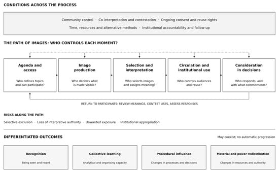
Fourthly, the distance between representation and concrete change depends on factors that ‘photovoice’ cannot, on its own, provide, namely the institutional willingness to make binding commitments, the political conditions that make redistribution possible, or the presence of organised communities capable of holding institutions to account over time. These conditions can be supported by a carefully considered approach to ‘photovoice’, notably through the integration of visual methods into broader organisational strategies, but they cannot be replaced by methodological refinement (see Figure 1).
Figure 1.
From visual participation to spatial justice: mediation, control and differentiated outcomes. Source: author’s synthesis.
The framework identifies moments when participants’ authority over the images and their meanings may be preserved, shared or weakened. Cross-cutting conditions shape the process, whilst feedback enables participants to challenge interpretations and uses. However, these outcomes may coexist and do not in fact constitute an automatic progression from recognition to redistribution. The framework presented here is purely conceptual and analytical in scope, having been developed through a critical engagement with recent empirical literature; however, it has not itself been subject to systematic empirical validation. When using it, its propositions should be regarded as hypotheses to be tested and refined through application, rather than as established conclusions.
In practice, these four dimensions can guide questions about the observable characteristics of participatory planning projects. Access to participation can be analysed through recruitment and attendance records, documented barriers to involvement, and the availability of alternatives to taking photographs. Control over visual knowledge can be assessed by identifying who selects the images, writes the captions and authorises their dissemination, alongside documented opportunities for participants to challenge interpretations, review selections or negotiate subsequent uses. Divergent spatial experiences can be analysed by checking whether contradictory interpretations of the same location are preserved in the discussions and project outcomes, and whether planning proposals explicitly address these differences. The relationship between representation and change can be explored through documented institutional responses to evidence generated by the community, identifiable changes in proposals or decision-making procedures, and records of implementation, resource allocation or subsequent material outcomes.
Relevant evidence may include project protocols, successive versions of image selections and captions, workshop records, participant accounts, institutional responses and monitoring documentation. The evaluation should distinguish between formal opportunities for participation and the influence demonstrated by participants, and between institutional acknowledgement and implemented change. These examples are primarily starting points for contextual research, rather than validated indicators or a scoring system. The absence of documented outcomes should be recorded as a limitation of the available evidence, rather than being automatically interpreted as a lack of change; similarly, observed changes should not be attributed to the participatory process without evidence to support this link.
All these structural observations do not support a deterministic acceptance or rejection of the method. The evidence analysed includes projects that have generated significant recognition, expanded the community’s analytical capacity and contributed to documented policy changes. These outcomes are valuable and should not be dismissed as mere consolation prizes for a method that has failed to bring about structural transformation. Distinguishing between recognition, learning, procedural influence and material redistribution is both analytically necessary and ethically important for an honest representation of what participatory photography can and cannot achieve.
The geographical concentration of the reviewed literature also raises questions concerning the transferability of these findings. Many of the institutional conditions identified as relevant to meaningful visual participation, including established participatory planning mechanisms, access to digital technologies and opportunities for engagement with public authorities, reflect contexts predominantly documented in Global North research. In settings characterised by different institutional capacities, informal governance arrangements or more pronounced inequalities in access to resources and political representation, the relationships between visual participation, recognition and material change may take different forms. The proposed analytical framework should therefore be understood as a context-sensitive contribution, requiring further examination across more diverse geographical and institutional settings.
9. Conclusions
Participatory photography is not, in itself, empowering or inevitably appropriative. It is a contested terrain where struggles over representation, knowledge and power are waged, and where the outcomes depend on conditions that go far beyond the methodology itself.
The evidence analysed here points to several conditions for a more equitable form of visual participation, presented not as guarantees of transformation, but as foundations for a practice that takes power seriously. Participants must be able to define the themes of their photography and challenge interpretations of their images throughout the entire process, not just at the time of collection. Control over the identification and reuse of images must remain with the participants, including the right to withdraw images from institutional circulation. This right raises a practical tension with institutional data-retention and archiving requirements, which frequently stipulate that planning-related evidence must be preserved for specified periods; resolving this tension requires explicit negotiation and contractual clarity before the project begins, not retrospective agreement. Alternatives to photography, such as mapping, storytelling and drawing, must be available to those for whom the camera is a barrier rather than a tool. The institutional response to the community’s visual evidence must be identifiable and traceable, and not merely appreciative.
Monitoring should be agreed upon from the beginning and assigned, first and foremost, to the authority or organisation responsible for the planning process, with a designated official or team responsible for maintaining records and submitting reports. Community representatives chosen by the participants should have opportunities to review how the images, interpretations and recommendations are used, to identify any deviations from the agreed meanings, and to request corrections or explanations. Researchers or facilitators may assist with documentation and the transfer of responsibilities, but ongoing oversight should not depend exclusively on their involvement or on volunteer community work. Accountability can be integrated into existing procedures for consultation, plan approval and implementation, through a documented response to the participatory outcomes, indicating which recommendations have been incorporated, modified, deferred or not taken forward, and why. Agreed information points, accessible feedback and a clear channel for raising concerns would enable participants to monitor both the institutional use of their contributions and any resulting commitments once the participatory activities have ended.
These conditions require institutional mechanisms, time, resources, genuine decision-making authority and long-term relationships, which are rarely available in standard participatory processes. However, demanding this is not utopian, as some of the projects analysed here demonstrate partial progress towards meeting these conditions, although none of them fulfils them in full. However, achieving this objective requires a deliberate political and institutional commitment, and not merely methodological innovation.
This analysis has a number of limitations worth noting. It is recognised that the corpus reflects what has been published and is accessible in English, which results in an over-representation of projects from the Global North and contexts with a strong academic publishing infrastructure. Projects without documented results are systematically under-represented in the published literature, and this invisibility may constitute a grave injustice. Project reports and institutional accounts of ‘photovoice’ do not constitute independent evaluations. Participants’ testimonies, where available, are mediated by their publication contexts and should not be treated as unfiltered evidence of their experience. These limitations call for caution when generalising and require that any individual case be treated as illustrative rather than representative.
Photography will continue to proliferate in urban planning and co-creation. The fundamental task is not to reject it, but rather to hold it to account, by questioning who controls the framing, who interprets the image, who benefits from its circulation, and who bears the costs of its misuse.
Funding
This research is financed by national funds through Fundação para a Ciência e a Tecnologia (FCT), I.P., under project CiTUA-Centre for Innovation in Territory, Urbanism and Architecture [UID/05703/2025].
Institutional Review Board Statement
Not applicable.
Informed Consent Statement
Not applicable.
Data Availability Statement
The original contributions presented in this study are included in the article. Further inquiries can be directed to the corresponding author.
Conflicts of Interest
The author declares no conflict of interest.
References
- Wang, C.; Burris, M.A. Photovoice: Concept, methodology, and use for participatory needs assessment. Health Educ. Behav. 1997, 24, 369–387. [Google Scholar] [CrossRef] [Scilit]
- Carpenter, J. Picture this: Exploring photovoice as a method to understand lived experiences in marginal neighbourhoods. Urban Plan. 2022, 7, 351–362. [Google Scholar] [CrossRef] [Scilit]
- Burgos-Thorsen, S.; Niederer, S.; Madsen, A.K. What is an inclusive city? Reconfiguring participation in planning with geospatial photovoice to unpack experiences of urban belonging among marginalised communities. Vis. Stud. 2024, 39, 144–163. [Google Scholar] [CrossRef] [Scilit]
- Costanza-Chock, S. Design Justice: Community-Led Practices to Build the Worlds We Need; MIT Press: Cambridge, MA, USA, 2020. [Google Scholar]
- Gullón, P.; Díez, J.; Conde, P.; Ramos, C.; Márquez, V.; Badland, H.; Escobar, F.; Franco, M. Using Photovoice to Examine Physical Activity in the Urban Context and Generate Policy Recommendations: The Heart Healthy Hoods Study. Int. J. Environ. Res. Public Health 2019, 16, 749. [Google Scholar] [CrossRef] [Scilit]
- Meenar, M.R.; Mandarano, L.A. Using photovoice and emotional maps to understand transitional urban neighborhoods. Cities 2021, 118, 103353. [Google Scholar] [CrossRef] [Scilit]
- Erfani, G. Visualising urban redevelopment: Photovoice as a narrative research method for investigating redevelopment processes and outcomes. Geoforum 2021, 126, 80–90. [Google Scholar] [CrossRef] [Scilit]
- Sontag, S. On photography; Farrar, Straus and Giroux: New York, NY, USA, 1977. [Google Scholar]
- Tagg, J. The Burden of Representation: Essays on Photographies and Histories; University of Minnesota Press: Minneapolis, MN, USA, 1993. [Google Scholar]
- Azoulay, A. The Civil Contract of Photography; Zone Books: Brooklyn, NY, USA, 2008. [Google Scholar]
- Sekula, A. The body and the archive. October 1986, 39, 3–64. [Google Scholar] [CrossRef] [Scilit]
- Young, I.M. Justice and the Politics of Difference; Princeton University Press: Princeton, NJ, USA, 1990. [Google Scholar]
- Fricker, M. Epistemic Injustice: Power and the Ethics of Knowing; Oxford University Press: Oxford, UK, 2007. [Google Scholar]
- Soja, E.W. Seeking Spatial Justice; University of Minnesota Press: Minneapolis, MN, USA, 2010. [Google Scholar]
- Fraser, N. From redistribution to recognition? Dilemmas of justice in a “post-socialist” age. New Left Rev. 1995, 212, 68–93. [Google Scholar] [CrossRef] [Scilit]
- Davies, J.S.; Blanco, I. Austerity urbanism: Patterns of neo-liberalisation and resistance in six cities of Spain and the UK. Environ. Plan. A 2017, 49, 1517–1536. [Google Scholar] [CrossRef] [Scilit]
- Quesada Avendaño, F. Ciudad y fotografía. Discursos visuales de poder en la ciudad de Guatemala, 1890–1930. In Cultura (Audio)visual y Espacios Públicos: (Re)inventando la Ciudad; Leroux, M.-C., Rondón, G.Z., Asperilla, E.P., Eds.; Université de Limoges: Limoges, France, 2024; pp. 63–78. [Google Scholar] [CrossRef] [Scilit]
- Seitz, C.M.; Orsini, M.M. Thirty years of implementing the photovoice method: Insights from a review of reviews. Health Promot. Pract. 2022, 23, 281–288. [Google Scholar] [CrossRef] [Scilit]
- Madsen, A.K.; Burgos-Thorsen, S.; De Gaetano, C.; Ehn, D.; Groen, M.; Niederer, S.; Norsk, K.; Simonsen, T. The urban belonging photo app: A toolkit for studying place attachments with digital and participatory methods. Methodol. Innov. 2023, 16, 292–314. [Google Scholar] [CrossRef] [Scilit]
- San-Juan-Escudero, A.; Ballesteros-Peña, S.; Fernández-Aedo, I.; Caballero Sánchez, S.; Fernandez-Alonso, J.; Gullón, P.; Franco, M.; Gravina, L. Exploring urban design’s impact on physical activity: A participatory photovoice study across socioeconomically diverse neighborhoods. Landsc. Urban Plan. 2025, 259, 105334. [Google Scholar] [CrossRef] [Scilit]
- Soma, T.; Li, B.; Shulman, T. A citizen science and photovoice approach to food asset mapping and food system planning. J. Plan. Educ. Res. 2024, 44, 1503–1515. [Google Scholar] [CrossRef] [Scilit]
- Sanon, M.A.; Evans-Agnew, R.A.; Boutain, D.M. An exploration of social justice intent in photovoice research studies from 2008 to 2013. Nurs. Inq. 2014, 21, 212–226. [Google Scholar] [CrossRef] [Scilit]
- Bandauko, E.; Arku, G. The power of a camera: Fieldwork experiences from using participatory photovoice. Int. J. Qual. Methods 2023, 22, 1–13. [Google Scholar] [CrossRef] [Scilit]
- Czeglédi, A.; Sall, F.; Berta, G. Photovoice for Land-Use Change: A Visual Tool for Participatory Research. MOSAIC Project/ESSRG. 8 May 2025. Available online: https://mosaic-europe.eu/mosaic/article/photovoice-for-land-use-change:-a-visual-tool-for-participatory-research (accessed on 29 August 2026).
- Henry, R.; Gabel, C. “It’s not just a picture when lives are at stake”: Ethical considerations and photovoice methods with Indigenous peoples engaged in street lifestyles. J. Educ. Thought 2019, 52, 229–260. [Google Scholar] [CrossRef] [Scilit]
- Call-Cummings, M.; Martinez, S. Consciousness-raising or unintentionally oppressive? Qual. Rep. 2016, 21, 798–810. [Google Scholar] [CrossRef] [Scilit]
- Creighton, G.; Oliffe, J.L.; Ferlatte, O.; Bottorff, J.; Broom, A.; Jenkins, E.K. Photovoice ethics: Critical reflections from men’s mental health research. Qual. Health Res. 2018, 28, 446–455. [Google Scholar] [CrossRef] [Scilit]
- Prins, E. Participatory photography: A tool for empowerment or surveillance? Action Res. 2010, 8, 426–443. [Google Scholar] [CrossRef] [Scilit]
- Aelbrecht, W. Mind the information gap! Constructing counter-narratives for urban planning in Detroit’s photobooks. Soc. Cult. Geogr. 2026, 27, 41–65. [Google Scholar] [CrossRef] [Scilit]
- Nastasi, M.; Ponzini, D. Toward a photographic urbanism? Images iconizing cities and swaying urban transformation. In The Routledge Companion to Urban Imaginaries; Routledge: London, UK, 2018; pp. 217–231. [Google Scholar] [CrossRef] [Scilit]
- O’Mahony, E.; Lawton, P. Image circulation, development hoardings and new strategies of urban change. Geogr. Ann. Ser. B Hum. Geogr. 2019, 101, 202–218. [Google Scholar] [CrossRef] [Scilit]
- Grantmyre, L. Conflicting visions of renewal in Pittsburgh’s Hill District, 1950–1968. Urban Hist. 2016, 43, 639. [Google Scholar] [CrossRef] [Scilit]
- Strasser, A. Visibilising gentrification-induced displacement: A visual essay on the role of a socially and politically engaged photographic practice in housing activism. Vis. Stud. 2024, 39, 118–126. [Google Scholar] [CrossRef] [Scilit]
- Sahtout, I.; Ben Youssef Zorgati, I.; Lafhaj, Z. Integrating dynamic culture and participatory design in urban spaces for sustainable futures. J. Contemp. Urban Aff. 2024, 8, 212–231. [Google Scholar] [CrossRef] [Scilit]
- Pritchard, S. The artwashing of gentrification and social cleansing. In The Handbook of Displacement; Springer International Publishing: Cham, Switzerland, 2020; pp. 179–198. [Google Scholar] [CrossRef] [Scilit]
- Balliger, R. Painting over precarity: Community public art and the optics of dispossession, gentrification and governance in West Oakland, CA. J. Urban Cult. Stud. 2021, 8, 81–107. [Google Scholar] [CrossRef] [Scilit]
- Burgos-Thorsen, S. Expanding Data Imaginaries in Urban Planning: Foregrounding Lived Experience and Community Voices in Studies of Cities with Participatory and Digital Visual Methods. Doctoral Dissertation, Aalborg University, Aalborg, Denmark, 2023. [Google Scholar] [CrossRef] [Scilit]
- Gilchrist, L. Framing the unseen: Feminist photovoice and intersectionality in shaping urban exclusion and agency for ESEA women. Gend. Justice 2025, 1, 202–228. [Google Scholar] [CrossRef] [Scilit]
- Hassen, N. Narratives of exclusion: A photovoice study towards racial equity and justice in public urban greenspaces. Landsc. Urban Plan. 2025, 254, 105233. [Google Scholar] [CrossRef] [Scilit]
- Black, G.F.; Petersen, L.; Mpofu-Mketwa, T.J.; Dick, L.; Wilson, A.; Ncube, S.; Abrams, A.; Carden, K.; Dickie, J.; Hamilton-Smith, N.; et al. Participatory Visual Methods and the Mobilization of Community Knowledge: Working Towards Community-Derived Disaster Risk Management in the Context of Advancing Climate Change. J. Particip. Res. Methods 2025, 6, 136–167. [Google Scholar] [CrossRef] [Scilit]
- Hayhurst, L.M.C. (En)tangled ethics and relational mobilities: Reflections on decolonial feminist digital participatory action research. Action Res. 2026, 24, 277–297. [Google Scholar] [CrossRef] [Scilit]
- D’Ignazio, C.; Klein, L.F. Data Feminism; MIT Press: Cambridge, MA, USA, 2020. [Google Scholar]
- Lu, A.J.; Sannon, S.; Moy, C.; Brewer, S.; Green, J.; Jackson, K.N.; Reeder, D.; Wafer, C.; Ackerman, M.S.; Dillahunt, T.R. Participatory noticing through photovoice: Engaging arts- and community-based approaches in design research. In Proceedings of the 2023 ACM Designing Interactive Systems Conference, Pittsburgh, PA, USA, 10–14 July 2023; pp. 2489–2508. [Google Scholar] [CrossRef] [Scilit]
- Guridi, J.A.; Hwang, A.H.C.; Santo, D.; Goula, M.; Cheyre, C.; Humphreys, L.; Rangel, M. From fake perfects to conversational imperfects: Exploring image-generative AI as a boundary object for participatory design of public spaces. Proc. ACM Hum.-Comput. Interact. 2025, 9, 1–33. [Google Scholar] [CrossRef] [Scilit]
- Mushkani, R.; Berard, H.; Koseki, S. WeDesign: Generative AI-Facilitated Community Consultations for Urban Public Space Design. arXiv 2025, arXiv:2508.19256. [Google Scholar] [CrossRef] [Scilit]
- Gün, A. Urban design evolved: The impact of computational tools and data-driven approaches on urban design practices and civic participation. J. Contemp. Urban Aff. 2023, 7, 242–260. [Google Scholar] [CrossRef] [Scilit]
- Cavaglià, M. AI-driven visual preference biases: Exploring future challenges in urban planning and building design. In ICGG 2024—Proceedings of the 21st International Conference on Geometry and Graphics; Springer Nature: Cham, Switzerland, 2024; Volume 2, pp. 69–80. [Google Scholar] [CrossRef] [Scilit]
- Mushkani, R. Collective recourse for generative urban visualizations. arXiv 2025, arXiv:2509.11487. [Google Scholar] [CrossRef] [Scilit]
- Pasquini, A. Examining Linguistic Dynamics and Inclusion in Text-To-Image Generative AI for Participatory Architecture. Master’s Thesis, Malmö University, Malmö, Sweden, 2025. Available online: https://www.diva-portal.org/smash/record.jsf?pid=diva2:1982927 (accessed on 12 September 2026).
- Kang, Y.; Zhang, Q.; Roth, R. The ethics of AI-generated maps: A study of DALL-E 2 and implications for cartography. arXiv 2023, arXiv:2304.10743. [Google Scholar] [CrossRef] [Scilit]
- Ramírez, A.F. Qiddiya’s Journey: A case study in urban imagineering and image laundering. J. Urban Cult. Stud. 2022, 9, 223–243. [Google Scholar] [CrossRef] [Scilit]
Disclaimer/Publisher’s Note: The statements, opinions and data contained in all publications are solely those of the individual author(s) and contributor(s) and not of MDPI and/or the editor(s). MDPI and/or the editor(s) disclaim responsibility for any injury to people or property resulting from any ideas, methods, instructions or products referred to in the content. |
© 2026 by the author. Licensee MDPI, Basel, Switzerland. This article is an open access article distributed under the terms and conditions of the Creative Commons Attribution (CC BY) license.