


Abstract
Egypt generally experiences a hot and arid climate, with rainfall primarily confined to the northern coast during winter season. However, on 31 May 2025, Alexandria experienced an unusual late-spring convective storm that was associated with heavy rainfall, strong winds, intense lightning, and localized hail. This rare event caused temporary disruptions to urban life and underscored the growing vulnerability of coastal cities to short-duration, high-intensity precipitation events occurring outside the climatological rainy season. This study investigates the atmospheric mechanisms underlying this event through a comprehensive synoptic and dynamic analysis of pressure systems, wind fields, and temperature structures extending from the surface to the 200 hPa level. Particular emphasis is placed on the role of moisture convergence and upper-level dynamical forcing in triggering the rapid development of deep convection. Furthermore, the influence of anomalous large-scale circulation patterns on storm initiation and intensification is systematically examined. Improved understanding of these processes provides valuable insight into off-season convective activity over the southeastern Mediterranean and enhances forecasting capability, risk assessment, and early warning strategies for similar extreme events in the region. Furthermore, the influence of anomalous large-scale circulation patterns on storm initiation and intensification is quantitatively assessed to clarify their contribution to the event’s development. A deeper understanding of these processes offers critical insight into the mechanisms governing off-season convective activity over the southeastern Mediterranean and strengthens forecasting skill, risk assessment frameworks, and early warning systems for comparable extreme events in the region.
1. Introduction
Extreme weather events pose significant risks to human settlements, infrastructure, and socioeconomic activities, particularly in regions where such phenomena occur infrequently and where preparedness capacity is limited [1,2,3]. In the Mediterranean Basin, including Egypt’s northern coastline, most impactful weather systems are typically confined to the winter months [4], whereas late spring is generally characterized by relatively stable and dry atmospheric conditions.
Nevertheless, during the early hours of 31 May 2025, Alexandria was affected by a rare convective storm that produced intense rainfall, strong winds, lightning, and hail as shown in Figure 1, thereby underscoring the potential for high-impact weather events outside the climatological rainy season. Similar off-season convective events have been documented during transitional seasons across the Mediterranean, often associated with anomalous large-scale circulation regimes and enhanced upper-level dynamical forcing [5]. Previous research on Mediterranean convective systems has predominantly focused on winter cyclones and autumn transitional storms, emphasizing baroclinic instability, cyclogenesis processes, and upper-level trough interactions. However, comprehensive dynamical investigations of isolated late-spring convective events over northern Egypt remain scarce, particularly those incorporating multi-level circulation diagnostics, upper-tropospheric analyses, and quantitative assessments of moisture convergence mechanisms.
Figure 1.
Documented urban impacts of the 31 May 2025 heavy rainfall event in central Alexandria, including localized flooding, traffic disruptions, and infrastructure stress. Image source: Masrawy News (online news report).
Urban coastal environments such as Alexandria are especially vulnerable to short-duration, high-intensity precipitation events, as drainage systems are often not designed to accommodate sudden convective downpours [6,7]. Preliminary reports from local authorities indicated temporary traffic disruption and localized urban flooding in low-lying districts during the event, thereby highlighting the pronounced socioeconomic sensitivity of the region to short-lived yet intense convective storms. Consequently, understanding the atmospheric drivers of such off-season events is critical for improving regional weather forecasting skill, risk assessment frameworks, and operational early warning systems [8,9].
The present study aims to investigate the atmospheric mechanisms responsible for the 31 May 2025 convective event over Alexandria, with particular focus on the rapid development and vertical expansion of deep cumulonimbus clouds that produced heavy rain and hail. Specifically, this study seeks to quantify the relative contributions of upper-level trough dynamics, low-level moisture flux convergence, and divergence associated with the subtropical jet streak to storm initiation and intensification. A comprehensive synoptic and dynamic analysis of pressure systems and wind fields from the surface up to 200 hPa is conducted. In addition, the event is evaluated in the context of climatologically typical late-May non-convective conditions to highlight its anomalous dynamical structure and to identify potential diagnostic precursors relevant to early warning applications. By examining this rare off-season event, the study provides new insights into the processes governing convective storm development over the southeastern Mediterranean during transitional periods and contributes to bridging the existing research gap concerning transitional-season convection over northern Egypt.
2. Data and Methodology
2.1. Study Area
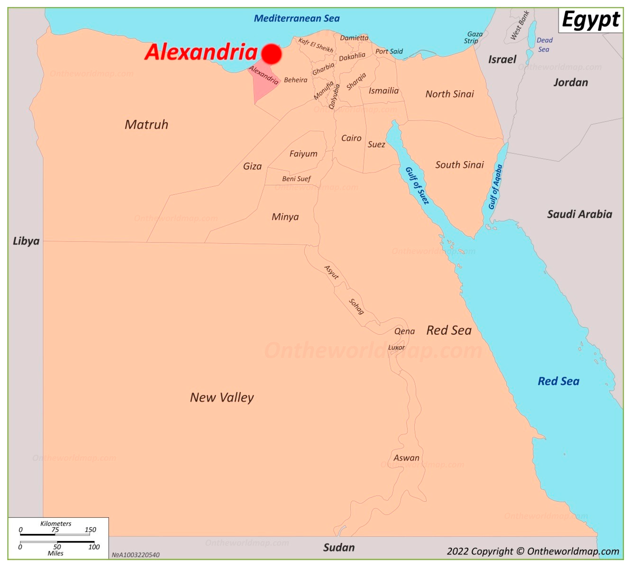
Egypt is located in the northeastern corner of Africa, extending between latitudes 22–31° N and longitudes 24°57′ E to 35°45′ E [10], and is bordered by the Mediterranean Sea to the north. The country is predominantly arid to hyper-arid [11], with most precipitation confined to the northern coastal region during the winter months [4]. This study focuses on Alexandria, a major coastal city located on the northern Mediterranean shore of Egypt at approximately 31.2° N, 29.9° E, as illustrated in Figure 2. Alexandria extends roughly 70 km along the coastline and exhibits a typical Mediterranean climate, characterized by mild, relatively wet winters and hot, predominantly dry summers [1,4]. Its coastal position exposes the city to synoptic-scale weather systems propagating across the Mediterranean Basin, including mid-latitude troughs, surface cyclones, and marine moisture advection from the Mediterranean Sea [12]. The interaction between the warm Mediterranean Sea and the atmosphere enhances low-level moisture availability, modulates boundary-layer thermodynamic processes, and promotes atmospheric instability, particularly during transitional seasons such as late spring and autumn [12]. Furthermore, the flat topography and high degree of urbanization in Alexandria intensify the hydrological response to short-duration, high-intensity rainfall events, increasing the likelihood of rapid surface runoff and localized flooding.
Figure 2.
A map of Egypt, showing the location of Alexandria on the northern coast of Egypt on the Mediterranean Sea.
These combined geographic, climatic, and urban characteristics render Alexandria particularly vulnerable to short-lived but intense convective systems capable of producing heavy rainfall, strong winds, and flash flooding, especially under conditions of anomalous synoptic-scale forcing.
2.2. Data
2.2.1. Reanalysis Data
This study utilizes the ERA5 reanalysis dataset provided by European Centre for Medium-Range Weather Forecasts (ECMWF), along with ERA5-Land products, to investigate the synoptic and dynamic conditions associated with the convective event over Alexandria. These datasets provide a comprehensive range of atmospheric and land-surface variables, offering a robust framework for both synoptic-scale diagnostics and climatological context analysis.
The ERA5 data were retrieved from Copernicus Climate Data Store (CDS), featuring a spatial resolution of 0.25° (~25 km) and hourly temporal resolution, enabling a detailed representation of atmospheric circulation patterns, vertical motion, and surface conditions pertinent to convective development. Key variables extracted for this study include mean sea level pressure (MSLP), geopotential height at 850, 700, and 500 hPa, temperature, relative humidity, horizontal wind components (u, v), and vertical velocity (ω).
To ensure data reliability, selected ERA5 surface variables (temperature and precipitation) were compared with observations from Egyptian Meteorological Authority (EMA) stations in Alexandria. The consistency between reanalysis and station observations supports the suitability of ERA5 for diagnosing the synoptic environment of this event.
In addition, vertically integrated moisture flux convergence (VIMFC) was calculated to quantify low-level moisture supply using pressure-coordinate vertical integration from 1000 to 700 hPa. Positive vorticity advection (PVA) at 500 hPa was also diagnosed to identify regions of dynamically induced ascent ahead of the upper-level trough axis.
In addition to reanalysis data, satellite imagery from geostationary platforms was employed to track cloud formation, convective growth, and storm evolution over the study area. The combination of ERA5 reanalysis and satellite observations provides a complementary dynamical and thermodynamical diagnostic framework for identifying the mechanisms responsible for this rare off-season convective event.
2.2.2. Satellite Imagery
Infrared (IR) imagery from EUMETSAT geostationary platforms (Meteosat series) was employed to monitor cloud cover and convective development, supporting identification of storm initiation and evolution. Deep convective cores were identified using brightness temperature (Tb) thresholds below −60 °C, a widely adopted criterion for detecting intense vertical cloud growth and potential overshooting tops. Hourly IR images were analyzed to capture the temporal evolution of convective initiation, maturation, and decay phases. This satellite-based detection approach was cross-validated with ERA5 vertical velocity (ω) fields at mid-tropospheric levels (e.g., 500 hPa) to ensure dynamical consistency between observed cloud-top cooling and modeled large-scale ascent patterns.
2.2.3. Rainfall Records
Ground-based observations from rain gauges operated by the Egyptian Meteorological Authority (EMA) in Alexandria were used to validate precipitation intensity and spatial distribution. Rainfall data underwent standard quality-control procedures, including outlier detection, internal consistency checks, and comparison with ERA5-Land accumulated precipitation fields. To highlight the anomalous nature of the event, rainfall totals on 31 May 2025 were compared with climatological late-May averages for the period 1981–2010, as well as with two representative non-convective late-May reference days.
The combination of reanalysis, satellite, and in situ observations provides a comprehensive dataset for analyzing the atmospheric mechanisms responsible for this rare off-season convective storm.
2.3. Methods of Analysis
Synoptic analysis of mean sea-level pressure (MSLP) and upper-air fields revealed the presence of well-defined upper-level trough over the eastern Mediterranean, accompanied by a marked decrease in mid- and upper-tropospheric temperatures.
To move beyond descriptive diagnostics quantitative dynamical analyses were applied to assess the dynamical forcing mechanisms driving convective development. Positive vorticity advection (PVA) at 500 hPa was calculated to determine the strength and location of trough-induced ascent. Regions exhibiting strong PVA ahead of the trough axis were interpreted as dynamically favorable zones for upward motion. Vertically integrated moisture flux convergence (VIMFC) was computed to quantify low-level moisture accumulation over northern Egypt, with temporal variations analyzed on an hourly basis to evaluate its contribution to convective initiation. This configuration significantly enhanced atmospheric instability, particularly when combined with elevated moisture content throughout the tropospheric column, as indicated by relative humidity profiles and dew point observations.
Alexandria’s coastal location along the Mediterranean Sea, coupled with relatively high sea surface temperatures (SSTs), provided thermodynamically favorable conditions for deep convection, thereby increasing the potential for rapid vertical development of cumulonimbus clouds.
Upper-level jet stream dynamics at 200 hPa were further examined to identify divergence patterns associated with the right-entrance region of the subtropical jet streak. Divergence fields were analyzed to quantify their contribution to large-scale ascent and to establish the temporal relationship between jet-induced dynamical forcing and peak precipitation intensity.
To emphasize the anomalous nature of the event, derived dynamical and thermodynamical indicators (PVA magnitude, VIMFC, CAPE, and jet divergence) were compared with selected non-convective late-May reference days. This comparative framework enables the identification of diagnostic thresholds for transitional-season convective events over the southeastern Mediterranean.
3. Results
3.1. Climatology
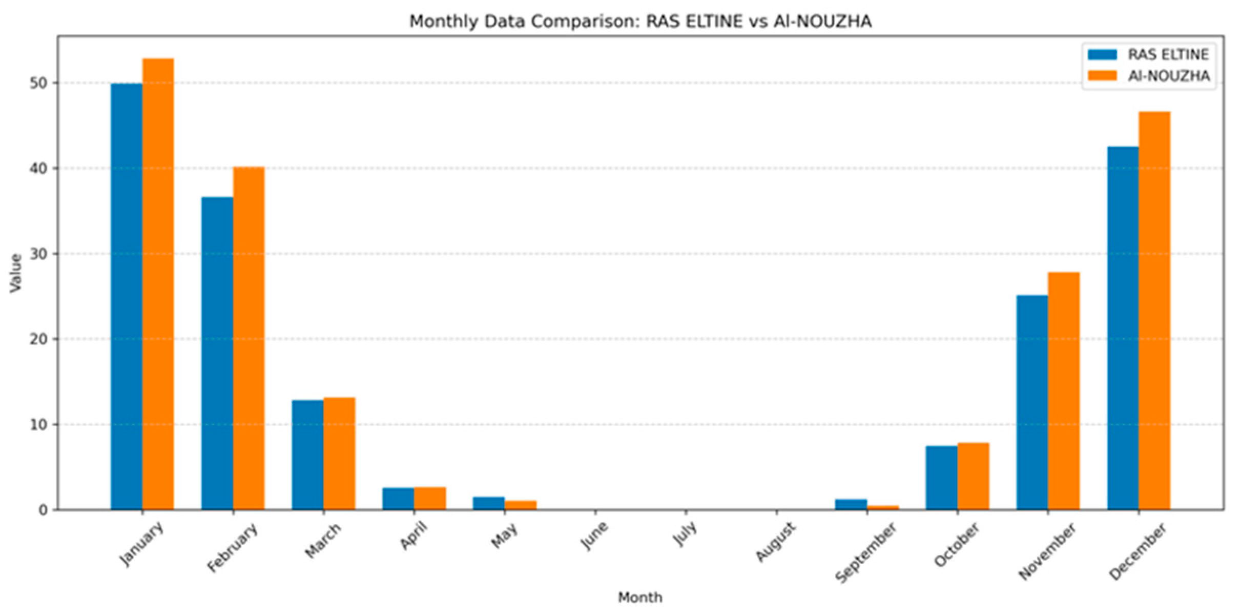
Historical rainfall records from two Egyptian Meteorological Authority (EMA) stations in Alexandria for the period 1981–2010 reveal a well-defined seasonal precipitation cycle. The highest precipitation total occurs during the winter months, particularly from December to February, whereas rainfall decreases sharply from March onward and reaches a minimum during the summer season as shown in Figure 3.
Figure 3.
Monthly mean rainfall (mm) at two meteorological stations in Alexandria during 1980–2010.
The climatological mean rainfall for May is typically below 2 mm, with several years recording no measurable precipitation, reflecting the dominance of stable subtropical conditions during late spring.
A gradual increase in rainfall beginning in October marks the onset of the wet season, highlighting the strong seasonality of Alexandria’s precipitation regime.
To quantitatively assess the anomaly of the 31 May 2025 event, daily rainfall totals were compared with the 1981–2010 climatological mean and standard deviation for May. The recorded rainfall amounts, reaching up to 13 mm at Abu Qir station, exceeded the climatological monthly mean by more than six times and were substantially higher than the 95th percentile of historical late-May observations.
Consequently, convective rainfall events occurring in late spring, such as the 31 May 2025 storm, can be classified as climatologically anomalous within Alexandria’s long-term precipitation record. This statistical deviation confirms that the event was not part of normal seasonal variability but rather was associated with atypical synoptic and thermodynamic forcing mechanisms.
3.2. Synoptic Analysis
The interaction between upper-level dynamical forcing—including positive vorticity advection (PVA) and upper-level divergence—and the relatively warm, moisture-rich marine boundary layer played a critical role in the initiation and maintenance of the convective storm. Positive vorticity advection ahead of the 500 hPa trough axis was quantified using the horizontal vorticity advection term (−V·∇ζ), confirming enhanced cyclonic vorticity transport over northern Egypt between 00:00 and 06:00 UTC.
This dynamical interaction facilitated strong upward motion, with ERA5 vertical velocity (ω) values reaching −0.45 Pa s−1 at 500 hPa, which resulted in localized heavy precipitation over Alexandria.
- (a)
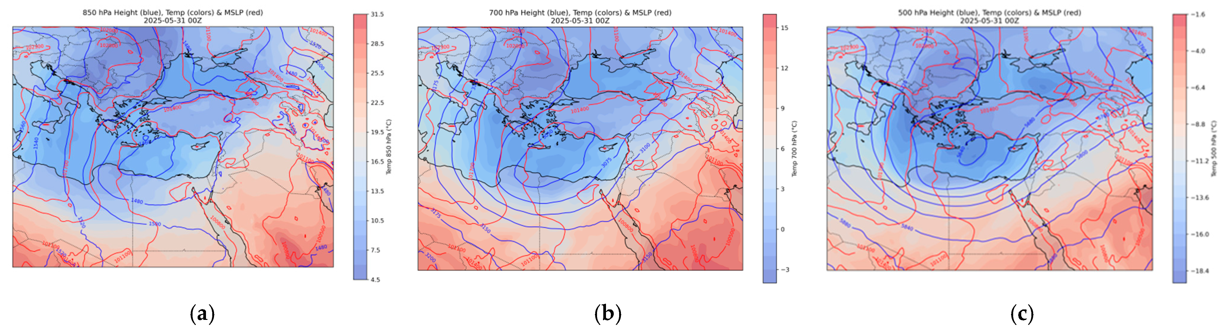
- At 850 hPa, the synoptic pattern is characterized by relatively higher temperatures and enhanced moisture content over the southeastern Mediterranean and northern Egypt. Low-level flow from the Mediterranean Sea transported warm, moist air toward the northern Egyptian coast, increasing boundary-layer humidity and moisture convergence over Alexandria as shown in Figure 4a.Figure 4. Analysis of (a) MSLP and 850 hPa geopotential height with temperature at 850 hPa; (b) MSLP and 700 hPa geopotential height with temperature at 700 hPa; (c) MSLP and 500 hPa geopotential height with temperature at 500 hPa. Temperature is indicated by the color shading gradient shown next to each panel; red lines represent mean sea level pressure (MSLP) contours, and blue lines represent geopotential height contours.
Moisture flux convergence (MFC) was calculated using
where q represents specific humidity and V is the horizontal wind vector. Maximum convergence values were observed between 03:00 and 05:00 UTC directly over Alexandria.
MFC = −∇·(qV)
This low-level thermodynamic configuration played a critical role in destabilizing the atmosphere when combined with colder air aloft. The contrast between warm, moist air at 850 hPa and cooler mid-level temperatures significantly increased convective available potential energy (CAPE), creating a favorable environment for deep convection. Hourly analysis indicates that low-level moisture convergence intensified approximately 2–3 h prior to peak rainfall, highlighting its precursor role in storm initiation.
- (b)
- At 700 hPa, the analysis reveals the continued influence of the upper-level trough over the eastern Mediterranean, accompanied by relatively low geopotential heights and cooler mid-tropospheric temperatures as shown in Figure 4b. Temperature anomalies at this level reached −3 °C relative to the 1981–2010 climatological mean, confirming the presence of anomalous mid-level cooling.
This level represents a critical transition layer for convective development, as mid-tropospheric cooling enhanced thermal instability and reduced vertical stability. Additionally, the presence of moderate moisture, as inferred from temperature and relative humidity fields, supported sustained vertical growth of convective clouds, favoring the development of deep cumulonimbus clouds over the Alexandria coastal region.
- (c)
- At the 500 hPa level, the geopotential height field reveals a pronounced upper-level trough extending over the eastern Mediterranean, with its axis positioned close to northern Egypt. This trough was associated with markedly reduced geopotential heights and a significant decrease in mid-tropospheric temperatures as shown in Figure 4c, as indicated by the temperature shading. Geopotential height anomalies reached approximately −50 to −60 gpm relative to the 1981–2010 climatological mean, confirming the anomalous strength of the trough during late spring. Such cold-air intrusion aloft enhanced the vertical temperature gradient, promoting dynamic instability and increased mid-tropospheric lapse-rate instability.
The presence of cyclonic curvature and increasing positive vorticity ahead of the trough axis contributed to large-scale ascent, providing a crucial upper-level forcing mechanism for convective initiation over Alexandria during the early hours of 31 May 2025. Positive vorticity advection (PVA) was diagnosed using the horizontal advection term (−V·∇ζ), with maximum values observed between 00:00 and 06:00 UTC over northern Egypt.
Spatial correspondence between regions of enhanced PVA and ERA5-derived upward vertical velocity (ω reaching approximately −0.4 to −0.5 Pa s−1) indicates strong dynamical coupling between vorticity forcing and vertical motion. Time evolution analysis further shows that peak mid-level vorticity advection preceded the maximum rainfall intensity by approximately 1–2 h, reinforcing its role as a key dynamical trigger in the storm development process.
- Relative Humidity Distribution (850–500 hPa)
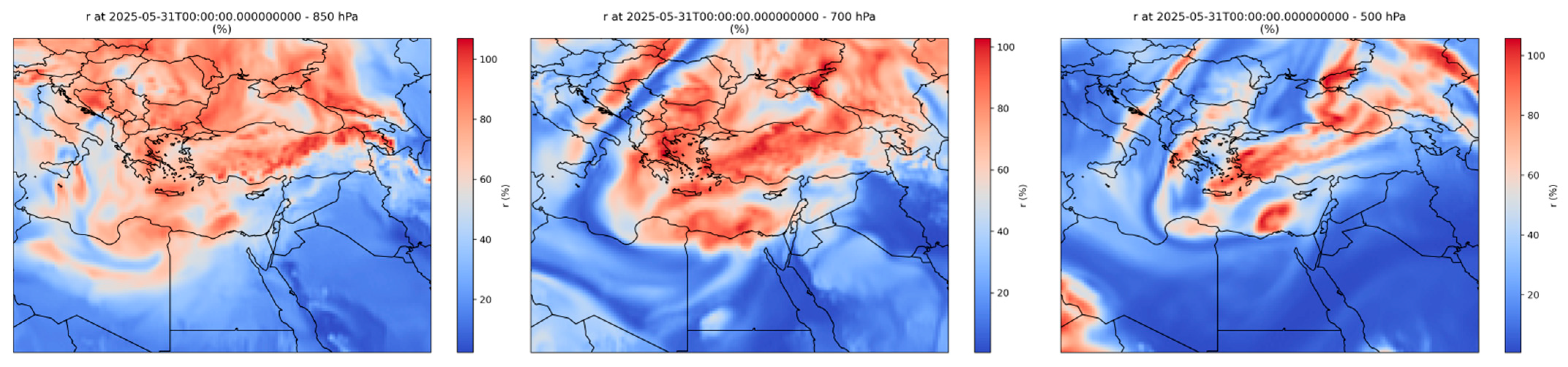
Relative humidity fields indicate a deep moist layer extending from the lower troposphere (850 hPa) into the mid-troposphere (500 hPa) over the eastern Mediterranean and northern Egypt as illustrated in Figure 5.
Figure 5.
Vertical distribution of relative humidity at 850, 700, and 500 hPa over northern Egypt, valid at 00 UTC on 31 May 2025. The legend indicates relative humidity values from 0 to 100%, with red colors representing the highest humidity and blue colors representing the lowest humidity.
At 850 hPa, relative humidity values exceeded approximately 75–80% during the pre-convective phase (00:00–03:00 UTC), reflecting enhanced marine moisture transport from the Mediterranean Sea toward the northern Egyptian coast. High humidity at this level represents a strong low-level moisture supply, while moderate to high humidity at 500 hPa reduced entrainment of dry air into ascending parcels, thereby maintaining favorable conditions for convection.
Between 700 and 500 hPa, relative humidity remained in the range of 60–70%, indicating the absence of significant mid-level dry air intrusion. This vertically coherent moisture distribution supported efficient cloud growth and precipitation processes, enhancing the intensity of rainfall associated with the convective storm.
Temporal analysis shows that deep-layer moisture increased several hours prior to the peak rainfall intensity, suggesting that moisture accumulation acted as a precursor to convective intensification.
The combined presence of strong low-level moisture supply and sustained mid-level humidity enhanced precipitation efficiency by minimizing evaporative cooling and maintaining parcel buoyancy during ascent.
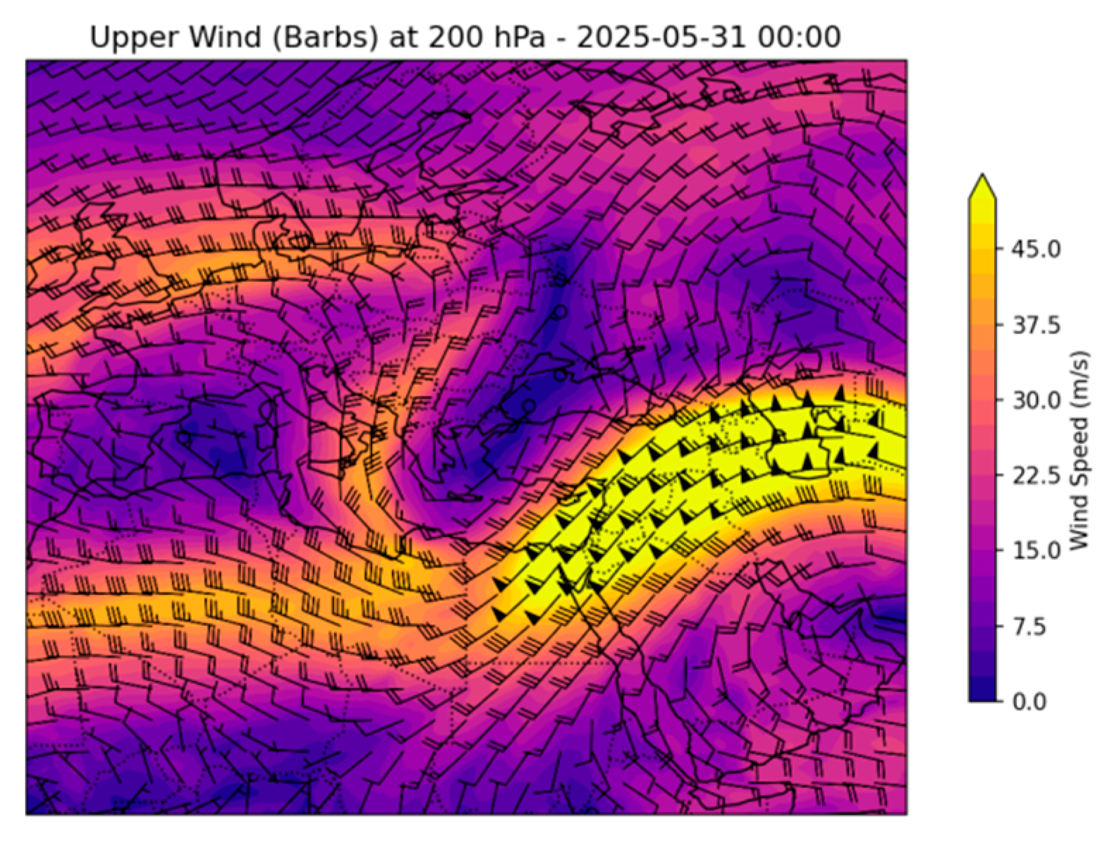
At the 200 hPa level, the upper-tropospheric flow was dominated by well-defined subtropical jet stream extending across the eastern Mediterranean as shown in Figure 6. Jet core wind speeds exceeded 40 m s−1, with Alexandria positioned within the right-entrance region of the jet streak between 00:00 and 06:00 UTC.
Figure 6.
Upper-tropospheric jet stream at 200 hPa over the eastern Mediterranean at 00 UTC on 31 May 2025.
The curved jet stream setup was located to the north of Alexandria, placing the study area within the downwind half of the curved jet streak, which is dynamically favorable upward vertical motion. According to quasi-geostrophic theory, geostrophic circulations promote divergence aloft and ascent below. The resulting upper-level divergence acted to evacuate mass from the upper troposphere, reinforcing surface pressure falls and promoting sustained ascent throughout the atmospheric column. ERA5-derived horizontal divergence values at 200 hPa reached approximately 2–3 × 10⁻⁵ s−1 over northern Egypt during the peak development phase of the storm.
The coupling between jet-induced divergence at 200 hPa and the underlying mid-level trough substantially enhanced large-scale ascent over northern Egypt. In particular, the downstream side of the curved jet streak at 200 hPa typically produces vertical motion as part of ageostrophic adjustments, further reinforcing upward motion over the region.
Time-series analysis indicates that maximum upper-level divergence occurred approximately one hour prior to peak rainfall intensity, suggesting a dynamical triggering role of the jet in convective initiation. When combined with increased low-level moisture and pronounced thermal instability, this upper-level forcing played a pivotal role in initiating and sustaining deep convection over Alexandria during the early morning hours of 31 May 2025. The jet stream thus acted as a key dynamical driver, linking upper-tropospheric circulation anomalies to the observed short-lived, high-impact convective storm. This vertical coupling between jet-induced divergence at 200 hPa, positive vorticity advection at 500 hPa, and moisture flux convergence at 850 hPa formed a dynamically coherent ascent structure, explaining the rapid intensification of the convective system.
- Thermodynamic Structure (Skew-T Diagrams)
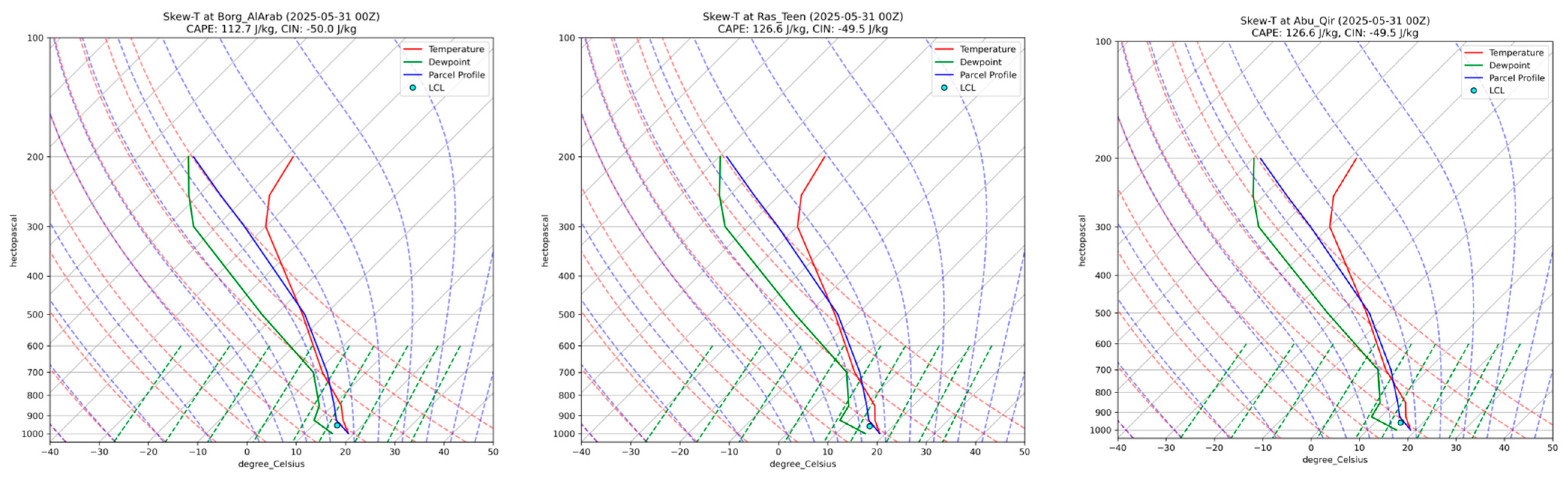
Skew-T for some areas in Alexandria including Abu Qir (31.32° N, 30.06° E), Borg El Arab (31.17° N, 29.86° E), and Ras El Tin (31.21° N, 29.88° E) illustrate a thermodynamically unstable atmospheric profile during the 31 May 2025 convective event as shown in Figure 7. The soundings indicate moderate convective available potential energy (CAPE ≈ 120–130 J kg−1) and relatively weak convective inhibition (CIN ≈ −50 J kg−1), suggesting that only limited lifting was required to initiate convection. Although CAPE values were not extremely high, the presence of strong upper-level dynamical forcing compensated for the moderate instability, favoring convective development.
Figure 7.
Skew-T diagrams of Borg El Arab, Ras El-Tin, and Abu Qir, valid at 00 UTC on 31 May 2025.
Lifted Condensation Level (LCL) heights were relatively low (~850–900 hPa), and the Level of Free Convection (LFC) was reached with minimal mechanical lifting. The relatively low LCL indicates a moist boundary layer, which enhances cloud base formation and precipitation efficiency.
The close proximity of temperature and dew point curves in the lower troposphere confirms high moisture availability, while the parcel ascent profiles demonstrate favorable conditions for deep convective development. The vertical temperature profile also exhibits a notable increase in lapse rate between 850 and 500 hPa, consistent with mid-level cooling associated with the upper-level trough.
The temporal consistency between thermodynamic instability parameters and peak dynamical forcing (PVA and jet divergence) further supports the interpretation that convection resulted from the combined effects of thermodynamic and dynamic processes. These thermodynamic characteristics are consistent with the observed short-lived but intense thunderstorm activity over Alexandria during the early hours of 31 May 2025.
- Overall Synoptic and Dynamic Interpretation
The convective event of 31 May 2025 over Alexandria resulted from a synergistic interaction between upper-level dynamical forcing and low-level thermodynamic instability. A pronounced upper-level trough introduced cold air aloft and enhanced positive vorticity, promoting large-scale ascent and destabilization of the atmospheric column. Geopotential height anomalies at 500 hPa reached approximately −50 to −60 gpm relative to the climatological mean, indicating that the trough was dynamically anomalous for the late spring season. Relatively warm sea surface temperatures and persistent moisture transport from the Mediterranean Sea increased low-level humidity and convective available potential energy (CAPE). Moisture flux convergence at 850 hPa intensified during the pre-convective phase (00:00–03:00 UTC), contributing to boundary-layer moistening and atmospheric preconditioning prior to storm initiation.
The vertical alignment of dynamic lifting associated with the upper-level trough and subtropical jet stream, combined with enhanced thermal instability and deep-layer moisture availability, facilitated the rapid development of cumulonimbus clouds. Upper-level divergence within the right-entrance region of the subtropical jet (200 hPa divergence ≈ 2–3 × 10⁻⁵ s−1) dynamically coupled with mid-level positive vorticity advection and low-level moisture convergence, forming a vertically coherent ascent structure over northern Egypt. This configuration led to intense rainfall, frequent lightning, and localized hail over the Alexandria metropolitan area.
Temporal consistency between peak upper-level forcing and maximum rainfall intensity further confirms the dynamical triggering role of the jet–trough interaction. Such a synoptic configuration highlights the potential for short-lived yet high-impact convective storms over the southeastern Mediterranean during transitional seasons, even outside the climatological rainy period.
The diagnostic parameters identified in this study suggest that combined thresholds of enhanced 500 hPa vorticity forcing, 200 hPa jet-induced divergence, strong 850 hPa moisture flux convergence, and CAPE values exceeding 100 J kg−1 may serve as practical indicators for the early detection of similar off-season convective events.
- Rainfall
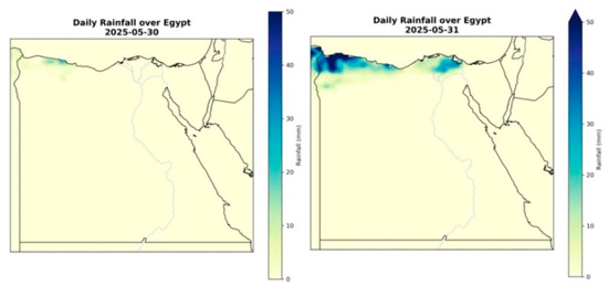
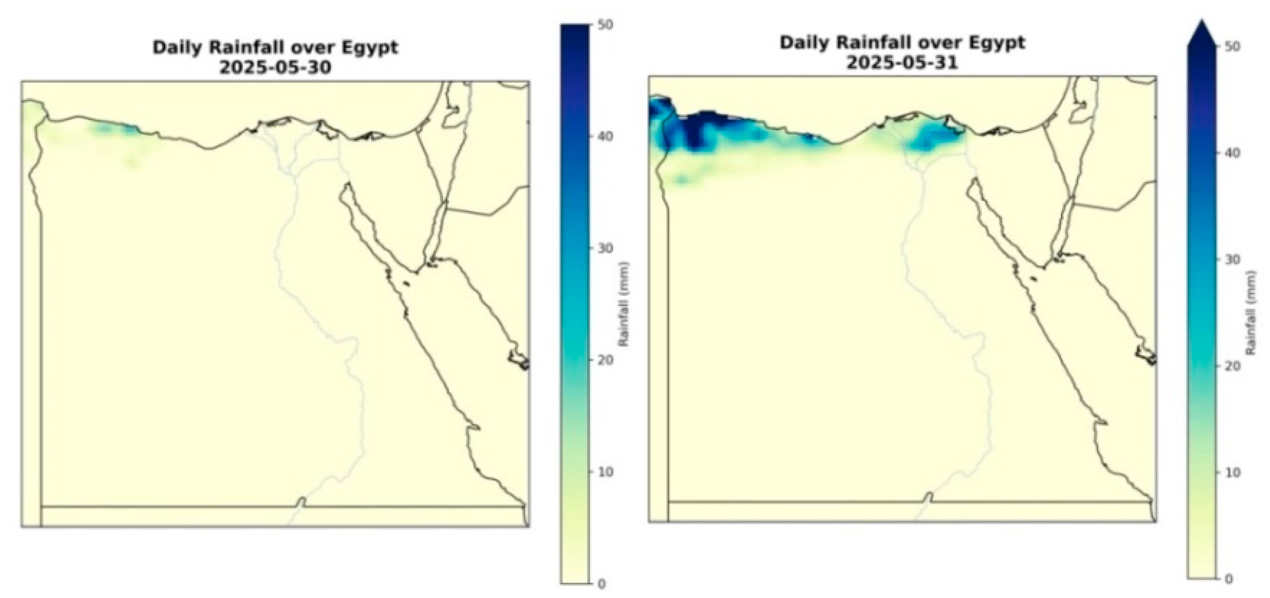
On 30 May 2025, rainfall activity was primarily confined to western Egypt and the northwestern Mediterranean coastal regions, with light to moderate precipitation amounts indicating the initial phase of the synoptic system affecting the country. Daily accumulated rainfall totals generally remained below 10 mm, with most areas over Egypt experiencing little to no measurable precipitation.
By 31 May 2025, the rainfall field exhibited a pronounced eastward expansion and intensification along the Mediterranean coast, with substantially higher precipitation totals affecting the northern coastal areas, including Alexandria. Accumulated daily rainfall exceeded 20–30 mm along parts of the northwestern coast as shown in Figure 8, while values over and around Alexandria were estimated at approximately 15–25 mm based on ERA5-Land data. This evolution reflects the continued development and eastward propagation of the associated atmospheric disturbance.
Figure 8.
Daily accumulated rainfall (mm) from ERA5-Land over Egypt on 30 and 31 May 2025.
The spatial gradient in rainfall intensity from west to east along the Mediterranean coast indicates the progressive strengthening of the synoptic-scale system as it approached northern Egypt. Overall, the temporal progression of rainfall from 30 to 31 May 2025 demonstrates that the precipitation event over Alexandria resulted from a gradually evolving large-scale weather system, rather than a localized or short-lived phenomenon. The ERA5-Land dataset effectively captures this spatiotemporal evolution, emphasizing its suitability for analyzing rainfall-producing systems over North Africa and the eastern Mediterranean.
4. Observations
4.1. Rainfall Observations
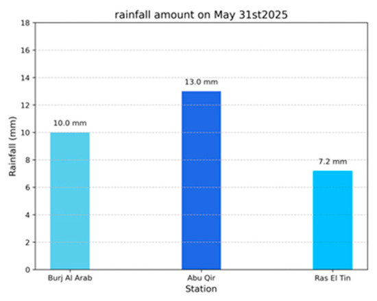
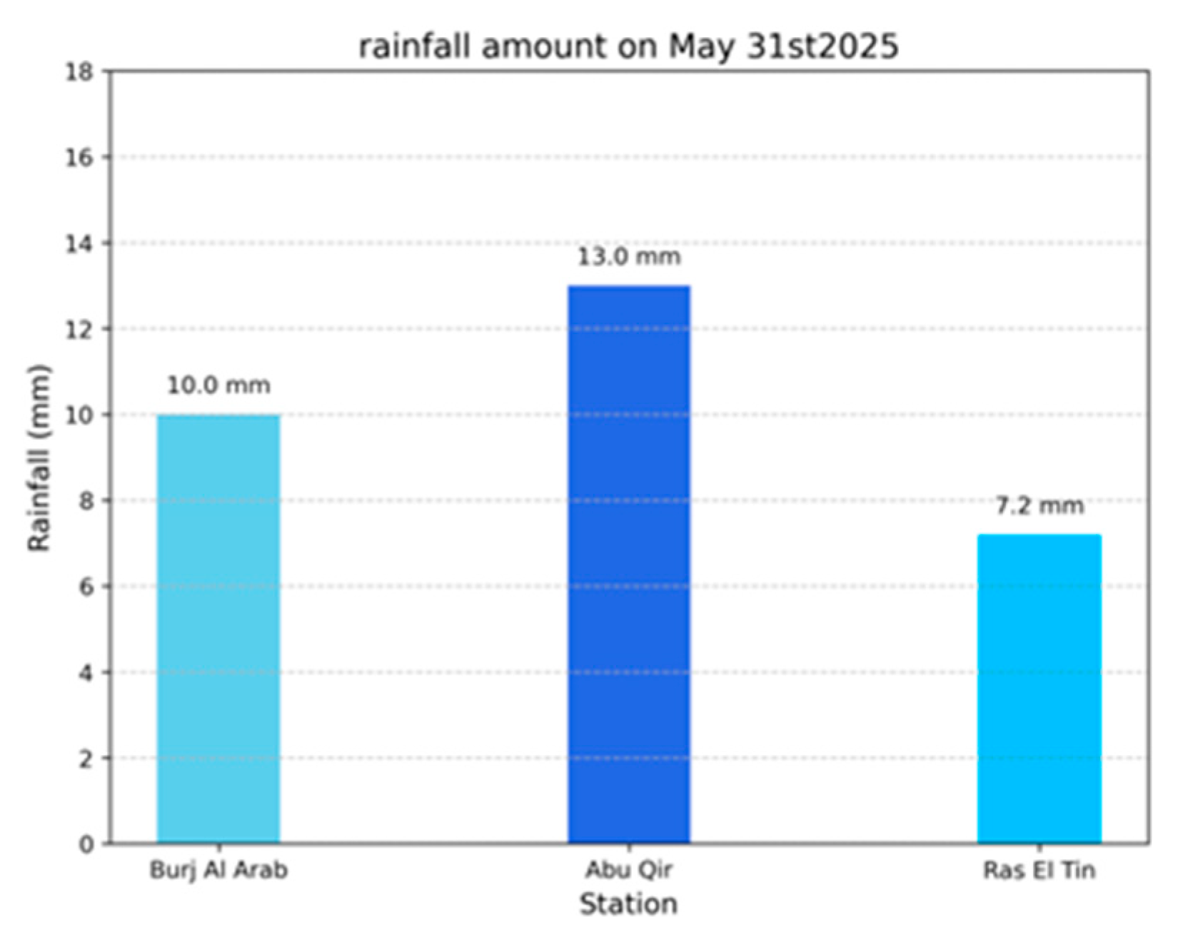
Rainfall measurements from three meteorological stations in Alexandria on 31 May 2025 indicate the occurrence of a short-duration convective event, characterized by intense precipitation over a limited spatial extent.The highest recorded rainfall reached 13.0 mm at Abu Qir, followed by 10.0 mm at Borg El Arab and 7.2 mm at Ras El Tin as shown in Figure 9.
Figure 9.
Recorded daily rainfall amounts (mm) at three meteorological stations—Ras El-Tin, Borg El Arab, and Abu Qir—during the convective storm on 31 May 2025.
These values substantially exceed the climatological averages for late May, which are typically below 2 mm, underscoring the anomalous nature of this off-season rainfall event. In particular, the recorded total at Abu Qir was more than six times the long-term monthly mean for May (1981–2010), highlighting the statistical extremity of the event within the late-spring climatological context. The majority of the precipitation occurred during the early morning hours, reflecting the high intensity and abrupt onset of the convective storm. Hourly observations indicate that rainfall intensity peaked within a relatively short time window (approximately 03:00–06:00 UTC), consistent with the timing of maximum upper-level divergence and mid-level vorticity advection identified in the synoptic analysis.
The spatial variability among the three stations further suggests a localized convective structure, typical of mesoscale thunderstorm systems, rather than uniform stratiform precipitation.
4.2. Satellite IR Observations
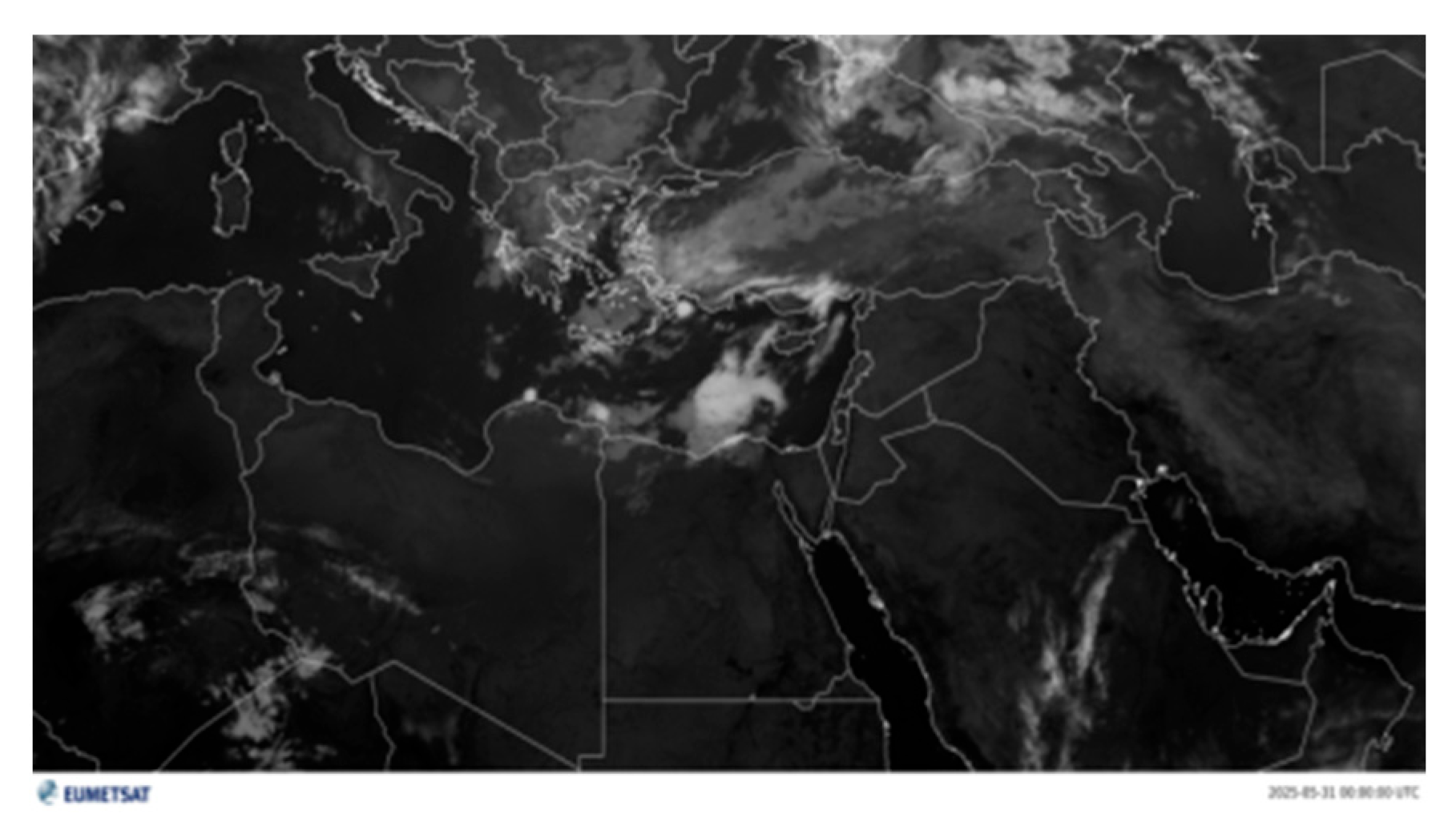
Infrared (IR) satellite imagery from geostationary platforms reveals the rapid initiation and localized development of deep convective clouds over the Alexandria metropolitan area during the early hours of 31 May 2025 as shown in Figure 10.
Figure 10.
Infrared (IR) satellite image showing convective cloud development over Alexandria and the eastern Mediterranean at 00:00 UTC on 31 May 2025.
The observed very cold cloud-top temperatures indicate vigorous vertical cloud growth, consistent with the presence of deep cumulonimbus clouds. Cloud-top brightness temperatures decreased to approximately −55 °C to −65 °C during the mature stage of the storm, suggesting strong updraft intensity and deep tropospheric penetration. The compact spatial extent and short lifetime of the convective system evident in the IR imagery further support the classification of this event as a short-lived but high-impact convective storm. The most pronounced cloud-top cooling occurred between approximately 03:00 and 05:00 UTC, coinciding with peak rainfall intensity and maximum upper-level dynamic forcing identified in the synoptic analysis.
The rapid development and subsequent dissipation observed in the IR sequence are characteristic of mesoscale convective cells triggered under dynamically enhanced but thermodynamically moderate instability conditions.
5. Conclusions
The synoptic and thermodynamic analyses demonstrate that the rare convective storm affecting Alexandria on 31 May 2025 was primarily driven by the interaction between a pronounced upper-level trough and warm, moisture-rich air advected from the Mediterranean Sea. Geopotential height anomalies at 500 hPa (−50 to −60 gpm), diagnosed positive vorticity advection, and enhanced jet-induced divergence at 200 hPa collectively indicate that the event was dynamically anomalous for the late-spring season. Elevated sea surface temperatures enhanced atmospheric instability and contributed to the rapid development of deep cumulonimbus clouds. Strong low-level moisture flux convergence at 850 hPa, combined with moderate CAPE values (≈120–130 J kg−1) and weak convective inhibition, provided favorable thermodynamic preconditioning for deep convection. The combined effects of upper-level dynamic forcing and favorable low-level thermodynamic conditions resulted in intense, short-duration rainfall accompanied by lightning and thunder.
Temporal consistency between peak upper-level forcing and maximum rainfall intensity confirms the critical role of vertical dynamical coupling in storm intensification.
This event highlights the susceptibility of coastal urban areas such as Alexandria to high-impact convective storms occurring outside the climatological rainy season. The statistical deviation of observed rainfall totals from the May 1981 to 2010 climatology further emphasizes the anomalous character of this off-season event. The findings underscore the importance of incorporating upper-level circulation features, air–sea interactions, and convective instability indicators into forecasting and early warning systems to improve preparedness and reduce the impacts of off-season extreme weather events. In particular, diagnostic thresholds identified in this study—such as enhanced 500 hPa vorticity forcing, 200 hPa jet divergence exceeding ~2 × 10⁻⁵ s−1, strong 850 hPa moisture flux convergence, and CAPE values above 100 J kg−1 during late spring—may serve as practical indicators for early detection of anomalous convective activity over the southeastern Mediterranean.
Author Contributions
Conceptualization, M.M.L. and Z.S.; methodology, M.M.L. and Z.S.; software, F.R.A.I.; validation, M.M.L., Z.S. and M.E.H.; formal analysis, M.M.L.; investigation, M.M.L., Z.S. and M.E.H.; resources, M.M.A.W. and F.R.A.I.; data curation, Z.S. and M.E.H.; writing—original draft preparation, M.M.L.; writing—review and editing, Z.S., F.R.A.I., M.M.A.W. and M.E.H.; visualization, F.R.A.I.; supervision, M.M.A.W. All authors have read and agreed to the published version of the manuscript.
Funding
This research received no external funding.
Institutional Review Board Statement
Not applicable.
Informed Consent Statement
Not applicable.
Data Availability Statement
The original data presented in the study are openly available in ERA5 and ERA5-Land websites.
Conflicts of Interest
The authors declare no conflict of interest.
References
- IPCC. Climate Change 2021: The Physical Science Basis. Extreme Precipitation Events and Their Impacts; Cambridge University Press: Cambridge, UK; New York, NY, USA, 2021. [Google Scholar]
- Lou, B. Extreme Weather Events under Climate Change: Socioeconomic Impacts and Risk Management. Contemp. Educ. Front. 2025, 3, 157–163. [Google Scholar] [CrossRef] [Scilit]
- Akinsanola, A.A.; Singhai, P.; Taguela, T.N.; Folorunsho, A.H.; Adeyeri, O.E.; Morakinyo, T.E.; Adebiyi, A.A. A Review of Urban Resilience to Weather and Climate Extremes. City Built Environ. 2025, 3, 24. [Google Scholar] [CrossRef] [Scilit]
- Seager, R.; Osborn, T.J.; Kushnir, Y.; Simpson, I.R.; Nakamura, J.; Liu, H. Climate Variability and Change of Mediterranean-Type Climates. J. Clim. 2019, 32, 2887–2915. [Google Scholar] [CrossRef] [Scilit]
- Angelidou, A. Convective Environments Along Mediterranean Cyclone Tracks: Exploring Severe Surface Weather. Master’s Thesis, University of Bern, Bern, Switzerland, 2023. [Google Scholar]
- Pedersen, A.N.; Mikkelsen, P.S.; Arnbjerg-Nielsen, K. Climate Change-Induced Impacts on Urban Flood Risk Influenced by Concurrent Hazards. J. Flood Risk Manag. 2012, 5, 203–214. [Google Scholar] [CrossRef] [Scilit]
- Fowler, H.J.; Wasko, C.; Prein, A.F. Intensification of Short-Duration Rainfall Extremes and Implications for Flood Risk: Current State of the Art and Future Directions. Philos. Trans. A Math. Phys. Eng. Sci. 2021, 379, 20190541. [Google Scholar] [CrossRef] [Scilit] [PubMed]
- Portal, A.; Angelidou, A.; Rousseau-Rizzi, R.; Raveh-Rubin, S.; Givon, Y.; Catto, J.L.; Battaglioli, F.; Taszarek, M.; Flaounas, E.; Martius, O. Convective Environments Within Mediterranean Cyclones. Atmos. Sci. Lett. 2025, 26, e1234. [Google Scholar] [CrossRef] [Scilit]
- Valencia, J.A.R.; Gonzalez, J.R.P.; Granados, G.R.S.; Valencia, J.D.R. Early Warning System on Extreme Weather Events for Disaster Risk Reduction. Rev. Fac. Ing. Univ. Antioq. 2019, 92, 96–104. [Google Scholar] [CrossRef] [Scilit]
- Mahmoud, A.H.A. An Analysis of Bioclimatic Zones and Implications for Design of Outdoor Built Environments in Egypt. Build. Environ. 2011, 46, 605–620. [Google Scholar] [CrossRef] [Scilit]
- Mohamed, M.A.E.-H.; Darrag, M.H.; Ahmed, M.A.; El-Mahdy, M.E.-S. Spatiotemporal Assessment of Daily Temperature Extremes in Egypt during 1980–2023. Sci. Afr. 2025, 29, e02850. [Google Scholar] [CrossRef] [Scilit]
- Khodayar, S.; Kushta, J.; Catto, J.L.; Dafis, S.; Davolio, S.; Ferrarin, C.; Flaounas, E.; Groenemeijer, P.; Hatzaki, M.; Hochman, A.; et al. Mediterranean Cyclones in a Changing Climate: A Review on Their Socio-Economic Impacts. Rev. Geophys. 2025, 63, e2024RG000853. [Google Scholar] [CrossRef] [Scilit]


Disclaimer/Publisher’s Note: The statements, opinions and data contained in all publications are solely those of the individual author(s) and contributor(s) and not of MDPI and/or the editor(s). MDPI and/or the editor(s) disclaim responsibility for any injury to people or property resulting from any ideas, methods, instructions or products referred to in the content. |
© 2026 by the authors. Licensee MDPI, Basel, Switzerland. This article is an open access article distributed under the terms and conditions of the Creative Commons Attribution (CC BY) license.