


Abstract
The A* algorithm is widely adopted across agriculture, robotics, and GPS navigation for efficient route planning, yet it faces challenges in balancing search efficiency with path quality. To address these limitations, we introduce Octile–Annealed, a novel heuristic that augments the classic Octile distance with a distance-dependent annealing weight. Specifically, Octile–Annealed scales the Octile metric by a smooth function of the current node’s Euclidean distance to the final location, yielding a heuristic that is gentle near the target and more directive when far away. This design retains the geometric fidelity of Octile, accelerates search convergence in open regions, and preserves guidance in constrained corridors. Beyond discrete planning, we incorporate adaptive Bézier smoothing to post-process the grid path into a collision-free, curvature-friendly trajectory. This is particularly relevant in agricultural environments (e.g., orchard rows and cross-aisles), where machines must follow efficient routes without abrupt turns that could slow operations or risk crop damage. We benchmark Octile–Annealed against three established baselines—Euclidean and Octile—on orchard-like grids of varying sizes and obstacle patterns. The results show that Octile–Annealed consistently reduces computation time while maintaining competitive raw path lengths and producing short, smooth Bézier trajectories. Overall, the proposed heuristic enhances A*’s operational efficiency and route quality, making it well-suited for complex, structured agricultural layouts and for general navigation tasks that benefit from smooth post-processing. However, it must be acknowledged that these comparative performance metrics are strictly limited to simulated grid cases; consequently, comprehensive validation using actual field data remains necessary to fully confirm their practical applicability under real-world agricultural conditions.
1. Introduction
The A* algorithm has been a foundational tool in autonomous navigation planning for decades, with demonstrated utility across robotics, satellite-based navigation, and agricultural automation. Its enduring appeal stems from a principled best-first search that reliably delivers shortest paths under practical constraints, making it a default choice when repeatable, high-precision navigation is required. In both urban autonomy and field operations, practitioners value A* for its robustness on complex maps and its predictable real-time behavior supported by admissible and, in many deployments, consistent heuristics [1,2,3,4] Notwithstanding these strengths, A* exhibits two persistent limitations that become salient in demanding settings. First, search efficiency degrades as the algorithm expands large frontiers, especially when the heuristic underestimates cost or poorly reflects traversability, inflating node expansions and latency—an impediment for time-critical systems. Second, the geometric quality of grid-optimal solutions can be inadequate for vehicles with kinematic and dynamic constraints: discretization often induces staircase segments and abrupt heading changes that are suboptimal for wheeled platforms, increase control effort, and reduce throughput in the field. These issues motivate refined heuristics and post-processing methods that better encode motion costs and environmental structure, aiming to reduce expansions while producing curvature-friendly, execution-ready trajectories suitable for real agricultural deployments [5,6,7,8].
Advancing A* is key to realizing its full value in agriculture. The central objectives are twofold: producing paths that are easier to execute and making the search behave robustly in demanding field layouts. Ongoing work refines the baseline planner with targeted extensions and careful modifications so it remains a practical choice for modern farm operations. A primary concern is path smoothness. Trajectories with fewer heading changes and gentler curvature reduce stress on implements, lower the likelihood of crop damage, and keep machines moving efficiently. Equally important is adaptability to difficult ground—irregular terrain, dense obstacles, and alternating row and cross-aisle patterns. To address these conditions, recent approaches design hybrid heuristics that blend complementary distance measures, improving guidance without sacrificing the guarantees that make A* reliable [9,10,11]. These refinements align directly with the goals of precision agriculture, where consistent, accurate navigation under tight operational constraints enables tasks such as planting, spraying, and harvesting to be carried out with minimal waste. Optimized routes translate into shorter mission times, smoother motion, and more predictable vehicle behavior. The benefits extend beyond productivity. More efficient planning reduces unnecessary traversal and engine load, tightening fuel use and operating hours. As farms seek to curb emissions and conserve resources, improvements in path quality and search efficiency contribute to more sustainable practices across the entire production cycle [12,13,14,15,16].
In agricultural deployments, path planning is not limited to idealized row-and-crossing layouts. Field robots often operate in semi-structured and partially unstructured environments characterized by local slopes, soil undulations, deformable ground, wheel-slip risk, and discontinuities caused by vegetation growth or field-maintenance conditions. Such factors directly influence traversability, motion stability, localization accuracy, and ultimately the safety and reliability of autonomous operation, particularly in off-road and orchard-like settings where terrain structure and surface quality vary significantly. In addition, agricultural robotic platforms typically rely on embedded computing systems with limited processing power and memory resources, making computational efficiency and real-time responsiveness essential design requirements for practical field deployment. This is especially important in applications that require repeated replanning, online obstacle avoidance, or integration with local navigation modules and perception pipelines. Beyond geometric path optimality, agricultural navigation must also account for operational requirements such as smooth motion execution, reduced steering effort, energy efficiency, crop-safe maneuvering, and high field productivity [17,18,19,20,21]. Despite these practical requirements, existing A*-based improvements in the literature often emphasize either search acceleration or path smoothing in isolation, without addressing their joint effectiveness under the computational and operational constraints of semi-structured agricultural environments. As a result, a research gap remains in the development of a path-planning framework that simultaneously improves search efficiency, trajectory smoothness, and practical suitability for embedded agricultural robotic platforms operating in field and orchard-like terrains. To address this gap, the present work introduces a distance-dependent Octile-based heuristic combined with Bézier-based post-processing, aiming to improve computational efficiency while producing smoother and more operationally suitable trajectories for agricultural robotic navigation.
The primary objective of this study is to enhance the geometric and practical quality of the trajectories produced by the A* algorithm, while at the same time optimizing its computational performance:
- We propose Octile–Annealed, a new heuristic that augments the classical Octile distance with a smoothly distance-dependent weight based on the node’s Euclidean distance to the goal. The heuristic remains conservative near the target and becomes more directive when far away, enabling faster convergence in open regions while preserving stable guidance in narrow corridors. Octile faithfully captures grid motion with diagonal moves, and the annealing term adapts the level of search aggressiveness to local spatial context.
- To improve the geometric quality of the final routes, we apply adaptive Bézier smoothing as a post-processing step. This produces continuous, collision-free, curvature-friendly trajectories—particularly valuable in agricultural fields with rows and cross-aisles, where gentle turning reduces equipment stress and mitigates crop damage.
- We evaluate the method on agricultural-style grid maps of varying sizes and obstacle layouts under rural simulation conditions. Results show that Octile–Annealed consistently reduces computation time, maintains competitive raw path lengths, and yields short, smooth trajectories after smoothing. The proposed heuristic enhances both the process optimization and routing quality of A*, making it well suited to complex, structured agricultural scenes and other navigation tasks that benefit from smooth end-to-end motion.
The remainder of this paper is structured as follows. Section 2 surveys the prior work that underpins our study in agricultural environments. Section 3 details the proposed optimization of the A* algorithm tailored to field and orchard-like settings. Section 4 presents the experimental setup and results on agricultural grid layouts. Section 5 discusses the solution framework, emphasizing its practical implications and key advantages for farm-robot navigation. Finally, Section 6 concludes the paper by outlining the principal findings in the context of agriculture.
2. Related Work
Research efforts continue to reshape A* in order to support smoother and more adaptable motion over challenging terrain. Current efforts span distance-dependent (annealed) heuristics, obstacle- and density-sensitive weighting, and curvature or turn-penalty terms that better reflect vehicle kinematics. Complementary strategies—such as adaptive Bézier smoothing, local replanning with sensor feedback, and cost maps encoding soil conditions or crop-row geometry—address the realities of agricultural operation: narrow rows, uneven soils, ruts, and cluttered headlands. Collectively, these advances reduce node expansions, curtail detours, and mitigate grid-induced staircase artifacts, yielding trajectories that are more compatible with robotic hardware and more consistent with practical field-driving requirements [22,23,24,25]. The broader objective of these developments is to support precision agriculture at field scale through more efficient, robust, and execution-aware navigation. Smoother paths and more informative heuristics reduce fuel and battery consumption, shorten time-to-task, reduce soil compaction from aggressive steering, and improve repeatability under GNSS drift or partial occlusions. By producing routes with fewer reversals, bounded curvature, and rapid recovery from disturbances, autonomous vehicles and agricultural robots traverse fields more efficiently and reliably—meeting tight latency budgets while maintaining safety and crop protection [26,27,28].
A fundamental line of research concerns the optimization of the traditional A* framework itself. Although classical A* remains one of the most widely adopted graph-search algorithms in robotics due to its determinism, completeness, and straightforward implementation, its practical limitations are well documented. In large search spaces or environments with weakly informative heuristics, the algorithm may expand an excessive number of nodes, leading to increased latency and memory consumption. Moreover, grid-based shortest paths often contain abrupt directional changes that are suboptimal for physical robot execution. To address these issues, a broad body of work has proposed improvements to the heuristic evaluation function, node-expansion policy, search direction, and cost structure of the original algorithm. These include adaptive weighting strategies, bidirectional search mechanisms, obstacle-sensitive heuristic adjustment, and hybrid formulations that seek to reduce redundant exploration while preserving satisfactory path quality. Such studies constitute the theoretical foundation for many contemporary A*-based planners and are directly relevant to real-time robotic navigation, particularly when computational resources are constrained [29,30].
A second major research direction extends path planning beyond idealized planar occupancy maps toward terrain-aware and three-dimensional formulations. This extension is particularly important in agricultural and off-road robotics, where route feasibility depends not only on obstacle avoidance but also on slope, elevation variation, soil deformability, terrain roughness, and local traversability conditions. In such environments, the shortest geometric path may not correspond to the safest, most stable, or most energy-efficient route. Consequently, recent studies have incorporated elevation models, terrain descriptors, obstacle-density information, and vehicle–terrain interaction criteria into the planning process in order to better capture the physical characteristics of the operating environment. These approaches demonstrate that navigation performance must be evaluated in relation to terrain morphology and motion feasibility, rather than solely in terms of abstract path length on flat grids [31,32,33].
A third important direction combines global path planning with perception-driven environment updates, SLAM, and online path replanning. In practical agricultural deployments, navigation rarely takes place on perfectly known and static maps. Instead, robots may encounter temporary obstacles, partial occlusions due to vegetation, localization drift, missing map information, or changes in field accessibility caused by weather, machinery, or operational activity. Under such conditions, a planner must do more than compute an initial global route; it must also support route adaptation as new environmental information becomes available. For this reason, a growing body of research integrates path planning with SLAM pipelines, local obstacle sensing, and dynamic replanning modules. These systems improve operational robustness by preserving global navigation objectives while allowing the robot to react to uncertainty, environmental change, and perception updates in real time [34,35].
Within agricultural robotics, these research directions acquire additional significance because navigation quality directly affects operational efficiency, crop safety, and machine durability. Unlike many indoor or highly structured robotic scenarios, agricultural environments combine repetitive geometric structure with local irregularity: crop rows may appear orderly at the global level, yet field access corridors, headland turns, vegetation density, and soil conditions can introduce substantial local complexity. As a result, path planning for agricultural robots must simultaneously support directional efficiency over long row segments, maneuverability in constrained passages, and smooth trajectory generation that limits steering effort and unintended crop disturbance. This dual requirement explains why recent agricultural navigation studies often combine improved global planning with trajectory smoothing, terrain-sensitive cost modeling, or local replanning mechanisms [36,37,38].
The study in [39] introduces an optimized formulation of the A* to improve path planning for mobile robots. The autonomous robotic system integrates LiDAR and an Inertial Measurement Unit, enabling accurate perception and consistent construction of a two-dimensional grid map used for global planning. Their upgraded planner incorporates several refinements: a smoothing stage to limit irregularities, a safety mechanism to maintain obstacle clearance, and a visibility-based method for removing redundant waypoints and sharp turns. Collectively, these improvements result in significantly smoother trajectories and more efficient robot motion. The experimental evaluation demonstrates a 13% decrease in mean planning time and an 11% reduction in node expansions, effectively mitigating typical drawbacks of the standard A* algorithm, including unnecessary turning and reduced search efficiency.
A different line of improvement is presented in [40], where the authors develop a navigation strategy tailored for smart-farming environments. Their method augments the standard A* search with a dynamic heuristic weighting scheme that adapts to environmental structure, while the Manhattan metric is employed to better reflect the rectilinear geometry of cultivated fields. To counteract the discontinuous nature of grid-based paths, Bézier curve smoothing is applied after the initial search, yielding trajectories more compatible with the motion constraints of agricultural robots. Simulated field experiments show that this enhanced planner produces shorter, smoother, and more efficiently computed routes, with a substantial reduction in search expansions—an essential improvement for real-time agricultural systems.
Another contribution is offered by [41], where the heuristic evaluation function adopted in the standard implementation of A* is adapted to lower both the number of explored alternative routes and the search effort. Their experiments show that the modified heuristic yields paths that are, on average, 5.34% shorter than those produced by the standard approach, while also reducing search time by approximately 22.56%. These findings indicate a substantial enhancement in planning performance, enabling smoother vehicle navigation and lowering computational demands without compromising optimality.
A further enhancement to A* appears in [42], where the authors introduce the Bidirectional Alternating Search A* algorithm, designed for global route planning in large mobile-robot workspaces. The core concept involves switching the expansion process between the initial coordinate and the final coordinate until the two search fronts converge, thereby limiting redundant exploration. This bidirectional alternating strategy effectively alleviates common challenges in large-scale environments, including prolonged computation, sharp or frequent turning, and the production of irregular or non-smooth paths.
A substantial efficiency improvement is detailed in [43], in which the authors observe that the standard A* algorithm can perform poorly when tightly coupled with specific robot motion modules. Problems such as extensive search branching, increased total path cost, and high computational load often arise in these settings. Their optimized method streamlines the motion block to prevent exploration of redundant or irrelevant branches of the search tree, greatly reducing computational effort. The experimental findings indicate an impressive 93.98% decrease in node expansions and a 98.94% reduction in execution time requirements relative to the traditional A* algorithm.
While many A* variants improve performance via bespoke heuristics, metaheuristic guidance, or post hoc smoothing, they often fix a single metric that under- or over-penalizes diagonals, require hand-tuned weights, or ignore field-specific structure (row spacing, headlands, narrow passages). Octile–Annealed addresses these gaps by scaling the classic Octile distance with a distance-dependent annealing weight that varies smoothly with the current node’s Euclidean distance to the goal. This annealing provides gentle guidance near the target to avoid over-searching local neighborhoods, and a stronger directional pull at long range to accelerate frontier advance. Unlike static weighted heuristics, the schedule is deterministic and low-parameter: it is tied to map scale and admits principled defaults, limiting the need for empirical tuning. The result preserves Octile’s geometric fidelity while adapting its aggressiveness to the search horizon—an advantage in agricultural field layouts with homogeneous row spacing, long unobstructed runs, and intermittent choke points.
Beyond the heuristic itself, we apply an adaptive Bézier smoothing stage to attenuate grid-induced staircase effects and sharp heading changes, producing curvature-friendly trajectories suitable for wheeled platforms. In our evaluation, we benchmark Octile–Annealed against Euclidean and standard Octile heuristics on field-like maps across multiple map sizes, reporting not only path length and computation time but also node expansions (search-space efficiency) and the measured overhead of Bézier smoothing. Experimental results show that Octile–Annealed reduces expansions and latency in open stretches while maintaining competitive raw path lengths and yielding shorter, smoother post-processed trajectories, thereby narrowing the gap between theoretical speedups and deployable navigation on embedded agricultural robots.
Importantly, to provide an accurate framing of the study’s contributions, it must be explicitly stated that the empirical findings presented herein are currently limited to simulated scenarios. While these synthetic testing environments provide the necessary scalability and repeatability to evaluate the core algorithmic mechanics of Octile–Annealed, future confirmation utilizing actual field data remains vital to comprehensively validate the framework’s performance amid physical field disturbances.
3. Path-Planning Framework
3.1. Formal A* Algorithm
The A* algorithm has long been regarded as one of the most reliable and widely applied methods for pathfinding within computer science and artificial intelligence. Its prominence derives from its ability to compute an effective route between 2 points in a grid or graph, a requirement that is central to autonomous navigation, mobile robotics, and a wide range of decision-making systems. In such contexts, A* determines the shortest feasible route by combining the accumulated travel cost with an estimate of the remaining distance to the goal. This predictive capability, provided through the heuristic function , directs the search toward regions that appear most promising, thereby reducing unnecessary expansion of the search space and improving computational efficiency [44,45,46,47].
The heuristic function plays a decisive role in shaping the performance of the algorithm. A well-crafted heuristic can substantially reduce computational effort by limiting exploration to nodes that meaningfully contribute to the discovery of an optimal path. In contrast, a poorly chosen heuristic may slow convergence, encourage exploration of irrelevant regions, or produce paths that are inefficient in practice. For this reason, selecting an appropriate heuristic is fundamental to guarantee efficient and dependable operation of the A* algorithm [48,49,50,51].
To further improve the performance of A* in grid-based navigation, this study incorporates both Euclidean and Octile distances into the definition of the heuristic function . The Euclidean distance provides a precise measure of the direct separation between two points and is therefore well suited to open or unobstructed environments. Conversely, the Octile metric evaluates distance based on the maximum difference along the vertical and horizontal axes, and is especially advantageous in settings where diagonal displacement is permitted, as it naturally reflects the cost structure of eight-directional grids. When combined, these two measures provide a more versatile and expressive heuristic, capable of adapting to a broad spectrum of spatial configurations. The resulting formulation improves consistency, reduces local inefficiencies, and enhances the algorithm’s ability to navigate both simple and complex terrains.
The internal operation of the traditional A* algorithm follows a well-defined sequence that supports its robust behavior. During execution, the algorithm maintains two sets of nodes: an open set containing nodes available for expansion and a closed set storing nodes that have already been examined. Nodes in the open set are prioritized according to the assessment function
where
denotes the actual cost accumulated from the starting point to node z, and provides the estimated cost required to reach the goal. By consistently selecting the node with the lowest value of , the algorithm ensures a balanced consideration of travelled distance and predicted remaining effort. Each node also retains a reference to its parent, allowing the optimal route to be reconstructed once the search reaches the target. The process terminates either upon arrival at the goal or when no further nodes remain to be explored.
Through these coordinated mechanisms, the A* algorithm identifies the shortest viable path in a deterministic and computationally efficient manner. Incorporating Euclidean and Octile distances into the heuristic function increases its effectiveness in grid-oriented settings by producing smoother, more flexible, and geometrically consistent paths. This improved formulation boosts planning efficiency while preserving the algorithm’s robustness across diverse applications, such as autonomous robotics, agricultural equipment, and advanced navigation systems.
3.2. Heuristic Formulation
While the traditional A* algorithm provides a solid basis for grid-based navigation, its performance is strongly influenced by the structure and expressiveness of the heuristic function. Classical heuristics such as Euclidean and Octile capture different aspects of spatial geometry, but they remain static throughout the search. The Octile distance is a grid-based distance metric commonly used in eight-directional path planning. It estimates the travel cost between two cells when both orthogonal and diagonal movements are allowed, combining the dominant axial displacement with a diagonal correction term. In agricultural field environments—characterized by long open corridors, narrow crop rows, and intermittent obstacles—static heuristics may underperform, either by being overly conservative near the goal or excessively aggressive at long range. To address these limitations, we introduce the Octile–Annealed heuristic, a distance-dependent extension of the standard Octile metric [52,53,54].
The central idea of this formulation is to scale the classical Octile distance by an annealing weight that varies smoothly with the current node’s Euclidean distance to the goal. Let d denote the Euclidean separation between the position under consideration and the terminal state, and let represent a characteristic length scale related to the map’s dimensions. The annealing parameter is used to interpolate between two weight values, and , corresponding to near-goal and longer-range guidance, respectively. The resulting heuristic takes the form
where
In the present implementation, is defined as the diagonal extent of the grid map, i.e.,
where W and H denote the width and height of the grid, respectively. This parameter provides a map-dependent normalization scale for the annealing schedule, allowing the transition between near-goal and long-range behavior to remain consistent across agricultural maps of different size and aspect ratio. The weights and define the relative strength of heuristic guidance near the goal and at longer distances, respectively. In particular, the lower near-distance weight moderates the heuristic influence close to the goal, thereby supporting stable exploration in target-adjacent and spatially constrained regions. By contrast, the higher far-distance weight increases the heuristic contribution over larger distances, providing stronger directional guidance across open row segments.
Let denote the true optimal residual cost from node z to the goal on a grid with unit cost for orthogonal moves and cost for diagonal moves. The standard Octile distance is defined as
Accordingly, the proposed Octile–Annealed heuristic
preserves admissibility provided that for all nodes. Since , this condition is ensured when
Under these conditions, the following inequality holds:
so the proposed heuristic does not overestimate the true remaining cost to the goal.
Because the weighting schedule changes smoothly with the distance to the goal, the heuristic becomes progressively more directive in wide-open regions, thereby accelerating the outward expansion of the search frontier. Conversely, as the algorithm approaches the target, the weight relaxes toward , preventing the heuristic from over-constraining the local search and reducing the risk of missing narrow passages or valid paths. In agricultural fields, this behavior is crucial: the algorithm benefits from strong global guidance along long rows, yet remains sufficiently flexible to maneuver around obstacles such as irregular gaps, equipment lanes, or local vegetation clusters.
A key advantage of the Octile–Annealed approach is that it avoids the need for empirically tuned free parameters. The schedule depends only on interpretable quantities—the Euclidean distance to the goal and a map-dependent length scale—ensuring deterministic behavior and reproducibility across different field sizes and resolutions. This distinguishes the method from traditional weighted heuristics that require extensive calibration to achieve adequate performance.
To complement the heuristic’s improved spatial guidance, the algorithm retains a post-processing stage in which the discrete grid path is smoothed using adaptive Bézier curves. This process reduces the staircase-like artifacts and sudden orientation shifts commonly generated by grid-based planners, resulting in smoother trajectories whose curvature is better suited to the kinematic limitations of wheeled agricultural robots. The combined effect of the Octile–Annealed heuristic and the smoothing procedure is a planner that expands fewer nodes in open regions, maintains reliable performance in constrained environments, and produces final routes that are shorter, smoother, and more compatible with real-world field navigation requirements.
From the perspective of agricultural robot deployment, the proposed heuristic is intended to remain effective under different row-spacing configurations and corridor widths. In layouts with wider crop spacing, the stronger long-range guidance promoted by the annealing schedule improves directional consistency and reduces unnecessary search dispersion across open navigable regions. In narrower passages or row intersections, the more conservative behavior near the goal preserves local flexibility and reduces the risk of over-biased search in constrained areas. In this sense, the adaptive weighting mechanism does not depend on a single fixed field geometry, but scales with the spatial structure of the map through the normalized distance term. At the same time, the heuristic remains computationally lightweight, since it only augments the standard Octile metric with a simple distance-dependent weighting function. This makes the method suitable for embedded onboard platforms, where memory usage, processing power, and energy availability are limited.
3.3. Bézier Curves
Bézier curves form an essential category of parametric curves broadly utilized in geometric modelling because of their smoothness, analytical tractability, and intuitive control through a finite set of points. They can be defined at multiple polynomial orders, each associated with a specific number of control points and a corresponding expressive capability. A first-order Bézier curve degenerates into a simple line segment, whereas curves of higher order are able to represent progressively more complex shapes. The structure and curvature profile of any Bézier curve are dictated entirely by its control points—the initial point, the terminal point, and the intermediate control points—which collectively determine the geometry of the resulting trajectory. Their configuration plays a decisive role in applications requiring predictable motion with strict smoothness constraints [55,56].
In the present work, Bézier curves are employed as a post-processing stage to smooth the discrete waypoint sequence obtained from the A* algorithm operating under the Octile–Annealed heuristic. Although the heuristic improves the efficiency and geometric regularity of the raw solution, the resulting polyline still contains discontinuities at turning points that are unsuitable for motion execution, particularly in agricultural field scenarios. The term polyline refers to a piecewise-linear path composed of consecutive straight-line segments connecting successive waypoints returned by the grid-based planner. Incorporating Bézier-based smoothing transforms the piecewise-linear path into a continuous trajectory with improved curvature properties, while preserving the structural integrity of the original solution. Carefully selecting the control points ensures continuity, limits curvature peaks, and mitigates abrupt steering changes.
A Bézier curve of polynomial order n is formally expressed as
where denotes the curve evaluated at the parameter , the vectors represent the control points, and corresponds to the Bernstein basis polynomial of degree n, defined by
The parameter u progresses smoothly from the start to the end of the curve, while the order n determines the curve’s geometric expressiveness. Higher-order Bézier curves allow finer control of shape and curvature, making them suitable for generating smooth, kinematically feasible paths.
In our implementation, the control points are assigned following a procedure tailored to ensure both curvature smoothness and collision safety within structured agricultural fields.
After the Octile–Annealed A* planner returns its polyline path, vertices are identified as inflection points when their turning angle exceeds a predefined threshold of . This value was selected to provide a practical balance between trajectory smoothness and obstacle clearance, while remaining consistent with the robot’s turning constraints and the spatial resolution of the grid environment. For every detected corner along the discrete path, a corresponding cubic Bézier segment is generated. In this construction, the outer control points are anchored to the neighboring A* nodes to preserve the overall trajectory structure, whereas the intermediate control points are placed along the tangential directions of the preceding and subsequent path segments, with an offset magnitude defined as a fixed proportion of the corresponding segment lengths. These tangential directions are derived from the orientations of the adjacent path segments, ensuring that the resulting curve reflects the local motion trends and produces a smooth transition through the vertex. In narrow agricultural corridors, this offset is reduced adaptively in order to preserve obstacle clearance and avoid excessive curvature. To prevent the smoothed trajectory from encroaching upon obstacle regions in extremely narrow crop rows, each candidate Bézier segment is validated against the occupancy grid before being accepted. More specifically, the curve is sampled at a sufficient number of intermediate points, and each sampled point is checked to ensure that it lies entirely within collision-free cells. If any part of the candidate segment approaches or intersects an occupied region, the control-point offset is reduced iteratively until a collision-free curve is obtained. When the local free-space corridor is too narrow to support a safe smoothed segment, the method retains the original discrete path segment instead of forcing additional smoothing. In this way, the post-processing stage improves geometric continuity without compromising obstacle clearance in highly constrained agricultural passages. This adaptive adjustment guarantees that each Bézier segment remains fully collision-free while maintaining geometric continuity, as presented in Algorithm 1 and Figure 1. Repeating this construction at each sharp turn yields a globally smooth trajectory compliant with both environmental and kinematic constraints.
Figure 1.
Flowchart of A* using the Octile–Annealed heuristic with Bézier smoothing.
Integrating Bézier smoothing into the Octile–Annealed A* pipeline provides substantial advantages for autonomous agricultural machinery. The resulting trajectories avoid grid-related artefacts, exhibit controlled curvature, and significantly reduce steering effort. Such properties are essential for vehicles navigating through crop rows, uneven ground, headland transitions, or tight passages. Smooth curves reduce mechanical stress, improve localization stability, minimize soil disturbance, and help avoid accidental crop damage during operational tasks such as spraying, seeding, or harvesting.
| Algorithm 1 A* Search Employing the Octile–Annealed Heuristic and Bézier-Based Path Refinement |
|
In agricultural wheeled robots, this smoothing stage is particularly relevant because trajectory feasibility is closely related to turning limitations and steering smoothness. The adaptive placement of control points allows the resulting curve to remain compatible with tighter or wider turning requirements, depending on the local free-space corridor and the geometric sharpness of the original path. As a result, the Bézier refinement is not applied uniformly, but is adjusted so as to reduce abrupt heading changes while preserving safe passage through narrow row-transitions. This behavior is especially important in agricultural navigation, where excessive curvature or sudden steering commands may reduce stability, increase soil disturbance, or risk crop interference.
From a vehicle-kinematics perspective, the proposed Bézier refinement is intended not only to improve geometric smoothness, but also to moderate local curvature variations that may challenge the steering capabilities of agricultural vehicles. In wheeled robotic platforms and compact field tractors, trajectory feasibility is strongly influenced by the minimum turning radius, steering-angle limitations, and the continuity of heading transitions. For this reason, the adaptive control-point placement used in the proposed framework adjusts the curvature of the generated trajectory according to the local free-space corridor and the sharpness of the original grid-based path. More specifically, the control-point offset is reduced in constrained corridors and narrow row transitions, preventing the smoothed curve from introducing excessively tight turns or unsafe deviations toward obstacle boundaries. Consequently, the generated trajectories are expected to be more practically traversable for typical agricultural robots operating in structured crop-row environments, while more detailed platform-specific constraints, such as exact wheelbase, steering geometry, and actuator limits, can be incorporated in a subsequent local-control layer [57,58,59,60].
Beyond agricultural robotics, the same smoothing procedure benefits autonomous ground vehicles, warehouse robots, and other systems requiring dynamically feasible paths. The computational load introduced by the Bézier post-processing is minimal, as it is confined to local segments and relies only on low-cost polynomial evaluations. Therefore, the combined Octile–Annealed and Bézier framework remains suitable for real-time execution on embedded hardware typical of field robotics platforms. The synergy between the Octile–Annealed heuristic—responsible for efficient, structure-aware discrete pathfinding—and Bézier smoothing—responsible for generating continuous, curvature-friendly trajectories—produces paths that are short, dynamically feasible, and environmentally safe. This combination constitutes a meaningful contribution to efficient and smooth path planning for precision agriculture and other domains with structured or semi-structured environments.
4. Experimental Evaluation
All tests involving the A* algorithm were carried out on a computer equipped with 32 GB of RAM and an Intel NUC i5 processor, using Python 3.13 for implementation. All test environments were generated using a uniform orchard-like layout with consistent row-spacing and thickness, ensuring that the obstacle pattern expanded proportionally with the overall map dimensions. These obstacles simulate permanent agricultural elements—such as tree trunks and cultivated rows found in vineyards or orchards—that restrict the width and continuity of navigable corridors. The source and target nodes were located at diagonally opposite corners of each grid environment. To achieve statistically robust results and mitigate bias toward any single configuration, each map size was evaluated across 30 randomly generated instances. The maps used in this study were synthetically generated and do not originate from public agricultural field datasets or real GIS-based field measurements. Instead, they were designed to emulate orchard-like environments under controlled conditions, with uniform row spacing, proportional obstacle thickness, and navigable corridors that scale with map size. This choice was made in order to support consistent and reproducible comparison of heuristic behavior across multiple grid dimensions.
Figure 2 presents a comparative visualization of the path produced by the A* algorithm using the Octile–Annealed heuristic (left panel) and the corresponding smoothed version obtained via multi-order Bézier curves (right panel). In the left panel, the trajectory appears as a piecewise-linear polyline directly connecting adjacent grid cells. Although the Octile–Annealed heuristic enhances directional consistency—providing stronger guidance when the robot is far from the goal and a more conservative influence near it—the raw path remains angular due to the discretized grid structure. As a result, the route exhibits abrupt directional changes at many grid intersections. In agricultural environments characterized by narrow crop rows and constrained corridors, such sharp geometric transitions can reduce vehicle stability, increase steering workload, and elevate the risk of disturbing vegetation. The right panel shows the same underlying route after applying Bézier smoothing. Here, the discrete polyline has been replaced by a continuous trajectory that passes smoothly through the free-space corridor while staying close to the A* solution. By appropriately placing control points along segments of the raw path, the Bézier curve eliminates the staircase-like artifacts and sharp corners produced by the grid planner. The resulting trajectory exhibits gradual curvature transitions, making it far more compatible with real agricultural machinery, which benefits from reduced steering impulses, lower mechanical stress, and improved traversal efficiency.
Figure 2.
Path generated using the Octile–Annealed heuristic (left) and the corresponding Bézier-smoothed trajectory (right).
To further address the comparative behavior of the three heuristics across different map scales, Figure 3 and Figure 4 present supplementary visual comparisons for , , , and agricultural environments. Figure 3 illustrates the final paths generated by A* using the Euclidean, Octile, and Octile–Annealed heuristics, together with their Bézier-smoothed counterparts. This comparison highlights the geometric similarity of the feasible trajectories while revealing differences in directional guidance and local path shaping as the map size increases.
Figure 3.
Comparative visualization of A* path planning using the Euclidean, Octile, and Octile–Annealed heuristics across four agricultural map scales (, , , and ). The top row shows the raw grid-based paths, while the bottom row presents the corresponding Bézier-smoothed trajectories.
Figure 4.
Detailed comparative search maps for the Euclidean, Octile, and Octile–Annealed heuristics across all agricultural grid scales. Each row shows the expanded nodes and the corresponding raw A* path for one heuristic, allowing direct visual comparison of search-space exploration and path formation as the environment size increases.
Figure 4 provides a more detailed view of the search process by showing the expanded nodes associated with each heuristic, overlaid with the corresponding raw path. The Euclidean heuristic tends to expand a broader set of nodes, especially in larger maps, indicating less targeted guidance toward the goal. The Octile heuristic improves directional alignment by better exploiting diagonal distance information, while the Octile–Annealed heuristic produces a more concentrated exploration pattern, particularly in medium and large grids.
The evaluation considers five key metrics: raw computation time (Time (ms)), number of expanded search nodes (Nodes Expanded), raw grid path length (Path (u)), Bézier smoothing time (STime (ms)), and smoothed geometric path length (SPath (u)). Together, these metrics capture both search efficiency and trajectory quality.
4.1. Performance on Small Fields (30 × 30)
Table 1 shows that on small agricultural fields the Octile–Annealed heuristic significantly outperforms both competitors. It achieves a computation time of only ms, representing a clear reduction compared to Octile ( ms) and Euclidean ( ms). Similarly, the number of nodes expanded is reduced by approximately 48% relative to Octile and 55% relative to Euclidean. This demonstrates the benefit of distance-dependent annealing, which accelerates long-range convergence by applying a stronger heuristic weight when far from the goal, while avoiding over-aggressive guidance in close-range neighborhoods.
Table 1.
Performance comparison of A* heuristics on a agricultural map (30 trials). Values are reported as mean ± standard deviation.
Although raw path lengths remain comparable across heuristics (all around 50 units), the smoothed Bézier paths of Octile–Annealed are consistently shorter ( units), indicating that the raw polyline geometry produced by the heuristic aligns more naturally with curvature-aware smoothing. This advantage is critical for agricultural robots, which must avoid sharp heading transitions between densely planted crop rows.
4.2. Medium Fields (50 × 50)
As the map scales to , the improvements become even more pronounced. Octile–Annealed completes the search in ms, whereas Octile and Euclidean require more than double the time ( ms and ms, respectively). The number of nodes expanded exhibits a similar trend: Octile–Annealed expands only nodes on average, compared to for Octile and for Euclidean.
This substantial reduction reflects the ability of the annealing weight to modulate heuristic strength proportionally to the Euclidean distance. The heuristic behaves aggressively in open portions of the map—typical of long crop rows—while becoming increasingly conservative in irregular or constrained regions.
Despite slightly shorter raw paths for Octile, the smoothed paths reveal the opposite behavior: Octile–Annealed produces the shortest Bézier-refined trajectories ( units), confirming that its raw output curves more smoothly under continuous interpolation (Table 2).
Table 2.
Performance comparison of A* heuristics on a agricultural map (30 trials). Values are reported as mean ± standard deviation.
4.3. Large Fields (80 × 80)
In larger agricultural fields, the computational gap widens further. Octile–Annealed achieves a search time of ms, compared to ms for Octile and ms for Euclidean—an improvement exceeding 60%. The number of nodes expanded follows the same pattern: the proposed method requires only expanded nodes, while Octile and Euclidean exceed 2600 and 2950 expanded nodes, respectively.
This substantial efficiency gain is attributed to the heuristic’s adaptive scaling, which channels the search directionally through long free corridors but decelerates in tighter passages, reducing misdirected exploration. Path lengths remain close across all heuristics (140–142 units raw), yet after smoothing, Octile–Annealed again yields the most efficient geometry ( units). The improvement becomes increasingly valuable at this scale, as agricultural robots traverse larger distances where energy consumption and route predictability significantly impact operational cost (Table 3).
Table 3.
Performance comparison of A* heuristics on an agricultural map (30 trials). Values are reported as mean ± standard deviation.
4.4. Very Large Fields (100 × 100)
At the largest tested field size, the advantages of the proposed heuristic are most pronounced. Octile–Annealed completes the search in ms, whereas Octile and Euclidean require ms and ms, respectively. This constitutes nearly a threefold improvement in computational speed. Likewise, the number of nodes expanded is reduced by approximately 65% compared with Octile and over 68% compared with Euclidean.
While raw path lengths remain similar (177–180 units), the smoothed Bézier paths produced by Octile–Annealed are again the shortest ( units). At this scale, the combination of reduced node expansions and improved post-smoothing geometry underlines the algorithm’s robustness for large-scale agricultural deployments such as orchards, plantations, and vineyard blocks (Table 4).
Table 4.
Performance comparison of A* heuristics on a agricultural map (30 trials). Values are reported as mean ± standard deviation.
Figure 5, Figure 6, Figure 7, Figure 8 and Figure 9 collectively illustrate the performance differences among the three heuristic strategies—Octile–Annealed, Octile, and Euclidean—across all tested grid sizes. The computation-time chart shows a clear and consistent advantage of the Octile–Annealed heuristic, which achieves the lowest execution time in every scenario, with the gap widening substantially as map size increases. This trend is reinforced by the search-space expansion plot, where Octile–Annealed produces substantially fewer nodes expanded, confirming its superior search efficiency and scalability. The raw path-length results reveal that all three heuristics yield comparable geometric distances, with only marginal differences, indicating that the efficiency gains do not come at the cost of longer paths. After Bézier smoothing, the trajectories converge even further, with the Octile–Annealed heuristic still providing the shortest or near-shortest smoothed paths. Finally, the smoothing-time plot demonstrates that Bézier post-processing introduces only a minor, nearly constant computational overhead and remains well within real-time limits for all heuristics. The visual results corroborate that the Octile–Annealed heuristic achieves the best balance among search efficiency, scalability, and path quality, while maintaining low computational cost during and after smoothing.
Figure 5.
Average computation time (ms) for all map sizes.
Figure 6.
Average search-space expansions (nodes expanded) for all map sizes.
Figure 7.
Average path length for all map sizes.
Figure 8.
Average smoothed path length for all map sizes.
Figure 9.
Average smoothed computation time (ms) for all map sizes.
4.5. Statistical Significance Analysis
To ensure the robustness of the reported performance improvements, a statistical analysis [61,62,63] was conducted across all experimental configurations. Since each heuristic was evaluated on the same set of randomly generated maps, the observations were paired. Therefore, a non-parametric repeated-measures framework was adopted. For each map size and performance metric, the Friedman test was applied as a non-parametric alternative to repeated-measures ANOVA. This test is suitable for comparing multiple related methods without assuming normality and evaluates whether the median ranks of the compared heuristics differ significantly across paired observations. The analysis was performed over paired instances per configuration. When the Friedman test indicated statistically significant differences (), post hoc pairwise comparisons were conducted using the Wilcoxon signed-rank test.
The Wilcoxon signed-rank test was selected as a non-parametric alternative to the paired t-test. It assesses whether the median difference between two paired samples is significantly different from zero, while accounting for both the magnitude and direction of the paired differences. This makes it appropriate for comparing heuristic performance across identical map instances. To control for the increased risk of false-positive findings due to multiple pairwise comparisons, Bonferroni correction was applied. Since three pairwise comparisons were performed per metric, the adjusted significance level was computed as
This conservative adjustment ensures that the family-wise error rate remains bounded. In addition to p-values, effect sizes were computed using the standardized measure
where Z is the standardized test statistic and N is the number of paired samples. Effect sizes provide a quantitative measure of the magnitude of the observed differences, independent of sample size, and were categorized as small (), medium (), and large ().
The statistical results, as shown in Table 5, demonstrate that the proposed Octile–Annealed heuristic achieves statistically significant improvements in computation time and search-space expansions (nodes) across all tested map sizes, with large effect sizes in most pairwise comparisons against both the Euclidean and standard Octile heuristics. Statistically significant reductions were also observed in the smoothed path length, indicating that the proposed method produces trajectories that remain more favorable after Bézier-based refinement.
Table 5.
Summary of the Friedman and post hoc Wilcoxon signed-rank tests with Bonferroni correction across all map sizes and performance metrics.
By contrast, the smoothing computation time (STime) did not exhibit consistent statistically significant differences across all configurations. This outcome is expected, since the Bézier smoothing stage is applied as a post-processing operation and its computational cost depends primarily on the geometry and number of points of the resulting path, rather than directly on the heuristic used during search. Therefore, the statistical analysis confirms that the Octile–Annealed heuristic provides a superior balance between computational efficiency and trajectory quality, while maintaining consistent performance across varying environment scales.
4.6. Robotic Platform and Agricultural Field Context
Figure 10 illustrates a representative agricultural ground robot together with the type of semi-structured terrain that motivates the development of the proposed planning framework. Typical field environments exhibit a combination of deformable soil, irregular surface topology, discontinuous crop growth, and narrow row corridors. These conditions introduce persistent disturbances that affect both the feasibility and robustness of autonomous navigation. Unlike idealized grid worlds, real fields impose geometric, kinematic, and environmental challenges that planners must anticipate even when evaluated in virtual settings.
Figure 10.
Robotic platform and agricultural setting.
In practice, agricultural ground robot operating in crop fields must execute trajectories that satisfy multiple criteria simultaneously: collision avoidance, minimal curvature variation, stable wheel-ground interaction, and gentle transitions across uneven patches of soil. Excessive steering oscillations or abrupt direction changes can destabilize the vehicle, increase slippage, and risk damaging vegetation. These constraints underline the need for heuristics that offer strong long-range guidance while preserving local flexibility—goals directly addressed by the Octile–Annealed formulation. Its distance-dependent adjustment of the search behavior reflects the structure of agricultural layouts, where long straight corridors alternate with tight passages requiring precise manoeuvring.
The Bézier-based smoothing stage complements this objective by transforming the discrete A* path into a continuous, curvature-controlled trajectory that aligns more naturally with the motion capabilities of real robots. This is particularly relevant in scenarios involving dense crop arrangements, where navigation accuracy and minimal disturbance are essential for operational safety.
5. Discussion
The performance evaluation across all map sizes demonstrates a consistent and substantial advantage of the proposed Octile–Annealed heuristic when compared with the classical Octile and Euclidean formulations. The results highlight three central performance dimensions: computational cost, search-space expansion behavior, and geometric quality of both raw and smoothed trajectories. These metrics collectively reflect the suitability of the method for agricultural field navigation, where autonomous systems must operate within structured row-patterns, irregular obstacles, and varying corridor widths.
Across all experimental configurations, Octile–Annealed achieves the lowest computation time by a large margin. On the smallest fields, the execution time is almost half that of the standard Octile heuristic, whereas on larger instances (such as ) the difference becomes even more pronounced, with Octile–Annealed completing the search in less than one-third of the time required by Octile or Euclidean. This behavior indicates that the distance-dependent annealing weight effectively suppresses unnecessary frontier expansion, particularly in the early stages of the search where long-range guidance is most influential. While classical Octile applies a uniform weighting regardless of proximity to the goal, the annealed approach moderates its influence as the search progresses, thereby preventing the overinflated exploration cones that often occur in uniform-cost grid heuristics. This adjustment is especially important in agricultural environments, where long straight corridors alternate with narrow row-intersections; a heuristic that adapts according to distance can exploit long-range structure without sacrificing local precision.
The number of nodes expanded further reinforces this interpretation. Octile–Annealed produces the smallest search footprint in every scenario, reducing node expansions by factors ranging from approximately to relative to Octile and Euclidean. This reduction is critical for embedded field robots, where onboard computation and energy availability are constrained. Fewer node expansions imply lower CPU utilisation, reduced memory pressure, and diminished latency in iterative planning cycles. As field robots frequently replan due to environmental disturbances, GPS drift, or local occlusions, a heuristic with minimal search overhead directly enhances system responsiveness and robustness.
Regarding geometric path quality, Octile–Annealed maintains competitive raw path lengths, consistently producing trajectories that are as short as or shorter than those produced by Octile and Euclidean. Differences in raw path length remain small across all map sizes, which is expected given that all heuristics share the same underlying movement model. Nevertheless, the decisive improvement emerges once Bézier smoothing is applied. Because the annealed heuristic generates fewer abrupt angular deviations, the smoothed trajectories exhibit reduced curvature variation and lower overall geometric deformation. The improvement is especially visible in larger field maps, where the smoothed path length is shortened by several units compared with the baselines. These effects translate directly into more stable vehicle motion, reduced steering effort, and lower mechanical strain—properties essential for sustained autonomous operation in fields with uneven soil or sensitive crops.
A notable observation is that the improvement due to smoothing (i.e., the difference between Path (u) and SPath (u)) is consistently greater for Octile–Annealed. This indicates that the discretized path produced by the heuristic already aligns well with the continuous Bézier representation. Consequently, the smoothing stage operates more as a refinement mechanism than a corrective process. In contrast, Euclidean and Octile frequently generate highly angular discrete paths that require more extensive smoothing, often resulting in a longer smoothed path despite comparable raw lengths.
The scalability trend across 30 × 30, 50 × 50, 80 × 80, and 100 × 100 fields further underscores the robustness of the method. As the map size increases, both computation time and node expansions grow sublinearly for Octile–Annealed, whereas they increase sharply for the baseline heuristics. This behavior is consistent with the design of the annealing schedule, which preserves long-range coherence without amplifying local search bias. Such performance stability is crucial in real agricultural deployments where field dimensions can vary dramatically—ranging from compact orchard segments to large-scale crop fields.
Consequently, the results show that Octile–Annealed provides a balanced combination of efficiency, search-space economy, and geometric consistency. Its ability to reduce computation time and node expansions without compromising path optimality or smoothness positions it as a strong candidate for real-world autonomous navigation in agricultural environments. When integrated with Bézier smoothing, it yields trajectories that are not only computationally efficient but also dynamically feasible and environmentally compliant, making it well-suited for precision agriculture and other structured outdoor domains.
While the experimental results demonstrate the efficiency of Octile–Annealed on structured grid maps, it is important to acknowledge that the current evaluation is restricted to static two-dimensional synthetic environments. This abstraction was adopted to enable controlled, repeatable, and directly comparable assessment of the proposed heuristic across different map scales. However, real agricultural deployment involves additional complexities, including terrain elevation, soil deformation, irregular crop-row structures, vegetation density, localization uncertainty, and dynamic obstacles such as machinery or field workers.
In a practical hierarchical navigation architecture, the two-dimensional global path produced by the proposed method would typically be further refined by a local planner or a terrain-aware control layer in order to accommodate ground unevenness and real-time disturbances. Therefore, the present study focuses on the global planning layer, demonstrating computational and search-space efficiency gains that are particularly important for autonomous field robots operating under limited onboard energy and processing resources.
Validation on real agricultural field data remains an important direction for future research. Real-world field maps would allow the planner to be assessed under realistic operating conditions, including non-uniform obstacle distributions and dynamic environmental factors that may influence both the search behavior of the planner and the feasibility of the generated trajectories. Future experiments will therefore incorporate real agricultural field maps and robot-collected navigation data to further evaluate the practical applicability, robustness, and deployment readiness of the proposed framework.
6. Conclusions and Future Work
This study presented the Octile–Annealed heuristic as a distance-dependent refinement of the classical A* algorithm, together with a Bézier-based smoothing stage designed for structured agricultural environments. By applying an annealing weight that varies with the Euclidean distance to the goal, the heuristic strengthens long-range directional guidance while reducing excessive commitment near the target. Within the scope of the present evaluation, this modification consistently improved computation time, reduced search-space expansions, and enhanced overall planning efficiency across all tested field sizes, with the most substantial gains observed in larger agricultural grids. In addition to search performance, combining Octile–Annealed with multi-order Bézier smoothing produced continuous, curvature-friendly paths with improved geometric regularity. The smoothing stage effectively reduced grid-induced angular artifacts and abrupt heading changes while adding only minimal computational overhead. These findings indicate that the proposed framework offers an efficient global path-planning approach for structured agricultural layouts and may support smoother motion execution in row-based environments. At the same time, the present conclusions should be interpreted in light of the study scope.
In synthesizing these results, it is critical to explicitly state that the established performance gains are methodologically constrained to simulated architectural cases. Therefore, these conclusions necessitate future confirmation through actual field data and experimental cross-validation on physical platforms to effectively bridge the gap between ideal algorithmic speedups and real-world agricultural deployments.
The current evaluation is restricted to static two-dimensional agricultural maps and does not directly measure higher-level field indicators such as energy consumption, crop damage rate, operation coverage, or embedded onboard execution under real operating conditions. Therefore, while the observed gains in path efficiency and smoothness suggest practical relevance for agricultural robots, direct validation of operational benefits requires terrain-aware simulations and real-field experiments.
Future work will include validation using real agricultural field maps and robot-collected navigation data, in order to assess the proposed framework under realistic field conditions involving irregular row structures, terrain variability, vegetation density, localization uncertainty, and dynamic obstacles. The annealing schedule may also be extended to incorporate environmental cues such as obstacle density or terrain conditions, enabling more context-aware heuristic adaptation. Further refinement of the smoothing pipeline could integrate dynamic feasibility constraints or speed profiles tailored to agricultural machinery. Real-time replanning through incremental A* variants also represents a valuable direction, particularly for environments affected by obstacle changes or GNSS drift. In addition, broader comparative benchmarking against representative planners commonly used in agricultural robotics—including RRT*, D* Lite, and other state-of-the-art A*-based variants—will be conducted to provide a more comprehensive assessment of the proposed heuristic across different planning paradigms. Ultimately, field trials with operational agricultural robots will be necessary to assess benefits in energy use, soil impact, cycle times, crop-safe traversal, and practical deployment feasibility.
Author Contributions
Visualization, A.C.; conceptualization, A.C.; validation, A.C.; resources, A.C.; writing—review and editing, A.C.; project administration, A.C.; methodology, A.C.; investigation, A.C.; formal analysis, A.C.; software, A.C.; writing—original draft preparation, A.C.; supervision, M.D. All authors have read and agreed to the published version of the manuscript.
Funding
This research received no external funding.
Institutional Review Board Statement
Not applicable.
Informed Consent Statement
Not applicable.
Data Availability Statement
The original contributions presented in this study are included in the article. Further inquiries can be directed to the corresponding author(s).
Conflicts of Interest
The authors declare no conflicts of interest.
Abbreviations
The following abbreviations are used in this manuscript:
| GNSS | Global Navigation Satellite System |
| NUC | Next Unit of Computing |
| GB | Gigabyte |
| RAM | Random Access Memory |
References
- Yoo, Y.D.; Moon, J.H. Study on A-star algorithm-based 3D path optimization method considering density of obstacles. Aerospace 2025, 12, 85. [Google Scholar] [CrossRef] [Scilit]
- Liao, T.; Chen, F.; Wu, Y.; Zeng, H.; Ouyang, S.; Guan, J. Research on path planning with the integration of adaptive a-star algorithm and improved dynamic window approach. Electronics 2024, 13, 455. [Google Scholar] [CrossRef] [Scilit]
- Tang, Y.; Zakaria, M.A.; Younas, M. Path planning trends for autonomous mobile robot navigation: A review. Sensors 2025, 25, 1206. [Google Scholar] [CrossRef] [Scilit] [PubMed]
- Kot, R.; Szymak, P.; Piskur, P.; Naus, K. A-Star (A*) with map processing for the global path planning of autonomous underwater and surface vehicles operating in large areas. Appl. Sci. 2024, 14, 8015. [Google Scholar] [CrossRef] [Scilit]
- Zhang, H.; Zhao, Q.; Wu, Y.; Jiang, D.; Chen, X.; Liang, X.; Sun, Y. Integration of Vehicle–Terrain Interaction and Fuzzy Cost Adaptation for Robust Path Planning. Sensors 2025, 25, 5454. [Google Scholar] [CrossRef] [Scilit] [PubMed]
- Wang, Y.; Liu, H.; Shao, X.; Yao, W.; Chen, Y. GA-FMP: An efficient greedy-accelerated fast marching planner for autonomous UGV exploration. Inf. Sci. 2025, 729, 122873. [Google Scholar] [CrossRef] [Scilit]
- Gameiro, T.; Pereira, T.; Moghadaspoura, H.; Di Giorgio, F.; Viegas, C.; Ferreira, N.; Ferreira, J.; Soares, S.; Valente, A. Evaluation of PID-Based Algorithms for UGVs. Algorithms 2025, 18, 63. [Google Scholar] [CrossRef] [Scilit]
- Jia, Y.; Cai, Y.; Zhou, J.; Hu, H.; Ouyang, X.; Mo, J.; Dai, H. An Improved DHA Star and ADA-DWA Fusion Algorithm for Robot Path Planning. Robotics 2025, 14, 90. [Google Scholar] [CrossRef] [Scilit]
- Ji, Y.; Wu, X.; Shang, Y.; Fu, H.; Yang, J.; Wu, W. Unmanned Ground Vehicle in Unstructured Environments Applying Improved A-star Algorithm. In Proceedings of the 2024 4th International Conference on Computer, Control and Robotics (ICCCR); IEEE: Piscataway, NJ, USA, 2024; pp. 166–170. [Google Scholar]
- Meng, X.; Fang, X. A UGV path planning algorithm based on improved A* with improved artificial potential field. Electronics 2024, 13, 972. [Google Scholar] [CrossRef] [Scilit]
- Wang, D.; Liu, B.; Jiang, H.; Liu, P. Path planning for construction robot based on the improved A* algorithm and building information modeling. Buildings 2025, 15, 719. [Google Scholar] [CrossRef] [Scilit]
- Chen, C.; Lin, Y.; Zhan, L.; He, Y.; Zhang, Y.; Chi, X.; Chen, M. Dynamic Obstacle Avoidance Approach Based on Integration of A-Star and APF Algorithms for Vehicles in Complex Mountainous Environments. Vehicles 2025, 7, 65. [Google Scholar] [CrossRef] [Scilit]
- Zhou, X.; Zhou, J. Optimization of autonomous driving state control of low energy consumption pure electric agricultural vehicles based on environmental friendliness. Environ. Sci. Pollut. Res. 2021, 28, 48767–48784. [Google Scholar] [CrossRef] [Scilit]
- Yang, C.; Zheng, D.; Chen, S.; Mansurova, M.; Belgibaev, B.; Zhao, B. AgriPath: A robust multi-objective path planning framework for agricultural robots in dynamic field environments. Front. Plant Sci. 2025, 16, 1687747. [Google Scholar] [CrossRef] [Scilit]
- Esser, F.; Marks, E.; Magistri, F.; Weyler, J.; Bultmann, S.; Zaenker, T.; Ahmadi, A.; Schreiber, M.; Kuhlmann, H.; McCool, C.; et al. Automated Leaf-Level Inspection of Crops Combining UAV and UGV Robots. In Proceedings of the European Robotics Forum; Springer: Cham, Switzerland, 2025; pp. 35–41. [Google Scholar]
- She, Y.; Song, C.; Sun, Z.; Li, B. Optimized Model Predictive Control-Based Path Planning for Multiple Wheeled Mobile Robots in Uncertain Environments. Drones 2025, 9, 39. [Google Scholar] [CrossRef] [Scilit]
- Liu, Z.; Guo, S.; Yu, F.; Hao, J.; Zhang, P. Improved A* algorithm for mobile robots under rough terrain based on ground trafficability model and ground ruggedness model. Sensors 2024, 24, 4884. [Google Scholar] [CrossRef] [Scilit]
- Kumar, A.K.; Poonguzhali, P.; Nivethitha, T. Robotics applications and its impact in the global agricultural sectors for advancing automation. In Industrial Automation and Robotics; CRC Press: Boca Raton, FL, USA, 2022; pp. 151–162. [Google Scholar]
- Liang, Z.; Wang, L.; Wang, H.; Zhang, B.; Liu, C. Autonomous obstacle avoidance and path planning for mobile robots in orchard environments combining with map construction and positioning methods. Comput. Electron. Agric. 2026, 244, 111514. [Google Scholar] [CrossRef] [Scilit]
- Yu, Z.; Cui, D.; Zhu, Y.; Zhou, K.; Zhang, Z.; Li, Y. Precise path planning based on improved A* and DWA algorithms for complex agricultural environments. Inf. Process. Agric. 2026, 13, 214–237. [Google Scholar] [CrossRef] [Scilit]
- Zhang, H.; Zhang, Y.; Liu, C.; Zhang, Z. Energy efficient path planning for autonomous ground vehicles with ackermann steering. Robot. Auton. Syst. 2023, 162, 104366. [Google Scholar] [CrossRef] [Scilit]
- Chatzisavvas, A.; Dasygenis, M. Enhancing the A* Algorithm for Efficient Route Planning in Agricultural Environments with a Hybrid Heuristic Approach and Path Smoothing. Technologies 2025, 13, 389. [Google Scholar] [CrossRef] [Scilit]
- Hassan, S.; Wang, L.; Mahmud, K.R. Robotic odor source localization via vision and olfaction fusion navigation algorithm. Sensors 2024, 24, 2309. [Google Scholar] [CrossRef] [Scilit]
- Shanmugaraja, M.; Thangamuthu, M.; Ganesan, S. Hybrid Path Planning Algorithm for Autonomous Mobile Robots: A Comprehensive Review. J. Sens. Actuator Netw. 2025, 14, 87. [Google Scholar] [CrossRef] [Scilit]
- Yépez-Ponce, D.F.; Montalvo, W.; Guamán-Gavilanes, X.A.; Echeverría-Cadena, M.D. Route Optimization for UGVs: A Systematic Analysis of Applications, Algorithms and Challenges. Appl. Sci. 2025, 15, 6477. [Google Scholar] [CrossRef] [Scilit]
- Shen, Y.; Shen, Y.; Zhang, Y.; Huo, C.; Shen, Z.; Su, W.; Liu, H. Research Progress on Path Planning and Tracking Control Methods for Orchard Mobile Robots in Complex Scenarios. Agriculture 2025, 15, 1917. [Google Scholar] [CrossRef] [Scilit]
- Gao, S.; Xu, Y.; Guo, X.; Liu, C.; Wang, X. DPDQN-TER: An Improved Deep Reinforcement Learning Approach for Mobile Robot Path Planning in Dynamic Scenarios. Sensors 2025, 25, 6741. [Google Scholar] [CrossRef] [Scilit]
- Furio, C.; Ugenti, A.; Reina, G.; Foglia, M.; Lamberti, L. SmartExplorer1. 0: A novel intelligent framework for path planning in Robotics. IEEE Access 2025, 13, 100002–100030. [Google Scholar] [CrossRef] [Scilit]
- Thanh, X.D.; Thanh, H.N.; Toan, T.V. A Comprehensive Review of Improved A* Path Planning Algorithms and Their Hybrid Integrations. Automation 2025, 6, 52. [Google Scholar] [CrossRef] [Scilit]
- Chatzisavvas, A.; Sanida, T.; Dossis, M.; Dasygenis, M. Improving Efficiency in Agricultural UGVs Through Enhanced Pathfinding Techniques. In Proceedings of the 2024 9th South-East Europe Design Automation, Computer Engineering, Computer Networks and Social Media Conference (SEEDA-CECNSM); IEEE: Piscataway, NJ, USA, 2024; pp. 179–182. [Google Scholar]
- Zang, Z.; Gong, X.; Zhang, X.; Gong, J. Coordinated path planning for autonomous ground vehicles in off-Road environments with 3D rigid terrain and obstacles. Knowl.-Based Syst. 2025, 326, 114055. [Google Scholar] [CrossRef] [Scilit]
- Lee, K.; Lee, K. Terrain-aware path planning via semantic segmentation and uncertainty rejection filter with adversarial noise for mobile robots. J. Field Robot. 2025, 42, 287–301. [Google Scholar] [CrossRef] [Scilit]
- Mazaheri, H.; Goli, S.; Nourollah, A. A survey of 3D space path-planning methods and algorithms. ACM Comput. Surv. 2024, 57, 1–32. [Google Scholar] [CrossRef] [Scilit]
- Fan, Y.; Le, F.; Cui, L.; Han, S.; Gao, J.; Qu, J.; Xue, X. Application of Navigation Path Planning and Trajectory Tracking Control Methods for Agricultural Robots. Agriculture 2025, 16, 64. [Google Scholar] [CrossRef] [Scilit]
- Taleb, M.A.; Korsoveczki, G.; Husi, G. Automotive navigation for mobile robots: Comprehensive review. Results Eng. 2025, 27, 105837. [Google Scholar] [CrossRef] [Scilit]
- Jiang, Q.; Shen, Y.; Liu, H.; Khan, Z.; Sun, H.; Huang, Y. A Hybrid Path Planning Algorithm for Orchard Robots Based on an Improved D* Lite Algorithm. Agriculture 2025, 15, 1698. [Google Scholar] [CrossRef] [Scilit]
- He, Z.; Bao, Y.; Yu, Q.; Lu, P.; He, Y.; Liu, Y. Dynamic path planning method for headland turning of unmanned agricultural vehicles. Comput. Electron. Agric. 2023, 206, 107699. [Google Scholar] [CrossRef] [Scilit]
- Li, Y.; Wu, T.; Xiao, Y.; Gong, L.; Liu, C. Path planning in continuous adjacent farmlands and robust path-tracking control of a rice-seeding robot in paddy field. Comput. Electron. Agric. 2023, 210, 107900. [Google Scholar] [CrossRef] [Scilit]
- Ou, Y.; Fan, Y.; Zhang, X.; Lin, Y.; Yang, W. Improved A* path planning method based on the grid map. Sensors 2022, 22, 6198. [Google Scholar] [CrossRef] [Scilit]
- Chatzisavvas, A.; Dossis, M.; Dasygenis, M. Optimizing Mobile Robot Navigation Based on A-Star Algorithm for Obstacle Avoidance in Smart Agriculture. Electronics 2024, 13, 2057. [Google Scholar] [CrossRef] [Scilit]
- Yuan, X. Application of Smart Service Robot Path Planning Based on Improved A* Algorithm. In Proceedings of the 2021 IEEE Conference on Telecommunications, Optics and Computer Science (TOCS); IEEE: Piscataway, NJ, USA, 2021; pp. 914–917. [Google Scholar]
- Li, C.; Huang, X.; Ding, J.; Song, K.; Lu, S. Global path planning based on a bidirectional alternating search A* algorithm for mobile robots. Comput. Ind. Eng. 2022, 168, 108123. [Google Scholar] [CrossRef] [Scilit]
- Kabir, R.; Watanobe, Y.; Islam, M.R.; Naruse, K. Enhanced robot motion block of a-star algorithm for robotic path planning. Sensors 2024, 24, 1422. [Google Scholar] [CrossRef] [Scilit] [PubMed]
- Liu, L.; Wang, B.; Xu, H. Research on path-planning algorithm integrating optimization A-star algorithm and artificial potential field method. Electronics 2022, 11, 3660. [Google Scholar] [CrossRef] [Scilit]
- Zhang, Y.; Cui, C.; Zhao, Q. Path Planning of Mobile Robot Based on A Star Algorithm Combining DQN and DWA in Complex Environment. Appl. Sci. 2025, 15, 4367. [Google Scholar] [CrossRef] [Scilit]
- Chatzisavvas, A.; Ktistakis, G.; Papamichail, G.; Dossis, M.; Dasygenis, M. Enhancing Autonomous Navigation Systems in Agriculture Equipment. In Proceedings of the 2024 9th South-East Europe Design Automation, Computer Engineering, Computer Networks and Social Media Conference (SEEDA-CECNSM); IEEE: Piscataway, NJ, USA, 2024; pp. 189–192. [Google Scholar]
- Hong, Z.; Sun, P.; Tong, X.; Pan, H.; Zhou, R.; Zhang, Y.; Han, Y.; Wang, J.; Yang, S.; Xu, L. Improved A-Star algorithm for long-distance off-road path planning using terrain data map. ISPRS Int. J.-Geo-Inf. 2021, 10, 785. [Google Scholar] [CrossRef] [Scilit]
- Chang, T.; Tian, G. Hybrid A-Star path planning method based on hierarchical clustering and trichotomy. Appl. Sci. 2024, 14, 5582. [Google Scholar] [CrossRef] [Scilit]
- Wang, Y.; Qian, L.; Hong, M.; Luo, Y.; Li, D. Multi-Objective Route Planning Model for Ocean-Going Ships Based on Bidirectional A-Star Algorithm Considering Meteorological Risk and IMO Guidelines. Appl. Sci. 2024, 14, 8029. [Google Scholar] [CrossRef] [Scilit]
- Yin, C.; Tan, C.; Wang, C.; Shen, F. An improved a-star path planning algorithm based on mobile robots in medical Testing laboratories. Sensors 2024, 24, 1784. [Google Scholar] [CrossRef] [Scilit]
- Wang, J.; Zheng, E. Path planning of a mobile robot based on the improved rapidly exploring random trees star algorithm. Electronics 2024, 13, 2340. [Google Scholar] [CrossRef] [Scilit]
- Yan, X.; Zhou, X.; Luo, Q. A safe heuristic path-planning method based on a search strategy. Sensors 2023, 24, 101. [Google Scholar] [CrossRef] [Scilit]
- Liu, Y.; Wang, C.; Wu, H.; Wei, Y. Mobile robot path planning based on kinematically constrained A-star algorithm and DWA fusion algorithm. Mathematics 2023, 11, 4552. [Google Scholar] [CrossRef] [Scilit]
- Zhang, H.; Tao, Y.; Zhu, W. Global path planning of unmanned surface vehicle based on improved A-Star algorithm. Sensors 2023, 23, 6647. [Google Scholar] [CrossRef] [Scilit]
- Poy, Y.L.; Loke, Z.Y.; Darmaraju, S.; Goh, C.H.; Kwan, B.H.; Liu, H.; Ng, D.W.K. Enhanced particle swarm optimisation for multi-robot path planning with bezier curve smoothing. Robotics 2024, 13, 141. [Google Scholar] [CrossRef] [Scilit]
- Yu, Y.Y.; Li, X.; Ji, Y. On self-intersections of cubic Bézier curves. Mathematics 2024, 12, 882. [Google Scholar] [CrossRef] [Scilit]
- Huo, F.; Zhu, S.; Dong, H.; Ren, W. A new approach to smooth path planning of Ackerman mobile robot based on improved ACO algorithm and B-spline curve. Robot. Auton. Syst. 2024, 175, 104655. [Google Scholar] [CrossRef] [Scilit]
- Peng, C.; Wei, P.; Fei, Z.; Zhu, Y.; Vougioukas, S.G. Optimization-based motion planning for autonomous agricultural vehicles turning in constrained headlands. J. Field Robot. 2024, 41, 1984–2008. [Google Scholar] [CrossRef] [Scilit]
- Carpio, R.F.; Potena, C.; Maiolini, J.; Ulivi, G.; Rosselló, N.B.; Garone, E.; Gasparri, A. A navigation architecture for ackermann vehicles in precision farming. IEEE Robot. Autom. Lett. 2020, 5, 1103–1110. [Google Scholar] [CrossRef] [Scilit]
- González-Calvin, A.; García-Pérez, L.; Jiménez, J.F. Singularity-Free Guiding Vector Field Over Bézier’s Curves Applied to Rovers Path Planning and Path Following. J. Field Robot. 2025, 42, 2720–2739. [Google Scholar] [CrossRef] [Scilit]
- García, S.; Fernández, A.; Luengo, J.; Herrera, F. Advanced nonparametric tests for multiple comparisons in the design of experiments in computational intelligence and data mining: Experimental analysis of power. Inf. Sci. 2010, 180, 2044–2064. [Google Scholar] [CrossRef] [Scilit]
- Benavoli, A.; Corani, G.; Demšar, J.; Zaffalon, M. Time for a change: A tutorial for comparing multiple classifiers through Bayesian analysis. J. Mach. Learn. Res. 2017, 18, 1–36. [Google Scholar]
- Demšar, J. Statistical comparisons of classifiers over multiple data sets. J. Mach. Learn. Res. 2006, 7, 1–30. [Google Scholar]
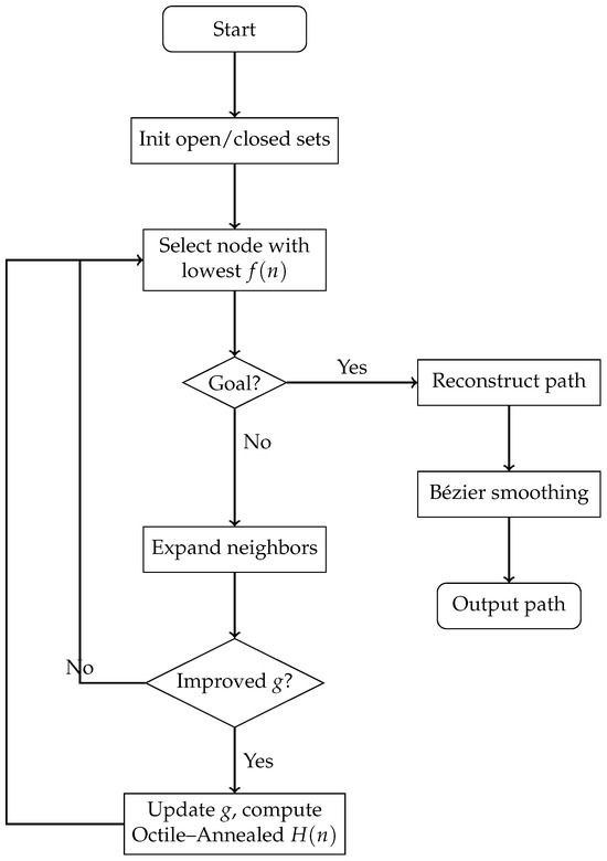
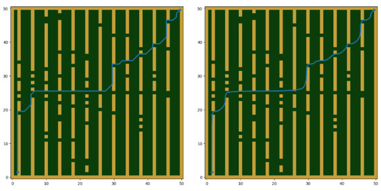
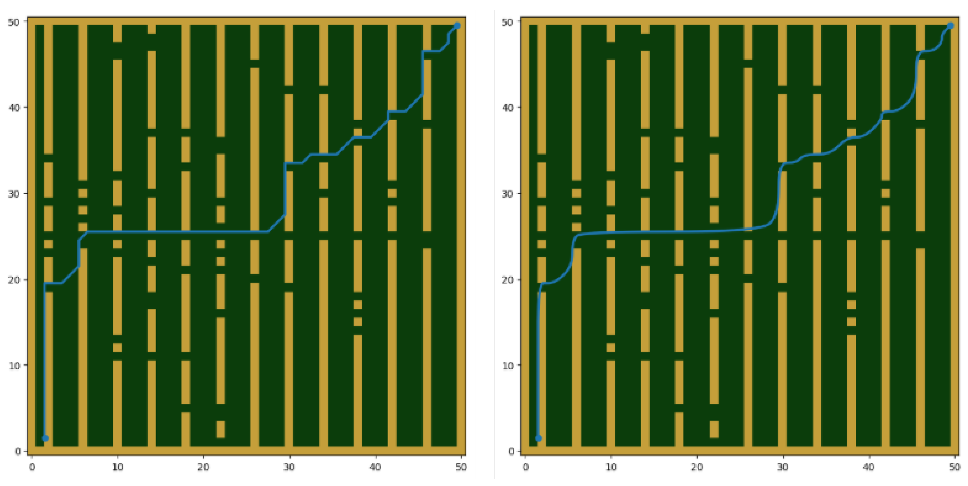
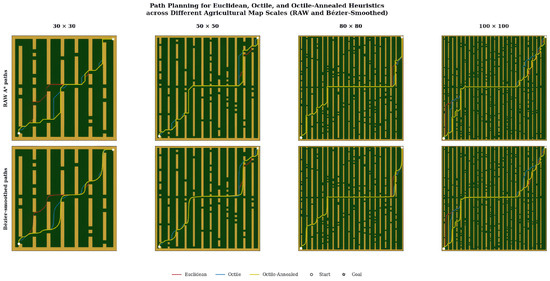
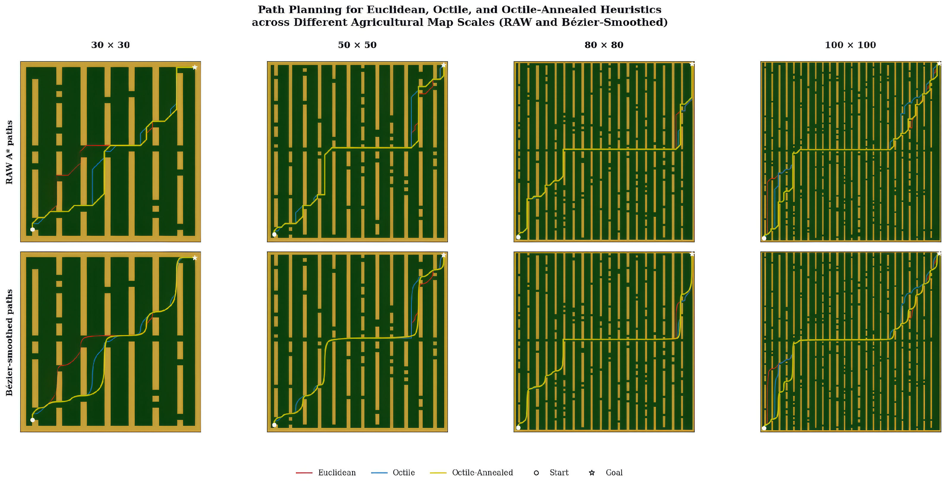
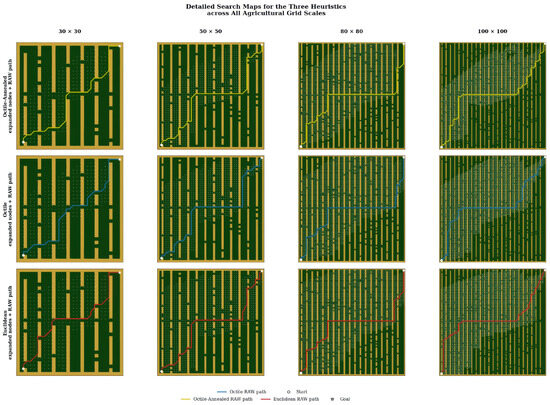
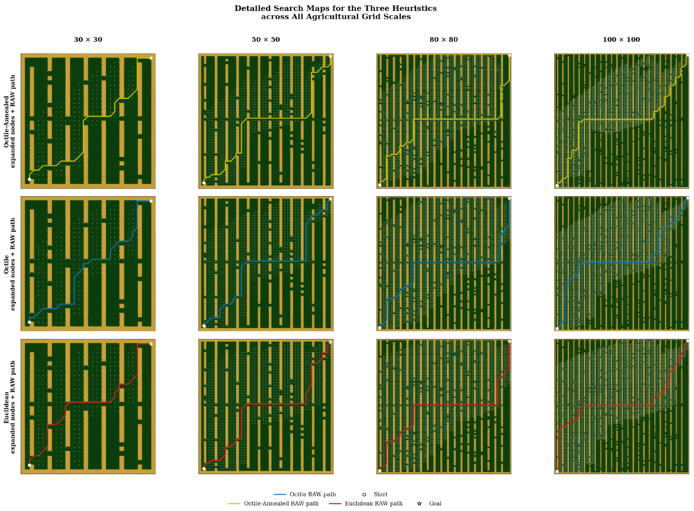
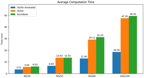
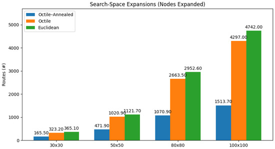
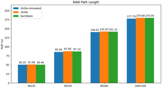
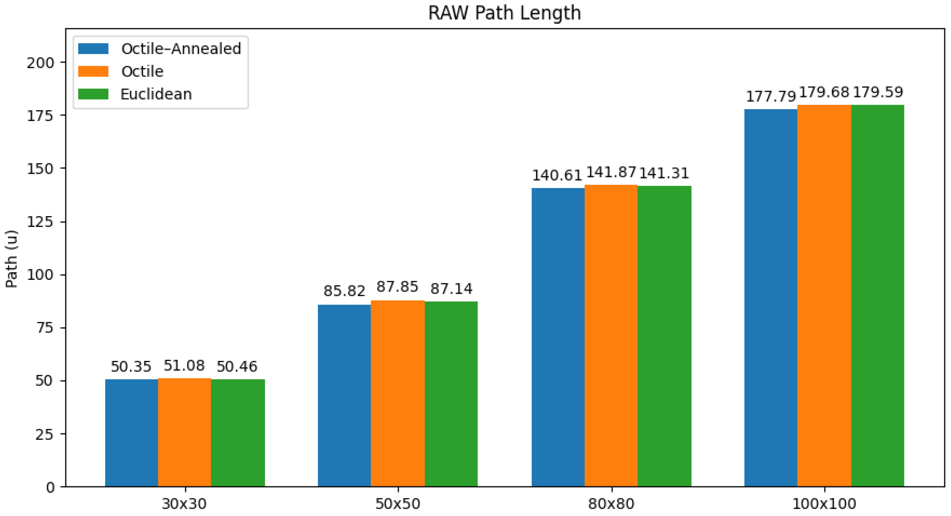
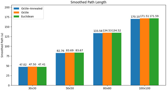
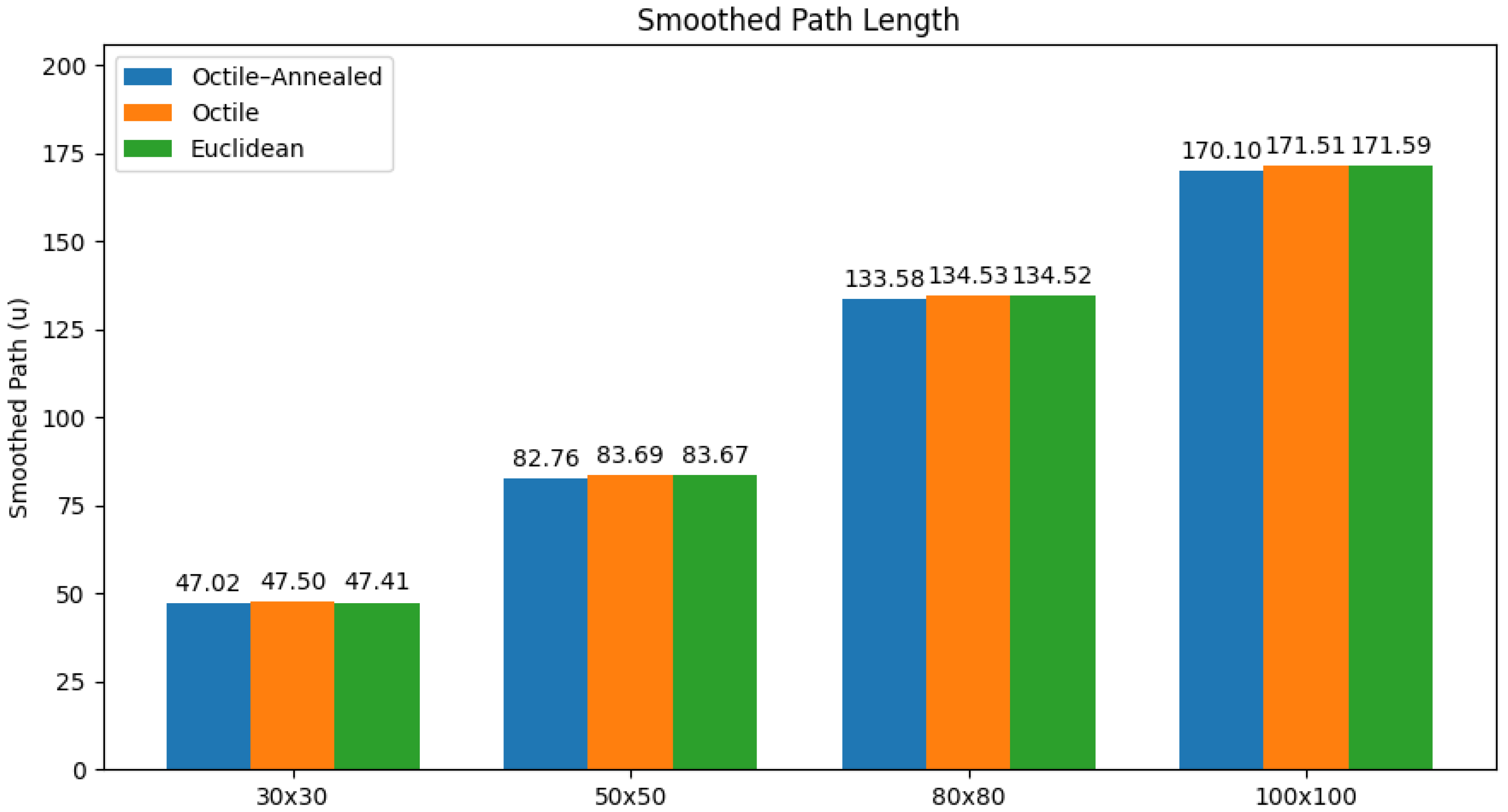
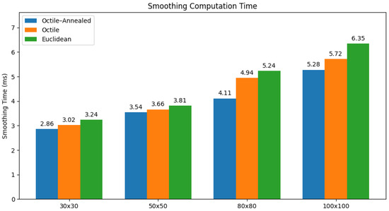
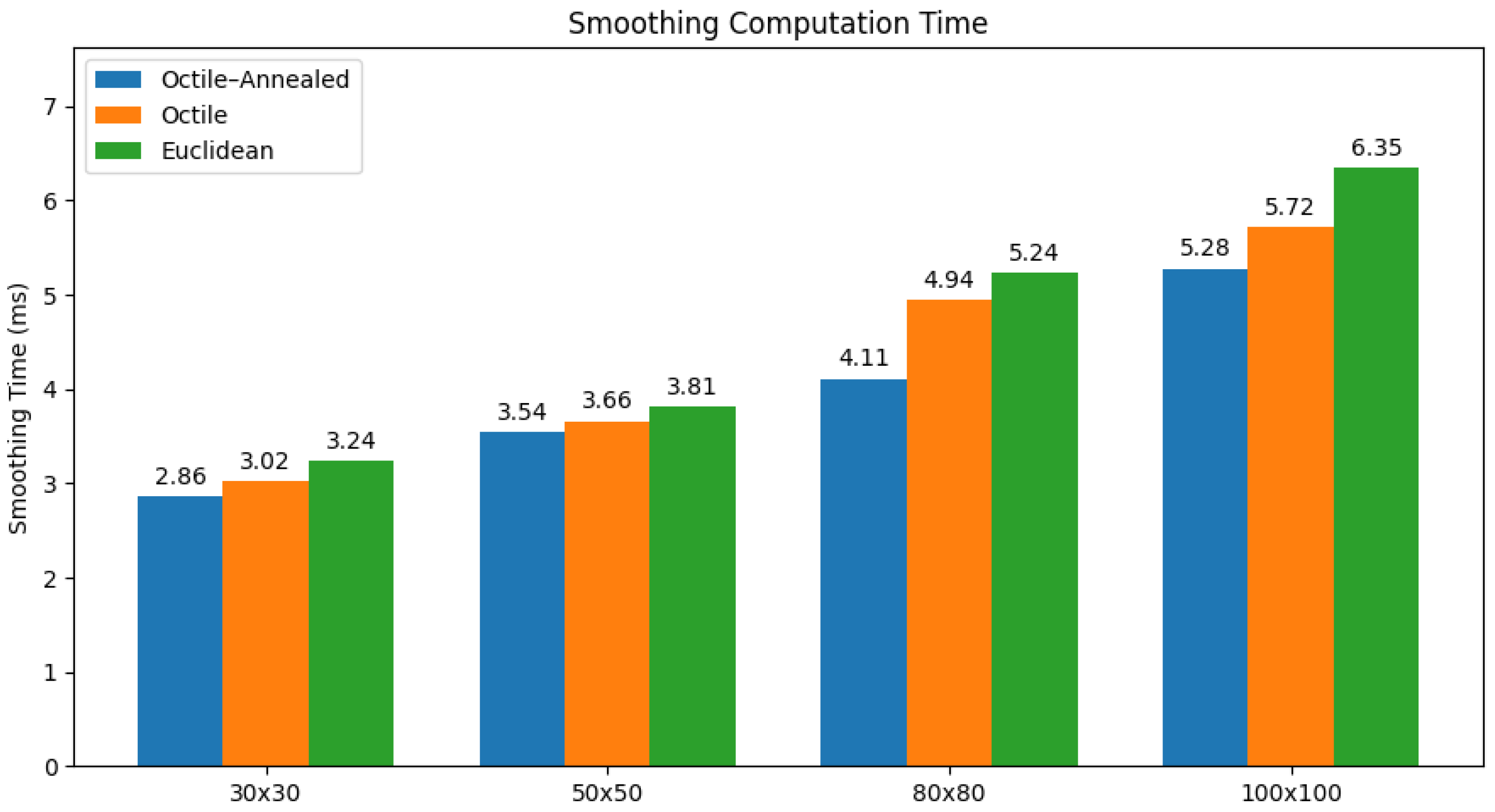
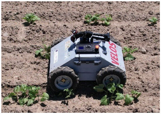
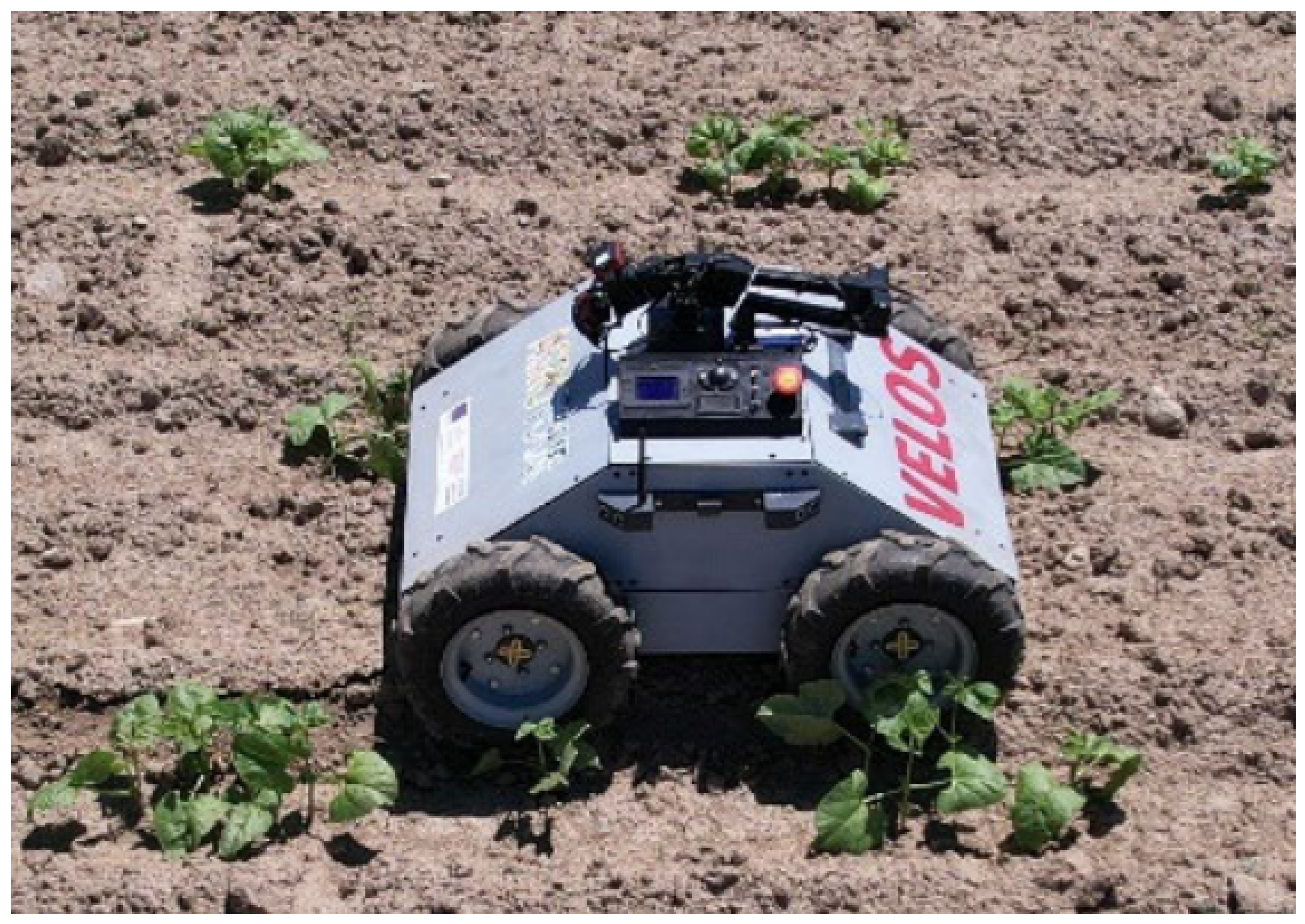

Disclaimer/Publisher’s Note: The statements, opinions and data contained in all publications are solely those of the individual author(s) and contributor(s) and not of MDPI and/or the editor(s). MDPI and/or the editor(s) disclaim responsibility for any injury to people or property resulting from any ideas, methods, instructions or products referred to in the content. |
© 2026 by the authors. Licensee MDPI, Basel, Switzerland. This article is an open access article distributed under the terms and conditions of the Creative Commons Attribution (CC BY) license.