1. Introduction
Jordan hosts an exceptional concentration of cultural heritage sites spanning multiple historical periods, ranging from the Nabataean city of Petra and the Roman remains of Jerash to early Islamic desert palaces. These sites possess outstanding national and international significance and attract scholars and visitors from around the world. Despite their historical value, Jordan’s heritage assets face increasing threats that challenge their long-term preservation. Environmental degradation, human activities, and limited conservation resources continue to compromise the integrity of these cultural treasures [
1,
2]. Many heritage sites are located within harsh arid environments where extreme temperature variations, sandstorms, and wind erosion accelerate material decay and structural deterioration [
3]. In parallel, human-induced pressures pose substantial risks. While tourism plays a vital role in the national economy, uncontrolled visitor access, vandalism, and inappropriate restoration practices significantly contribute to physical degradation. Furthermore, urban expansion and infrastructure development in proximity to protected heritage zones often result in irreversible impacts. The lack of sufficient financial resources further constrains conservation efforts [
4]. In response to these challenges, digital documentation technologies have emerged as essential tools for heritage management. Among these, Heritage Building Information Modelling (HBIM) has gained considerable attention for its capacity to integrate geometric, material, and historical information within a unified digital environment. By combining terrestrial laser scanning (TLS), photogrammetry, and parametric modelling, HBIM enables the creation of information-rich three-dimensional representations that support documentation and conservation planning [
5,
6]. Recent years have witnessed growing interest in the application of BIM for heritage documentation and conservation. HBIM, in particular, has proven to be a transformative tool that enhances documentation accuracy, supports restoration planning, and enables long-term heritage management [
7]. Early HBIM research introduced parametric modelling for historical buildings, combining laser scanning and photogrammetry to develop reusable object libraries for architectural elements such as columns and vaults. Subsequently, ref. [
5] demonstrated the applicability of HBIM for medieval castles in Ireland, emphasizing the importance of standardized methodological approaches.
In the Middle Eastern context, the Jeddah Historical Building Information Modelling (JHBIM) project significantly contributed to the field. The project documented heritage buildings in Historic Jeddah, particularly the Nasif Historical House, by integrating laser scanning data with archival architectural records [
8]. The resulting HBIM model preserved both architectural and structural characteristics, supporting conservation in complex urban environments. Furthermore, integrating HBIM with Geographic Information Systems (GIS) provided a holistic approach for managing heritage assets within broader urban and environmental contexts [
9]. These studies collectively demonstrate the expanding role of HBIM in heritage conservation practice. However, despite these advances, several limitations remain evident. Existing HBIM workflows are often fragmented, lacking clear and reproducible integration pipelines that systematically combine multi-source reality-capture data with parametric modelling. In many cases, HBIM studies remain primarily focused on geometric reconstruction, while less attention is given to methodological transparency, documentation reliability, and the organization of heritage information within reusable digital environments. This limitation is particularly relevant for arid desert heritage sites, where irregular masonry, environmental exposure, and limited archival records require clear and reproducible documentation workflows. Accordingly, there remains a need for case-based studies that demonstrate how existing reality-capture and HBIM methods can be adapted to document desert heritage architecture in a structured and transferable manner.
To address these limitations, this study presents a structured Scan-to-HBIM workflow for the digital documentation of Umayyad desert architecture, using Qasr Harrana in Jordan as a representative case study. The proposed workflow integrates terrestrial laser scanning (TLS), close-range photogrammetry, and Heritage Building Information Modelling (HBIM) within a transparent and reproducible documentation framework. The objective is not to introduce a new surveying technology or modelling algorithm, but rather to demonstrate how established reality-capture and HBIM methods can be systematically combined to support the documentation of architecturally complex heritage assets in arid environments.
Qasr Harrana was selected because it represents one of the most significant and well-preserved examples of Umayyad desert architecture. Like many heritage monuments located in semi-arid regions, the site is exposed to environmental deterioration, irregular masonry conditions, and limited historical documentation, which present challenges for conventional documentation approaches. The resulting HBIM model organizes geometric, architectural, historical, and condition-related information within a unified digital environment, providing a reusable documentation resource that can support future conservation, management, and research activities.
By focusing on the practical implementation of a Scan-to-HBIM workflow in a desert heritage context, the study contributes to improving the transparency, reproducibility, and information management capabilities of existing heritage documentation practices [
10,
11]. The remainder of this paper is organized as follows.
Section 2 reviews previous studies related to HBIM, TLS, and heritage documentation.
Section 3 presents the proposed Scan-to-HBIM methodology.
Section 4 discusses the results and HBIM implementation. Finally,
Section 5 presents the implications, limitations, and conclusions of the study.
1.1. Umayyad Palaces in Jordan
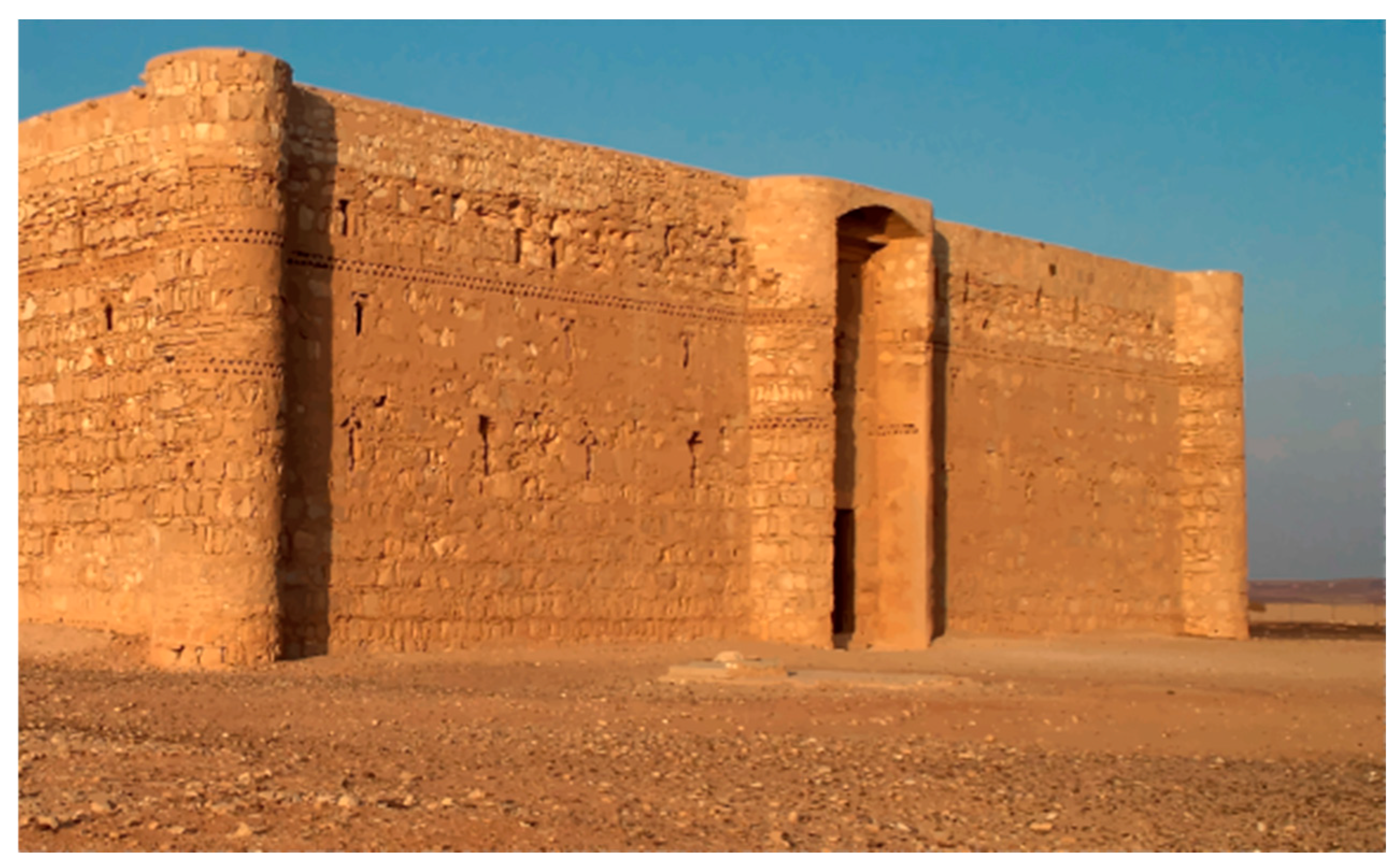
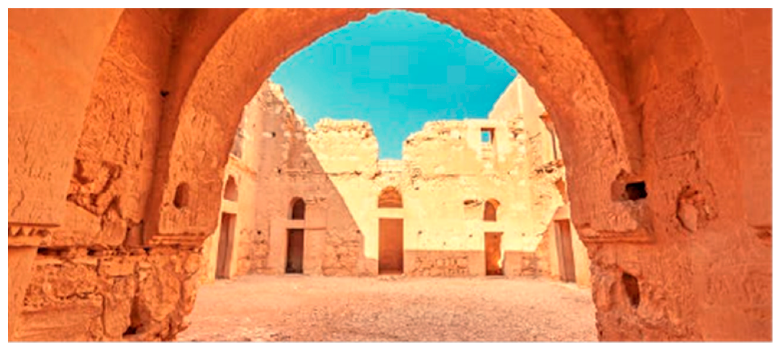
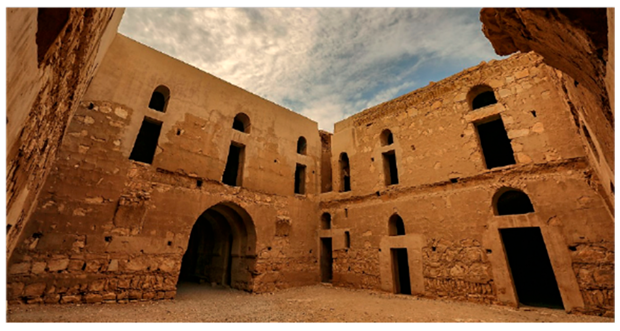
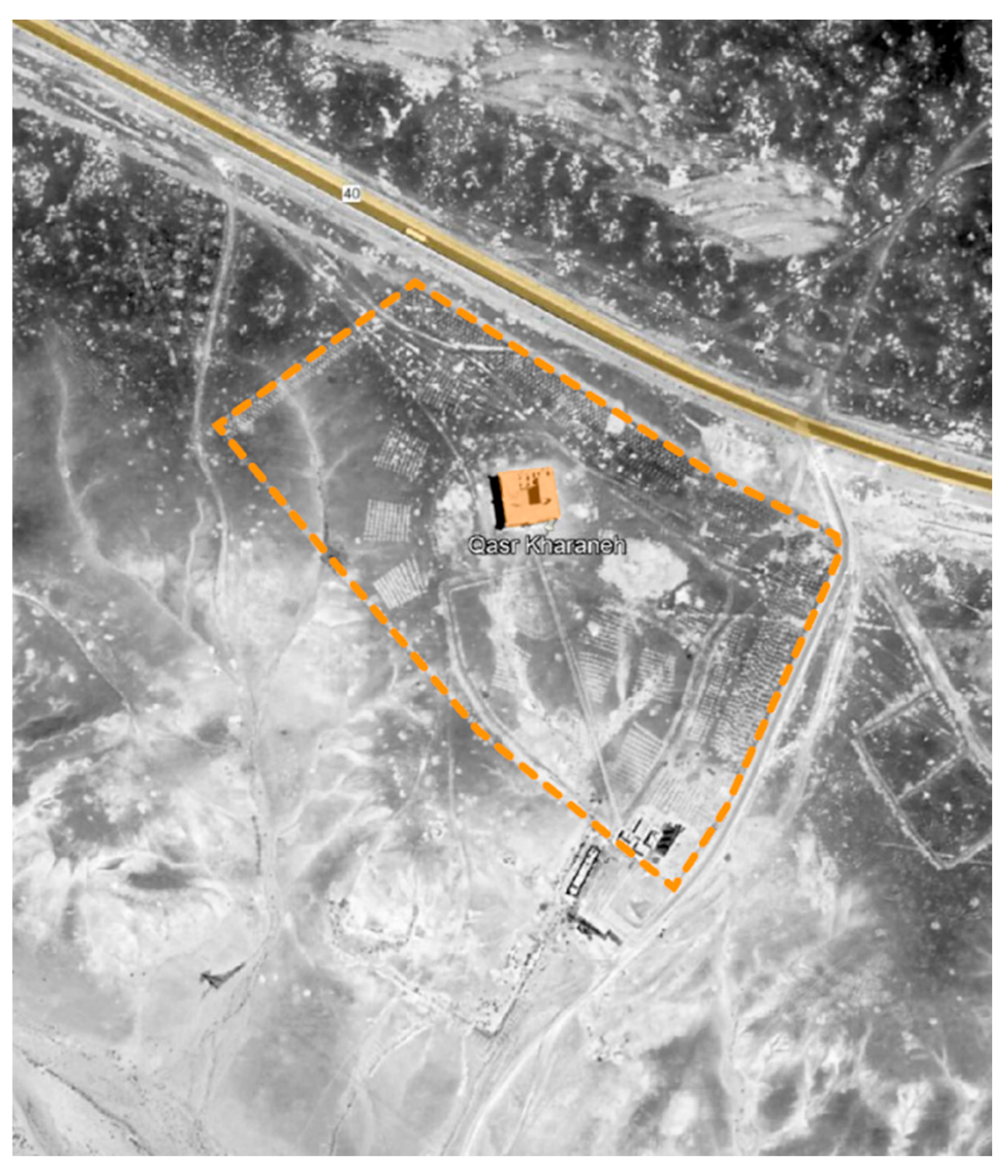
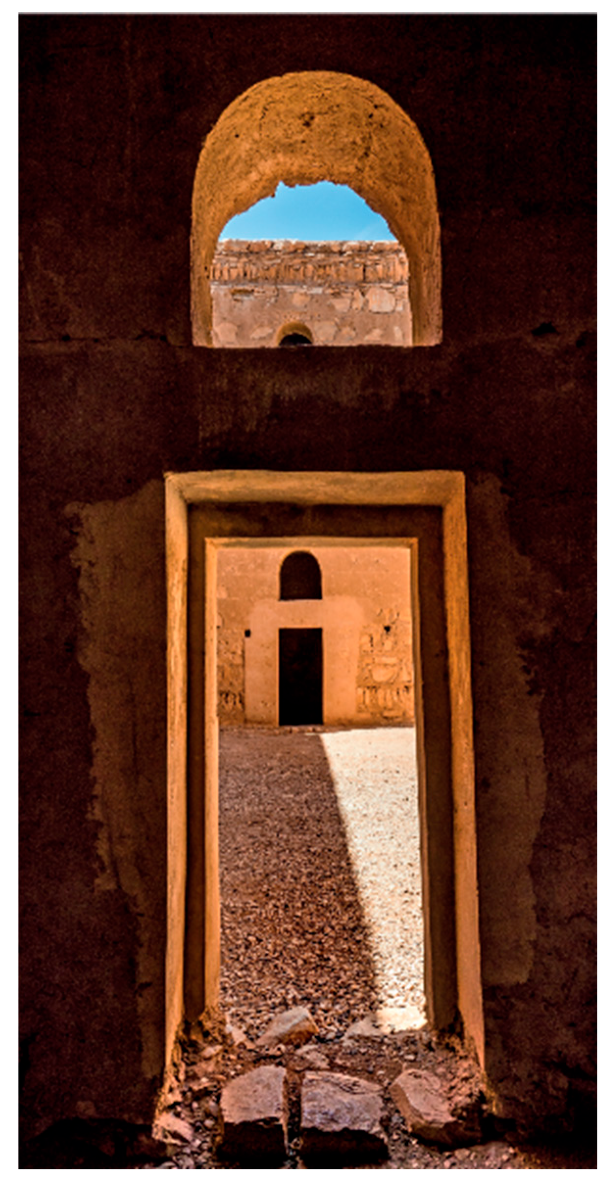
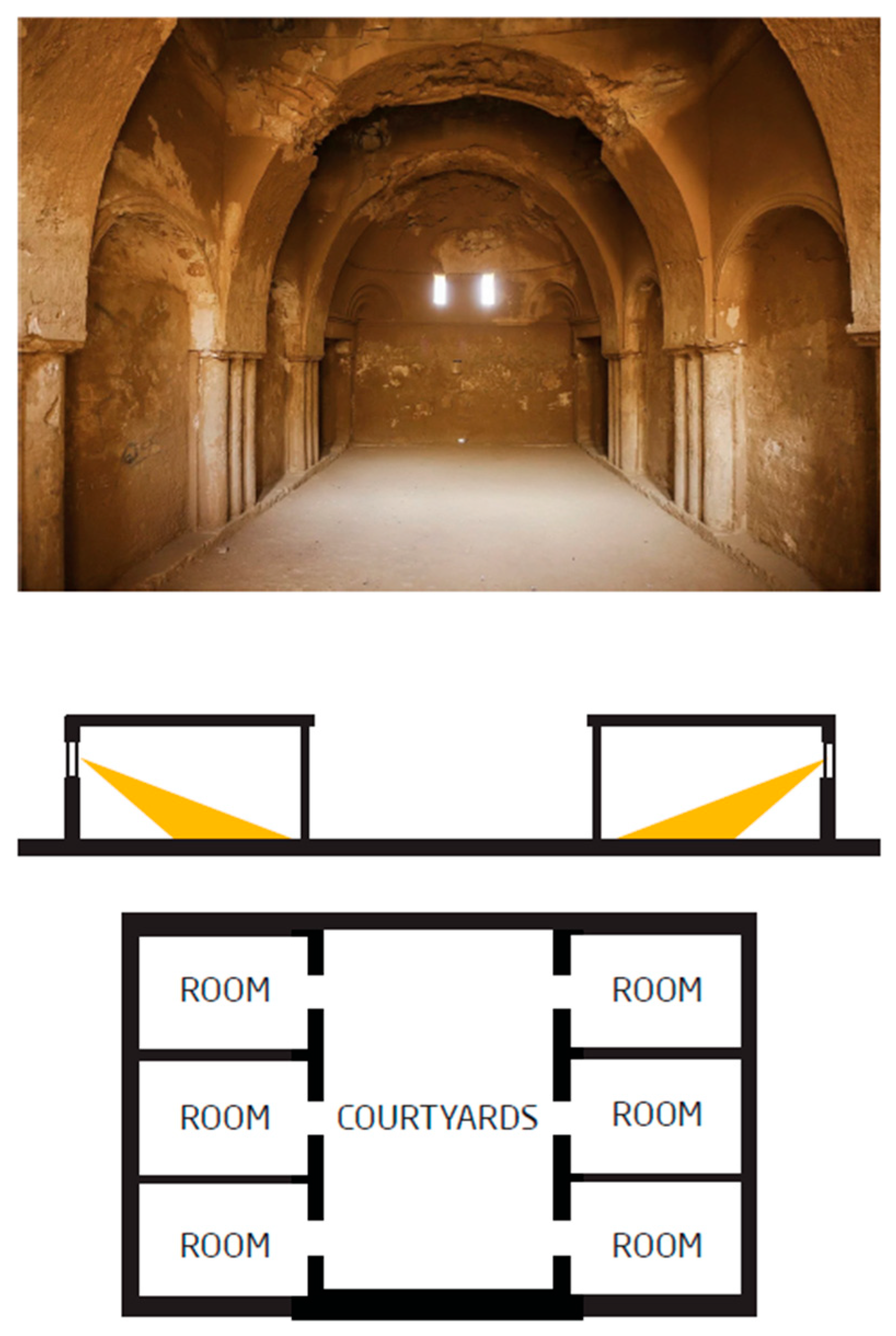
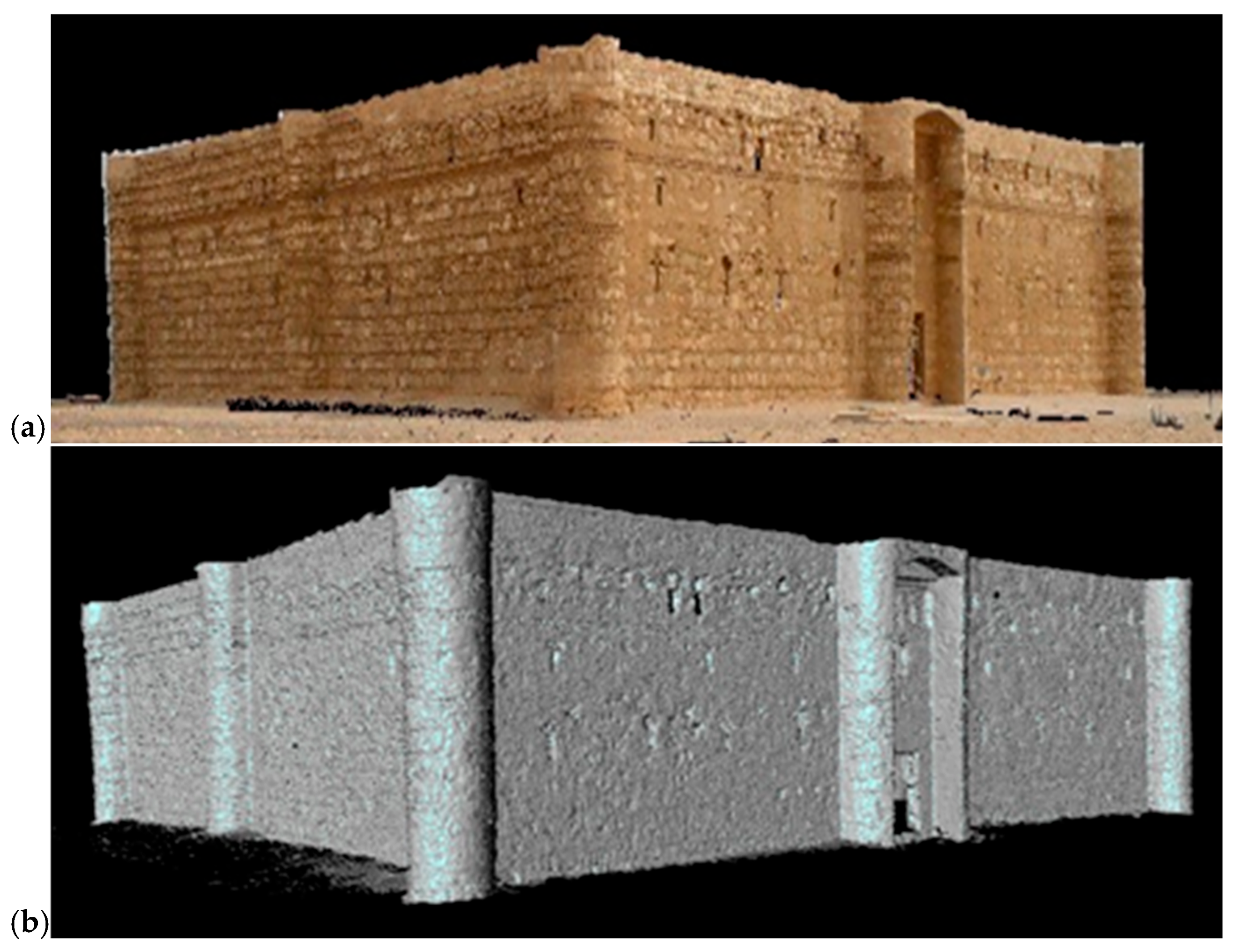
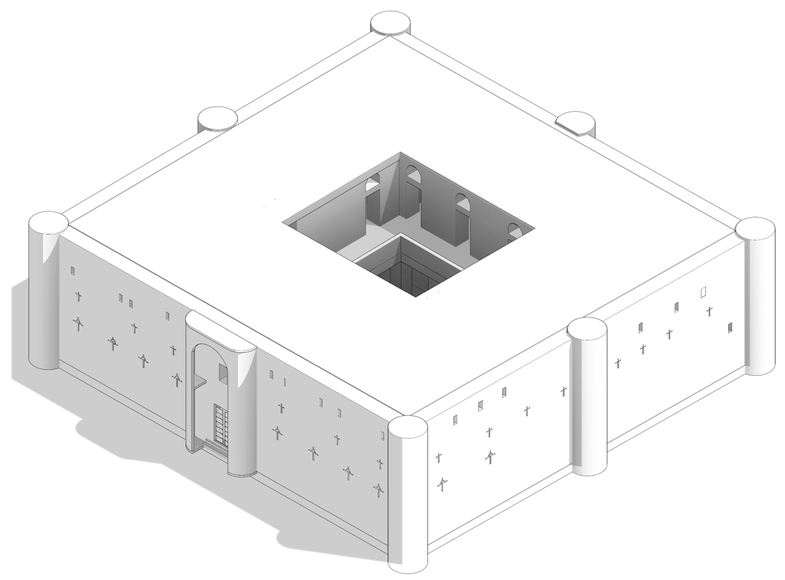
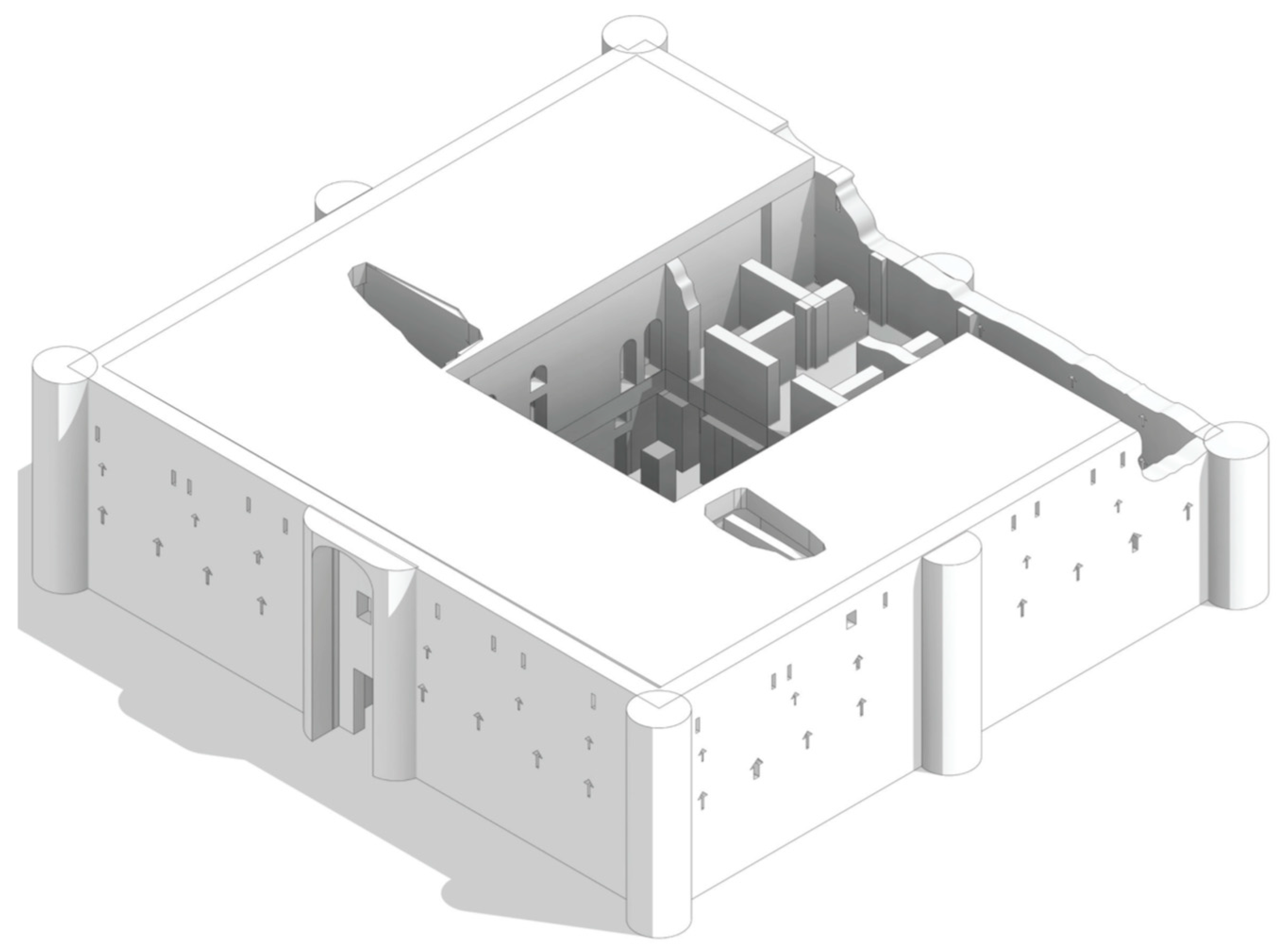
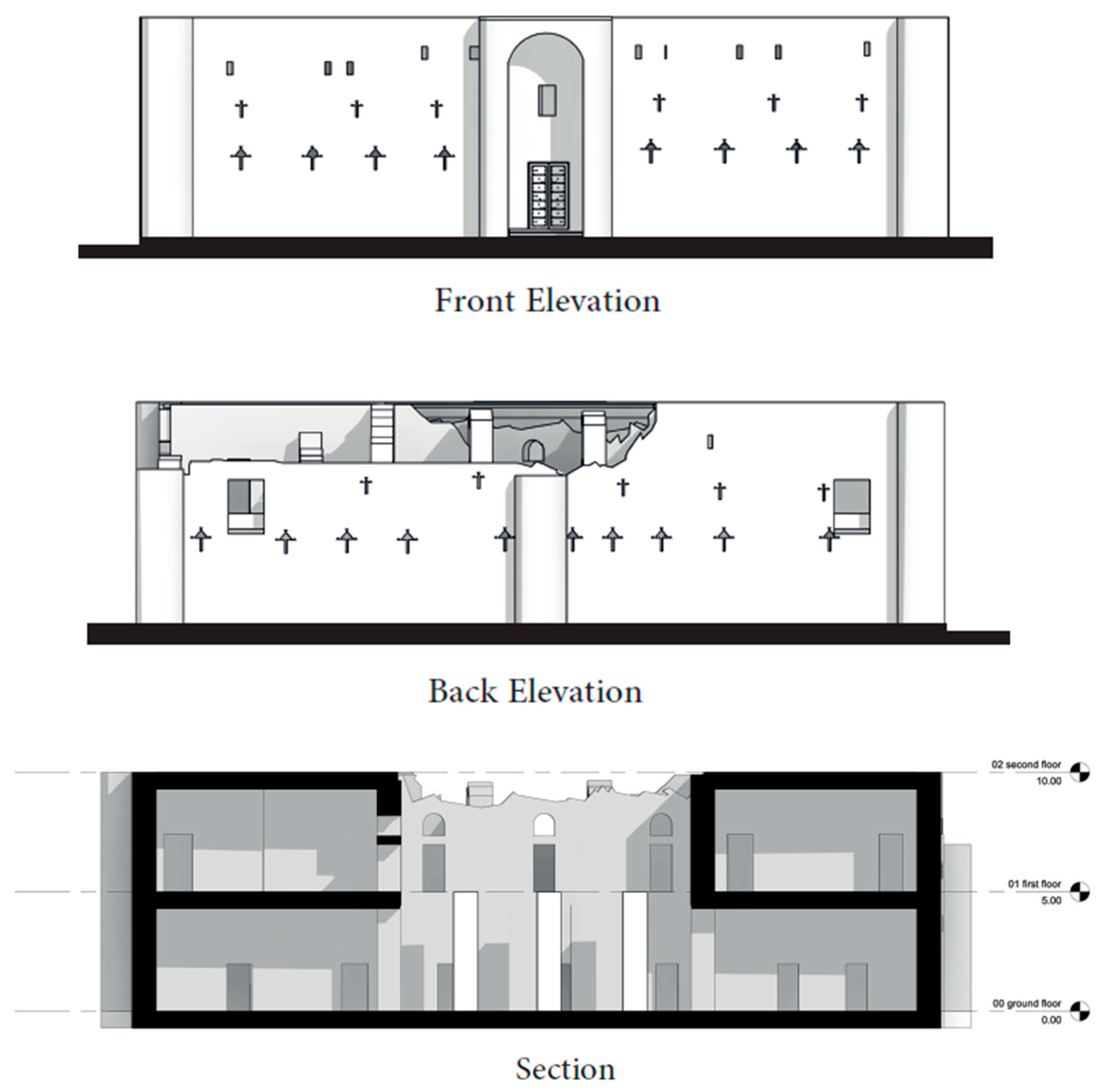
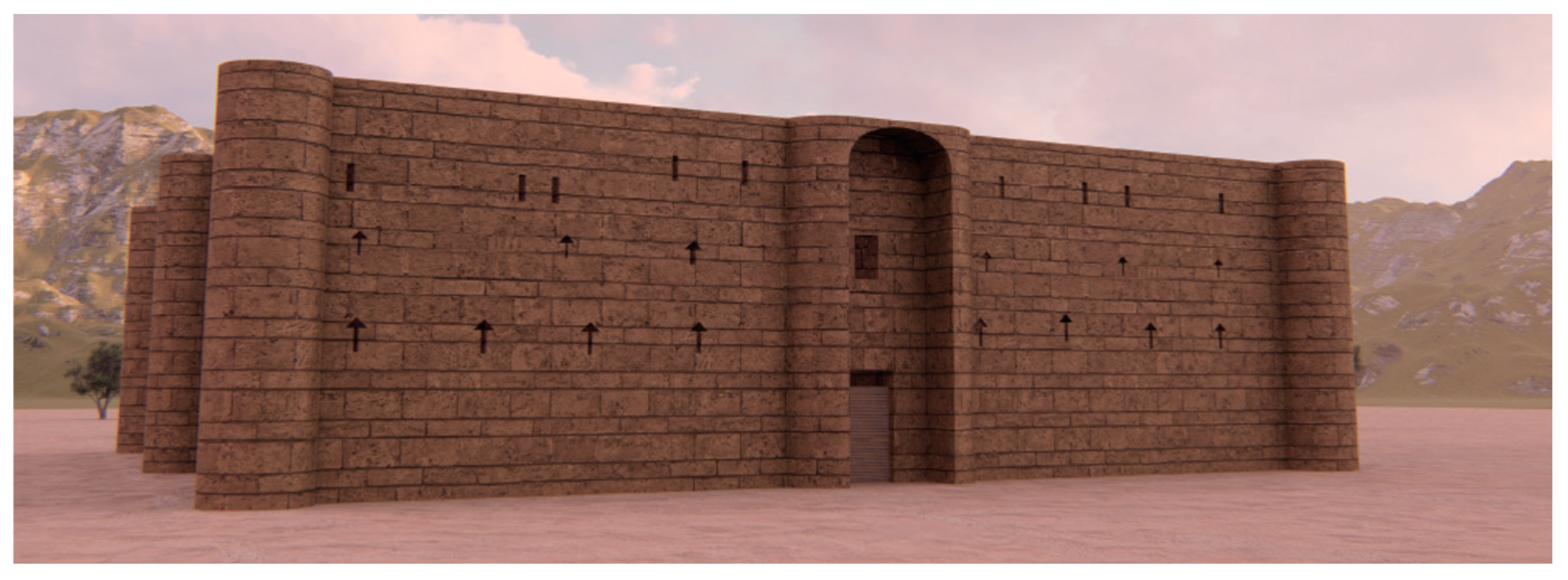
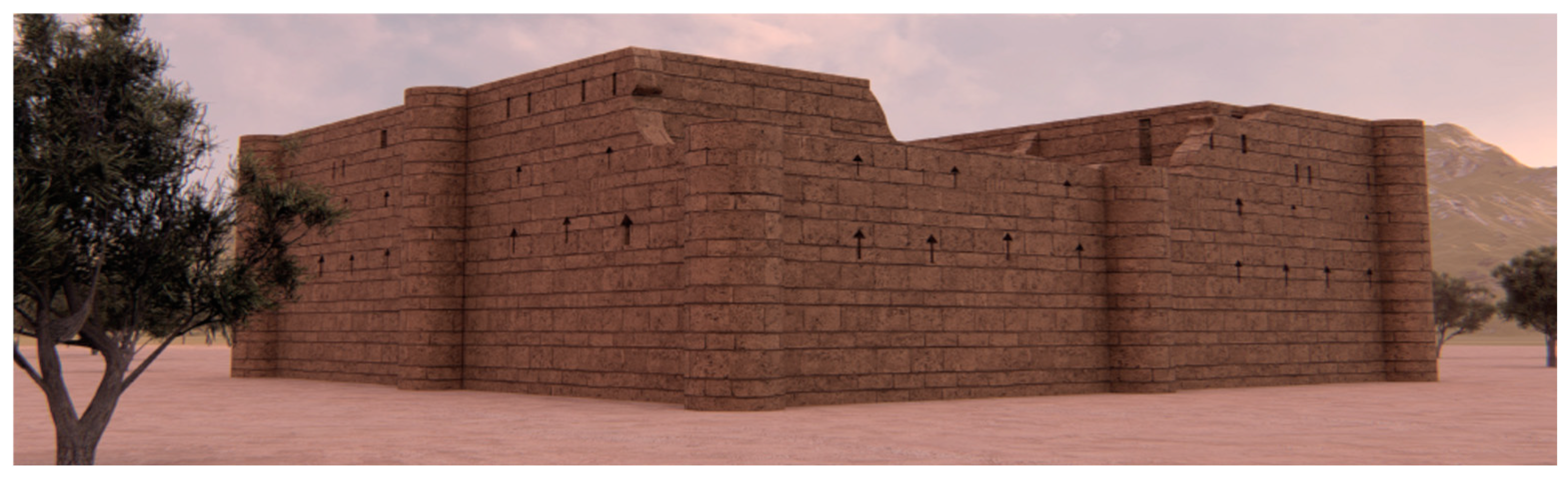
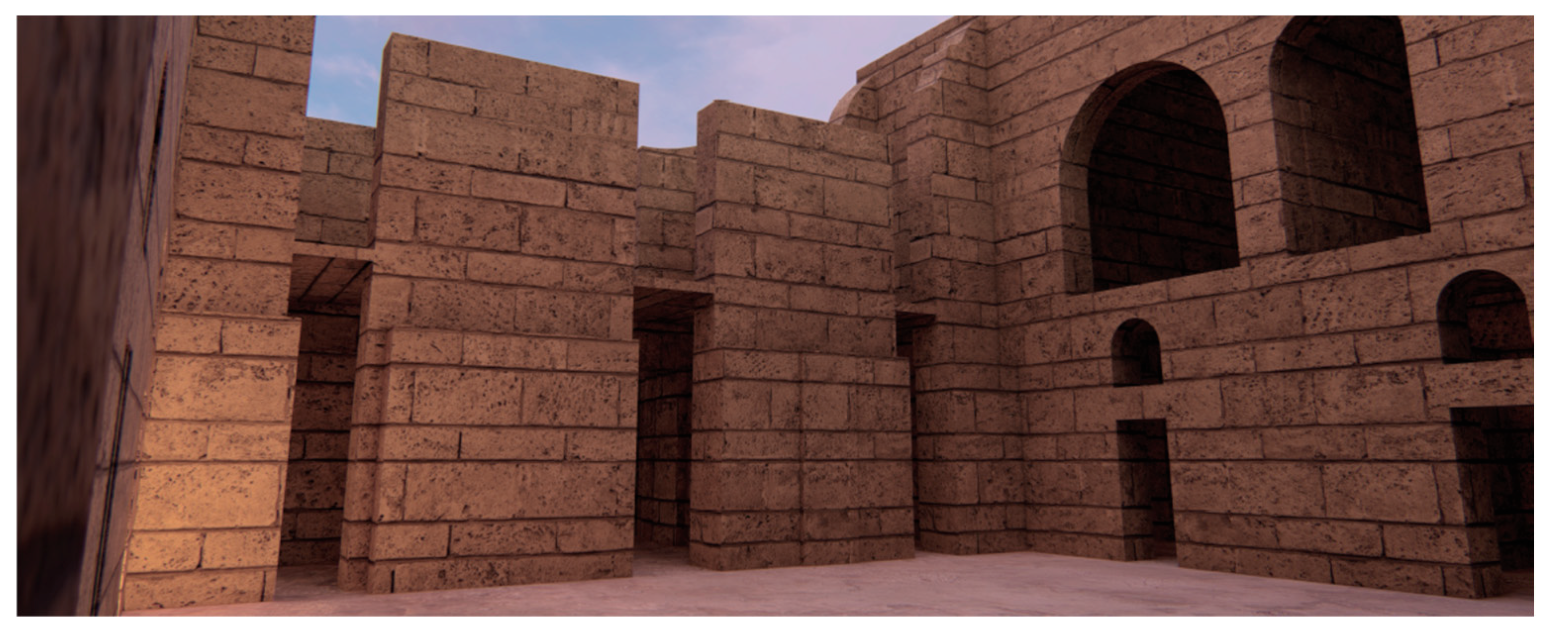
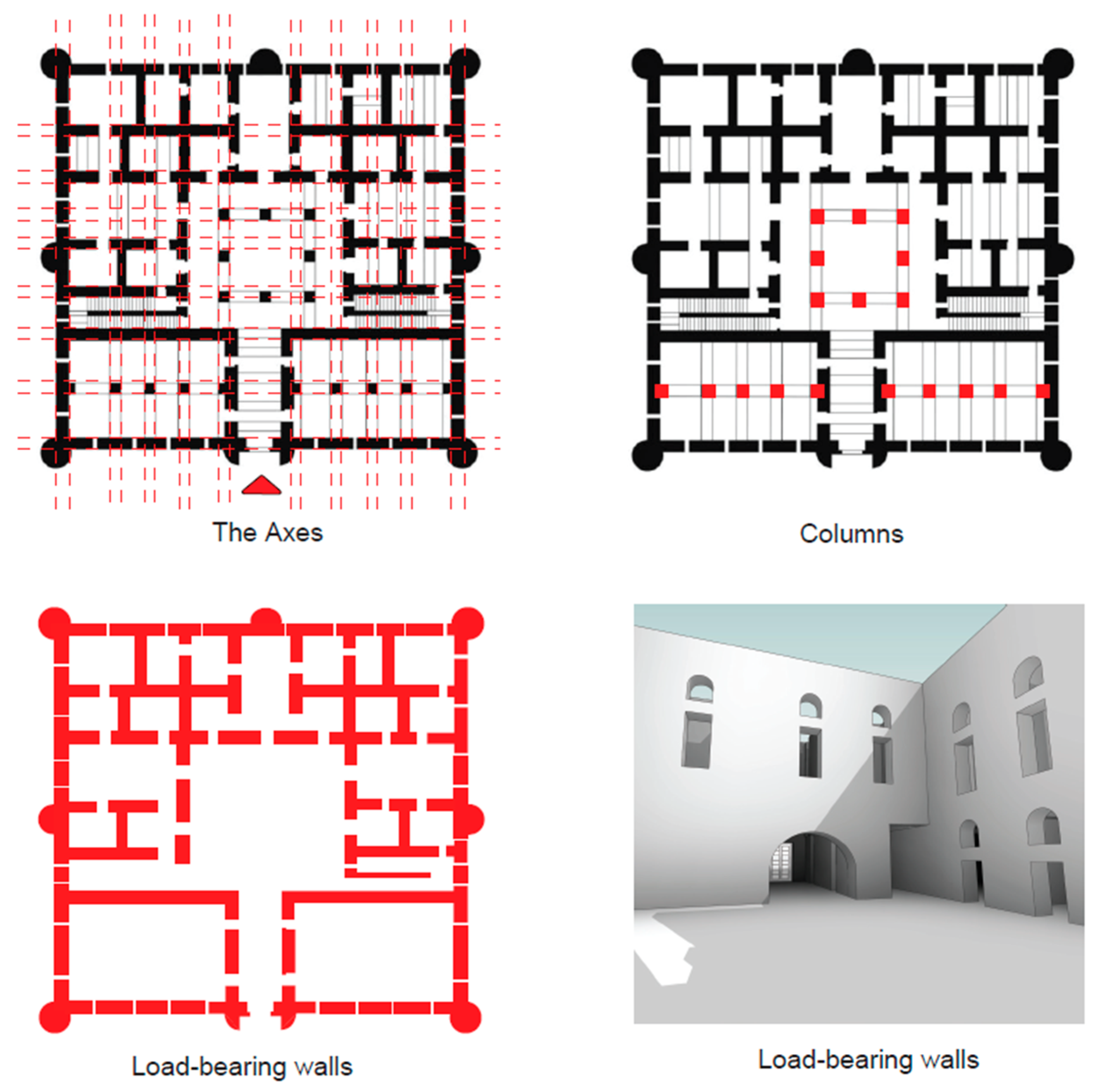
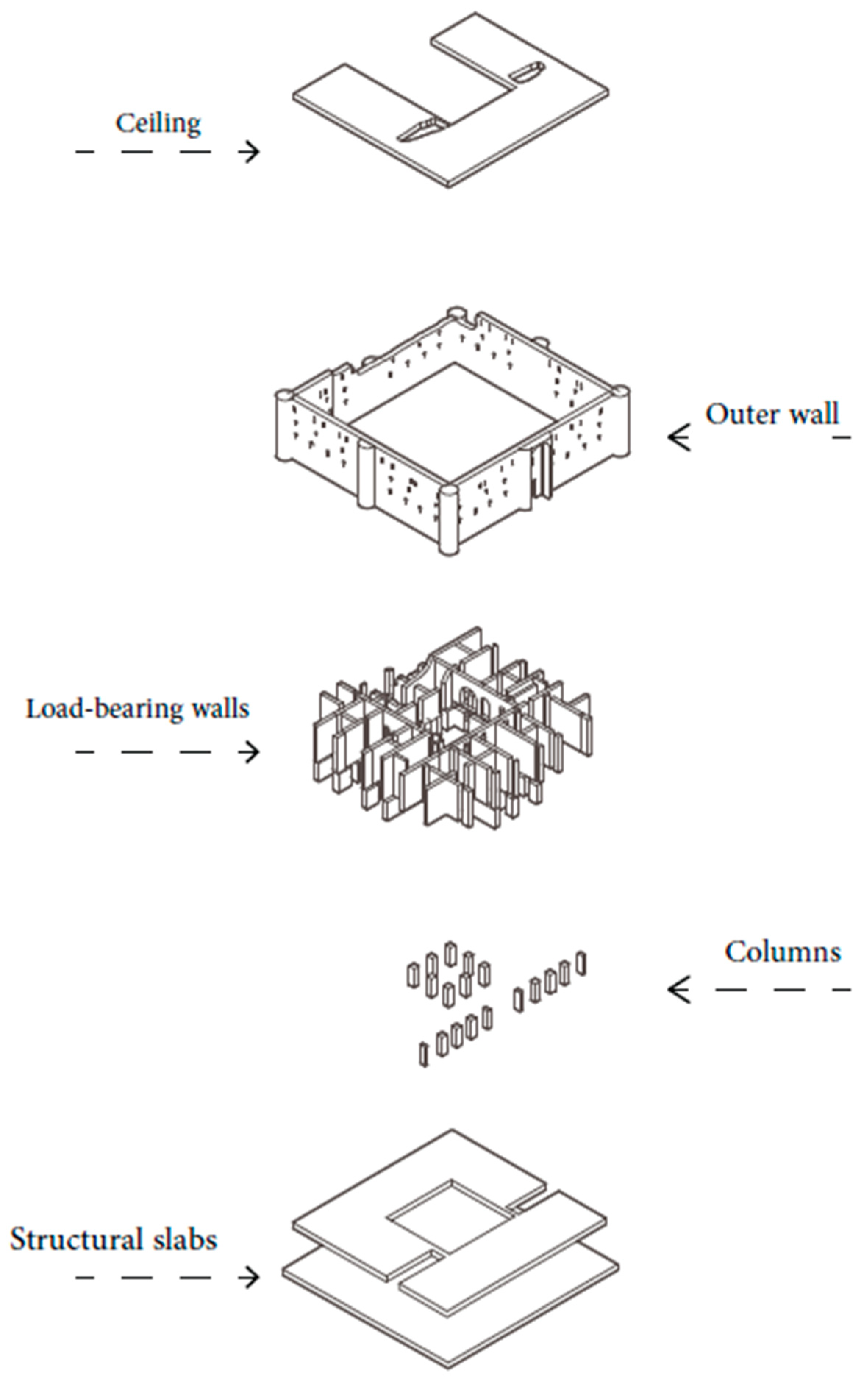
Qasr Harrana, shown in (
Figure 1,
Figure 2 and
Figure 3), is among the most significant desert castles in Jordan and occupies a prominent position in the country’s archaeological and cultural landscape [
12]. Located approximately 60 km east of Amman, this early eighth-century structure forms part of a wider network of Umayyad desert palaces reflecting the political, social, and architectural developments of the early Islamic period [
13]. The palace is characterized by a square plan measuring approximately 35 m per side and constructed from local limestone. It consists of two stories organized around a central courtyard. The architectural language reflects a synthesis of Roman, Byzantine, and Sassanian influences integrated with early Islamic design principles [
12]. While the exact function of Qasr Harrana remains debated, its defensive walls, arrow slits, and elevated position suggest potential military or protective functions, although alternative interpretations propose its use as a royal retreat or caravanserai [
14]. The main architectural components include an audience hall, bathing complex, and hydraulic system, characterized by vaulted ceilings supported by transverse arches [
15,
16]. These monuments illustrate the adaptation of pre-Islamic architectural traditions within the emerging Islamic empire and symbolize the transition from nomadic to settled lifestyles. As historical structures, they provide invaluable insight into Umayyad architectural innovation and sociopolitical dynamics [
12]. However, harsh desert conditions, temperature fluctuations, wind erosion, and human activities continue to accelerate material deterioration [
17], necessitating advanced documentation and management strategies.
1.2. Importance of Accurate Architectural Documentation for Heritage Conservation
Accurate architectural documentation is fundamental to the preservation and sustainable management of cultural heritage sites. For historic structures such as Qasr Harrana, precise records are essential not only for safeguarding physical integrity but also for understanding architectural, cultural, and historical significance [
18]. Documentation provides a detailed baseline of existing conditions, guiding conservation interventions and ensuring decisions are supported by reliable information. Furthermore, documentation supports scholarly research by preserving knowledge of original construction techniques, materials, and spatial configurations [
19,
20,
21]. In Jordan, where heritage sites are continuously exposed to harsh environmental conditions and tourism pressures, traditional documentation methods such as manual surveys and 2D drawings often fail to capture geometric complexity and fine architectural details [
12,
17,
22]. To overcome these limitations, Jordan has increasingly adopted HBIM-based approaches. The parametric heritage modelling enables the integration of geometric, structural, and historical information into comprehensive three-dimensional models [
23,
24,
25]. For sites such as Qasr Harrana, HBIM facilitates visualization and supports long-term conservation strategies [
26,
27,
28].
1.3. Heritage Sites Issues
Jordanian heritage sites face significant environmental and anthropogenic challenges. In desert regions, temperature extremes, wind erosion, sandstorms, and flash floods accelerate material decay, while urban expansion and tourism-related activities further exacerbate deterioration [
1,
3]. These conditions highlight the need for systematic and reliable digital documentation capable of recording the current state of heritage assets before further loss of historical fabric occurs. In this context, HBIM provides an effective response by enabling high-precision documentation and the structured organization of architectural, historical, and technical information within a unified digital environment [
5,
6]. For example, laser scanning supports the accurate recording of walls, arches, openings, and surface irregularities, providing a geometric basis for visual inspection and future comparison [
29]. Moreover, HBIM centralizes fragmented historical and technical records into a unified digital environment, enhancing interdisciplinary collaboration [
23]. Additionally, parametric heritage modelling supports sustainable tourism through virtual heritage experiences, reducing physical visitor impact while enhancing public engagement [
30,
31]. By integrating documentation and digital dissemination strategies, HBIM strengthens Jordan’s commitment to heritage protection [
32].
1.4. The Aim
The main aim of this research is to develop and demonstrate a structured Scan-to-HBIM workflow for the digital documentation of Umayyad desert architecture, using Qasr Harrana as a representative case study. The study focuses on the integration of TLS, supporting photographic documentation, and parametric HBIM to generate a reusable digital record of the monument. The proposed workflow organizes geometric, architectural, historical, and condition-related information within a single HBIM environment. The objective is not to propose a new surveying technology or conservation intervention, but to demonstrate how established reality-capture and HBIM methods can be adapted to support systematic documentation and future heritage management in arid architectural contexts.
1.5. The Contribution
This study contributes to the advancement of Scan-to-HBIM applications by introducing a structured, context-specific workflow tailored to the documentation and analysis of desert heritage environments. The novelty of this study should therefore be understood as contextual and operational rather than technological. The research does not propose a new scanning or photogrammetric algorithm; instead, it demonstrates how established TLS, photogrammetry, and HBIM methods can be organized and adapted to support heritage documentation and information management.
Unlike conventional approaches that primarily focus on geometric reconstruction, the proposed framework integrates data acquisition, processing, modelling, and validation within a unified and reproducible methodological pipeline explicitly aligned with heritage documentation objectives. First, the research develops a reproducible TLS–photogrammetry integration workflow specifically adapted to the constraints of arid heritage contexts. The workflow documents and organizes data acquisition strategies, point cloud processing procedures, registration protocols, and multi-source data integration within a transparent and sequential pipeline. This structured approach contributes to improving the clarity and reproducibility of existing HBIM integration practices within desert heritage documentation workflows. Second, the study generates a semantically enriched HBIM model of Qasr Harrana with explicitly defined Levels of Detail (LOD) and Levels of Information (LOI).
Beyond geometric representation, the model embeds material, historical, and condition-related attributes, enabling a multi-layered understanding of the monument. This positions the HBIM model not merely as a documentation output, but as an analytical and information-rich digital environment. Third, the research establishes a parametric HBIM object library representing characteristic architectural elements of Umayyad desert palaces, including walls, arches, openings, vaults, and towers. These components are defined through parametric rules and typological constraints, allowing their reuse and adaptation across similar desert heritage structures. This contributes to the development of scalable HBIM practices for under-documented architectural typologies. Fourth, the study includes a practical geometric verification step to assess the consistency between selected HBIM-derived measurements and the original survey-based references. This step was used as a quality-control procedure to identify major discrepancies introduced during manual and semi-manual modelling. The reported 2–5 cm deviations should therefore be interpreted as practical documentation tolerances rather than as a complete metrological uncertainty assessment.
The observed geometric deviations generally ranged between 2 and 5 cm, which was considered acceptable for the intended HBIM-based documentation applications of the study. These values are reported as practical documentation indicators rather than as a full metrological assessment. Future work may extend this validation through RMSE-based evaluation, standard deviation reporting, and deviation mapping across repeated survey campaigns.
Finally, the study demonstrates how HBIM can be structured to organize geometric, architectural, historical, and condition-related information within a unified digital environment. The resulting model allows condition observations to be associated with individual architectural components, facilitating systematic documentation and future updating of heritage information. Rather than implementing a monitoring system or preventive conservation framework, the study provides a digital documentation foundation that may support future conservation, maintenance, and management activities. Collectively, the proposed workflow offers a transferable Scan-to-HBIM approach for the documentation of desert heritage architecture and contributes to improving the organization and accessibility of heritage information within HBIM environments.
While Scan-to-HBIM workflows have been widely reported for European heritage sites, documented applications focusing on Umayyad desert architecture remain limited. The contribution of this study therefore lies in adapting and demonstrating a transferable documentation workflow for a heritage typology that remains underrepresented in the HBIM literature.
3. The Methodology
3.1. Scan-to-Heritage BIM Approach
This study adopts a Scan-to-HBIM approach to document and digitally model Qasr Harrana, integrating reality-capture data with BIM-based parametric modelling to produce an information-rich heritage model. The workflow is implemented as an interdisciplinary, student-based approach, where the reality-capture stage is performed within geomatics training activities, and the modelling stage is conducted within an undergraduate architecture graduation context. The methodology follows four sequential phases: (i) data acquisition, (ii) point cloud processing and data preparation, (iii) HBIM and semantic enrichment, and (iv) integration of historical and construction documentation.
Reality capture is conducted using terrestrial laser scanning (TLS) to obtain high-density geometric information, while close-range photogrammetry is used to provide high-resolution imagery suitable for texture and surface condition interpretation. TLS offers millimetre-level geometric reliability and comprehensive spatial coverage, whereas photogrammetry complements this geometry by capturing colour, texture, and surface detail [
6]. The combined datasets form the geometric and visual foundation for heritage digital documentation generation within a BIM environment, following established HBIM principles and parametric modelling logic [
36]. The resulting HBIM model is developed to support heritage documentation and analysis, while remaining structured for reuse and future updating.
3.2. Sensors Applied and Data Acquisition
In our research, we obtained the surface point cloud for our investigations using the Mensi GS100 Laser Scanner (MENSI S.A., Fontenay-sous-Bois, France), which can measure scanning distances ranging from 2 to 100 m. Five thousand points are acquired every second by the flight time scanner. A 768 × 576 pixel resolution camera built into the system is used to map colour to the appropriate locations. Point clouds have been produced at medium distances using terrestrial laser scanners. Since the scene’s characteristics limit the number of possible sensor locations, selecting viewpoints is a crucial step in the survey. To offer three-dimensional coverage, eight distinct scanner perspectives have been selected for each of the palaces. The results of point clouds and the meshed model of Al Harraneh are shown in
Figure 8 and
Figure 9. Additional images were also collected separately using a Nikon D2x camera (Nikon Corporation, Tokyo, Japan) (4288 × 2848) at an optimal time for texture mapping of the 3D models generated using a laser scanner. Although the data acquisition campaign was conducted using earlier-generation surveying equipment, the resulting datasets remain suitable for HBIM generation and methodological evaluation due to the relatively stable geometry and scale of the monument. The registration and alignment procedures were performed using standard point-cloud registration workflows to ensure geometric consistency between scans and photogrammetric datasets. The registration process was performed using iterative closest point (ICP)-based alignment procedures, followed by visual inspection of overlapping areas to verify geometric consistency between adjacent scans. The generated HBIM model was developed at an architectural documentation level suitable for information management applications. The TLS survey primarily documented the external envelope and courtyard-facing elevations of Qasr Harrana. Interior spaces were not fully captured by TLS. Therefore, the reconstruction of internal rooms and spatial divisions was developed using available historical architectural drawings, photographic documentation, and architectural interpretation, while the TLS point cloud was used as the principal geometric reference for the exterior envelope, overall dimensions, levels, and visible openings. The integration process therefore followed a geometry-led approach, in which the registered point cloud constrained the HBIM reconstruction, and the photographic records supported semantic and visual interpretation. It should be noted that heritage documentation projects frequently rely on datasets acquired at different times and using different technologies. In many archaeological and heritage contexts, repeated data acquisition campaigns may be constrained by site accessibility, conservation regulations, permit requirements, or restrictions imposed by heritage authorities. Consequently, the reuse and integration of previously acquired reality-capture datasets remains a common practice within digital heritage documentation.
In the present study, the available TLS and photographic datasets were considered sufficiently reliable for HBIM generation and methodological evaluation. The objective was not to assess sensor performance, but rather to investigate how existing reality-capture datasets can be integrated and transformed into a semantically enriched HBIM environment for heritage documentation and information management.
A limitation of this study relates to the use of an earlier-generation TLS dataset acquired using the Mensi GS100 scanner (MENSI S.A., Fontenay-sous-Bois, France). Although contemporary TLS systems provide higher acquisition speed, denser point clouds, and improved automation, the available dataset was considered adequate for the intended HBIM documentation objectives. Future research may investigate the influence of modern reality-capture technologies on modelling efficiency, geometric completeness, and documentation accuracy.
3.3. Workflow for Creating the HBIM Model of Qasr Harrana
The HBIM creation process for Qasr Harrana begins with a comprehensive data collection phase, utilizing laser scanning and photogrammetry to gather both geometric and visual information. Laser scanning generates a detailed 3D point cloud of the structure, capturing its intricate architectural features with millimetre precision. Because the HBIM reconstruction involved manual and semi-manual modelling procedures, interpretative decisions were unavoidable, particularly in areas with irregular masonry, missing parts, or incomplete geometric information. To reduce this bias, the modelling process was continuously constrained by the registered point-cloud data, historical references, and visual evidence derived from photogrammetry. Therefore, reconstructed elements should be understood as informed HBIM interpretations rather than purely automated geometric extractions. The textures presented in the HBIM visualizations were intended primarily for architectural interpretation and modelling clarity rather than photorealistic material reconstruction. The geometric validation and analytical assessment relied on the registered point-cloud datasets rather than rendered surface textures.
Photogrammetry supplemented the TLS dataset by providing high-resolution images that supported the interpretation of texture, colour, material characteristics, and visible surface conditions [
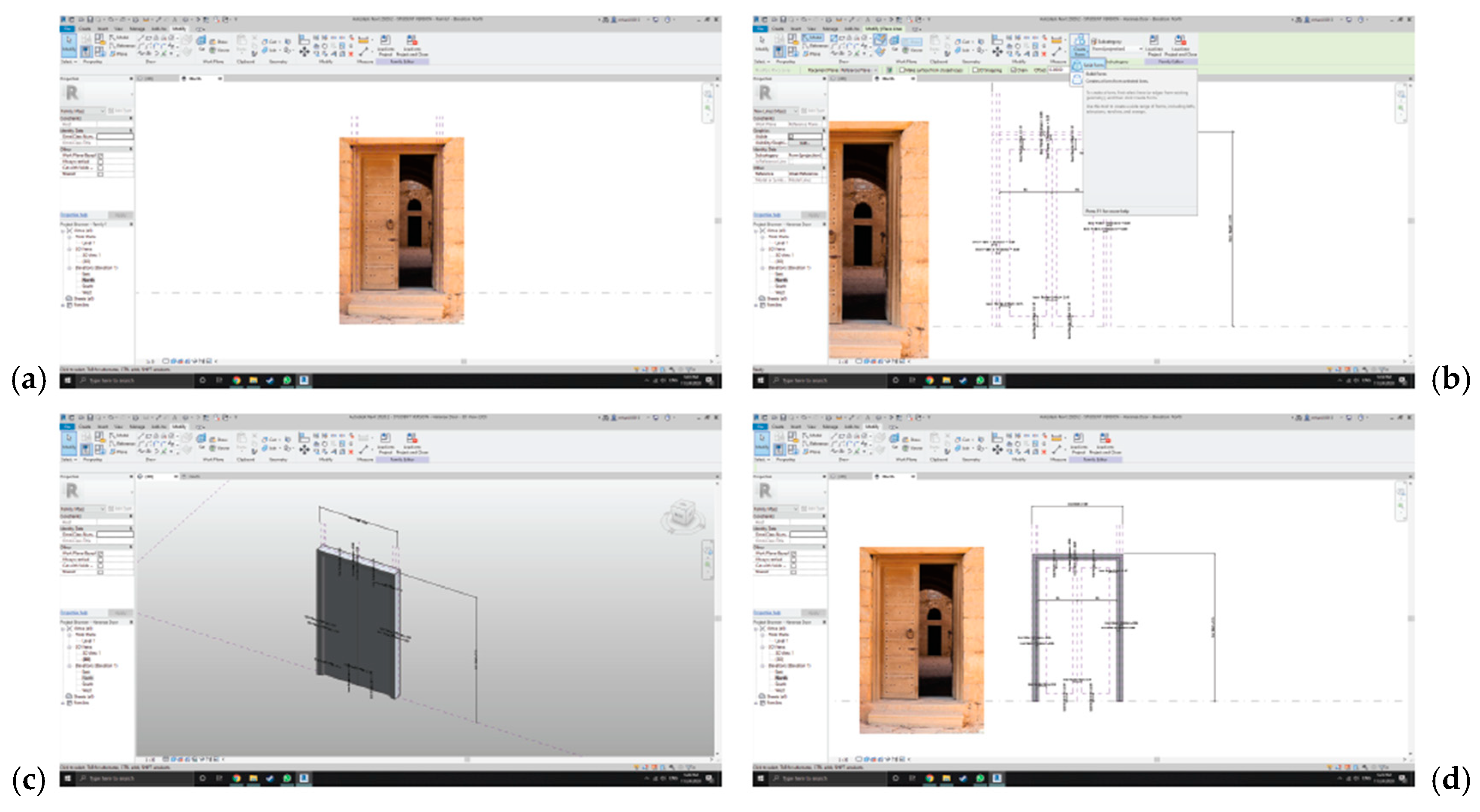
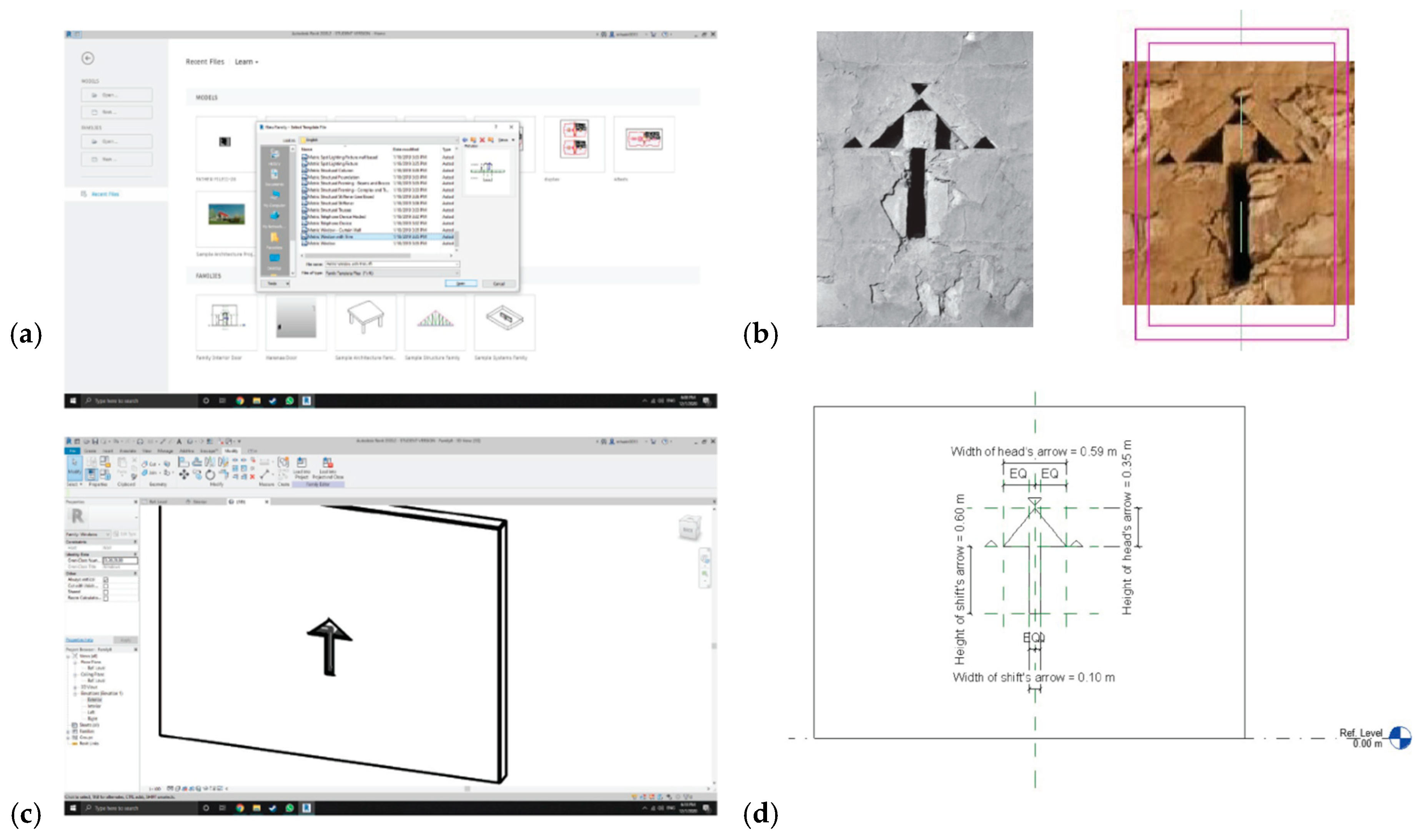
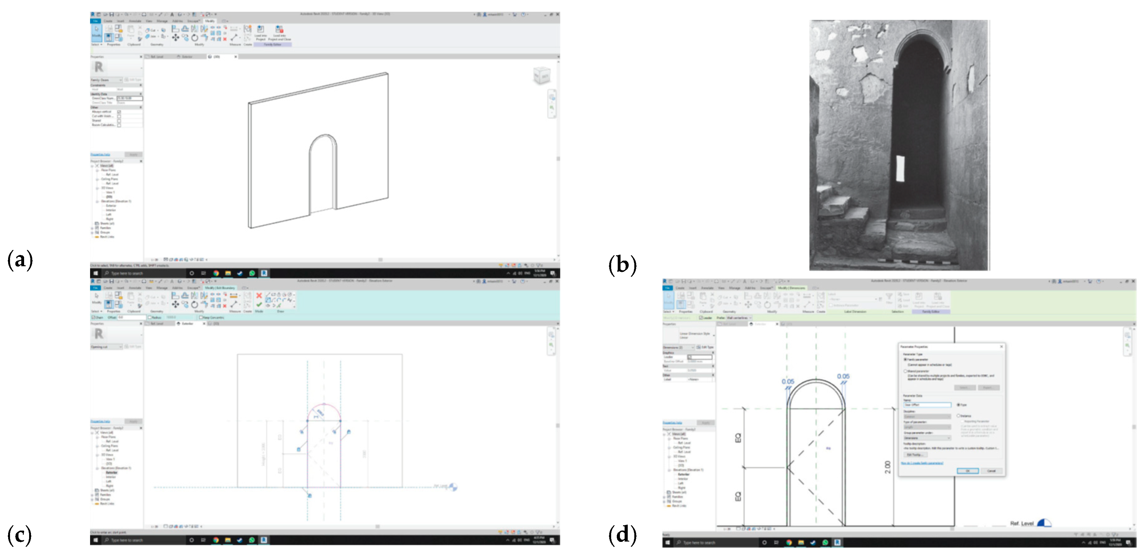
37]. Following data collection, the point cloud was processed using specialized software to prepare the geometric reference for HBIM. The TLS point cloud was used primarily to reconstruct the external envelope, elevations, visible openings, levels, and overall dimensions of Qasr Harrana. Interior spatial divisions and selected internal architectural elements were reconstructed using historical architectural plans, photographic evidence, and architectural interpretation. Therefore, these interior components should be understood as informed HBIM reconstructions rather than direct scan-derived geometry. The modelling process followed a component-based HBIM approach. External walls, openings, arches, vaults, and other architectural elements were modelled as parametric components, with the level of geometric definition adjusted according to the reliability of the available source data. The modelling strategy, corresponding Levels of Development (LOD), Levels of Information (LOI), and the documentation associated with each architectural element are summarized in
Table 1 Where TLS evidence was available, modelling was constrained by the registered point cloud; where TLS coverage was limited, historical drawings and photographic documentation were used as supporting references [
38] (see
Figure 10,
Figure 11,
Figure 12 and
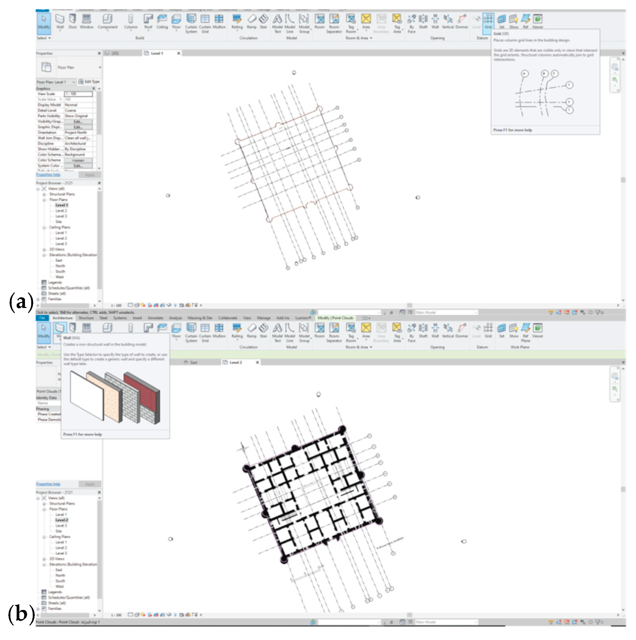
Figure 13). Once the geometric model was completed, selected historical, architectural, material, and condition-related information was integrated within the HBIM environment to support heritage documentation and information management. The principal stages of the HBIM modelling workflow, together with the resulting HBIM model and documentation outputs, are illustrated in (
Figure 14,
Figure 15,
Figure 16 and
Figure 17).
Three representative parametric families were developed and tested within the HBIM environment: arrow-slit openings, entrance gates, and arched doorways (
Figure 10,
Figure 11 and
Figure 12). Each family was constructed using editable dimensional parameters and geometric constraints to facilitate reuse across similar Umayyad architectural elements.
3.4. Integration of Historical Documentation, Architectural Plans, and Construction Details
The integration of historical documentation, architectural plans, and construction details into the parametric heritage model of Qasr Harrana provides a comprehensive understanding of the site’s past, ensuring that future conservation efforts respect its historical significance. This phase enriches the digital model by embedding critical information from a variety of sources to create a holistic representation of both the current state and the evolution of the structure. Historical documentation plays a key role in contextualizing the architectural and structural elements of Qasr Harrana. Archival sources such as historical maps, manuscripts, archaeological reports, and records from past studies offer valuable insights into the original function, design, and the socio-cultural context of the building [
32,
39]. These records are used to reconstruct details about the site’s use during different periods, as well as modifications or repairs it may have undergone throughout its history. For instance, researchers may find references to changes made during particular dynasties or evidence of adaptations to address environmental wear over time. The next component involves architectural plans. These include blueprints or sketches from previous archaeological surveys, structural reports, and conservation efforts. These plans, when aligned with the laser-scanned data, allow researchers to compare how the building has changed from its original design to its current state. For instance, discrepancies between historical drawings and present-day scans can reveal unauthorized alterations or degradation, and this comparison serves as a guide for restoration professionals to make historically informed decisions [
40]. The inclusion of construction details further enriches the parametric heritage mode by documenting the materials, techniques, and craftsmanship that went into building Qasr Harrana. The analysis of the materials used, such as types of stone, mortar, and finishes, provides essential information for planning conservation interventions. Knowing the exact composition of materials used in the original construction enables restoration teams to match materials for repairs, ensuring authenticity in the restoration process. Additionally, studying building techniques offers insight into the construction practices of the Umayyad period, which helps in understanding the structural integrity of the building and predicting potential vulnerabilities. Information regarding previous restoration projects, repairs, and modifications is also integrated, allowing for a layered historical understanding of how the site was maintained or altered over time [
36]. This integration of historical documentation, architectural plans, and construction details creates a rich, multi-dimensional model of Qasr Harrana that is far more than a static geometric representation. It becomes a living archive, allowing future conservationists, historians, and architects to access not only the physical structure’s current state but also its historical significance, construction history, and prior interventions. This dynamic HBIM model serves as a comprehensive tool for both present and future heritage management, guiding informed decisions that honour the integrity of Qasr Harrana’s past while ensuring its preservation for future generations [
41]. The integration of historical documentation, architectural plans, and construction details within the parametric heritage model of Qasr Harrana results in a thorough, context-rich digital representation that not only reflects the building’s physical attributes but also serves as an invaluable resource for the continued preservation and study of this historically significant site.
3.5. Educational Implementation and Interdisciplinary Approach
The proposed Scan-to-HBIM methodology was implemented within a real educational setting as part of an interdisciplinary learning approach. The project was conducted in collaboration between undergraduate students from geomatics and architecture programs. Geomatics students were responsible for the reality-capture phase, including terrestrial laser scanning data acquisition, scan station planning, and initial point cloud generation. This phase was embedded within their surveying and geospatial technology coursework, providing hands-on experience with professional-grade documentation tools. The processed point cloud datasets were subsequently transferred to architecture undergraduate students, who utilized the data as the primary geometric reference for HBIM within a graduation-level design studio. Architecture students developed the parametric heritage model following predefined modelling rules and Levels of Detail and further employed the model to explore adaptive reuse design concepts for Qasr Harrana. This educational structure enabled students to engage with a real heritage site, simulating professional practice by linking survey data production with architectural modelling and design decision-making. This interdisciplinary approach demonstrates how Scan-to-HBIM workflows can be effectively integrated into architectural education, bridging technical reality-capture training with heritage-oriented design studios. Without introducing additional experimental assessments, the approach provides a replicable pedagogical model for institutions seeking to incorporate digital heritage documentation into undergraduate curricula.
4. Results and Discussion
4.1. Presentation of the 3D Model Generated from Laser Scanning
The 3D model of Qasr Harrana generated through laser scanning presents a highly detailed and accurate representation of the monument’s architectural and structural features. The laser scanning process produced millions of data points, forming a comprehensive 3D point cloud that captures the geometric complexity of the site with millimetre-level precision. This model successfully replicates key architectural elements such as the building’s vaulted ceilings, walls, arches, and decorative features, ensuring that even the smallest structural nuances are preserved. The 3D model provides an accurate geometric approach for analysing Qasr Harrana’s current condition. The high-resolution data captures not only the layout but also critical elements like cracks, wear, and surface erosion, which are important for assessing the monument’s structural integrity.
These details, which are often difficult to detect with traditional documentation methods, can be viewed and measured in the digital model, providing valuable information for conservation and restoration planning [
42]. Furthermore, the model offers a detailed view of the building’s spatial relationships and dimensions, enabling architects and conservators to assess areas that are difficult to access physically, such as the upper sections of walls or ceilings. The comprehensive nature of the laser-scanned model allows stakeholders to explore the entire structure digitally, simulating different viewpoints and closely examining areas of interest without the need for physical interaction with the fragile site [
43]. The 3D model also serves as a foundation for future data integration. It supports the incorporation of material, historical, and construction details, which transforms it from a geometric representation into a fully realized Heritage Building Information Model (HBIM). The model provides a structured digital reference for architectural documentation, visual inspection, and future data integration. Its primary value in this study lies in organizing geometric and architectural information in a reusable HBIM environment [
23] (see
Figure 18,
Figure 19 and
Figure 20).
4.2. Analysis of the Current Condition of the Structure Through the Model
The 3D model generated from laser scanning offers a highly detailed and accurate basis for analysing the current condition of Qasr Harrana. By examining the point cloud and photogrammetry data, it is possible to detect areas of structural weakness, such as cracks, surface erosion, and material degradation. The high-resolution model allows conservationists to assess critical points of deterioration on the monument, especially in areas exposed to environmental damage, such as the stone walls and vaulted ceilings [
44] (see
Figure 21 and
Figure 22). Through this analysis, it becomes evident that Qasr Harrana, like many heritage sites, is subject to natural wear, including weathering, erosion, and potential instability in certain sections. The laser-scanned data provides essential insights into the extent of these issues by visually and quantitatively documenting each feature in the model. Cracks in the walls or signs of material stress, for instance, can be measured precisely to determine whether immediate intervention is required to prevent further degradation [
42]. The model also reveals the condition of architectural features such as the arches and courtyards, allowing a comparison between the original design (as inferred from historical records) and the current state.
Within the HBIM environment, these observations can be linked to specific architectural components, such as walls, arches, openings, and vaulted areas. This enables conservation information to be organized at the object level rather than as separate descriptive records. For example, a wall element may include notes on erosion, visible cracking, material loss, or previous repair, allowing future inspections to update the same element and compare its condition over time.
These observations demonstrate the potential of the HBIM model to organize visible condition-related information at the level of individual architectural components. However, the study does not implement a temporal monitoring campaign or structural simulation. The model should therefore be understood as a documentation baseline that may support future inspection, comparison, and conservation planning [
45].
4.3. Heritage Documentation and Information Management
The developed HBIM model demonstrates the value of integrating geometric, historical, architectural, and condition-related information within a single digital environment. By combining TLS-derived geometry, photographic documentation, historical references, and parametric modelling, the workflow produced a structured digital representation of Qasr Harrana that improves the accessibility and organization of heritage information. The resulting model enables users to visualize relationships between architectural components, historical records, material characteristics, and observed condition indicators. This integrated approach facilitates the systematic documentation of heritage assets and provides a consistent digital reference for future research, inspection, maintenance, and documentation activities. For Qasr Harrana, the HBIM model serves primarily as a comprehensive digital archive rather than as a restoration or monitoring system. The model allows heritage information to be stored, updated, and queried within a unified environment, reducing fragmentation across drawings, photographs, reports, and survey datasets. In this regard, the study demonstrates how established Scan-to-HBIM workflows can support heritage information management while improving the long-term usability and accessibility of documentation data. Although the study did not implement conservation interventions, structural simulations, or temporal monitoring campaigns, the resulting HBIM model establishes a digital baseline that may support future conservation planning, comparative studies, and additional documentation efforts. These findings highlight the practical value of integrating reality-capture technologies with HBIM for documenting architecturally complex desert heritage monuments.
5. Conclusions
This study presented a structured Scan-to-HBIM workflow for documenting and managing the architectural information of Qasr Harrana, one of the most representative Umayyad desert palaces in Jordan. The proposed workflow integrates terrestrial laser scanning, photogrammetric documentation, historical architectural drawings, and HBIM within a unified digital documentation framework. Rather than introducing new surveying technologies or modelling algorithms, the study demonstrates how established reality-capture methods can be systematically organized and adapted to support comprehensive heritage documentation and long-term information management. The resulting HBIM model provides a structured digital archive that integrates geometric, architectural, and semantic information within a single environment. This facilitates more efficient documentation management, interdisciplinary collaboration, and future maintenance planning while improving the accessibility and long-term preservation of heritage information. The study also contributes a reusable library of parametric HBIM objects specifically developed for characteristic architectural elements of Umayyad desert architecture, which may support future documentation projects involving similar heritage typologies. The findings further demonstrate that structured Scan-to-HBIM workflows remain applicable even when heritage documentation relies on heterogeneous datasets acquired at different times and using different technologies. Since repeated surveying campaigns are often constrained by accessibility, conservation regulations, permit requirements, or financial limitations, the integration of legacy documentation with contemporary HBIM methodologies represents a practical strategy for many archaeological and heritage documentation projects. Several limitations should be acknowledged. The study employed an earlier-generation terrestrial laser scanner, and the validation focused on practical geometric consistency rather than a comprehensive metrological uncertainty assessment. In addition, the interior spaces of Qasr Harrana were not fully captured using TLS and were reconstructed using historical architectural drawings, photographic documentation, and architectural interpretation. These limitations have been explicitly documented to ensure transparency and should be considered when interpreting the results. Future research should investigate the application of contemporary reality-capture technologies, automated Scan-to-HBIM techniques, and quantitative validation approaches to improve modelling efficiency, geometric completeness, and interoperability. The integration of periodic monitoring datasets and advanced semantic enrichment also represents promising directions for expanding HBIM applications in heritage documentation and long-term conservation management.