


Abstract
This paper explores the intricate relationship between novel paleo-hydrological settings and the sustainability of ancient human societies in the Sahara Desert, focusing on the sandstone massifs of Tassili n’Ajjer, Tadrart Acacus, and Messak Settafet. While this region is currently hyper-arid, archeological evidence reveals a history of significant human settlement facilitated by the African Humid Period (AHP). The core of the research is the idea that the natural geological and hydrogeological settings worked to magnify rainfall in a manner that is analogous to modern techniques in water systems engineering. Serendipitous features of geology, structural settings, and stream networks are presented, along with illustrative calculations to suggest how this system functioned as an accidental rainwater harvesting system, concentrating runoff into conveniently located lakes. On the Messak Settafet, the archaeologic evidence points to a rising water table and more robust groundwater flow as runoff infiltrated. We conceptualize this behavior as a managed aquifer recharge system. This natural system worked effectively by storing ephemeral surface water in a sandstone aquifer, shielded from the high evaporation rates of the Sahara. These “natural technologies” created perennial water sources such as lakes, ponds, and springs that supported hunter-gatherers and pastoralist societies. Long after the end of the Holocene AHP, the Garamantian Empire arose with the help of qanat technology that was able to produce the stored groundwater. This paper illustrates how an unlikely array of components worked to create natural technologies able to provide “livable niches.” These findings offer instructive lessons for modern sustainability, demonstrating how integrated landscape management can secure water resources in water-stressed environments.
1. Introduction
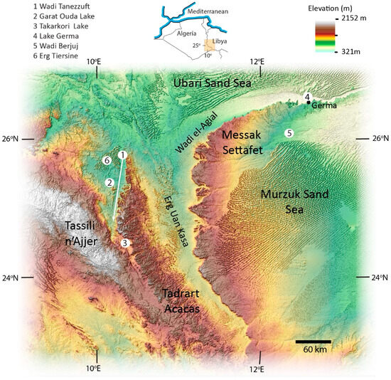
The intimate relationship between societies and water has been known for a long time. Grahame Clark [1], writing in “Water in Antiquity”, noted “the connection between human settlement and sources of water offers a cardinal clue to the location of ancient sites”. Some ancient sites have turned up in what now appear as hot and hyper-arid settings. Remarkable serendipity in hydrologic settings and processes has touched an area of southern Libya and southwestern Algeria. The physical setting includes a piece of the modern-day Sahara Desert, manifested as vast areas of large sand dunes (i.e., called sand seas or ergs), which surround several large sandstone bedrock massifs: Tassili n’Ajjer, Tadrart Acacus, and Messak Settafet (Figure 1). The climate is presently hyper-arid, with large areas lacking vegetation [2]. Despite the modern-day absence of exploitable surface-water resources, human populations living there today can rely on modern technologies to tap old groundwater and irrigation for growing food. Nevertheless, there is archeological evidence of novel processes and settings that provided livable niches for human societies, at least for a while. Potable surface water was widely available across the study area. This area and its rich history should provide instructive lessons for human sustainability in the future.
Figure 1.
The top-center insert shows the location of the study area in northern Africa in parts of Libya and Algeria. Three prominent sandstone massifs are Tassili n’Ajjer, Tadrart Acacus, and Messak Settafet. The list shows the locations of wadis, ergs, and lakes of interest.
In the past, the key driver for kick-starting the hydrologic cycle there was precipitation, associated with the most recent African Humid Period (AHP). Following the last Glacial Period, the warming climate of the Early Holocene (starting 11.7 ka BP) coincided with an intensification of the West African summer monsoon. This event increased precipitation with incursions of moisture northeastward into the Sahara Desert. Widespread increases in rainfall in northern Africa transformed the desert into grasslands and wooded grasslands with lakes, rivers, and abundant plants, wildlife, and human settlements [2,3]. In our area of interest (Figure 1), the most recent AHP persisted through the Early Holocene (11.7 ka BP to 8.2 ka BP) and much of the Middle Holocene (8.2 ka BP to 4.2 ka BP).
By itself, this event might seem to be all that was needed for humans to succeed in this setting. However, because this area was close to the northern limit of monsoon incursion, precipitation was relatively limited, averaging~250 mm/yr through the Early and Middle Holocene. It was delivered during a three-month summer rainy season [2,4]. More detailed archaeologic assessments of precipitation suggest that rainfall was significantly higher near the start of the Holocene. For example, dating of spring-associated deposits in the Tadrart Acacus Mountains (Figure 1) indicated higher rainfalls from 9.6 ka BP to 8.1 ka BP [5]. Deposits associated with groundwater discharge in Wadi (valley) el-Agial (Figure 1) provided a range from ~11 ka BP to ~8 ka BP [3]. Rainfall declined into the Middle Holocene with significant aridity evident around 6.5 ka BP [3]. Final desiccation was marked by the drying of Paleolake Shati, located north of the study area, in 5.3 ka BP [3], and small inter-dune lakes in Erg Uan Kasa at 5.0 ka BP [6].
In this study, our first objective is to show how human settlement during the Early and Middle Holocene depended on a windfall of novel hydrologic settings, which collectively provided local availability of natural water sources for Epipaleolithic, Mesolithic and Pastoral-Neolithic cultures.
A second objective is to elucidate how serendipity in the settings extended to an ancient society, which used a novel technology to cope with hot, arid conditions that returned after the Holocene AHP ended. The Garamantian Empire (400 BCE to 400 CE) featured eight populated towns and larger settlements [7]. The Garamantes controlled an area of about 180,000 km2 with Garama (sometimes written as Jarma, or Germa) as its largest city with a population of 4000 [7]. The ascendancy of the Garamantian Empire was unusual given a climate comparable to the modern-day Libyan Sahara Desert with virtually no rainfall and a few saline lakes. Nominally, present-day annual precipitation in the Fezzan is 10 mm/yr with some years with no rainfall recorded [8]. The existence of the Garamantian State marked the first time an urbanized society thrived in any part of the Sahara or other major deserts without a perennially flowing river [7]. Unlike earlier societies, Garamantians relied on a technological advance creating an ability to produce groundwater. The result was a “water windfall” capable of increasing the population carrying capacity in a place where it otherwise would be negligible. Yet, this water windfall appears to be serendipitous in ways that are discussed in the paper.
The concept of “novel hydrology” provides a framework to discuss the serendipitous processes and features that made human occupation possible during Early and Middle Holocene and more recent times. The novelty of the situation in this study area will be evident as compared to other parts of the Sahara Desert where reliable water supplies existed for millennia. Examples include oases associated with perennial spring discharge from large, regional groundwater flow systems or the serendipitous presence of the Nile, the world’s longest river.
1.1. Overview of the Physical Setting and Human Societies
1.1.1. Terrestrial Hydrologic Cycle
One feature associated with this place and time was the evolution of humanity’s relationship with water, from passive acceptance of whatever water was contributed by natural processes, e.g., rivers, lakes and springs, to proactive exploitation of stored groundwater in the absence of a functional water cycle. AHPs represent times when rain was potentially available. The rains of the West African Monsoon over land are caused by insolation or heating by the sun. In summer, solar heating on land triggers convective cycling of warm air upward and toward the cooler ocean. Cooler, moisture-laden air from offshore is cycled onto land creating monsoon rainfall. In winter, the cycle reverses to cause a long dry season.
AHPs featured stronger solar heating, creating greater precipitation and deeper rainfall incursions into the region of the present-day Sahara Desert. They occur about every twenty thousand years as determined by orbital precession or changes in the orientation of the Earth’s axis [9]. However, the intensity of summer heating during an AHP is variable, leading to stronger or weaker monsoon rains. For example, with the most recent, Early Holocene, wetting of the Sahara was relatively weaker in relation to a very strong AHP that occurred during the last interglacial (Eemian) 128–122 ka BP [10]. Variability in rainfall intensity with the West African Monsoon is influenced by other factors that include vegetation, dust, the presence of large lakes, ocean–atmosphere interactions and potentially changes in land use [9].
Redistribution of rainfall is accomplished by runoff and infiltration at the land surface. The sandstone bedrock massifs are important elements of the water cycle. They include Messak Settafet, Tadrart Acacus, and Tassili n’Ajjer (Figure 1). Perego et al. [11] published a detailed geomorphic map of Messak Settafet using Landsat imagery and digital elevation from the SRTM (Shuttle Radar Topography Mission). This flat, arc-shaped plateau (Figure 1) is approximately 350 km long and 60 km wide with a maximum elevation of 1300 m asl. It is comprised of exposed sandstone of Cretaceous age with a dense network of dry, paleo-stream channels (wadis) that contain fluvial sands and gravels that were mapped in detail [11]. A 300 m high escarpment along western and northern edges of Messak Settafet towers over Wadi el-Agial to the west. The town of Germa (Figure 1) that is situated in the valley at the bottom of the escarpment was important during Garamantian times.
Tadrart Acacus Mountains rise to an elevation of 1300 m asl (Figure 1). Bedrock comprises a sequence of Lower to Middle Silurian shale overlain by sandstone. These rocks have been heavily eroded by surface water in the past [12]. The terrain featured small caves and rock shelters, which were important to human groups [5]. The western margin of the Tadrart Acacus is a steep escarpment bounding the important Wadi Tanezzuft (Figure 1). To the east, the massif slopes more gently and transitions to the Erg Uan Kasa, a “sea” of sand.
The Tassili n’Ajjer Mountains have an areal extent of 72,000 km2 with maximum elevations ranging between 1500 and 1800 m asl. This area is known for its prehistoric art that consists of thousands of engravings and paintings [13]. The art chronicles the life of human groups from 12 ka BP to the first centuries CE. Higher elevations host an upland plateau comprised of sandstone. It has been dissected by deep gorges and spectacular erosional features such as arches and clustered rock pillars or “forests of stone” [13]. Scattered Saharan cypress trees occur in gorges at higher elevations, along with a few permanent water pools in the northern Tassili [13].
There are many named wadis large and small. During AHPs, these were part of a natural paleohydrologic “rainfall harvesting system” (RHS) with stream and river networks [3]. Presently, these valleys are dry year-round. The only freshwater sources are small ponds or “gueltas” in mountain areas that collect runoff from rare storm events [14]. Saline lakes in the desert west of Germa mark discharge areas for regional flow systems.
Two wadis, Wadi el-Agial and Wadi Tanezzuft are particularly relevant to this study (Figure 1). Drake et al. [3] identified rivers and lakes associated with these wadis during AHPs. Streams draining the Tadrart Acacus Mountains flowed eastward into Wadi el-Agial. Much of that drainage ended up in a river 620 km long, which flowed northward and east to Lake Germa. This lake also received discharge from groundwater flow systems associated with Messak Settafet [3].
Wadi Tanezzuft (Figure 1) is a relatively narrow valley approximately 150 km long that is bounded on the east by an escarpment of the Tadrart Acacus and on the west by Tassili n’Ajjer. During AHPs, streamflow within the wadi was associated with tributaries that drained large upland areas of the Tassili n’Ajjer. The wadis draining the Tassili n’Ajjer were locally entrenched, sometimes forming deep gorges. Additional contributions came from a few smaller catchments rising in the Tadrart Acacus to the east.
During the Early and Middle Holocene AHP, river flows in Wadi Tanezzuft and direct inflows from wadis on the northern Tassili n’Ajjer supported Garat Ouda Lake, which had an area of approximately 90 km2. The lake supported fish, crocodiles, and hippopotamuses [15]. The Wadi Tanezzuft River ended approximately “60 km north of the northern fringe of the Tadrart Acacus massif” [15]. Today, rare mountain storms can generate short-term flows in the Wadi Tanezzuft River [15]. Upstream areas at high elevations in the Tassili n’Ajjer Mountains can contain permanent pools of water [13].
Within the area of interest, there are two large, expansive desert dune areas, the Ubari Sand Sea and the Murzuk Sand Sea (Figure 1). Erg Uan Kasa is a smaller area of desert sands located east of the Tadrart Acacus massif. Here, the dunes occur as a complex of sub-parallel ridges [12]. During the wettest periods of AHPs, rainfall was often sufficient to create small lakes in the corridors among the dune ridges.
All the upland massifs have sandstone as the uppermost bedrock unit and are aquifers. These groundwater systems are complicated, and their hydraulic parameters are not known. In the Tadrart Acacus Mountains, sandstone units overlying the Tanezzuft Shale facilitated the downdip flow of groundwater eastward toward Wadi el-Agial [5].
Our study also examines groundwater resources and flow systems associated with the western Murzuk Basin (Figure 1). Shallow bedrock dips and thickens toward the middle of the basin. The sandstone aquifer, the Messak Fm (Cretaceous), overlies a confining bed, the Taouratine Fm (Jurassic) [16]. The Messak Fm exposed in the western escarpment (Figure 1) is about 400 m thick. This formation is the uppermost bedrock, across about three-quarters of the Murzuk Basin, but covered by dune sand. The upper member of the Messak Fm. forms the bluff at the top of Messak Settafet Escarpment.
1.1.2. Evolution of Human Societies
Human occupation has been intimately related to the availability of water associated with the AHPs. More than 230 AHPs have been identified in the past 8 million years [2]. Preceding the Holocene, dry periods were interrupted by AHPs from approximately 75–81 ka BP, 97–105 ka BP and the strong Eemian event, 122–128 ka BP [10]. In our area of interest, most archeological artifacts are attributed to Holocene societies 10 ka BP and younger. However, several sites (cave and rockshelter) in the Tadrart Acacus indicated Middle Stone Age occupation during the late Pleistocene 69 to 90 ka years BP [17,18]. The intervening 45,000 years to 15,000 years BP were dry without human occupation [18], except for local refugia provided in the bedrock massifs. With the initiation of the AHP at the beginning of the Holocene, more favorable climatic conditions favored human occupation of the area until severe drying set in about 5 ka BP.
Only localized areas were favorable for human occupation with necessary resources of water and food. The estimated wet-season rainfall, averaging 250 mm (~10 inches) was not broadly compatible with human occupation. The Holocene AHP was noteworthy for a shift from mobile groups of hunter-gatherers in the earliest Holocene to more established settlements and processing of plants at 8 ka BP to 7 ka BP [15]. From 7 ka BP to 5 ka BP, pastoral neolithic cattle-herders adapted to the seasonality of the humid climate through local migration. In the summer rainy season, herders tended to live around dune-field lakes of the Erg Uan Kasa and western edge of the Murzuk Sand Sea. During the dry season, they moved to adjacent mountain upland areas, in the Acacus and Messak massifs, respectively [19]. Similar dune-field lake settings, albeit smaller, Ergs Tanezzuft (Figure 1) and Titersine, bordered Wadi Tanezzuft [20]. However, unlike most other settlement systems humans there took significant advantage of perennial water resources. These benefits came from Garat Ouda Lake and its associated river deltas, and alluvial plains watered by the “almost year-long” flows of the river within Wadi Tanezzuft [20]. However, as the drying developed toward the end of the Middle Holocene, populations of humans, and wild and domestic animals likely declined.
With the waning of summer monsoons after 5 ka BP, the climate also became much less favorable for human groups in Wadi Tanezzuft [20]. About that time, dune-field lake systems associated with the ergs and sand seas disappeared along with Garat Ouda Lake [6,17]. As the water disappeared from these traditional areas of settlement, populations declined [20]. Fortunately, in Wadi Tanezzuft, river flows continued to support a small oasis 80 km long and 10–15 km wide for 2000 more years until about 3 ka BP [20]. River flows were likely groundwater baseflow from bedrock aquifers within the basin [20]. By approximately 2 ka BP, Wadi Tanezzuft was a small oasis, a stop on caravan routes [15].
The Garamantian Empire emerged long after the end of the Holocene AHP. Although groundwater was initially available in dug wells, those sources could not have been developed sufficiently to support the large system of irrigated agriculture upon which the Garamantian Empire was founded [8]. Their empire developed around a novel tunnel-based technology for extracting groundwater from alluvial fans and moving it by gravity to ground surface in valleys below. Foggara or qanat technology was developed in Persia or Arabia about 2.5 ka BP and spread rapidly through southwest Asia and North Africa [21]. In the study area, this water windfall created an impressively large human carrying capacity, likely unprecedented for this region.
Foggaras were dug by hand using hand tools and windlasses. More than 530 foggaras were constructed along a 160 km stretch of Wadi el-Agial [8], reflecting the large scale of irrigated agriculture and a relatively large population density. Foggaras were more numerous in the vicinity of Garamantian settlements. More broadly across the Fezzan, the number of foggaras likely exceeded 600. Considering the arduous and dangerous character of the work to construct and maintain this large system of foggaras, slave labor was likely involved [8].
2. Methods
Published archeological studies of human occupation and societal evolution from years of detailed investigations guided our study. These works focused on Wadi Tanezzuft, the Tadrart Acacus Mountains and nearby dune fields of Erg Uan Kasa, Messak Settafet, Wadi el-Agial, along the escarpment and especially near Germa, and western areas of the Murzuk Sand Sea (Figure 1). Published analyses of archeological evidence from a hydrogeological perspective provided information on population behaviors as a function of time as well as surface-water and groundwater features.
The Digital Elevation Model (DEM) was prepared using Shuttle Radar Topography Mission (SRTM) data [22]. The 3 arc-second data provide grid points spaced ~90 m apart. ArcGIS mosaicking tools [23] were used to merge and align four DEM data tiles (in Geotiff format) for elevation visualization of the study area. Geological studies were associated with oil and gas-related exploration and drilling. These studies provided information on stratigraphy and basin architecture.
2.1. Modeling Framework and Experimental Design
Runoff dynamics from Early and Middle Holocene (~11.4 to 5 ka BP) were investigated using the Soil Conservation Service Runoff Curve Number (SCS-CN) model [24]. This approach is commonly considered to be associated with studies of small agricultural basins. However, it has been extended to larger domains and more diverse physical settings [25] and particularly large-scale, arid-zone studies [26]. The inherent simplicity and parsimonious data requirements align well with deep-time studies like ours, with largely empirical information. Given the absence of precipitation and streamflow data for calibration, the model is implemented not in a predictive mode, but within an illustrative, scenario-based bounding framework. A description of the structural parameters of this experimental design follows.
Inclusion criteria associated with input data and parameter ranges were selected based on paleo-environmental feasibility and regional geomorphological constraints. Lacking direct physical measurements from the Early Holocene, curve numbers (CNs) and precipitation thresholds were selected using two primary criteria: (i) modern geographical and meteorological analogs of monsoon-driven climates and (ii) bounded expert consensus archeological evidence associated with early-Holocene paleoclimate and hydrological settings.
The spatial coverage focuses on primary runoff-generating areas, specifically the three prominent mountain massifs the Messak Settafet, the Tadrart Acacus Mountains, and the Tassili n’Ajjer. Because this deep-time simulation is illustrative, the spatial resolution utilizes a macro-catchment, semi-distributed scale. This approach allows the model to capture the broad regional hydrological connectivity and the drainage behavior of the mountain massifs without over-interpreting settings that cannot be validated in the paleo-record.
The boundaries of basins draining Messak Settafet were defined using Google Earth imagery that displayed obvious relict drainage networks. Given the watershed boundaries, their areas were determined by a graphical approach. For the Tassili n’Ajjer, a similar approach was followed using a topographic map that included paleo-drainage networks [27]. This map was also used for the Tadrart Acacus massif. However, it was difficult to define drainage networks there because of extensive dissection by erosion. Consequently, with the Tadrart Acacus runoff was estimated for four large areas.
2.2. Parameter Uncertainty and Scenario Matrix
Because the model cannot be calibrated against observed discharge, conflicting parameter inputs and inherent model non-linearities were expressed as scenario uncertainty bounds rather than forced into a single “best-fit” configuration. We systematically cross-analyzed four distinct curve number scenarios against “less intense” and “more intense” storm sets, resulting in an 8-block simulation matrix (Table 1). These two storm sets provide two different translations of modern storm measurements from the Sahel [28] backward in time.
Table 1.
Matrix of illustrative modeling scenarios.
Modern-day rainfall measurements for the Sahel of West Africa provide a useful analog for Holocene wet-season rainfall. Present-day, monsoon rainstorms manifest themselves as squall lines over a few days [28]. During the rainy season, daily precipitation is variable with many (i.e., 40–50) small events, and two to four extreme events. Modern-day analyses conceptualized runoff as driven by extreme events based on three categories of extreme events that averaged 47 mm/d, 75 mm/d and 125 mm/d [25]. Toward the northern extent of the modern monsoon, the lowest category of events dominated with rare occurrences of the highest category [28]. Extreme events in the Sahel typically deliver the greatest proportion of modern-day precipitation [28].
In our study, we considered these small events to be of little practical significance. These events have not been well characterized in terms of characterizations of amounts of rainfall delivered in individual storms. Moreover, calculations with the SCS-CN runoff model showed negligible to no runoff for events below 15 mm with CNs above 80.
A variety of proxy data suggest that the Early Holocene was wetter than Middle Holocene with accelerated drying after approximately 6 ka BP to dry-out at about 5 ka BP. This decline in precipitation is modeled by a reduction in the number of more extreme storms and the number of storms generally.
Our analyses involved two sets of annual extreme events. The first, more intensive storm set utilizes the three categories described above. A second, less intensive storm set with categories 25 mm/d, 50 mm/d and 75 mm/d represents intensities ~60% of the more intensive set. This arbitrary reduction reflects the possibility of reduced intensity in monsoonal storms much farther north. Table 1 presents our design of calculational scenarios. Uncertainty in the estimates of rainfall associated with annual extreme events is assessed with the use of the more intense storm set with four scenarios with varying CNs. The second group of four scenarios is based on the less intense storm set with the same variation in CNs.
The matrix design (Table 1) explicitly accounts for a known structural limitation of the standard SCS-CN framework, which is associated with the initial abstraction threshold. With the less intense storm set, higher curve numbers, bordering on unrealistic, are required to initiate runoff. Small rainfall depths resulted in less runoff because of the model’s static abstraction threshold. Conversely, with the more intense storm set, larger precipitation volumes easily overwhelmed this threshold allowing lower, more physically realistic curve numbers to produce comparable flow volumes. Rather than selecting one single scenario, this matrix design transparently establishes lower and upper bounding limits of the region’s runoff potential.
2.3. Parameter Uncertainty and Sensitivity Analysis
In the absence of observed Early Holocene streamflow data, a traditional statistical error analysis is not feasible. Instead, model uncertainty and potential error propagation were quantified using an extreme-bounds sensitivity analysis [29]. One primary source of epistemic uncertainty in this illustrative model stems from errors in the estimation of precipitation. In our analysis, this issue is addressed by contrasting the less intense and more intense storm bounds, capturing the likely range in paleoclimate proxy estimates. Another source of error is parameter estimation error for CN values. This uncertainty is evaluated by assessing values across a logical range (CN 95 to CN 70) from somewhat permeable and possibly vegetated surfaces (lower CN values) to bare-rock massifs (higher CN).
The standard SCS-CN equation [24] describes runoff non-linearly:
where R is runoff and S is the maximum depth of water retained in the watershed. Values of S are determined as a function of curve number (CN), i.e.,
with values typically ranging from 20 to 100 as a function of soil type, land use, and antecedent moisture conditions [24]. Accordingly, any error or “guess” in the selection of a Curve Number propagates exponentially when rainfall (P) is small. By systematically shifting parameters across our 8-block matrix, we map the envelope of mathematical uncertainty. The variance between the minimum scenario (Scenario 1) and maximum scenario (Scenario 8) serves as the formal boundary for model error, ensuring that the true, unmeasurable historical runoff volume remains contained within our reported results.
Table 2 depicts how total rainfalls applied to each area from extreme events are calculated. Each of the time intervals, e.g., 11.4–8.2 pairs three categories e.g., C1 = 25 mm, C2 = 50 mm of extreme events with the frequency of events in this category e.g., f1 = 3 f2 = 1 etc. The extreme rain total is the sum of the products (e.g., C1∙f1) of the three paired values. The table has annual values for both the less intense storm sets and the more intense storm sets (Table 2). The totals for the light rains are unconstrained estimates assuming a Holocene AHP rain total (extreme events + light rains) averaging about 250 mm with higher total rains from 11.4–8.2 ka BP and lower values from 6.4–5.0 ka BP.
Table 2.
Summary of the frequency of extreme storm events in each of the categories and the rainfall totals for the extreme component as a function of time and storm intensity.
3. Results
Satellite imagery and geomorphic maps of the Messak Settafet [11], Tadrart Acacus Mountains [12], and Tassili n’Ajjer [27] show paleo-stream networks eroded into bedrock on the backslopes of the massifs. The formation of these channels is associated with the wetter climates of the Tertiary and Early Pleistocene [17]. Friable, soft sandstones of the Tadrart Acacus Mountains were markedly dissected by deep, sandy wadis at lower elevations.
During the summer months of the Holocene AHP, topographic gradients on the backslopes of these massifs drove a hydrologic cycle where precipitation created runoff that flowed downhill with overland flow, along with groundwater flow associated with infiltration into sandstones and sands. All three sandstones are permeable to some extent and were capable of transmitting groundwater.
Rivers flowing in Wadi Tanezzuft, Wadi Berjuj and Wadi el-Agial (Figure 2) received runoff during the Holocene AHP from upland areas of the sandstone massifs. With all three massifs, most of the surface runoff occurred on the back slopes. Runoff on front slopes, commonly escarpments, was negligible. For example, Wadi Tanezzuft likely received more runoff from the uplands of the Tassili n’Ajjer than from the southwestern side of the Tadrart Acacus Mountains. Similarly, most of the inflows to Wadi el-Agial were from the Tadrart Acacus Mountains to the west (Figure 2). Only minimal runoff in Wadi el-Agial came from the Messak Settafet to the east and northeast.
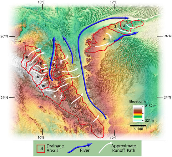
Figure 2.
Digital elevation map showing 17 drainage areas associated with the bedrock massifs. Associated with Messak Settafet are Areas 1–4, which contributed runoff to a river in Wadi Berjuj that flowed northeast. Runoff from Tadrart Acacus Mountains (Areas 6–8) and from (Area 9) fed a large river in Wadi el-Agial, which terminated in Paleo Lake Germa [3]. Runoff from Area 5 drained to the NNW. The large river in Wadi Tanezzuft received runoff from a large portion of the Tassili n’Ajjer Mountains (Areas 10–16) and a small piece of the Tadrart Acacus Mountains (Area 17).
Watersheds or larger areas of interest were identified in the uplands of the three sandstone massifs (Figure 2). Each area is identified by a number. The white-colored arrows show the approximate directions of overland flow down the topographic gradient. The course of major rivers flowing during the Holocene AHP is shown approximately with blue arrows. Of interest here are rivers in Wadi Tanezzuft (1), Wadi el-Agial (2) and Wadi Berjuj (3) (Figure 2). Runoff from four areas of interest (1–4) on the back slope of the Messak Settafet (Figure 2) accumulated as a river generally flowing from west to east in Wadi Berjuj.
The longest of the rivers that flowed in Wadi el-Agial received runoff from large areas (6, 7, 8) on the back slope of the Tadrart Acacus Mountains and a portion of the Tassili n’Ajjer, area (9) (Figure 2). Flows in this river, together with groundwater discharge at the base of the Messak Settafet, supplied water to the terminal lake at Germa (Figure 1) [3]. Runoff from the back slope of the northern end of the Tadrart Acacus Mountains (area 5, Figure 2) contributed to a stream flowing north-northwest (Figure 2).
Areas of the Tassili n’Ajjer contributing to river flow in Wadi Tanezzuft are subdivided into seven drainage areas informally numbered 10 to 16 (Figure 2). Except for area 10, water from areas 11 to 15 contributed to maintaining water in Garat Ouda Lake. Some of the runoff from area 10 would have been stored in small lakes associated with Erg Tiersine. Additionally, a relatively small area of the front slope of the Tadrart Acacus Mountains (area 17) also contributed runoff to Wadi Tanezzuft.
Runoff was estimated for each of the eight scenarios listed in Table 1, which represent two different rainfall intensity sets, four less intensive and four more intensive. Each set of scenarios used four CNs that span the logical range. We started with a set of relatively low CNs (Table S1) that were stepped up by 5 with each of the three other scenarios in that set. For example, with Wadi Tanezufft, CN values began with approximately 80 in Scenario 1 and increased to 95 in Scenario 4 (Table S1). As the results indicate (Table S1), there was no need to test lower values of CNs. The relatively small rainfall amounts there could not overcome the static threshold for runoff generation associated with even lower CNs. The relatively smaller CN values for areas contributing runoff to Wadi el-Agial (Table S1) are assigned assuming greater infiltration through porous sandstones of the Tadrart Acacus (areas 6–8) and for area 9 the reduced topographic gradients and increased available surface storage.
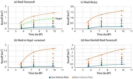
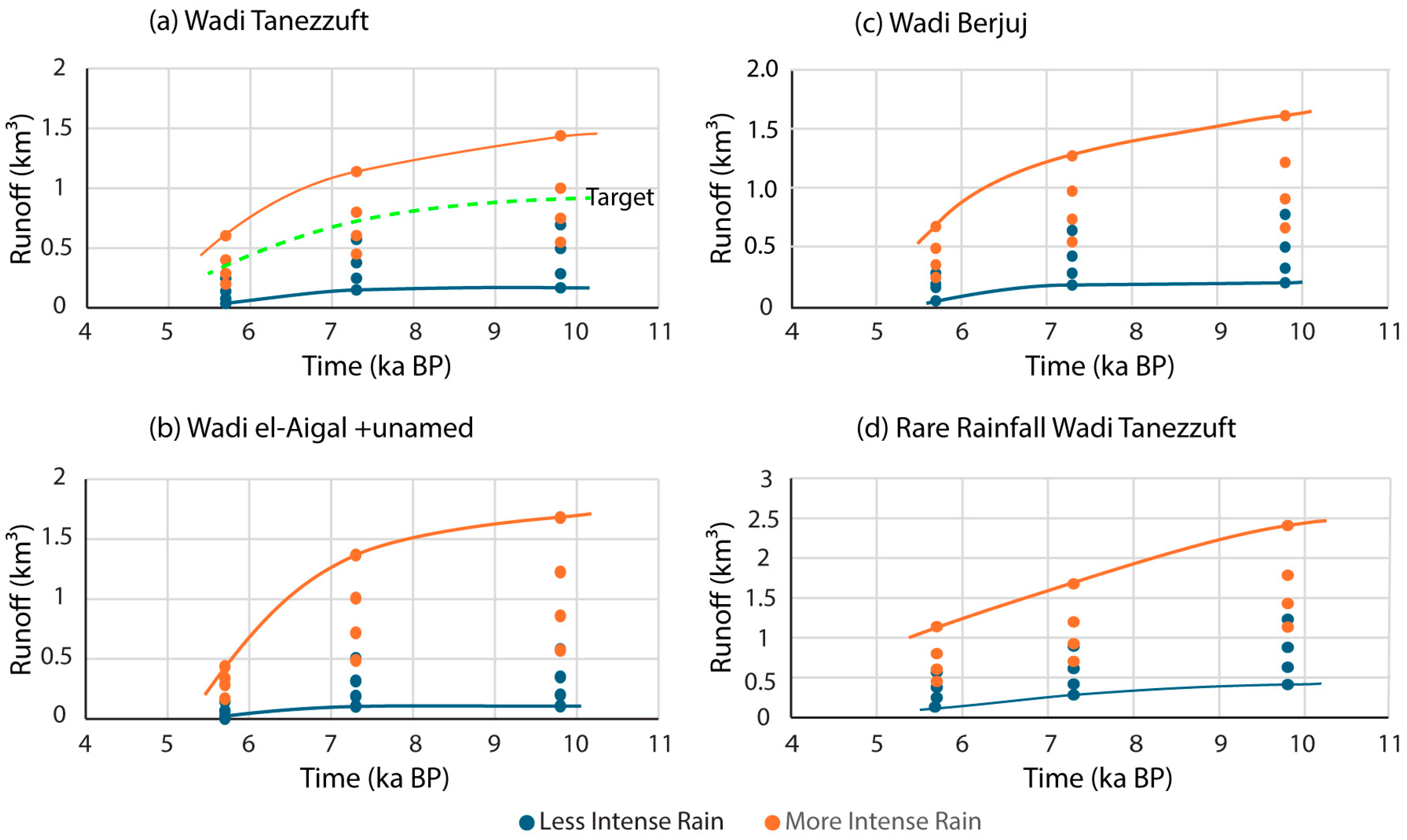
Figure 3 shows calculated runoff into Wadi Tanezzuft (Panel a), Wadi el-Agial plus the unnamed wadi (Area 5) (Panel b), and Wadi Berjuj (Panel c). Figure 3d shows the estimated runoff into Wadi Tanezzuft due to a rare runoff event. In Figure 3, the orange lines represent the upper bounds that result from a combination of the highest CNs and the more intense rainfall set. The lower bound (blue line) represents the effects of the less intense rainfall set together with relatively low values of the curve numbers. The dashed green line (Figure 3a) approximates the runoff in Wadi Tanezzuft given the constraint for Garat Ouda Lake discussed in the next section. The rainy season runoff estimate at 5.7 ka BP (Figure 3a) was constrained to a minimum value approximately 0.4 km3, which provided 0.3 km3 of available runoff to Garat Ouda Lake. Twenty-five percent of the runoff to the wadi was unavailable to the lake.
Figure 3.
Calculated rainfall runoff into (a) Wadi Tanezzuft, (b) Wadi el-Agial and an unnamed wadi, and (c) Wadi Berjuj. The dashed green line in Panel (a) is the target runoff based on the constrain with Garat Lake Ouda. Panel (d) is a rare extreme flood event in Wadi Tanezzuft.
As expected, runoff volumes declined through the Early and Middle Holocene due to a reduction in the number and magnitude of extreme events (Figure 3). The variability in the calculated runoff is relatively large at 9.8 and 7.3 ka BP due to the expressed uncertainty in values of CN and storm intensity. With Figure 3, readers can appreciate the illustrative character of simulations given the large uncertainty in primary variables. The results at 5.7 ka exhibit less variability because most calculations are affected by runoff thresholds reducing surface runoff in scenarios with CN values less than 80 or smaller, especially for Wadi el-Agial (Panel b). However, infiltration on the Tadrart Acacus probably led to additional groundwater contributions to stream flows and dunal lakes on the lower back slope of the mountain.
Although results are uncertain, the bedrock massifs have potential for runoff generation. For example, a cubic kilometer of water, a reasonable example of wet season flow in each of three wadis, would provide an equivalent 100-day streamflow of 115 m3/s (~4000 ft3/s). With the rare event (Figure 3d), flooding might have been significantly larger.
Evaluation of the Runoff Estimation Approach
Given the absence of historical measurements of the hydrologic cycle, rigorous assessment of the validity of the runoff estimates in Figure 3 is not possible. However, there are certain hydrologic constraints that provide a basis for the evaluation of the runoff calculation. Garat Ouda Lake in Wadi Tanezzuft contained water continuously from 11.4 ka BP until dry-out at about 5 ka BP. Thus, inflows to the lake needed to be sufficient to initially fill it and reliably replace water lost by dry-season evaporation. Fish and crocodiles in the lake in the Early Holocene would not have survived repeated dry-outs. Moreover, sufficient additional runoff would need to be available to provide the river-flows northward, known to have occurred far into the desert [15].
Our zero-order approximation assumes that inflows to the lake came from surface runoff and that outflows were due to dry-season evaporation. Possible inflows or outflows of groundwater could not be assessed with the available data. However, with estimates of runoff from the adjacent massif and losses due to dry-season evaporation, we estimated the runoff required to maintain Garat Ouda.
A detailed study of human diets associated with the Takarkori rock shelter revealed the drying history of a nearby lake, up-valley from Garat Ouda Lake, which was inferred from species of fish and amphibians, and the mix of food sources [30]. Indications are that this lake along with Garat Ouda Lake was permanent and held water through the 8.2 ka BP drying event [30]. Towards the end of the Middle Holocene at 5.5 ka BP indications were that water levels were low and fluctuating, at Takarkori before both lakes dried out.
Elevation estimates in and around the present-day dry basin of Garat Ouda indicated that the lake was approximately 7 m deep. Given an area of 90 km2 the estimated capacity of the lake was ~0.63 km3. The total runoff numbers for Wadi Tanezzuft in Figure 3a need to be reduced by 25% because area 10 did not contribute substantially to Garat Ouda Lake.
Our estimate of water losses at Garat Ouda Lake due to evaporation came from a satellite-based study [31]. That study documented water-level fluctuations of 42 present-day ponds, lakes and reservoirs in the Central African Sahel, Mali, Burkina Faso, and Niger. These numbers are geographically and climatologically relevant to our study with high-resolution data collected over a 5-year period. Water-body stages fluctuated within an annual cycle, from a maximum water level due to wet-season contributions to a minimum reflecting evaporation through a long dry season [31]. Evaporation rates averaged 5.66 mm/d across their study area. In the north with less rainfall, rates were higher averaging 7.04 mm/d [31]. Applying this 7.04 mm/d value to Garat Ouda Lake, evaporation for 273 days would reduce the lake stage by 1.9 m. The volume loss due to evaporation would be approximately 0.17 km3.
Of the runoff to Wadi Tanezzuft (Figure 3), 75% was available to Garat Ouda Lake. The green dashed line describes the lower limit of runoff with the more intensive storm set, which was always capable of producing a water excess in a typical year to both refill the lake and provide for some river flow. In the interval, 6.4–5.0 ka BP, the quantity of runoff available for the lake was only about 1.5× the needed replacement volume. In contrast, considering the larger rainfall amounts of Early Holocene, runoff available to Garat Ouda Lake would be 4.5× the water needed to replace the evaporated water.
The runoff estimates for Wadi Tanezzuft in Figure 3 were sufficiently high to support Garat Ouda Lake as a permanent lake from 11.7 to 5.0 ka BP. However, approaching 5.0 ka/BP it is reasonable to anticipate its inevitable extinction. While the Early Holocene numbers for runoff maxima certainly could create significant flooding, values are not constrained. Literature suggests the Early Holocene was noticeably wetter than later times [3,5]. Our estimate for a typical year in the Early Holocene was effectively higher through the addition of one extreme event of 25 mm/d, which we consider to be modest.
4. Serendipity Working for Ancient Societies
Rainfall associated with the Holocene AHP was foundational in creating niches for humans during the Early and Middle Holocene. However, although rainfall was necessary to create a hydrologic cycle, by itself, it was not sufficient because rainfall amounts were relatively small. Fortunately, layers of serendipity were available to ameliorate this deficiency.
4.1. Accidental Rainwater Harvesting System
Rainwater harvesting systems (RHSs) represent a set of historically important technologies that have provided water for human societies faced with problems of limited rainfall. Traditionally, RHSs have three components (i) a sloped contributing area designed to provide runoff and to move it to (ii) a transmission system (e.g., channels or pipes) leading to (iii) a storage reservoir (e.g., cistern). An illustrative example is the Nabatean civilization of Jordan, who 2500 years ago created this kind of water management system with storage in cisterns [32]. There is a voluminous modern literature on RHSs and large-scale applications (e.g., Singapore). Typically, such systems provide water for irrigation and domestic uses [33].
Our use of the term “accidental” implies that the RHS in the study area was not a construct of human agency but a result of serendipitous features of the geologic, hydrologic and ecologic settings. The contributing areas were the sandstone massifs. Their total areas are impressively large, particularly that of the Tadrart Acacus Mountains. In this section, we focus on areas (~19,000 km2) that drain runoff into Wadi Tanezzuft and Wadi el-Agial.
4.1.1. Structural Geologic Setting
Serendipitous features of the structural geologic setting effectively maximized the contributing areas and localized runoff to just a few transmission systems. The uppermost bedrock units with the bedrock massifs (Figure 1) are commonly sandstone or sandstone interbedded with shale. Structurally, all are monoclines, which are folds with one dipping limb. Typically, monoclines have steep escarpments on one side, i.e., the front slope, coinciding with the highest elevations, and gentle dips on the back slope. The Messak Settafet and Tadrart Acacus Mountains have curvilinear strikes and dip toward the Murzuk Basin. The structure of the Tassili n’Ajjer is more complicated. However, the areas of interest here also have units dipping generally toward the Murzuk Basin. This structural setting is important, first, because the entire huge area of each monocline effectively sent runoff to the same general location, the bottom of the back slope. Second, the river systems, acting as the transmission piece of the accidental RHSs, were also localized.
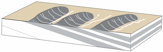
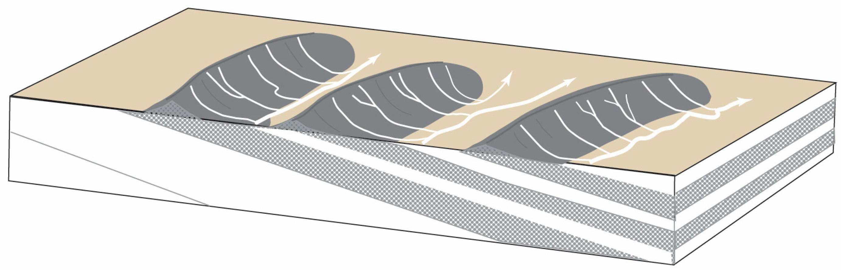
The character of stream drainage networks that develop in a region depends on the geologic and structural settings. For example, a dendritic pattern (i.e., like leaf veins) develops with a sloping land surface underlain by a spatially homogeneous geologic material. A trellis drainage network develops with structurally deformed sedimentary rocks exhibiting differences in erodibility. Figure 4 depicts an idealization of the study area with three monoclines reflecting a dipping sequence of more and less erodible rocks. More erodible rock units are associated with wadis as compared to more resistant mountainous areas, which feature an up-dip escarpment and a gentle backslope. The figure also illustrates simplified dendritic networks of paleo-stream channels cut into bedrock on the backslopes of the uplifts. During the Holocene AHP, these networks collected runoff to feed major rivers in the adjacent wadis.
Figure 4.
Dendritic stream networks on shallow-dipping backslopes of monoclines drain surface runoff into adjacent valleys. That water accumulates into one or two major rivers with the geometry of a trellis drainage system.
With a trellis drainage network, one river drains the backslope, generally following the strike of the bedrock (Figure 4). The trellis system in the study area was more complicated because formational strikes are curvilinear around the Murzuk structural basin. The advantage of a trellis drainage system with an accidental RHS is that surface runoff from numerous tributary streams on the large backslope areas would have accumulated in one and perhaps two primary rivers (Figure 4).
Rivers flowing in wadis with such a trellis drainage network provided an efficient natural transmission system. Much of the runoff from thousands of square kilometers would have ended up at one place. For example, we calculated that a storm of 75 mm (~2 inches) could produce a total volume ranging from 0.25 to 0.54 km3 of runoff in Wadi Tanezzuft, depending on the CN.
4.1.2. Garat Ouda Lake
The third major component of an RHS is a place to store runoff water until it is needed. In ancient times, cisterns were commonly used for this purpose. Isolated storage kept water clean and minimized evaporation. With Wadi Tanezzuft, serendipity came in the way of a perfectly sized, closed depression that was capable of storing a large volume of runoff, i.e., ~0.6 km3 as Garat Ouda Lake. Its location close to the source of mountain runoff was beneficial, given the possibility of losing water with a river serving to transport runoff in a desert setting. This lake storage component would be most useful if it could store water throughout the dry season. Garat Ouda Lake was a perennial water body that was sufficiently deep to accommodate evaporation losses, estimated at 1.9 m during the dry season. Even as precipitation declined toward the end of the Middle Holocene, our calculations at 5.7 ka BP found several scenarios that suggested enough runoff was available to replenish the lake through the rainy season.
Ancient societies like the Nabateans used some of their stored water to irrigate crops for food [32]. In Wadi Tanezzuft, fish, crocodiles, and hippopotami found their way into Garat Ouda Lake. They were fished and hunted to augment more typical food sources [15]. The lake could also serve to water animal herds.
Potential migration pathways for fish have been suggested [30]; but these are complicated and would have required episodic migration between watersheds with temporary connections forged by extreme flood events [30]. Remarkably, the setting here would have been available to contribute substantially to extreme flood events. For example, a rare 125 mm (~5 inches) storm in the Early Holocene could produce from 0.97 to 0.58 km3 of runoff, depending upon CNs. These contributions to human societies required a perfect storm of serendipity to create an accidental RHS.
4.1.3. Surface Water Systems in Wadi el-Agial Catchment
Away from Wadi Tanezzuft, a similar accidental RHS existed in the Wadi el-Agial catchment. Surface runoff, primarily from the Tadrart Acacus Mountains, created a 620 km long river in Wadi el-Agial with Lake Germa as the terminus [3]. Our conceptualization of the Tadrart Acacus Mountains as a source of runoff suggests a more complex system with less surface runoff from the Tadrart Acacus (i.e., smaller CNs) and more active infiltration and groundwater flow. Another major difference was the type of storage for surface water and groundwater flowing into Wadi el-Agial.
A fraction of runoff ended up stored in ponds and sand aquifers associated with the extensive dune systems of Erg Uan Kasa (Figure 1). Contributing to these small lakes would have been surface water flowing in the inter-dune corridors or groundwaters flowing through dune sand. Some of these shallow ponds contained fish [15], suggesting that water losses from dry season evaporation were buffered by groundwater inflows. The pond-shore settings were particularly attractive to pastoralists from about 7.4 to 5.0 ka BP [15].
Lake Germa, located at the base of the Messak Escarpment, provided additional storage. This lake was large [3], approximately 100 km2, and like Garat Ouda Lake, was perennial. However, unlike Garat Ouda Lake, it also received significant inflow from a groundwater flow system bringing water out of the Murzuk Basin and into Wadi el-Agial [3].
This version of an accidental RHS operated during the Early Holocene and much of the Middle Holocene. The pond systems of Erg Uan Kasa dried with the culmination of the Holocene AHP at 5.0 ka BP. Lake Germa persisted until approximately 4.0 ka [34].
4.2. Accidental Managed Aquifer Recharge
Managed aquifer recharge (MAR) is a technology that involves adding water to aquifers to combat problems of overproduction or simply to store water for later use [35]. The main difference with this approach as compared to RHSs is where and how water is stored. With MAR systems, water is stored in an aquifer using wells to pump water into the aquifer, or infiltration basins that are ponds with sandy bottoms designed to percolate water into aquifers.
Again, “accidental”, describes a natural system inherently functioning to infiltrate and to store unusually large quantities of water in the subsurface. Three essential features are necessary for successful MAR: (i) continuous flooding of an area over several months to provide the necessary water volumes, (ii) sandy surface deposits able to maintain continuous infiltration, and (iii) a vigorous flow system able to move water along a flow system to continuously create new storage in the aquifer.
Earlier sections described how sandstone massifs could yield surface water runoff with structural aspects to focus the runoff. These same elements are present with the third massif, Messak Settafet, along with serendipitous features that provided accidental MAR. Drainage from a large area of the Messak Settafet was localized at the base of the backslope (Figure 2) where it flowed slowly across large areas of sand-covered bedrock. Some of that water was held in small lakes and wetlands [3]. The more intensive storm set during the rainy season at 9.4 ka BP was calculated to produce from 0.66 to 1.6 km3 of runoff and 0.54 to 1.3 km3 at 7.3 ka BP. Most importantly, the underlying permeable aquifer featured an active flow system that moved water from the Murzuk basin toward Wadi el-Agial. However, it is expected that only a relatively small fraction of this runoff ended up stored in the subsurface. The groundwater elements of serendipity are discussed in the next section.
4.2.1. Geology and Topography
Groundwater within the Murzuk Basin is known to have flowed toward Wadi el-Agial, where it discharged to springs and lakes during the Holocene AHP and presently to saline lakes of the Ubari Sand Sea. This robust flow was able to develop due to nuances of geology and local topography. The permeable groundwater pathway exists because the Upper Member of the Messak Fm. is a 100 m thick, coarse-grained sandstone, forming the prominent escarpment [16]. The thin Middle Member consists of sandstones and mudstones. The Lower Member contains sandstone layers interbedded with layers of siltstone and mudstone and is approximately 200 m thick.
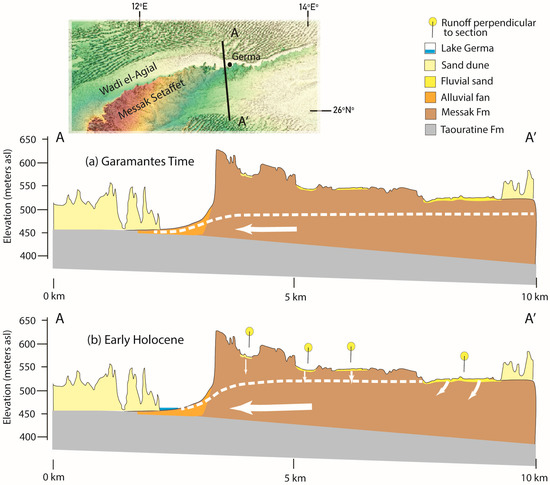
Figure 5 depicts an idealization of the hydrogeologic setting along a 10 km cross-section A-A’ that is oriented approximately normal to the Messak Escarpment (insert, Figure 5). Panel a is a representation of arid conditions during Garamantian times, approximately 2.5 ka BP, following the collapse of the Holocene AHP. Panel b represents wet conditions in the Early Holocene ~9.0 ka BP. These sections are our interpretation of published descriptions of discharge areas, flow systems, and water-table fluctuations [3,36].
Figure 5.
Idealizations of hydrogeologic settings are shown for two cross-sections through the Messak Escarpment near Germa Libya (insert). Dashed lines are the water table, and white arrows are approximate flow directions. Panel (a) represents Garamantian time, around 500 BCE. Several millennia following the end of the Holocene AHP, the water table had fallen with absence of recharge, but some flows continued into Wadi el-Agial. In the Early Holocene Panel (b), arid conditions favored active recharge, a much higher water table, and a more robust flow system.
Notice the potential for gravity-driven groundwater flow because the ground surface in the Murzuk Basin is higher than the adjacent wadis. As the white flow arrows on the cross-sections show, an active flow system exists with recharge on the Messak Escarpment and discharge into the wadi [36]. As suggested by the valley springs and inflows to lakes [3,36], the water table was highest in the system during the Early Holocene, with a robust flow system. We infer that recharge occurred at depression sites where surface water was flowing diagonally “in-and-out” of the section (see yellow lollipops, Figure 5b). This water came from surface runoff off the back slope the Messak Settafet, which flowed downhill and then laterally within Wadi Berjuj (Figure 2). Topographically, the elevation of the bottom of Wadi Berjuj is higher than Wadi el-Agial creating a gradient able to drive groundwater flow through permeable sandstone units northwestward into Wadi el-Agial. Springs that discharged into Wadi el-Agial during the Early Holocene [3,36] were evidence of these flows. Given the lack of subsurface data and measurements of hydraulic conductivity, it is not possible to calculate the quantity of groundwater discharge.
A dry climate through the Middle Holocene lowered the water table which led to a loss of springs at the base of the escarpment, at about 8 ka BP [3]. However, a diminished flow system remained active throughout Garamantian times and at present supports a few small saline lakes. The absence of hydrostratigraphic and hydrologic data precludes a quantitative description of flow systems.
4.2.2. Foggaras
One of the essential components of an MAR system is a well to recover the stored groundwater. Quite remarkably, the Garamantians in dry Sahara times began to install foggaras that in this setting functioned as low-capacity horizontal wells. There may have been hints from dug wells in Wadi el-Agial that water was available, which provided motivation to create a foggara.
Serendipity favored the Garamantians because the foggaras of Wadi el-Agial probably should not have produced water at all. The hydrologic setting of qanats in Persia (Iran), where this technology originated, was vastly different. Qanats in Persia typically tapped local unconfined alluvial-fan aquifers at the base of mountains with small volumes of stored water. Long-term sustainability depended upon yearly replenishment of the aquifer from melting snow accumulated at the top of cold high mountains each winter. Snowmelt runoff in spring would reliably end up in the aquifer and be available for use. Each year, any changes in the quantity of snow or rainfall were reflected in the quantities of water subsequently produced by the qanat [21]. The sustainable character and long lifetimes of qanats with proper maintenance (i.e., millennia) provided permanent hydraulic infrastructure and justified huge investments of human capital for their construction [37].
The foggaras along Wadi el-Agial ranged in length from 100 m to 4.5 km [38]. They were constructed as qanats in alluvium at the base of the Messak Escarpment. Modern aerial imagery of the area still shows the characteristic donut-shaped spoil piles around the former access shafts of the tunnels. These foggaras; however, differed from the typical qanats found in Iran in one important way—they were not sustainable systems. By the time foggaras were being installed by the Garamantians, rainfalls associated with the Holocene AHP were long gone, replaced by the extreme Saharan desert conditions of the Late Holocene (Figure 5b). In other words, water discharged from foggaras was not being replaced by recharge every year. Although stored groundwater from the Holocene AHP remained with the accidental MAR system, lowering of the water table starved the foggara systems of water. This failure of the technology occurred because qanats or foggaras work by skimming groundwater at the top of the water table. Production of groundwater by foggaras began approximately 300 BCE and by the fourth-century CE the water ran out [7].
Ultimately, the temporary success of this Garamantian groundwater venture was their good fortune in tapping into the side of a prolific aquifer. The Messak Formation is a highly productive, regional aquifer that is a direct geologic and hydrologic relative [39] of the iconic Nubian Sandstone Aquifer System.
5. Conclusions
This paper shows how ancient societies rose and fell due to constraints of the physical setting, particularly those contributing to the availability of water. Within extremely arid environments, it is unreasonable to expect sustainable settings to exist broadly across landscapes. Of course, this statement is well understood with unique examples provided by oases in Egypt’s Western Desert or the lands along the Nile River. What is different in our study area is that societies succeeded locally with water and some food requirements provided by a complicated natural system defined by an array of novel climatologic, geologic and hydrologic features/events. Given the complexity of interacting systems, their usefulness in magnifying the local availability of water was unique.
From a climatological perspective, the Holocene AHP ended in our study area about 5 ka BP. However, from a hydrogeologic perspective, the impacts of the Holocene AHP and even earlier ones lingered through Garamantian times and even up to the present day with the stored groundwater. Our analyses suggest that the Garamantes did not run out of groundwater per se but ran out of technology to tap the large groundwater resources in the Murzuk Basin. We know this because today, farmers in the Murzuk Basin are pumping fresh water from the Messak Fm. to irrigate crops in the desert [40]. Amazingly, even after a long hiatus from the previous AHP, the early millennia of the Holocene AHP saw groundwater in the Murzuk Basin topped up with evidence of a significantly more active flow system into Wadi el-Agial. Serendipity in the novel structural and hydrologic settings of the Murzuk Basin limited the wholesale drainage of groundwater from the basin during the long intervals between AHPs.
Supplementary Materials
The following supporting information can be downloaded at: https://www.mdpi.com/article/10.3390/hydrology13080207/s1, Table S1: Summary of data used in runoff calculations and calculated runoff for scenarios.
Author Contributions
Conceptualization, F.S.; methodology, F.S. and G.L.; software, G.L.; validation, F.S.; data curation, G.L.; writing—original draft preparation, F.S.; writing—review and editing, F.S. and G.L.; visualization, G.L.; supervision, F.S.; project administration, F.S. All authors have read and agreed to the published version of the manuscript.
Funding
This research received no external funding.
Data Availability Statement
The Shuttle Radar Topography Mission (SRTM) 3 Arc-Second Global elevation data used to prepare the DEM maps in Figure 1 and Figure 2. The data, SRTM 90 m DEM Version 4 [22], was accessed and downloaded at https://srtm.csi.cgiar.org (URL accessed on 13 June 2026). (All spatial analysis and map generation were conducted using ArcGIS Pro [v3.4], a proprietary GIS software developed by Esri https://www.esri.com/en-us/arcgis/products/arcgis-pro/overview (URL accessed on 13 June 2026).
Conflicts of Interest
The authors declare no conflicts of interest.
Abbreviations
The following abbreviations are used in this manuscript:
| AHP | African Humid Period |
| asl | above sea level |
| BCE | Before Common Era |
| ka BP | thousand years before present |
| CE | Common Era |
| CN | Curve Number |
| DEM | Digital Elevation Model |
| MAR | managed aquifer recharge |
| RHS | Rainfall Harvesting System |
| SCS | Soil Conservation Service |
| SRTM | Shuttle Radar Topography Mission |
References
- Clark, G. Water in antiquity. Antiquity 1944, 18, 1–15. [Google Scholar] [CrossRef] [Scilit]
- Larrasoana, J.C.; Roberts, A.P.; Rohling, E.J. Dynamics of the North African monsoon and the African Humid Period. PLoS ONE 2013, 8, e56571. [Google Scholar] [CrossRef] [Scilit]
- Drake, N.A.; Lem, R.E.; Armitage, S.J.; Breeze, P.; Francke, J.; El-Hawat, A.S.; Salem, M.J.; Hounslow, M.W.; White, K. Reconstructing palaeoclimate and hydrological fluctuations in the Fezzan Basin (southern Libya) since 130 ka: A catchment-based approach. Quat. Sci. Rev. 2018, 200, 376–394. [Google Scholar] [CrossRef] [Scilit]
- Cheddadi, R.; Carré, M.; Nourelbait, M.; François, L.; Rhoujjati, A.; Manay, R.; Ochoa, D.; Schefuß, E. Early Holocene greening of the Sahara requires Mediterranean winter rainfall. Proc. Natl. Acad. Sci. USA 2021, 118, e2024898118. [Google Scholar] [CrossRef] [Scilit] [PubMed]
- Cremaschi, M.; Zerboni, A.; Spötl, C.; Felletti, F. The calcareous tufa in the Tadrart Acacus Mt. (SW Fezzan, Libya): An early Holocene palaeoclimate archive in the central Sahara. Palaeogeogr. Palaeoclimatol. Palaeoecol. 2010, 287, 81–94. [Google Scholar] [CrossRef] [Scilit]
- Cremaschi, M. Holocene climatic changes in an archaeological landscape: The case study of Wadi Tanezzuft and its drainage basin (SW Fezzan, Libyan Sahara). Libyan Stud. 2001, 32, 3–27. [Google Scholar] [CrossRef] [Scilit]
- Keys, D. Kingdom of the Sands. Archaeology 2004, 57, 24–29. [Google Scholar]
- Wilson, A. Foggara irrigation, early state formation and Saharan trade: The Garamantes of Fezzan. Schriftenreihe Front.-Ges. 2005, 26, 223–234. [Google Scholar]
- Pausata, F.S.; Gaetani, M.; Messori, G.; Berg, A.; de Souza, D.M.; Sage, R.F.; DeMenocal, P.B. The greening of the Sahara: Past changes and future implications. One Earth 2020, 2, 235–250. [Google Scholar] [CrossRef] [Scilit]
- Larrasoaña, J.C. A review of West African monsoon penetration during Green Sahara periods; implications for human evolution and dispersals over the last three million years. Oxf. Open Clim. Change 2021, 1, kgab011. [Google Scholar] [CrossRef] [Scilit]
- Perego, A.; Cremaschi, M.; Zerboni, A. Geomorphic map of Messak Settafet using Landsat and SRTM data. J. Maps 2011, 7, 464–475. [Google Scholar] [CrossRef] [Scilit]
- Zerboni, A.; Perego, A.; Cremaschi, M. Geomorphological map of the Tadrart Acacus massif and the Erg Uan Kasa (Libyan central Sahara). J. Maps 2015, 11, 772–787. [Google Scholar] [CrossRef] [Scilit]
- Coulson, D.; Campbell, A. Rock art of the Tassili n’Ajjer, Algeria. Adoranten 2010, 1, 24–38. [Google Scholar]
- Biagetti, S. Ethnoarchaeology of the Kel Tadrart Tuareg: Pastoralism and Resilience in Central Sahara; Springer: Cham, Switzerland, 2014; pp. 1–164. [Google Scholar] [CrossRef] [Scilit]
- Cremaschi, M.; Zerboni, A. Early to Middle Holocene landscape exploitation in a drying environment: Two case studies compared from the central Sahara (SW Fezzan, Libya). Comptes Rendus Geosci. 2009, 341, 689–702. [Google Scholar] [CrossRef] [Scilit]
- Wood, J.D.; Bodin, S.; Redfern, J.; Thomas, M.F.H. Controls on facies evolution in low accommodation, continental-scale fluvio-paralic systems (Messak Formation, SW Libya). Sediment. Geol. 2014, 303, 49–69. [Google Scholar] [CrossRef] [Scilit]
- Cremaschi, M.; Zerboni, A. Human communities in a drying landscape: Holocene climate change and cultural response in the central Sahara. In Landscapes and Societies: Selected Cases; Springer: Dordrecht, The Netherlands, 2010; pp. 67–89. [Google Scholar]
- Cremaschi, M. Late Quaternary geological evidence for environmental changes in south-western Fezzan (Libyan Sahara). In Wadi Teshuinat: Palaeoenvironment and Prehistory in South-Western Fezzan (Libyan Sahara); Cremaschi, M., di Lernia, S., Eds.; Quaderni di Geodinamica Alpina e Quaternaria 7; Edizioni All’Insegna del Giglio: Milano, Italy, 1998; pp. 13–48. [Google Scholar]
- Di Lernia, S.; N’Siala, I.M.; Mercuri, A.M.; Zerboni, A. Land-use and cultivation in the etaghas of the Tadrart Acacus (south-west Libya): The dawn of Saharan agriculture? Antiquity 2020, 94, 580–600. [Google Scholar] [CrossRef] [Scilit]
- Cremaschi, M.; Di Lernia, S. Environment and settlements in the Mid-Holocene palaeo-oasis of Wadi Tanezzuft (Libyan Sahara). Antiquity 2001, 75, 815–825. [Google Scholar] [CrossRef] [Scilit]
- Beaumont, P. Qanat systems in Iran. Bull. Int. Assoc. Sci. Hydrol. 1971, 16, 39–50. [Google Scholar] [CrossRef] [Scilit]
- Jarvis, A.; Reuter, H.I.; Nelson, A.; Guevara, E. Hole-Filled Seamless SRTM Data V4. International Centre for Tropical Agriculture (CIAT). Available online: https://srtm.csi.cgiar.org (accessed on 13 June 2026).
- Esri. ArcGIS Pro (Version 3.x). Computer Software. Available online: https://www.esri.com/en-us/arcgis/products/arcgis-pro/overview (accessed on 13 June 2026).
- Soil Conservation Service. National Engineering Handbook: Section 4—Hydrology; USDA: Washington, DC, USA, 1972. [Google Scholar]
- Mishra, S.K.; Pandey, A.; Singh, V.P. Special issue on soil conservation service curve number (SCS-CN) methodology. J. Hydrol. Eng. 2012, 17, 1157. [Google Scholar] [CrossRef] [Scilit]
- Awadallah, A.G.; Saad, H.; Elmoustafa, A.; Hassan, A. Reliability assessment of water structures subject to data scarcity using the SCS-CN model. Hydrol. Sci. J. 2016, 61, 696–710. [Google Scholar] [CrossRef] [Scilit]
- Wikimedia Commons. Tassili n’Ajjer Map. Available online: https://commons.wikimedia.org (accessed on 13 June 2026).
- Salack, S.; Sarr, B.; Bliefernicht, J.; Kunstmann, H. Scales for rating heavy rainfall events in the West African Sahel. Weather Clim. Extrem. 2018, 21, 36–42. [Google Scholar] [CrossRef] [Scilit]
- Tasker, G.D.; Stedinger, J.R. Regional skew with weighted Bayesian regression. Water Resour. Res. 1986, 22, 225–237. [Google Scholar] [CrossRef] [Scilit]
- Van Neer, W.; Alhaique, F.; Wouters, W.; Dierickx, K.; di Lernia, S. Aquatic fauna from the Takarkori rock shelter. PLoS ONE 2020, 15, e0228588. [Google Scholar] [CrossRef] [Scilit] [PubMed]
- de Fleury, M.; Kergoat, L.; Grippa, M. Hydrological regime of Sahelian small waterbodies from combined Sentinel-2 MSI and Sentinel-3 Synthetic Aperture Radar Altimeter data. Hydrol. Earth Syst. Sci. 2023, 27, 2189–2204. [Google Scholar] [CrossRef] [Scilit]
- AbdelKhaleq, R.A.; Alhaj Ahmed, I. Rainwater harvesting in ancient civilizations in Jordan. Water Sci. Technol. Water Supply 2007, 7, 85–93. [Google Scholar] [CrossRef] [Scilit]
- Ghimire, S.R.; Johnston, J.M.; Ingwersen, W.W.; Hawkins, T.R. Life cycle assessment of domestic and agricultural rainwater harvesting systems. Environ. Sci. Technol. 2014, 48, 4069–4077. [Google Scholar] [CrossRef] [Scilit] [PubMed]
- Brooks, N.; Drake, N.; McLaren, S.; White, K. Studies in geography, geomorphology, environment and climate. In The Archaeology of Fazzan; Synthesis; The Society for Libyan Studies/Tripoli the Department of Antiquities: London, UK, 2003; Volume 1, pp. 37–74. [Google Scholar]
- Schwartz, F.W.; Zhang, H. Fundamentals of Hydrology; Wiley: Hoboken, NJ, USA, 2024. [Google Scholar]
- Drake, N.; Wilson, A.; Peiling, R.; White, K.; Mattingly, D.; Black, S. Water table decline, springline desiccation and the early development of irrigated agriculture in the Wādi al-Ajāl, Libyan Fazzān. Libyan Stud. 2004, 35, 95–112. [Google Scholar] [CrossRef] [Scilit]
- Wulff, H.E. The qanats of Iran. Sci. Am. 1968, 218, 94–105. [Google Scholar] [CrossRef] [Scilit]
- Wilson, A.I.; Mattingly, D.J. Irrigation technologies: Foggaras, wells and field systems. In The Archaeology of Fezzan; Mattingly, D.J., Ed.; Society for Libyan Studies: London, UK, 2003; Volume 1, pp. 235–278. [Google Scholar]
- Lorenz, J.C. Mixed fluvial systems of the Messak Sandstone, a deposit of the Nubian lithofacies, southwestern Libya. Sedim. Geol. 1987, 54, 245–274. [Google Scholar] [CrossRef] [Scilit]
- Shaki, A.A.; Adeloye, A.J. Evaluation of quantity and quality of irrigation water at Gadowa irrigation project in Murzuk basin, southwest Libya. Agric. Water Manag. 2006, 84, 193–201. [Google Scholar] [CrossRef] [Scilit]

Disclaimer/Publisher’s Note: The statements, opinions and data contained in all publications are solely those of the individual author(s) and contributor(s) and not of MDPI and/or the editor(s). MDPI and/or the editor(s) disclaim responsibility for any injury to people or property resulting from any ideas, methods, instructions or products referred to in the content. |
© 2026 by the authors. Licensee MDPI, Basel, Switzerland. This article is an open access article distributed under the terms and conditions of the Creative Commons Attribution (CC BY) license.