


Abstract
Subgrades are vulnerable to hydrological effects, repeated loading, and material degradation, which may induce settlement, voids, loosening, and differential deformation and ultimately threaten the safety and serviceability of transportation infrastructure. With the growing demand for continuous and intelligent condition assessment, conventional single modality inspection methods are increasingly insufficient for complex field environments. This paper reviews recent advances in intelligent subgrade inspection and distress identification following a “sensing–identification–application” framework. Multi-physics sensing technologies, including ground-penetrating radar, elastic-wave testing, intelligent compaction, and embedded sensing, are summarized with emphasis on their applicable distress types, sensing characteristics, and life-cycle stages. AI-based methods for distress identification and condition prediction are then discussed, covering image recognition, object detection, semantic segmentation, time-series forecasting, and physics-informed data fusion. Engineering applications involving vehicle, rail, UAV, and robot-based inspection platforms are also examined. Future research should focus on multisource sensing fusion, stronger integration of data-driven models with engineering mechanics, improved cross-scenario adaptability, and closer links between inspection results and maintenance decisions. These advances are expected to support a transition from passive distress detection toward proactive prediction and intelligent infrastructure management.
1. Introduction
Subgrade engineering forms the principal load-bearing foundation of railway and highway infrastructure, and its service condition directly affects traffic safety, service life, and maintenance cost. With the operating mileage of high-speed railways in China exceeding 45,000 km and that of expressways exceeding 180,000 km, ensuring the long term performance of subgrade structures has become a central issue in transportation infrastructure operation and maintenance [1].
In recent years, extensive research has addressed subgrade condition inspection and distress identification using GPR, elastic-wave testing, intelligent compaction, fiber-optic sensing, machine learning, and deep learning [2,3,4]. Existing reviews have generally focused on individual inspection techniques, sensing and monitoring methods, or intelligent identification of subsurface distresses, providing important references for technological development [5,6]. However, a unified framework is still lacking for systematically explaining the complementarity among sensing modalities, the linkage between intelligent identification algorithms and engineering inspection platforms, and the complete technical chain through which inspection results are ultimately translated into maintenance decisions.
The contribution of this review lies not merely in bringing together different sensing technologies and intelligent algorithms, but in establishing an integrated analytical perspective on their relationships and engineering applicability. Specifically, this review links characteristic subgrade distresses and their physical responses to sensing modalities, data characteristics, and suitable intelligent analysis tasks. It further examines how these methods correspond to different inspection platforms and operational requirements, while critically assessing their limitations in field validation, cross-scenario generalization, computational efficiency, and engineering implementation. By connecting these aspects within a unified “sensing–identification–application” framework, this review aims to clarify not only what technologies are available, but also why particular combinations may be suitable for specific inspection tasks, under what conditions their performance may be limited, and what remains necessary for reliable engineering deployment.
Accordingly, this review examines intelligent subgrade inspection through an integrated “sensing–identification–application” framework. It first analyzes typical subgrade distresses and their physical characteristics to establish the inspection requirements associated with different distress mechanisms. It then reviews multi-physics sensing technologies, including ground-penetrating radar (GPR), elastic-wave testing, intelligent compaction, and embedded sensing, with emphasis on the physical information they provide and their respective limitations. Subsequently, deep-learning-based identification and prediction methods are examined in relation to their input data, analytical tasks, and engineering applicability. The review further investigates the integration of these methods with vehicle-mounted, rail-mounted, UAV-based, and robotic inspection platforms, considering field validation, environmental adaptability, model generalization, computational efficiency, economic feasibility, and relevant technical standards. Finally, it synthesizes the remaining challenges and research opportunities in multimodal sensing fusion, physics-informed intelligence, and the transition from distress identification to engineering assessment and maintenance decision-making, as illustrated in Figure 1.
Figure 1.
Intelligent subgrade inspection: from data sensing and distress identification to engineering applications (created by author).
This study adopts a narrative and critical review approach to examine advances in intelligent inspection and distress identification for transportation subgrades. Relevant publications were identified through Web of Science, Google Scholar, ScienceDirect, and SpringerLink. The literature search focused on combinations of keywords related to transportation subgrades, subgrade distress, ground-penetrating radar (GPR), elastic-wave testing, intelligent compaction, fiber-optic sensing, deep learning, distress identification, condition prediction, and automated inspection. In addition, relevant references cited in the identified publications were examined to identify representative studies related to the review objectives.
Selection of the literature was guided primarily by the relevance of each study to subgrade distress mechanisms, sensing technologies, intelligent identification and prediction methods, or engineering inspection applications. Particular attention was given to studies providing clear descriptions of their methods, experimental conditions, evaluation results, or practical implementation. Research concerning closely related pavement and railway-track structures was also considered where its findings offered relevant methodological or engineering insights for subgrade inspection. Publications with limited relevance to the review scope or insufficient technical information were not prioritized.
The selected literature was organized and critically analyzed using a thematic and comparative approach. The assessment considered the physical characteristics of the target distresses, sensing mechanisms and limitations, data requirements, intelligent analysis tasks, reported performance, field-validation evidence, environmental adaptability, computational efficiency, and engineering deployment constraints. These analytical dimensions were used to establish relationships among distress characteristics, sensing methods, intelligent algorithms, and inspection platforms within the proposed “sensing–identification–application” framework. Given the considerable differences in inspection targets, datasets, and evaluation protocols across studies, reported performance indicators were interpreted in their respective experimental contexts rather than combined into a unified quantitative ranking.
2. Subgrade Distress Characteristics and Requirements for Intelligent Inspection
During construction and long-term service, subgrades are jointly affected by geological conditions, hydrological environments, construction quality, and traffic loading, and may develop differential settlement, debonding and voids, mud pumping, abnormal moisture, weak interlayers, and nonuniform compaction. Their mechanisms and spatial scales differ. Differential settlement is mainly associated with variations in foundation compressibility, heterogeneity of fill materials, and long-term loading; debonding, mud pumping, and moisture anomalies are closely related to groundwater migration, loss of fine particles, and coupled dynamic loading; and inadequate or nonuniform compaction during construction produces spatially heterogeneous stiffness that may evolve into vulnerable zones of settlement and deformation during service [7,8,9]. Despite different causes, these distresses ultimately manifest as anomalies in dielectric properties, wave velocity and stiffness, strain, and settlement, providing the physical basis for multi-physics inspection [3,6] (Figure 2).
Figure 2.
Typical subgrade distresses, physical responses, and inspection technologies (created by author).
To ensure terminological consistency, several related terms are distinguished in this review. “Distress” is used as the overarching term for adverse conditions and deterioration affecting subgrade performance, including differential settlement, voids, mud pumping, and localized weakening. “Defect” refers more specifically to identifiable imperfections in materials, construction, or structural components. “Anomaly” denotes an abnormal response or deviation detected in inspection data, such as unusual electromagnetic reflections, wave velocities, or strain measurements, which does not necessarily indicate confirmed distress. Accordingly, “distress” is consistently used when referring to subgrade deterioration, whereas “anomaly” and “defect” are retained only where their specific meanings are intended.
Compared with visible pavement distresses, subgrade distresses are more concealed, progressive, and environmentally sensitive. Most occur beneath the pavement or ballast, or within structural layers, and cannot be directly detected by visual inspection. Inspection technologies therefore require sufficient penetration and the ability to characterize structural and material changes at different depths. Moreover, settlement, moisture variation, and the development of weak zones often evolve over long periods, making single-epoch inspection insufficient for reliable trend assessment; long-term continuous monitoring is required to obtain temporal information. Soil dielectric constants, elastic parameters, and sensor responses are also affected by temperature, moisture, traffic-induced vibration, and construction conditions, causing distress signatures to overlap with environmental disturbances. Intelligent subgrade inspection must therefore combine adequate spatial coverage and resolution with continuous monitoring, quantitative assessment, and robust recognition under complex environmental conditions [2].
These requirements have driven subgrade inspection from experience-based manual interpretation toward instrumentation, automation, and intelligence. Early condition assessment relied mainly on visual surveys, borehole sampling, settlement observations, and point-based mechanical tests. Although these methods provide direct engineering information, they are inefficient, spatially sparse, and strongly influenced by operator experience. The development of GPR, surface-wave testing, falling-weight deflectometry, intelligent compaction, and embedded sensing has progressively enabled mechanized, continuous, and standardized data acquisition, making large-scale nondestructive inspection and long-term monitoring feasible. Nevertheless, large volumes of inspection data at this stage were still interpreted manually or through empirical rules, limiting efficiency and consistency for large infrastructure networks. More recently, machine-learning and deep-learning methods have been introduced for radar images, vibration signals, and settlement and compaction time series, shifting analysis from handcrafted features toward data-driven automatic identification and condition prediction. Consequently, subgrade inspection is evolving from simple “data acquisition” toward integrated “sensing–identification–assessment” [10].
Overall, the multiscale and multi-physics response characteristics of subgrade distresses mean that no single inspection method can cover all distress types and life-cycle stages. Because existing techniques differ markedly in detection depth, spatial resolution, continuous-monitoring capability, and environmental adaptability, they should be analyzed within a multi-physics framework and coordinated with intelligent identification methods.
3. Multi-Physics Sensing Technologies for Subgrade Distresses
Subgrade distresses are generally accompanied by changes in dielectric properties, wave velocity and stiffness, strain, and deformation, and different inspection techniques exhibit different sensitivities to these physical responses. Current sensing approaches mainly include electromagnetic inspection represented by GPR, elastic-wave inspection represented by surface-wave testing, intelligent compaction for construction-stage quality control, and embedded sensing for long-term service monitoring [2]. These methods differ in detection depth, spatial resolution, continuous-monitoring capability, and applicable stage, and their complementary use forms the basis of life-cycle subgrade condition sensing.
3.1. Electromagnetic-Field Sensing: Ground-Penetrating Radar
GPR nondestructively investigates subsurface structure and material condition by transmitting high-frequency electromagnetic waves into the subgrade and receiving reflections and scattering from interfaces between different media; see Figure 3. Its performance is primarily controlled by antenna center frequency and by the dielectric constant, electrical conductivity, and moisture condition of the medium [5,11,12]. Lower frequencies generally provide greater penetration but lower spatial resolution, whereas higher frequencies improve sensitivity to shallow anomalies but attenuate more rapidly [13]; see Figure 4. Antenna frequency should therefore be selected according to the burial depth and scale of the target distress and the properties of the subgrade material.
Figure 3.
A subgrade condition inspection vehicle equipped with a three-channel GPR antenna array (reproduced from reference [14], licensed under CC BY 4.0).
Figure 4.
GPR images obtained with 400 and 900 MHz antennas and the corresponding layer interfaces: (a) 400 Hz GPR image; (b) track bed layer identification by 400 Mhz GPR; (c) 900 Hz GPR image; (d) track bed layer identification by 900 Mhz GPR (reproduced from reference [13], licensed under CC BY 4.0).
GPR data are commonly represented as A-scans, B-scans, and three-dimensional data volumes [15]. An A-scan records the time-varying echo at a single measurement point; sequential A-scans form a B-scan profile that reflects longitudinal structural variations. Transverse information obtained from multiple survey lines or multichannel arrays can be assembled into a three-dimensional radar volume. Compared with a single two-dimensional profile, 3D GPR preserves more complete spatial information on subsurface structures and can improve the localization of cavities, debonding, and other subsurface targets [16,17].
Different distresses affect GPR signals through different mechanisms [18]. Debonding and cavities produce abrupt contrasts in electromagnetic properties and therefore pronounced reflection anomalies. Increased moisture changes soil dielectric constant and electrical conductivity and affects propagation velocity, reflection characteristics, and signal attenuation. Mud pumping commonly involves both moisture variation and migration of fine particles, producing the spatially heterogeneous radar responses shown in Figure 5. For compaction assessment, dielectric response is influenced not only by density but also by moisture content and fill type; quantitative compaction evaluation based on a single radar feature is therefore limited. Yan et al. analyzed the relationship between subgrade dielectric constant and moisture content through laboratory and field tests under different compaction levels, further demonstrating the coupled influence of moisture and compaction on GPR response [19].
Figure 5.
Representative GPR images of subgrade distresses: (a) normal subgrade; (b) settlement; (c) sinkhole; (d) mud pumping (reproduced from reference [18], licensed under CC BY 4.0).
Overall, GPR offers high inspection speed, relatively high spatial resolution, and suitability for continuous large-area surveys, particularly for shallow interfaces, debonding, cavities, and moisture anomalies. Interpretation is nevertheless affected by moisture, soil type, electrical conductivity, and the field electromagnetic environment, and an inherent trade-off exists between penetration depth and resolution. GPR is therefore particularly suitable for the rapid screening of internal structural anomalies, while the characterization of anomaly type and mechanical condition generally requires complementary methods [20].
The transition from synthetic GPR datasets to real-world measurements introduces additional uncertainty when assessing the reliability of subsurface distress identification methods. Xue et al. [21] reported an mAP of 96.4% on synthetic GPR data and 91.9% on real GPR data, indicating a 4.5-percentage-point difference between the two evaluation settings. Although this finding highlights the importance of validation using real measurements, the performance difference cannot be attributed solely to environmental noise because the datasets may differ in their characteristics and evaluation conditions. Furthermore, synthetic and real data comparisons should not be interpreted as direct laboratory-versus-field comparisons. These considerations highlight the need for reliable ground-truth verification and transparent field evaluation protocols when assessing the practical applicability of GPR-based inspection.
3.2. Elastic-Wave-Field Sensing: Surface/Rayleigh Waves
Elastic-wave testing infers the mechanical condition of soil from wave-propagation characteristics. Common surface-wave methods include spectral analysis of surface waves (SASW) and multichannel analysis of surface waves (MASW), both of which exploit Rayleigh-wave dispersion in layered media to obtain the variation in shear-wave velocity with depth [22]. Because shear-wave velocity is closely related to soil stiffness, surface-wave methods can characterize stiffness contrasts, weak interlayers, and compaction condition from a mechanical perspective [23,24].
In layered subgrades, different frequency components correspond to different effective investigation depths: high-frequency components primarily reflect shallow materials, whereas lower frequencies penetrate deeper [25]. Extraction and inversion of dispersion curves yield shear-wave-velocity profiles that can be used to assess stiffness variations with depth. Unlike GPR, which is primarily sensitive to dielectric anomalies, surface-wave methods reflect mechanical properties and are therefore promising for identifying weak layers, stiffness degradation, and compaction condition.
Conventional surface-wave testing generally requires the artificial excitation and deployment of geophones, which limits efficiency and spatial coverage. In railway environments, persistent train-induced vibration may also interfere with the extraction of the effective wavefield [26]. Field blind tests on high-speed railways by Kyrkou et al. showed that useful dispersion information can still be obtained when appropriate time windows and signal-processing procedures are adopted, although ambient noise reduces the signal-to-noise ratio and inversion stability [23].
Surface-wave inspection is increasingly moving toward noncontact acquisition, continuous sensing, and automated evaluation. Wang et al. proposed an air-coupled surface-wave method for assessing subgrade compaction quality, using acoustic-pressure sensors to acquire surface-wave signals without contact and combining deep-learning and machine-learning models for compaction-state identification and degree-of-compaction prediction. Validation across multiple construction scenarios demonstrated the feasibility of continuous nondestructive inspection, indicating a transition from traditional point testing toward large-scale continuous elastic-wave sensing [27].
The spatial resolution of surface-wave methods is constrained by effective wavelength and sensor configuration, and localized defects much smaller than the effective wavelength generally produce weak anomalies. Surface-wave testing is therefore better suited to evaluating overall stiffness and weak zones over a finite spatial range. Small cavities and localized debonding are more effectively assessed by combining surface waves with higher-resolution GPR.
3.3. Continuous Construction-Stage Sensing: Intelligent Compaction
Intelligent compaction uses accelerometers, positioning devices, and operating-parameter sensors mounted on vibratory rollers to capture the dynamic response of the roller–soil interaction in real time and thereby evaluate compaction quality and spatial uniformity [28]; see Figure 6. Compared with conventional point-based spot checks such as sand-cone or core-cutter tests, intelligent compaction continuously records roller trajectories and compaction responses, increasing coverage while providing a data basis for real-time feedback and adaptive construction control [10].
Figure 6.
Modification of compaction equipment (reproduced from reference [28], licensed under CC BY 4.0).
The core of intelligent compaction assessment is the construction of intelligent compaction measurement values (ICMVs) from vibration responses. Common indices include the compaction meter value (CMV), continuous compaction control value (CCV), and indicators derived from roller dynamics and energy response. Wang et al. combined CMV, roller passes, moisture content, and other parameters with an artificial neural network to predict subgrade compaction quality in real time [29]. Zhu et al. further developed an improved compaction-stiffness indicator from coupled roller–soil dynamics, providing a means of accounting for nonlinear dynamic behavior [30]. ICMVs, however, are not direct measurements of degree of compaction or modulus. They are simultaneously affected by fill type, moisture condition, lift thickness, underlying-layer stiffness, vibration frequency and amplitude, and roller speed [31,32,33]. Consequently, the relationship between a given ICMV and conventional compaction indices may vary among projects, soils, and construction conditions, limiting model transferability. A systematic review by Zhu et al. also identified persistent limitations in the accuracy, stability, and operating-condition applicability of current ICMVs [34].
Accordingly, intelligent compaction research is shifting from the development of new isolated indices toward multisource construction-parameter fusion, scenario-adaptive evaluation, and real-time quality prediction using data-driven models [29,35]. From a life-cycle perspective, its principal advantage lies in the construction stage, where it enables a transition from “point sampling” to “continuous sensing–real-time evaluation–construction feedback.” Internal service-stage distresses and long-term deformation still require complementary monitoring techniques.
3.4. In Situ Service-Stage Monitoring: Fiber-Optic Sensing
Unlike periodic inspection methods such as GPR and surface-wave testing, embedded sensing can continuously acquire strain, temperature, settlement, and dynamic responses during long-term service, providing time-series data for distress evolution and performance assessment [36]. Fiber-optic sensing is particularly attractive because of its immunity to electromagnetic interference, long-distance deployment capability, and suitability for distributed or quasi-distributed measurements, and has received substantial attention in long-term railway and highway monitoring [37,38].
According to sensing principle and spatial sampling mode, commonly used fiber-optic technologies include fiber Bragg gratings (FBGs) and distributed fiber-optic sensing. FBGs detect local strain and temperature through shifts in the Bragg wavelength and can be multiplexed along a fiber to form a quasi-distributed monitoring network [39,40]. The practical application of FBG sensing in subgrade monitoring is illustrated in Figure 7, which shows the field deployment of vertically installed FBG sensors and the associated power supply and data acquisition system for monitoring subgrade deformation [41].
Figure 7.
VI-FBG sensor installation: (a) a schematic diagram of the on-site sensor layout at the bottom of the subgrade bed, and (b) the on-site layout of the solar power supply and data acquisition system. (Reproduced from reference [41], licensed under CC BY 4.0).
Distributed fiber-optic sensing obtains continuous spatial information from scattering along the fiber. Brillouin-scattering-based BOTDR/BOTDA systems can measure strain and temperature over long distances and are suitable for monitoring subgrade settlement and differential deformation. Zhang et al. used distributed Brillouin sensing to obtain strain distributions along a subgrade and invert settlement profiles, with good agreement with conventional settlement measurements [42]. Distributed fiber sensing has also been applied to continuous strain-field monitoring under localized deformation such as fault displacement, demonstrating its potential for capturing spatially nonuniform subgrade deformation [43,44].
The principal advantage of fiber-optic monitoring is its ability to provide long-term, continuous, and quantitative service-condition information. Engineering application is nevertheless constrained by installation requirements and long-term sensor reliability. Embedded fibers generally need to be installed during construction, making the retrofit of existing lines difficult. Long-term operation must also address temperature cross-sensitivity, construction damage, interface coupling, material aging, and data drift. Fiber-optic sensing is therefore better suited to long-term in situ monitoring of critical sections and structures than to replacing large-area inspection technologies.
Overall, subgrade sensing has evolved from isolated inspection techniques toward coordinated multi-physics sensing systems (Table 1). GPR, elastic waves, intelligent compaction, and in situ monitoring provide complementary information on structural anomalies, mechanical condition, construction quality, and long-term evolution, respectively shown in Figure 8. Future sensing systems should not seek to replace all methods with a single technology; instead, they should strengthen information complementarity and coordinated fusion among sensing modalities to improve reliable condition identification under complex distress scenarios and provide a more complete data basis for intelligent analysis and engineering decision-making.
Table 1.
Comparison of four representative subgrade inspection methods.
Figure 8.
The complementarity of multi-physics sensing technologies across the subgrade life cycle (created by author).
The selection of sensing technologies and intelligent identification methods should be guided by the physical responses of specific subgrade distresses. For example, voids and debonding generally produce localized dielectric contrasts that can be captured by GPR and subsequently analyzed using image-based detection or segmentation models. In contrast, weak interlayers and nonuniform compaction are more directly associated with variations in stiffness and dynamic response, making elastic-wave measurements and intelligent compaction data more suitable for mechanical condition assessment. Differential settlement is characterized by progressive deformation and is therefore better investigated using continuous strain and displacement monitoring combined with time-series prediction models. These relationships indicate that the sensing modality determines the available physical information, while the data characteristics and required engineering outputs influence the selection of intelligent analysis methods. Accordingly, the following section examines intelligent identification and prediction approaches in relation to their sensing data and intended engineering tasks.
4. Intelligent Distress Identification and Condition Prediction
As subgrade inspection shifts from point testing to continuous sensing and multisource monitoring, the volumes of GPR images, vibration signals, compaction parameters, and settlement time series have increased rapidly. Conventional analysis based on manual experience or predefined features is increasingly inadequate for large-scale inspection. Machine learning and deep learning can automatically extract distress-related features from complex data, enabling a transition from manual interpretation toward automated identification and predictive assessment. Current studies mainly address two task classes: identifying the type and spatial location of subsurface distresses from GPR images or waveforms, and predicting compaction quality and settlement deformation from construction and long-term monitoring time series. Meanwhile, limited labeled samples, distribution shifts among engineering scenarios, and insufficient physical interpretability of purely data-driven models have stimulated research on few-shot learning, transfer learning, and physics-informed fusion [2,4].
4.1. Intelligent Distress Identification from GPR Data
GPR is among the most widely used data sources for intelligent identification of subsurface subgrade distresses. Distress information can be extracted from single-trace A-scans, two-dimensional B-scan profiles, and three-dimensional radar volumes. Traditional methods rely on handcrafted features such as amplitude, phase, spectrum, and hyperbolic signatures, whereas deep learning can learn hierarchical representations directly from raw or preprocessed radar data and offers stronger feature representation in complex backgrounds [45]. GPR interpretation has consequently progressed from rule-based and conventional machine-learning approaches toward deep-learning methods represented by convolutional neural networks, object detection, and semantic segmentation [4,46].
According to the task objective, existing methods can be broadly classified into image classification, object detection, and semantic segmentation [47]. Classification models determine whether a radar image or data segment contains a distress and, if so, its category, making them suitable for rapid screening of large datasets. Li et al. used deep learning to identify subsurface distresses in GPR data and improved automated analysis of complex radar images compared with methods based on handcrafted features [48]. Xu et al. further investigated intelligent recognition in subgrade B-scans, demonstrating the applicability of deep learning to subsurface distress detection in transportation infrastructure [49].
Compared with classification alone, object-detection models simultaneously output distress category and spatial location, more closely matching the engineering workflow of “detect an anomaly–locate the anomaly.” One-stage detectors such as YOLO have therefore been increasingly applied to GPR distress detection because of their relatively high inference speed [21,50]. To address limited labeled samples, Elseicy et al. combined generative few-shot data augmentation with YOLOv11 for detecting cavities and loosened zones; expanding the training set improved detection on field data [51]. Tegegne et al. further enhanced YOLOv11 for railway subgrade GPR and evaluated multiple distress types using 25 km of in-service railway data, automatically localizing settlement, subsidence, mud pumping, and water accumulation while balancing accuracy and inference efficiency [52].
Field validation remains a challenge for deep-learning-based GPR detection. Abdelmawla et al. [50] reported a precision of 0.76, recall of 0.68, and F1-score of 0.72 for subsurface crack detection using GPR-YOLOR. Their validation strategy employed surface cracks as indirect reference labels to reduce the need for destructive coring. Although this approach offers a practical means of addressing the difficulty of obtaining field ground truth, its reliability depends on the assumed correspondence between surface and subsurface cracking. Consequently, its applicability to other distress types, particularly those without visible surface manifestations, remains uncertain.
Semantic segmentation is advantageous when the boundary, area, and spatial morphology of a distress are required. Encoder–decoder networks represented by U-Net and its variants perform pixel-level classification, extending the output from whether a distress exists to where it is located and how large an area it affects. Such methods are promising for quantitative analysis of debonding extent, moisture-anomaly zones, and structural-interface changes. However, semantic segmentation requires more detailed pixel-level annotations and therefore higher labeling cost than classification or object detection [4]. Task formulation should consequently be selected according to engineering objectives, annotation cost, and required output granularity rather than model accuracy alone.
With the development of multichannel and 3D GPR systems, intelligent interpretation is expanding from individual B-scans to multiview and three-dimensional data [53,54]. Kim et al. reorganized multiple B- and C-scans into two-dimensional grid inputs for deep-learning-based subsurface object classification, while MV-GPRNet uses multiple views to represent 3D subsurface targets and improves defect detection in complex spatial structures [16,55]. Compared with 2D radar images, 3D data preserve richer spatial continuity but substantially increase data volume, annotation difficulty, and computational load [56]. Efficient exploitation of 3D information while meeting real-time field-inference requirements is therefore an important direction for future GPR interpretation.
Although recent deep-learning models have improved automated GPR interpretation, their practical reliability remains dependent on dataset composition, distress characteristics, and field conditions. For example, Elseicy et al. [51] improved detection precision from 77.73% to 83.13% through few-shot generative augmentation, while Tegegne et al. [52] reported a precision of 92.3% and recall of 100% using GPR data collected from 25 km of operational railway track. These results demonstrate promising detection performance, but their direct comparison is limited by differences in distress types, datasets, and evaluation protocols. More importantly, conventional metrics such as precision, recall, and mAP do not fully characterize false-alarm behavior under high-noise conditions. Background clutter, overlapping reflections, and heterogeneous material responses may produce false detections, while weak distress-related signals may lead to missed detections. Therefore, future evaluations should place greater emphasis on false-alarm frequency, missed critical distresses, and robustness across different soil, moisture, and noise conditions, rather than relying primarily on performance obtained from individual datasets.
Table 2 summarizes the reported performance metrics and evaluation conditions of representative intelligent GPR-based distress identification studies. Although the published results demonstrate the potential of deep learning for automated subsurface anomaly detection, the reported metrics reflect different detection tasks, datasets, distress categories, and validation procedures. Consequently, numerical differences between studies should not be interpreted as direct evidence of algorithmic superiority. A more informative assessment requires consideration of both reported performance and the conditions under which that performance was obtained, particularly the use of field data, the independence of test sets, reference-label reliability, and computational requirements. This evidence-based comparison further indicates that reliable engineering deployment depends on cross-site generalization and field validation, rather than maximizing performance on a single benchmark dataset.
Table 2.
Reported performance and evaluation conditions of representative intelligent GPR distress identification methods.
4.2. Condition Prediction from Compaction and Settlement Time-Series Data
Unlike GPR, which primarily reflects spatial structural anomalies, data from intelligent compaction and long-term monitoring exhibit pronounced process dependence and temporal structure. During construction, CMV, CCV, vibration acceleration, roller passes, travel speed, and moisture content change dynamically throughout compaction, although the degree to which temporal dependence is useful varies by task. During operation, settlement and strain measurements provide time-dependent information on the evolution of infrastructure conditions, while environmental factors such as groundwater fluctuations and temperature variations may influence the observed responses [6,44]. Intelligent analysis of these data therefore includes both current compaction-quality assessment from construction parameters and dynamic responses and long-term forecasting of settlement and deformation using continuous-monitoring data.
Construction-stage data-driven compaction assessment has mainly used artificial neural networks, support vector machines, and ensemble learning to establish nonlinear mappings between vibration response, construction parameters, and degree of compaction or modulus. Wang et al. input moisture content, rolling parameters, and vibration responses into an ANN to predict subgrade compaction characteristics, demonstrating that nonlinear data-driven models can overcome limitations of traditional single-index assessment [59,60]. Chen et al. further extracted time–frequency features from vibration signals using high-frequency wavelet analysis and combined them with neural networks, showing that signal processing and data-driven modeling can improve representation of complex vibration responses [61].
Although compaction data are process-oriented, not every compaction-assessment problem requires sequence networks such as LSTM or Transformer. For tasks using a single rolling response, soil properties, or statistical construction parameters as inputs, conventional machine-learning methods including ANN, random forest, and gradient boosting have been successfully applied and provide strong nonlinear mapping capability [62,63,64]. Sequence models such as RNN, LSTM, GRU, and Transformer become more advantageous when the objective explicitly depends on temporal relationships across successive rolling operations. Model selection should therefore be determined by data structure and engineering objectives rather than by an assumption that greater architectural complexity necessarily yields better predictions.
Compared with construction-stage compaction assessment, operational settlement prediction exhibits more typical long-term temporal behavior. Subgrade settlement is jointly affected by geology, cumulative traffic loading, rainfall, groundwater level, and temperature, and its evolution is often nonlinear and stage-dependent [6]. Empirical and theoretical models retain clear physical meaning but often require parameter simplification under complex conditions [65], whereas data-driven models can learn nonlinear evolution from long-term monitoring records. LSTM and GRU retain historical states through gating mechanisms and are suited to temporal dependence in long settlement sequences; Transformer-based models use attention to capture relationships between time steps and long-range dependencies [66]. These models have been applied to settlement prediction and early warning for high-speed railway subgrades and tracks, indicating substantial potential for long-term deformation forecasting [67,68,69].
However, learning settlement behavior solely from historical data has clear limitations. Long-term monitoring records may contain missing values, outliers, and sensor drift, and input-data quality directly affects prediction reliability. Differences in geology, fill material, and load level also cause distribution shifts that hinder transfer of a model trained on one project to another. Low-frequency events such as extreme rainfall, abrupt groundwater changes, or construction disturbances are underrepresented in training data and are difficult for purely data-driven models to represent reliably. Time-series models should therefore be evaluated not only by fitting error but also by stability across time periods, sites, and abnormal operating conditions.
4.3. Few-Shot Learning and Physics-Informed Fusion
Insufficient high-quality data is one of the principal barriers to engineering deployment of intelligent subgrade distress identification [70]. Unlike natural images, internal subgrade distresses cannot be observed directly; reliable labels often require drilling, excavation, field records, or expert interpretation, making sample acquisition and annotation costly. Normal samples also greatly outnumber severe-distress samples in real projects, creating substantial class imbalance. Previous reviews have identified training-sample quantity and quality, structural differences among roads, and changes in inspection scenarios as major factors governing the generalization of GPR models [4,71,72].
Current approaches to limited labels include transfer learning, semi-supervised learning, and generative data augmentation. Transfer learning reuses pretrained models or representations learned from related tasks, reducing dependence on large labeled datasets in the target scenario, and has been applied to GPR signals and subsurface target recognition [73,74]. Semi-supervised learning exploits large volumes of unlabeled inspection data through pseudo-labeling or consistency learning. In railway GPR, combining semi-supervised learning with object detectors has been used to identify ballast-bed settlement, mud pumping, and moisture anomalies, showing that unlabeled data can partly alleviate annotation scarcity [57]. Generative models provide another route for expanding rare distress classes. Whereas conventional augmentation such as rotation, cropping, and noise perturbation mainly changes the appearance of existing samples, generative adversarial methods can synthesize new distress images from limited originals. Elseicy et al. used an improved single-image generative adversarial network to generate GPR distress samples and combined them with YOLOv11 for cavity and loosened-zone detection, improving performance under limited labels [51]. A related example is provided by Yang et al., who employed CycleGAN to augment GPR images of railway subgrade distresses. Representative examples of the augmented images are shown in Figure 9, illustrating the use of generative models to expand limited distress datasets [75]. Nevertheless, whether synthetic samples preserve realistic electromagnetic propagation and responses across soil types, moisture conditions, and distress scales requires further validation; otherwise, models may learn image patterns without physical meaning [57].
Figure 9.
Representative examples of GPR image augmentation for railway subgrade distress detection using CycleGAN (reproduced from reference [75], licensed under CC BY 4.0).
Beyond data scarcity, improving physical consistency and cross-scenario generalization is a major research focus. Purely data-driven models depend primarily on statistical relationships in training data and may degrade when geology, load level, or environmental state changes. Physics-informed neural networks (PINNs) incorporate governing equations, boundary conditions, or other physical constraints into training so that predictions are constrained jointly by data and physical laws. For the settlement of an existing railway subgrade affected by shield tunneling, Wang et al. introduced relevant physical relationships into neural-network training, adding mechanical constraints to data-driven prediction and providing a representative example of mathematical–physical fusion for subgrade deformation [76]. Physics information need not be limited to strict governing equations: engineering experience, numerical simulation, and explainable-AI methods can also be incorporated. For example, empirical relationships have been used as constraints in high-speed railway cumulative-deformation models, while SHAP has been used to quantify contributions of input variables and enhance model interpretability and generalization [77].
Overall, intelligent analysis of subgrade distresses has evolved from manual interpretation and feature engineering toward image recognition, object localization, regional segmentation, and condition prediction; see Table 3. Deep learning has strengthened feature extraction from complex inspection data, but further engineering application is now constrained less by network architecture than by training-data quality, scenario adaptability, and the credibility of predictions. Future research should therefore combine performance improvement with systematic engineering data accumulation and physics-informed fusion, shifting from high accuracy in controlled datasets toward reliable diagnosis under complex field conditions.
Table 3.
Comparison of intelligent subgrade distress identification and condition-prediction methods.
The applicability of intelligent identification and prediction methods depends on the correspondence among distress characteristics, sensing data, analytical objectives, and deployment requirements. Table 4 summarizes representative relationships among subgrade distress characteristics, sensing modalities, intelligent analysis methods, and inspection platforms, providing a basis for the engineering integration discussed in the following section.
Table 4.
Relationships among subgrade distress characteristics, sensing modalities, intelligent analysis methods, and engineering inspection platforms.
5. System Integration and Engineering Applications of Intelligent Subgrade Inspection
The multi-physics inspection and intelligent identification methods discussed above provide the technical basis for subgrade condition sensing and distress diagnosis, but the performance of an individual sensor or algorithm does not directly translate into engineering inspection capability. Field deployment must also address equipment integration, spatial positioning, multisource synchronization, on-site computing, and result validation. As inspection evolves from localized point tests to long-distance continuous surveys, engineering implementation is moving from standalone devices toward integrated mobile platforms, multisource information fusion, and online intelligent diagnosis. Representative platforms include vehicle-/rail-mounted high-speed systems and autonomous UAV/robotic inspection platforms, with multisource fusion and intelligent algorithms used to achieve comprehensive diagnosis.
5.1. Vehicle- and Rail-Mounted High-Speed Inspection Platforms
Vehicle- or rail-mounted platforms integrate GPR, cameras, LiDAR, inertial navigation, and satellite positioning on a mobile carrier to enable rapid continuous inspection along highways or railways; see Figure 10. GPR captures internal electromagnetic responses of pavement, ballast, and shallow subgrade structures; vision and laser sensors characterize surface distresses and geometry; and GNSS/inertial navigation provides spatial positioning. Compared with conventional manual point inspection, mobile platforms greatly increase spatial coverage and are important carriers for network-level condition surveys and rapid distress screening [2,4].
Figure 10.
GPR system and suspension assembly: (a) suspension system of radar antenna; (b) fixed radar antenna; (c) SIR-20 ground-penetrating radar system (reproduced from reference [18], licensed under CC BY 4.0).
In railway applications, vehicle- or rail-mounted GPR has been used to detect internal anomalies in ballast and subgrade because it is nondestructive, continuous, and relatively fast. Liu et al. developed a combined CNN–RNN method for large-scale multichannel vehicle-mounted GPR data and achieved automated interpretation of railway subgrade anomalies, demonstrating the potential to integrate high-speed acquisition with intelligent analysis [14]. More recent field studies on operating railways have applied deep learning to long-distance GPR data for automatic detection of settlement, mud pumping, and water accumulation, providing engineering validation under high-speed survey conditions [52].
Mobile inspection data can also be combined with large-area observations from satellite remote sensing. From a railway asset-management perspective, the integration of heterogeneous sensing data requires not only spatial correspondence but also the consideration of differences in observation frequency, measurement scale, and uncertainty. Kohishi et al. [84] reviewed the complementary capabilities of GPR and InSAR and proposed a framework for integrating subsurface inspection with large-scale deformation monitoring. However, this framework should be distinguished from an experimentally validated, fully integrated inspection system. A field-based example of cross-scale monitoring was reported by Xie et al. [85], who combined time-series InSAR observations, meteorological records, and borehole measurements to investigate deformation along the G332 Highway in a permafrost region of Northeast China. The reported vertical deformation rates ranged from approximately −50 to 50 mm/year. This study demonstrates the value of combining spatially extensive remote sensing observations with localized surface and subsurface measurements for interpreting infrastructure deformation. Nevertheless, such multisource monitoring does not necessarily involve synchronized real-time data acquisition. Its reliability depends on the spatial and temporal consistency of observations, georeferencing accuracy, and the availability of independent measurements for validation.
Vehicle-/rail-mounted platforms offer high inspection speed, broad spatial coverage, and the ability to carry multiple sensors, making them suitable for route-level surveys and screening of priority anomalous sections. Under high-speed operation, however, performance is affected by vehicle vibration, sensor mounting offsets, positioning errors, and changing field environments. Engineering capability should therefore be evaluated not only by the theoretical accuracy of individual sensors but also by inspection speed, spatial-positioning accuracy, equipment stability, and repeatability between surveys.
5.2. UAV and Robotic Inspection Platforms
For slopes, drainage facilities, bridge–subgrade transition zones, and other areas difficult for conventional vehicles to access, UAVs and robots provide more flexible autonomous inspection. UAVs can carry visible-light cameras, infrared thermography, and LiDAR to rapidly collect large-area surface imagery and 3D terrain data, and are particularly suitable for rapid investigation of slope deformation, erosion, water-related damage, and environmental anomalies along transportation corridors.
Infrared thermography can assist in identifying shallow structural anomalies by exploiting differences in heat-transfer behavior between distressed and sound areas. Kulkarni et al. combined UAV-based infrared thermography with deep learning to detect surface defects and subsurface cavities in roadway structures, highlighting the potential of noncontact thermal imaging for screening shallow pavement and subgrade anomalies [80]. UAV results, however, are sensitive to flight altitude, speed, image overlap, illumination, and weather, so operational parameters directly affect data quality and subsequent recognition. Atencio et al. experimentally optimized UAV flight parameters, providing a basis for standardizing inspection operations [81].
Compared with UAVs, ground mobile robots are better suited to close-range, high-frequency, and repeatable autonomous inspection. They can carry cameras, LiDAR, infrared, and environmental sensors to inspect priority road sections, slopes, and ancillary facilities. Robots provide more stable near-field observations and can combine autonomous localization with edge computing for on-site target recognition. Their mobility is nevertheless constrained by terrain, and applications to internal distresses of the subgrade body remain relatively limited [82,83].
UAVs and robots should therefore be viewed primarily as complements to vehicle-/rail-mounted inspection. Their strengths lie in access to complex areas and rapid sensing of surface environments; deeper debonding, weak layers, and internal moisture anomalies still require confirmation by GPR, elastic-wave testing, or in situ sensing.
5.3. Multisource Sensing Fusion and Intelligent Diagnostic Systems
Information obtained from different platforms and sensors is strongly complementary in both physical meaning and spatiotemporal scale [86]. GPR primarily reflects subsurface dielectric properties and structural changes; elastic waves characterize mechanical condition; vision and LiDAR provide surface geometry and distress information; InSAR captures large-scale long-term surface deformation; and embedded sensors continuously record local strain, settlement, and environmental variables [85,87]. The key to an engineering inspection system is therefore not simply adding more sensors, but associating data acquired at different spatial scales, sampling rates, and physical mechanisms with a unified route location and structural object.
Multisource systems must first solve data synchronization and spatial registration. Under mobile inspection, sensors usually have different sampling rates, trigger mechanisms, and mounting positions, and temporal errors are converted into spatial offsets as vehicle speed increases. A common time base, GNSS/inertial positioning, extrinsic calibration, and mileage-coordinate transformation can map GPR, vision, and LiDAR results to a unified route coordinate system. After spatiotemporal alignment, information can be fused at feature or decision level. Modality-specific features such as dielectric anomalies, geometric deformation, settlement trends, and environmental variables can be combined by machine-learning or deep-learning models to construct an integrated condition representation and reduce false judgments caused by environmental changes or noise in a single signal. Such integration enables complementary observations to be associated with common route coordinates, supporting the joint interpretation of localized subsurface anomalies and broader deformation patterns.
As inspection datasets continue to grow, intelligent diagnosis must also evolve from offline processing toward on-site online analysis. Vehicle-mounted industrial computers and edge-computing devices can perform preprocessing, model inference, anomaly localization, and result upload during inspection [88], progressively forming a continuous “acquisition–analysis–alarm” workflow. Lightweight railway-GPR models and recent high-throughput object detectors indicate that some subgrade distress recognition tasks are already technically suitable for real-time deployment on mobile inspection platforms [14,52].
Experimental implementations provide additional evidence of the feasibility and limitations of integrated inspection platforms. Liu et al. [83] developed a vehicle-mounted pavement distress detection system integrating lightweight YOLO-based recognition, multi-object tracking, edge processing, and cloud-based information management. Compared with the original YOLOv8 model, the proposed detection network reduced the number of parameters by 32.5% and computational requirements by 37%, and the integrated system was evaluated through vehicle-based field tests. These results support the feasibility of deploying lightweight recognition models on mobile inspection platforms. However, reductions in model complexity should not be interpreted as equivalent improvements in end-to-end inspection latency, which also depends on image acquisition, data transfer, localization, storage, and communication conditions. In railway infrastructure, Luo et al. [89] developed a Ballast Scanning Vehicle incorporating automated image acquisition and deep-learning-based segmentation to estimate ballast gradation, fouling index, and continuous depth profiles. Field validation at the Transportation Technology Center demonstrated its capability for near-real-time ballast condition evaluation. Nevertheless, its reported operational feasibility should be distinguished from independently quantified synchronization accuracy, long-term repeatability, or fault tolerance, which require more explicit reporting in integrated inspection systems.
From a system-engineering perspective, the reliability of multisource intelligent inspection should therefore be assessed at both component and system levels. In addition to model accuracy and inference speed, future field evaluations should report timestamp synchronization error, spatial registration accuracy, end-to-end processing latency, data loss rate, inspection coverage, and repeatability under varying operating speeds and environmental conditions. Such indicators are necessary to distinguish successful demonstrations of individual functions from the reliable operation of a fully integrated inspection system.
5.4. Engineering Validation and Application Evaluation
Engineering deployment ultimately depends on whether inspection results accurately reflect true distress conditions and whether the system provides stable, repeatable performance across routes, environments, and operating conditions. Existing studies commonly evaluate intelligent models using accuracy, recall, F1 score, mAP, and prediction error [90]. These metrics characterize performance on a given dataset but do not fully represent field reliability. Engineering evaluation should additionally examine sensor-acquisition stability, spatial-positioning error, consistency across survey batches, and repeatability under changing environmental conditions.
For internal distresses in subgrades and track substructures, field ground truth should be obtained whenever possible through independent methods such as drilling, excavation, sampling, compaction-degree or modulus testing, settlement observation, and post-repair verification, and then compared with nondestructive and intelligent identification results. Railway NDT studies have validated automated systems using field sampling, real-line tests, and independent measurements, highlighting the need to progress from algorithm validation to field-system validation [52,89]. For long-distance mobile inspection, evaluation should also consider localization error, repeatability between surveys, and whether the same anomaly can be consistently identified across seasons, operating speeds, and environmental conditions.
Engineering evaluation should extend beyond detection accuracy to inspection efficiency, equipment reliability, operational safety, and economics. Vehicle-/rail-mounted systems should be assessed in terms of route coverage per unit time, the influence of survey speed on data quality, and long-term equipment stability. UAV and robotic systems require evaluation of task completion under adverse weather, terrain, and communication conditions, while online diagnostic systems should be assessed for computing-resource demand, end-to-end latency, and field failure rate. Ultimately, the practical value of intelligent inspection should be verified through maintenance outcomes. Inspection results must be converted into distress grades, risk priorities, and maintenance priorities and then validated through post-repair condition and long-term performance to establish a complete engineering feedback loop. Koohmishi et al. linked GPR, InSAR, and machine learning with predictive maintenance and railway asset management, while recent railway digital-twin studies emphasize real-time interaction among multisource sensing, condition prediction, and maintenance decision-making [84,91].
From an economic perspective, implementation costs extend beyond the initial purchase of sensing equipment to include platform integration, calibration, routine operation, maintenance, data storage and processing, software development, and personnel training. Different inspection approaches involve distinct cost structures. Vehicle- and rail-mounted GPR systems generally require substantial initial investment but can support efficient large-scale surveys, whereas embedded fiber-optic monitoring systems involve installation and long-term maintenance costs but provide continuous measurements at critical locations. UAV- and robot-based systems offer flexible deployment in difficult-to-access areas, although their economic advantages depend on inspection frequency, operational constraints, and the need for complementary subsurface verification. Furthermore, AI-assisted interpretation may reduce repetitive manual analysis but introduces costs associated with data annotation, model updating, computational infrastructure, and specialist training. Consequently, cost-effectiveness should be evaluated over the system life cycle rather than solely on the basis of equipment cost or inspection speed. Relevant assessment indicators include total life-cycle cost, cost per unit inspection length, personnel requirements, inspection frequency, and the potential reduction in unnecessary investigations or maintenance interventions.
Standardization and regulatory compatibility are also essential for the engineering implementation of intelligent subgrade inspection. Existing standards provide methodological guidance for specific aspects of field investigation, monitoring, and quality assessment. For example, ASTM D6432-19 [92] provides guidance on GPR equipment, field procedures, and data interpretation for subsurface investigations, while ISO 18674-1:2015 [93] establishes general principles for geotechnical monitoring using field instrumentation. In China, JTG 3450—2019 [94] specifies field testing methods for highway subgrades and pavements, and JTG F80/1—2017 [95] provides a framework for quality inspection and evaluation of highway civil engineering works. However, these documents differ in scope and should not be regarded as interchangeable standards for automated subgrade distress recognition. In particular, conventional testing and monitoring standards do not, by themselves, establish unified performance requirements for AI-based identification, cross-site generalization, uncertainty assessment, or automated maintenance decision-making. Future engineering applications should therefore combine compliance with applicable testing and monitoring standards with transparent, application-specific validation protocols for intelligent analysis systems.
Accordingly, evaluation of intelligent subgrade inspection should expand from conventional “model-accuracy assessment” to a multilevel framework encompassing “detection accuracy–system stability–engineering efficiency–maintenance benefit.” Engineering value can be fully demonstrated only when intelligent inspection reliably detects distresses under real-route and long-term operating conditions while reducing inspection cost, optimizing maintenance-resource allocation, or improving structural service performance.
6. Conclusions
As a major load-bearing component of transportation infrastructure, the long-term condition of subgrades directly affects route safety, operational efficiency, and maintenance cost. With increasingly complex distress patterns and growing demand for rapid, continuous, and intelligent inspection, conventional manual surveys and single-method inspection are no longer sufficient for large-scale, high-accuracy condition assessment. Advances in multi-physics sensing, intelligent identification algorithms, and automated inspection platforms have created new pathways for subgrade distress detection and condition evaluation. This review systematically examined distress characteristics and inspection requirements, multi-physics sensing, intelligent identification and condition prediction, and engineering system integration. The principal conclusions are as follows:
Subgrade distresses exhibit distinct multi-physics responses, and different inspection technologies offer complementary advantages for different distress types and life-cycle stages. GPR effectively reflects internal structural anomalies and dielectric changes; elastic-wave methods characterize mechanical condition; intelligent compaction is suited to construction quality control; and fiber-optic and other in situ sensing technologies support long-term condition monitoring. Future sensing systems should therefore emphasize the coordinated fusion of multi-physics information rather than the replacement of all methods by a single technology.
AI is driving subgrade inspection from manual interpretation toward automated identification and condition prediction. Classification, object detection, semantic segmentation, and time-series models have been widely applied to GPR images, vibration signals, and settlement-monitoring data. The dominant challenges are shifting from network-architecture optimization toward the acquisition of high-quality data, cross-scenario generalization, and model credibility. Future work should strengthen data standardization and integrate data-driven methods more deeply with engineering physics.
Engineering application of intelligent inspection systems depends not only on detection accuracy but also on field validation, equipment reliability, operational efficiency, and maintenance value. Vehicle-, rail-, UAV-, and robot-based platforms have increased automation, but multisource data fusion, long-term stable operation, and the conversion of inspection results into maintenance decisions remain major directions for engineering development.
Intelligent subgrade inspection will increasingly integrate multisource sensing, physics-informed intelligent analysis, and life-cycle intelligent operation and maintenance. Research should establish standardized engineering data systems, improve model adaptability across regions, devices, and environmental conditions, and strengthen links among inspection results, risk assessment, maintenance decisions, and repair feedback. Ultimately, a closed-loop “sensing–identification–diagnosis–decision–feedback” framework can enable the transition from condition inspection toward proactive prediction and intelligent infrastructure management.
Author Contributions
Conceptualization, L.D. and Y.M.; methodology, L.D. and X.Z.; formal analysis, Z.X.; investigation, X.Z.; resources, X.Z. and Z.X.; writing—original draft preparation, L.D.; writing—review and editing, L.D.; visualization, L.D.; supervision, L.D.; project administration, L.D. and Y.M.; funding acquisition. L.D. All authors have read and agreed to the published version of the manuscript.
Funding
The authors gratefully acknowledge financial support from the National Natural Science Foundation of China (Grant Nos: 52361165623, 52608743); the Excellent Youth Project of the Hunan Provincial Department of Education (Grant No. 23B0736); the Hunan Provincial Natural Science Foundation of China (Grant Nos., 2026JJ80437, 2026JJ60177); the Yiyang City Science and Technology Innovation Program (Grant No. 2025YR01); and the Open Fund of the National Engineering Research Center of Highway Maintenance Technology (Changsha University of Science & Technology, Grant No. kfj230204).
Data Availability Statement
No new data were created or analyzed in this study. Data sharing is not applicable to this article.
Acknowledgments
The authors gratefully acknowledge financial support from Hunan Provincial Department of Education Hunan Provincial Natural Science Foundation of China and Changsha University of Science & Technology.
Conflicts of Interest
The authors declare no conflicts of interest.
References
- Zhang, J.; Zhang, A.; Peng, J.; Li, J.; Luo, J.; Xie, T. A Review of Permanent Deformation of Highway Subgrade under Long-term Cyclic Loading. China J. Highw. Transp. 2024, 37, 1–25. [Google Scholar] [CrossRef]
- Cai, G.; Tian, H.; Liu, L.; Liu, X.; Liu, S. Research Progress of Intelligent Testing Technology and Evaluation Methods for Subgrade Engineering. J. Road Eng. 2025, 5, 164–183. [Google Scholar] [CrossRef] [Scilit]
- Cheng, Z.; Xie, Z.; Wei, M.; Peng, Y.; Du, C.; Tian, Y.; Song, X. Review of Sensor-Based Subgrade Distress Identifications. Sensors 2024, 24, 2825. [Google Scholar] [CrossRef] [Scilit]
- Liu, C.; Du, Y.; Yue, G.; Li, Y.; Wu, D.; Li, F. Advances in Automatic Identification of Road Subsurface Distress Using Ground Penetrating Radar: State of the Art and Future Trends. Autom. Constr. 2023, 158, 105185. [Google Scholar] [CrossRef] [Scilit]
- Solla, M.; Pérez-Gracia, V.; Fontul, S. A Review of GPR Application on Transport Infrastructures: Troubleshooting and Best Practices. Remote Sens. 2021, 13, 672. [Google Scholar] [CrossRef] [Scilit]
- Wang, Z.; Zhu, J.; Ma, T. Review on Monitoring of Pavement Subgrade Settlement: Influencing Factor, Measurement and Advancement. Measurement 2024, 237, 115225. [Google Scholar] [CrossRef] [Scilit]
- Indraratna, B.; Singh, M.; Nguyen, T.T. The Mechanism and Effects of Subgrade Fluidisation under Ballasted Railway Tracks. Railw. Eng. Sci. 2020, 28, 113–128. [Google Scholar] [CrossRef] [Scilit]
- Wan, Z.; Bian, X.; Chen, Y. Mud Pumping in High-Speed Railway: In-Situ Soil Core Test and Full-Scale Model Testing. Railw. Eng. Sci. 2022, 30, 289–303. [Google Scholar] [CrossRef] [Scilit]
- Han, T.; Zhu, Y.; Huang, W.; Jiang, S.; Zhang, J. Detection of Uniformity and Spatial Correlation of Subgrade Compaction Quality Based on Intelligent Compaction Technology. Case Stud. Constr. Mater. 2024, 21, e03636. [Google Scholar] [CrossRef] [Scilit]
- Xu, G.; Chang, G.K.; Wang, D.; Correia, A.G.; Nazarian, S. The Pioneer of Intelligent Construction—An Overview of the Development of Intelligent Compaction. J. Road Eng. 2022, 2, 348–356. [Google Scholar] [CrossRef] [Scilit]
- Sun, W.; Zhang, D.; Xu, Y.; Tian, L.; Yang, G.; Li, W. A Probabilistic Weighted Archetypal Analysis Method with Earth Mover’s Distance for Endmember Extraction from Hyperspectral Imagery. Remote Sens. 2017, 9, 841. [Google Scholar] [CrossRef] [Scilit]
- Artagan, S.S.; Borecky, V. Advances in the Nondestructive Condition Assessment of Railway Ballast: A Focus on GPR. NDT E Int. 2020, 115, 102290. [Google Scholar] [CrossRef] [Scilit]
- Liu, G.; Peng, Z.; Jing, G.; Wang, S.; Li, Y.; Guo, Y. Railway Ballast Layer Inspection with Different GPR Antennas and Frequencies. Transp. Geotech. 2022, 36, 100823. [Google Scholar] [CrossRef] [Scilit]
- Liu, H.; Wang, S.; Jing, G.; Yu, Z.; Yang, J.; Zhang, Y.; Guo, Y. Combined CNN and RNN Neural Networks for GPR Detection of Railway Subgrade Diseases. Sensors 2023, 23, 5383. [Google Scholar] [CrossRef] [Scilit]
- Giannakis, I.; Giannopoulos, A.; Warren, C. A Realistic FDTD Numerical Modeling Framework of Ground Penetrating Radar for Landmine Detection. IEEE J. Sel. Top. Appl. Earth Obs. Remote Sens. 2016, 9, 37–51. [Google Scholar] [CrossRef] [Scilit]
- Kim, N.; Kim, S.; An, Y.-K.; Lee, J.-J. A Novel 3D GPR Image Arrangement for Deep Learning-Based Underground Object Classification. Int. J. Pavement Eng. 2021, 22, 740–751. [Google Scholar] [CrossRef] [Scilit]
- Zhang, J.; Hou, Z.; Lian, F.; Liu, Z.; Kong, L.; Liu, J.; Yang, Z. Intelligent Classification of Subsurface Road Defects Based on 3D GPR and Deep Learning. Transp. Geotech. 2026, 64, 102287. [Google Scholar] [CrossRef] [Scilit]
- Hou, Z.; Zhao, W.; Yang, Y. Identification of Railway Subgrade Defects Based on Ground Penetrating Radar. Sci. Rep. 2023, 13, 6030. [Google Scholar] [CrossRef] [Scilit]
- Yan, S.; Cui, X.; Zhang, X.; Zeng, H.; Du, Y.; Lang, J. Research on the Determination of Subgrade Gravimetric Moisture Content under Different Compactness Based on the Ground Penetrating Radar. Transp. Geotech. 2025, 51, 101535. [Google Scholar] [CrossRef] [Scilit]
- Loizos, A.; Plati, C. Accuracy of Pavement Thicknesses Estimation Using Different Ground Penetrating Radar Analysis Approaches. NDT E Int. 2007, 40, 147–157. [Google Scholar] [CrossRef] [Scilit]
- Xue, W.; Li, T.; Peng, J.; Liu, L.; Zhang, J. Road Underground Defect Detection in Ground Penetrating Radar Images Based on an Improved YOLOv5s Model. J. Appl. Geophys. 2024, 229, 105491. [Google Scholar] [CrossRef] [Scilit]
- Kim, G.; Stokoe, K.H.; Hwang, S. Shear-Wave-Velocity Profiling of a Test Embankment for a High-Speed Rail Project Using the Spectral-Analysis-of-Surface-Waves (SASW) Method. Can. Geotech. J. 2025, 62, 1–18. [Google Scholar] [CrossRef] [Scilit]
- Kyrkou, K.; Frost, M.; Fleming, P.; Sartain, N. Blind Field Tests to Determine Rayleigh Wave Velocity on a High-Speed Railway Environment: The Reliability of Seismic Surface Waves Methods. Transp. Geotech. 2022, 37, 100859. [Google Scholar] [CrossRef] [Scilit]
- Xia, J.; Miller, R.D.; Park, C.B. Estimation of Near-Surface Shear-Wave Velocity by Inversion of Rayleigh Waves. Geophysics 1999, 64, 691–700. [Google Scholar] [CrossRef] [Scilit]
- Foti, S.; Lai, C.; Rix, G.J.; Strobbia, C. Surface Wave Methods for Near-Surface Site Characterization; CRC Press: Boca Raton, FL, USA, 2014; ISBN 978-0-429-17853-5. [Google Scholar]
- Malisetty, R.S.; Indraratna, B. Critical Speed of Ballasted Railway Tracks: Influence of Ballast and Subgrade Degradation. Transp. Geotech. 2024, 46, 101246. [Google Scholar] [CrossRef] [Scilit]
- Wang, X.; Li, X.; Li, J.; Lu, W.; Zhang, J.; Ma, G. Automated and Non-Destructive Detection of Subgrade Compaction Quality Using Air-Coupled Surface Wave. Autom. Constr. 2025, 179, 106468. [Google Scholar] [CrossRef] [Scilit]
- Shi, M.; Zuo, S.; Li, J.; Bi, J.; Li, Q.; Zhang, M. Intelligent Compaction System for Soil-Rock Mixture Subgrades: Real-Time Moisture-CMV Fusion Control and Embedded Edge Computing. Sensors 2025, 25, 5491. [Google Scholar] [CrossRef] [Scilit]
- Wang, X.; Lu, W.; Li, J.; Zhang, J.; Ma, G. Multi-Domain Adaptive Analysis of Intelligent Compaction Measurement Value for Subgrade Construction. Autom. Constr. 2024, 163, 105413. [Google Scholar] [CrossRef] [Scilit]
- Zhu, Y.; Ma, T.; Ma, Y.; Yin, Y.; Fang, Z. Research on Intelligent Compaction Stiffness Index and Its Application Based on Three-Degree-of-Freedom Elastic–Plastic Dynamical Model. Constr. Build. Mater. 2023, 409, 133978. [Google Scholar] [CrossRef] [Scilit]
- Mooney, M.A.; Rinehart, R.V. Field Monitoring of Roller Vibration during Compaction of Subgrade Soil. J. Geotech. Geoenviron. Eng. 2007, 133, 257–265. [Google Scholar] [CrossRef] [Scilit]
- Pistrol, J.; Hager, M.; Kopf, F.; Adam, D. An Advanced ICMV for Vibratory Roller Compaction. Acta Geotech. 2025, 20, 501–517. [Google Scholar] [CrossRef] [Scilit]
- Yin, J.; Xiao, C.; Han, H.; Ding, L.; Cui, X.; Dan, H. Effect of Moisture Content on the Evaluation of Subgrade Compaction Quality Using Intelligent Compaction Measurement Values. Transp. Geotech. 2025, 55, 101699. [Google Scholar] [CrossRef] [Scilit]
- Zhu, Y.; Zhang, W.; Chen, F.; Ma, T.; Ma, Y.; Fang, Z. A State-of-the-Art Review of Intelligent Compaction Measurement Values (ICMVs) for Subgrade and Pavement: Advances and Challenges. Constr. Build. Mater. 2024, 438, 137174. [Google Scholar] [CrossRef] [Scilit]
- Bouazza, K.Y.L.K. Modeling and Laboratory Assessment of Capillary Rise in Stabilized Pavement Materials. Transp. Res. Rec. J. Transp. Res. Board 2004, 1868, 3–13. [Google Scholar] [CrossRef] [Scilit]
- Bao, X.; Chen, L. Recent Progress in Distributed Fiber Optic Sensors. Sensors 2012, 12, 8601–8639. [Google Scholar] [CrossRef] [Scilit]
- Du, C.; Dutta, S.; Kurup, P.; Yu, T.; Wang, X. A Review of Railway Infrastructure Monitoring Using Fiber Optic Sensors. Sens. Actuators A 2020, 303, 111728. [Google Scholar] [CrossRef] [Scilit]
- Ma, J.; Pei, H.; Zhu, H.; Shi, B.; Yin, J. A Review of Previous Studies on the Applications of Fiber Optic Sensing Technologies in Geotechnical Monitoring. Rock Mech. Bull. 2023, 2, 100021. [Google Scholar] [CrossRef] [Scilit]
- Kersey, A.D.; Davis, M.A.; Patrick, H.J.; LeBlanc, M.; Koo, K.P.; Askins, C.G.; Putnam, M.A.; Friebele, E.J. Fiber Grating Sensors. J. Light. Technol. 1997, 15, 1442–1463. [Google Scholar] [CrossRef] [Scilit]
- Singh, M.J.; Choudhary, S.; Chen, W.-B.; Wu, P.-C.; Goyal, M.K.; Rajput, A.; Borana, L. Applications of Fibre Bragg Grating Sensors for Monitoring Geotechnical Structures: A Comprehensive Review. Measurement 2023, 218, 113171. [Google Scholar] [CrossRef] [Scilit]
- He, J.; Wang, H.; Qin, T.; Ning, D. Development and Engineering Application of a Vertically Installed FBG Sensor for Subgrade Strain Monitoring. Micromachines 2026, 17, 1112. [Google Scholar] [CrossRef] [Scilit]
- Zhang, D.; He, J.; Xue, Y.; Xu, J.; Xu, X. Investigation of Settlement Monitoring Method Based on Distributed Brillouin Fiber Optical Sensor. Measurement 2018, 134, 118–122. [Google Scholar] [CrossRef] [Scilit]
- Matymish, J.; Forbes, B.; Hoult, N.A.; Moore, I.D.; Woods, J.E. Use of Distributed Fiber Optic Sensing to Measure Differential Settlements Induced by a Normal Fault. J. Geotech. Geoenviron. Eng. 2026, 152. [Google Scholar] [CrossRef] [Scilit]
- Nasrollahi, K.; Dijkstra, J.; Nielsen, J.C.O. Towards Real-Time Condition Monitoring of a Transition Zone in a Railway Structure Using Fibre Bragg Grating Sensors. Transp. Geotech. 2024, 44, 101166. [Google Scholar] [CrossRef] [Scilit]
- Vahidi, M.; Shafian, S.; Frame, W.H. Multi-Modal Sensing for Soil Moisture Mapping: Integrating Drone-Based Ground Penetrating Radar and RGB-Thermal Imaging with Deep Learning. Comput. Electron. Agric. 2025, 236, 110423. [Google Scholar] [CrossRef] [Scilit]
- Su, Y.; Wang, J.; Li, D.; Wang, X.; Hu, L.; Yao, Y.; Kang, Y. End-to-End Deep Learning Model for Underground Utilities Localization Using GPR. Autom. Constr. 2023, 149, 104776. [Google Scholar] [CrossRef] [Scilit]
- Xu, J.; Zhang, J.; Sun, W. Recognition of the Typical Distress in Concrete Pavement Based on GPR and 1D-CNN. Remote Sens. 2021, 13, 2375. [Google Scholar] [CrossRef] [Scilit]
- Li, Y.; Liu, C.; Yue, G.; Gao, Q.; Du, Y. Deep Learning-Based Pavement Subsurface Distress Detection via Ground Penetrating Radar Data. Autom. Constr. 2022, 142, 104516. [Google Scholar] [CrossRef] [Scilit]
- Xu, Z.; Yu, X.; Liu, Z.; Zhang, S.; Sun, Q.; Chen, N.; Lv, H.; Wang, D.; Hou, Y. Safety Monitoring of Transportation Infrastructure Foundation: Intelligent Recognition of Subgrade Distresses Based on b-Scan GPR Images. IEEE Trans. Intell. Transp. Syst. 2022, 24, 15468–15477. [Google Scholar] [CrossRef] [Scilit]
- Abdelmawla, A.; Yang, J.J.; Kim, S.S. Field Validation of Deep-Learning-Based Ground Penetrating Radar Image Analysis for Advancing Subsurface Distress Detection. Transp. Res. Rec. J. Transp. Res. Board 2024, 2678, 489–500. [Google Scholar] [CrossRef] [Scilit]
- Elseicy, A.; Arias, P.; Solla, M. Automatic Identification of Pavement Subsurface Distresses from Ground Penetrating Radar Data Using Few-Shot Data Augmentation and YOLOv11. J. Road Eng. 2026, 6, 492–506. [Google Scholar] [CrossRef] [Scilit]
- Tegegne, M.T.; Yang, R.; Huang, S.; Xiao, H.; Yang, Z.; Zhang, Q.; Liu, Y.; Wei, Q. Automated Railway Subgrade Defect Detection Using GPR and an Enhanced YOLOv11 Framework. Transp. Geotech. 2026, 62, 102105. [Google Scholar] [CrossRef] [Scilit]
- Liu, W.; Luo, R.; Xiao, M.; Chen, Y. Intelligent Detection of Hidden Distresses in Asphalt Pavement Based on GPR and Deep Learning Algorithm. Constr. Build. Mater. 2024, 416, 135089. [Google Scholar] [CrossRef] [Scilit]
- Cui, L.; Li, L.; Zhang, W.; Sun, F.; Fan, D.; Zhang, H.; Jiao, F.; Xin, J.; Ling, T. Advances of Deep Learning Application in Qualitative and Quantitative Detection of Road Subsurface Distress Using Ground Penetrating Radar: A Review. Measurement 2025, 247, 116760. [Google Scholar] [CrossRef] [Scilit]
- Li, N.; Wu, R.; Li, H.; Wang, H.; Gui, Z.; Song, D. MV-Gprnet: Multi-View Subsurface Defect Detection Network for Airport Runway Inspection Based on GPR. Remote Sens. 2022, 14, 4472. [Google Scholar] [CrossRef] [Scilit]
- Liu, L.; Yu, H.; Xu, H.; Wang, B.; Li, J. Underground Object Classification Using Deep 3-D Convolutional Networks and Multiple Mirror Encoding for GPR Data. IEEE Geosci. Remote Sens. Lett. 2022, 19, 1–5. [Google Scholar] [CrossRef] [Scilit]
- Teng, J.; Long, X.; Yang, Q.; Jing, G.; Liu, H. Semi-Conv-DETR: A Railway Ballast Bed Defect Detection Model Integrating Convolutional Augmentation and Semi-Supervised DETR. Transp. Geotech. 2024, 48, 101334. [Google Scholar] [CrossRef] [Scilit]
- Li, H.; Li, N.; Wu, R.; Wang, H.; Gui, Z.; Song, D. GPR-RCNN: An Algorithm of Subsurface Defect Detection for Airport Runway Based on GPR. IEEE Robot. Autom. Lett. 2021, 6, 3001–3008. [Google Scholar] [CrossRef] [Scilit]
- Wang, X.; Cheng, C.; Zhang, J.; Ma, G.; Li, J.; Jin, J. Real-Time Monitoring and Quality Assessment of Subgrade Compaction: Key Factors and ANN Model. Acta Geotech. 2022, 18, 3349–3366. [Google Scholar] [CrossRef] [Scilit]
- Wang, X.; Dong, X.; Li, J.; Zhang, Z.; Zhang, J.; Ma, G. Developing an Advanced ANN-Based Approach to Estimate Compaction Characteristics of Highway Subgrade. Adv. Eng. Inf. 2023, 56, 102023. [Google Scholar] [CrossRef] [Scilit]
- Chen, C.; Zhang, H.; Hu, Y.; Wang, X. Practical Framework for Accurate Subgrade Compaction Quality Evaluation Based on High-Frequency Wavelets and Neural Networks. Constr. Build. Mater. 2026, 537, 147114. [Google Scholar] [CrossRef] [Scilit]
- Wang, X.; Dong, X.; Zhang, Z.; Zhang, J.; Ma, G.; Yang, X. Compaction Quality Evaluation of Subgrade Based on Soil Characteristics Assessment Using Machine Learning. Transp. Geotech. 2022, 32, 100703. [Google Scholar] [CrossRef] [Scilit]
- ur Rehman, Z.; Khalid, U.; Ijaz, N.; Ijaz, Z. Big Data-Driven Global Modeling of Cohesive Soil Compaction across Conceptual and Arbitrary Energies through Machine Learning. Transp. Geotech. 2025, 50, 101470. [Google Scholar] [CrossRef] [Scilit]
- Wang, X.; Li, J.; Li, J.; Zhang, J.; Ma, G. Advanced Intelligent Compaction Strategy for Subgrade Soil Considering Heterogeneous Database. J. Rock Mech. Geotech. Eng. 2025, 17, 3265–3279. [Google Scholar] [CrossRef] [Scilit]
- Yang, E.; Wang, K.; He, J.; Liu, K.; Wang, J.; Zhang, H.; Qiu, Y. Settlement Prediction of a High Embankment Based on Non-Linear Regression and Neural Network Algorithm. Transp. Geotech. 2025, 50, 101443. [Google Scholar] [CrossRef] [Scilit]
- Zhao, J.; Song, Y.; Wang, L.; Guo, H.; Marigentti, F.; Liu, X. Forecasting the Eddy Current Loss of a Large Turbo Generator Using Hybrid Ensemble Gaussian Process Regression. Eng. Appl. Artif. Intell. 2023, 121, 106022. [Google Scholar] [CrossRef] [Scilit]
- Hong, S.; Kim, J. Prediction of Railway Concrete Track Settlement Using Deep Learning Algorithms. Transp. Geotech. 2026, 60, 102029. [Google Scholar] [CrossRef] [Scilit]
- Ba, D.; Chen, G.; Li, P. Application of LS-PCP Model Based on EWM in Predicting Settlement of High-Speed Railway Roadbed. J. Infrastruct. Intell. Resil. 2023, 2, 100037. [Google Scholar] [CrossRef] [Scilit]
- Tan, J.; Liu, W.; Wang, Z.; Ran, W.; Cui, Y.; Cui, Z. Grading Evaluation Method for Uneven Subgrade Settlement of High-Speed Railway Based on a Temporal Multi-Task Network. Transp. Geotech. 2026, 56, 101819. [Google Scholar] [CrossRef] [Scilit]
- Li, X.; Chen, H.-q.; Liu, C.-y.; Su, D.; Chen, X.-s.; He, B.-h.; Shen, X. Radar Forward Modeling and Intelligent Identification of Shallow Subgrade Defects. Transp. Geotech. 2024, 49, 101385. [Google Scholar] [CrossRef] [Scilit]
- Sui, X.; Leng, Z.; Wang, S. Machine Learning-Based Detection of Transportation Infrastructure Internal Defects Using Ground-Penetrating Radar: A State-of-the-Art Review. Intell. Transp. Infrastruct. 2023, 2, liad004. [Google Scholar] [CrossRef] [Scilit]
- Weiss, K.; Khoshgoftaar, T.M.; Wang, D. A Survey of Transfer Learning. J. Big Data 2016, 3, 9. [Google Scholar] [CrossRef] [Scilit]
- Fang, H.; Ma, Z.; Wang, N.; Lei, J.; Di, D.; Zhai, K. A Novel Classification Method for GPR B-Scan Images Based on Weak-Shot Learning. J. Appl. Geophys. 2024, 221, 105287. [Google Scholar] [CrossRef] [Scilit]
- Bai, X.; Yang, Y.; Wei, S.; Chen, G.; Li, H.; Li, Y.; Tian, H.; Zhang, T.; Cui, H. A Comprehensive Review of Conventional and Deep Learning Approaches for Ground-Penetrating Radar Detection of Raw Data. Appl. Sci. 2023, 13, 7992. [Google Scholar] [CrossRef] [Scilit]
- Yang, Y.; Huang, L.; Zhang, Z.; Zhang, J.; Zhao, G. CycleGAN-Based Data Augmentation for Subgrade Disease Detection in GPR Images with Yolov5. Electronics 2024, 13, 830. [Google Scholar] [CrossRef] [Scilit]
- Wang, G.; Shan, Y.; Detmann, B.; Lin, W. Physics-Informed Neural Network (PINN) Model for Predicting Subgrade Settlement Induced by Shield Tunnelling beneath an Existing Railway Subgrade. Transp. Geotech. 2024, 49, 101409. [Google Scholar] [CrossRef] [Scilit]
- Deng, Z.; Xu, L.; Su, Q.; He, Y.; Li, Y. A Novel Method for Subgrade Cumulative Deformation Prediction of High-Speed Railways Based on Empiricism-Constrained Neural Network and SHapley Additive exPlanations Analysis. Transp. Geotech. 2024, 49, 101438. [Google Scholar] [CrossRef] [Scilit]
- Meng, S.; Sun, Y.; Wang, M. Fiber Bragg Grating Sensors for Subgrade Deformation Monitoring in Seasonally Frozen Regions. Struct. Control Health Monit. 2020, 27, e2472. [Google Scholar] [CrossRef] [Scilit]
- Milne, D.; Masoudi, A.; Harkness, J.; Lee, B.; Watson, G.; Pen, L.L.; Brambilla, G.; Powrie, W. Mechanically Coupled Distributed Dynamic Strain Measurement for Track Systems and Earthworks. Transp. Geotech. 2025, 53, 101605. [Google Scholar] [CrossRef] [Scilit]
- Kulkarni, N.N.; Raisi, K.; Valente, N.A.; Benoit, J.; Yu, T.; Sabato, A. Deep Learning Augmented Infrared Thermography for Unmanned Aerial Vehicles Structural Health Monitoring of Roadways. Autom. Constr. 2023, 148, 104784. [Google Scholar] [CrossRef] [Scilit]
- Atencio, E.; Plaza-Muñoz, F.; Rivera, F.M.-L.; Lozano-Galant, J.A. Calibration of UAV Flight Parameters for Pavement Pothole Detection Using Orthogonal Arrays. Autom. Constr. 2022, 143, 104545. [Google Scholar] [CrossRef] [Scilit]
- Hu, X.; Assaad, R.H. Real-Time Robotic Teleoperation for Pavement Pothole Segmentation, Quantification, and Localization Using Multimodal Sensing and Efficient Multi-Scale Attention-Enhanced Edge Deep Learning. Autom. Constr. 2026, 183, 106806. [Google Scholar] [CrossRef] [Scilit]
- Liu, Y.; Liu, F.; Huang, Y.; Hu, J.; Zhang, W.; Hou, Y. The Real-Time Pavement Distress Detection System Based on Edge-Cloud Collaborative Computing. IEEE Trans. Intell. Transp. Syst. 2025, 26, 10512–10522. [Google Scholar] [CrossRef] [Scilit]
- Koohmishi, M.; Kaewunruen, S.; Chang, L.; Guo, Y. Advancing Railway Track Health Monitoring: Integrating GPR, InSAR and Machine Learning for Enhanced Asset Management. Autom. Constr. 2024, 162, 105378. [Google Scholar] [CrossRef] [Scilit]
- Xie, C.; Li, X.; Zhang, Z.; Dong, Y.; Yan, Q.; Zhang, A. Measurement of Surface Deformation along the Genhe–Labudalin Highway in Northeast China Using Time-Series InSAR and Ground Observations. Measurement 2026, 265, 120425. [Google Scholar] [CrossRef] [Scilit]
- Khaleghi, B.; Khamis, A.; Karray, F.O.; Razavi, S.N. Multisensor Data Fusion: A Review of the State-of-the-Art. Inf. Fusion 2013, 14, 28–44. [Google Scholar] [CrossRef] [Scilit]
- Navarro-Hernández, M.I.; Tomás, R.; Valdes-Abellan, J.; Bru, G.; Ezquerro, P.; Guardiola-Albert, C.; Elçi, A.; Batkan, E.A.; Caylak, B.; Ören, A.H.; et al. Monitoring Land Subsidence Induced by Tectonic Activity and Groundwater Extraction in the Eastern Gediz River Basin (Türkiye) Using Sentinel-1 Observations. Eng. Geol. 2023, 327, 107343. [Google Scholar] [CrossRef] [Scilit]
- Shi, W.; Cao, J.; Zhang, Q.; Li, Y.; Xu, L. Edge Computing: Vision and Challenges. IEEE Internet Things J. 2016, 3, 637–646. [Google Scholar] [CrossRef] [Scilit]
- Luo, J.; Ding, K.; Huang, H.; Qamhia, I.I.A.; Tutumluer, E.; Hart, J.M.; Thompson, H.; Sussmann, T.R. Towards Automated Field Ballast Condition Evaluation: Field Validation of the Ballast Scanning Vehicle Capabilities. Transp. Geotech. 2024, 48, 101311. [Google Scholar] [CrossRef] [Scilit]
- Sony, S.; Laventure, S.; Sadhu, A. A Literature Review of Next-Generation Smart Sensing Technology in Structural Health Monitoring. Struct. Control Health Monit. 2019, 26, e2321. [Google Scholar] [CrossRef] [Scilit]
- Kazemi, M.J.; Rashidi, M.; Kang, W.-H.; Siahkouhi, M. Toward Smart Railway Infrastructure Predictive and Optimised Maintenance through Digital Twin (DT) System. Sensors 2026, 26, 2333. [Google Scholar] [CrossRef] [Scilit]
- ASTM D6432-19; Standard Guide for Using the Surface Ground Penetrating Radar Method for Subsurface Investigation. ASTM International: West Conshohocken, PA, USA, 2019.
- ISO 18674-1:2015; Geotechnical Investigation and Testing—Geotechnical Monitoring by Field Instrumentation—Part 1: General Rules. ISO: Geneva, Switzerland, 2015.
- JTG 3450—2019; Field Test Methods of Highway Subgrade and Pavement. Ministry of Transport of the People’s Republic of China: Beijing, China, 2019.
- JTG F80/1—2017; Inspection and Evaluation Quality Standards for Highway Engineering—Section 1: Civil Engineering. Ministry of Transport of the People’s Republic of China: Beijing, China, 2017.
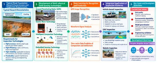
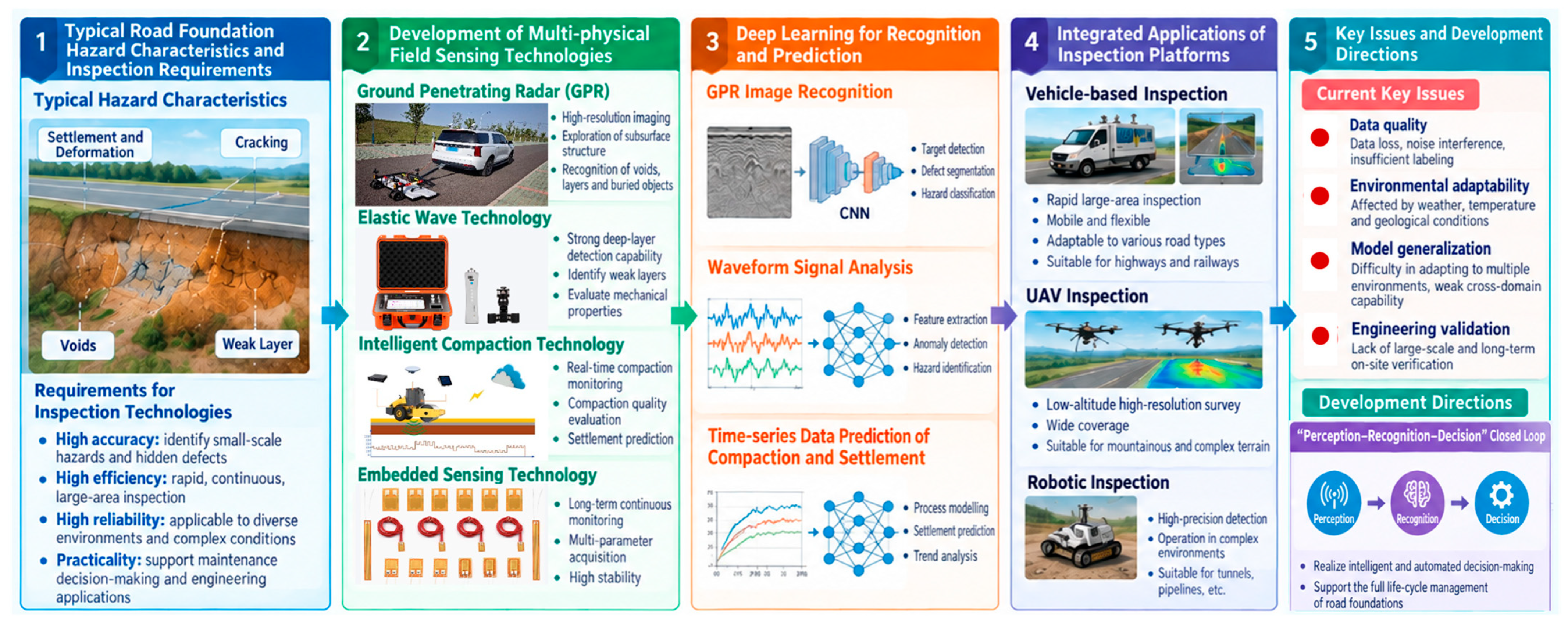
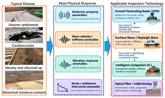
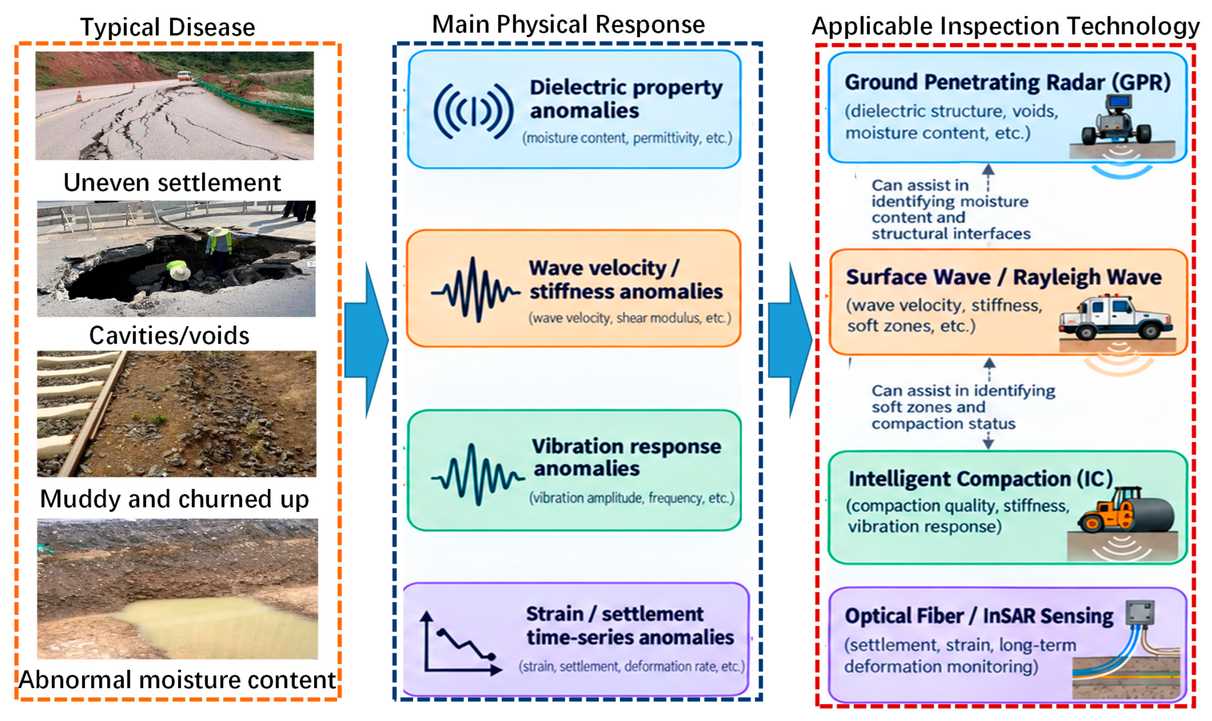
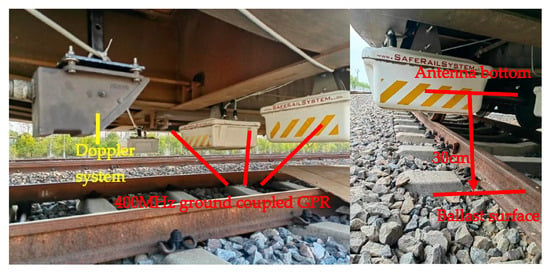
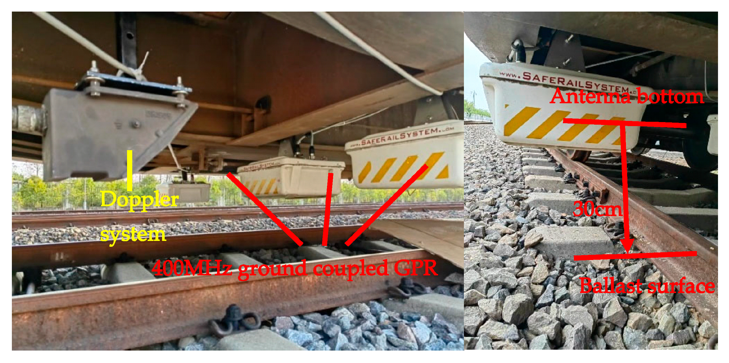
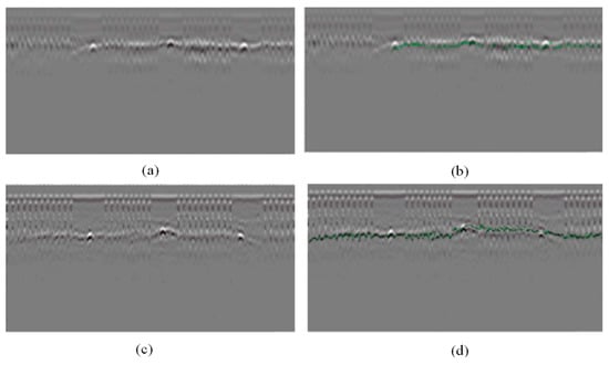
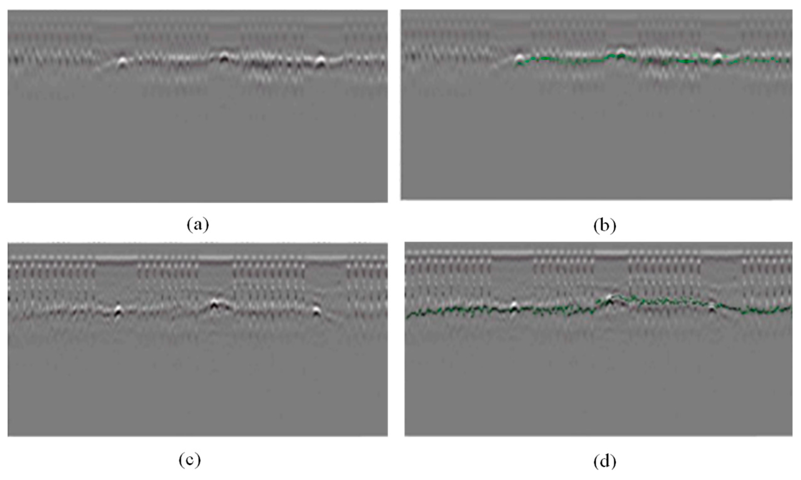
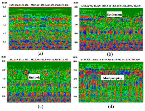
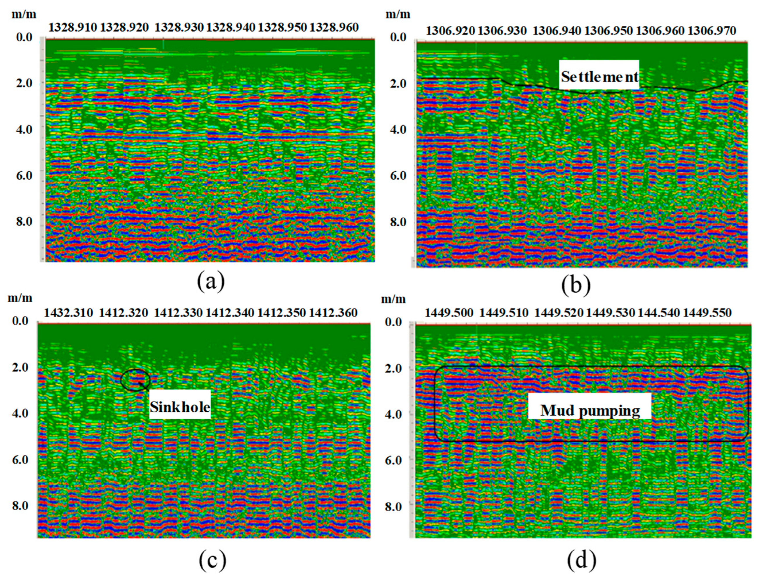
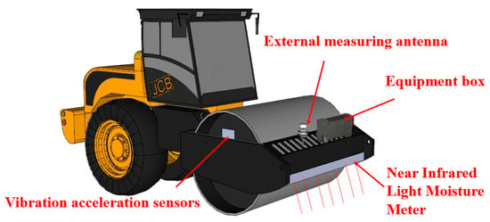
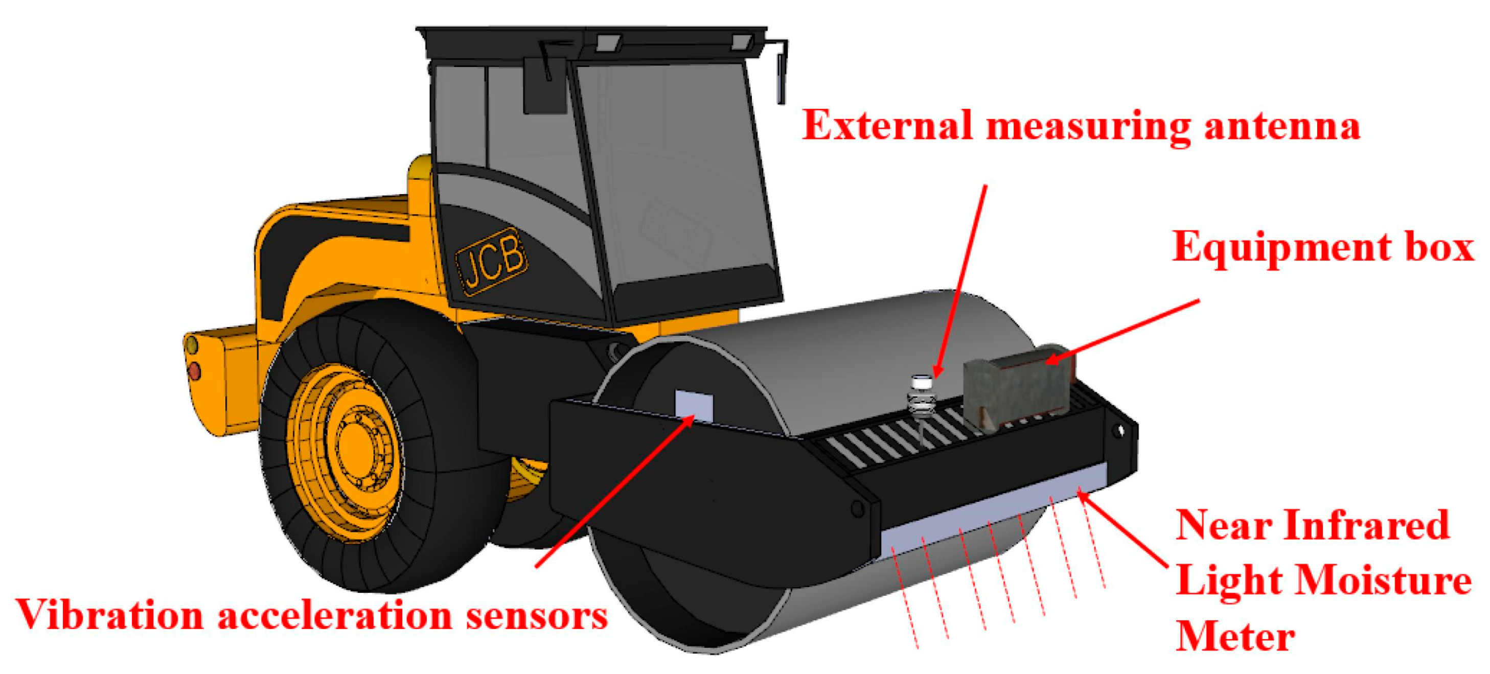
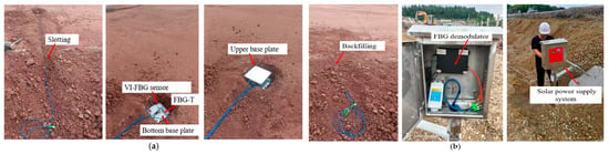
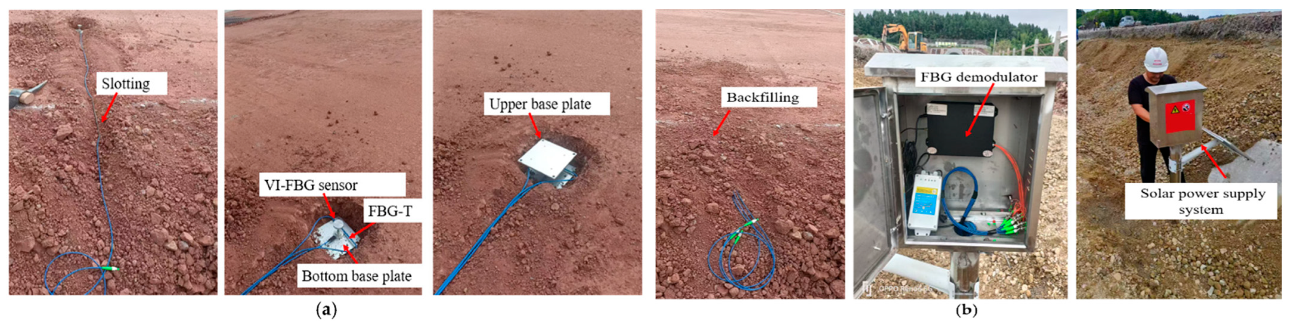
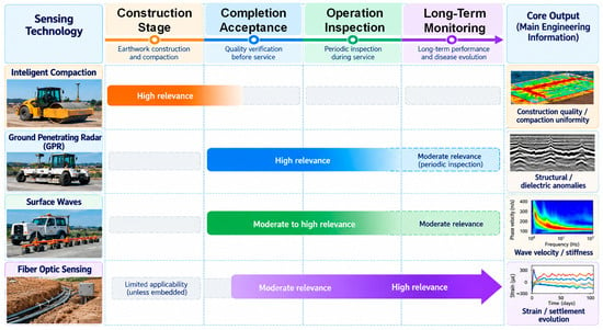
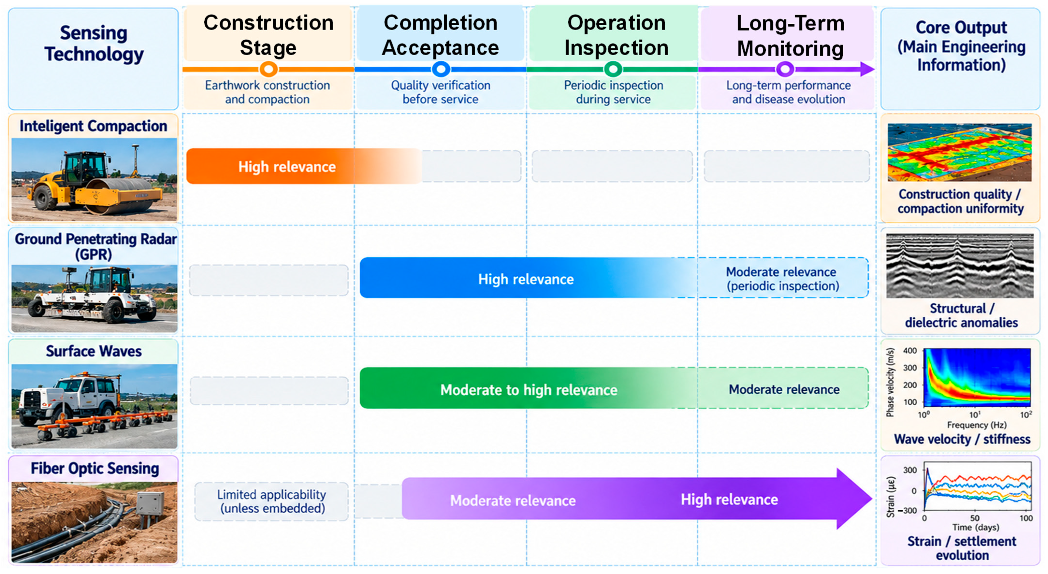
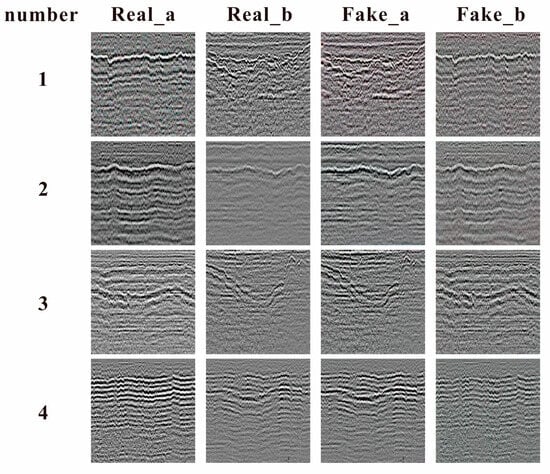
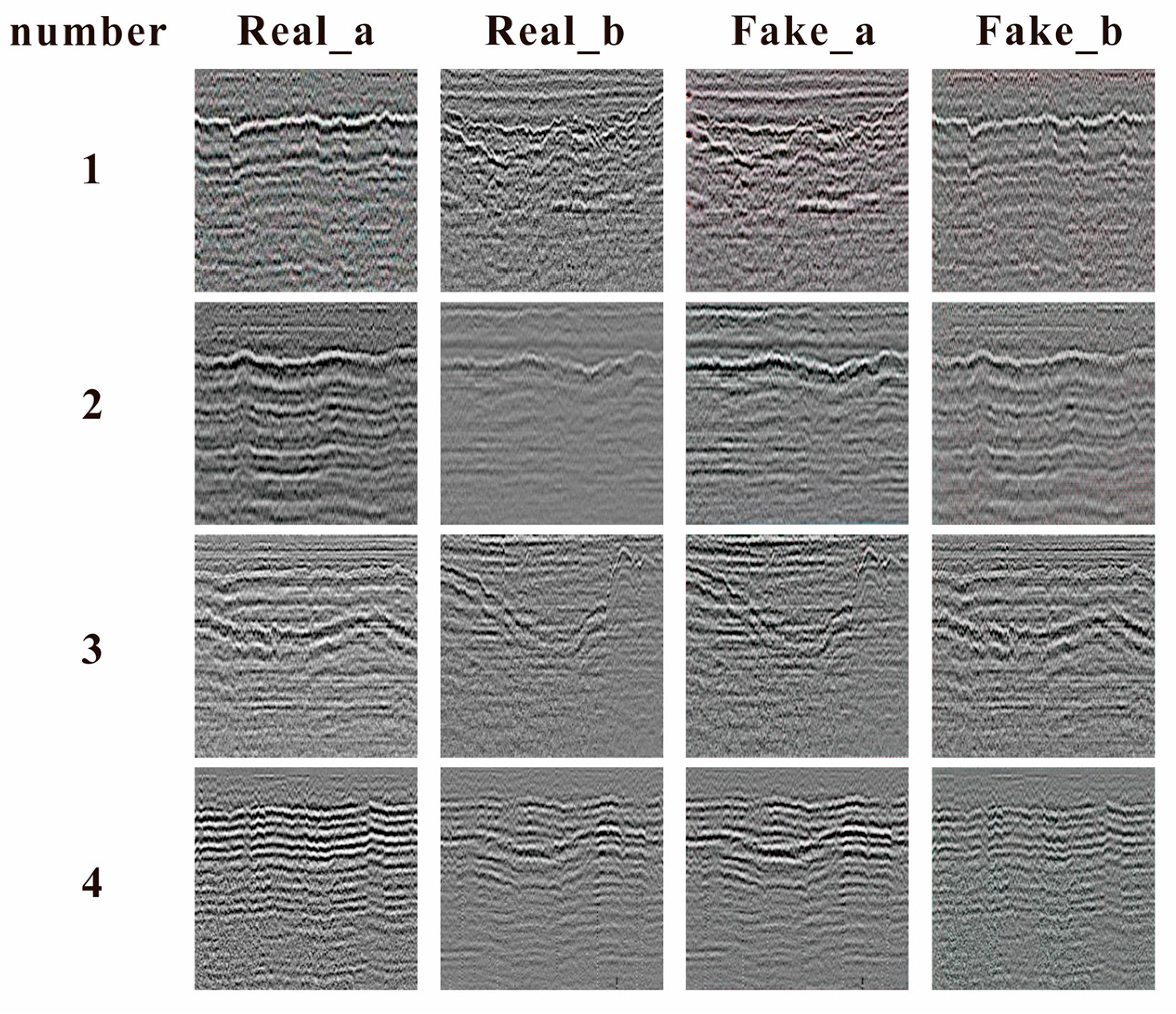
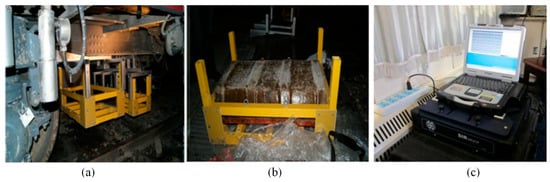
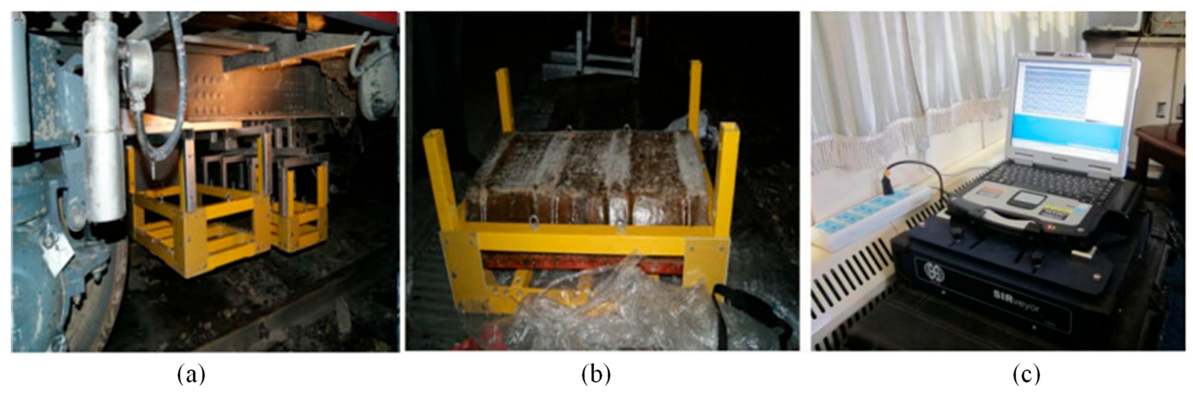

Disclaimer/Publisher’s Note: The statements, opinions and data contained in all publications are solely those of the individual author(s) and contributor(s) and not of MDPI and/or the editor(s). MDPI and/or the editor(s) disclaim responsibility for any injury to people or property resulting from any ideas, methods, instructions or products referred to in the content. |
© 2026 by the authors. Licensee MDPI, Basel, Switzerland. This article is an open access article distributed under the terms and conditions of the Creative Commons Attribution (CC BY) license.