


Abstract
This study theoretically investigates the role of plant moisture content and its spatial heterogeneity in wildfire dynamics using Cellular Automata models. The model incorporates varying moisture levels and ignition probabilities across different grid configurations, including homogeneous moisture grids and heterogeneous setups with elliptical and segmented high-moisture zones. The relationship between moisture content and ignition probability is modeled using a nonlinear formulation, reflecting threshold-like combustion dynamics observed in real ecosystems. Simulation results show that introducing high-moisture zones significantly reduces the rate of fire spread, with segmented configurations providing the most effective firebreaks. In this context, the ‘suppression effect’ denotes the reductions in forward spread and total burned area attributable to high-moisture regions acting as low-ignitability barriers. The effect is more pronounced when ignition probability depends nonlinearly on moisture, since the nonlinear mapping produces a steeper decline in ignitability above a critical moisture range, which reduces successful transmission across the barrier and increases the likelihood of fire isolation. In particular, the results highlight how modeling can be used as a decision-support tool for the strategic placement of firebreaks. By evaluating alternative spatial configurations of moisture, the approach helps identify barrier designs that maximize containment effectiveness while minimizing ecological and economic costs. This positions the methodology not only as a theoretical contribution but also as a practical framework for guiding firebreak planning and wildfire prevention policies. While the model successfully captures critical fire dynamics, its assumptions of static moisture content and simplified environmental conditions warrant further investigation. Future work will focus on integrating real-time moisture data and refining parameters with observational wildfire data to enhance the model’s predictive capabilities. This study provides valuable insights into the interplay between moisture content and wildfire spread, contributing to the development of decision-support tools for effective wildfire management.
1. Introduction
Wildfires pose a significant global challenge, causing extensive damage to ecosystems, economies, and human lives [1,2]. They are among the most dangerous natural disasters, characterized by complex and often unpredictable behavior. While human activity is a major cause of wildfires, natural factors such as drought, wind, lightning strikes, and topography also play critical roles in their ignition and spread. Addressing this multifaceted problem requires a multidisciplinary approach, with contributions from fields such as engineering, ecology, computer science, and mathematics [3].
The spread of wildfires is influenced by several factors, including meteorological conditions, vegetation type, topography, and human activity [4,5]. Among these, the moisture content of vegetation is particularly important [6,7]. Moisture content directly affects the ignitability, sustainability, and combustibility of vegetation. Lower moisture levels increase flammability, leading to more intense fires, while higher moisture content reduces the risk and extent of fire spread.
Recent advances in remote sensing, computing, and data-driven methods have improved wildfire monitoring and expanded the range of modeling and decision-support tools available; however, accurate prediction of wildfire growth remains challenging due to strong sensitivity to uncertain inputs (e.g., wind variability, vegetation characteristics acting as fuel (type, structure, and moisture content), and spotting) and complex fire–atmosphere feedbacks [8,9,10,11,12]. Consequently, many operational and research models are used primarily for scenario exploration, risk mapping, and comparative evaluation of mitigation strategies rather than deterministic, long-horizon forecasts [13,14].
Recent work has further emphasized the importance of uncertainty-aware and coupled fire–atmosphere modeling approaches, highlighting the limits of deterministic prediction under highly variable environmental conditions [15]. In parallel, landscape-scale modeling studies have demonstrated that increased spatial heterogeneity in Woody fuels (fuel) distribution and structure can significantly reduce fire spread and overall fire risk, underlining the value of spatially explicit models for informing fuel management and planning strategies [16].
Key approaches include: (i) remote sensing using satellite imagery to track vegetation and fire-related indicators (e.g., NDVI, land-surface temperature, and thermal anomalies) [3,17,18]; (ii) in situ and IoT sensing of real-time environmental variables (e.g., temperature, humidity, wind, and smoke-related indicators) to support early detection and situational awareness [12,19,20]; (iii) statistical and machine-learning methods (e.g., neural networks and support vector machines) for ignition/risk prediction and mapping of high-risk regions [1,3,21]; and (iv) fire-spread simulation models that incorporate fuels, wind, and landscape effects to assess fire dynamics and test mitigation strategies [16,22,23,24,25].
1.1. Study Focus and Contribution
This paper focuses on the application of Cellular Automata (CA) models to simulate wildfire spread, specifically examining the role of plant moisture content. Moisture content serves as a critical variable influencing fire behavior, affecting how easily vegetation ignites and how long it sustains combustion. By simulating the effects of varying moisture levels, CA models provide valuable insights into wildfire behavior and support improved risk assessment and management strategies. In particular, vegetation with high moisture content can act as a natural barrier or decelerator to wildfire spread, as it is less prone to ignition and releases energy more slowly, thereby reducing fire intensity and limiting the rate at which flames propagate across the landscape.
Cellular Automata models are particularly valuable for wildfire simulation because they can incorporate multiple variables that influence fire dynamics, including vegetation characteristics, wind patterns, topography, and plant moisture content [2,22,26]. By isolating and adjusting the moisture content parameter, this study evaluates the impact of moisture levels on the rate of fire spread, variations in the shape and size of burned areas and the effectiveness of fire-fighting tactics under different moisture scenarios.
The ability of vegetation to ignite and sustain combustion, commonly referred to as flammability, is heavily influenced by moisture content [27]. By using CA models to investigate this relationship, the study contributes to a deeper understanding of wildfire dynamics and provides insights that may inform more effective wildfire management and mitigation strategies.
In this study, we use the term firebreak to denote a natural or constructed barrier intended to stop or check fire spread or to provide a control line, whereas a fuel break refers to a natural or manmade modification of fuel characteristics designed to alter fire behavior so that fire can be more readily controlled [28].
The primary aim of this study is to investigate how plant moisture content and its spatial distribution influence wildfire spread using Cellular Automata models. Unlike previous work, this study systematically evaluates multiple spatial configurations—including homogeneous, elliptical, and segmented high-moisture zones—and explicitly incorporates a nonlinear moisture–ignition relationship to reflect threshold-like combustion dynamics. The novelty of the approach lies in combining spatially explicit modeling with nonlinear ignition effects to reveal how the arrangement of moist vegetation can act as effective firebreaks, providing actionable insights for fire management. This framework not only advances theoretical understanding of fire dynamics under heterogeneous moisture conditions but also offers a practical methodology for evaluating barrier designs and optimizing vegetation management strategies in fire-prone landscapes.
1.2. Background and Related Work
The difficulty of predicting wildfire behavior has motivated a broad range of monitoring and modeling approaches, including remote sensing, in situ sensing, data-driven prediction, and computational fire-spread simulation [3,12,19,21,29,30]. Recent advances in machine learning and hybrid modeling frameworks, combined with improvements in observational data, have further strengthened wildfire risk assessment and forecasting capabilities by integrating empirical, physical, and data-driven methodologies [29,30].
Among simulation approaches, Cellular Automata (CA) models are widely used because they represent the landscape as a grid of interacting cells and can efficiently capture local spread processes over large spatial domains [16,22,25,31]. In typical CA wildfire models, each cell transitions between states (e.g., unburned, burning, burned) according to neighborhood-based rules, allowing the influence of fuels and environmental conditions to be incorporated through probabilistic or rule-based formulations [24,31]. This class of models remains relevant within modern wildfire modeling frameworks, where it is often used alongside more complex physics-based and hybrid approaches [30,32].
Beyond their computational utility, forest fires have long been recognized as classical examples of complex systems exhibiting self-organized criticality (SOC), in which small ignition events can trigger cascades of fires of all sizes [33]. SOC behavior emerges from threshold dynamics in fuel accumulation and spatial interactions, leading to scale-invariant patterns of fire spread. Recent theoretical and computational studies have further demonstrated non-trivial behaviors in CA forest-fire models, including multistability and sensitivity to initial conditions and parameters [34,35]. These findings are consistent with modern perspectives on wildfire systems as nonlinear, multi-scale processes influenced by coupled environmental and structural factors [32,36].
Previous CA studies have explored the effects of fuel type and load (or density), moisture content, and weather forcing on fire propagation [2,5,27,37]. In parallel, machine-learning methods have been widely applied to estimate ignition likelihood, predict fire spread, and generate fire-risk maps from meteorological and remote sensing data, often complementing traditional simulation approaches [1,3,21,29]. More recent reviews highlight the increasing integration of empirical simulators, dynamic models, and ML-based techniques into unified frameworks for wildfire prediction and management [30].
Additionally, IoT and wireless sensor networks have been investigated for near-real-time detection and situational awareness in fire-prone landscapes, enabling improved monitoring and early warning capabilities [12,19,20]. These technologies further contribute to the growing ecosystem of wildfire modeling and management tools that combine sensing, prediction, and simulation.
Barrier-based mitigation has also received significant attention. Firebreaks and fuel breaks are commonly planned using GIS-based analysis, optimization methods, and empirical assessment [4,5,37]. However, many approaches rely on static assumptions or require costly field information. In contrast, CA-based frameworks enable systematic, repeatable testing of alternative barrier configurations under controlled conditions, providing a flexible environment for comparative evaluation of firebreak designs. This aligns with recent modeling trends that emphasize the use of simulation-based experiments to evaluate spatial heterogeneity and mitigation strategies under controlled and reproducible scenarios [30,32].
2. Materials and Methods
2.1. Cellular Automata Model Design
To simulate wildfire spread, a Cellular Automata (CA) model was developed, incorporating essential components such as landscape representation, cell states, transition rules, and environmental parameters.
The landscape is modeled as a two-dimensional grid of square cells, each representing a fixed area of terrain. Square cells were selected for computational simplicity. Hexagonal cellular automata have also been adopted in wildfire spread modeling to mitigate grid-induced anisotropy and provide more isotropic neighborhood connectivity [38,39]. The grid resolution is set by the cell size, which determines the spatial detail that can be represented. Smaller cells can capture finer-scale heterogeneity and fire-front structure, but increase computational cost because the number of cells (and neighbor evaluations per time step) grows rapidly as cell size decreases; larger cells reduce runtime at the expense of spatial detail [24,31].
Each cell is assigned one of four states: Fuel (flammable vegetation), Burning (currently burning), Burnt (fuel consumed), or Empty (non-combustible terrain such as rock or water).
Transitions between states are defined by rules that consider both the current state of a cell and the states of its neighbors. Key transition principles include the following. Burning cells can ignite adjacent fuel cells. The ignition probability is influenced by vegetation type, density, and moisture content. A burning cell remains in that state for one time step before transitioning to burnt. Once a cell is burned, it cannot reignite. Regeneration occurs on much longer time scales and is not considered in this simulation. Empty cells do not ignite or contribute to fire spread.
The probability that a cell ignites is based on on four parameters, the base probability of ignition (), the Vegetation Type (), Vegetation Density () and Moisture Content ().
Values for and are taken from the work of Alexandridis [22] and set as constants throughout all the scenarios. is set to 0.2 for both high-moisture and low-moisture areas and is set to 0 to represent normal plant density.
The ignition probability is calculated as:
where:
with being the base rate of spread (m/s), t the time step (min), and the cell size (m); the factor converts the time step to seconds.
Here, , t, and define the mapping from a physical rate of spread to a dimensionless baseline transition factor. Specifically, min and m set the temporal and spatial discretization of the CA grid, so that one simulation step represents one hour of propagation across kilometer-scale landscape units. The value m/s is used as an effective baseline spread-rate parameter to scale such that the resulting baseline ignition factor remains in a plausible probabilistic range () and yields fire growth over a numerically stable number of time steps for comparative scenario analysis. Because the objective of this study is comparative (assessing the effect of moisture heterogeneity and ignition formulations), these discretization parameters are kept fixed across all scenarios.
To account for the effect of plant moisture content on ignition, a moisture-dependent ignition modifier is introduced (Equation (3)). The functional form of follows the nonlinear regression model proposed in [22], where the coefficients a and b were obtained from experimental burn data. In this formulation, denotes the vegetation moisture content expressed as a percentage, and represents a dimensionless multiplier applied to the baseline ignition probability. It should be noted that this study does not aim to define a specific absolute moisture threshold for ignition. Instead, the emphasis is placed on relative differences in moisture content between vegetation types. Accordingly, in our simulations, a representative moisture difference of 30% was adopted to evaluate its impact on fire spread dynamics.
The nonlinear structure reflects the well-established suppression effect of fuel (vegetation) moisture on combustion, whereby increasing moisture content reduces fire spread in a strongly nonlinear—often exponential—manner, primarily due to the additional energy required for heating and evaporating water prior to ignition [40,41]. Within the cellular automaton framework, is implemented as a multiplicative adjustment to the local ignition probability, thereby representing the reduction in fire transmission likelihood due to increased fuel moisture.
where MC is the moisture content of the tree as a decimal.
Thus, the equation for calculating the ignition probability becomes:
For clarity, cells containing no fuel are assigned a zero ignition probability at initialization.
To compare different simulation setups, the percent burned area per step is used:
where n represents the total number of time steps, is the area burned during time step i and is the total area of the grid.
This metric allows for a quantitative comparison across different scenarios and ignition models.
To evaluate the role of plant moisture content and its spatial distribution in wildfire propagation, three theoretical forest scenarios were developed. These scenarios provide a systematic framework for assessing how different moisture configurations influence fire behavior, particularly ignition likelihood, fire spread, and containment dynamics.
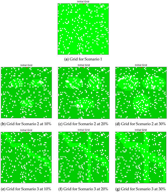
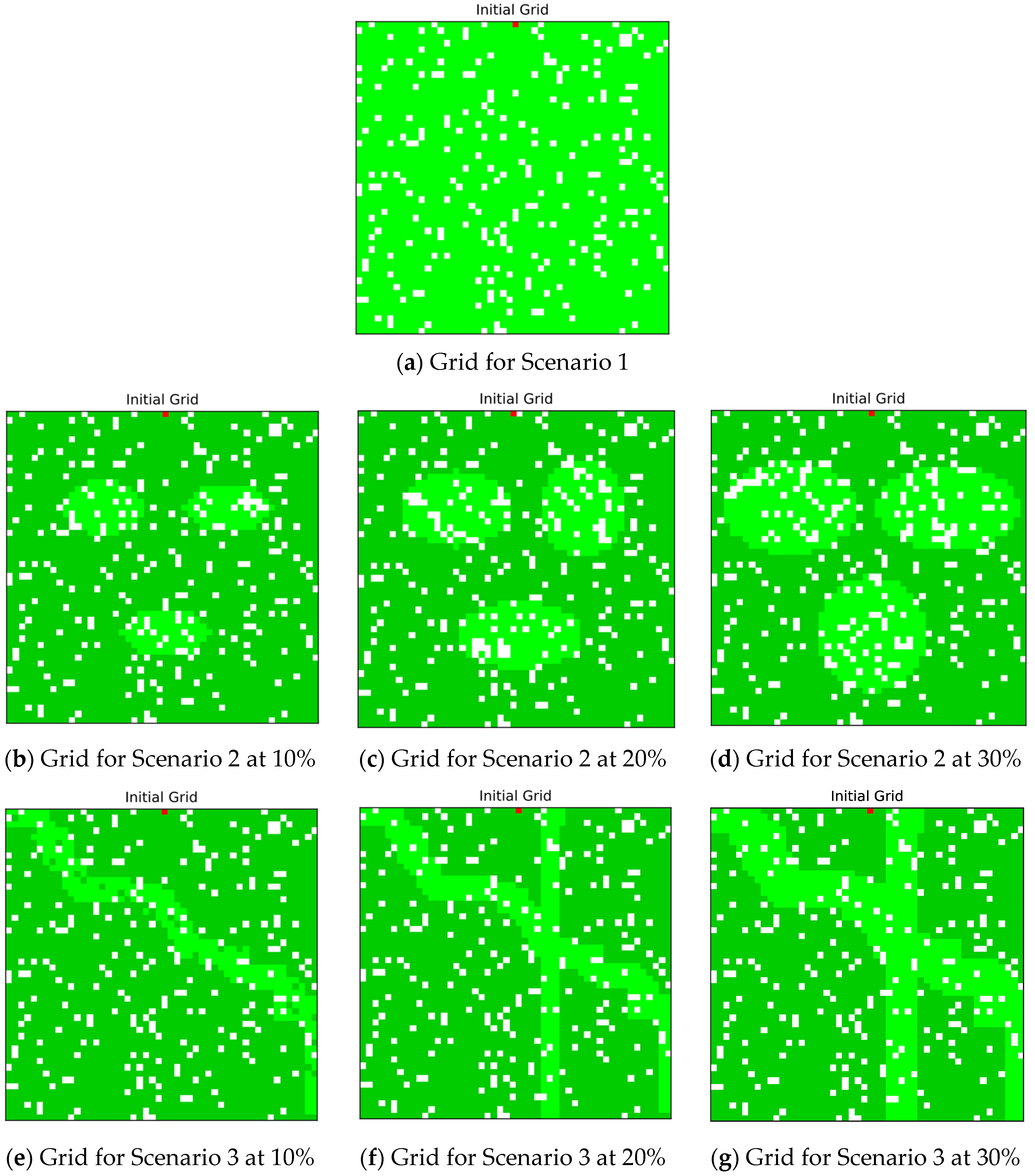
The first scenario (Scenario 1) assumes a homogeneous distribution of moisture across the entire grid, serving as a control case in which fire behavior is not influenced by spatial moisture variability (Figure 1a). This configuration represents a forest ecosystem with uniformly distributed environmental conditions, providing a baseline for comparison with more heterogeneous moisture patterns. As such, Scenario 1 is intended for qualitative comparison rather than quantitative equivalence in average moisture with other scenarios. As such, Scenario 1 serves primarily as a qualitative baseline to illustrate uniform spread dynamics.
Figure 1.
Composition of theoretical forest grids. (a) Homogeneous distribution of moisture across the entire grid, serving as a control case with uniform environmental conditions, similar to well-irrigated plantations or highly uniform natural stands. (b–d) Grid with three elliptical high-moisture zones, representing localized wetter microenvironments such as wetlands or shaded valleys. (e–g) Grid compartmentalized by continuous high-moisture zones forming linear barriers, mimicking natural firebreaks like moist valleys or fire-resistant vegetation corridors. Color scheme: light green indicates high-moisture areas, dark green indicates lower-moisture areas, white cells represent the absence of trees, and red marks the initial ignition point of the fire.
The second scenario (Scenario 2) introduces spatial heterogeneity by embedding three elliptical high-moisture zones within the grid (Figure 1b–d). These zones simulate localized increases in moisture, such as those associated with wetlands, shaded valleys, or other naturally moist microenvironments. This scenario examines whether discrete high-moisture patches can locally inhibit fire propagation or redirect fire spread toward adjacent, drier regions.
The third scenario (Scenario 3) explores the effect of continuous high-moisture zones acting as barriers across the landscape. In this configuration, high-moisture regions are arranged in linear structures that compartmentalize the grid into distinct sections, while maintaining the same total high-moisture coverage as in Scenario 2 (Figure 1e–g). These continuous barriers mimic natural or managed firebreaks, such as moist valleys or corridors of fire-resistant vegetation, and are designed to assess how spatial alignment of moisture can limit fire progression across the landscape.
To examine the influence of total high-moisture coverage, simulations were conducted for 10%, 20%, and 30% grid coverage while preserving near-identical spatial configurations. This allows assessment of whether observed differences are robust across varying levels of modified fuel fraction.
We hypothesize that continuous high-moisture barriers are more effective at limiting wildfire spread than scattered high-moisture patches, and increasing overall fuel moisture results in an overall reduction in burned area. These hypotheses guide the comparative evaluation of the three moisture scenarios.
2.2. Computational Environment and Implementation
The Cellular Automata simulations were implemented in Python 3.11. The model was coded in an object-oriented structure, with each cell represented as a class instance containing attributes such as state (unburned, burning, burned, or high-moisture), vegetation density, wind effect, terrain slope, and moisture content.
Key libraries used include NumPy 2.3.5 for numerical array and grid operations, Matplotlib 3.10.8 for visualization of grid states and fire spread heatmaps, CSV for exporting simulation results, and Random and Math for stochastic ignition events and probability calculations.
Randomness in the simulations, such as stochastic fire spread, was controlled by fixing the random number generator seed. For reproducibility, a step-by-step pseudocode Algorithm A1 of the cellular automata wildfire model, along with a table of key parameters, is provided (in Appendix A.1 and Appendix A.2).
The ignition probability was computed at each time step using both environmental parameters and a nonlinear moisture suppression factor. Simulations were run for multiple scenarios (uniform, elliptical, and segmented high-moisture distributions), with results averaged across runs to reduce stochastic variability. Random seeds were fixed to ensure reproducibility.
3. Results and Discussion
The simulation outcomes clearly illustrate how both the spatial arrangement of plant moisture and the functional form of its relationship to ignition probability crucially influence wildfire dynamics. Across three contrasting configurations, the model isolates the impact of moisture heterogeneity and fire spread mechanics, with heatmaps offering spatial insights and average burned area profiles highlighting temporal trends. All reported results are averages over multiple independent simulation runs (e.g., 100 simulations per scenario), ensuring statistical robustness; variability between runs is minimal due to the controlled setup and fixed random seed, so the reported averages accurately reflect the model behavior.
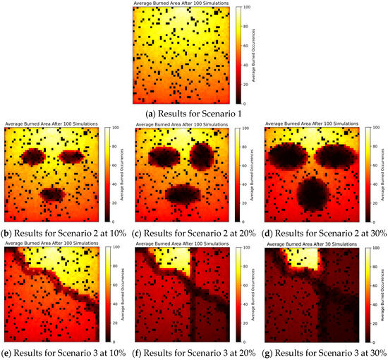
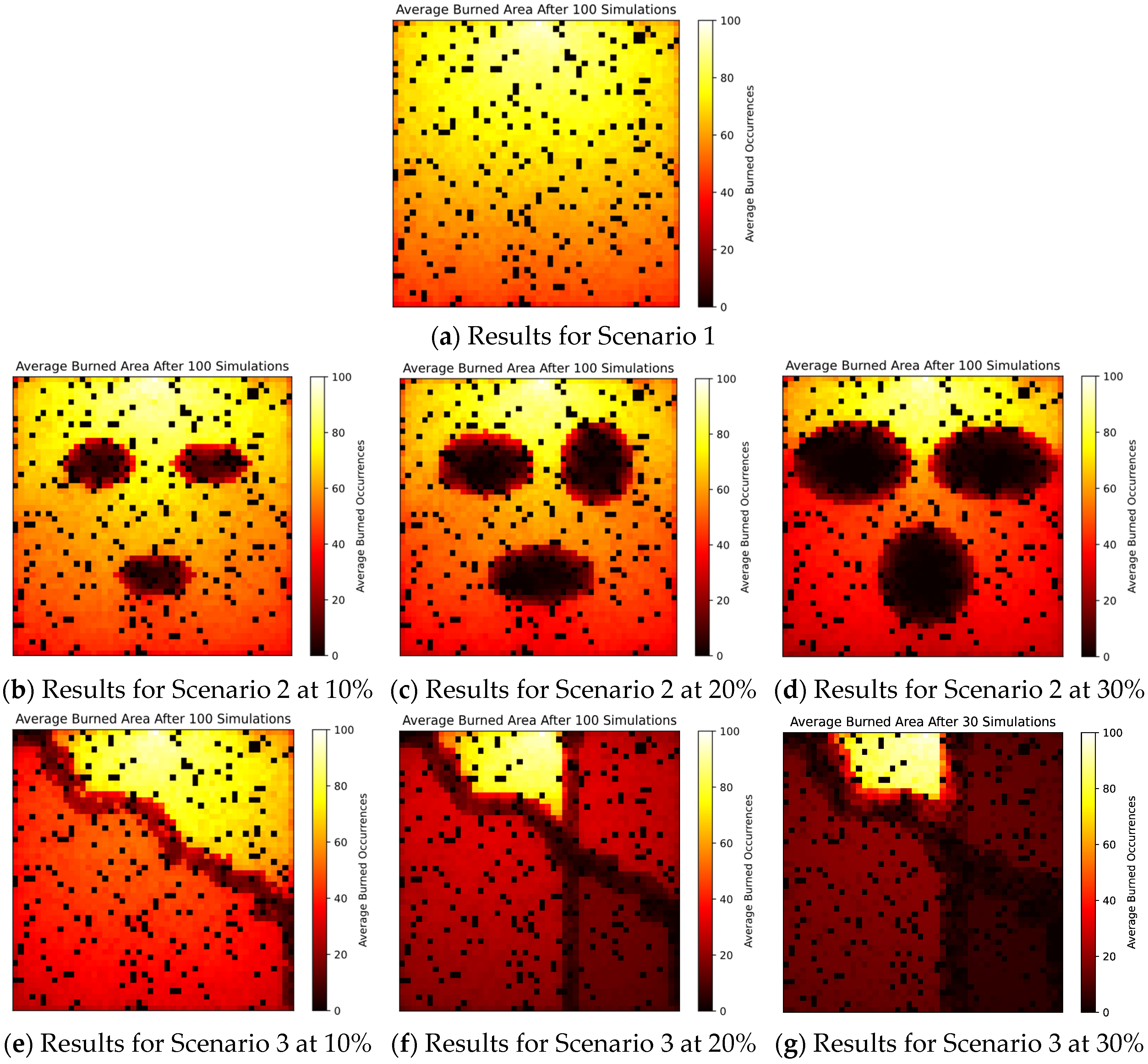
In Scenario 1 (Figure 2a), which features a homogeneous moisture distribution, fire spreads rapidly and symmetrically across the domain. The burned area shows a smooth gradient from the ignition point outward, reflecting a lack of barriers to ignition. This case acts as a baseline: it confirms the model’s behavior under neutral, unimpeded conditions and illustrates how extensively fire can spread in the absence of moisture-driven reduction in ignitability.
Figure 2.
Heatmaps of burned areas for the different scenarios. (a) Fire behavior under homogeneous moisture distribution, showing baseline spread patterns. (b–d) Fire behavior with elliptical high-moisture zones, illustrating localized dampening effects. (e–g) Fire behavior with continuous linear high-moisture barriers, showing landscape compartmentalization and firebreak behavior.
In Scenario 2 (Figure 2b–d), localized high-moisture zones are introduced, producing visible disruptions in the fire front. The elliptical moist regions act as suppression zones, reducing ignition probability within and slightly beyond their immediate boundaries. As a result, fire propagation becomes fragmented and nonlinear, with burned regions forming irregular patches around the moisture zones. This demonstrates how even isolated high-moisture areas can significantly alter fire dynamics, redirecting spread patterns and lowering overall fire intensity. This behavior is consistent with empirical wildfire studies demonstrating strong moisture-threshold effects, where ignition probability declines sharply and may approach zero once fuel moisture exceeds critical levels, significantly reducing fire spread and combustion intensity [42,43].
Scenario 3 (Figure 2e–g) intensifies the spatial structure of moisture by implementing continuous, segmented barriers across the domain. Despite covering the same total moist area as Scenario 2, these linear features provide a far more effective firebreak. The heatmap shows fire largely confined to one or two compartments, with the moist barriers preventing cross-contamination between regions. This demonstrates the profound influence of moisture structure, not just quantity, on fire suppression. It represents the most effective containment outcome among the three, confirming that spatial continuity and barrier alignment are critical in halting fire spread.
The results suggest clear guidelines for forest managers. Homogeneous landscapes (Scenario 1) provide no protection, while isolated moist patches (Scenario 2) offer only partial suppression, acting as temporary buffers. In contrast, continuous high-moisture zones (Scenario 3) deliver a systemic advantage: they compartmentalize the forest and prevent fire transfer between regions, even when covering the same total area as Scenario 2. This finding has strong practical relevance, firebreaks are most effective when designed as continuous linear barriers rather than scattered patches. The modeling framework therefore offers a computationally efficient way to evaluate alternative layouts and to optimize firebreak design under resource and ecological constraints.
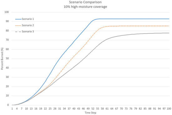
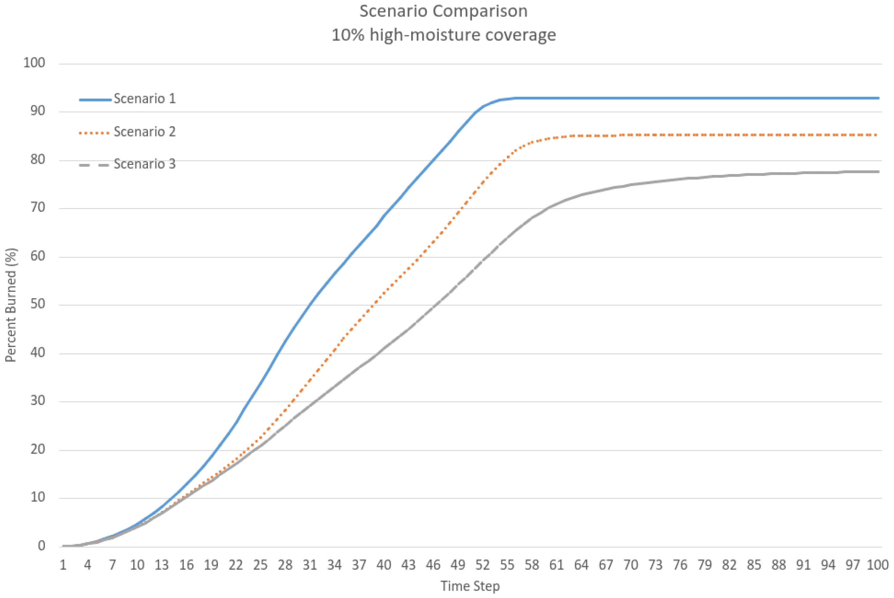
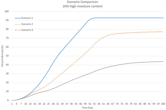
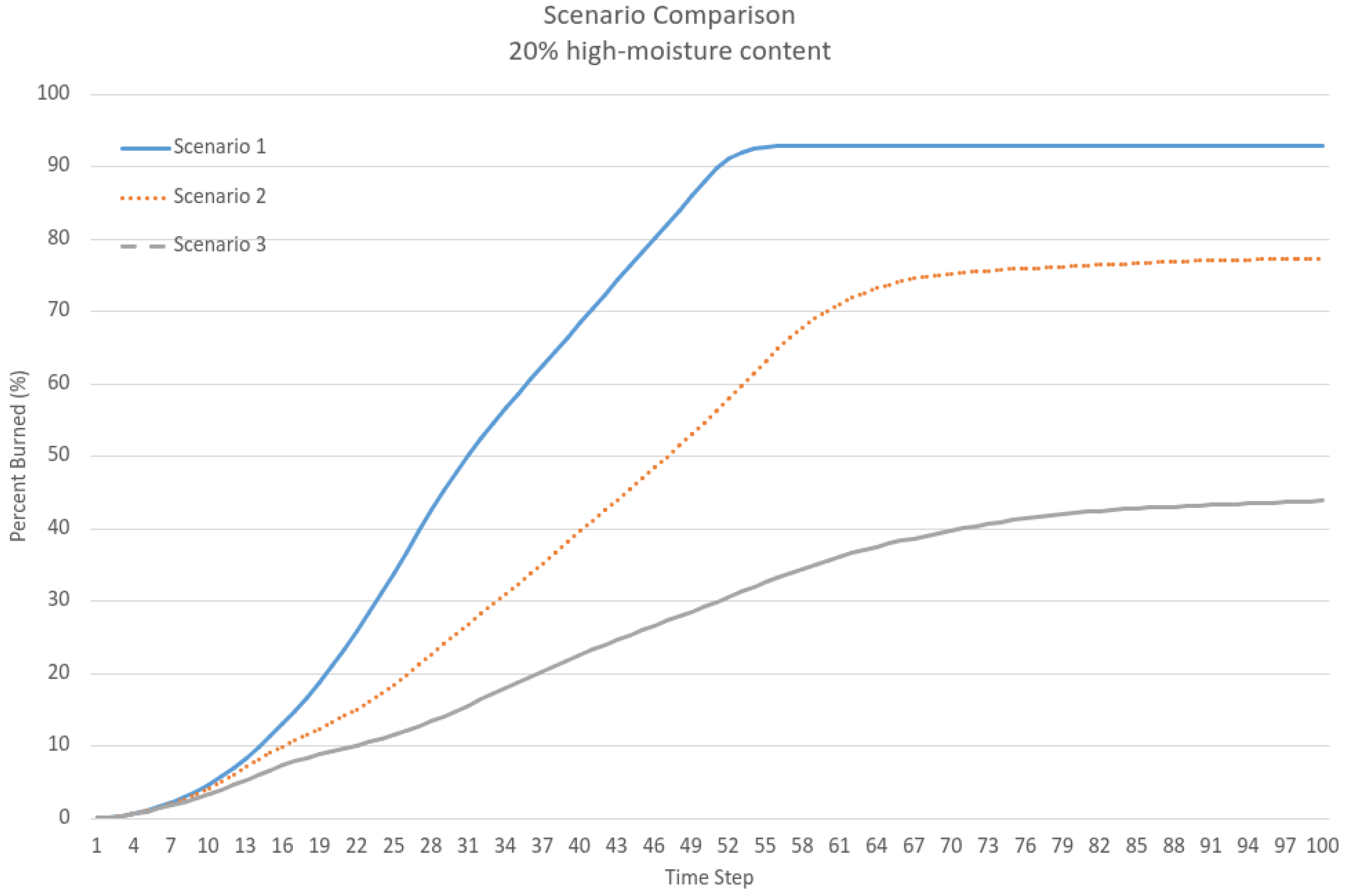
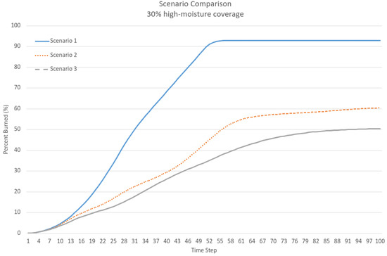
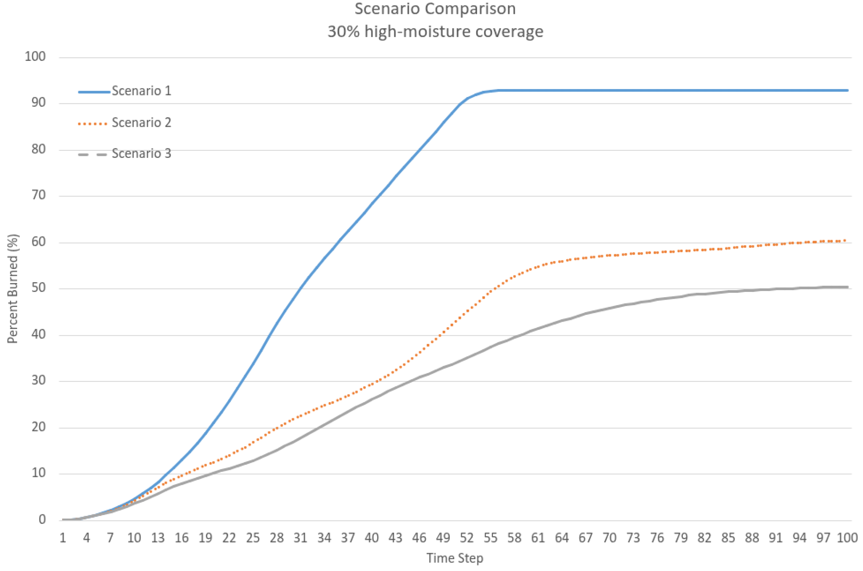
The quantitative profiles (Figure 3, Figure 4 and Figure 5) support these visual results. Scenario 1 consistently shows the highest burned area per timestep, while Scenario 2 shows moderate reductions due to fragmented moisture. Scenario 3 consistently exhibits the lowest cumulative burned area per timestep, confirming the effectiveness of structured, continuous moist zones as barriers to fire propagation. However, for high-moisture coverages of 20% and 30%, the cumulative burned area remains relatively similar (45% and 50%, respectively).
Figure 3.
Numerical comparison of scenarios at 10% high-moisture coverage.
Figure 4.
Numerical comparison of scenarios at 20% high-moisture coverage.
Figure 5.
Numerical comparison of scenarios at 30% high-moisture coverage.
This behavior can be attributed to the stochastic nature of the Cellular Automata simulations and the spatial dynamics of fire spread. Even with 100 simulation runs, variability arises from the probabilistic ignition process and the local interactions governing fire propagation. At these intermediate coverage levels, increasing high-moisture coverage from 20% to 30% does not necessarily produce a proportional reduction in burned area, as the effectiveness of the moist zones depends not only on their extent but also on their spatial configuration and connectivity.
As a result, the observed difference between 45% and 50% falls within the expected variability of the system. Importantly, the overall trend remains consistent, as Scenario 3 continues to outperform the other scenarios in limiting fire spread.
These findings yield two key insights. First, moisture heterogeneity alone is insufficient—its spatial configuration and connectivity are essential. Dispersed or irregular moist patches offer limited resistance, whereas strategically aligned barriers can provide systemic fire containment. Second, the nonlinear relationship between moisture and ignition probability is critical. Abrupt ignition suppression observed in high-moisture zones supports the inclusion of threshold-based or nonlinear ignition models in wildfire simulations.
It should be noted that direct comparisons with operational wildfire models (e.g., FARSITE, FlamMap, or physics-based simulators) are outside the scope of this study, as the focus is on idealized, theoretical forest scenarios rather than real landscapes. Similarly, field observations are not applicable in this context. Nevertheless, the simulations provide robust insights into the role of spatial moisture heterogeneity and barrier configurations in controlling fire spread, highlighting generalizable dynamics that can guide future experimental or modeling studies.
From a practical perspective, the results suggest that land and vegetation management could benefit from spatially informed moisture interventions. Techniques such as targeted irrigation, planting fire-resistant species, or conserving natural wet corridors could serve as passive yet powerful firebreaks—especially if designed with spatial continuity in mind. Even small increases in vegetation moisture, if correctly aligned, can dramatically reduce fire spread due to the nonlinear ignition response.
In summary, this study highlights the importance of integrating spatial structure and nonlinear ignition dynamics into fire modeling frameworks. It emphasizes the role of ecologically grounded, spatially explicit strategies in wildfire mitigation, providing a strong foundation for future predictive and management-oriented fire simulation tools.
4. Limitations
Although the model captures essential aspects of fire behavior, several limitations remain. One key simplification is the assumption of static moisture content. In reality, moisture levels are dynamic, changing in response to environmental factors such as rainfall, wind, and evapotranspiration [1,31]. Incorporating real-time or time-varying moisture data would improve model realism and predictive accuracy.
Another limitation is the reliance on abstract parameterization rather than empirical data. While useful for conceptual analysis, future models should integrate observational data—such as remote sensing or field measurements—to better calibrate ignition probabilities, fuel loads, and moisture variability [20]. Further improvements could include incorporating topographical effects and wind patterns into the CA framework, calibrating model parameters with historical wildfire data, and applying the model to real geographic areas using GIS inputs.
5. Conclusions
This study demonstrates the effectiveness of using Cellular Automata to investigate how plant moisture content and its spatial distribution affect wildfire dynamics. By modeling homogeneous, elliptical, and segmented high-moisture scenarios, the results clearly show that spatial heterogeneity in moisture content significantly alters fire behavior. Key findings include: high-moisture zones reduce fire spread, acting as natural suppressants; segmented moisture configurations serve as effective firebreaks that limit cross-region propagation; and nonlinear ignition models amplify the suppression effect, yielding the smallest burned areas across all scenarios. While only three representative geometric configurations are analyzed in this study, future work could explore a wider variety of landscape geometries and barrier arrangements to investigate more complex fire dynamics.
Beyond theoretical insights, this study emphasizes the operational potential of Cellular Automata models as decision-support tools for wildfire prevention. By explicitly demonstrating how barrier continuity enhances containment, the model provides a framework for identifying ideal firebreak arrangements in real landscapes. Practical applications include restoration or conservation of wetlands, targeted irrigation of high-risk areas, and the planting of higher-moisture-content vegetation, which can act as spatially continuous, passive firebreaks. Coupled with GIS data and optimization algorithms, future applications could generate spatially explicit firebreak designs tailored to specific ecosystems. This aligns modeling with practice, bridging the gap between mathematical simulation and ecological management in the fight against wildfires. Moreover, these results not only provide practical guidance for the design and placement of firebreaks but also reinforce theoretical insights from complex systems and Cellular Automata modeling, demonstrating how spatial heterogeneity can produce non-trivial fire suppression patterns.
Author Contributions
Conceptualization and early supervision, M.A. (Markos Avlonitis), N.A. and M.A. (Marios Anagnostou) contributed equally to all aspects of this work. All authors have read and agreed to the published version of the manuscript.
Funding
This research received no external funding.
Data Availability Statement
The original contributions presented in this study are included in the article. Further inquiries can be directed to the corresponding authors.
Acknowledgments
We are deeply saddened by the sudden passing of our supervisor and co-author, Markos Avlonitis. We dedicate this work to him in recognition of his inspiring guidance and his pivotal role in conceiving the idea for this research.
Conflicts of Interest
The authors declare no conflicts of interest.
Appendix A
Appendix A.1. Pseudocode of the Cellular Automata Wildfire Model
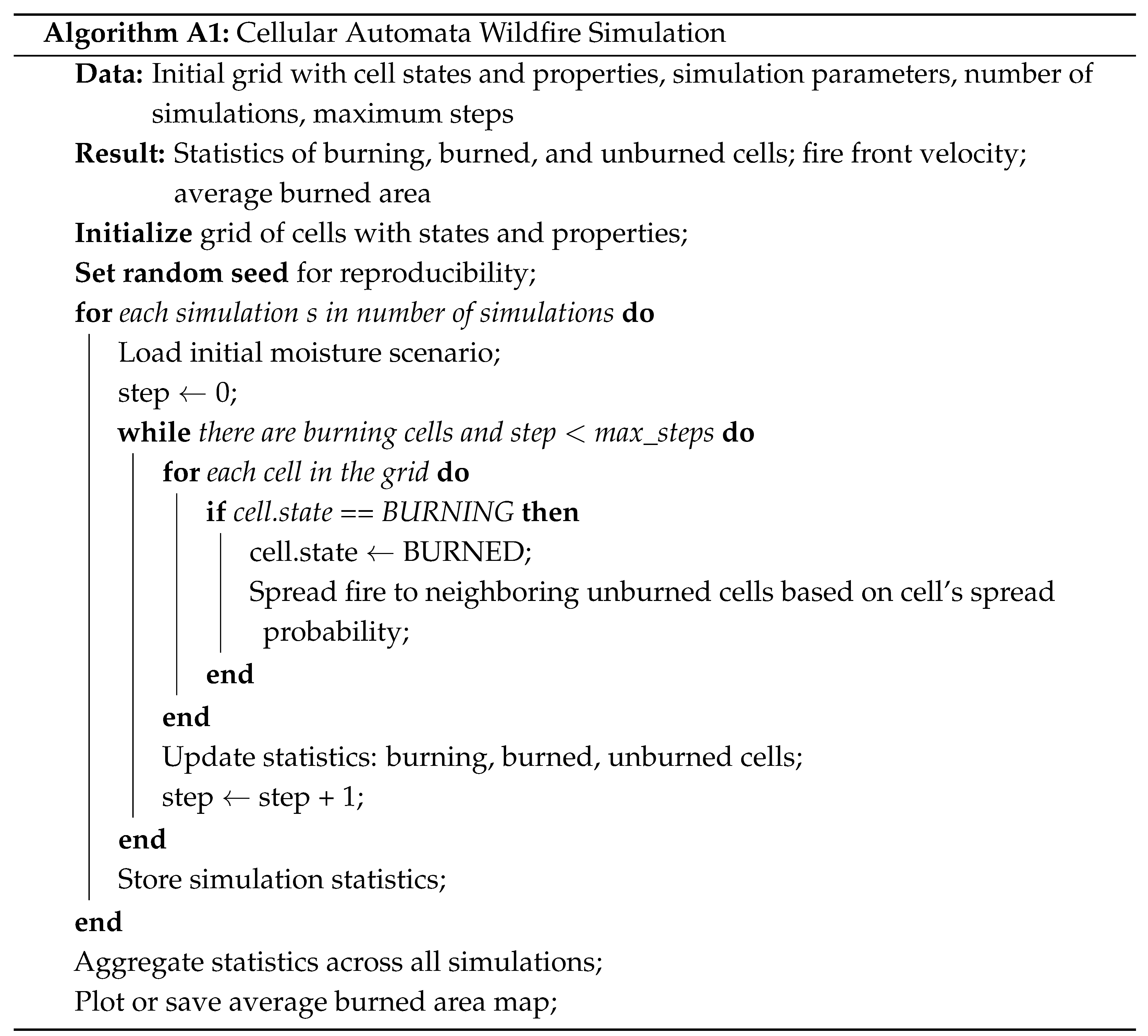 |
Appendix A.2. Model Parameters
Table A1.
Main parameters used in the cellular automata wildfire model.
Appendix A.3. Reproducibility Notes
To ensure reproducibility of the simulations:
- The starting point is fixed for all simulations.
- Randomness in fire spread is controlled using a fixed random seed.
- Pseudocode and parameters allow independent implementation of the model in any programming language.
- Full Python code is not shared, but all essential logic and parameters are provided for replication purposes.
References
- Cortez, P.; Morais, A. A Data Mining Approach to Predict Forest Fires using Meteorological Data. In Proceedings of the 13th Portuguese Conference on Aritficial Intelligence, EPIA 2007, Guimarães, Portugal, 3–7 December 2007. [Google Scholar]
- Mutthulakshmi, K.; Wee, M.R.E.; Wong, Y.C.K.; Lai, J.W.; Koh, J.M.; Acharya, U.R.; Cheong, K.H. Simulating forest fire spread and fire-fighting using cellular automata. Chin. J. Phys. 2020, 65, 642–650. [Google Scholar] [CrossRef] [Scilit]
- Sayad, Y.; Mousannif, H.; Al Moatassime, H. Predictive modeling of wildfires: A new dataset and machine learning approach. Fire Saf. J. 2019, 104, 130–146. [Google Scholar] [CrossRef] [Scilit]
- Ager, A. Wildfire risk estimation in the Mediterranean area. Environmetrics 2014, 25, 386–398. [Google Scholar] [CrossRef] [Scilit]
- Gill, A.M.; Zylstra, P. Flammability of Australian forests. Aust. For. 2005, 68, 87–93. [Google Scholar] [CrossRef] [Scilit]
- Zhou, M.; Vacik, H. Comparisons of fuel stick moisture among forest cover types in eastern Austria. Austrian J. For. Sci. 2017, 2017, 301–321. [Google Scholar]
- Anne, G.; Camia, A.; Jappiot, M.; San-Miguel-Ayanz, J.; Long-Fournel, M.; Lampin, C. A Review of the Main Driving Factors of Forest Fire Ignition Over Europe. Environ. Manag. 2013, 51, 651–662. [Google Scholar] [CrossRef] [Scilit]
- Sullivan, A.L. Wildland surface fire spread modelling, 1990–2007. 1: Physical and quasi-physical models. Int. J. Wildland Fire 2009, 18, 349–368. [Google Scholar] [CrossRef] [Scilit]
- Sullivan, A.L. Wildland surface fire spread modelling, 1990–2007. 2: Empirical and quasi-empirical models. Int. J. Wildland Fire 2009, 18, 369–386. [Google Scholar] [CrossRef] [Scilit]
- Morvan, D. Fifty years of progress in wildland fire modelling: From empirical to fully physical CFD models. C. R. Mécanique 2022, 350, 107–115. [Google Scholar] [CrossRef] [Scilit]
- Coen, J.L.; Cameron, M.; Michalakes, J.; Patton, E.G.; Riggan, P.J.; Yedinak, K.M. WRF-Fire: Coupled Weather–Wildland Fire Modeling with the Weather Research and Forecasting Model. J. Appl. Meteorol. Climatol. 2013, 52, 16–38. [Google Scholar] [CrossRef] [Scilit]
- Kizilkaya, B.; Ever, E.; Yatbaz, H.Y.; Yazici, A. An Effective Forest Fire Detection Framework Using Heterogeneous Wireless Multimedia Sensor Networks. ACM Trans. Multimed. Comput. Commun. Appl. 2022, 18, 1–21. [Google Scholar] [CrossRef] [Scilit]
- Finney, M.A. FARSITE: Fire Area Simulator—Model Development and Evaluation; Research Paper RMRS-RP-4; U.S. Department of Agriculture, Forest Service, Rocky Mountain Research Station: Ogden, UT, USA, 1998. [Google Scholar]
- Tymstra, C.; Bryce, R.W.; Wotton, B.M.; Taylor, S.W.; Armitage, O.B. Development and Structure of Prometheus: The Canadian Wildland Fire Growth Simulation Model; Information Report NOR-X-417; Natural Resources Canada, Canadian Forest Service, Northern Forestry Centre: Edmonton, AB, Canada, 2010. [Google Scholar]
- Coen, J.L.; Johnson, G.W.; Romsos, J.S.; Saah, D. A Framework for Conducting and Communicating Probabilistic Wildland Fire Forecasts. Fire 2024, 7, 227. [Google Scholar] [CrossRef] [Scilit]
- Zelnik, Y.R.; Launiainen, S.; Vico, G. Managing for heterogeneity reduces fire risk in boreal forest landscapes—A model analysis. Ecol. Model. 2025, 509, 111222. [Google Scholar] [CrossRef] [Scilit]
- Arroyo, L.; Pascual, C.; Manzanera, J.A. Fire models and methods to map fuel types: The role of remote sensing. For. Ecol. Manag. 2008, 256, 1239–1252. [Google Scholar] [CrossRef] [Scilit]
- Bajocco, S.; Rosati, L.; Ricotta, C. Knowing fire incidence through fuel phenology: A remotely sensed approach. Ecol. Model. 2010, 221, 59–66. [Google Scholar] [CrossRef] [Scilit]
- Brito, T.; Pereira, A.I.; Lima, J.; Valente, A. Wireless Sensor Network for Ignitions Detection: An IoT approach. Electronics 2020, 9, 893. [Google Scholar] [CrossRef] [Scilit]
- Toledo-Castro, J.; Caballero-Gil, P.; Rodríguez-Pérez, N.; Santos-González, I.; Hernández-Goya, C.; Aguasca-Colomo, R. Forest Fire Prevention, Detection, and Fighting Based on Fuzzy Logic and Wireless. Complexity 2018, 2018, 1639715. [Google Scholar] [CrossRef] [Scilit]
- Wu, Z.; Wang, B.; Li, M.; Tian, Y.; Quan, Y.; Liu, J. Simulation of forest fire spread based on artificial intelligence. Ecol. Indic. 2022, 136, 108653. [Google Scholar] [CrossRef] [Scilit]
- Alexandridis, A.; Russo, L.; Vakalis, D.; Bafas, G.V.; Siettos, C.I. Wildland fire spread modelling using cellular automata: Evolution in large-scale spatially heterogeneous environments under fire suppression tactics. Int. J. Wildland Fire 2011, 20, 633–647. [Google Scholar] [CrossRef] [Scilit]
- Li, X.; Zhang, M.; Zhang, S.; Liu, J.; Sun, S.; Hu, T.; Sun, L. Simulating Forest Fire Spread with Cellular Automation Driven by a LSTM Based Speed Model. Fire 2022, 5, 13. [Google Scholar] [CrossRef] [Scilit]
- Clarke, K.; Brass, J.A.; Riggan, P.J. A cellular automaton model of wildfire propagation and extinction. Photogramm. Eng. Remote Sens. 1994, 60, 1355–1367. [Google Scholar]
- Karafyllidis, I.; Thanailakis, A. A model for predicting forest fire spreading using cellular automata. Ecol. Model. 1997, 99, 87–97. [Google Scholar] [CrossRef] [Scilit]
- Fares, S.; Mereu, S.; Scarascia Mugnozza, G.; Vitale, M.; Manes, F.; Frattoni, M.; Ciccioli, P.; Gerosa, G.; Loreto, F. The ACCENT-VOCBAS field campaign on biosphere-atmosphere interactions in a Mediterranean ecosystem of Castelporziano (Rome): Site characteristics, climatic and meteorological conditions, and eco-physiology of vegetation. Biogeoscie 2009, 6, 1043–1058. [Google Scholar] [CrossRef] [Scilit]
- Dimitrakopoulos, A. A statistical classification of Mediterranean species based on their flammability components. Int. J. Wildland Fire 2001, 10, 113–118. [Google Scholar] [CrossRef] [Scilit]
- Natural Resources Conservation Service (NRCS). Conservation Practice Standard: Firebreak (Code 394); Technical Report; USDA NRCS: Washington, DC, USA, 2022. [Google Scholar]
- Jain, P.; Coogan, S.C.; Subramanian, S.G.; Crowley, M.; Taylor, S.; Flannigan, M.D. A review of machine learning applications in wildfire science and management. Environ. Rev. 2020, 28, 478–505. [Google Scholar] [CrossRef] [Scilit]
- Singh, H.; Ang, L.M.; Paudyal, D.; Acuna, M.; Srivastava, P.K.; Srivastava, S.K. A Comprehensive Review of Empirical and Dynamic Wildfire Simulators and Machine Learning Techniques used for the Prediction of Wildfire in Australia. Technol. Knowl. Learn. 2025, 30, 935–968. [Google Scholar] [CrossRef] [Scilit]
- Yassemi, S.; Dragićević, S.; Schmidt, M. Design and implementation of an integrated GIS-based cellular automata model to characterize forest fire behaviour. Ecol. Model. 2008, 210, 71–84. [Google Scholar] [CrossRef] [Scilit]
- Hantson, S.; Kelley, D.I.; Arneth, A.; Harrison, S.P.; Archibald, S.; Bachelet, D.; Forrest, M.; Hickler, T.; Lasslop, G.; Li, F.; et al. Quantitative assessment of fire and vegetation properties in simulations with fire-enabled vegetation models from the Fire Model Intercomparison Project. Geosci. Model Dev. 2020, 13, 3299–3318. [Google Scholar] [CrossRef] [Scilit]
- Malamud, B.; Morein, G.; Turcotte, D. Forest Fires: An Example of Self-Organized Critical Behavior. Science 1998, 281, 1840–1842. [Google Scholar] [CrossRef] [Scilit]
- Czechowski, Z.; Budek, A.; Białecki, M. Bi-SOC-states in one-dimensional random cellular automaton. Chaos Interdiscip. J. Nonlinear Sci. 2017, 27, 103123. [Google Scholar] [CrossRef] [Scilit]
- Rybski, D.; Butsic, V.; Kantelhardt, J.W. Self-organized multistability in the forest fire model. Phys. Rev. E 2021, 104, L012201. [Google Scholar] [CrossRef] [Scilit]
- Or, D.; Furtak-Cole, E.; Berli, M.; Shillito, R.; Ebrahimian, H.; Vahdat-Aboueshagh, H.; McKenna, S.A. Review of wildfire modeling considering effects on land surfaces. Earth-Sci. Rev. 2023, 245, 104569. [Google Scholar] [CrossRef] [Scilit]
- Vakalis, D.; Sarimveis, H.; Kiranoudis, C.; Alexandridis, A.; Bafas, G. A GIS based operational system for wildland fire crisis management I. Mathematical modelling and simulation. Appl. Math. Model. 2004, 28, 389–410. [Google Scholar] [CrossRef] [Scilit]
- Hernández Encinas, L.; Hoya White, S.; Martín del Rey, A.; Rodríguez Sánchez, G. Modelling forest fire spread using hexagonal cellular automata. Appl. Math. Model. 2007, 31, 1213–1227. [Google Scholar] [CrossRef] [Scilit]
- Trunfio, G.A. Predicting Wildfire Spreading Through a Hexagonal Cellular Automata Model. In Cellular Automata (ACRI 2004); Lecture Notes in Computer Science; Springer: Berlin/Heidelberg, Germany, 2004; Volume 3305, pp. 385–394. [Google Scholar] [CrossRef] [Scilit]
- Asensio, M.; Cascón, J.; Laiz, P.; Prieto-Herráez, D. Validating the effect of fuel moisture content by a multivalued operator in a simplified physical fire spread model. Environ. Model. Softw. 2023, 164, 105710. [Google Scholar] [CrossRef] [Scilit]
- Awad, C.; Morvan, D.; Rossi, J.L.; Marcelli, T.; Chatelon, F.J.; Morandini, F.; Balbi, J.H. Fuel moisture content threshold leading to fire extinction under marginal conditions. Fire Saf. J. 2020, 118, 103226. [Google Scholar] [CrossRef] [Scilit]
- Masinda, M.M.; Sun, L.; Wang, G.; Hu, T. Moisture content thresholds for ignition and rate of fire spread for various dead fuels in northeast forest ecosystems of China. J. For. Res. 2021, 32, 1147–1155. [Google Scholar] [CrossRef] [Scilit]
- Ganteaume, A.; Lampin-Maillet, C.; Guijarro, M.; Hernando, C.; Jappiot, M.; Fontúrbel, T.; Pérez-Gorostiaga, P.; Vega, J.A. Spot fires: Fuel bed flammability and capability of firebrands to ignite fuel beds. Int. J. Wildland Fire 2009, 18, 951–969. [Google Scholar] [CrossRef] [Scilit]
Disclaimer/Publisher’s Note: The statements, opinions and data contained in all publications are solely those of the individual author(s) and contributor(s) and not of MDPI and/or the editor(s). MDPI and/or the editor(s) disclaim responsibility for any injury to people or property resulting from any ideas, methods, instructions or products referred to in the content. |
© 2026 by the authors. Licensee MDPI, Basel, Switzerland. This article is an open access article distributed under the terms and conditions of the Creative Commons Attribution (CC BY) license.