


Abstract
Salt-bearing foreland fold–thrust belts represent a critical tectonic system for ultra-deep hydrocarbon exploration. In the Kalasu structural belt of the Kuqa Depression—characterized by the “four extremes” of ultra-high temperature, pressure, salinity, and stress—conventional single-detachment models fail to adequately resolve the complex subsalt structures. To address this challenge, this study integrates high-resolution 3D seismic data, field outcrop observations, well logs, balanced cross-sections, and particle image velocimetry (PIV)-monitored physical modeling to propose a ramp–flat multi-detachment model. Our results demonstrate that deformation is governed by four regional detachment horizons: gypsum-salt layers, thick mudstones, coal-bearing strata, and the basement, which vertically partition the basin into six tectonic units: supra-salt, salt, subsalt, supra-coal, coal, and sub-coal basement. The structural architecture is controlled by five key factors: (1) paleo-uplift geometry, (2) distance from the South Tianshan orogenic front, (3) orientation of basin-bounding faults, (4) regional stress regime (pure compression versus transpression), and (5) rheological contrasts among detachment layers. The kinematic evolution follows a progressive sequence: basement-involved thrusting → multi-level ramp–flat detachment folding → cover detachment. Three primary trap levels are identified—subsalt, supra-coal, and sub-coal—hosting six distinct trap styles: pop-up anticlines, imbricate faulted anticlines, structural triangle zones, fault-bend fold anticlines, supra-coal anticlines, and inter-coal/sub-coal anticlines. Notably, under transpressional stress, oblique paleo-uplifts control the formation of enigmatic “fish-scale” arcuate trap belts composed of fault-bend fold anticlines.
1. Introduction
Hydrocarbon exploration has progressively shifted toward deep and ultra-deep domains, particularly within complex salt-bearing foreland basins, where accurate characterization of trap geometry and seal effectiveness is fundamental to successful discovery. The Kuqa Depression, located on the northern margin of the Tarim Basin in northwestern China, serves as a critical basin–mountain transition zone linking the Tarim Craton and the South Tianshan Orogen [1]. It represents a natural laboratory for investigating ultra-deep structural complexities under extreme “four-ultra” conditions: ultra-high temperature, ultra-high pressure, ultra-high salinity, and ultra-high stress [1]. As illustrated in Figure 1, the regional tectonic framework of the Kuqa Depression is delineated by several key structural units. The inset map locates the study area within the broader context of the Tarim Basin and northwestern China. The main panel explicitly shows the architecture of the depression, which is subdivided from west to east into the Kela–Keshen, Bozi–Dabei, and Qiulitag structural belts. This study focuses on the Kelasu Structural Belt (Figure 1) (encompassing the Kela–Keshen and Bozi–Dabei segments), which hosts the deepest known hydrocarbon accumulations in the region [2].
Figure 1.
(a) Location of China; (b) Location of the Tarim Basin and Kuqa Depression; (c) tectonic subdivision of the Kuqa Depression.
Exploration strategies in the Kelasu Structural Belt have undergone three major transitions: (i) target intervals shifted from supra-salt to subsalt strata [3]; (ii) the key exploration area migrated from the Kela–Keshen segment to the Bozi–Dabei segment; and (iii) structural models evolved from fault-related folding theory to compressional salt-tectonics, and more recently to structural transfer zone concepts. Despite these advances, refined structural modeling of the subsalt Mesozoic sequences remains a significant challenge [4]. Traditional models, predominantly based on a single evaporite detachment layer, fail to explain the pronounced shallow–deep structural decoupling and the diverse distribution of trap styles observed in ultra-deep settings [5]. Consequently, the mechanisms controlling ultra-deep trap formation remain poorly constrained, resulting in high exploration risk.
Recent drilling data (e.g., Wells KL2, YN2, Bozi-5, and Dabei-26) and high-resolution seismic interpretations reveal that the Cretaceous Bashijiqike Formation and the underlying Jurassic coal measures possess distinct mechanical properties, enabling them to act as independent detachment horizons [6,7]. This implies a ramp–flat multi-detachment model rather than a single-layer model [8]. However, the kinematic evolution of such a system—and its specific control on complex trap architectures, particularly the formation of “fish-scale” arcuate belts and structural triangle zones—has not been quantitatively addressed [9,10].
To bridge this gap, this study proposes a novel ramp–flat multi-detachment model for the deep subsalt Kuqa Depression. Integrating field geological investigations of Mesozoic outcrops, 3D seismic interpretation, and quantitative physical simulations monitored by Particle Image Velocimetry (PIV), we systematically investigate how ramp–flat multi-detachment models govern trap formation. We identify five key controls on deformation architecture: (1) paleo-uplift geometry, (2) distance from the South Tianshan orogenic front, (3) orientation of basin-bounding faults, (4) regional stress regime (pure compression vs. transpression), and (5) rheological contrasts among detachment layers (gypsum-salt, mudstone, coal, and basement). Vertically, the basin is redefined into six tectonic units—supra-salt, salt, subsalt, supra-coal, coal, and sub-coal basement—within which three primary closure levels (subsalt, supra-coal, and sub-coal) host six distinct trap types. The integrated “tectonic control on traps” framework established in this work provides a transferable paradigm for ultra-deep hydrocarbon exploration in mature salt-influenced fold-and-thrust belts worldwide, such as the Zagros Fold–Thrust Belt and the Sub-Andean zones.
2. Materials and Methods
2.1. Geological Data and Seismic Interpretation
To elucidate the structural deformation styles and mechanisms beneath the salt layer in the Bozi–Dabei segment of the Kuqa Depression, our research team conducted a ten-day field geological survey in the Korla–Baicheng–Luntai–Yangxia area of the southern Tianshan Mountains. We visited ten key outcrop observation sites: Beibayi section, Pochengzi Pasture, Baozidong section, Awate River section, Tuzimazha section, Kalasu River section, Jidike anticline section, Kuche Tawu section, Yangxia section, and Dong Qiulitag section (Figure 2). The survey focused on examining the contact relationships among the Mesozoic–Cenozoic stratigraphic units and the internal structural deformation within the Mesozoic strata, with particular attention to detachment deformation features within coal-bearing series and mudstone layers. The primary objective was to obtain field geological evidence for potential detachment layers in the study area’s periphery, including the Paleogene–Neogene gypsum-salt rocks, thick Cretaceous mudstones, Jurassic–Triassic coal seams, and basement paleo-uplifts, which could facilitate the development of detachment structures.
Figure 2.
Field observation sites of detachment structures in South Tianshan.
High-resolution 3D seismic and well-logging data from the Kelasu structural belt (including wells KL2, YN2, Bozi-5, and Dabe-26) were provided by the Research Institute of Exploration and Development, PetroChina Tarim Oilfield Company. Seismic interpretation and structural modeling were performed using Petrel 2018 and Move 2018.1 software. Based on the theoretical framework of ramp–flat multi-detachment structural deformation, this study quantitatively analyzed fault dips within different lithological units and established geometric relationships controlled by rock strength. Furthermore, using cross-section balancing techniques, we reinterpreted and validated twenty-four structural framework sections from west to east across the Kuqa Depression, reconstructing the evolutionary sequence of deep-seated, complex structural deformation beneath the salt layer. This work not only further validates the applicability of the ramp–flat multi-detachment model for interpreting ultra-deep structures beneath the salt but also investigates the influence of multi-level detachment faults and their potential controlling factors on the deformation characteristics in different segments. This provides a novel methodological foundation for subsequent physical simulation experiments of multi-detachment structures under key, multi-geological-factor constraints.
2.2. Structural Physical Simulation Experiments
This study takes the Kuqa Depression as a case study. Based on the complex multi-detachment structural deformation characteristics of the ultra-deep salt-bearing foreland fold–thrust belt, we comprehensively considered the complex geological factors and their controls, categorizing them into the following three groups: (1) multi-detachment structural components, including the basement detachment layer, the Cretaceous thick mudstone detachment layer, the Paleogene–Neogene gypsum-salt plastic detachment layer, the Jurassic–Triassic coal seam brittle–ductile detachment layer, and major regional unconformities; (2) external geological conditions, including tectonic activity rate and duration, differential loading stress state, syn-tectonic sedimentation and erosion, pre-existing basement structures (e.g., paleo-uplifts, pre-existing faults, the dip, morphology, and spatial distribution of paleo-uplift slopes), boundary faults, and structural transfer zones; and (3) internal properties of detachment layers, including cohesion, frictional properties, layer strength and thickness, rheological characteristics governed by differences in rock mechanical properties, layer attitude and spatial distribution, burial depth, stratigraphic contact relationships, and the stacking sequence of multiple detachment layers. This classification framework provides a systematic basis for variable control in subsequent physical simulation experiments.
In summary, this experimental design identifies the potential factors influencing the multi-detachment structural deformation system beneath the salt in the Kuqa Depression and proposes a physical simulation experimental scheme suitable for ultra-deep, complex, multi-factor geological settings (Figure 3). The aim is to investigate the differential impacts of these controlling factors on the “geometric, kinematic, and dynamic” characteristics of structural evolution within the Kuqa foreland fold–thrust belt, thereby enabling both quantitative and qualitative characterization of the differential decoupling effects of various detachment layers to finely resolve the formation mechanisms of the complex multi-detachment structural system beneath the salt.
Figure 3.
Design scheme for physical modeling of multi-detachment structures in ultra-deep conditions.
2.2.1. Experimental Apparatus
The physical simulation experiments were conducted at the “Digital Geological Modeling Laboratory” at China University of Petroleum (Beijing), Karamay Campus. The platform utilizes a custom-built sandbox system driven by a high-precision four-cylinder stepper motor (stepping accuracy: 0.01–0.7 mm/s), capable of simulating multi-phase tectonic regimes including extension, compression, and strike-slip. The system is synchronized with an array of industrial-grade, high-resolution cameras and a Particle Image Velocimetry (PIV) monitoring system, which captures images of the model’s cross-section and plan view every 30 s. PIV analysis allows for the quantitative selection and mapping of local strain and displacement fields, dynamically tracking the decoupling processes between various detachment layers and the evolution of strain localization zones. This enables the identification of potential areas prone to intense fracturing and trap sealing, providing critical insights into the kinematic mechanisms of trap formation.
To accurately simulate the variably oriented depression boundaries of the Kuqa Depression, we adopted the following workflow for fabricating the basal model: (1) A boundary geometry model with a specific azimuthal angle was designed in 3D modeling software based on actual geological parameters; (2) The model was exported in a standard 3D printing format (e.g., STL) and printed using Polylactic Acid (PLA) as the printing material; (3) The file was imported into a high-precision 3D printer for fully automated model fabrication. This workflow achieves quantitative control over the spatial relationship between the compressive boundary and fault strike. The resulting boundary models accurately reflect the geometric characteristics of the study area (e.g., the ~30° oblique boundary in the Dabei–Keshen segment). This method offers good inheritability and high fidelity, making it applicable for physical simulations of complex boundary conditions across different segments of the Kuqa Depression, thus providing a reproducible technical protocol for realizing complex multi-detachment deformation features. Although this approach significantly enhances the realism of boundary geometry, its application is currently limited by printing scale and material rigidity, particularly in modeling areas with strong continuous curvature variations, which remains a focus of ongoing research and development.
2.2.2. Experimental Design
To systematically investigate the key geological factors controlling deep-seated, multi-detachment structural deformation beneath the salt in complex, superimposed basins like the salt-bearing foreland thrust belt, and to validate the new structural deformation models proposed in this study, we designed three series of physical simulation experiments focusing on the Kuqa Depression’s Kelasu structural belt. These series target the spatial distribution of paleo-uplifts and shortening space, the geometric differences in boundary fault strikes, and composite stress regimes (exemplified by transpressional strike-slip).
Series 1: Spatial Distribution of Paleo-uplifts and Their Distance from the Orogen.
This series focuses on the control exerted by the distance of the four major pre-existing basement paleo-uplifts in the Kuqa Depression (e.g., Wensu, Qiulitag, Xinhe, and Yaha) from the southern Tianshan orogen on sub-salt structural deformation. By presetting an “S-shaped” spatial distribution for the paleo-uplifts and varying their distance from the compressive boundary, we successfully reproduced two primary end-member structural styles observed in the study area: the “oblique wedge-stacked multi-layer detachment structure” near the compressive front, and a three-stage progressive deformation model farther from the orogen—characterized by a sequence from the orogen towards the basin of “foreland basement-involved thrust belt–ramp–flat multi-detachment transition zone–cover detachment structural belt.” This experiment provides a physical model foundation for clarifying the deep deformation mechanisms under differential paleo-uplift constraints (related results have been published elsewhere [11]).
Series 2: Geometric Differences in Depression Boundary Fault Strike.
Based on the ~30° strike of the boundary fault in the Dabei–Keshen segment, a rigid boundary fabricated via 3D printing was used to simulate oblique compression. The experiment effectively replicated the plan-view structural differentiation controlled by the boundary: “horsetail en echelon structures” with a strike-slip component formed in the obliquely compressed zone, while “fish-scale banded traps” developed in the zone of direct frontal compression. This confirms the dominant control of boundary strike geometry on the architecture of multi-detachment traps.
Series 3: Composite Stress Regime (Transpressional Strike-Slip).
To verify the genetic mechanism of the “S-shaped” en echelon traps in the Keshen–DongQiu segment, a two-stage transpressional experiment was designed: regional compression was applied first, followed by the superposition of lateral shear to simulate the strike-slip component. This design successfully reproduced the evolutionary process from early forward-propagating thrust belts to late-stage “S-shaped, left-lateral, right-stepping en echelon structures,” forming a typical positive flower structure in cross-section. This strongly supports the new understanding that “the superposition of compression and strike-slip controls the transformation of trap styles.”
The above experimental designs are tightly coupled with the key geological elements of the Kuqa Depression. They not only effectively simulate the tectonic response of the ultra-deep, multi-detachment system beneath the salt but also successfully validate, through physical models, the various new sub-salt multi-detachment structural deformation models proposed in this study, laying a solid foundation for subsequent detailed result analysis and mechanistic discussion.
2.2.3. Materials and Scaling
The experiments employed a combination of granular and viscoelastic materials to simulate the mechanical stratification of the crust: quartz sand was used to represent strong, competent layers (e.g., sandstones); micro glass beads and silicone gel simulated weak, incompetent layers (e.g., coal seams, mudstones, evaporites). The basement paleo-uplifts were modeled by mixing multi-colored quartz sand with water, which was then allowed to settle and consolidate overnight to form morphologies conforming to the preset geological conditions. Blue-dyed quartz sand was used as a marker horizon, uniformly embedded within key stratigraphic levels to facilitate the tracking of structural deformation processes. The model design adheres to the principles of geometric and kinematic similarity, with a consistent length scale ratio of 1:100,000 (i.e., 1 cm in the model corresponds to ~1 km in nature). The applied shortening rates (0.01–0.1 mm/s) correspond to geological strain rates of approximately 10−14 to 10−13 s−1, consistent with Cenozoic shortening in the Kuqa Depression. Given the use of Coulomb frictional materials and the limited model thickness (<20 cm), gravitational effects are negligible, and dynamic similarity is effectively achieved through kinematic control.
For each tectonic scenario—Awat, Bozi–Dabei, Dabei–Keshen, and Keshen–DongQiu—the corresponding analog model was independently replicated at least three times under identical material configurations and boundary conditions. All replicates produced consistent structural patterns in fault geometry, trap morphology, and uplift distribution, confirming the reproducibility of the observed kinematic evolution.
Awat Segment: To investigate the structural evolution of the Awat segment—characterized by a laterally narrowing deformation zone, an oblique intersection between the regional shortening direction and the paleo-uplift boundary, and the resulting transpressional accommodation zone with asymmetric, en échelon traps—an analog model was constructed in a sandbox measuring 600 mm (length) × 600 mm (width) × 60 mm (height). Two rigid side walls were fixed at a 70° internal angle to simulate the oblique convergence. Shortening was applied at a constant rate of 0.03 mm/s via a motor-driven piston. The model was filled with dry white quartz sand to simulate competent sedimentary strata, with uniform layering representing the supra-detachment cover sequence. High-resolution images of both cross-sectional and plan views were captured every minute using an integrated high-definition camera and Particle Image Velocimetry (PIV) system.
Bozi–Dabei Segment: To investigate the control of paleo-uplift amplitude on sub-salt structural deformation, a dual-paleo-uplift analog model was designed. The sandbox measures 600 mm × 600 mm × 200 mm, with shortening applied at 0.1 mm/s via a motor-driven movable wall; the opposite end is fixed. The model comprises three domains: a high-amplitude paleo-uplift zone (21° dip, located 150 mm from the moving wall), a low-amplitude paleo-uplift zone (9° dip, 180 mm from the moving wall), and an intervening depression. The pre-existing “S-shaped” dual-uplift basement décollement was simulated by preparing a mixture of colored quartz sands with water, consolidated overnight. Micro glass beads represented coal layers, while quartz sand simulated both supra- and sub-salt structural units. Blue quartz sand layers (2 mm thick) were inserted as kinematic markers. Deformation was documented every minute using the PIV-camera system.
Dabei–Keshen Segment: This experiment simulated oblique compression along a depression-bounding fault in a 600 mm × 600 mm × 200 mm sandbox. Shortening was applied at 0.01 mm/s via a motor-driven movable wall, with the opposite end fixed. Based on field measurements indicating a fault strike of 29.22°, the model boundary was oriented at a 30° angle relative to the shortening direction. The custom fault-bounding geometry was fabricated through a digital workflow: a parameterized 3D model was designed in CAD software, exported in STL format, and 3D-printed using polylactic acid (PLA) filament. The model was filled with a 20 mm-thick layer of quartz sand. High-resolution images were captured every 30 s to document the progressive structural evolution.
Keshen–Dongqiu Segment: To investigate how strike-slip deformation modulates structural evolution in an S-shaped en échelon fault system, a two-phase tectonic overprinting experiment was performed in a 400 mm × 600 mm × 200 mm sandbox. Phase I involved uniform orthogonal shortening (0.1 mm/s) across the entire model. At 30% bulk shortening, Phase II initiated: a plastic sheet at the model base—attached to a stepper motor—was pulled laterally at 0.33 mm/s for 150 s, generating a 50 mm strike-slip displacement while shortening continued, culminating in 31% total shortening. White quartz sand simulated sedimentary strata with variable thicknesses (60 mm near the moving wall, 40 mm near the fixed wall, and 22.5 mm in the central depression). Blue quartz sand layers served as kinematic markers, and deformation was recorded every 30 s.
3. Results
3.1. Stratigraphic Sequences and Multi-Layer Detachment Potential
The Kuqa Depression foreland thrust belt in the Tarim Basin and the southern Junggar Basin thrust belt are both key targets for ultra-deep hydrocarbon exploration in central-western China. These two belts are regressive foreland basins formed by the remote effects of the India-Asia plate collision since the Late Cenozoic, which triggered intense uplift of the Tianshan Mountains. Both exhibit vertically stacked ramp–flat multi-detachment models and share comparable tectonic settings and stratigraphic architectures. This study systematically compares the structural deformation characteristics of coal-bearing strata in surface outcrops from the foreland thrust belts north and south of the Tianshan Mountains, aiming to provide direct field evidence for detachment structures developed within coal measures. Our findings demonstrate that detachment surfaces preferentially localize within weak, incompetent layers—particularly coal-bearing strata and mudstones—thereby confirming the existence of a multi-layer detachment system beneath the primary salt layer. At the Bashikutang outcrop section in the Kuqa Depression, we report new evidence of detachment structures developed within the Lower Jurassic Ahe Formation coal measures. Similarly, at the Sikeshu River outcrop section along the southern margin of the Junggar Basin (Figure 4), which shares a comparable tectonic setting, we observed typical detachment deformation within the Middle Jurassic Xishanyao Formation coal measures.
Figure 4.
Representative field exposures of coal-measure detachment structures in foreland thrust belts north and south of the Tianshan Mountains. (a) Triassic Talqike Formation (T3t), Hutongbulake, Kuqa Depression (south of Tianshan): stratal thickening and detachment faulting in coal-bearing strata; (b) Jurassic Xishanyao Formation (J2x), Sikeshu, southern Junggar Basin (north of Tianshan): fault-bend and fault-propagation folds above a coal-seam décollement.
Statistical analysis of fault dip angles from Tarim Oilfield data reveals a systematic variation with lithological strength: 45–35° in granite/carbonate rocks, 40–25° in sandstones, 35–20° in mudstones, 20–10° in shales/coal measures, and less than 10° in evaporites. Based on this, we propose a hierarchical sequence for detachment efficacy (Figure 5): the Paleogene–Neogene gypsum-salt layers exhibit the strongest detachment, followed by the Jurassic–Triassic coal measures. In contrast, the Cretaceous Shushanhe Formation thick mudstones are identified as the weakest detachment horizon.
Figure 5.
Fault Dip Angle Ranges in Different Lithologies (Data Source: Tarim Oilfield).
Our field survey in the Kuqa Depression found no typical outcrop evidence of dominant, through-going detachment structures—such as those observed in gypsum-salt or coal-bearing strata—within the Shushanhe mudstones. Nevertheless, seismic interpretations across the Kuqa Depression indicate that these mudstones play a crucial coordinative role during multi-layer detachment. Specifically, they act as a weak but continuous layer that modulates the linkage and kinematic interaction between stronger overlying and underlying detachments (e.g., salt and coal measures). This coordinative function influences stress partitioning during non-coaxial deformation, thereby affecting the migration of structural highs and the final geometry of sub-salt traps.
Support for such a coordinative role of mudstone-dominated intervals comes from the Sikeshu River section on the southern Junggar Basin margin (Figure 6), where Jurassic Xishanyao Formation mudstones are confirmed to adjust the attitude and geometry of detachment faults, resulting in differential fold styles between hanging-wall and footwall domains and further modifying trap architecture.
Figure 6.
Characteristics of accommodative detachment in mudstone of the Jurassic Xishanyao Formation at the Sikeshu River section.
Furthermore, at the Tugerming anticline section in the Kuqa Depression, we found clear field evidence of strike-slip faulting overprinting detachment structures: a flower structure generated by strike-slip deformation cuts through a coal-seam detachment anticline (Figure 7a). This reflects the destructive reworking of early-formed detachment traps by late-stage strike-slip activity, further confirming that strike-slip tectonics is a critical factor controlling the deformation mechanisms of ramp–flat multi-detachment models. On the other hand, under intense compressional stress, the hanging wall of a pop-up structure has been overturned, forming a well-developed overturned coal-seam detachment anticline; the common footwall of the two opposing detachment faults constitutes a structural triangle zone (Figure 7b). Current exploration efforts in the Kuqa Depression foreland thrust belt are primarily focused on structural highs of imbricate thrust sheets and pop-up structures, while research on potential traps like structural triangle zones remains insufficient. Systematic studies of their fundamental geological characteristics and hydrocarbon accumulation conditions are urgently needed.
Figure 7.
Characteristics of detachment structures in the Jurassic Ahe Formation coal-bearing strata at the Tugeerming section ((a) shows the characteristics of a detachment anticline controlled by late-stage strike-slip fault reworking, while (b) illustrates the interrelationship among the structural triangular zone, counter-thrust folds, and overturned folds).
Research on the structural deformation characteristics and reservoir-controlling significance of the Cretaceous Shushanhe Formation thick mudstones—particularly how their distribution, thickness, width, and morphological variations influence deformation—is currently limited. In the ongoing Cretaceous risk-exploration campaign in the Bozi segment of the Kuqa Depression, the Botan-1 well encountered significant technical challenges, including “weak seismic reflectivity of the target horizon leading to poor identification” and “inaccurate delineation of the southern boundary fault’s location and geometry.” Consequently, the well failed to encounter the target Yagelimu Formation and instead drilled into the footwall. This highlights a key limitation of traditional thrust-fold models in guiding ultra-deep, salt-detached risk-drilling in complex structural settings.
Our study, based on the development and application of a ramp–flat multi-detachment model for the ultra-deep, complex Kuqa belt, provides a novel conceptual framework for Cretaceous deep-risk drilling deployment. The thick mudstones of the Cretaceous Shushanhe Formation, as a typical incompetent layer, undergo coordinative detachment under compressional stress. This process activates weak slip surfaces that participate in structural deformation, thereby readjusting the geometry and attitude of ramp–flat fault systems and ultimately causing the structural high of the fault-propagation anticline to shift laterally. This directly impacts the effectiveness of traps formed by the middle salt-detached source-reservoir-cap rock assemblage.
The ramp–flat fault geometry differs significantly from the previously assumed listric fault morphology, leading to markedly different exploration strategies—a key factor behind the Botan-1 well’s failure to reach its target. Therefore, it is imperative to re-evaluate the evolutionary processes of the multi-tiered ramp–flat detachment fault system, which is controlled by the multi-layer detachment deformation model and driven by contrasts in rock mechanical properties. Future work should focus on elucidating the geometric, kinematic, and dynamic characteristics of thick mudstones within the structural deformation sequence and their role in trap formation. This will provide a theoretical foundation for Cretaceous deep-risk exploration in the Kuqa Depression, effectively supporting full-stratigraphic, three-dimensional exploration targeting proximal depocenters, and laying the groundwork for a detailed analysis of the coupling mechanisms among multiple salt-detached layers. The latter aspects will be addressed in a subsequent publication; this study focuses exclusively on the novel deep, salt-detached ramp–flat multi-detachment structural model and will not elaborate further.
3.2. The Sub-Salt Multi-Level Ramp–Flat Structural Model
3.2.1. Theoretical Basis for the Multi-Detachment Ramp–Flat Structural Model: Contrasting Mechanical Stratigraphy of Competent and Incompetent Layers
Competent-Incompetent Layer Stacking Controlled by Multiple Tectonic Cycles
The foreland thrust belt of the Kuqa Depression has been influenced by four major tectonic cycles from the Pre-Paleozoic to the Neogene:
- (1)
- The Hercynian-Indosinian cycle, spanning the Pre-Paleozoic to Triassic depositional period, represents a transition from extensional to compressional tectonics.
- (2)
- The Yanshanian I–II phases, occurring during the deposition of the Jurassic Ahe Formation to the Cretaceous Yagelimu Formation, also mark a shift from extension to compression.
- (3)
- The Yanshanian III phase, which took place during the deposition of the Cretaceous Shushanhe to Bashijiqike Formations, reflects a transition from compression to sag (thermal subsidence).
- (4)
- The Himalayan phase, active during the deposition of the Paleogene Kumugeliemu Group to the Neogene Kuche Formation, is characterized by a transition from intense compression to sag.
These tectonic cycles have resulted in a complex, multi-cycle lithological stacking pattern. The sedimentary sequences are controlled by the reactivation of pre-existing basement faults and strike-slip faults, along with structural inversion, leading to a spatial distribution of multiple, interbedded competent and incompetent layers.
Based on the analysis of lithological competence and associated deformation styles, this study identifies a ramp–flat multi-detachment model in the study area. This system comprises two regional gypsum-salt detachment layers within the Paleogene Kumugeliemu Group and Neogene Jidike Formation. Beneath the salt, the Mesozoic succession hosts five additional regional detachment layers, listed from oldest to youngest as follows: (1) the basal Triassic unconformity; (2) the coal-bearing strata of the Upper Triassic Taleqike Formation; (3) the coal-bearing strata of the Lower Jurassic Yangxia and Middle Jurassic Kezilenuer Formations; and (4) the thick mudstones of the Lower Cretaceous Shushanhe Formation. These can be generalized into five distinct detachment layer types: evaporites (gypsum-salt), pre-existing basement, lithological weak zones, coal-bearing strata, and thick mudstone intervals.
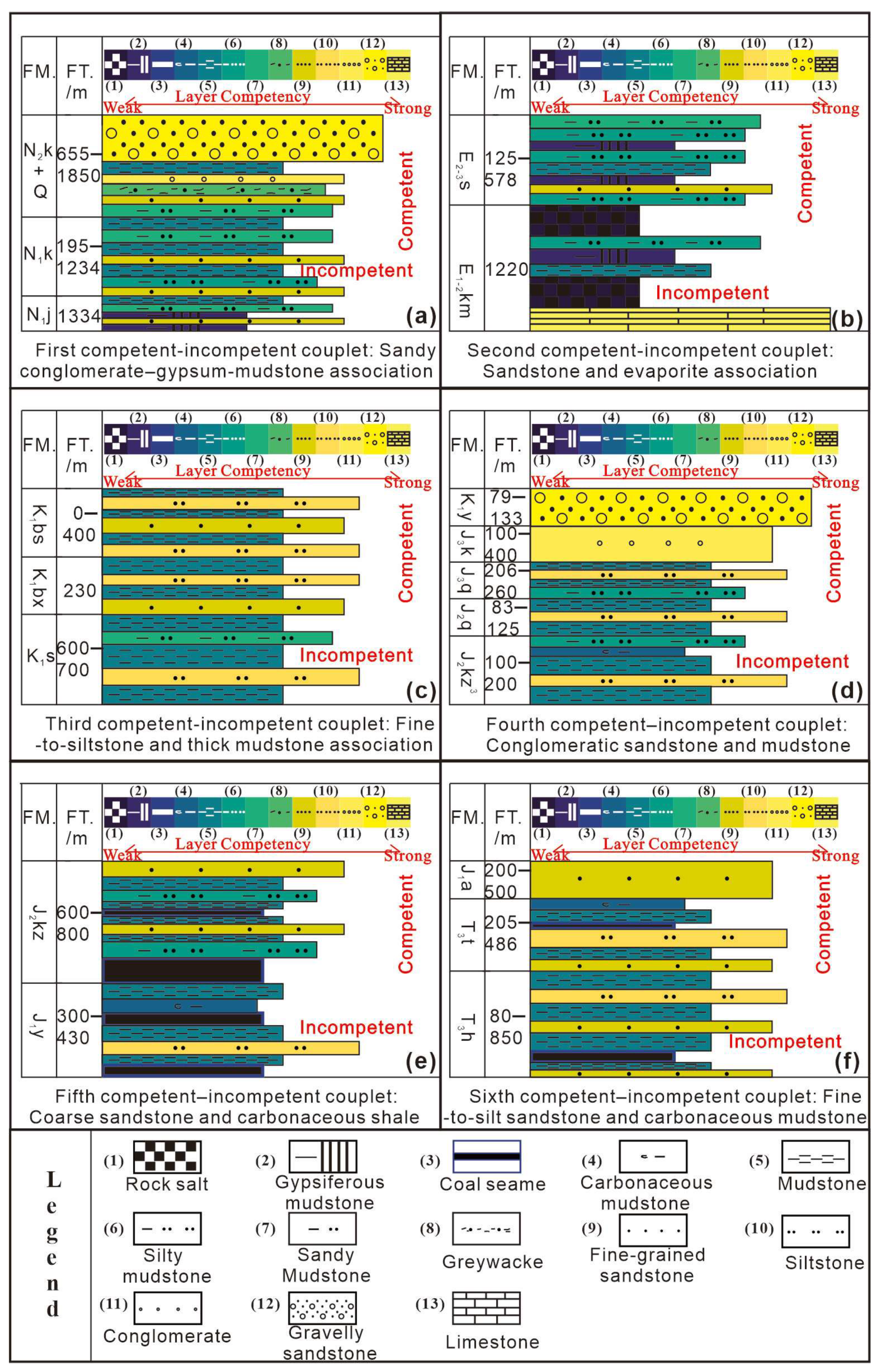
Integrating field observations, seismic interpretations, and well-log data, we propose that the stratigraphic sequence in the Kelasu structural belt exhibits an alternating arrangement of competent and incompetent layers. This sequence can be subdivided into six distinct stratigraphic units characterized by significant contrasts in lithological strength (Figure 8), listed from top to bottom as follows:
- (1)
- Quaternary–Neogene Jidike Formation (Q–N1j): Dominated by gypsum-salt rocks as a strong incompetent layer, interbedded with conglomeratic sandstones and mudstones, forming a conglomeratic sandstone–gypsum-salt–mudstone assemblage (Figure 8a).
- (2)
- Paleogene Kumugeliemu Group–Suweiyi Formation (E2-3s–E1-2km): Characterized by gypsum-salt rocks as a strong incompetent layer, exhibiting greater detachment efficacy than the N1j gypsum-salt. This unit is interbedded with mudstones and sandstones, forming a sandstone–gypsum-salt–mudstone assemblage (Figure 8b).
- (3)
- Cretaceous Bashijiqike–Shushanhe Formations (K1bs–K1s): Features thick mudstone as a coordinative incompetent layer, interbedded with fine sandstones and siltstones, forming a sandstone–thick mudstone assemblage (Figure 8c).
- (4)
- Cretaceous Yagelimu–Jurassic Kezilenuer Formations (K1y–J2kz): Comprises carbonaceous mudstones and mudstones as strong incompetent layers, interbedded with fine sandstones, forming a fine-to-conglomeratic sandstone–mudstone assemblage (Figure 8d).
- (5)
- Jurassic Yangxia–Kezilenuer Formations (J1y–J2kz): Contains carbonaceous mudstones and coal seams as strong incompetent layers, interbedded with fine sandstones and siltstones, with occasional coal stringers, forming a sandstone–siltstone–mudstone–coal assemblage (Figure 8e).
- (6)
- Jurassic Ahe–Triassic Huangshanjie Formations (J1a–T1h): Consists of carbonaceous mudstones and mudstones as strong incompetent layers, interbedded with fine sandstones and siltstones, with coal seams present at the base, forming a conglomeratic sandstone–carbonaceous mudstone–fine sandstone–coal assemblage (Figure 8f).
The regional stratigraphic column in Figure 8 integrates lithostratigraphy and mechanical stratification, with detachment-prone layers (ranks 1–7) highlighted based on their composition of evaporites, coal, and carbonaceous shales.
Collectively, these units establish a “strong–weak–strong–weak–strong–weak” multi-tiered mechanical stratification, which governs the development pattern of the complex, layered ramp–flat multi-detachment model within this salt-bearing foreland thrust belt.
Figure 8.
Stratigraphic columns and layer competency contrasts (competent vs. incompetent layers) of six typical sedimentary sequences in the Kuqa Depression. (a) Sandy conglomerate–gypsum–mudstone association; (b) Sandstone–evaporite association; (c) Fine- to siltstone–thick mudstone association; (d) Conglomeratic sandstone–mudstone association; (e) Coarse sandstone–carbonaceous shale association; (f) Fine- to silt sandstone– carbonaceous mudstone association. FM: Formation abbreviation; FT/m: Formation thickness (m); Layer Competency: Strong (competent) or Weak (incompetent). Horizontal bars indicate stratigraphic intervals with consistent lithology and mechanical behavior.
Ramp–Flat Detachment Fault Architecture Controlled by Contrasts in Rock Mechanical Properties
Contrasts in rock mechanical properties constitute the core of the sub-salt, deep-seated ramp–flat detachment structural model in the Kuqa Depression. According to the Mohr-Coulomb failure criterion (Figure 9) [12,13,14,15,16], when a rock undergoes shear failure, the angle (θ) between the fracture plane and the maximum principal stress axis (σ1) of the Mohr circle is defined as the shear fracture angle. This angle is governed by the rock’s internal friction angle (φ), following the relationship θ = 45° − (φ/2). It can therefore be deduced that a larger internal friction angle (φ) results in a smaller shear fracture angle (θ), leading to a shallower fault dip.
Figure 9.
Mohr circle diagram at shear rupture [12,13,14,15,16].
Consequently, high-angle faults, with dips typically ranging from 25° to 45°, develop within competent layers such as sandstone, carbonate, and granite; these segments form the ramps of the fault system. In contrast, relatively gentle, low-angle faults, with dips commonly between 0° and 35°, develop within incompetent layers, including gypsum-salt rocks, mudstone/shale, and coal-bearing strata; these segments constitute the flats (Figure 10).
Figure 10.
Schematic diagram of the shear Fracture Geometry.
Given the presence of the aforementioned six vertically stacked competent–incompetent layer sequences, the angle at which faults cut across strata varies systematically with the mechanical competency of the host rock. This process ultimately gives rise to the ramp–flat detachment fault architecture, establishing the theoretical foundation for the multi-detachment ramp–flat structural model. This theoretical model has been substantiated by detailed structural interpretations of high-resolution, sub-salt 3D seismic data and has already been applied to guide actual exploration well deployment in oilfields [17,18,19,20].
3.3. Differences Between Multi-Detachment Structures in Salt-Bearing Foreland Thrust Belts and Traditional Thrust Belt Interpretation Models: A Case Study of the Kuqa Depression
Significant differences exist between the ramp–flat multi-detachment model of salt-bearing foreland thrust belts and traditional thrust belt interpretations, primarily reflected in five aspects [21,22,23,24,25]: (1) fault intersection relationships, (2) fault geometry, (3) deformation patterns, (4) trap architecture, and (5) stratigraphic framework. The Kuqa Depression serves as a representative example (Figure 11 and Table 1).
Figure 11.
Contrasting structural evolution in the Tarim Basin’s Kuqa Depression: (a) a classical basement-involved thrust model; (b) a salt- and coal-influenced, multi-level ramp–flat detachment system beneath the evaporite layer, with eight trap types labeled: Trap–1: Subsalt imbricate anticline, Trap–2: Subsalt pop-up anticline, Trap–3: Subsalt triangle-zone anticline, Trap–4: Supra-coal fault-block anticline, Trap–5: Supra-coal fault-bend anticline, Trap–6: Supra-coal pop-up anticline, Trap–7: Sub-coal fault-propagation anticline, Trap–8: Sub-coal thrust-related anticline;.
Table 1.
Comparative analysis of structural interpretation models in the salt-bearing foreland thrust belt of the Tarim Basin.
- (1)
- Fault Intersection Relationships
Traditional models assume a single dominant detachment horizon—typically the Jurassic coal-bearing strata—hosting first-order thrust faults. In contrast, this study identifies multiple regional detachment layers, including gypsum-salt sequences, thick mudstones, coal seams, and even the crystalline basement. Major structures such as the Baicheng and Keshen faults, which control the Kelasu structural belt, root into the gypsum-salt layer at shallow levels and connect downward via ramp–flat secondary faults to a deeper detachment surface. Eastward, these transition into the Dongqiu fault of the Qiulitag belt, where the Triassic coal-bearing strata act as the primary detachment horizon, with late-stage reactivation.
Fault interactions exhibit imbricate and Y-shaped geometries. First-order faults form left-stepping en echelon segments. Third-order back-thrusts commonly sole into second-order faults, facilitated by ductile flow within thick mudstone intervals. Subsalt Mesozoic strata host well-organized pop-up structures. In map view, fault terminations are dominantly arcuate and laterally abut one another or link via strike-slip transfer zones.
- (2)
- Fault Geometry and Spatial Architecture
Traditional interpretations emphasize high-angle, basement-involved thrusts or listric faults. However, the newly proposed subsalt ramp–flat multi-detachment model highlights that the alternating competent (e.g., sandstone, carbonate) and incompetent (e.g., salt, shale, coal) layers control fault dip variation under compression. This results in characteristic ramp–flat fault geometries, where steep ramps in competent units transition to gentle flats within weak layers.
Near the orogenic front and along major transfer zones (e.g., Awate–Bozi, Bozi–Dabei, Dabei–Keshen), high-angle thrusts predominate—consistent with traditional models—due to the influence of pre-existing basement highs, lateral boundaries, and strike-slip faults. Flower structures and fault-related folds are common. Early fault-propagation folds were subsequently breached by late-stage thrusts that propagated to the surface. Overall, the ramp–flat multi-detachment model displays oblique stacking; under intense shortening or limited displacement, it transitions toward vertical stacking.
- (3)
- Deformation Patterns and Zonation
While traditional models established a widely accepted framework of north–south zonation, east–west segmentation, and vertical layering, this study refines the understanding of north–south zonation. We identify an intermediate “ramp–flat multi-tiered detachment transition zone” between the basement-involved thrust belt near the mountain front and the cover-detachment fold belt basinward. This three-stage progressive deformation pattern significantly enhances the classical zonation model.
East–west segmentation remains consistent: from west to east, the Kuqa Depression comprises the Wushi, Awate, Bozi, Dabei, Keshen, Kelar, Dongqiu, Dinan, and Toudong segments. Vertically, the tripartite division—suprasalt, salt, and subsalt layers—is retained. However, the subsalt layer is further subdivided into: (i) the Cretaceous Bashijiqike Formation, (ii) the thick mudstone interval of the Shushanhe Formation, (iii) the coal-bearing strata (Triassic–Jurassic), and (iv) the pre-Mesozoic basement, reflecting the modifying roles of mudstone, coal systems, and paleo-highs.
- (4)
- Trap Architecture and Hydrocarbon Implications
Traditional models focus on fault-bend anticlines within imbricate thrust stacks, forming linear, belt-like trap arrays. In contrast, the ramp–flat multi-detachment model enables systematic classification of traps based on fault hierarchy, clarifying the specific stratigraphic positions of various trap types. We establish interpretive templates for subsalt, coal-related, and coal-interlayer traps, with the subsalt domain comprising two distinct trap sequences: the Cretaceous top and the Cretaceous base.
The Cretaceous top trap sequence primarily consists of the Bashijiqike (K1bs) and Baxigai formations (K1bx), dominated by sandstone and glutenite reservoirs. These high-quality reservoirs, combined with the overlying thick high-pressure to ultra-high-pressure gypsum-salt caprock of the Paleogene Kumugeliemu Group (E1-2km), form an excellent reservoir-cap assemblage. Due to the strong seismic chaotic reflection characteristics of the Kumugeliemu gypsum-salt layer, the Bashijiqike Formation interface is relatively easy to identify, making it the primary target for early shallow subsalt structural trap exploration in the Kuqa Depression. As risk exploration advances toward deeper subsalt levels, the Yageliemu Formation (K1y) has regained attention. Geological understanding has shifted to recognize that the Yageliemu Formation thickens from north to south, with finer sedimentary components and improved reservoir physical properties toward the hydrocarbon generation center, possessing the potential for “finding Kelasu beneath Kelasu.” Consequently, the risk exploration target in the Kuqa Depression has transitioned to the deep Cretaceous Yageliemu Formation.
For coal-related traps, the upper member of the Middle Jurassic Kezilenuer Formation (J2kz), characterized by thick green-gray mudstone interbedded with carbonaceous mudstone, along with the lower black coal seams and the gray mudstone interbedded with thin siltstone of the Qiakemake Formation (J2q), constitute the dominant hydrocarbon source-reservoir system. The thick mudstone sections provide favorable sealing conditions, while the siltstone interbeds and underlying fine sandstone interbeds form the reservoir. Controlled by the coal-bearing detachment layer, this assemblage represents a key target for deep structural trap exploration.
The coal-interlayer and sub-coal trap sequences involve four coal-bearing series: the Middle-Lower Jurassic Kezilenuer (J2kz), Yangxia (J1y), and Ahe formations (J1a), and the Upper Triassic Taleqike Formation (T3t). These coal-bearing strata serve as detachment layers, hydrocarbon source rocks, and reservoir rocks simultaneously, exhibiting self-generation and self-storage as well as lower-generation and upper-storage characteristics. The Upper Jurassic mudstone and carbonaceous mudstone act as caprock, collectively forming two high-quality source-reservoir-cap assemblages for the Middle-Lower Jurassic and Upper Triassic. These sequences represent the key breakthrough targets for future ultra-deep near-source three-dimensional exploration.
Four main trap types are recognized in the subsalt domain: (i) pop-up structures, (ii) imbricate thrust stacks, (iii) triangle zones, and (iv) fault-bend folds. The Cretaceous trap template includes 4 categories and 16 subtypes, while the coal-related template defines 2 categories and 8 subtypes. Map-view configurations are predominantly “fish-scale” style, reflecting complex interference between overlapping fault splays.
- (5)
- Stratigraphic Framework and Model Applicability
Tectonic interpretation in the Kuqa Depression has evolved from fault-related fold theory → salt-tectonics theory → transfer-zone modeling. However, the mechanics of multi-detachment deformation in the subsalt Mesozoic remain debated due to insufficient investigation.
This study integrates structural geology, tectonic analysis, and high-resolution 3D seismic data to delineate Mesozoic deformation styles and propose a subsalt ramp–flat multi-detachment model. The system is controlled by five regionally extensive detachment horizons and characterized by: (i) multi-tiered detachment stacking, (ii) vertically partitioned deformation, and (iii) spatially variable structural superposition.
3.4. Multi-Detachment Deformation Sequence System in the Kuqa Depression
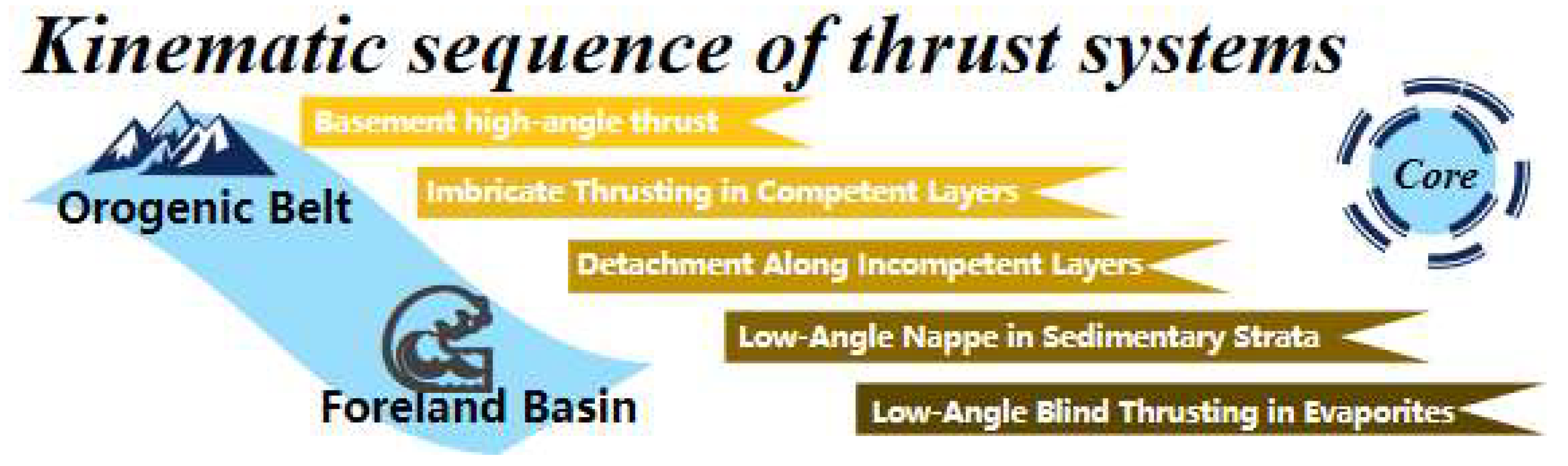
Integrating field outcrop observations, integrated structural physical modeling experiments, and high-resolution seismic data characterizing deep subsalt deformation, this study synthesizes a multi-detachment deformation sequence system for the subsalt Kuqa Depression (Figure 12), which can be subdivided into five sequential components:
- (1)
- In the vicinity of the South Tianshan orogenic belt, first-order master detachment faults predominantly develop as high-angle, basement-involved thrust structures.
- (2)
- As these faults propagate basinward into deeper sedimentary strata, their dip angles gradually decrease.
- (3)
- Upon reaching the Triassic and Jurassic coal-bearing intervals, fault dips further reduce, with localized bedding-parallel detachment occurring; these detachment faults exhibit moderate to long-distance displacement.
- (4)
- The faults then ramp upward into the Jurassic–Cretaceous sandstone units, where dip angles increase again, forming a characteristic “ramp–flat–ramp” fault geometry and generating imbricate thrust stacks within competent layers.
- (5)
- Finally, the faults root upward into the gypsum-salt layer, where variations in salt thickness lead to localized differences in subsalt structural deformation across different segments.
Figure 12.
Schematic Diagram of the Sub-Salt Multi-Detachment Structural Deformation Sequence in the Kuqa Depression.
3.5. Basis for the Structural Evolution Restoration Cross-Section of the Kuqa Depression
3.5.1. Awate–Bozi (West) Segment
During deposition of the Paleogene Suweiyi Formation in the Awate–Bozixi segment (Figure 13), strata near the orogenic belt remained nearly horizontal, gradually thinning toward the basin interior, exhibiting an overall wedge-shaped geometry. Pre-existing basement faults were active in the basement high and slope zones. The shortening distance between the South Tianshan Orogen and the Wensu Paleohigh was relatively narrow, resulting in limited space for compressional deformation. The basin was dominated by differential subsidence, leading to the development of multiple secondary depocenters. At this stage, the stress regime was characterized by intracontinental weak extensional sagging, and no thrust faults had yet developed near the orogenic belt.
Figure 13.
Balanced structural cross-section of the Awate–Bozi West segment (Profile locations shown in Figure 1).
During deposition of the Neogene Jidike Formation, a first-order (I-level) detachment fault initiated near the orogenic belt, and a second-order (II-level) detachment fault developed at the distal end of the I-level fault’s flat segment, stacking above the I-level fault. This period was marked by retroforeland reactivation. Under compressional stress, minor fault-related folds formed in the hanging wall of the detachment system.
During deposition of the Neogene Kangcun Formation, an intracontinental foreland basin became dominant. Detachment faults along the compressional margin began to develop in organized, parallel thrust belts, and compressional intensity progressively increased. The spatial arrangement of wedge-shaped structural units transitioned from sub-horizontal to oblique imbrication, marking the initial emergence of a single wedge-type imbricate thrust system. Multi-level detachment faults propagated upward and rooted into the gypsum-salt layer, while the overlying Cenozoic strata developed gentle folds.
During deposition of the Neogene Kuche Formation, the remote effects of the India–Eurasia plate collision induced intense compression, significantly intensifying structural complexity near the orogenic belt. A third-order (III-level) fault developed at the ramp–flat transition zone of the II-level detachment fault, stacking above it and forming a pop-up structure. In areas where multi-level detachments overlapped, stratigraphic thickness increased markedly, and strain decoupling across detachment levels intensified. The ramp–flat geometry of the fault system became more pronounced. Frontal detachment faults associated with fold forelimbs cut downward through the gypsum-salt layer and propagated upward, breaching the surface locally and generating salt piercement structures. Strata near the orogenic belt exhibited significant tilting. The increasing number and intensification of Mesozoic fold geometries accommodated the growing shortening strain. Above the salt layer, large-scale composite synclinal structures developed in the supra-salt sequence.
3.5.2. Bozi Segment
During deposition of the Kumugelie Formation (Figure 14), the narrow, elongate NWW–NE-trending spatial configuration of the Qiulitag Paleohigh controlled basin architecture. The relatively large distance between the South Tianshan Orogen and the high-amplitude western Qiulitag Paleohigh provided ample space for compressional deformation. Consequently, the overall thrust-sheet system exhibited a long detachment displacement. Near the orogenic belt, high-angle basement-involved thrust faults predominated, whereas the paleohigh slope zone displayed cover-detachment-style deformation. These structures are rooted upward into the gypsum-salt layer and downward into the coal-bearing Kezilenuer Formation (Jurassic), producing only gentle folding and maintaining an overall gently depositional geometry.
Figure 14.
Balanced structural cross-section of the Bozi segment (Profile locations shown in Figure 1).
During Neogene Jidike Formation deposition, multiple parallel belts of basement-involved thrust faults developed near the compressional margin, primarily generating fault-bend folds and forming embryonic fault-related anticlinal traps. A frontal detachment fault also initiated, detaching downward into the gypsum-salt layer, causing strata to transition from near-horizontal to low-amplitude, low-angle folds.
During Kangcun Formation deposition, intense uplift reactivated pre-existing basement faults, triggering highly complex deformation and establishing a classic double-wedge imbricate thrust system. Multiple second-order (II-level) ramp–flat detachment faults linked downward to the first-order (I-level) Baicheng master detachment (the basal décollement), forming the lower structural wedge. Meanwhile, the I-level Bozi–Kela fault acted as the roof décollement of the upper structural wedge. Locally, duplex structures developed. The upper wedge was largely emplaced into the gypsum-salt layer, significantly modifying its geometry and locally generating salt pillows and salt piercements. This established the fundamental I- and II-level detachment framework of the double-wedge system. At this stage, the upper and lower wedges were sub-horizontally arranged with a relatively wide separation, and overall folding intensity increased. The supra-salt sequence locally exhibited syndepositional structural growth features.
During Kuche Formation deposition, intense late Himalayan compression finalized the development of a multi-level, ramp–flat detachment system. Strata near the compressional front underwent strong folding, with some sequences even overturned. The spatial relationship between the upper and lower wedges transitioned from sub-horizontal to oblique imbrication, with reduced inter-wedge distance. Third-order (III-level) detachment faults further developed. Gypsum-salt layers exhibited enhanced ductile flow, resulting in pronounced thickness variations and localized salt welds. The entire double-wedge system became significantly tilted, ultimately establishing a complex multi-detachment structural framework beneath the salt layer.
3.5.3. Dabei Segment
During deposition of the Neogene Jidike Formation (Figure 15), the distance between the South Tianshan Orogen and the low-amplitude eastern Qiulitag Paleohigh was relatively large. The wedge-shaped sedimentary package thickened toward the orogenic front and progressively thinned basinward, with strata remaining nearly horizontal. The deformation style still exhibited a clear zonation, characterized by cover detachment in the basin interior and basement-involved thrusting proximal to the mountain front.
Figure 15.
Balanced structural cross-section of the Dabei segment (Profile locations shown in Figure 1).
During the subsequent Kangcun and Kuche Formation depositional stages, the Dabei segment experienced complex structural evolution driven by: (1) lateral variations in gypsum-salt layer thickness and its evolving decoupling behavior; (2) the west-to-east transition in paleohigh amplitude (from high to low) across the Qiulitag uplift; and (3) superposition of multiple tectonic events. These factors collectively promoted the development of a structural transfer zone between the Bozi and Dabei segments. Volumetric strain in the Dabei segment localized near this paleohigh transfer zone. The consequent stress release shortened the effective stress propagation distance, resulting in relatively mild deformation in the supra-salt sequence and the formation of broad, gentle folds. In contrast, near the compressional front, vertical stacking of strata intensified dramatically, although fault slip distances remained limited. The I- and II-level detachment systems developed at low dips, and the spacing between individual imbricate slices within the sub-salt multi-detachment imbricate fan was relatively wide, leading to generally subdued inter-slice deformation. This setting facilitated the nucleation of III-level detachment faults.
Balanced cross-section restorations for the Awate–Bozixi, Bozi, and Dabei segments consistently demonstrate that the Kelasu Structural Belt of the Kuqa Depression is characterized by a superposition of detachment and thrust-fold structures. The Mesozoic strata beneath the salt layer exhibit favorable conditions for the development of en echelon secondary anticlinal traps, indicating significant hydrocarbon exploration potential.
3.6. A Theoretical Model of Subsalt Ramp–Flat Multi-Detachment Tectonics in Salt-Bearing Foreland Thrust Belts: A Case Study from the Kelasu Structural Belt, Kuqa Depression
In summary, integrating field outcrop observations, rock mechanical property contrasts governed by competent–incompetent layering, structural interpretations of representative seismic framework profiles, and balanced cross-section restorations, a subsalt ramp–flat multi-detachment model has been established (Figure 16). Its core elements can be summarized as follows.
Figure 16.
A stacked multi-level detachment system controlled by rheological contrasts in the Kuqa Foreland Thrust Belt, Tarim Basin. Key detachment levels include: (1) basement detachment; (2) coal-seam décollement; (3) shale- and evaporite-linked secondary detachments. (4) Class I-II-III faults reflect progressive deformation from flat-ramp transitions to pop-up structures.
(1) High-angle thrust faults initiate within the basement; (2) Upon entering the sedimentary cover, the primary (Level I) detachment fault progressively flattens its dip; (3) Within coal-bearing strata, the Level I detachment undergoes long-distance displacement along weak coal seams, with localized intraformational detachment also observed; (4) Basement-involved detachment occurs along pre-existing paleohighs; (5) Fault-bend folds predominantly develop above the flat segments of detachment faults; (6) Level III faults nucleate at the ramp–flat transition zones of the main detachment; (7) Level III faults, facilitated by ductile deformation within thick mudstone layers, back-thrust onto Level II faults, forming pop-up structures; (8) Level II faults originate at the trailing edges of the Level I ramp segments; and (9) Level II faults exhibit a characteristic ramp–flat geometry, with fault dips displaying a steep–shallow–steep variation.
The complex, layered detachment system—controlled by multiple décollements including the pre-existing basement paleohigh, gypsum-salt layers, thick mudstones, and coal-bearing strata—is the key factor governing the effectiveness of hydrocarbon accumulation in ultra-deep reservoirs. Under the control of this ramp–flat multi-detachment model, three primary trap types can be delineated: (1) pop-up structural traps; (2) imbricate fault-propagation anticline traps; and (3) triangle zone traps.
This model has been successfully applied to well-site selection and real-time drilling support for four wells (DB32, DB4, BT1, and YG2) in the Kelasu Structural Belt, and has directly contributed to the discovery of seven exploration prospects: BZ5, BZ27, BZ33, BZ35, DB26, DB32, and DB34.
It should be noted that the seismic identification of ramp–flat geometries in this study follows well-established criteria from prior regional work, which has systematically classified ten distinct detachment structural styles across the Kuqa Depression and compiled a comprehensive atlas of diagnostic seismic facies for each type [18]. That study explicitly evaluated spatial variations in interpretational uncertainty associated with ramp–flat versus linear geometries and provides reference models for key features observed here—including imbricate and Y-shaped fault junctions, left-stepping arrangements of first-order thrusts, and fish-scale trap configurations. Our interpretation adheres to these validated seismic pattern templates, thereby anchoring our geometric inferences in a regionally consistent and uncertainty-informed framework.
3.7. Segmented Framework Cross-Section Scheme of the Kelasu Structural Belt, Kuqa Depression: Insights from Ramp–Flat Multi-Detachment Tectonic Analysis
The Kuqa Depression can be broadly divided along the east–west direction into three structural domains: the western Wushi Sag, the central Baicheng Sag, and the eastern Yangxia Sag. The Wushi–Baicheng–Yangxia depression system is further subdivided into eight tectonic segments: Wushi, Awate, Bozi, Dabei, Keshen, Zhongqiu–Dongqiu, Dibei, and Toudong. Based on a seismic facies template for subsalt detachment structures and applying the ramp–flat multi-detachment tectonic interpretation model, this study conducts a detailed structural analysis of complex segments within representative 3D seismic framework cross-sections across the Bozi–Dabei–Keshen transect. The aims are to further validate the applicability of this tectonic model in interpreting ultra-deep subsalt structures and to investigate how multi-order detachment faults—and their potential controlling factors throughout tectonic evolution—influence the deep deformation styles beneath the salt in each segment, thereby providing a conceptual basis for future physical analogue modeling experiments incorporating multiple controlling variables.
3.7.1. Western Bozi Segment
The Bozi–Dabei segments are primarily controlled by the macroscopic geometry of pre-existing basement paleohighs, with the intervening inter-high zone acting as a structural transfer zone that separates the two segments.
In the western Bozi segment, Paleogene salt layers impose strong mechanical decoupling: above the salt, large-scale faults nucleating at the salt level generate major thrusts and broad folds; below the salt, early-formed Level I faults are reactivated, Level II faults develop imbricate thrust stacks, and Level III faults provide local adjustments, resulting in highly complex deformation. Thrust-dominated structures prevail, with localized detachment along Level I faults. Early basement-involved faults defined the original rift-basin margins. In the deep subsalt domain, the spacing between Level I faults is characterized by ramp–flat-style detachment–thrust imbricate fans. The short propagation distance of these detachments produces deformation patterns analogous to those formed under spatially restricted compressional settings (Figure 17).
Figure 17.
Geological Interpretation Profile across Wells YZ2-JM1-AW5 (Profile locations shown in Figure 1).
3.7.2. Central Bozi Segment
In the central Bozi segment, the supra-salt structural layer is relatively simple. The Neogene strata exhibit syndepositional deformation features, and the Quaternary deposits are in angular unconformity with the underlying units. The northern limb of the syncline is arched upward, displaying onlap unconformity, with marked thickness asymmetry across the structure. The northern slope of the paleohigh is gentle. Level I faults originate from basement detachment and are concealed within the Jurassic–Triassic coal-bearing strata, clearly manifesting a multi-level detachment architecture. Subsalt structures are dominated by fault-bend and fault-propagation anticlinal traps (Figure 18).
Figure 18.
Geological Interpretation Profile across Wells YZ1-BZ3 in the Central Segment of the Kuqa Depression (Profile locations shown in Figure 1).
3.7.3. Eastern Bozi Segment
In the eastern Bozi segment, the Neogene succession shows significant thickness contrast between the piedmont and depocenter areas. In the basement-involved thrust zone, gypsum-salt layers are notably thick. The northern slope of the supra-salt syncline exhibits two distinct uplifted arches, with paleohigh intensity progressively decreasing from north to south. The thrust–detachment wedge displays an overall flattened geometry, and fault propagation distances are extensive. Since the Miocene, frontal thrusting has progressively advanced basinward, and the subsalt, foreland-propagating detachment deformation weakens southward. The Triassic interval is characterized by blind fault-propagation folds, while imbricate thrust stacks within the Jurassic are primarily developed at the flats of Level II faults. Level III faults modify hydrocarbon traps via ramp segments (Figure 19).
Figure 19.
Geological Interpretation Profile across Well BZ1801 in the Eastern Segment of the Kuqa Depression (Profile locations shown in Figure 1).
3.7.4. Western Dabei Segment
In the western Dabei segment, the supra-salt structural layer commonly develops fault-related folds, with localized Y-shaped pop-up structures. The gypsum-salt layer undergoes intense deformation. Subsalt, a duplex-style imbricate thrust system is developed, accompanied by pop-up structures. Within the coal-bearing strata, imbricate thrust stacks involving coal seams are observed; coal seams are locally thickened in zones where duplex thrust sheets vertically overlap. Beneath the coal measures, the basement-involved structural layer exhibits back-thrust geometries (Figure 20). The Mesozoic succession as a whole displays coaxial deformation: from the South Tianshan orogen toward the Tarim Basin, the structural style transitions obliquely from basement-involved thrusting to wedge-shaped imbricate thrusting, onlapping onto the paleohigh of the western Qiulitag tectonic belt.
Figure 20.
Geological Interpretation Profile across Wells YT1-DW1-DB1 in the Western Segment of the Kuqa Depression (Profile locations shown in Figure 1).
3.7.5. Central Dabei Segment
The central Dabei segment is characterized by weak thrusting but strong detachment (Figure 21). The spatial extent and thickness variation in regional detachment horizons control the vertical partitioning and decoupled deformation of structural layers. Meanwhile, the geometry of the underlying paleohigh and its distance from the South Tianshan orogen govern the degree of structural superposition and deformation intensity.
Figure 21.
Geological Interpretation Profile across Well DB11 in the Central Segment of the Kuqa Depression (Profile locations shown in Figure 1).
3.7.6. Eastern Dabei Segment
In the eastern Dabei segment, the Miocene and Pliocene successions exhibit pronounced thickness contrasts, and supra-salt anticlines display significant structural relief. The piedmont zone resembles a piggyback-style foreland basin, featuring a large syncline. Pop-up structures controlled by Level I faults in the footwall dominate trap development. The stronger the thrust displacement, the larger the pop-up structure—thus, pop-up size progressively diminishes from the orogen toward the basin interior. The frontal zone is dominated by imbricate fault-propagation anticlines with relatively small pop-up features. Detachment within the coal measures controls overlying fault-bend anticlines, whereas basement detachment governs fault-bend and fault-propagation anticlines within the coal-bearing strata themselves (Figure 22).
Figure 22.
Geological Interpretation Profile across Wells QT1-DB3 in the Eastern Segment of the Kuqa Depression (Profile locations shown in Figure 1).
3.7.7. Western Keshen Segment
In the western Keshen segment, the degree of subsalt uplift and the scale of thrust structures control the development of pop-up anticlines, which exhibit high structural relief and extensive detachment propagation distances. The footwall detachment fault governs the horizontal propagation distance; the gentler the dip of the paleohigh basement, the farther the forward propagation of the detachment, commonly resulting in fault-bend and fault-propagation folds (Figure 23).
Figure 23.
Geological Interpretation Profile across Well KS131 in the Western Segment of the Kuqa Depression (Profile locations shown in Figure 1).
3.7.8. Eastern Keshen Segment
Structural analyses of deep subsalt ramp–flat multi-detachment models in the eastern Keshen segment reveal a ramp–flat-style transitional zone characterized by multi-level detachment stacking, situated between the wedge-thrust imbricate belt and the basement-involved thrust belt. Based on variations in deformation style and stress field gradients, the Kuqa foreland thrust belt is subdivided from south to north into three structural domains: the piedmont thrust sheet, the basin–orogen transition zone, and the frontal basin interior deformation zone. These correspond respectively to the three northward-facing anticlinal belts at the mountain front: the first anticlinal belt (northern monocline) lies in the hanging wall of a major thrust fault adjacent to the South Tianshan; the second aligns with the Kelasu–Yiqikelike structural belt; and the third coincides with the Qiulitag structural belt. The orogenic, slope, and uplift zones thus correspond to basement-involved thrusting, multi-level detachment stacking, and wedge-thrust imbricate structures in the frontal uplift zone, respectively.
Deformation above and below the gypsum-salt detachment horizon is decoupled, exhibiting distinct layer-parallel partitioning. Near the contractional tip, thrusting dominates, accompanied by fault-related folding. Early-stage fault-propagation folds are subsequently breached by forward breakthrough, forming listric forward-breaking thrusts that are steep at the surface and flatten downward, ultimately piercing through to the surface. From the orogen toward the basin, the subsalt sequence transitions from high-angle basement-involved faults to an imbricate thrust fan, and finally to cover detachment, with localized positive flower structures indicating strike-slip components. The Dongqiu Fault at the base of the Triassic serves as the basal detachment surface. The Keshen Fault detaches along the thick mudstone of the Lower Cretaceous Shushanhe Formation and the underlying Triassic coal seams, within which internal drag folding may occur. In the frontal zone near the orogenic contractional tip, high-angle basement-involved faults in the pre-coal basement cut downward through the coal measures into the Mesozoic strata and upward terminate beneath the gypsum-salt layer, exhibiting large displacements (Figure 24).
Figure 24.
Geological Interpretation Profile across Wells KS604-M1 in the Eastern Segment of the Kuqa Depression (Profile locations shown in Figure 1).
4. Discussion
4.1. Controlling Factors of Subsalt Ramp–Flat Multi-Detachment Deformation
This study, using the Kuqa Depression as a case example, identifies five primary factors governing the complex multi-detachment architecture and hierarchical faulting (first- to third-order faults) in salt-bearing foreland thrust belts: (i) paleohigh geometry, (ii) spatial configuration of compressive stress, (iii) basin-bounding faults, (iv) stress regime orientation, and (v) rheological contrasts among detachment layers.
Our proposed subsalt ramp–flat multi-detachment model represents a significant refinement over previous interpretations for the Kuqa Depression, which were largely based on either basement-involved thrust models or simple single-detachment thin-skinned tectonics. The key novelty lies in the explicit recognition of multiple, interacting regional detachment horizons—including gypsum-salt, mudstone, and coal—that collectively partition the deformation into distinct vertical tiers, each with its own kinematic style and trap-forming potential.
Among these, the gypsum-salt sequence serves as the dominant detachment horizon within the multi-detachment system due to its pronounced ductile flow behavior, exhibiting significant lateral variations in thickness and distribution. This variation exerts a decisive control on the development of salt-related structures and their mechanical coupling/decoupling with the underlying strata. Specifically, in areas where the overlying gypsum-salt layer is relatively thin, insufficient salt supply restricts the full evolution of salt diapirs or pillows, resulting in weaker vertical decoupling between the supra and sub-salt levels. Consequently, deep-seated thrust faults can penetrate through the salt layer, directly influencing the surface morphology. Conversely, where the gypsum-salt layer is thick, strong vertical partitioning effectively segregates the deformation, leading to the development of bedding-parallel detachments and thrusts in the sub-salt sequence, while the supra-salt cover forms an independent structural assemblage governed by salt flow, collectively manifesting as a clear layered deformation pattern.
These controls manifest distinctly across segments. In the Bozi–Dabei segment, the distance between the frontal paleohigh and the main compressive front controls the vertical decoupling of deformation, resulting in distinct layered fold–thrust systems above and below salt. In the Dabei–Keshen segment, a major basin-margin fault controls along-strike structural reorientation; oblique compression generates en echelon strike-slip fault arrays, and subsequent transpressional modification promotes the formation of pop-up traps. The Dongqiu segment exhibits a left-lateral, right-stepping fault system, where newly formed “S”-shaped faults intersect pre-existing structures at an oblique angle, producing en echelon trap distributions. In the Toudong segment, NE–N–S trending strike-slip faults crosscut E–W trending thrusts, disrupting original anticlinal geometries but potentially serving as hydrocarbon migration pathways.
To elucidate the dynamic role of late-stage strike-slip deformation—particularly its capacity to both disrupt and generate traps—we conducted analog modeling of transpressional tectonics in the Dabei–Dongqiu segment. The experimental results (Figure 25) reveal a progressive evolution, which is quantitatively constrained by Particle Image Velocimetry (PIV) analysis (Figure 26 and Figure 27). The simple shear rate maps, combined with displacement vectors, illustrate the full process of strain localization and partitioning during transpressional strike-slip modification.
Figure 25.
Plan view of analog model simulating transpressional strike-slip deformation. Red lines denote planar faults; blue lines specifically indicate late-stage strike-slip faults that overprinted earlier structures and played a key role in trap reconfiguration.
Figure 26.
Cross-section of analog model illustrating transpressional strike-slip modification.
Figure 27.
PIV analysis of the simple shear rate evolution during the transpressional strike-slip modification. The maps illustrate the deformation process of the analog model at shortening stages of 5%, 15%, 31%, and 46%. Color contours represent the simple shear rate, while black vectors indicate the relative displacement direction.
At the initial shortening stage (5%), deformation is dominated by uniform contraction, with low and evenly distributed simple shear rates across the model (Figure 27). Only minor, isolated shear perturbations appear at the model’s leading edge, indicating that strain remains broadly distributed rather than localized. Under pure contraction at 15% shortening, NW–SE trending imbricate thrusts develop, forming belt-like anticlinal traps analogous to early-stage structures in the Dabei area. The corresponding PIV map highlights the onset of strain partitioning: discrete zones of high simple shear intensity begin to cut across the earlier contractional fabric, marking the initial localization of deformation and the transition to transpressional conditions.
As shortening increases to 31% and lateral shear displacement accumulates, Riedel shears emerge and link into en echelon strike-slip faults. The PIV results clearly show a progressive concentration of high simple shear rates along these newly formed shear zones, with strain shifting from a diffuse contractional pattern to localized transpressional shear. At the advanced stage of 46% shortening, the PIV-derived simple shear rate map visualizes the full maturity of the transpressional system: high shear rates are strongly concentrated along a well-defined main strike-slip zone, which exhibits a braided internal architecture and horse-tail terminations. This pattern closely matches the observed “S” -shaped, left-lateral, right-stepping fault system in the Dongqiu segment, confirming the efficiency of strain localization within the developing flower structure.
Critically, this transpressional overprint does not merely degrade pre-existing closures; it actively reconfigures trap architecture by partitioning strain between contractional and strike-slip domains. New pop-up and flower-structure traps form within the strike-slip corridor (Figure 26), while fault cores, marked by the highest simple shear rates in the PIV analysis, provide efficient vertical migration conduits. This mechanism explains the complex interference patterns and pervasive “fish-scale” map-view geometries observed across the Kuqa foreland.
4.2. Implications for Trap Types in Ultra-Deep Hydrocarbon Exploration
These five factors collectively determine the geometry and spatial distribution of ultra-deep subsalt traps. In the Bozi–Dabei area, the macro-morphology of the paleohigh acts as the first-order control, with the intervening transfer zone separating two distinct domains. Both sides develop arcuate, imbricate fan-like structures that host en echelon anticlinal trap belts. Trap morphology is further modulated by fault dip angles and lithological heterogeneities. In the western Zhongqiu sub-basin, extensive detachment propagation—facilitated by weak coal- and salt-bearing horizons—enables the development of stacked closures both above and below coal-related detachments, forming compound trap clusters involving multiple first- to third-order faults. In contrast, limited detachment propagation in the eastern Zhongqiu results in widely spaced, gently folded anticlines dominated by first-order imbricate thrusts. Notably, the Kuqa Depression experienced late-stage hydrocarbon charging, which is temporally consistent with the final phase of secondary structural adjustment, suggesting a genetic link between trap preservation and late tectonic reactivation (Figure 28).
Figure 28.
Geological interpretation of 3D structural segmentation, transfer zones, and lateral variation in deformation styles in the Kuqa Foreland Fold-and-Thrust Belt, showing high consistency with tectonic physical simulation results.
4.3. Limitations and Future Research Directions
Although this study establishes an integrated framework for structure-controlled trapping using the Kuqa Depression as a key case study, its implications extend far beyond this specific region, offering a valuable reference paradigm for exploring complex ultra-deep targets within salt-bearing foreland fold–thrust belts globally. Nevertheless, several critical areas warrant further investigation to deepen our understanding of the shared evolutionary dynamics of such systems:
- (1)
- Integration of digital outcrop and subsurface data: Future research should integrate high-precision digital outcrop modeling techniques with subsurface seismic interpretations to establish a unified “surface–subsurface” validation methodology. Coupling this approach with 3D balanced cross-section restoration will enable reconstruction of the overall tectonic architecture in key segments of the Kuqa Depression, thereby providing deeper insights into the coupling mechanisms between regional sedimentation and tectonic evolution.
- (2)
- Quantitative characterization of weak layers: Our current understanding of how the specific properties of detachment horizons—including their spatial distribution, thickness, lateral extent, and geometric variability—govern deformation processes remains insufficient. Future work should focus on the mechanical coupling mechanisms among multiple detachment levels. The combined application of physical analog modeling and numerical simulations will allow for rigorous quantitative assessments of how rheological contrasts between these weak layers control trap geometry and spatial distribution.
- (3)
- Migration of paleohighs and structural culminations: During foreland basin evolution, the migration of frontal paleohighs occurs synchronously with orogenic activity. The dynamic interplay among paleohigh migration, the accommodating role of thick mudstone detachment layers, and the migration of structural culminations is critically important but remains inadequately studied. It is recommended that high-resolution sequence stratigraphic methods be employed to systematically decipher the migration patterns of frontal paleohighs. A thorough understanding of this process is key to predicting the spatiotemporal evolution of structural highs and will significantly enhance the success rate of discovering ancient hydrocarbon accumulation systems.
- (4)
- Validation of deep-seated trap distribution patterns: Integrated evidence from field geological outcrop surveys, detailed structural analyses, physical analog modeling experiments, and structural evolution restorations collectively indicates the potential existence of secondary anticlinal traps arranged in en echelon or linear arrays within the ultra-deep subsalt domain. Future structural modeling studies should focus on the sequential development and geometric relationships of multi-order faults under ultra-deep geological conditions and multi-detachment control. Validating the rationality of these deep trap distribution models through forward and inverse modeling approaches will be crucial for optimizing the deployment of future exploration targets.
5. Conclusions
This study integrates field geological investigations of Mesozoic subsalt outcrops along the southern flank of the Tianshan Mountains, ultra-deep structural analyses in the Bozi–Dabei segment, analog modeling experiments, and 2D balanced cross-section restorations to establish a ramp–flat multi-detachment model for the Kuqa Depression. Key advances include the following:
- (1)
- A ramp–flat multi-detachment model is proposed, which induces fault dip variations during rupture. Based on this model, six representative interpretation schemes for subsalt multi-detachment deformation in the Kuqa Depression are developed. This model significantly differs from previously established thrust interpretations in five aspects: (i) connectivity between first- and second-order faults, (ii) fault geometry, (iii) structural zonation, (iv) deformation styles and their trap-controlling roles, and (v) overall basin architecture.
- (2)
- The stratified structural framework of the Kuqa Depression is refined: beyond the well-known salt detachment, multiple subsalt horizons—including the Cretaceous Bashijiqike Formation and underlying strata—are recognized as potential detachment levels. Four regional detachment layers control foreland deformation: (i) gypsum-salt, (ii) thick mudstone, (iii) coal-bearing strata, and (iv) basement. Vertically, the basin is subdivided into six tectonic units: supra-salt, salt, subsalt, supra-coal, coal, and sub-coal basement.
- (3)
- A previously unrecognized structural zone—the ramp–flat multi-detachment overlap belt—is identified between the basement-involved thrust belt and the cover décollement belt, refining the classical two-fold zonation of foreland deformation.
- (4)
- Analog modeling reveals that subsalt multi-detachment deformation is governed by five key factors: (i) paleohigh geometry, (ii) distance from the South Tianshan orogenic front, (iii) basin-bounding faults, (iv) regional stress orientation, and (v) rheological contrasts among detachment layers—consistent with findings from structural and seismic analyses.
- (5)
- Ultra-deep traps, controlled by multi-order detachment systems and lithological competence contrasts, are distributed across three primary closure levels: subsalt, supra-coal, and sub-coal. Six trap types are identified: pop-up anticlines, imbricate thrust-related anticlines, structural triangle zones, fault-bend folds, supra-coal anticlines, and inter-/sub-coal anticlines. Among these, structural triangle zones—characteristic of the ramp–flat multi-detachment model—represent high-priority targets for integrated, full-stratigraphic exploration in ultra-deep settings.
- (6)
- As a representative case of salt-bearing foreland thrust belts with ultra-deep targets, the Kuqa Depression demonstrates how multi-detachment architectures governed by rheological stratification and tectonic boundary conditions can generate complex yet predictable trap systems. The ramp–flat multi-detachment model and its associated control framework established in this study offer a transferable paradigm for hydrocarbon exploration in analogous settings worldwide.
Author Contributions
Y.M. and J.Z. conceived the idea and designed the framework. J.Z., Y.N. and W.W. collected data and identified structural evidence; K.X. and H.X. performed physical simulations; Y.W. and P.L. analyzed seismic data. Y.M. wrote the draft, and all authors reviewed and edited the manuscript. All authors have read and agreed to the published version of the manuscript.
Funding
This research was jointly supported by the National Science and Technology Major Project (2025ZD1402401), the National Natural Science Foundation of China (42362026), and the Xinjiang Key Research and Development Program (2024B01015).
Data Availability Statement
The data that support the findings of this study are not openly available due to restrictions from the data provider (Tarim Oilfield Company). Derived data (e.g., interpreted structural maps, simulation parameters) are available from the corresponding author upon reasonable request.
Acknowledgments
The authors have reviewed and edited the output and take full responsibility for the content of this publication.
Conflicts of Interest
The authors declare no conflicts of interest.
References
- Wang, Q.H.; Yang, H.J.; Yang, W. New progress and future exploration targets in petroleum geological research of ultra-deep clastic rocks in Kuqa Depression, Tarim Basin, NW China. Pet. Explor. Dev. 2019, 52, 70–83. [Google Scholar] [CrossRef] [Scilit]
- Lai, J.; Li, D.; Bai, T. Reservoir quality evaluation and prediction in ultra-deep tight sandstones in the Kuqa depression. J. Struct. Geol. 2023, 170, 104850. [Google Scholar] [CrossRef] [Scilit]
- Xu, K.; Zhang, H.; Ning, W. Geomechanical parameter-driven evaluation of ultra-deep reservoirs: An integrated methodology and its application to the Kuqa depression, Tarim basin. Energy Geosci. 2025, 6, 100433. [Google Scholar] [CrossRef] [Scilit]
- Ju, W.; Zhong, Y.; Liang, Y. Factors influencing fault-propagation folding in the Kuqa Depression: Insights from geomechanical models. J. Struct. Geol. 2023, 168, 104826. [Google Scholar] [CrossRef] [Scilit]
- Jiang, F.; Chen, X.; Wang, P. Genesis and accumulation of paleo-oil reservoir in Dabei Area, Kuqa Depression, Northwest China: Implications for tight-gas accumulation. J. Earth Sci. 2024, 35, 655–665. [Google Scholar] [CrossRef] [Scilit]
- Xu, K.; Yang, H.; Zhang, H. Fracture effectiveness evaluation in ultra-deep reservoirs based on geomechanical method, Kuqa Depression, Tarim Basin, NW China. J. Pet. Sci. Eng. 2022, 215, 110604. [Google Scholar] [CrossRef] [Scilit]
- Luo, L.; Guo, J.; Hu, C. Sedimentary characteristics and development model of the bedded evaporites in the Paleogene Kumugeliemu formation, Kuqa depression, Northwestern China. Carbonates Evaporites 2024, 39, 68. [Google Scholar] [CrossRef] [Scilit]
- Li, J.; Wang, R.; Qin, S. Evolution of Mesozoic paleo-uplifts and differential control on sedimentation on the southern margin of Kuqa Depression, Tarim Basin. Mar. Pet. Geol. 2024, 161, 106707. [Google Scholar] [CrossRef] [Scilit]
- Yang, K.; Qi, J.; Shen, F. Formation mechanism of salt piercement structures in a compressive environment: An example from the Kuqa Depression, western China. J. Struct. Geol. 2024, 178, 105005. [Google Scholar] [CrossRef] [Scilit]
- Zhang, Z.; Tang, P.; Sun, J. Chronology, structures and salt tectonics in the northern Kuqa Depression, NW China: Implications for the Cenozoic uplift of Tian Shan and foreland deformation. Glob. Planet. Change 2024, 243, 104618. [Google Scholar] [CrossRef] [Scilit]
- Chen, W.L.; Mo, T.; Hu, C.L. Analogue modeling of sub-salt tectonic deformation controlled by paleo-uplifts in foreland basins: A case study of the Bozi-Dabei area in the Kuqa Depression. Deep Earth Energy Sci. Technol. 2023, 20, 1885–1898. [Google Scholar]
- Li, Z.; Li, H.; Zhang, Q. A Modified Nonlinear Mohr–Coulomb Failure Criterion for Rocks Under High-Temperature and High-Pressure Conditions. Appl. Sci. 2010, 15, 8048. [Google Scholar] [CrossRef] [Scilit]
- Labuz, J.F.; Zang, A. Mohr–Coulomb Failure Criterion. Rock Mech. Rock Eng. 2012, 45, 975–979. [Google Scholar] [CrossRef] [Scilit]
- Fei, G.; Zhang, Y.; Liu, Y.L. Evaluation of strength model under deep formations with high temperature and high pressure. Buildings 2025, 15, 2335. [Google Scholar] [CrossRef] [Scilit]
- Xia, K. Establishment of a Dynamic Mohr–Coulomb Failure Criterion for Rocks. Int. J. Nonlinear Sci. Numer. Simul. 2012, 13, 55–60. [Google Scholar]
- Ma, X.; Saar, M.O.; Fan, L.S. Coulomb criterion—Bounding crustal stress limit and intact rock failure: Perspectives. Powder Technol. 2020, 374, 106–110. [Google Scholar] [CrossRef] [Scilit]
- He, D.F.; Jia, C.Z.; Zhao, W.Z. Research progress and key issues of ultra-deep oil and gas exploration in China. Pet. Explor. Dev. 2023, 50, 1333–1344. [Google Scholar] [CrossRef] [Scilit]
- Mei, Y.X.; Zhang, J.N.; Neng, Y. Subsalt Structural Deformation Models in the Kuqa Foreland Thrust Belt. Xinjiang Pet. Geol. 2025, 46, 429–437. [Google Scholar]
- Nen, Y.; Mei, Y.X.; Zhang, J.N. Research Progress on Detachment Structural Modeling in Foreland Thrust Belts. J. East China Univ. Technol. (Nat. Sci.) 2025, 48, 515–525. [Google Scholar]
- Duan, Y.J.; Huang, S.Y.; Luo, C.M. Tectonic deformation characteristics of multi-detachment beds in Kuqa foreland thrust belt, Tarim Basin. Nat. Gas Geosci. 2024, 35, 1544–1556. [Google Scholar]
- Wu, C.; Xu, W.Q.; Mo, T. Subsalt Multi-detachment Deformation in the Eastern Segment of the Kelasu Structural Belt of the Kuqa Depression: Insights from Numerical Simulations. Geol. J. China Univ. 2025, 31, 405–417. [Google Scholar]
- Wang, Q.H.; Cheng, X.G.; Wie, H.W. Multiple Décollement Model and Its Petroleum Geological Significance in Kelasu Subsalt Structural Belt, Kuqa Depression. Earth Sci. 2025, 50, 97–109. [Google Scholar]
- Xu, Z.P.; Yang, X.Z.; Neng, Y. Layered structural deformation characteristics of Kuqa foreland thrust belt. Xinjiang Pet. Geol. 2024, 45, 505–515. [Google Scholar]
- Wang, Q.H.; Yang, H.J.; Xu, Z.P. Major breakthrough and exploration significance of Well Ketan 1 in Kuqa Depression, Tarim Basin. China Pet. Explor. 2023, 28, 1–10. [Google Scholar]
- Yang, K.J.; Qi, J.F.; Ma, B.J. Differential Tectonic Deformation of Subsalt and Suprasalt Strata in Kuqa Depression and Their Controlling Factors. Geotecton. Metallog. 2018, 42, 211–224. [Google Scholar]
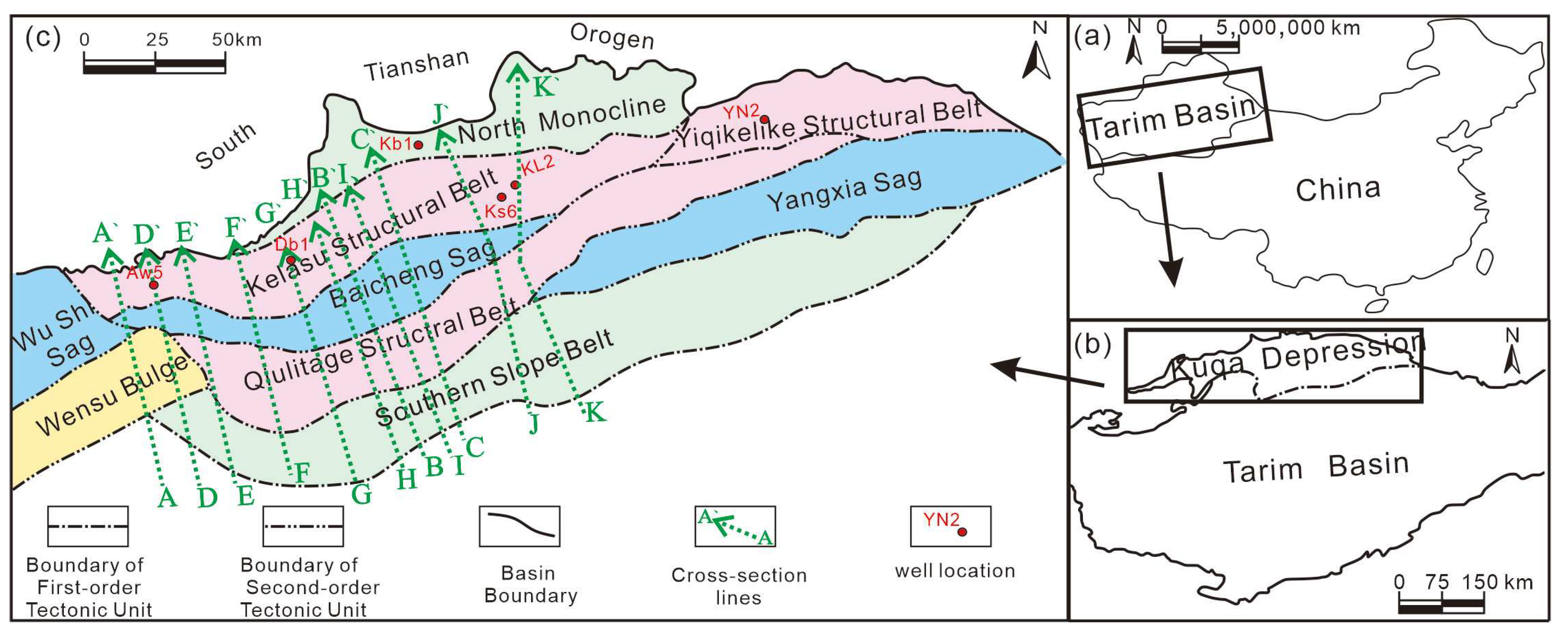
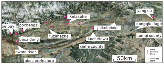
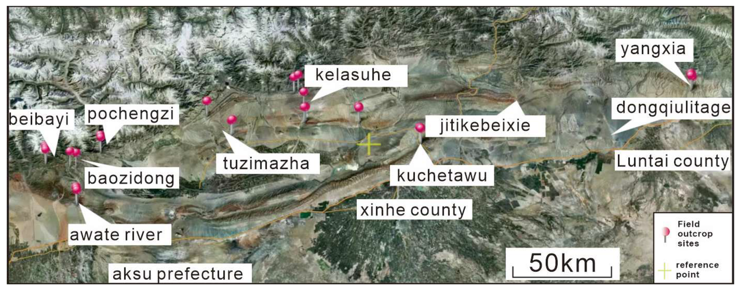
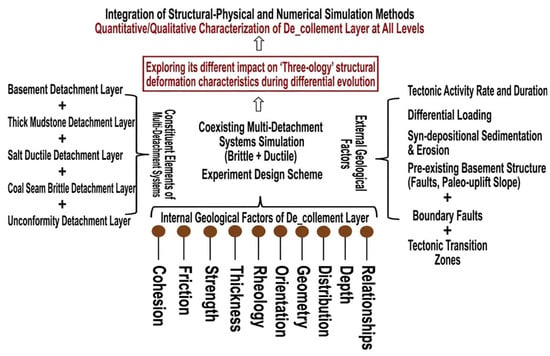
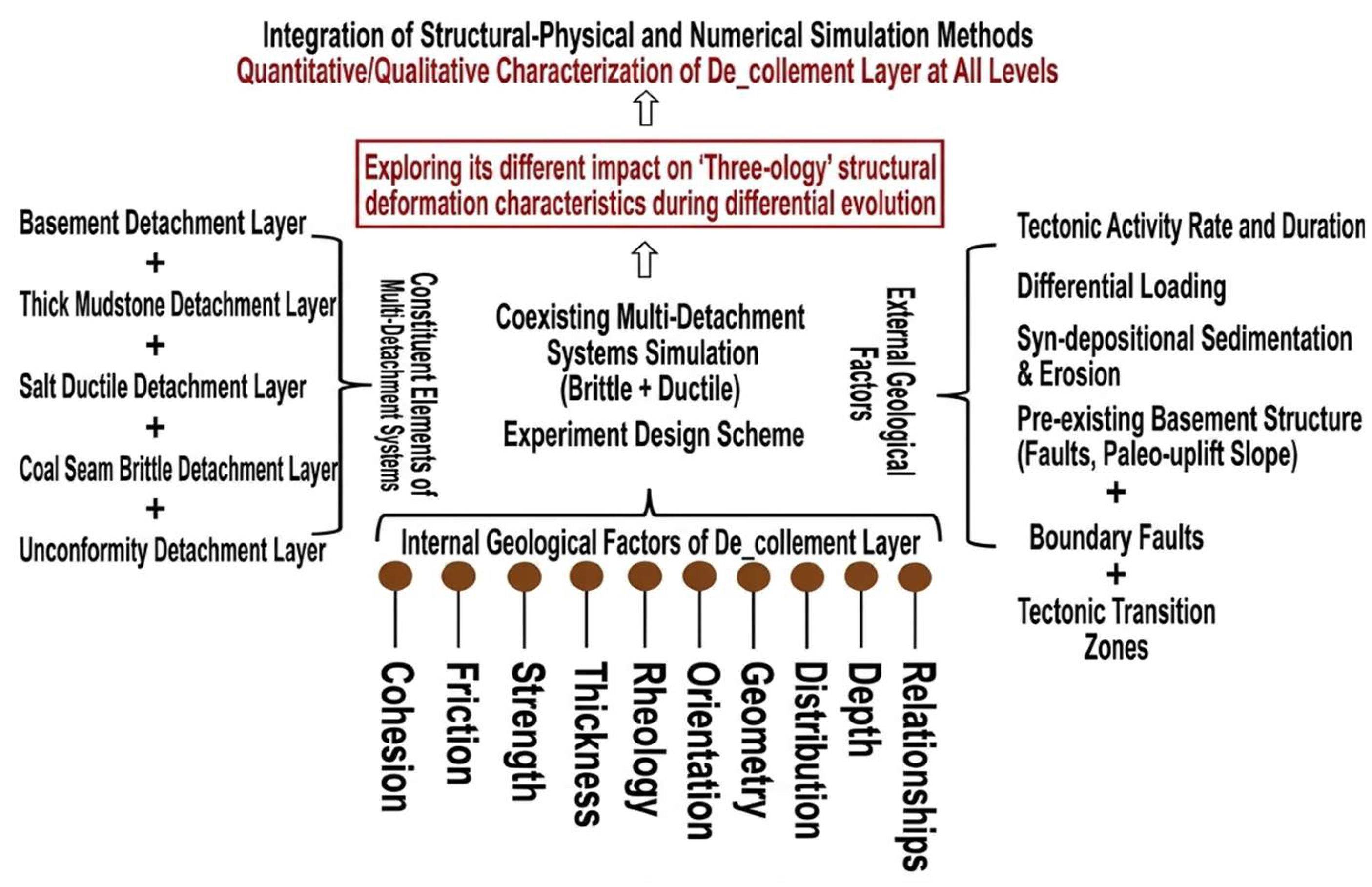
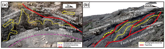
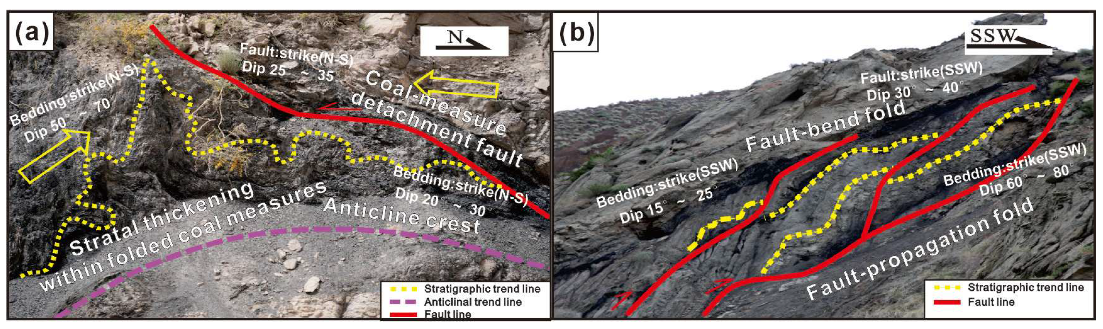
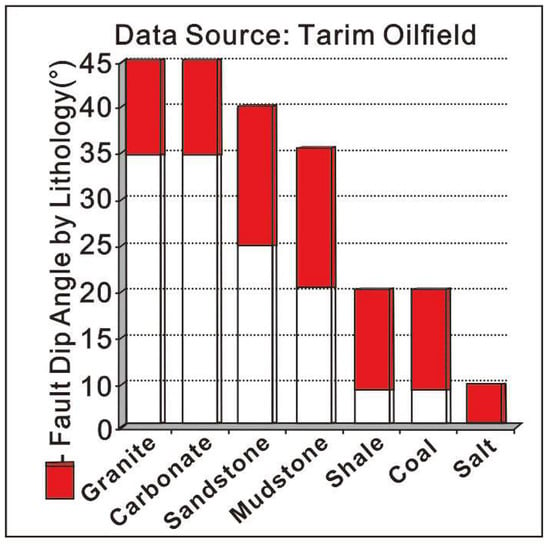
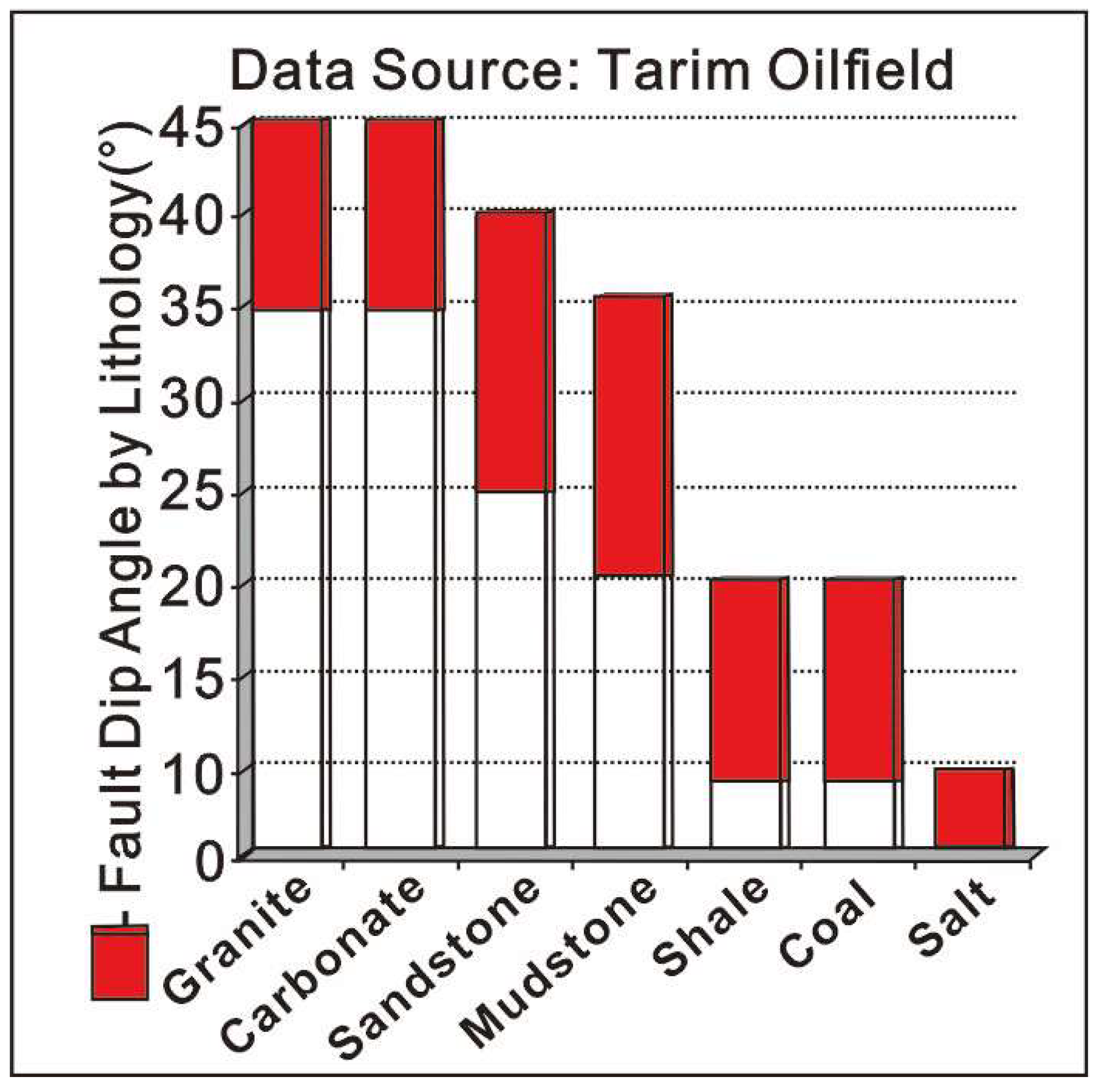
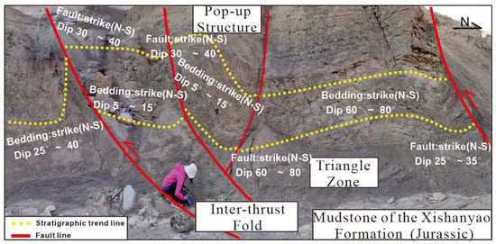
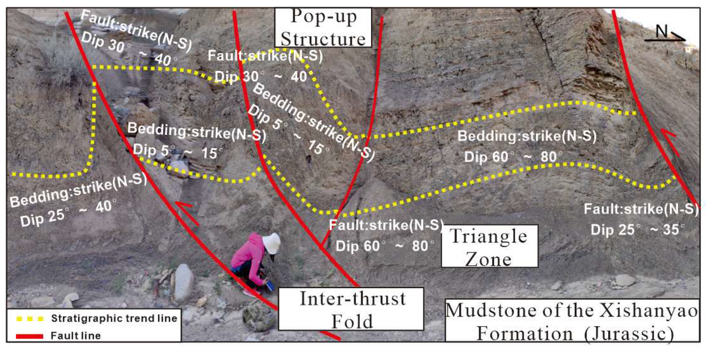
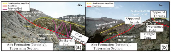
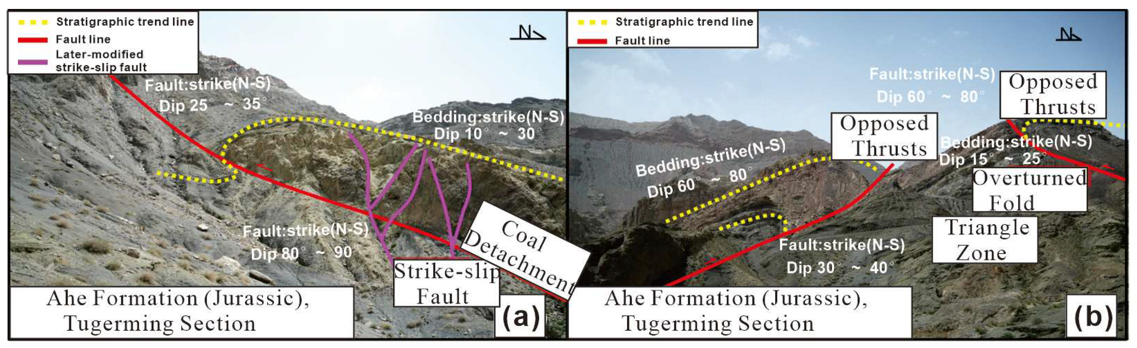
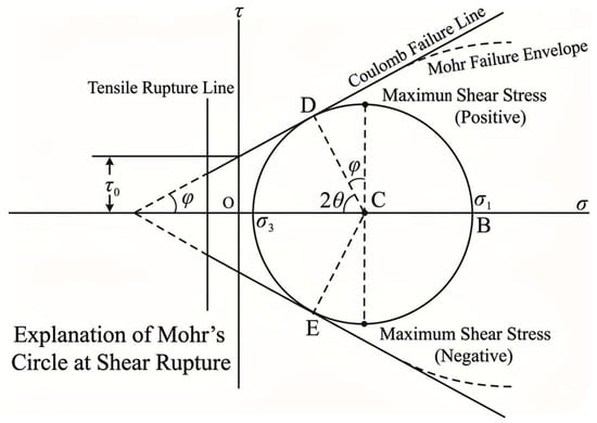
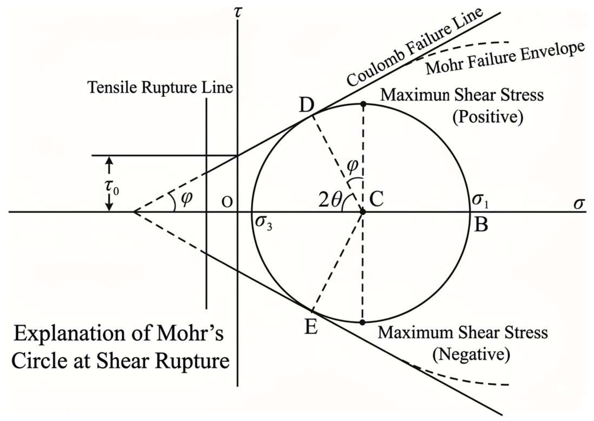
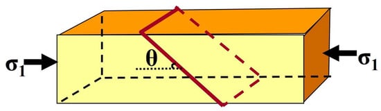
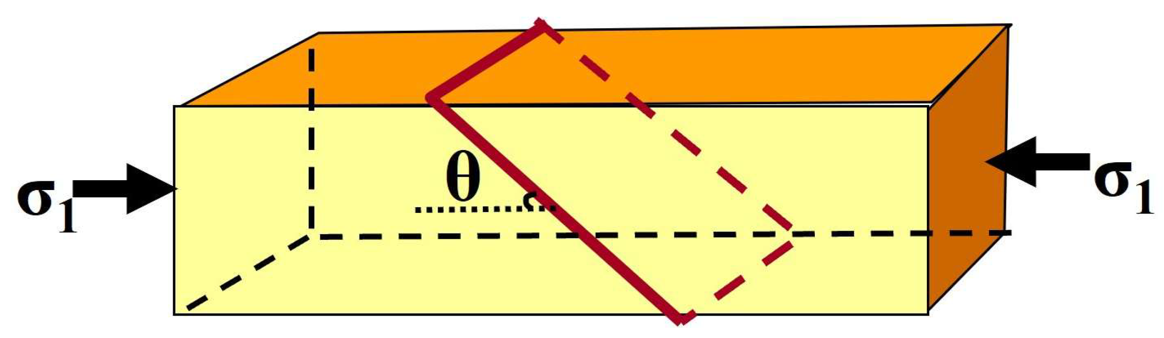
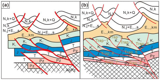
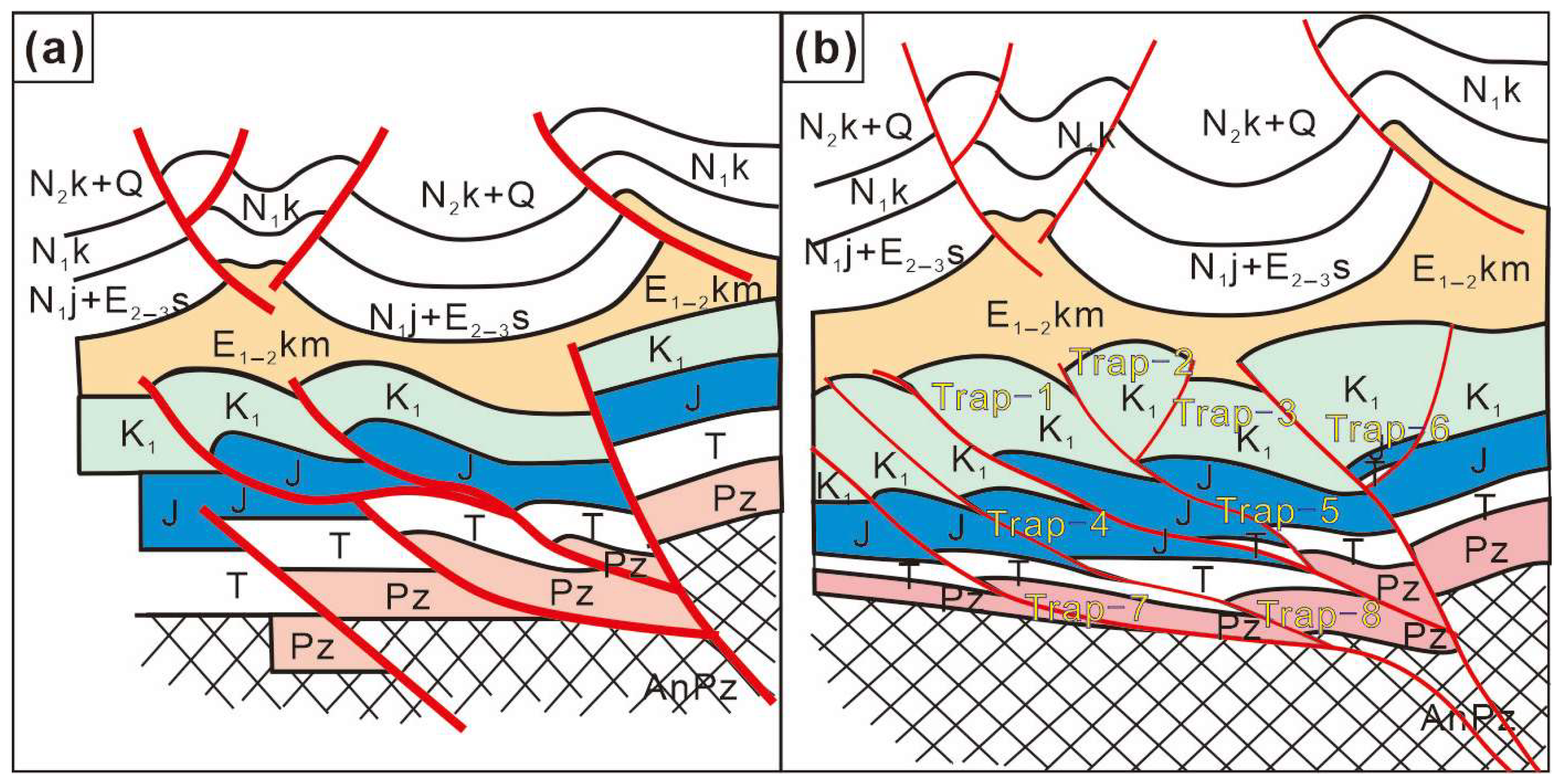
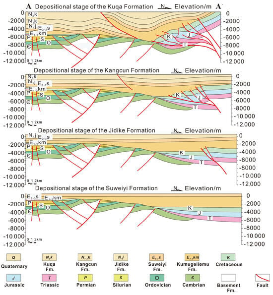
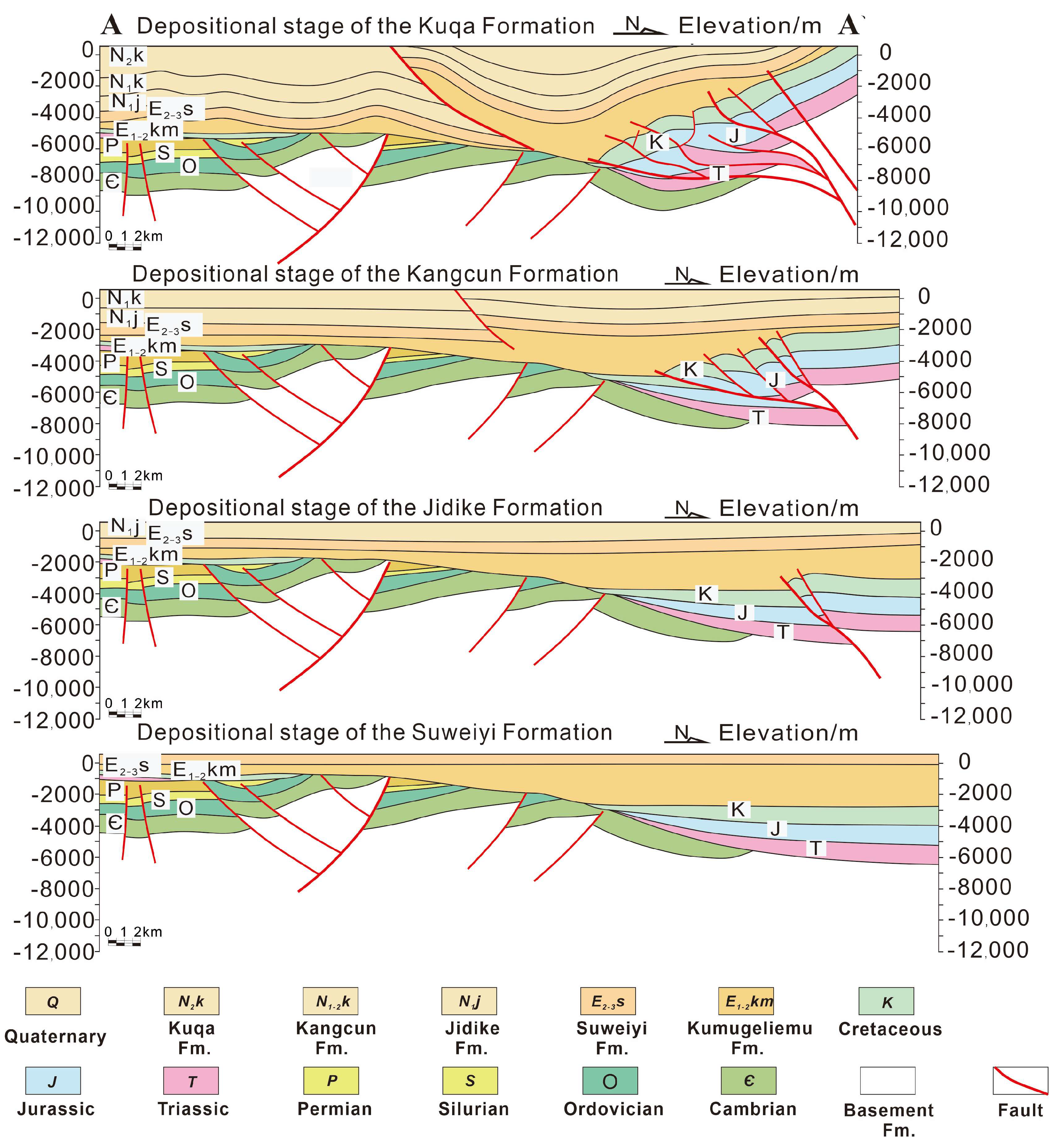
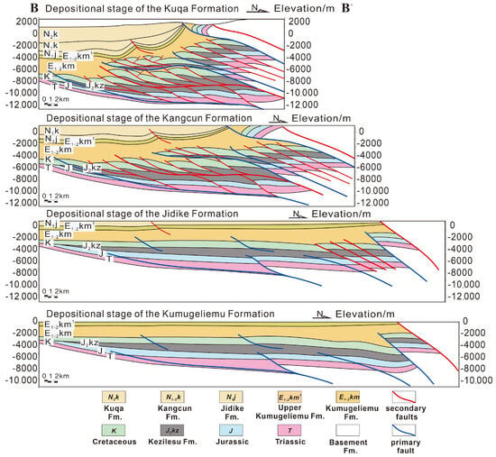
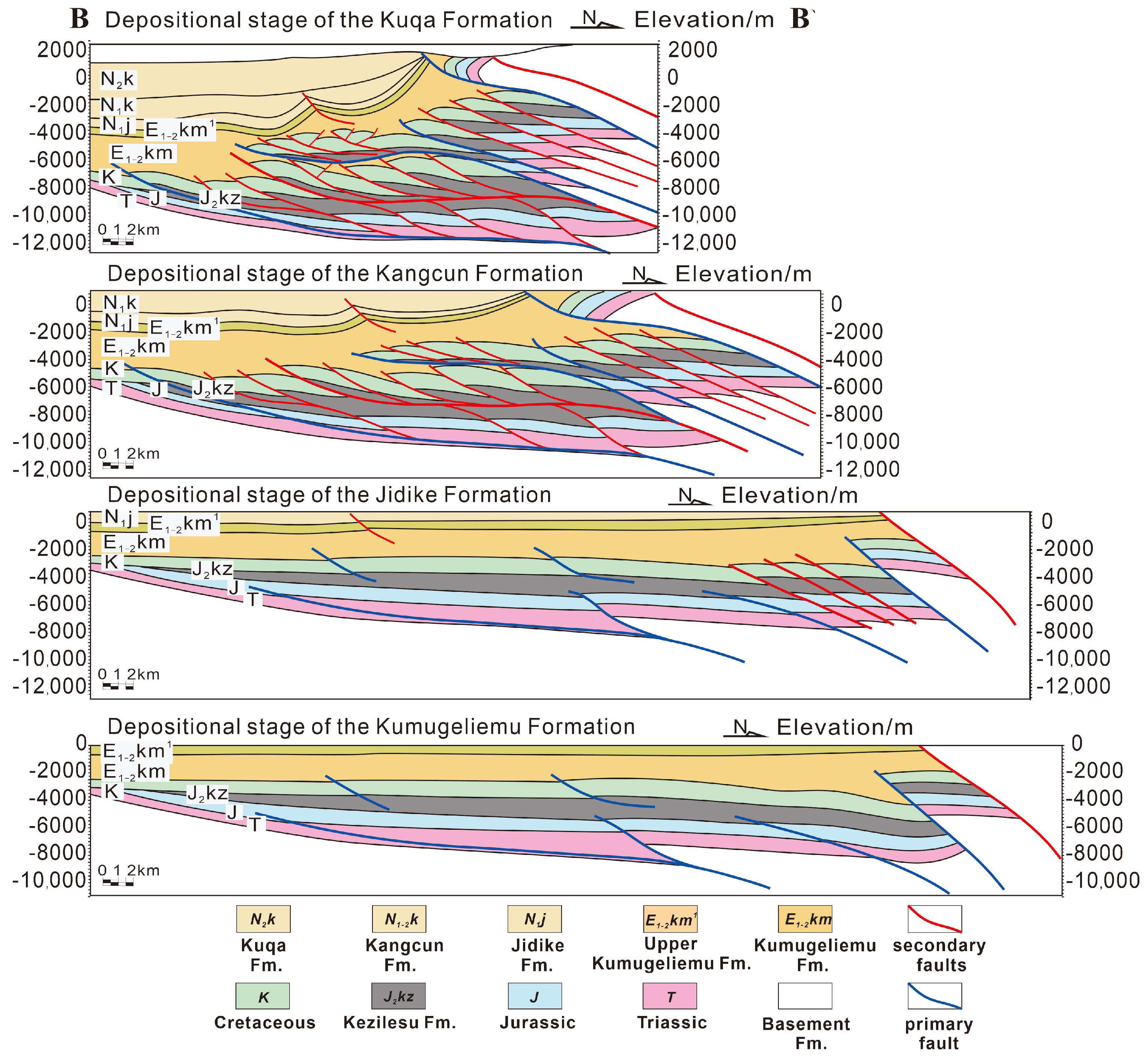
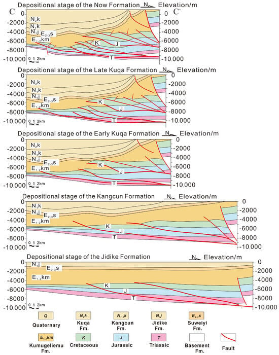
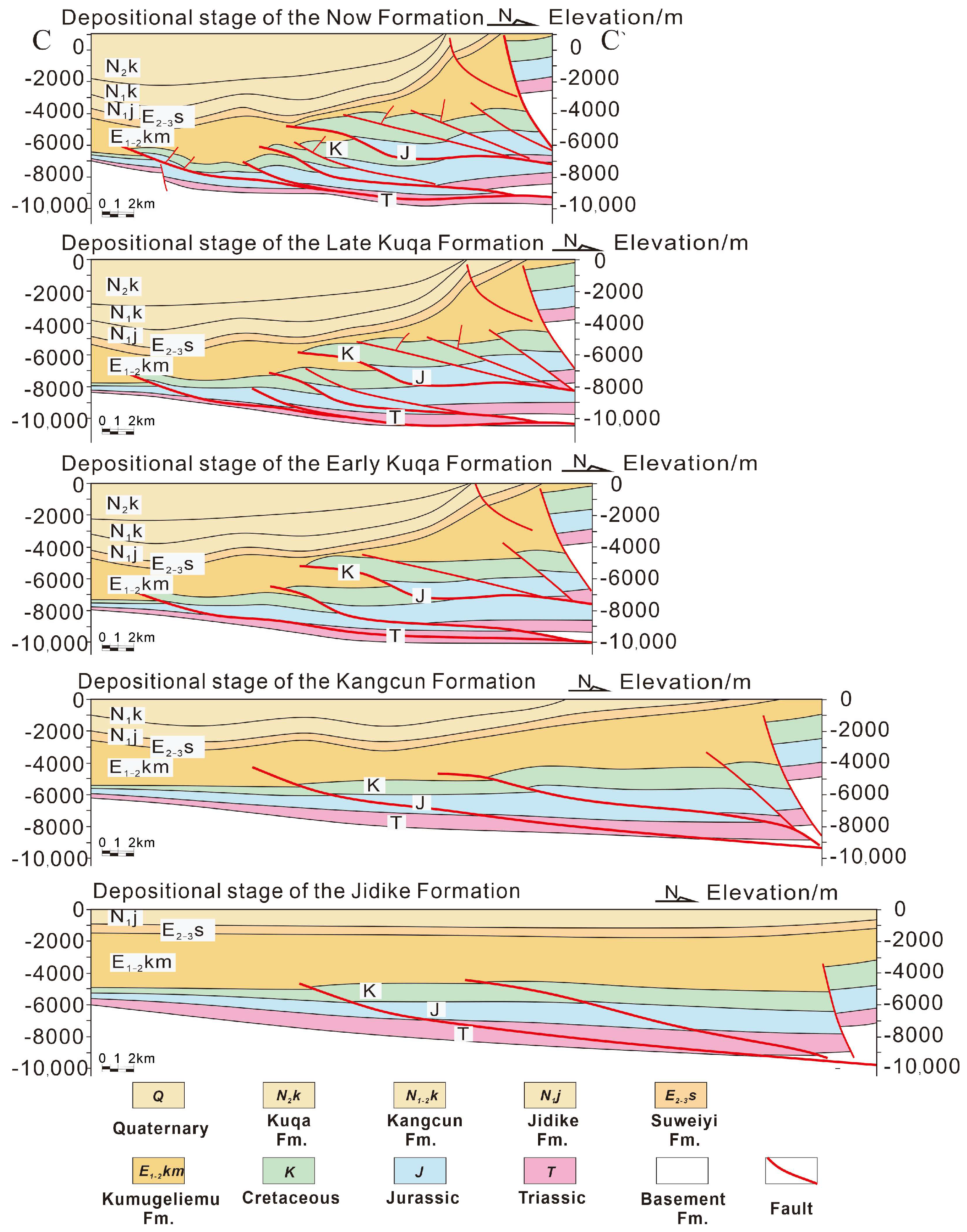
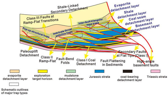
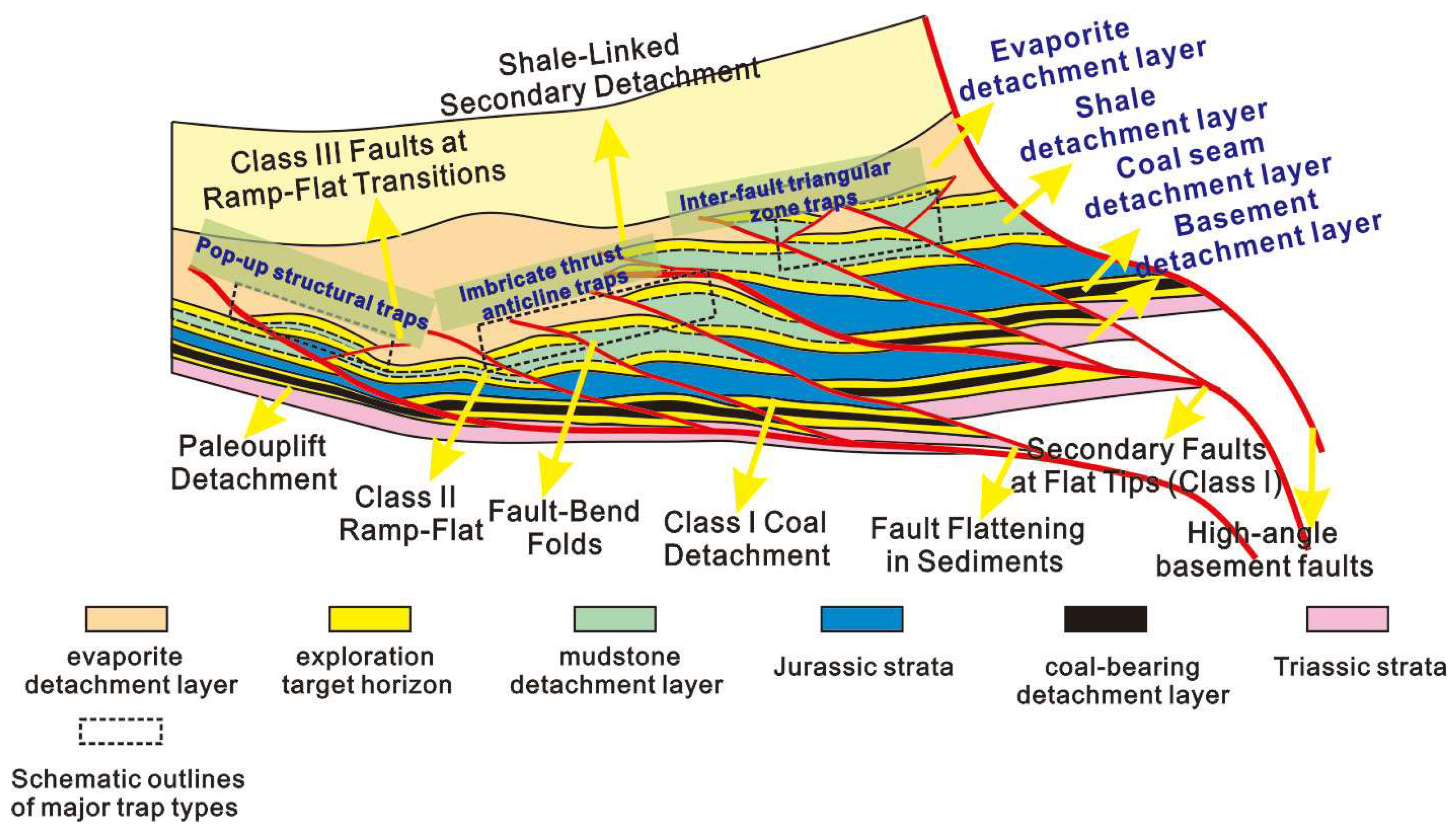
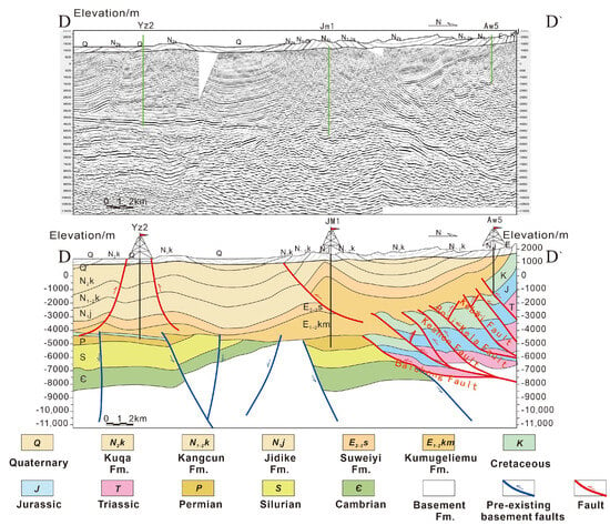
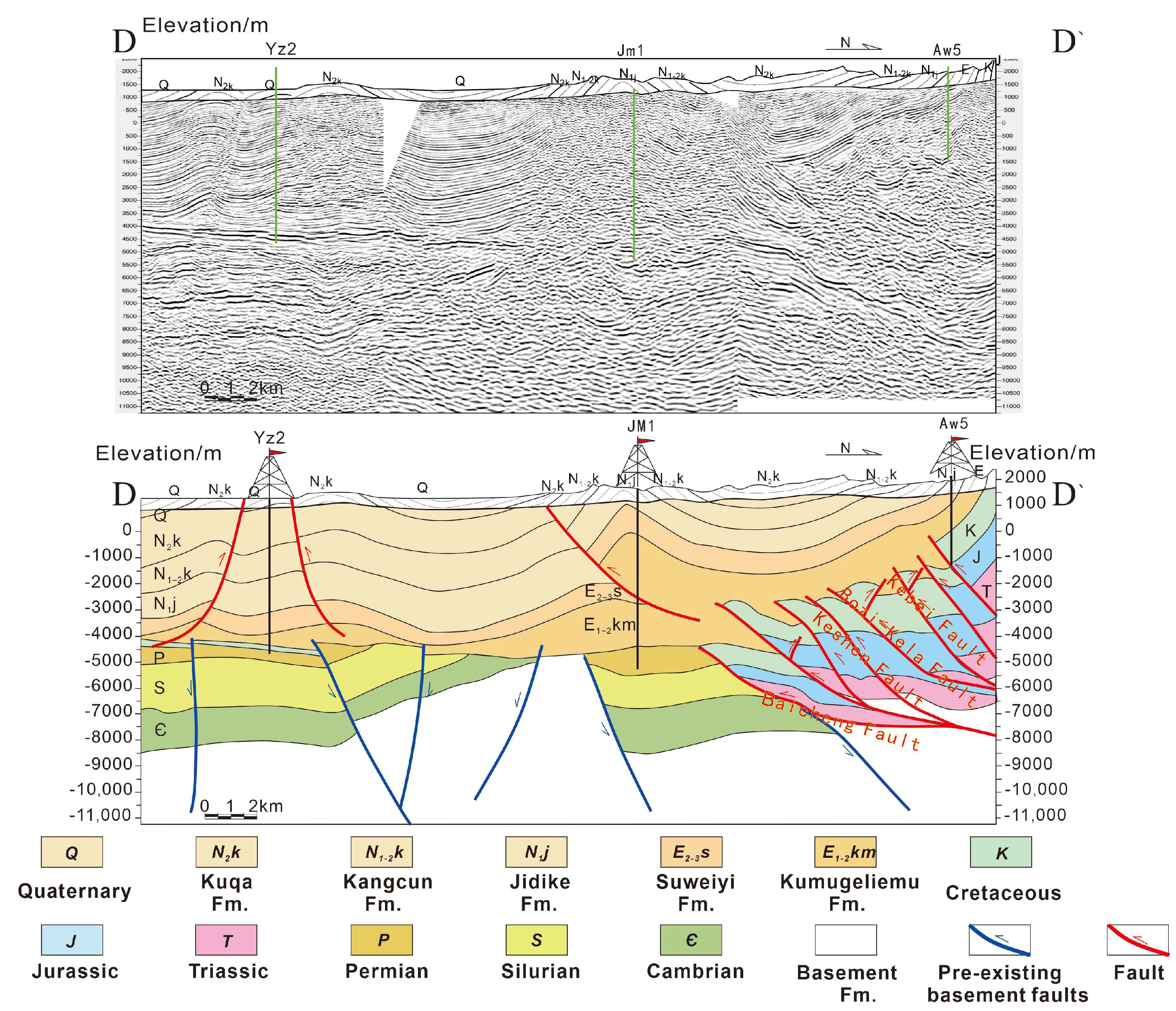
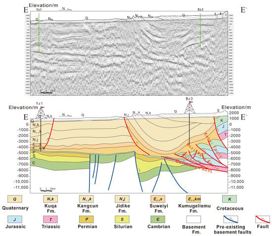
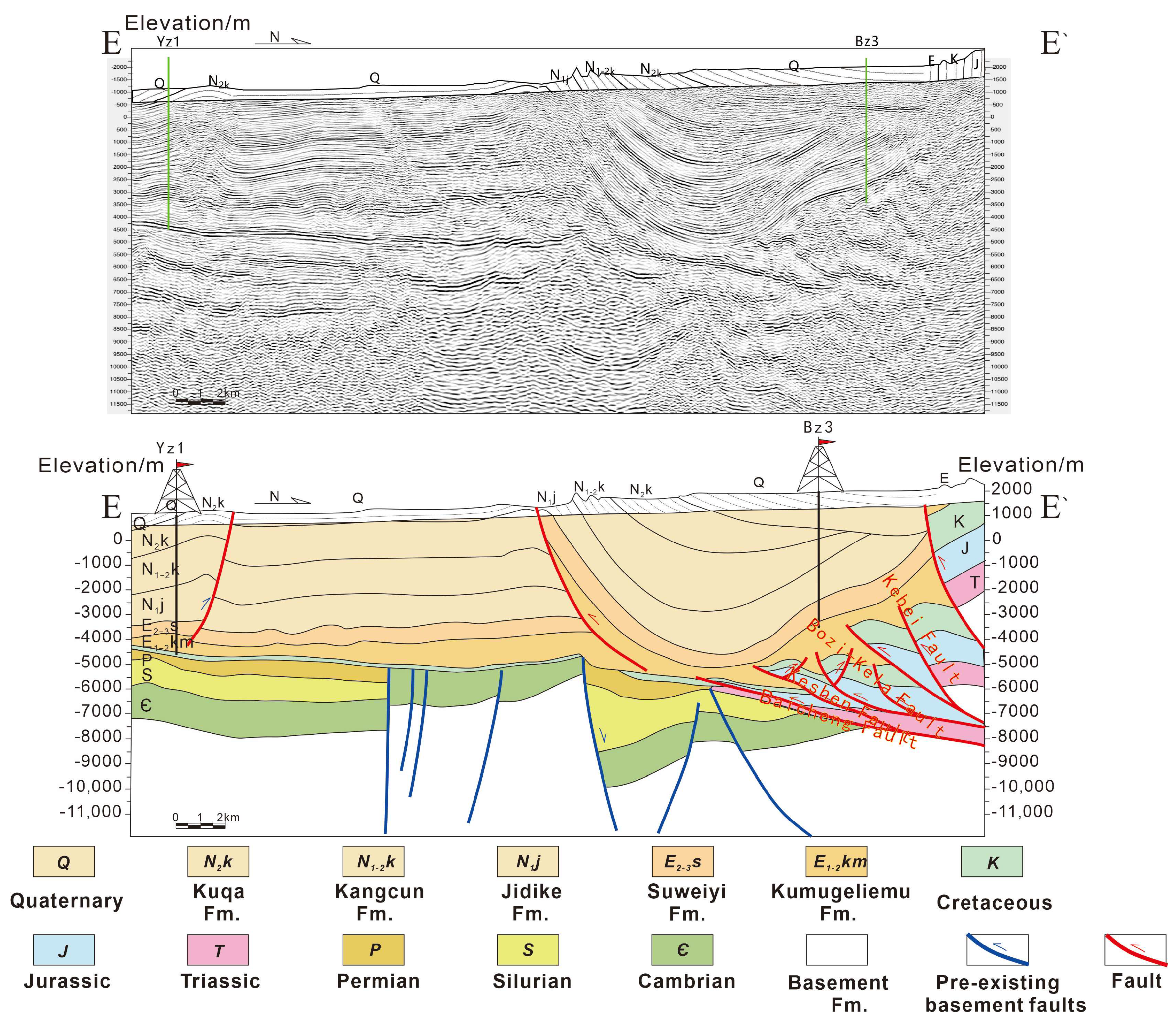
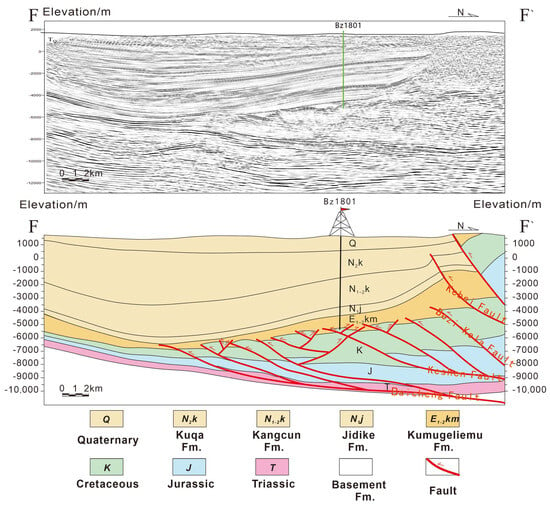
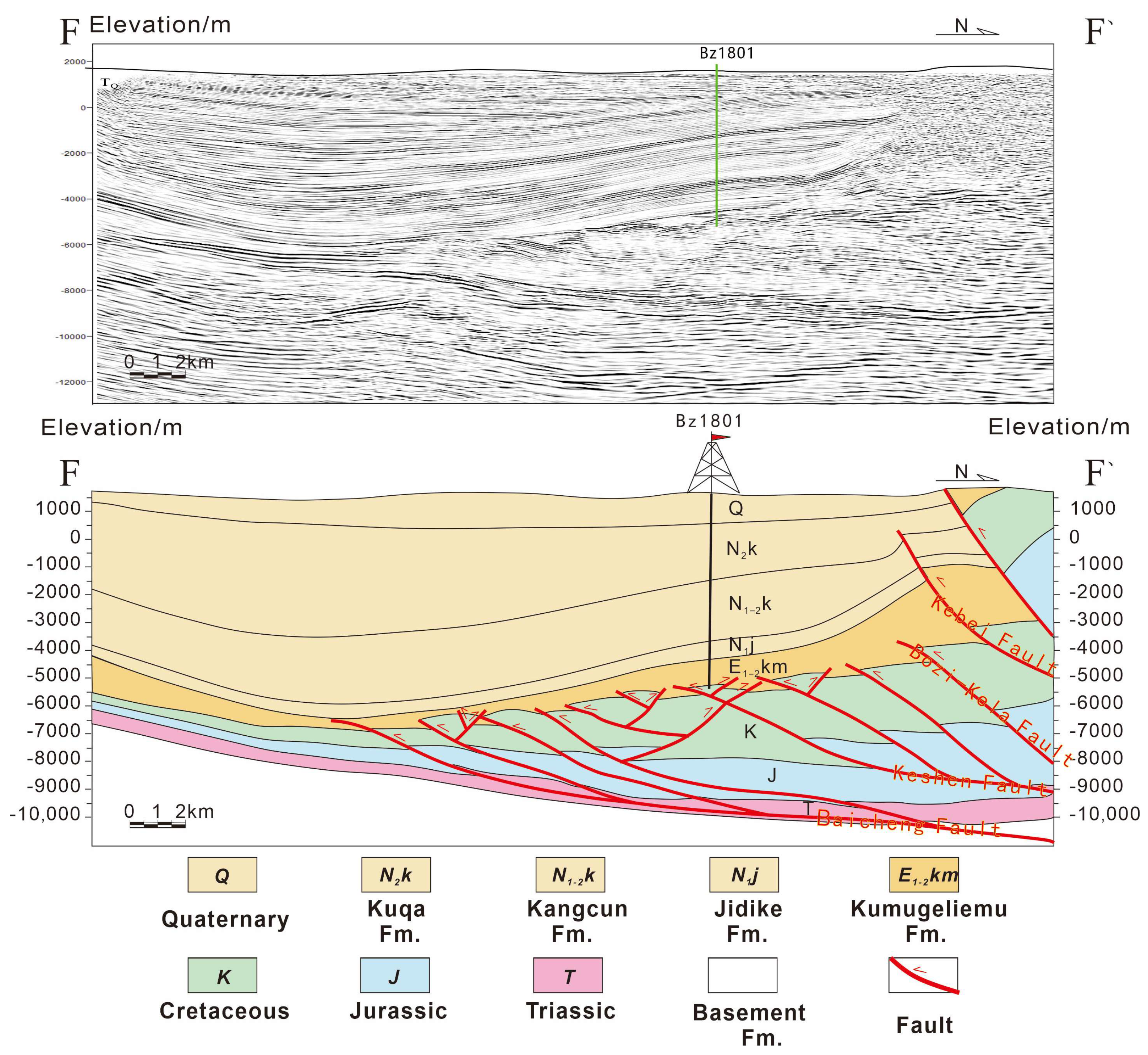
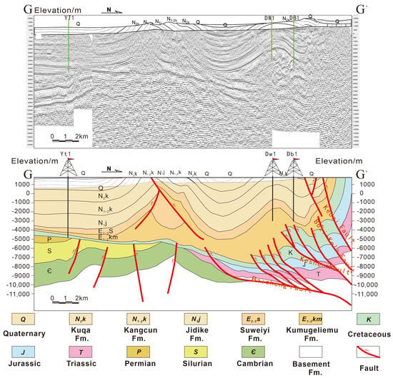
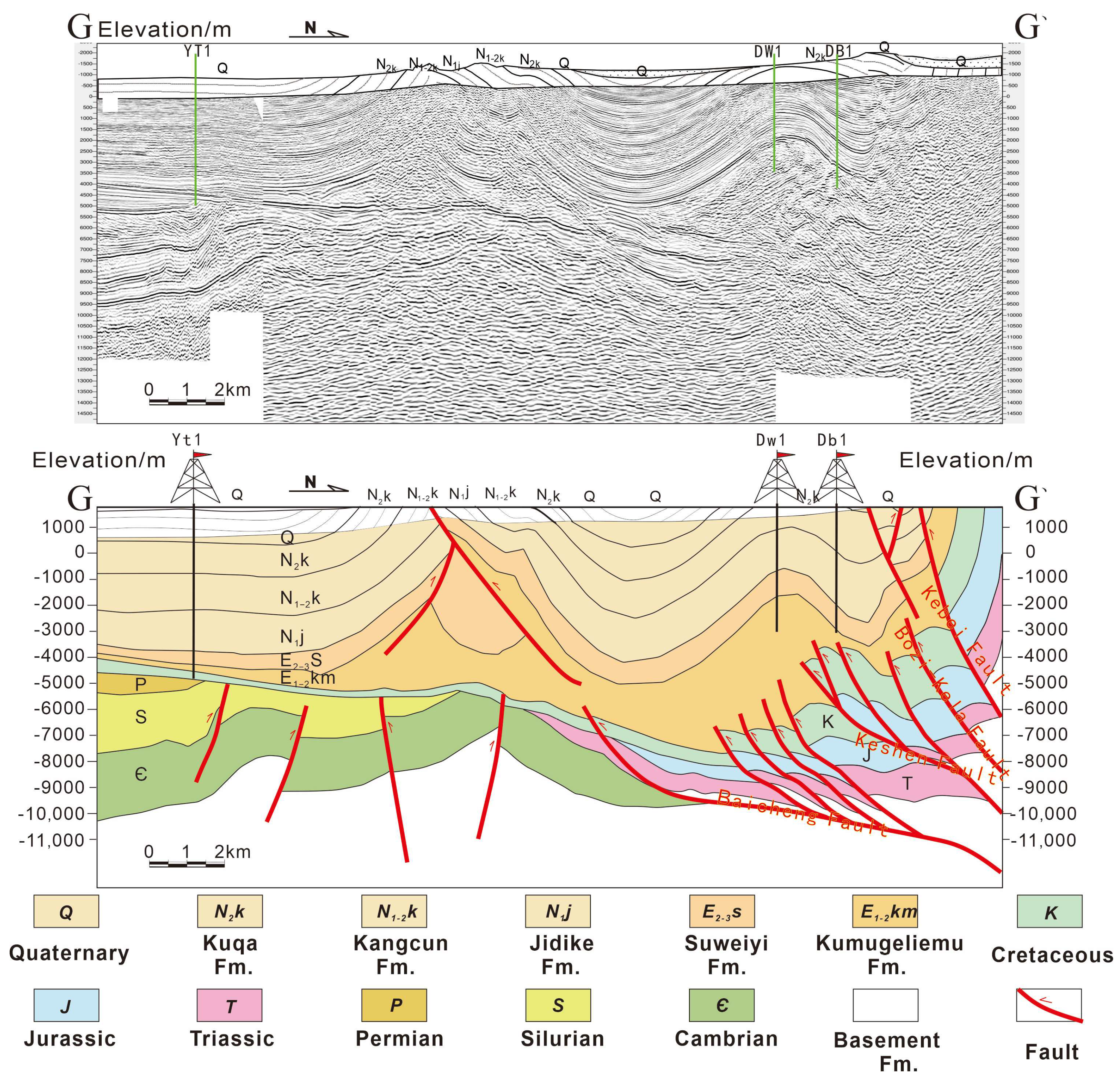
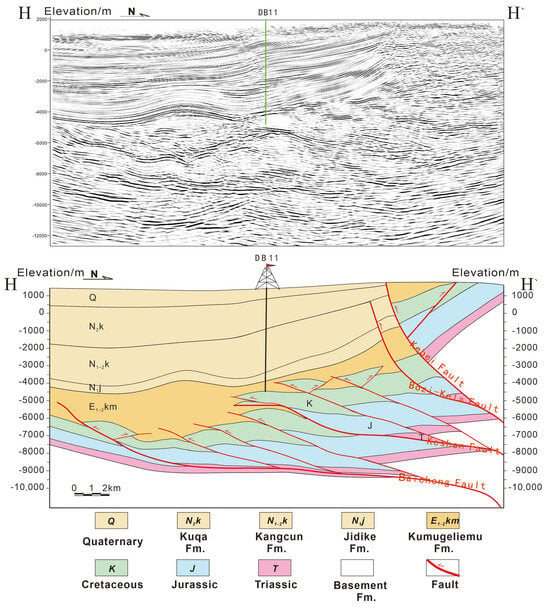
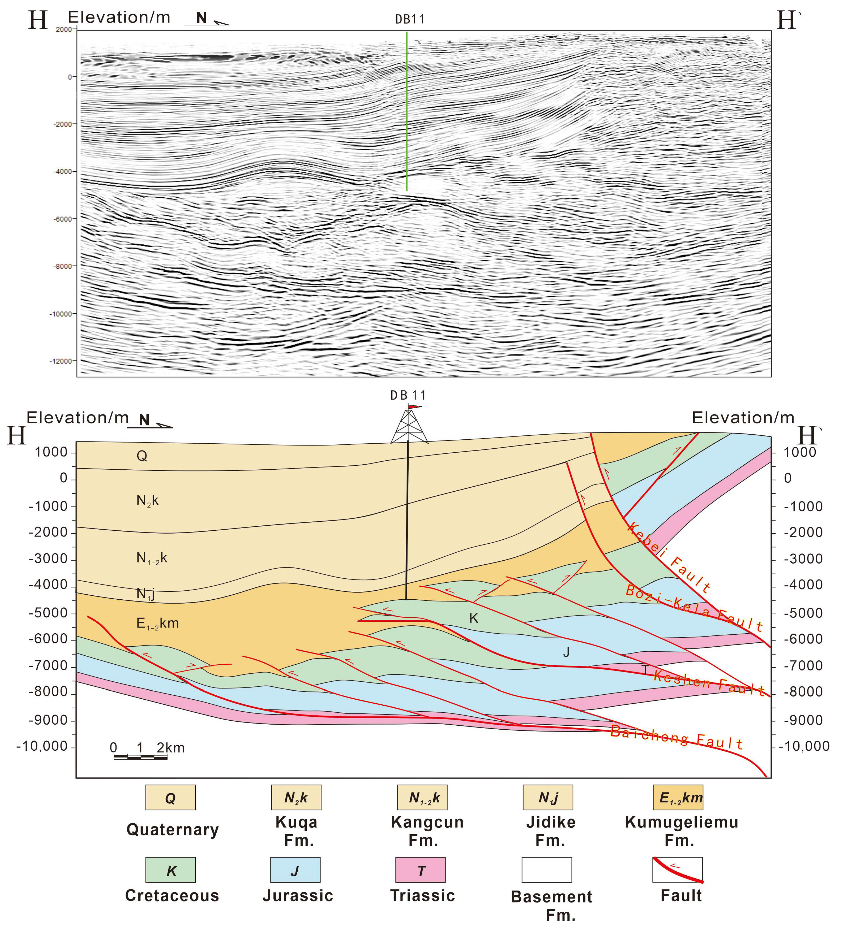
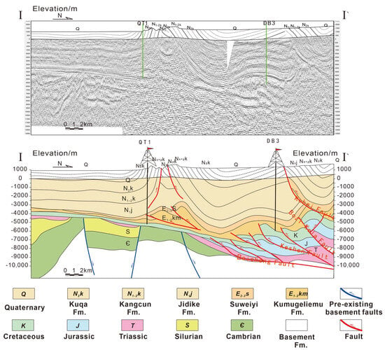
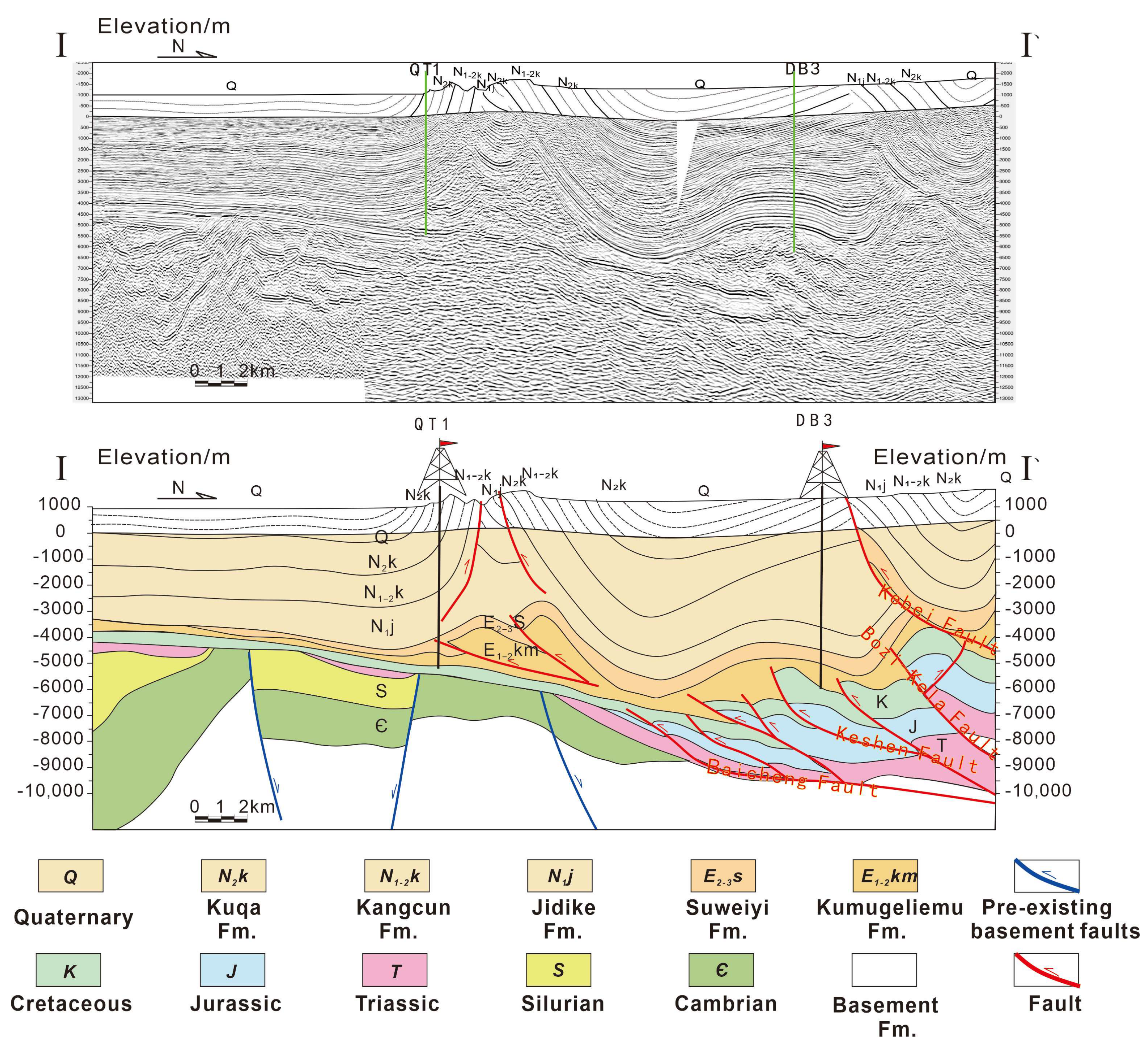
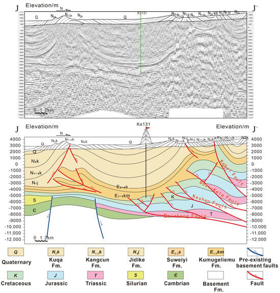
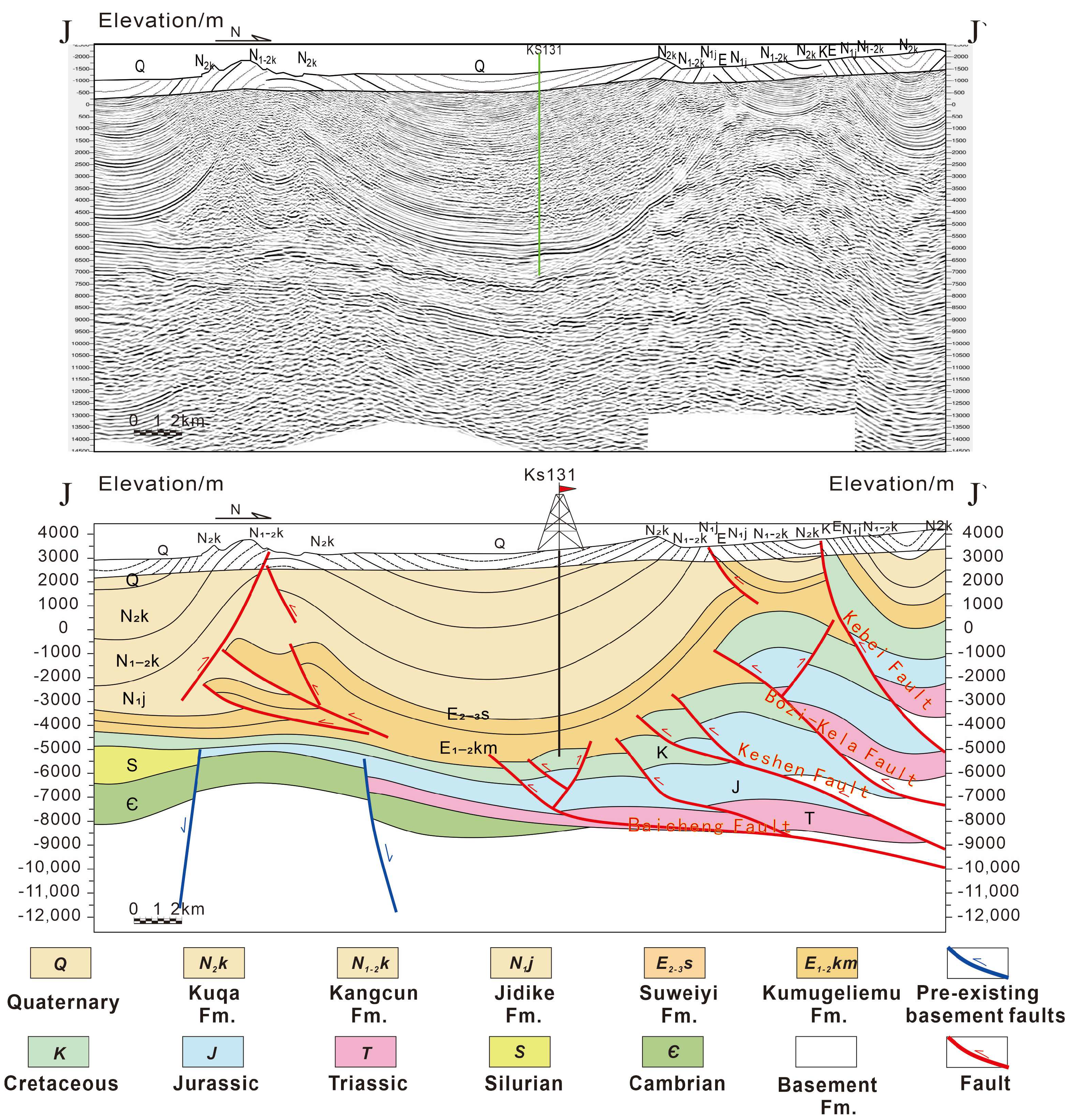
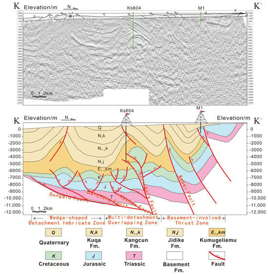
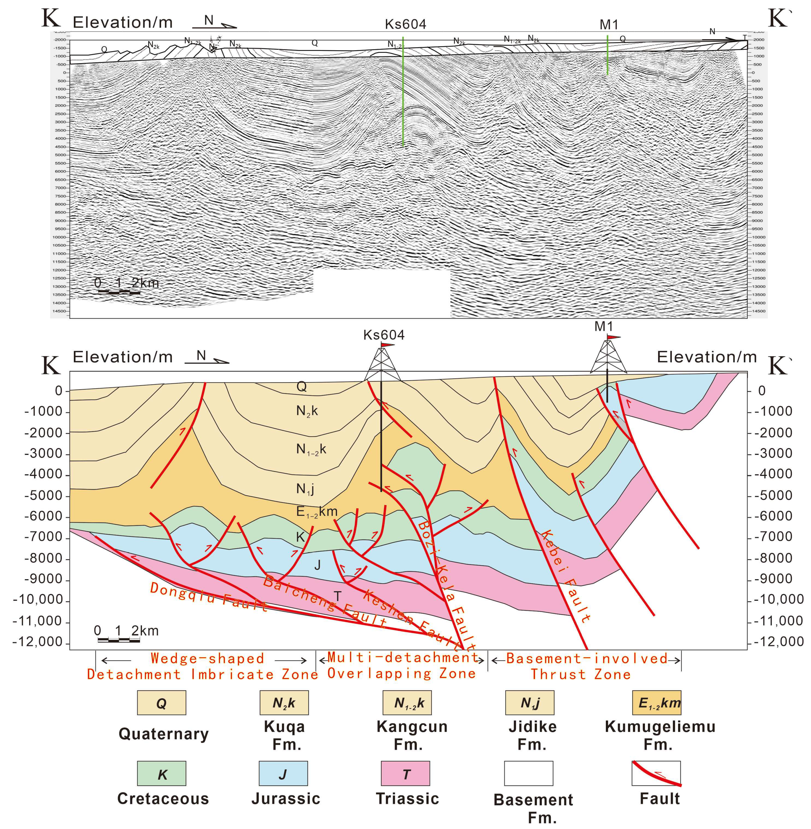
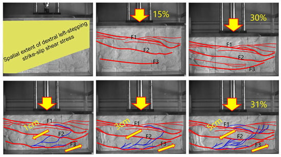
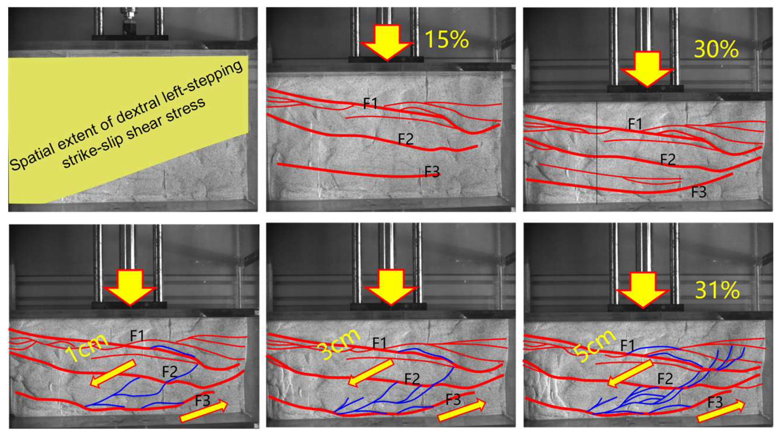
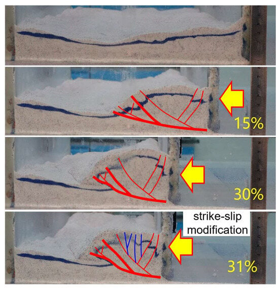
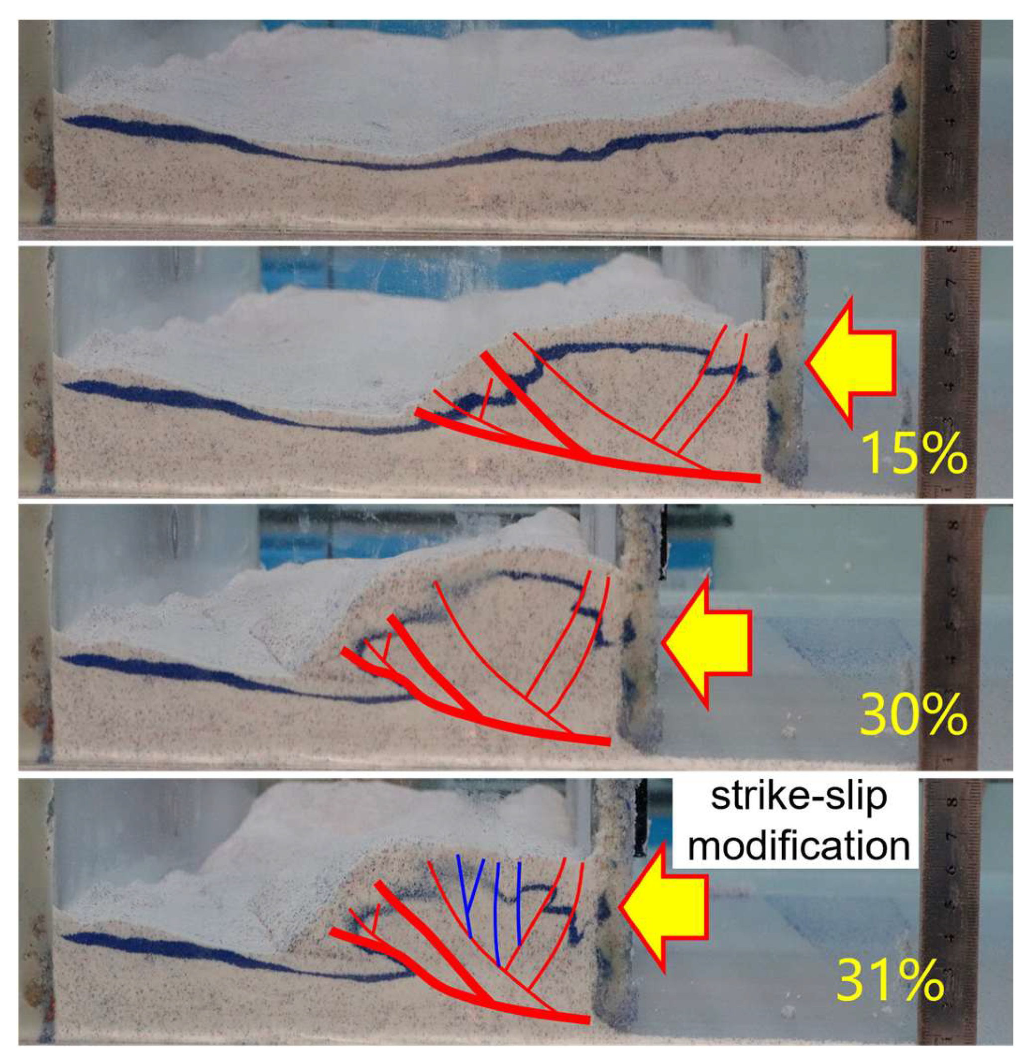
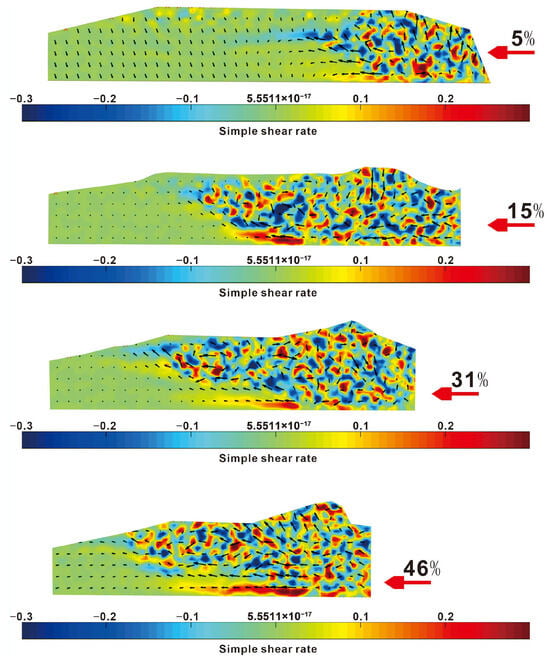
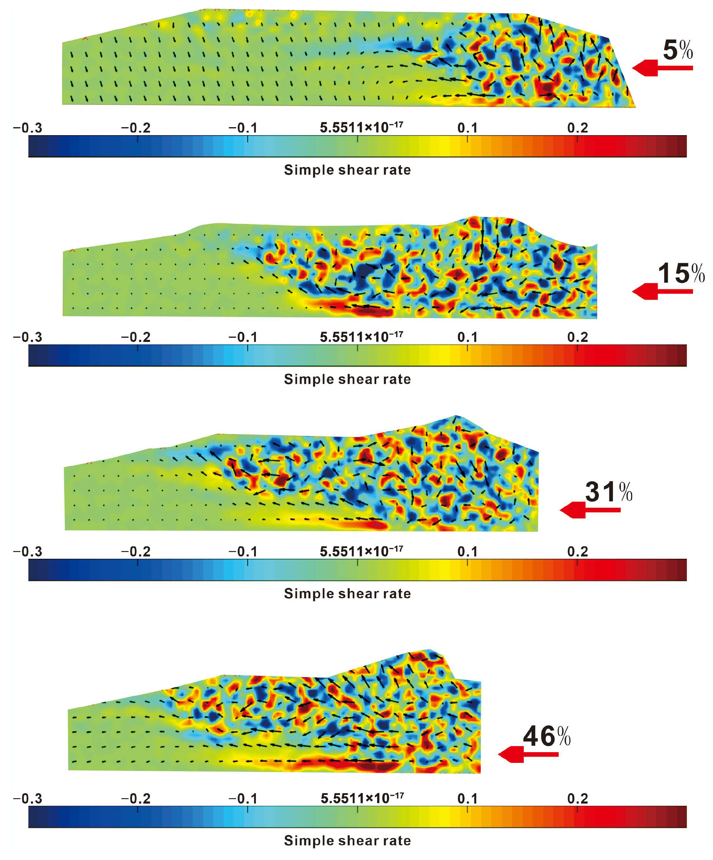
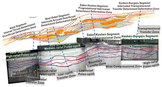
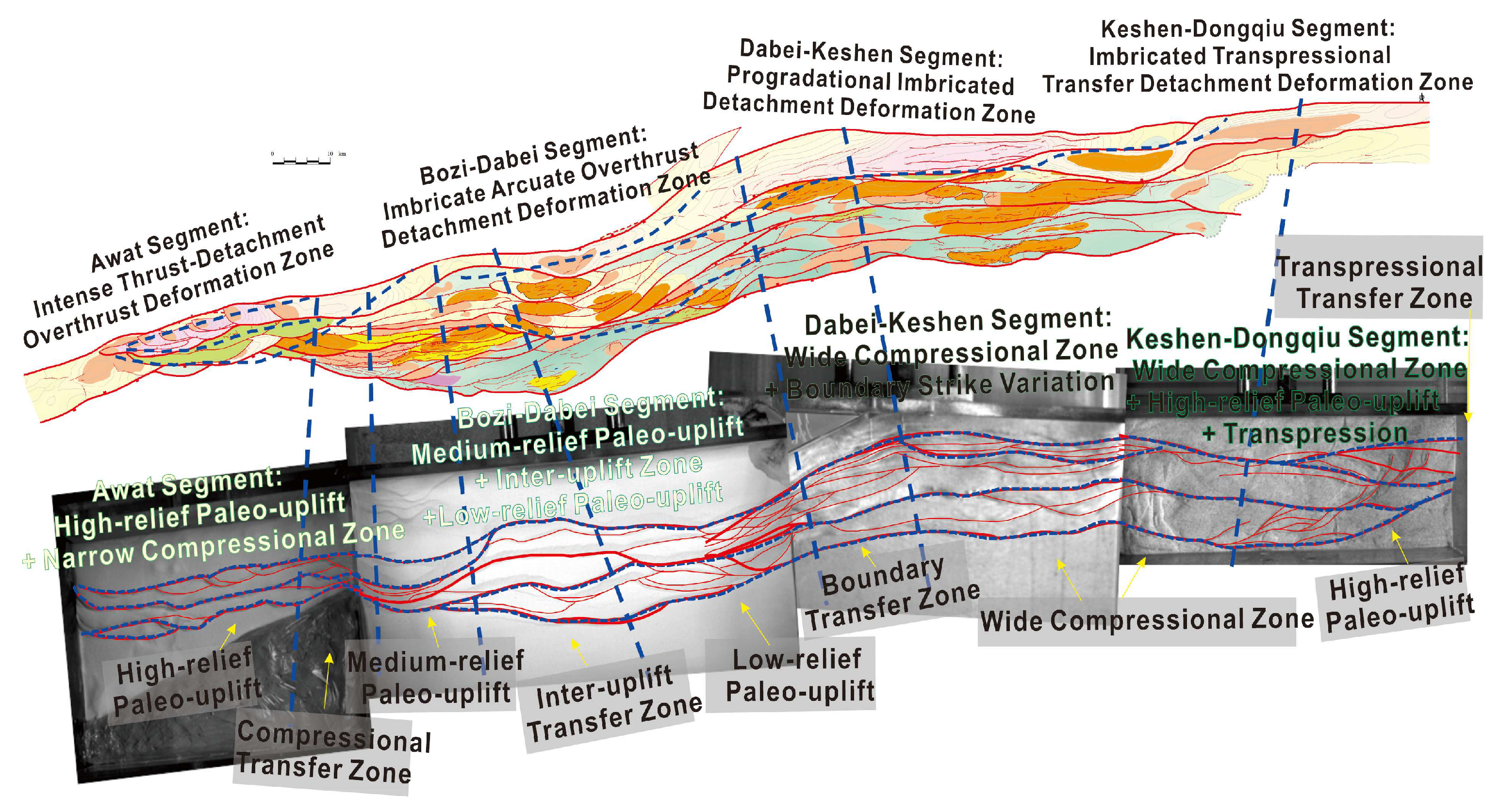

Disclaimer/Publisher’s Note: The statements, opinions and data contained in all publications are solely those of the individual author(s) and contributor(s) and not of MDPI and/or the editor(s). MDPI and/or the editor(s) disclaim responsibility for any injury to people or property resulting from any ideas, methods, instructions or products referred to in the content. |
© 2026 by the authors. Licensee MDPI, Basel, Switzerland. This article is an open access article distributed under the terms and conditions of the Creative Commons Attribution (CC BY) license.