You are currently viewing a new version of our website. To view the old version click .

Geosciences, Volume 10, Issue 11

November 2020 - 56 articles

Cover Story: 
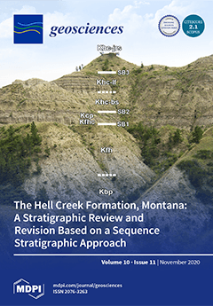
The Hell Creek Formation of North America is one of the few terrestrial units which preserve the K–Pg boundary. It is famous for its dinosaur fossils, such as Triceratops and Tyrannosaurus, which disappear at the K–Pg boundary mass extinction at the upper formational contact. This paper reviews the stratigraphy of the Hell Creek and implements a sequence stratigraphic framework to aid in regional correlations. Revisions suggest that the Hell Creek Formation probably represents ~700 k. y. of deposition. This image shows the basal formational contacts and depositional sequence boundaries in a typical section exposed near Fort Peck Lake, Montana. View this paper
  • Issues are regarded as officially published after their release is announced to the table of contents alert mailing list .
  • You may sign up for email alerts to receive table of contents of newly released issues.
  • PDF is the official format for papers published in both, html and pdf forms. To view the papers in pdf format, click on the "PDF Full-text" link, and use the free Adobe Reader to open them.

Articles (56)

  • Article
  • Open Access
6 Citations
3,311 Views
30 Pages

16 November 2020

Pumping and tracer tests are site-investigation techniques frequently used to determine hydraulic conductivity. Tomographic test layouts, in which multiple tests with different combinations of injection and observation wells are performed, gain a bet...

  • Review
  • Open Access
7 Citations
4,854 Views
10 Pages

16 November 2020

The White Sea is a small shallow semi-closed sea in the North-West of Russia. It is strongly affected by induced tides, so the tidal motion dominates in the sea. Sea ice is seasonal and the water salinity is less than in the neighbouring Barents sea...

  • Article
  • Open Access
3 Citations
3,301 Views
21 Pages

16 November 2020

The orientation and relative magnitudes of paleo tectonic stresses in the western central region of the White Mountains of New Hampshire is reconstructed using the direct inversion method of fault slip analysis on 1–10-m long fractures exposed...

  • Editorial
  • Open Access
2 Citations
3,636 Views
6 Pages

Tracking the Deep Biosphere through Time

  • Henrik Drake,
  • Magnus Ivarsson and
  • Christine Heim

15 November 2020

The oceanic and continental lithosphere constitutes Earth’s largest microbial habitat, yet it is scarcely investigated and not well understood. The physical and chemical properties here are distinctly different from the overlaying soils and the...

  • Article
  • Open Access
10 Citations
14,504 Views
20 Pages

14 November 2020

A 75 km-long, generally NE-striking ground rupture associated with the 6 February 2012 MW 6.7 (Mb 6.9) Negros earthquake was mapped on the eastern side of Negros Island, Philippines. It closely follows a previously unmapped, pre-existing fault trace...

  • Article
  • Open Access
11 Citations
2,576 Views
18 Pages

13 November 2020

Flow and transport processes in fractured systems are not yet fully understood, and it is challenging to determine the respective parameters experimentally. Studies on 10 samples of 2 different sandstones were used to evaluate the reproducibility of...

  • Article
  • Open Access
10 Citations
5,482 Views
24 Pages

13 November 2020

The Upper Rhine Graben (URG) hosts thermal anomalies that account for the development of oil fields. Recently, a geothermal power plant has been installed in this area. Data obtained in this framework provide an insight into the temperature distribut...

  • Review
  • Open Access
18 Citations
4,121 Views
15 Pages

12 November 2020

Martian meteorites provide the only direct constraints on the timing of Martian accretion, core formation, magmatic differentiation, and ongoing volcanism. While many radiogenic isotope chronometers have been applied to a wide variety of Martian samp...

  • Article
  • Open Access
10 Citations
3,653 Views
10 Pages

12 November 2020

Ground-penetrating radar and crosshole radar are applied in an underground marble mine for fault detection and to test if different geological bodies can be distinguished. Boreholes are often drilled in advance of mining to clarify the locations of o...

  • Article
  • Open Access
18 Citations
4,788 Views
18 Pages

12 November 2020

Flooding risk in urban areas is particularly high, due to the high population density and property values, including those of transport, residential, service and industrial infrastructure, among others. There are many reasons for flooding in urban ar...

of 6

Get Alerted

Add your email address to receive forthcoming issues of this journal.

XFacebookLinkedIn
Geosciences - ISSN 2076-3263Creative Common CC BY license