1. Introduction
Against the backdrop of rapid urbanization and settlement revitalization, the spatial characteristics of traditional settlements are facing significant challenges. Although existing research has applied various methods—such as the Analytic Hierarchy Process, questionnaire surveys, and spatial perception theory—to the fields of urban planning, settlement studies, and tourism research, and has extensively explored traditional settlement spaces from multiple dimensions—including aging-friendly renovation [
1], park optimization [
2], perceptions of public spaces [
3,
4,
5,
6,
7], variations in cultural spaces [
8,
9], landscape space evaluation [
10,
11,
12,
13,
14], destination image [
15,
16], and satisfaction evaluation [
17]—thereby demonstrating the broad applicability and interdisciplinary value of this methodological framework across different spatial scales and research subjects, two significant shortcomings remain. First, research methods are predominantly qualitative, lacking the systematic incorporation of quantitative indicators and statistical testing, which results in highly subjective findings that are difficult to compare across studies or generalize more broadly. Second, research subjects are overly concentrated on designated settlements, such as those of historical and cultural significance, while severely insufficient attention has been paid to traditional watershed-based settlements that integrate hydrological ecology, cultural corridors, and agricultural production functions. This academic gap leaves the conservation and restoration of such settlements lacking a scientific basis.
In fact, the watershed environment profoundly shapes the spatial characteristics of settlements and serves the dual functions of ensuring ecological security and preserving regional culture. The West Liao River Basin is one of the cradles of Chinese civilization and is widely recognized as China’s third-largest “mother river,” after the Yellow River and the Yangtze River [
18]. Since the reform and opening-up, its ecological and cultural environments have undergone drastic changes, and its spatial characteristics have been systematically impacted. At the same time, as a key national agricultural and grain-producing region, the sustainable development of settlements in this basin has become a provincial strategic priority, creating an urgent need for a quantifiable and verifiable evaluation tool. Accordingly, this paper selects the West Liao River Basin as a case study to construct an evaluation system for spatial perception elements of traditional settlements in river basins. The aim is to address the current research limitations characterized by “qualitative dominance and narrow typological scope,” thereby providing quantitative evidence and methodological references for the precise conservation, landscape management, and targeted policy development of traditional settlements in northern regions characterized by multi-ethnic integration.
2. Research Object and Innovation
2.1. Scope of the Research
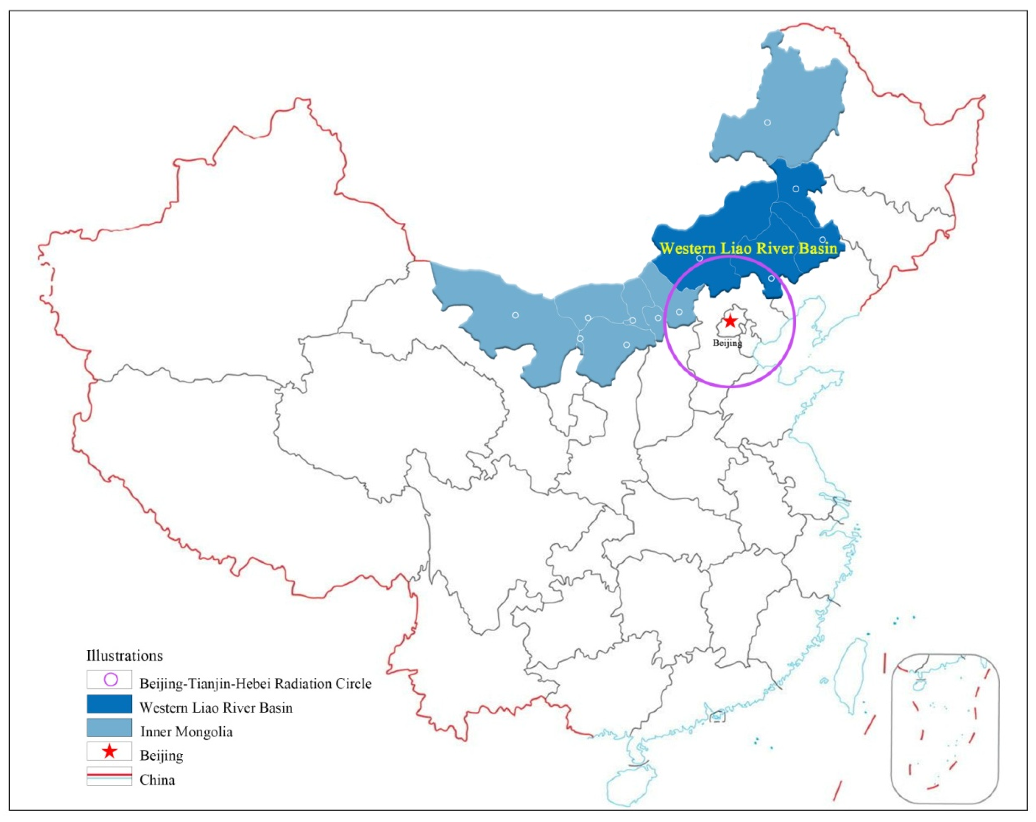
The West Liao River is one of China’s seven major rivers and the largest river in Northeast China. The West Liao River Basin within Inner Mongolia is located in the upper reaches of the West Liao River, in the central-eastern part of Inner Mongolia and within the Beijing–Tianjin–Hebei radiation circle (see
Figure 1). This basin covers an area of 127,000 km
2, accounting for 92% of the total area of the West Liao River Basin. The West Liao River Basin in Inner Mongolia encompasses three districts of Chifeng, two districts of Tongliao, one district of Xing’an League, and one district of Xilingol League. Chifeng and Tongliao together account for 97.5% of the basin’s area [
19].
The West Liao River Basin in Inner Mongolia is representative for the following reasons: (1) Cultural advantages: The regional civilization centered on the West Liao River Basin holds a prominent and significant position in the 5000-year history of Chinese civilization and is one of the cradles of Chinese culture. It retains abundant tangible and intangible cultural heritage. (2) Natural advantages: The West Liao River Basin in Inner Mongolia exhibits distinct natural ecological advantages and is rich in natural resources, including mountains, rivers, forests, lakes, and grasslands. (3) Location advantages: Situated within the radiation range of Beijing, Tianjin, and Hebei, the West Liao River Basin in Inner Mongolia possesses obvious locational advantages, a dense population, and substantial market potential. (4) Policy advantages: The West Liao River Basin in Inner Mongolia has actively responded to national policies on watershed protection and development, with effective policy implementation. In 2021, the 14th Five-Year Plan for the Protection and Development of the West Liao River Basin in Inner Mongolia was officially issued and implemented.
2.2. Research Object
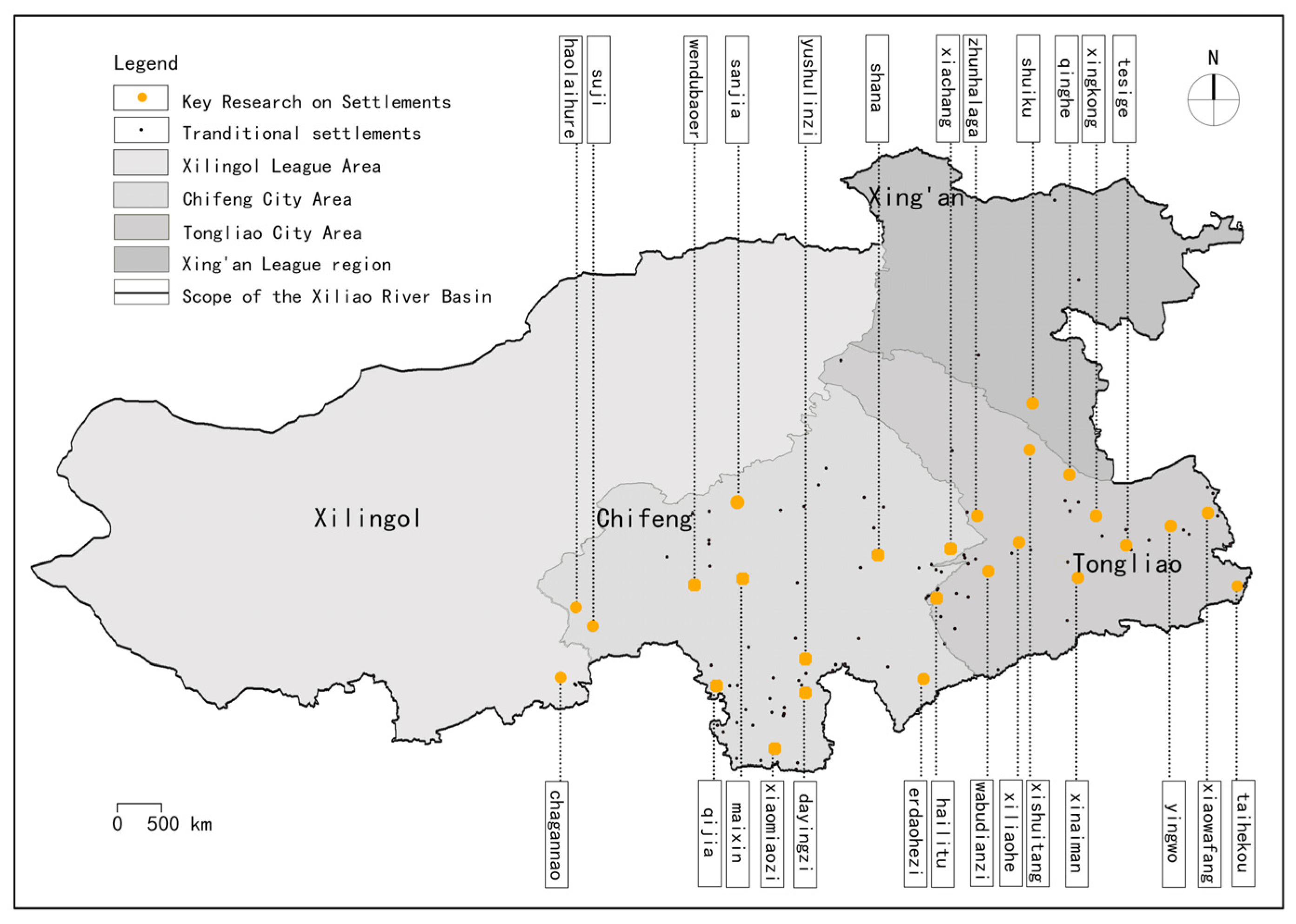
This study focuses on a total of 130 traditional settlements within the West Liao River Basin, including 42 in Chifeng City, 54 in Tongliao City, 21 in Xing’an League, and 13 in Xilingol League, which are concentrated in the Chifeng and Tongliao areas. The study accounts for typicality as well as regional differences and imbalances. Leveraging the uniformity of the natural geographical environment of the West Liao River Basin and the variations in administrative divisions, the research aims to achieve comprehensive coverage of the entire basin, urban areas, and natural environments. A total of 26 settlements were selected as key research samples (see
Figure 2). Based on existing literature, a combination of in-depth interviews and field surveys was employed to conduct extensive fieldwork on these key settlements. This approach enabled the collection of effective first-hand information, the establishment of a spatial characteristics database for traditional settlements in the West Liao River Basin, the exploration of the spatial characteristics of traditional settlements, and the overlapping and classification analysis of different features. These efforts facilitate subsequent research.
2.3. Innovation
The innovation and advantages of constructing an evaluation system for spatial perception elements of traditional settlements using the IPA method in this study are as follows: (1) Expanding the research scope. This study focuses on traditional settlements within watershed areas that possess dual historical, cultural, and natural ecological values, thereby broadening the previous emphasis on traditional settlement areas rich in historical and cultural heritage. (2) Innovating the research methodology. The application of the IPA method effectively addresses the limitations of subjective research approaches. This method facilitates a transition from qualitative description to quantitative diagnosis. By integrating users’ perceptions of the “importance” and “satisfaction” of spatial elements into a two-dimensional quadrant analysis framework, it enables a detailed deconstruction of multidimensional elements and effectively identifies weak elements requiring urgent intervention as well as resource redundancy resulting from excessive supply. Its core advantage lies in its visually oriented decision-making output, which directly generates priority strategies for differentiated protection and activation, thereby providing a scientific foundation for the adaptive renewal of traditional settlements in the basin.
3. Method
3.1. IPA Research Method
To systematically explore the perception structure of residents and tourists regarding the spatial characteristics of traditional settlements in the West Liao River Basin, to identify the deviation between their expected perception and actual experience of these spatial characteristics, to accurately pinpoint the weak links in the current protection and inheritance of spatial characteristics, and to provide a scientific basis for the protective restoration and sustainable utilization of these characteristics, this study introduces the Importance–Satisfaction Analysis (IPA) method. This method, proposed by Martilla and James in 1977, requires respondents to quantitatively evaluate each indicator from two dimensions: importance and satisfaction (or perceived satisfaction) [
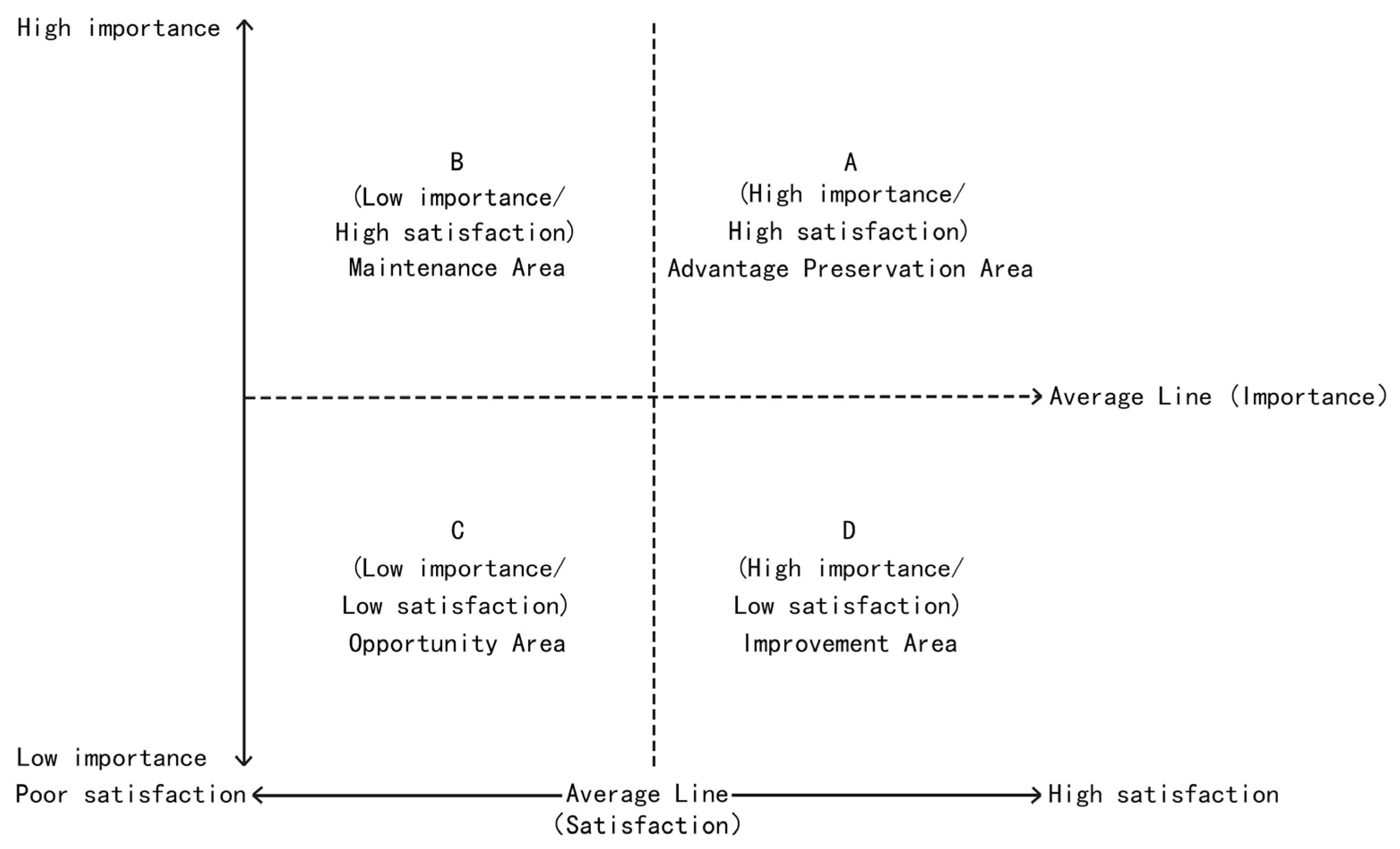
20]. In IPA, with importance as the horizontal axis and satisfaction as the vertical axis, and the two-dimensional mean as the coordinate origin, four quadrants can be formed (
Figure 3): Quadrant A (Advantage Preservation Area) indicates that both the importance and satisfaction of the elements are above the mean, suggesting that these elements need to be maintained and improved; Quadrant B (Maintenance Area) indicates low importance but high satisfaction, reflecting possible redundancy in resource investment; Quadrant C (Opportunity Area) corresponds to factors with low importance and low satisfaction, which can be temporarily deprioritized when resources are limited; Quadrant D (Improvement Area) refers to elements with high importance but low satisfaction, representing a key area that should be prioritized for subsequent optimization.
3.2. Data Scale
Core data of the sample settlements—including plot texture, natural elements, public spaces, and building styles—were obtained by the research team through field surveys and digital survey methods from 15 March to 25 September 2025. Qualitative data on cultural context, historical elements, primitive totems, and other intangible spatial attributes were collected by the research group through survey questionnaires, in-depth interviews, policy and case texts, and literature materials during two periods: 30 September to 31 October 2025, and 3 November to 29 November 2025 (
Table 1).
Given the large volume of data concerning the 26 traditional settlements, this study encountered instances of both partial and complete data missingness. Therefore, based on the characteristics of the data itself, linear interpolation was used to estimate specific missing values for partially missing data. For completely missing data, the average value of the corresponding indicator across the other traditional settlements was used as the indicator value for the settlement in question.
4. Indicators Selection and Data Analysis
4.1. Indicators Selection
The criteria for selecting these 18 evaluation indicators are as follows: first, using the nationally recognized and officially issued Evaluation Indicator System for China’s Historic and Cultural Towns (Settlements) (Trial) and Evaluation and Certification Indicator System for Traditional Settlements (Trial) as the primary references; second, systematically reviewing relevant literature in the field of spatial perception evaluation and conducting a comprehensive analysis; third, integrating the actual characteristics of traditional settlements in the West Liao River Basin with the results of the survey questionnaires. Based on these criteria, 18 perception-based indicators capable of reflecting the spatial characteristics of these settlements while balancing assessments of importance and satisfaction were ultimately identified. This study selected core indicators with comparability, directionality, and operability across four dimensions: site selection, spatial construction, buildings and small-scale components, and intangible culture. Through systematic integration, a three-level “scheme–criterion–indicator” evaluation system for spatial perception elements of traditional settlements was constructed, encompassing 4 criteria and 18 specific indicators (
Table 2). Based on the classification criteria, the original data was dimensionless processed using the standardization model of SPSS 22.0 software. The resulting standardized results are shown in
Tables S1 and S2.
4.2. Questionnaire Survey
This study focuses on the core components of spatial perception in the West Liao River Basin. Using random sampling, a survey was conducted across the basin to assess the importance of these components, and the results were used to rank them in order of importance. Based on these findings, the component system was screened and refined, ultimately establishing an indicator system suitable for the analysis and evaluation of spatial perception in the West Liao River Basin. The elements of the aforementioned indicator system were translated into colloquial language and adapted to create separate satisfaction survey checklists tailored to two distinct groups: out-of-town visitors and local residents. A five-point Likert scale (1 = not at all important/not at all satisfied; 5 = very important/very satisfied) was used to quantitatively measure the importance and satisfaction levels associated with the 18 spatial perception elements. First, respondents rated the importance of each element based on their subjective perceptions; second, the same scale was used to measure satisfaction with the current status of each element, thereby reflecting the public’s level of recognition of the current effectiveness of spatial conservation efforts.
This study employed a hybrid questionnaire distribution strategy, combining on-site random sampling and targeted online push notifications (
Table 3). Through in-person interviews, 832 questionnaires were distributed and collected in traditional settlements within the West Liao River Basin, achieving a 100% response rate. Additionally, due to the low level of tourism development in these settlements, obtaining visitor samples was challenging. Therefore, electronic questionnaires were distributed via QQ, WeChat, and Weibo, focusing on tourist groups. A total of 3952 questionnaires were distributed and fully recovered. After data cleaning and the removal of 264 invalid responses, the final valid sample size was 3688, yielding an effective response rate of 93.33%.
4.3. Data Analysis
4.3.1. Reliability and Validity Analysis
- (1)
Reliability analysis
Reliability refers to the extent to which a measuring instrument can consistently reproduce results under identical conditions, irrespective of testing time, location, or the individual administering the test. This research employed Cronbach’s alpha coefficient to assess the reliability of the importance and satisfaction data for perceived elements of traditional settlement spatial characteristics in the West Liaohe River Basin (Equation (1)).
This research employed Cronbach’s alpha coefficient to assess the reliability of the scale. The importance and satisfaction evaluation data for traditional settlement spatial perception elements in the Xiliao River Basin were imported into SPSS 22.0. The analysis results indicated that the alpha coefficient for the importance evaluation was 0.912 and for the satisfaction evaluation was 0.953. Both coefficients significantly exceeded the benchmark threshold of 0.9, demonstrating that the scale exhibits extremely high internal consistency and reliable data (
Table 4).
- (2)
Normality Analysis
The Shapiro–Wilk test was used to assess the normality of the data. The results showed that the test statistic W = 0.95000 (n = 26,
p = 0.247 > 0.05), and the null hypothesis of normality could not be rejected, indicating that the data follow a normal distribution. Therefore, the data satisfy the assumptions of Bartlett’s sphericity test (
Table 5).
- (3)
Validity analysis
Regarding structural validity, the importance and satisfaction evaluation data of traditional settlement spatial perception elements in the West Liaohe River Basin were imported into SPSS 22.0 for analysis. The KMO test value was 0.846 (greater than 0.7), and the Bartlett sphericity test yielded a significance level of 0.000, indicating that the scale possesses good construct validity and is suitable for subsequent analysis (
Table 6).
4.3.2. Descriptive Statistical Analysis
- (1)
Sample demographic analysis
This research is based on sample demographic survey data, analyzed across five dimensions: gender, age, education level, monthly income, and local resident identity. The results are presented in
Table 7, and based on these results, the demographic characteristics of the sample are systematically sorted and explained.
Gender
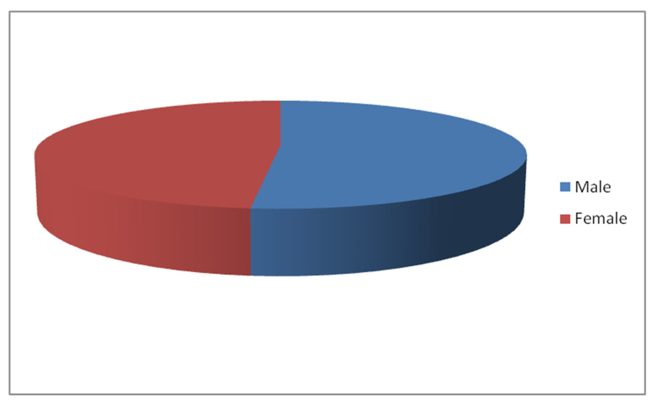
The gender structure analysis of 4784 respondents revealed that males constituted 51.6% (2470 individuals) and females constituted 48.4% (2314 individuals), resulting in a nearly balanced ratio between the two genders (see
Figure 4 for details). This distribution pattern indicates that the sample demonstrates strong representativeness in the gender dimension and is capable of effectively reflecting the structural characteristics of the target population.
Age
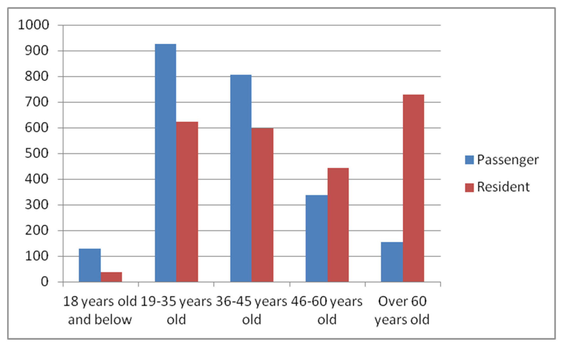
This survey employs a five-stage age grouping methodology (
Figure 5). Respondents are primarily aged 19–35 (33.2%) and 36–45 (29.3%), collectively accounting for over 50% of the total population. Only 2.7% (5 cases) of the population consists of individuals less than 18 years of age. The primary reasons for this distribution are as follows: migrant workers aged 19–35 exhibit a high level of concern for their hometowns and actively participate in online surveys; most individuals aged 36–45 have the financial means for tourism consumption. The remote settlement lacks basic educational infrastructure, leading minors to often accompany their parents during research trips and only participate in surveys when returning home during holidays.
Educational Level
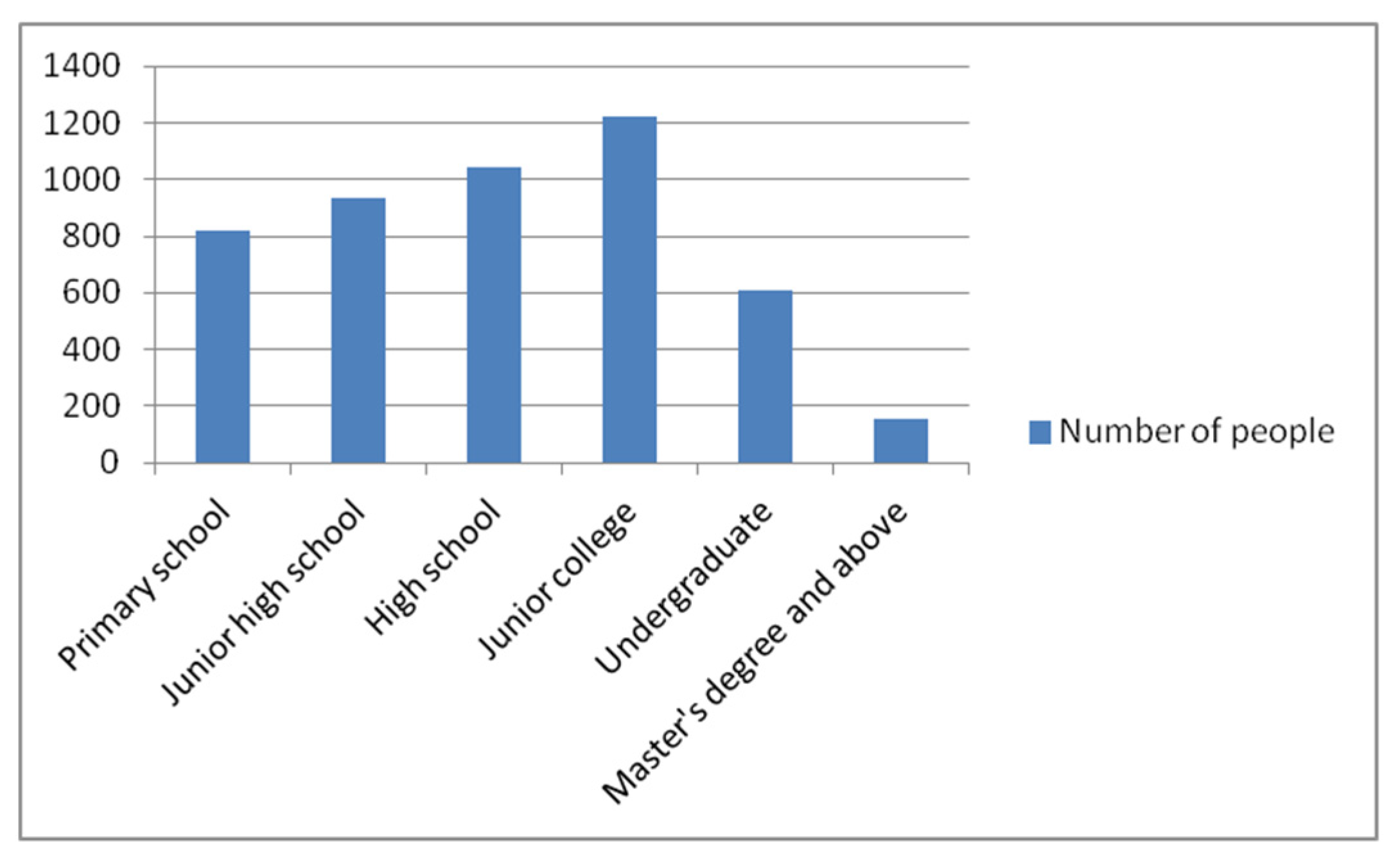
Based on the analysis of the respondents’ educational backgrounds (
Figure 6), the educational structure exhibits a pyramid distribution. Junior high school (21.74%), high school (25.54%), and Junior college (19.57%) constitute the primary segments, followed by primary school at 17.1%. In contrast, undergraduate (12.75%) and Master’s degree and above (3.3%) represent relatively lower proportions. This distribution is attributed to certain settlements being designated as ‘traditional settlements at the autonomous region level,’ which attract highly educated researchers to reside there, thereby forming local clusters.
Monthly Income
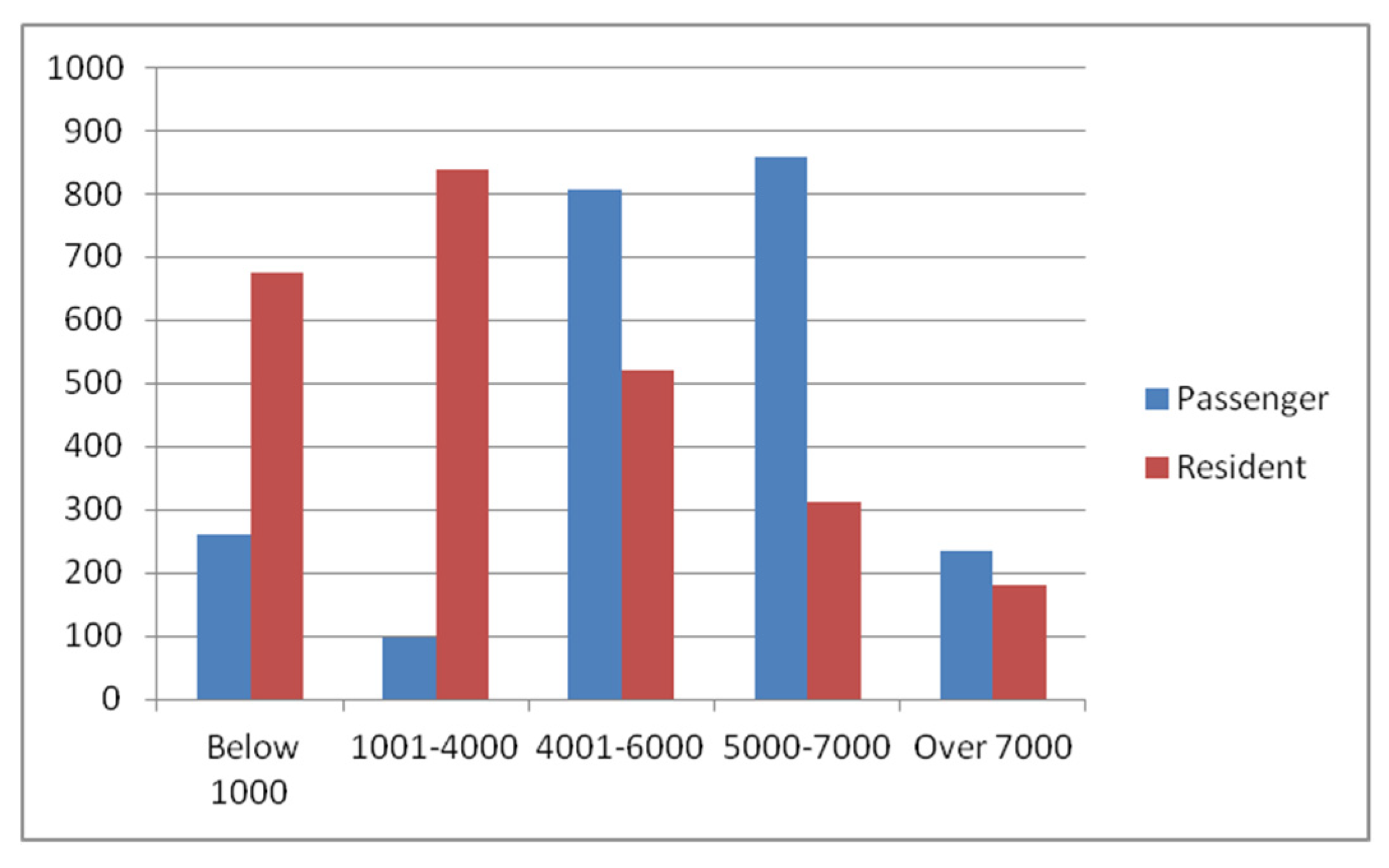
Based on empirical survey (
Figure 7), the income of permanent residents in the West Liaohe River Basin is concentrated below 3000 yuan, whereas the income range above 3000 yuan is primarily composed of foreign tourists. This differentiation reflects the industrial contradictions inherent in traditional settlements: on one hand, settlements rely on low-value-added livelihoods such as traditional farming, grazing, and migrant work, resulting in low incomes; on the other hand, the gathering place is situated in a remote area with inconvenient transportation (only a few shuttle buses connect it to the county town), while high-income tourists typically choose to travel by car. The root cause lies in the lack of endogenous driving force in the modernization transformation of settlements and the unsmooth introduction of external resources.
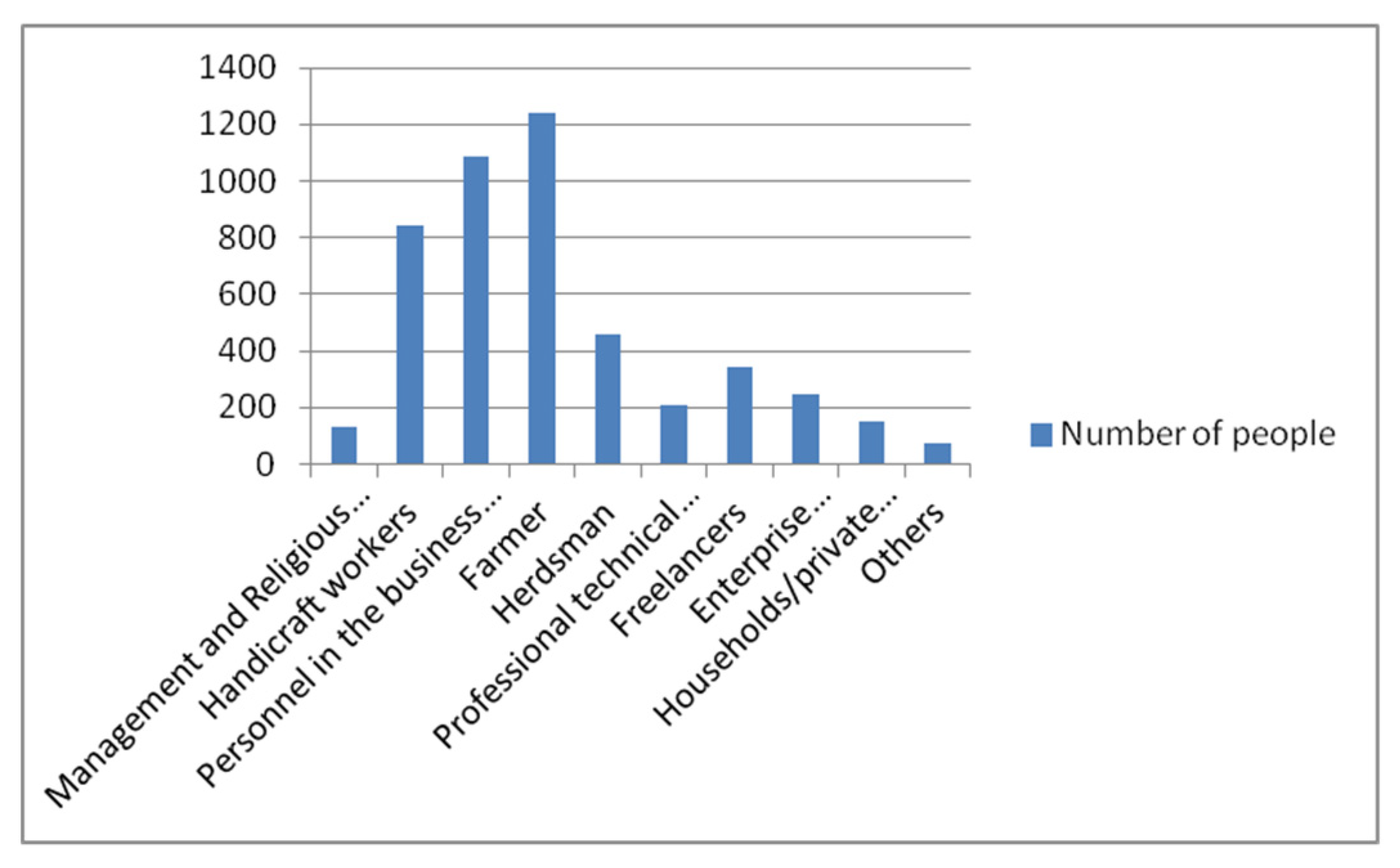
Occupational Type
As illustrated in
Figure 8, the respondents exhibit a significantly uneven occupational composition. Farmers and herdsmen constitute the largest proportion, followed by freelancers, individual industrial and commercial households/private enterprise owners, professional and technical personnel, enterprise employees, and civil servants/public institution staff. In contrast, the proportions of retirees and workers are relatively low. This occupational distribution pattern intuitively reflects that the overall employment status of this group is at a relatively low level, characterized by a significant lack of occupational stability, thereby highlighting the disadvantaged employment position of the respondents.
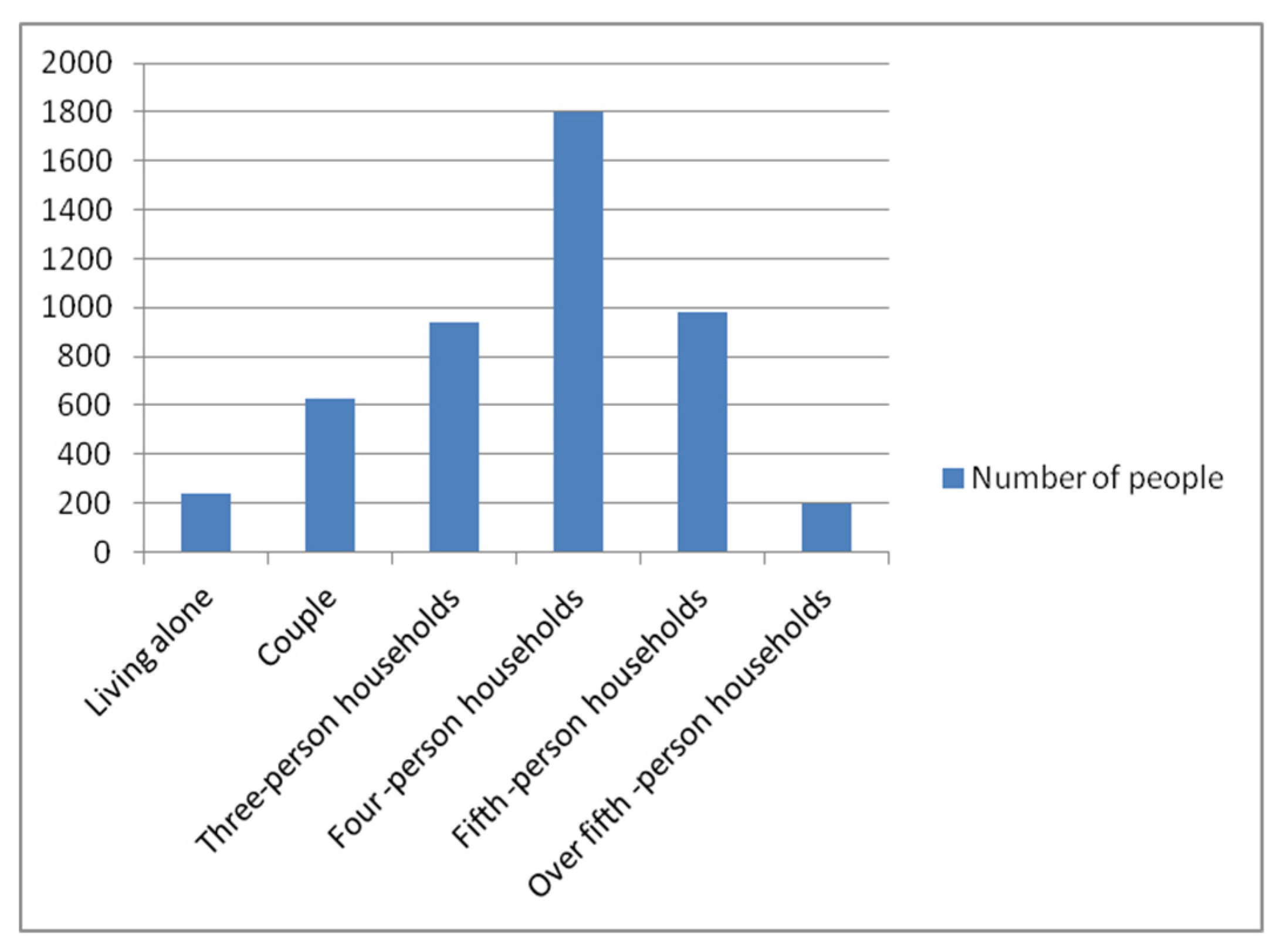
Family Size
According to the statistical analysis of the survey data (
Figure 9), there is a significant distribution pattern of nuclear family types within the respondents’ family structures. Among these, the primary family model consisting of a four-member household has the highest proportion, accounting for 37.6%. Next are five-member and three-member families, which account for 20.5% and 19.6%, respectively. The proportions of single-person households and households with five or more members in the sample are the lowest, at 9.2%. This distribution pattern reflects the demographic characteristics of traditional settlements dominated by medium-sized core families.
4.3.3. Perception Analysis of Spatial Characteristics
- (1)
Historical elements
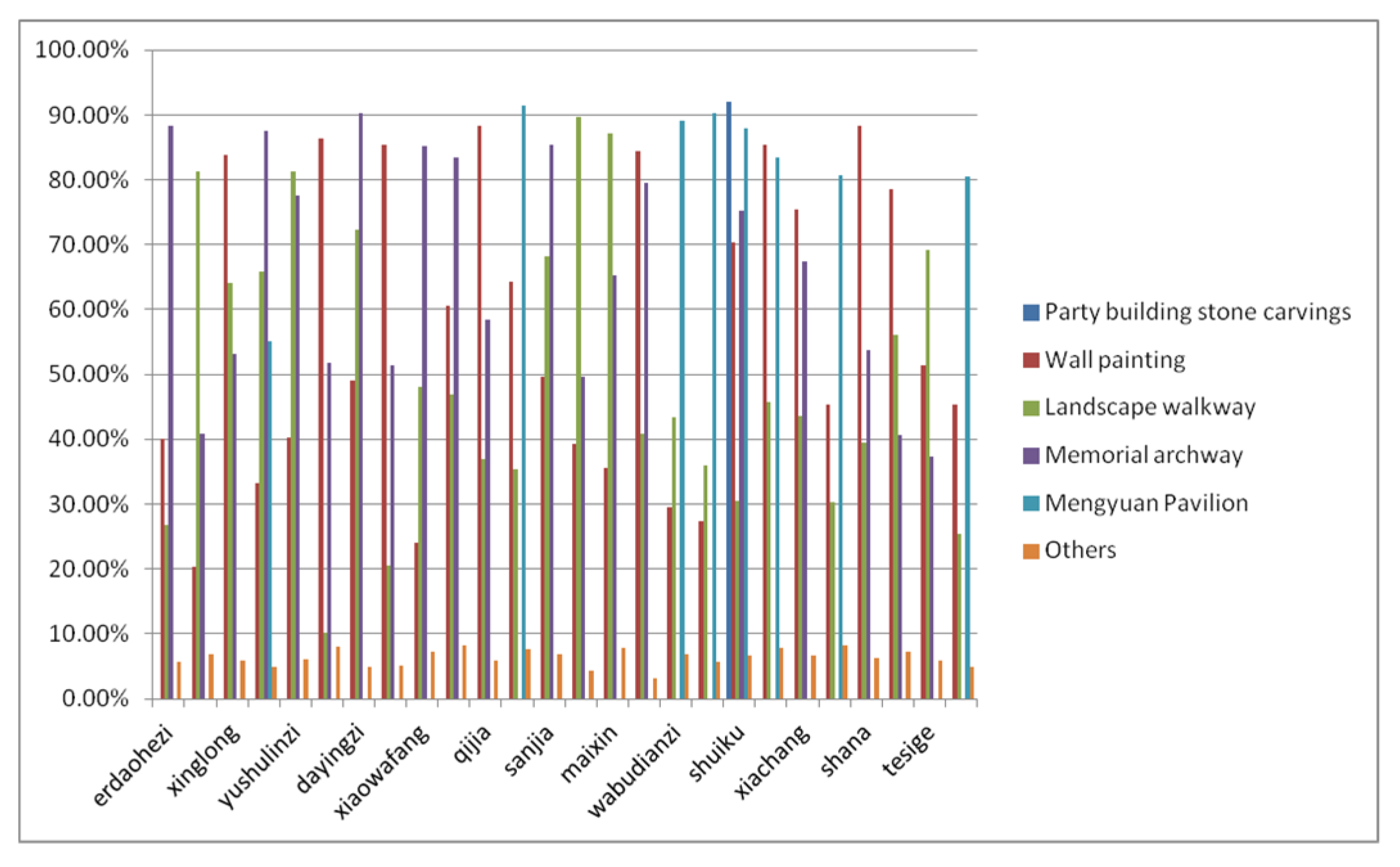
The historical element system of traditional settlements in the Xiliao River Basin comprises Party building stone carvings, Mengyuan Pavilion, wall paintings, landscape trails, and other components. Cultural identity surveys (
Figure 10) indicate that wall paintings have emerged as the most representative cultural symbol, with 85.75% recognition. This is followed by memorial archways (82.45%) and landscape footpaths (80.22%). In contrast, awareness of Mengyuan Pavilion and Party building stone carvings remains low, at 15.57% and 11.81%, respectively. Current protection efforts exhibit imbalance: while Party building stone carvings have been identified and marked, the protective system requires improvement. Mengyuan Pavilion’s cultural value has been recognized, yet certain sections have been abandoned and necessitate restoration for recreational purposes.
- (2)
Public Space
The public space system of traditional settlements in the Xiliao River Basin comprises multiple elements, including religious buildings, cultural facilities, commercial facilities, and leisure spaces. The cultural identity survey (
Figure 11) reveals that the settlement history museum and folk customs museum constitute the core memory carriers, while the settlement green spaces, farmhouse entertainment areas, and markets form the secondary cognitive circle. The entrance square, Aobao, and mosque are positioned on the perceptual edge. The settlement history museum and folk customs museum have emerged as historical and cultural landmarks due to their role in preserving historical memory and ethnic cultural heritage. Settlement green spaces serve dual functions of communication and production. The entrance plaza suffers from inadequate signage and maintenance, resulting in low public awareness and necessitating urgent revitalization and protection efforts.
- (3)
Building Features survey
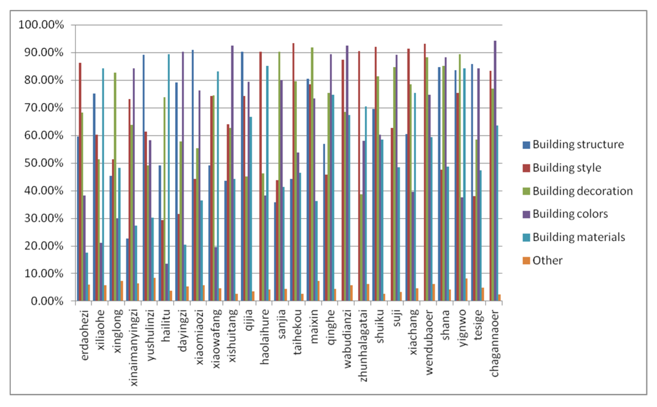
The building characteristics of traditional settlements in the West Liao River Basin exhibit distinct regional features, with their value carriers encompassing five dimensions: building style, material, structure, color, and decoration. Spatial perception surveys (
Figure 12) indicate that building style has the highest recognition rate as a cultural symbol, at 86.47%. Building structure, decoration, and materials have also received high praise for their effectiveness in adapting to terrain and climate (all exceeding 80%). However, awareness of building color is relatively low, at 37.9%. This gradient reveals the attenuation pattern of the spatial characteristic value of material carriers.
- (4)
Current situation of space characteristic protection
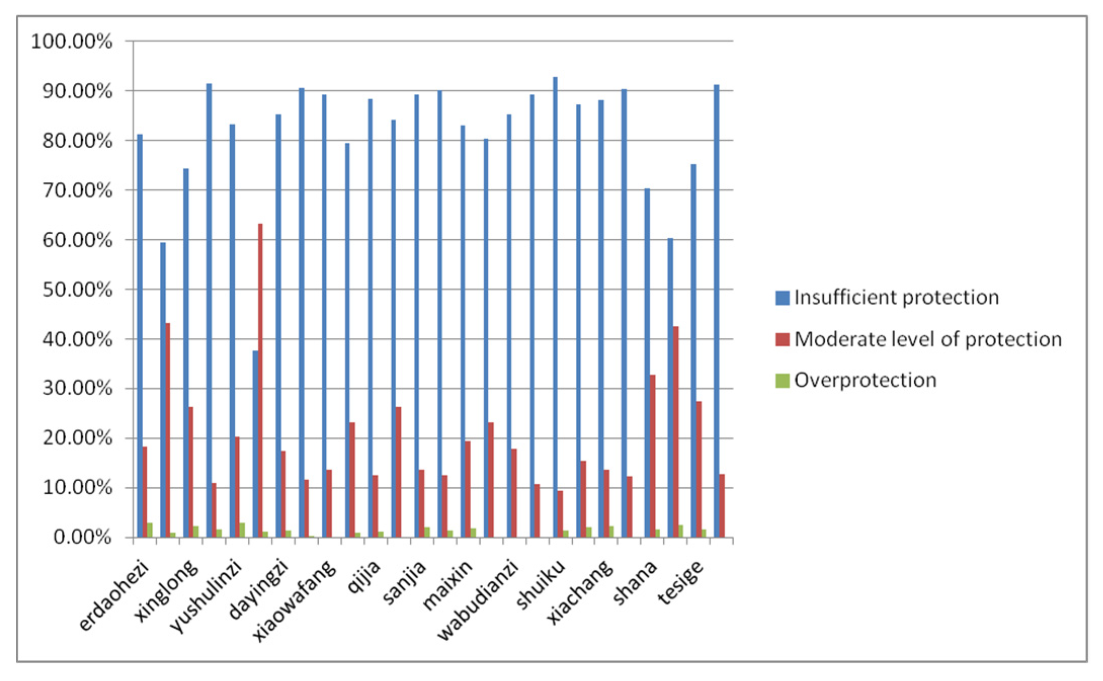
The protection status of traditional settlements in the West Liao River Basin has resulted in significant differences (
Figure 13). A total of 81.35% of respondents indicated that current protection measures exhibit obvious deficiencies and that there is an urgent need to strengthen systematic protection. A total of 18.33% of respondents believe that the current level of protection aligns with the present condition of the settlements and advocate maintaining the status quo to avoid excessive intervention. An additional 2.86% of respondents proposed following the laws of natural development and reducing human investment, taking into account practical factors such as settlement remoteness, economic underdevelopment, and weak infrastructure.
4.3.4. Importance and Satisfaction Analysis
- (1)
Importance Analysis
According to
Table 8, the average importance rating of perceived elements of traditional settlement spatial characteristics in the West Liao River Basin exceeds the theoretical median, indicating a high degree of consensus among respondents. Among these elements, intangible cultural and macro-spatial components—such as cultural context, central form, and plot texture—are particularly prominent and rank among the highest in importance. In contrast, specific material space components, including building decoration, water landscape, and ground paving, have relatively low importance. Based on primitive totems, two cognitive levels have been identified: high importance and medium-high importance.
- (2)
Satisfaction Analysis
As shown in
Table 9, the average satisfaction evaluation of traditional settlement spatial characteristics perception elements in the West Liaohe River Basin ranges from 3.12 to 4.66, with significant actual perception differences among respondents. Natural elements and spatial nodes fall within the highly expressive zone (mean > 4.45), exhibiting the most prominent perception. Public spaces related to water landscapes belong to the medium expressive zone (3.42–4.36), demonstrating moderate recognition. Building decoration and building materials are categorized in the low expressive zone (mean < 3.42), where perception of building materials is notably insufficient. The standard deviation for each element is relatively small (0.753–0.988), indicating high data reliability.
4.3.5. Paired Sample T-Test
Table 10 reveals a significant and negative gap between the expected importance and actual satisfaction of the 18 indicators at the 0.01 significance level. This indicates a substantial discrepancy between respondents’ cognitive expectations and their perception of reality. The settlement space has not fully met social expectations regarding inheritance and perceptual experience, and there is a general lack of systematic awareness of various elements, suggesting considerable room for optimization. From a system integration perspective, future efforts should focus on the overall strengthening and collaborative enhancement of spatial characteristics.
5. Results
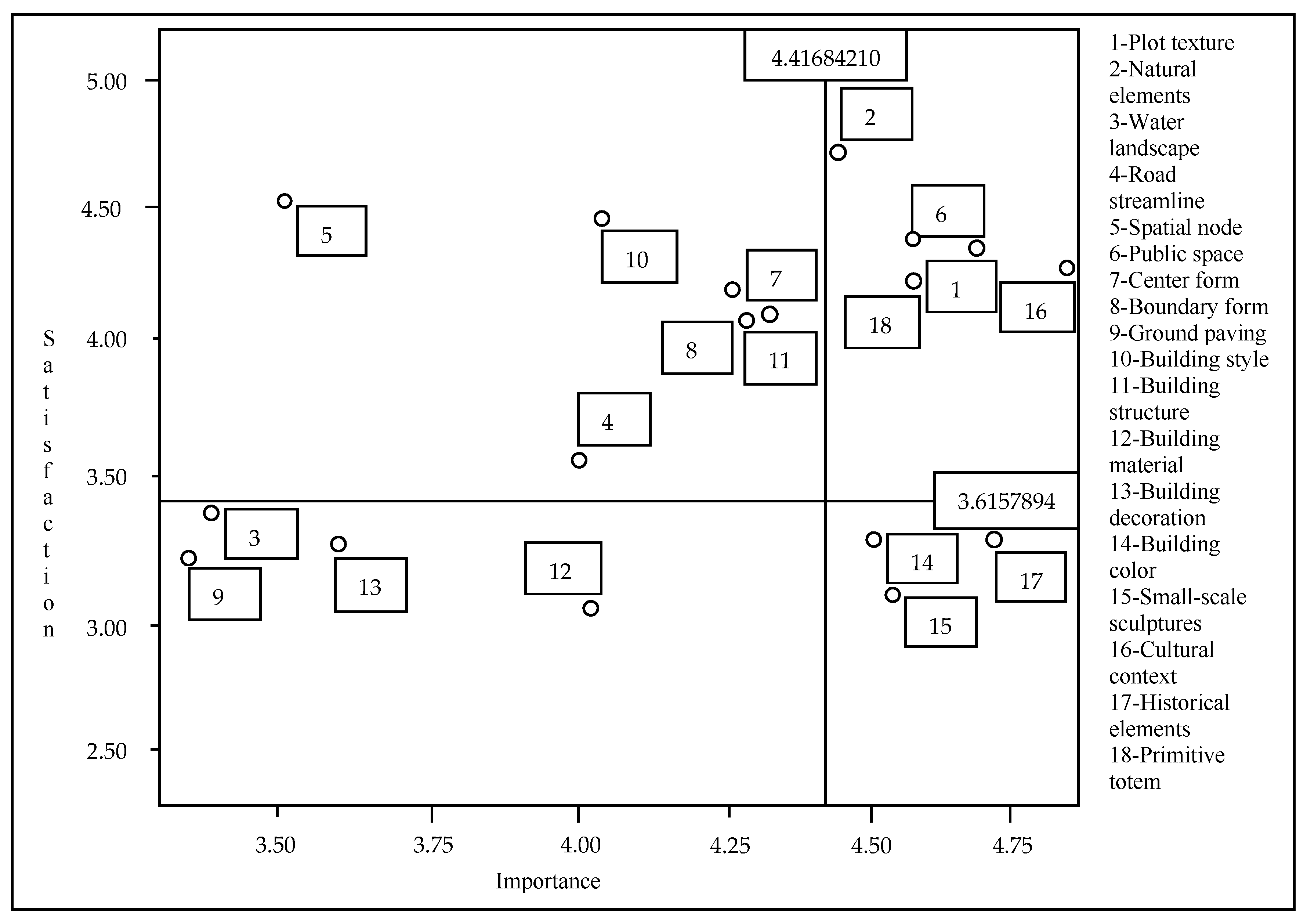
This research adopts the IPA framework, with an importance mean of 4.42 as the
X-axis and a satisfaction mean of 3.62 as the
Y-axis, to divide 18 perceived elements into four quadrants (
Figure 14) to clarify management optimization priorities.
Based on the IPA quadrant division results, the spatial perception elements of traditional settlements in the West Liao River Basin can be categorized into four types, each corresponding to differentiated protection strategies. The “Advantage Preservation Area” (natural elements, original totems, public spaces, cultural context, and plot texture) in the first quadrant exhibits high importance and high satisfaction. It should be consolidated as a strategic pivot for maintaining cultural authenticity and settlement symbiosis. The “Maintenance Area” (spatial nodes, central forms, boundary forms, building styles, building structures, and road flow lines) in the second quadrant has higher satisfaction than importance. It is recommended to dynamically update these areas while maintaining the current situation, in conjunction with overall protection. The “Opportunity Area” in the third quadrant (water landscape, building decoration, ground paving, and building materials) is characterized by low importance and low satisfaction, facing the issue of disappearing appearance. A “moderate maintenance” strategy is advisable, with potential activation through the revival of traditional materials. The fourth quadrant, the “Improvement Area” (historical elements, building color, and building details), presents a significant gap characterized by high importance paired with low satisfaction. It is urgent to transform this area into a core asset for sustainable development through comprehensive measures such as spatial revitalization and style control.
6. Discussions
Although certain innovative achievements have been attained, this research remains subject to limitations, which are outlined as follows: 1. Research Methodology. (1) The requirement for accurate measurement of case characteristics hinders the acquisition of in-depth information and may lead to overlooking the specific change process. (2) The complexity of the current spatial context of traditional settlements complicates the precise determination of causal relationships among numerous variables. (3) Traditional Chinese settlements exhibit unique spatial perceptions that resist generalization; thus, quantitative analysis alone is insufficient. 2. Data Accuracy. Given the substantial volume of data from 26 traditional settlements, this research encountered both partial and complete data missingness, resulting in compromised data accuracy. 3. Analytical Strategies. Subjective bias was present during the survey process.
This study concludes that the identified limitations do not fundamentally undermine the reliability of the findings; rather, they primarily affect the precision of the results and the scope of their generalizability. Notably, subjective bias has been transformed into a strength of the study, as residents’ subjective evaluations are central to research on spatial perception.
To address these limitations, the study implemented the following measures: Cronbach’s α > 0.7 and the KMO statistic > 0.6 were used to ensure reliability and validity; paired-sample t-tests were employed to verify the significance of differences; a large sample size (26 settlements) was utilized to mitigate the impact of extreme preferences; and missing data were handled using listwise deletion and mean imputation. In summary, the conclusions possess sufficient validity and robustness.
The contradiction between the “high importance” and “low satisfaction” of historical elements stems from the “invisibility” and “marginalization” of key sub-elements—such as the Mengyuan Hall and the Party-building stone carvings—in spatial perception. This is reflected in extremely low public awareness (only 15.57% and 11.81%, respectively) and a lack of functional and narrative coherence. Current strategies, which prioritize “preservation” over “perception,” make it difficult for the public to have a meaningful spatial experience. Therefore, the key to improving satisfaction lies in “reactivating” the spatial perception of these high-value elements through measures such as restoring their functions and enhancing landscape coherence.
In the evaluation of spatial perception in traditional settlements, local residents and tourists are selected as the target groups rather than categorizing individuals based on residency status, because the research focuses on actual patterns of human–space interaction: residents provide functional and emotional perceptions based on long-term living, whereas tourists offer aesthetic and atmospheric perceptions based on brief experiences. Residency status (e.g., type of household registration) primarily reflects legal affiliation and has no direct correlation with the depth or quality of spatial perception. Furthermore, it is prone to include individuals who do not actually reside in the area or those who are merely passing through, making it unsuitable as a basis for evaluation.
Local residents and tourists each accounted for nearly half of the sample (52.8% vs. 47.2%), primarily due to the study’s deliberate balancing strategy and the multifunctional characteristics of the settlements. Traditional settlements serve as both living spaces for residents and cultural destinations for tourists; these two groups exhibit significant differences in their perceptions of historical elements. Balanced sampling helps comprehensively capture these differing perspectives and ensures the statistical validity of subsequent comparative analyses. Furthermore, the survey period was scheduled to coincide with the peak tourist season and public holidays, naturally resulting in a balanced distribution of residents and visitors. This accurately reflects the “residential–tourism” mixed social structure of the settlements.
7. Conclusions
This study employs the Importance–Satisfaction Analysis (IPA) method to identify 18 evaluation factors based on the perceived dimensions of spatial characteristics in traditional settlements within the West Liao River Basin. Through quantitative analyses—including reliability and validity tests, descriptive statistics, and paired-sample t-tests—the factors were categorized into four groups: strength preservation areas, potential overkill areas, low-priority areas, and areas in urgent need of improvement. Based on these findings, differentiated strategies are proposed: in the advantage preservation area, cultural narratives and spatial experiences should be reinforced to consolidate regional identity; in the maintenance area, dynamic maintenance and functional integration should be adopted to avoid excessive intervention; in the opportunity area, potential value should be activated through the revival of traditional materials and landscape restoration; and in the improvement area, targeted interventions should be implemented, combining spatial revitalization, visual character management, and the transmission of traditional crafts to restore cultural expression functions and promote the transition of settlements from static preservation to dynamic transmission.
Furthermore, the study revealed the spatial perception characteristics and cognitive logic of local residents, indicating that their perceptions are actively constructed based on daily life, intergenerational experiences, and cultural practices, exhibiting the dual characteristics of “place dependence” and “path orientation.” Core sites (such as ancient wells and ancestral halls) serve as anchors of local identity, while the alleys traversed daily and boundary nodes constitute the basic units of evaluation. Residents’ judgments of “importance” emphasize social memory and functional utility, whereas their assessments of “satisfaction” depend on the state of spatial maintenance and environmental comfort. Elements identified in the IPA as “areas in urgent need of improvement”—those with high importance but low satisfaction—reflect residents’ “cultural anxiety” and “sense of spatial loss.” Therefore, residents’ spatial perceptions serve not only as the experiential foundation for evaluating settlements but also as a key reference for shifting strategies from “expert-led” to “community-driven” approaches. Moving forward, residents’ cognitive patterns should be fully incorporated to establish a dynamic conservation approach anchored in daily practices and cultural memory.
Supplementary Materials
The following supporting information can be downloaded at:
https://www.mdpi.com/article/10.3390/buildings16091657/s1, Table S1: Standard Value of Evaluation Indicators for Spatial Perception Factors of Traditional Settlements in the West Liaohe River Basin (Part 1); Table S2: Standard Value of Evaluation Indicators for Spatial Perception Factors of Traditional Settlements in the West Liaohe River Basin (Part 2).
Author Contributions
Conceptualization, J.L. (Jiajing Li) and J.L. (Jianing Li); methodology, J.L. (Jianing Li); software, J.L. (Jianing Li); validation, J.L. (Jiajing Li); formal analysis, J.L. (Jiajing Li) and J.L. (Jianing Li); survey, J.L. (Jiajing Li); resources, P.Z.; data curation, J.L. (Jiajing Li) and J.L. (Jianing Li); writing—original draft preparation, J.L. (Jianing Li); writing—review and editing, J.L. (Jiajing Li); visualization, J.L. (Jiajing Li) and J.L. (Jianing Li); supervision, P.Z.; project administration, P.Z.; funding acquisition, P.Z. All authors have read and agreed to the published version of the manuscript.
Funding
This research was funded by [Research on the Evolution Mechanism and Coordinated Planning Methods of ‘Three-Living Spaces’ in Settlements Areas of Urban Agglomerations in Northwest China] grant number [No. 52378076]. The APC was funded by [National Natural Science Foundation General Program, Natural Science Foundation, China].
Institutional Review Board Statement
Ethical review and approval were waived for this study because there are no risks associated with participating in this study. The core scope of ethical review applies to life science and medical research involving human subjects or their biological samples and data. The “Measures for Ethical Review of Life Science and Medical Research Involving Human Subjects,” jointly issued by relevant national authorities, clearly defines its jurisdiction as research activities that use human subjects as participants or utilize their samples and data. The evaluation of spatial perception elements in traditional settlements primarily focuses on both tangible and intangible cultural aspects, such as spatial patterns, landscape features, and cultural contexts. Research methods typically include field surveys (primarily observing the physical environment). Since this type of research does not directly treat specific individuals as subjects and does not collect or analyze sensitive personal information such as health records or behavioral data, it does not fall within the scope of research requiring ethical review as defined by the “Measures”.
Informed Consent Statement
Informed consent was obtained from all subjects involved in the study.
Data Availability Statement
As the data involves one years of local policies, management, financial audits, participation of multiple interest subjects, and other more sensitive information, it is internal information and cannot be made public according to local requirements.
Conflicts of Interest
The authors declare no conflicts of interest.
References
- Duan, H.; Zhang, P.; Zhang, Z. Research on Optimization Strategies for Old City Garden Space Based on Importance Satisfaction Analysis: A Case Research of Mingcheng District, Xi’an. Huazhong Archit. 2021, 39, 101–105. [Google Scholar] [CrossRef]
- Zhang, G. Research on the Continuation Strategy of Urban Characteristics and Scenery in the Old Town of Ankang City; Xi’an Northwest University: Xi’an, China, 2020. [Google Scholar] [CrossRef]
- Zhu, W.; Meng, J.; Fang, Z.; Zhang, Y.; Zheng, W. Research on the Perception and Optimization Path of Tourism Image of Typical Traditional Settlements in the Lijiang River Basin Based on UGC Data and IPA Model. Landsc. Archit. 2025, 42, 62–69. [Google Scholar]
- Zhang, Y.; Zhang, B.; Tang, F. Perception and Optimization Strategies of Settlement Public Space Landscape Based on Place Attachment: A Case Research of Jiaoyuan Settlement in Zhaoqing City. Smart Agric. Guide 2025, 5, 34–38+43. [Google Scholar] [CrossRef]
- Zhang, S.; Liu, D.; Du, S.; Zhou, L. Research on spatial perception of traditional Settlements based on UGC data—Taking Tangmo Settlement, Mount Huangshan City as an example. J. Cent. China Norm. Univ. (Nat. Sci. Ed.) 2024, 58, 688–699. [Google Scholar] [CrossRef]
- Yu, H.; Duan, Y. Perception and Enhancement Strategies of Traditional Settlement Public Spaces from the Perspective of Cultural Tourism Integration. J. Xi’an Univ. Archit. Technol. (Soc. Sci. Ed.) 2023, 42, 70–77+84. [Google Scholar] [CrossRef]
- Chang, F. Spatial Perception of Settlement and Town Residents in Dujiangyan Irrigation Project City. J. Mt. Reg. 2012, 30, 401–407. [Google Scholar] [CrossRef]
- Zhou, J.; Hua, C.; Xia, X.; Wu, S. Research on the Perception of Traditional Settlement Cultural Space Based on Network Text Content Analysis: A Case Research of Qiantong Ancient Town in Zhejiang Province. Huazhong Archit. 2022, 40, 108–112. [Google Scholar] [CrossRef]
- Li, N.; Zhang, J. Spatial differentiation of landscape changes of traditional settlement buildings in tourist destinations—A case research of Jiuzhaigou Valley Scenic and Historic Interest Area based on public perception. J. Suzhou Univ. (Philos. Soc. Sci. Ed.) 2009, 30, 131–133. [Google Scholar] [CrossRef]
- Wang, W.; Wang, Y.; Fang, S. Construction of a measurement model for the sense of justice in the tourism space of ancient Settlements based on property rights exchange. Tour. Trib. 2023, 38, 28–40. [Google Scholar] [CrossRef]
- Zhang, X.; Xiong, X.; Chi, M.; Yang, S.; Liu, L. Research on visual quality assessment and landscape elements influence mechanism of settlement greenways. Ecol. Indic. 2024, 160, 111844–111854. [Google Scholar] [CrossRef]
- Wang, Y.; Qi, L.; Zhou, X.; Lin, H.; Wu, W. Parameterized evaluation of spatial quality of tourism oriented streets and alleys in Shawan Ancient Town, Guangzhou from the perspective of spatial perception. Archit. Cult. 2025, 197–198. [Google Scholar] [CrossRef]
- Wei, Y.; Chen, Z. Research on the Quality Evaluation System of Traditional Settlement Street Space in Mentougou District. Urban Archit. 2024, 21, 43–46. [Google Scholar] [CrossRef]
- Liu, R.; Tao, Z.; Li, T. Research on Tourist Perception of Characteristics of Settlement Landscape Resources: A Case Research of Dawei Town, Hefei. J. Cent. South Univ. For. Technol. (Soc. Sci. Ed.) 2016, 10, 54–60. [Google Scholar] [CrossRef]
- Tong, H.; Xiao, R.; Cheng, J. Research on the Impact of Traditional Settlement Spatial Genetic Perception on Tourist Satisfaction: A Case Research of Xiongcun, Shexian County. Anhui Archit. 2023, 30, 12–15+29. [Google Scholar] [CrossRef]
- Liu, R.; Liu, P.; Shen, X.; Zhou, W. A Research on the Role of Traditional Settlement Landscape Genes in Tourism Image Construction: A Case Research of Zhangguying Settlement. J. Resour. Ecol. 2024, 15, 587–600. [Google Scholar]
- Chen, T.; Zhou, K. Research on Traditional Settlement Landscape Gene Evaluation Based on the “Cell Chain Shape” Correction Model: A Case Research of Songgucheng Settlement. For. Ecol. Sci. 2025, 40, 209–219. [Google Scholar] [CrossRef]
- Han, M.; Zhang, Y.; Fang, C.; Zhao, Y. The selection of settlement environment and the relationship between human and land in the West Liaohe River Basin since the Holocene. Geogr. Res. 2008, 1118–1128. [Google Scholar]
- Han, M.; Liu, X.; Fang, C.; Zhang, Y.; Li, Q.; Zhao, Y. Site selection and environmental interpretation of settlements in the middle Holocene West Liaohe River Basin. Acta Geogr. J. 2007, 62, 1287–1298. [Google Scholar]
- Chen, X. Research on the Renewal Strategy of Age friendly Landscape in Old Communities Based on IPA Analysis Method; Chengdu Southwest Jiaotong University: Chengdu, China, 2020. [Google Scholar] [CrossRef]
Figure 1.
Geographical Location Map of the West Liaohe River Basin.
Figure 1.
Geographical Location Map of the West Liaohe River Basin.
Figure 2.
Distribution of Traditional Settlements under Key Research in the West Liaohe River Basin.
Figure 2.
Distribution of Traditional Settlements under Key Research in the West Liaohe River Basin.
Figure 3.
Schematic diagram of IPA method.
Figure 3.
Schematic diagram of IPA method.
Figure 4.
Gender Distribution Map.
Figure 4.
Gender Distribution Map.
Figure 5.
Age distribution chart.
Figure 5.
Age distribution chart.
Figure 6.
Distribution of Educational Level.
Figure 6.
Distribution of Educational Level.
Figure 7.
Income Distribution in June.
Figure 7.
Income Distribution in June.
Figure 8.
Distribution of Occupational Types.
Figure 8.
Distribution of Occupational Types.
Figure 9.
Distribution of Family Size.
Figure 9.
Distribution of Family Size.
Figure 10.
Statistical Table of Respondents’ Perception of Historical Factors.
Figure 10.
Statistical Table of Respondents’ Perception of Historical Factors.
Figure 11.
Statistical Table of Respondents’ Perception of Public Spaces.
Figure 11.
Statistical Table of Respondents’ Perception of Public Spaces.
Figure 12.
Statistical Table of Respondents’ Perception of Building Features.
Figure 12.
Statistical Table of Respondents’ Perception of Building Features.
Figure 13.
Statistical Table of Respondents’ Perception of Settlement Protection Status.
Figure 13.
Statistical Table of Respondents’ Perception of Settlement Protection Status.
Figure 14.
IPA grid diagram of traditional settlement spatial characteristics perception elements in the West Liaohe River Basin. Image source: Organized and analyzed using SPSS 22.0 software.
Figure 14.
IPA grid diagram of traditional settlement spatial characteristics perception elements in the West Liaohe River Basin. Image source: Organized and analyzed using SPSS 22.0 software.
Table 1.
Data Scale Characteristics of Traditional settlements in the West Liaohe River Basin.
Table 1.
Data Scale Characteristics of Traditional settlements in the West Liaohe River Basin.
| Data Type | Specific Scale |
|---|
| In-depth interviews (Survey questionnaires, interviews) | Survey questionnaires + 192 interviews, totaling 4784 |
| Policy and Case Text | 38–72 copies |
| literature | 12 news reports, 26 archival records, 4 research papers, 7 letter manuscripts, 26 historical documents, and 8 related travelogues, totaling 83 copies |
| 26 traditional settlement spatial locations | 6819–8155 pieces |
Table 2.
Spatial Perception Factors of Traditional Settlements in the West Liaohe River Basin.
Table 2.
Spatial Perception Factors of Traditional Settlements in the West Liaohe River Basin.
| Scheme Layer | Criterion Layer | Indicator Level |
|---|
| The spatial perception elements of traditional settlements (P) | Site selection (P1) | Plot texture (A1) |
| | Natural elements (A2) |
| | Water landscape (A3) |
| Space Construction (P2) | Road streamline (A4) |
| | Space node (A5) |
| | Public space (A6) |
| | Central form (A7) |
| | Boundary form (A8) |
| | Ground paving (A9) |
| Building and Accessories (P3) | Building style (A10) |
| | Building structure (A11) |
| | Building material (A12) |
| | Building decoration (A13) |
| | Building color (A14) |
| | Small-scale sculptures (A15) |
| Intangible Culture (P4) | Cultural context (A16) |
| | Historical elements (A17) |
| | Primitive totem (A18) |
Table 3.
Distribution and Collection of Survey Questionnaires.
Table 3.
Distribution and Collection of Survey Questionnaires.
| Distribution Method | Quantity Issued | Recycling Situation | Effective Recycling Situation |
|---|
| Recycled Quantity | Recovery Rate | Effective Recycling Quantity | Effective Recovery Rate |
|---|
| Field | 832 | 832 | 100.00% | 832 | 100.00% |
| Network | 3952 | 3688 | 93.33% | 3688 | 93.33% |
| Total | 4784 | 4520 | 94.48% | 4520 | 94.48% |
Table 4.
Reliability Analysis Table.
Table 4.
Reliability Analysis Table.
| Varies | Cronbach’s Alpha Coefficient | Number of Terms |
|---|
| Importance | 0.914 | 26 |
| Satisfaction | 0.955 | 26 |
Table 5.
Shapiro–Wilk Normality Test.
Table 5.
Shapiro–Wilk Normality Test.
| Test Methods | Test Statistic (W) | Sample Size
(n) | Significance
(p) | Conclusion on Normality |
|---|
| Shapiro–Wilk | 0.95000 | 26 | 0.247 | Follows a normal distribution |
Table 6.
KMO and Bartlett tests.
Table 6.
KMO and Bartlett tests.
| KMO sampling suitability quantity | | 0.847 |
| Bartlett’s sphericity test | Approximate chi-square | 8002.415 |
| | Degree of freedom | 706 |
| | salience | 0.000 |
Table 7.
Analysis of demographic characteristics of sample population.
Table 7.
Analysis of demographic characteristics of sample population.
| Varies Nature | Category | Frequency | Percentage (%) |
|---|
| Gender | Male | 2470 | 51.6 |
| | Female | 2314 | 48.4 |
| Age | 18 years old and below | 166 | 3.5 |
| | 19–35 years old | 1550 | 32.5 |
| | 36–45 years old | 1414 | 29.4 |
| | 46–60 years old | 775 | 16.2 |
| | over 60 years old | 879 | 18.4 |
| Educational level | Primary school | 818 | 17.1 |
| | Junior high school | 936 | 21.74 |
| | High school | 1040 | 25.54 |
| | Junior college | 1222 | 19.57 |
| | Undergraduate | 610 | 12.75 |
| | Master’s degree and above | 158 | 3.3 |
| Monthly income | Below 1000 | 834 | 17.4 |
| | 1001–3000 | 1038 | 21.7 |
| | 3001–5000 | 1346 | 28.2 |
| | 5000–7000 | 1140 | 23.8 |
| | Over 7000 | 426 | 8.9 |
| Occupation type | Management and Religious personnel | 130 | 2.7 |
| | Handicraft workers | 846 | 17.7 |
| | Personnel in the business and Service industries | 1086 | 22.7 |
| | Farmer | 1242 | 26 |
| | Herdsman | 458 | 9.6 |
| | Professional technical personnel | 210 | 4.4 |
| | Freelancers | 344 | 7.2 |
| | Enterprise employees/Individual industrial and commercial | 245 | 5.1 |
| | Households/Private enterprise households | 149 | 3.1 |
| | Others | 74 | 1.5 |
| Family size | Living alone | 237 | 5 |
| | Couple | 627 | 13.1 |
| | Three-person households | 939 | 19.6 |
| | Four-person households | 1797 | 37.6 |
| | Five-person households | 983 | 20.5 |
| | Over five-person households | 201 | 4.2 |
| Are you a local resident | Yes | 2527 | 52.8 |
| | No | 2257 | 47.2 |
Table 8.
Importance of Descriptive Statistics.
Table 8.
Importance of Descriptive Statistics.
| | N | Average Value (E) | Standard Deviation | Rank |
|---|
| A16 Cultural context | 4784 | 4.79 | 0.044 | 1 |
| A7 Center form | 4784 | 4.78 | 0.043 | 2 |
| A1 Plot texture | 4784 | 4.73 | 0.048 | 3 |
| A17 Historical elements | 4784 | 4.70 | 0.042 | 4 |
| A18 Primitive totem | 4784 | 4.62 | 0.051 | 5 |
| A6 Public space | 4784 | 4.59 | 0.049 | 6 |
| A15 Small-scale sculptures | 4784 | 4.54 | 0.045 | 7 |
| A14 Building color | 4784 | 4.51 | 0.055 | 8 |
| A2 Natural elements | 4784 | 4.46 | 0.044 | 9 |
| A11 Building structure | 4784 | 4.36 | 0.041 | 10 |
| A8 Boundary form | 4784 | 4.28 | 0.046 | 11 |
| A4 Road streamline | 4784 | 4.09 | 0.052 | 12 |
| A12 Building material | 4784 | 4.06 | 0.042 | 13 |
| A10 Building style | 4784 | 4.01 | 0.043 | 14 |
| A5 Spatial node | 4784 | 3.58 | 0.065 | 15 |
| A13 Building decoration | 4784 | 3.57 | 0.057 | 16 |
| A3 Water landscape | 4784 | 3.45 | 0.052 | 17 |
| A9 Ground paving | 4784 | 3.37 | 0.047 | 18 |
| Effective N (in columns) | 4784 | | | |
Table 9.
Mean ranking of satisfaction.
Table 9.
Mean ranking of satisfaction.
| | N | Average Value (E) | Rank | Standard Deviation |
|---|
| A2 Natural elements | 4784 | 4.66 | 1 | 0.988 |
| A5 Spatial node | 4784 | 4.52 | 2 | 0.808 |
| A6 Public space | 4784 | 4.36 | 3 | 0.762 |
| A10 Building style | 4784 | 4.34 | 4 | 0.753 |
| A1 Plot texture | 4784 | 4.31 | 5 | 0.866 |
| A16 Cultural context | 4784 | 4.29 | 6 | 0.764 |
| A18 Primitive totem | 4784 | 4.23 | 7 | 0.824 |
| A11 Building structure | 4784 | 4.17 | 8 | 0.768 |
| A7 Center form | 4784 | 4.14 | 9 | 0.796 |
| A8 Boundary form | 4784 | 4.12 | 10 | 0.861 |
| A4 Road streamline | 4784 | 3.56 | 11 | 0.922 |
| A3 Water landscape | 4784 | 3.42 | 12 | 0.859 |
| A13 Building decoration | 4784 | 3.38 | 13 | 0.897 |
| A17 Historical elements | 4784 | 3.31 | 14 | 0.849 |
| A14 Building color | 4784 | 3.28 | 15 | 0.812 |
| A9 Ground paving | 4784 | 3.26 | 16 | 0.783 |
| A15 Small-scale sculptures | 4784 | 3.15 | 17 | 0.786 |
| A12 Building material | 4784 | 3.12 | 18 | 0.757 |
| Effective N (in columns) | 4784 | | | |
Table 10.
Paired sample t-test.
Table 10.
Paired sample t-test.
| Indicator | Mean Importance (I) | Satisfaction Mean of Indicators (P) | Gap Value | T Value | Salience |
|---|
| Average Value | Rank | Standard Deviation | Average Value | Rank | Standard Deviation | (I-P) |
|---|
| A18 Primitive totem | 4.62 | 5 | 0.691 | 4.23 | 7 | 0.787 | 0.79 | 11.127 | 0.005 |
| A2 Natural elements | 4.46 | 9 | 0.582 | 4.66 | 1 | 1.086 | 1.44 | 18.393 | 0.001 |
| A6 Public space | 4.59 | 6 | 0.625 | 4.36 | 3 | 0.857 | 0.86 | 12.502 | 0.000 |
| A5 Spatial node | 3.58 | 15 | 0.872 | 4.52 | 2 | 0.806 | −0.26 | −3.284 | 0.000 |
| A17 Historical elements | 4.70 | 4 | 0.641 | 3.31 | 14 | 0.847 | 1.36 | 17.972 | 0.000 |
| A16 Cultural context | 4.79 | 1 | 0.576 | 4.29 | 6 | 0.762 | 0.88 | 15.606 | 0.000 |
| A1 Plot texture | 4.73 | 3 | 0.634 | 4.31 | 5 | 0.864 | 1.48 | 19.518 | 0.000 |
| A7 Center form | 4.78 | 2 | 0.567 | 4.14 | 9 | 0.794 | 0.93 | 15.328 | 0.000 |
| A15 Small-scale sculptures | 4.54 | 7 | 0.738 | 3.15 | 17 | 0.602 | 1.31 | 10.341 | 0.000 |
| A8 Boundary form | 4.28 | 10 | 0.607 | 4.12 | 10 | 0.858 | 0.88 | 12.508 | 0.000 |
| A10 Building style | 4.01 | 14 | 0.645 | 4.34 | 4 | 0.815 | 1.27 | 15.737 | 0.000 |
| A3 Water landscape | 3.45 | 17 | 0.571 | 3.42 | 12 | 0.785 | 0.73 | 3.294 | 0.000 |
| A4 Road streamline | 4.09 | 12 | 0.639 | 3.56 | 11 | 0.828 | 1.29 | 16.914 | 0.000 |
| A12 Building material | 4.06 | 13 | 0.563 | 3.12 | 18 | 0.731 | 0.93 | 17.364 | 0.000 |
| A13 Building decoration | 3.57 | 16 | 0.773 | 3.38 | 13 | 0.764 | −0.24 | −2.773 | 0.000 |
| A11 Building structure | 4.36 | 9 | 0.749 | 4.17 | 8 | 0.729 | 1.59 | 8.396 | 0.000 |
| A14 Building color | 4.51 | 8 | 0.632 | 3.28 | 15 | 0.866 | 1.42 | 11.493 | 0.000 |
| A9 Ground paving | 3.37 | 18 | 0.685 | 3.26 | 16 | 0.751 | 0.68 | 13.205 | 0.000 |
| Disclaimer/Publisher’s Note: The statements, opinions and data contained in all publications are solely those of the individual author(s) and contributor(s) and not of MDPI and/or the editor(s). MDPI and/or the editor(s) disclaim responsibility for any injury to people or property resulting from any ideas, methods, instructions or products referred to in the content. |