


Abstract
Illegal waste dumping remains a persistent urban management problem, yet enforcement is often reactive because cities lack spatially precise evidence on where risk is concentrated. This study presents an unsupervised machine learning and urban big data framework that converts routine administrative records into actionable patrol priorities. Using 1137 geocoded illegal-dumping complaint locations from Chuncheon, South Korea (January 2023 to May 2025), we integrate heterogeneous datasets describing residential intensity, population activity, educational facilities, waste disposal points, parks and public facilities, and monitoring infrastructure. A two-stage unsupervised pipeline is applied. First, DBSCAN aggregates nearby complaints to reduce spatial noise and supports feature screening by identifying effective influence ranges. Second, a grid-based K-means clustering classifies complaint occurrence areas into four interpretable typologies, selected using elbow and silhouette criteria. Hotspots are strongly associated with dense one-room housing, proximity to university districts, and high daily activity in mixed-use residential environments, while rural and predominantly non-residential zones show consistently low complaints. Infrastructure variables alone (e.g., disposal points, CCTV) have limited explanatory power. We derive a four-level enforcement priority scheme enabling targeted patrol and monitoring. Because complaint records reflect reporting behavior as well as underlying dumping activity, we interpret the resulting typologies as relative patrol-priority indicators rather than as a complete census of dumping risk.
1. Introduction
Illegal waste dumping remains a persistent urban management challenge across cities worldwide. It encompasses a wide range of waste streams, including household bulky waste, mixed municipal refuse, and construction and demolition waste (CDW), and is associated with substantial environmental, social, and administrative costs. Existing studies consistently document that unmanaged dumping contributes to soil and water contamination, land degradation, and long-term ecological disturbance [1,2]. Recent environmental microbiology research further shows that illegal dumping can alter soil bacterial community structures, suggesting that ecological impacts may persist even after surface waste is removed [3]. From a public health perspective, illegal dumping sites are linked to multiple exposure pathways and elevated health risks, particularly for nearby populations [4,5].
Despite this extensive evidence on impacts, municipal responses to illegal dumping remain largely reactive. Enforcement and cleanup activities are typically initiated after dumping has occurred, most often in response to citizen complaints. This reactive approach persists for several structural reasons. First, illegal dumping is highly opportunistic and spatially uneven, concentrating in specific locations rather than occurring uniformly across the urban fabric. Second, reliable ground-truth labels suitable for supervised prediction are rarely available, as dumping is underreported and detection is selective. Third, dumping behavior emerges from the interaction of individual convenience, service accessibility, and broader institutional and market conditions, making simple causal attribution difficult [6,7].
A substantial body of research has examined why illegal dumping occurs. Behavioral studies emphasize attitudes, perceived behavioral control, and social norms, often drawing on the Theory of Planned Behavior and related deterrence perspectives [6,8,9]. Institutional studies, particularly in the CDW context, highlight the roles of compliance costs, fragmented responsibility, and governance design [10,11,12,13]. Environmental and health research documents the consequences of dumping at identified sites. However, these studies largely leave unanswered a central operational question faced by municipalities: where should limited patrol and monitoring resources be deployed to prevent illegal dumping before it occurs?
This study addresses this gap by developing a spatial big data and unsupervised learning framework that translates routine municipal administrative data into actionable patrol priorities. Using geocoded complaint records and heterogeneous urban contextual data from Chuncheon, South Korea, the study identifies spatially coherent dumping risk patterns and classifies urban areas into patrol-relevant types. The contributions of this study are threefold. First, it demonstrates how complaint data and multiple administrative datasets can be integrated into neighborhood-scale spatial features. Second, it applies a two-stage unsupervised learning approach to discover interpretable spatial structures under the absence of labeled outcomes. Third, it delivers a four-level patrol priority scheme that directly supports proactive and efficient enforcement planning.
The choice of an unsupervised clustering approach is deliberate and reflects the operational nature of the problem rather than a preference for methodological novelty. Simple density or kernel hotspot mapping summarizes where complaints concentrate, but it does not characterize why areas differ, because it operates on a single intensity surface and ignores the surrounding urban context. It therefore offers limited guidance for differentiated patrol planning, since two areas with similar complaint counts may demand very different enforcement responses depending on their residential, activity, and infrastructure profiles. Supervised prediction is also poorly suited to this setting. It requires reliable labels of true dumping risk, yet complaint records are selective and underreported, so any supervised model would learn reporting behavior as much as actual dumping and would reproduce existing reporting bias as if it were ground truth. Unsupervised clustering avoids this circularity by grouping areas according to their joint complaint and contextual profiles without assuming that complaint counts equal risk. The result is a small set of interpretable area typologies that align directly with how enforcement resources are organized, namely as discrete priority tiers rather than as a continuous risk score. For these reasons, clustering is preferred here over both density mapping and supervised classification.
2. Literature Review
2.1. Illegal Waste Dumping as an Environmental, Health, and Governance Challenge
Illegal waste dumping refers to the disposal of waste in locations that are neither designated nor permitted for that purpose, including vacant lots, roadside verges, forest margins, waterways, abandoned parcels, and informal pits. It has become a persistent challenge of environmental governance rather than a routine matter of urban cleanliness. The concern is not merely aesthetic. Across contexts, the literature consistently links illegal dumping to direct environmental damage such as soil and water contamination, local ecological disturbance, and sustained public-sector burdens associated with collection, transport, treatment, and site rehabilitation. These impacts are often accompanied by wider social externalities, including neighborhood decline and unequal exposure to environmental risks.
Environmental and forensic evidence indicates that illegal dumpsites can function as chronic contamination sources. Their effects frequently extend beyond the immediate dumping location because contaminants can migrate through leachate and runoff and may re-enter surrounding environments through resuspension processes, thereby enlarging the spatial and temporal footprint of harm [1]. Where unmanaged dumping occurs near residential land uses, population exposure becomes a central concern. This explains why illegal dumping is increasingly framed within environmental health and environmental justice perspectives rather than treated as a purely technical waste management issue [4].
From an operational standpoint, illegal dumping is difficult to control because it is often opportunistic, spatially dispersed, and heterogeneous in composition. Many incidents involve relatively small quantities, occur intermittently, and are placed where offenders anticipate anonymity and weak guardianship. This low-visibility, high-frequency pattern makes systematic monitoring expensive and enforcement uneven. Policy design can further shape incentives in ways that unintentionally reinforce the problem. Municipal reforms that increase the monetary or time cost of legal disposal may, if not accompanied by convenient services and credible enforcement, push some users toward illegal options when lawful channels are perceived as costly or impractical. In this sense, illegal dumping is often better understood as the interaction of cost pressures, convenience constraints, and incomplete infrastructure and governance, rather than as a simple expression of individual deviance [6].
The recent literature also makes clear that illegal dumping cannot be adequately explained through a single disciplinary lens. Behavioral research examines non-compliance in residential contexts [6], sector-focused analyses highlight institutional and organizational drivers in construction and demolition waste [12], environmental studies document measurable contamination effects in soils and biota [1,3], and epidemiological work links uncontrolled waste pressures to population health outcomes [4]. Taken together, these strands support a parsimonious interpretation: illegal dumping persists because it can be behaviorally easy for some actors, economically attractive under particular cost structures, and institutionally difficult to detect and prosecute, while its environmental and health consequences are widespread, cumulative, and long-lived.
2.2. Multi-Level Drivers of Illegal Dumping Behavior and Systems
A useful way to organize the drivers of illegal dumping is to distinguish interacting determinants at the micro, meso, and macro levels. At the micro level, disposal choices are shaped by perceived convenience, moral and instrumental attitudes, and perceived behavioral control over the ability to dispose illegally. This includes access to a vehicle, knowledge of disposal options, and expectations of anonymity. The TPB remains one of the most widely used frameworks in environmental behavior research because it explains how attitudes, subjective norms, and perceived behavioral control shape intentions and, ultimately, behavior [14]. In the context of illegal dumping, the clandestine and socially undesirable character of the behavior complicates measurement, as direct self-reports are likely to understate true behavior. Methodology therefore becomes part of the causal story, since the strength of inference about drivers depends on the credibility of behavioral data.
Deterrence perspectives add a complementary emphasis on enforcement. Classic deterrence models suggest that behavior responds to perceived certainty and severity of sanctions [5,15]. However, deterrence does not operate uniformly across settings. Where the expected costs of legal compliance are high and monitoring is weak or uneven, deterrence may be insufficient to eliminate illegal dumping and may instead displace it temporally, such as into late-night activity, or spatially, such as into more secluded locations. Evidence from related domains suggests that the visibility and salience of countermeasures can shape misuse behavior, implying that the design and visibility of monitoring may matter as much as nominal penalty levels.
At the meso level, the accessibility and reliability of legal disposal infrastructure determine the opportunity structure for illegal dumping. Where bulky waste collection is infrequent, drop-off facilities are distant, or disposal fees are high relative to household resources, illegal dumping can become a practical alternative for some actors [1,3]. In many cities, limited institutional capacity and uneven service provision are cited as background conditions that exacerbate illegal disposal pressures and increase the likelihood that residents turn to informal solutions.
At the macro level, market maturity and institutional design are especially consequential for construction and demolition waste. CDW disposal is embedded in complex project delivery systems and subcontractor chains that create multiple handoffs and transaction points. When compliance requires costly sorting, documentation, and multiple transfers, and when licensed disposal facilities or recycling markets are immature, illegal dumping can become an economically appealing shortcut. Yuan et al. [12] situate illegal CDW dumping within this structural context and provide a causal priority account of key drivers, emphasizing enterprise capacity and industry governance as central levers.
This multi-level framing helps explain why dumping behavior differs sharply by waste stream. Residential dumping typically involves households or small-scale generators navigating cost and convenience pressures in day-to-day disposal decisions, whereas CDW dumping often involves firms operating under project constraints, competitive cost structures, and governance arrangements. Analytically distinguishing residential from construction-related dumping is therefore essential for both diagnosis and intervention design.
2.3. Environmental, Ecological, and Health Impacts
The impacts literature establishes why illegal dumping warrants preventive and targeted policy responses. Environmental studies consistently show that illegal dumpsites can alter soil properties and accumulate contaminants through leachate formation and direct deposition. In a South African urban context, Mngeni [1] demonstrates that illegal dumping sites exhibit altered soil chemistry and elevated elemental concentrations compared with adjacent and background sites, illustrating how inadequate waste management translates into measurable environmental change. Such findings reinforce the broader observation that uncontrolled dumping can create persistent contamination sources whose effects extend beyond the immediate dumping point.
Chemical indicators, however, do not fully capture ecological disruption. Chen et al. [3] examine the effects of illegal solid waste dumping on soil bacterial community structure using 16S rRNA sequencing and show that increasing pollution intensity is associated with reduced bacterial diversity and distinct shifts in community composition. Because microbial communities underpin key ecosystem functions such as nutrient cycling and organic matter decomposition, these findings indicate that illegal dumping can undermine ecosystem services even after visible waste is removed.
The public health literature emphasizes multiple exposure pathways, including contaminated groundwater, direct soil contact, airborne particulates, vectors, and food-chain transfer. Fazzo et al. [4] provide epidemiological evidence linking environmental pressure from hazardous waste landfills and illegal dumps to population health outcomes at an ecological scale. Although such designs have limitations for causal attribution, they strengthen the policy rationale for remediation and prevention and support framing illegal dumping as an environmental health concern.
2.4. Research Gaps
Despite this rich evidence on impacts and drivers, the literature remains comparatively thin on explaining where illegal dumping is concentrated within urban fabrics, particularly in residential contexts. Behavioral studies improve understanding of intentions and motivations but do not identify dumping locations. Institutional analyses clarify structural incentives but are not designed as micro-location models. Environmental and health studies typically presuppose that dumping sites have already been identified. Yet enforcement and prevention are inherently spatial and operational, as patrol routing, monitoring placement, and service redesign all depend on high-resolution knowledge of dumping locations and their correlates.
This gap motivates the present study. Rather than asking who dumps or what dumping does, the study focuses on identifying where illegal dumping concentrates within everyday urban living environments. By integrating geocoded administrative complaint data with urban contextual features and applying unsupervised spatial clustering, the study directly addresses the operational need for patrol prioritization under limited resources. In doing so, it links established behavioral and institutional explanations to their spatial manifestation and provides an evidence-based foundation for proactive and targeted illegal dumping control.
3. Study Area and Data
3.1. Study Area
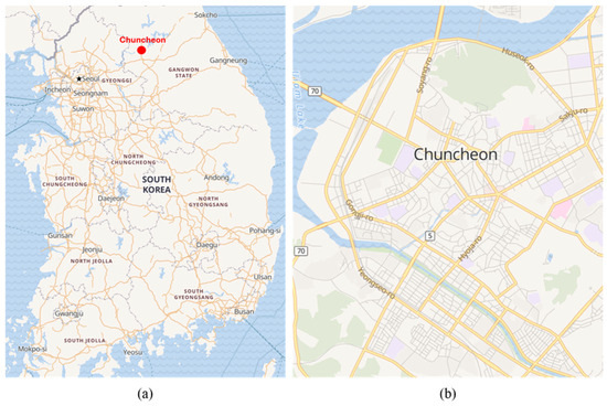
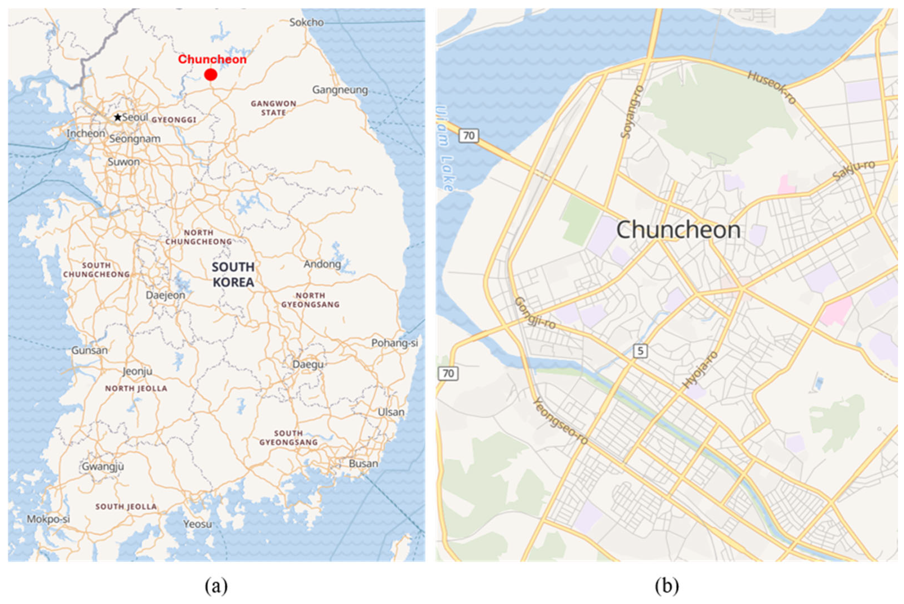
This study is conducted in Chuncheon, a medium-sized regional city in South Korea characterized by heterogeneous land-use patterns, including university districts, dense residential living areas dominated by high-density housing, commercial corridors, and peri-urban zones. As in many Korean cities, illegal waste dumping in Chuncheon is most frequently reported in residential environments rather than in formally industrial areas, making it a suitable case for examining spatially uneven dumping patterns within everyday urban living contexts.
Chuncheon exhibits clear contrasts between high-density residential areas and lower-density peripheral zones, as well as variation in service accessibility, population activity, and monitoring infrastructure. These characteristics allow for empirical examination of how illegal dumping complaints cluster spatially and how such clusters relate to surrounding urban context.
A map of the study area and the spatial distribution of administrative boundaries is shown in Figure 1.
Figure 1.
(a) Location of Chuncheon in Republic of Korea; (b) City of Chuncheon (source: Open Street Map).
3.2. The Data
The primary dataset used in this study consists of administrative complaint records related to illegal waste dumping, provided by the city council. The complaint dataset covers the period from January 2023 to May 2025 and initially comprises 2543 records. These records are treated as spatial and temporal signals indicating reported illegal dumping activity rather than as a complete census of all dumping events.
These records represent officially received complaints submitted through municipal channels and constitute the most direct form of administrative evidence regarding illegal dumping occurrences. Each complaint record contains information on the date of reporting, the reported location, a textual description of the complaint, administrative metadata, the reporting channel, the assigned enforcement unit, and the handling outcome (Table 1). Among these attributes, the spatial and temporal information, namely where and when dumping related complaints are reported, forms the core empirical basis of this study.
Table 1.
Illegal dumping complaint records.
Complaint records indicate where illegal dumping is reported, but they do not explain the urban conditions surrounding those locations. To describe the spatial context associated with reported dumping activity, this study integrated additional urban datasets. A set of municipal administrative datasets was collected, including school locations, CCTV coverage, population activity indicators, public facilities, parks, and tree lined street features. In addition, two open datasets were obtained from the national open data portal, namely the locations of studio type multi-family housing and designated household waste set out points. Together, these datasets capture key aspects of residential concentration, human activity levels, monitoring presence, environmental context, and access to legal waste disposal services. An overview of all datasets, including their sources and key attributes, is provided in Table 2.
Table 2.
Urban datasets integrated for spatial analysis of illegal dumping complaints.
A methodological caveat applies to the complaint data and is acknowledged here explicitly. Complaint density reflects both the underlying intensity of illegal dumping and the propensity of residents to report it, and reporting propensity is itself shaped by population density, civic engagement, and awareness of reporting channels. Reported complaints are therefore a proxy for dumping risk rather than a direct census of dumping events, and areas with more active residents may appear as hotspots partly because of higher reporting rather than higher dumping alone. The study addresses this concern in three ways. First, the framework is positioned as a tool for prioritizing patrol and monitoring effort, a task for which reported burden is itself operationally relevant, rather than as an estimator of absolute dumping volume. Second, the contextual variables are deliberately broad and are not limited to population activity, so that clusters are characterized by their joint residential, infrastructural, and activity profiles rather than by complaint counts alone. Third, the interpretation of clusters distinguishes between areas where high complaints coincide with dense residential and mixed-use conditions and areas where complaints are low despite the presence of large non-residential facilities, which helps separate genuine spatial concentration from artefacts of reporting behavior. The remaining gap between reported complaints and true dumping risk is noted as a limitation and is revisited in Section 5.
4. Analysis
4.1. Feature Construction and Screening
Spatial features were constructed to represent the urban context surrounding each illegal dumping complaint location. Using the geocoded complaint points as spatial references, surrounding urban elements were summarized within multiple distance ranges. For each contextual dataset, distance-based features were computed either as counts of nearby facilities or as binary indicators representing the presence of specific urban elements. This approach ensured interpretability and consistency across heterogeneous data sources.
To screen candidate features and assess appropriate spatial influence ranges, an unsupervised spatial clustering approach was applied. Specifically, we used DBSCAN (Density-Based Spatial Clustering of Applications with Noise) to group nearby complaint locations based on spatial density. Let denote the set of geocoded complaint locations and a distance metric. For a point , its neighborhood is , and is defined as a core point if . A point is directly density reachable from a core point if , and two points are density connected if there exists from which both points are density reachable. Under these definitions, a DBSCAN cluster is a maximal set of density connected points, while points that are neither core nor density reachable from any core point are treated as noise. Because DBSCAN identifies clusters without requiring prior specification of the number of clusters and distinguishes dense concentrations of observations from isolated noise points, it is well suited for exploratory analysis of spatial point patterns.
In this study, DBSCAN was used as an analytical support tool rather than as a predictive model. By aggregating nearby complaint locations into spatial clusters within a 500 m neighborhood radius, local spatial noise was reduced and complaint frequency could be evaluated at the cluster level. The clustering process grouped 1137 geocoded complaint locations into 174 spatial clusters.
For each cluster, complaint frequency and cluster level summaries of each candidate feature were calculated, and correlations were then computed between these feature summaries and complaint frequency across buffer distances from 100 m to 1000 m in 50 m increments. For each feature type, the distance threshold yielding the maximum correlation coefficient was selected as the representative influence range. The resulting maximum correlation coefficients and their corresponding distance thresholds are reported in Table 3, and the final analytical variables used in subsequent analyses are summarized in Table 4.
Table 3.
Correlations between spatial features and complaint frequency.
Table 4.
Final variables included in the analytical dataset.
4.2. Clustering of Complaint Occurrence Areas
Based on the validated feature variables identified in the previous section, K-means clustering was conducted to derive spatial patterns and typologies of complaint occurrence areas. K-means is a representative partition-based clustering algorithm that groups observations with similar attributes by minimizing within cluster variance based on Euclidean distance. Through this approach, the study aimed to identify distinct spatial distributions of complaint occurrence across Chuncheon City.
First, geocoded complaint locations were converted into spatial data, and a grid-based spatial aggregation was applied using a grid size of 1500 m. The grid resolution was determined by referring to complaint records and considering the typical daily patrol coverage of field enforcement officers as well as an approximate 30 min walking range. Complaint locations were then aggregated at the grid level, and both complaint counts and the selected feature variables were summarized for each grid cell.
Because the results of any grid-based analysis can depend on the chosen spatial unit, a concern formalized as the modifiable areal unit problem (MAUP), the 1500 m cell was selected on an explicit operational rationale rather than treated as neutral. The grid size was anchored to the area that a single field officer can realistically patrol within one working session, so that each cell corresponds to a deployable unit of enforcement effort and the resulting priority map can be acted upon directly. Finer resolutions tend to fragment contiguous hotspots into multiple low count cells, which reduces routing usefulness, whereas coarser resolutions blur the contrast between residential cores and adjacent nonresidential land. The 1500 m resolution therefore reflects a deliberate balance between spatial precision and patrol relevance. At the same time, we acknowledge that the absolute boundaries and counts of individual grid cells are not scale-invariant, and that MAUP is an inherent limitation of grid-based aggregation rather than a feature unique to this study. The contribution of the framework lies in the relative ordering of enforcement priority across functionally distinct urban areas, which is driven by the underlying spatial and functional characteristics of each zone rather than by the aggregation scale alone. A systematic multi scale sensitivity analysis, in which the clustering procedure is repeated across a range of grid resolutions and the stability of the priority ordering is quantified, is identified as an important direction for future work.
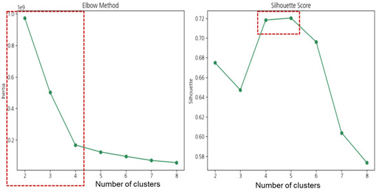
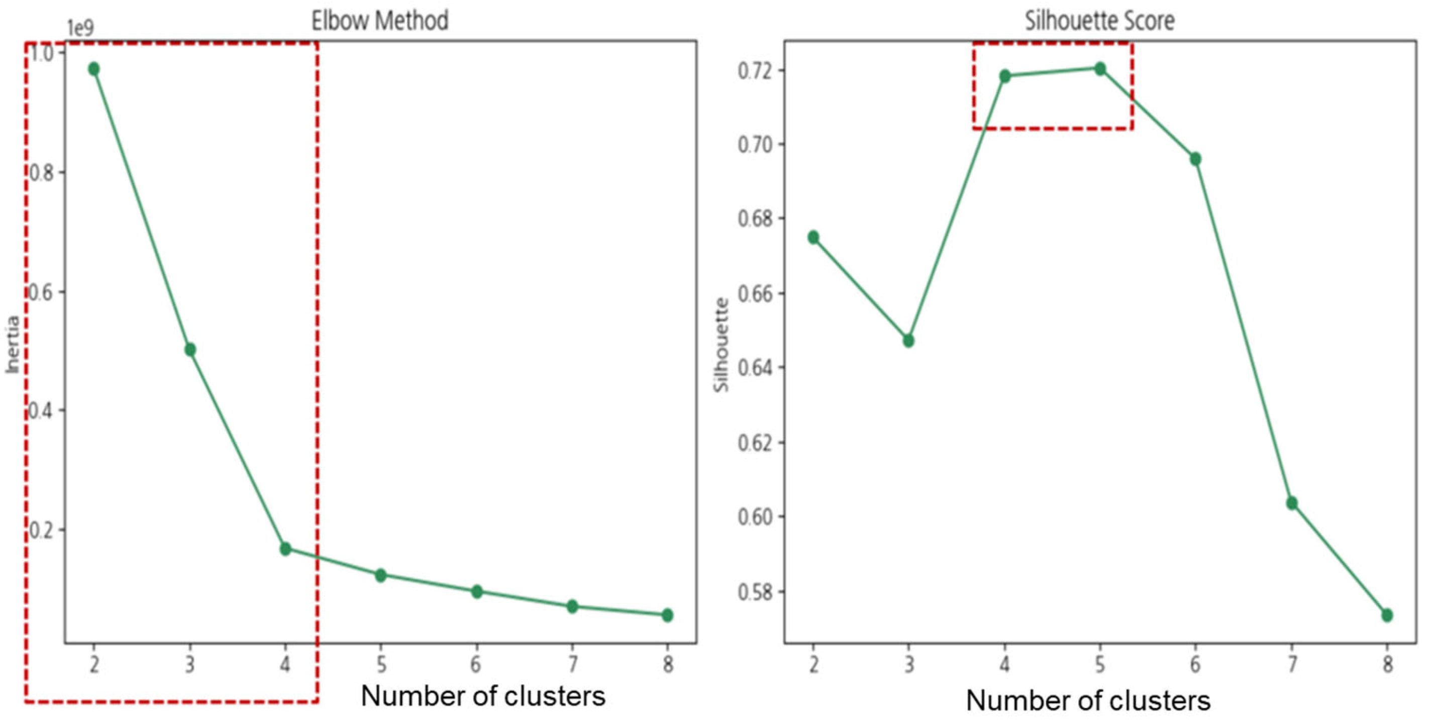
K-means clustering was subsequently applied to the grid level dataset to group areas with similar complaint intensity and environmental characteristics. The number of clusters was determined using a combination of the elbow method and silhouette scores. As shown in Figure 2, the elbow method indicated a clear inflection point at , where the decrease in within cluster inertia began to level off. At the same time, the silhouette score reached its maximum value of 0.72 at , indicating high cluster cohesion and separation. Based on these criteria, the optimal number of clusters was set to four.
Figure 2.
Clustering results.
Table 5 presents the results of the K-means clustering analysis, in which complaint occurrence areas were classified into four clusters based on the average number of complaints. For each cluster, numerical variables are reported as mean values, while binary variables are summarized as the total number of grid cells where the condition is satisfied.
Table 5.
Results of clustering analysis.
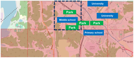
Among the four clusters, Cluster 1 exhibits the highest average complaint frequency and is therefore classified as the highest priority area for illegal waste dumping enforcement. An examination of its spatial characteristics, as illustrated in Figure 3, indicates that this cluster is predominantly located in areas adjacent to university districts and is characterized by the highest density of one room housing. In addition, the levels of living population across all age groups are substantially higher than those observed in other clusters.
Figure 3.
Cluster 1 area.
Cluster 1 also shows a high concentration of urban infrastructure, including CCTV installations, designated waste disposal sites, and parks. The coexistence of dense residential patterns, elevated population activity, and diverse urban facilities suggests that high intensity daily activity in these areas contributes to an increased frequency of illegal dumping complaints. These findings indicate that dense urban living environments with mixed land use characteristics are particularly susceptible to recurring waste related complaints and should therefore be prioritized in patrol and enforcement strategies.
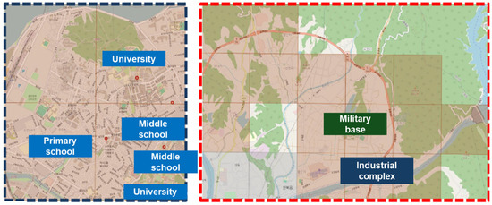
Cluster 2 exhibits heterogeneous spatial characteristics within the same cluster. As shown in Figure 4, the left subarea is characterized by a high concentration of educational facilities and a dense distribution of small-sized housing, forming a residential environment predominantly occupied by students and young adults. In contrast, the right subarea represents a medium-density area adjacent to military facilities and a complex of industrial lands. As a result, this area shows lower residential density, limited availability of urban infrastructure. Accordingly, Cluster 2 can be interpreted as a composite cluster in which complaint-intensive areas coexist with low-density zones, reflecting mixed spatial and functional characteristics.
Figure 4.
Cluster 2 areas.
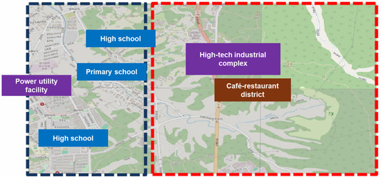
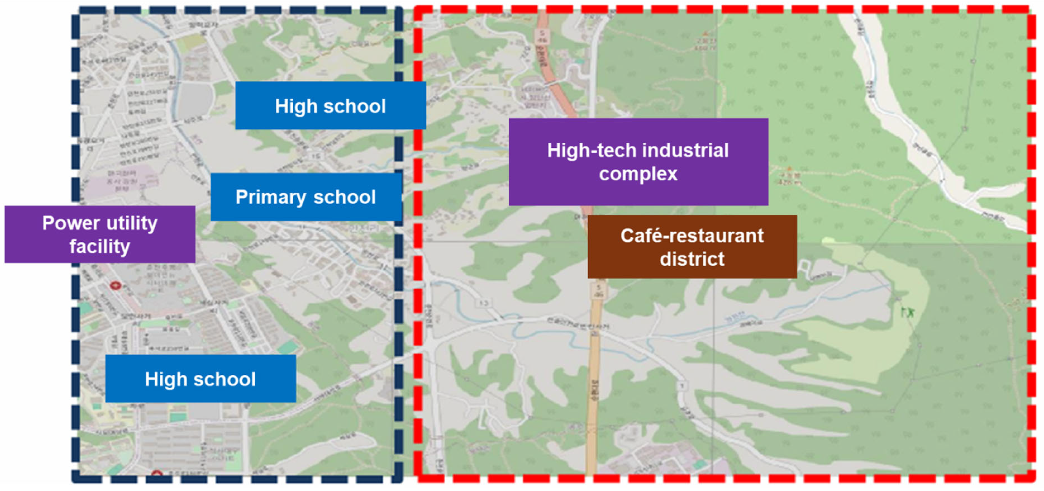
Cluster 3 also exhibits spatial heterogeneity across different areas. As illustrated in Figure 5, the left subarea shows a generally low density of small-sized one-room housing and contains a relatively large number of educational facilities. In contrast, the right subarea corresponds to a peripheral urban area where tourism and high-tech industrial facilities are concentrated. Owing to its low residential density and limited level of daily living infrastructure, this area exhibits a relatively low frequency of complaints.
Figure 5.
Cluster 3 areas.
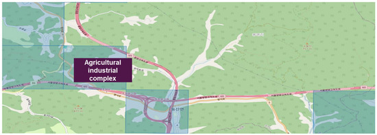
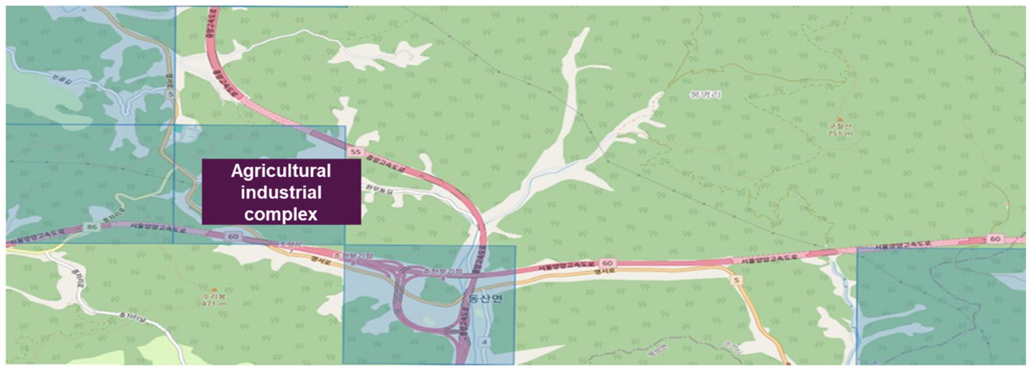
Cluster 4 was identified as having the lowest complaint frequency among all clusters. As shown in Figure 6, this cluster primarily consists of rural and predominantly nonresidential areas, including zones associated with an agricultural industrial complex, and it is characterized by the lowest population density. Consistent with this context, the availability of everyday urban amenities and facilities, such as parks, educational institutions, and clusters of cafés or restaurants, is limited. Accordingly, Cluster 4 is classified as a low-complaint-occurrence area and is assigned a lower priority in patrol and enforcement planning.
Figure 6.
Cluster 4 area.
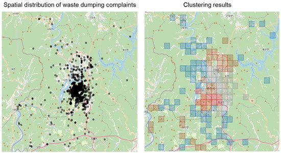
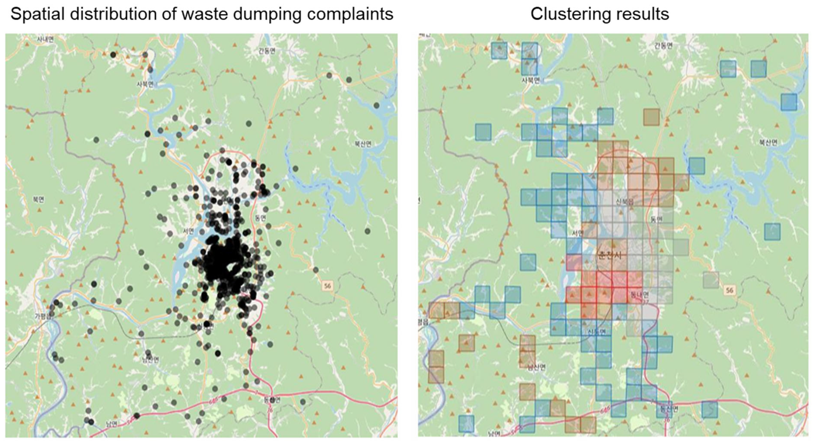
Finally, as illustrated in Figure 7, this study applied the K-means algorithm to 1137 identified complaint locations and conducted spatial grouping into 129 grid-based areas at a 1500 m resolution. Based on the resulting clusters, a four-level enforcement priority scheme was established by jointly considering complaint frequency and the density of key environmental and spatial features. This prioritization framework enables the efficient identification of patrol and enforcement target areas.
Figure 7.
Spatial distribution of complaints and clustering results.
4.3. Discussions
The results reveal that complaint occurrence is not uniformly distributed across the city but is strongly associated with specific urban spatial and functional characteristics. First, areas with high complaint frequency are consistently characterized by high residential density combined with intensive daily activity, rather than by a single facility type. Cluster 1, which exhibits the highest number of complaints, is dominated by dense one-room housing, proximity to university districts, and large volumes of living population across all age groups. These environments typically experience frequent population turnover, high pedestrian activity, and irregular waste generation patterns, all of which increase the likelihood of improper disposal and subsequent complaints. The coexistence of residential units, commercial activities, and public facilities further intensifies these pressures, suggesting that mixed-use urban environments are particularly vulnerable to recurring illegal dumping issues. This residential concentration is consistent with recent street-scale evidence from Brussels, where citizen-reported dumping clustered in residential streets shaped by levels of informal social control and neighborhood disorder rather than by any single facility type [14]. It contrasts, however, with spatial regression findings from Semarang, Indonesia, where population density was negatively associated with dumping [16]; this divergence likely reflects the Korean context, in which complaints predominantly concern improper household waste set-out under a volume-based fee system rather than clandestine dumping in secluded locations.
Second, the analysis indicates that the presence of waste disposal facilities alone does not necessarily reduce complaint frequency. In high-complaint clusters, designated waste disposal sites are often more numerous, yet complaints remain elevated. The availability of collection facilities was not a significant predictor of dumping elsewhere [16]. This finding suggests that illegal dumping is not solely driven by a lack of disposal infrastructure but is also influenced by behavioral factors such as convenience seeking, improper disposal timing, and limited compliance in high-activity areas. In other words, infrastructure provision without corresponding management and enforcement may be insufficient in dense urban contexts.
Third, several variables commonly assumed to deter illegal dumping, such as CCTV density, show relatively weak associations with complaint frequency at the cluster level. While CCTV installations are present in high-complaint areas, their density does not appear to systematically correspond to lower complaint levels. This may reflect limitations in surveillance coverage, insufficient deterrence effects, or displacement of dumping behavior to nearby blind spots. Similarly, the presence of parks or tree-lined streets does not exhibit a clear monotonic relationship with complaint occurrence, indicating that these environmental amenities alone do not directly influence dumping behavior.
The contrasting characteristics observed in Clusters 2 and 3 further highlight the importance of functional context. These clusters include areas where complaint-intensive zones coexist with medium- or low-density subareas, such as zones adjacent to military facilities, industrial complexes, or tourism-oriented developments. In such areas, lower residential density and reduced everyday living activity correspond to fewer complaints, even when large-scale facilities are present. This suggests that illegal dumping complaints are more closely tied to routine residential behavior and daily waste generation than to the mere presence of non-residential land uses.
Finally, Cluster 4 illustrates that rural and predominantly non-residential areas with low population density and limited everyday amenities are consistently associated with minimal complaint occurrence. In these contexts, waste generation is relatively predictable and regulated, and opportunities for opportunistic dumping are limited. As a result, these areas can be assigned lower enforcement priority without significantly increasing the risk of unmanaged dumping.
5. Conclusions
This study proposed a data-driven approach to identifying priority enforcement areas for illegal waste dumping by integrating spatial complaint records with urban environmental and population characteristics. The results demonstrate that illegal waste dumping complaints are not randomly distributed but are strongly associated with specific urban conditions. High-complaint areas are characterized by dense one-room housing, proximity to university districts, and high levels of daily population activity, often within mixed-use urban environments. In contrast, rural or predominantly non-residential areas with low population density and limited everyday amenities consistently exhibit low complaint frequencies. Importantly, the findings suggest that infrastructure-related variables such as waste disposal facilities or CCTV density alone do not sufficiently explain complaint occurrence, highlighting the role of behavioral and activity-based factors in illegal dumping patterns [17,18].
Based on these insights, the study developed a four-level enforcement priority framework that supports differentiated patrol and enforcement strategies. Rather than applying uniform enforcement efforts across all areas, the proposed framework enables municipalities to allocate limited resources more efficiently by focusing on high-activity residential environments that are more susceptible to recurring complaints. This clustering-based prioritization approach provides a practical decision-support tool for urban waste management and enforcement planning.
To illustrate how the framework translates into day-to-day operations, consider a municipal enforcement officer planning a patrol schedule for a given week. Each grid cell carries a priority label derived from its cluster assignment, so the officer begins by allocating the largest share of patrol time to first-tier cells, such as the dense one-room housing blocks adjacent to the university district, scheduling repeat visits during the high-activity periods when improper disposal is most likely. Second- and third-tier cells, which combine complaint-intensive cores with quieter subareas, receive periodic rather than daily attention, for example, a single scheduled inspection per week concentrated on the residential portion of the cell. Fourth-tier cells in rural and predominantly non-residential zones are placed on a low-frequency or complaint-triggered footing, freeing capacity for the higher tiers. In practice, the priority labels can be rendered as a simple color-coded map layer in the existing municipal geographic information system, allowing supervisors to convert the clustering output directly into patrol routes, inspection time budgets, and placement decisions for mobile monitoring resources. In this way, the algorithmic output functions as a routing and scheduling aid rather than as an abstract classification.
Implications and Limitations
Despite these contributions, several limitations should be acknowledged. First, the analysis relies on reported complaint data, which may not fully capture the true extent of illegal dumping activity. Complaint records are influenced by reporting behavior, awareness, and accessibility of reporting channels, potentially leading to underreporting or spatial bias. Second, the study employs static spatial variables and does not explicitly account for temporal variations, such as time-of-day, day-of-week, or seasonal effects, which may significantly influence dumping behavior. Third, while the clustering analysis provides an interpretable and operationally useful classification, it assumes relatively homogeneous cluster structures and may not fully capture complex non-linear spatial relationships. Finally, the analysis focuses on a single city, which may limit the generalizability of the findings to other urban contexts with different spatial structures or waste management systems.
Future research can address these limitations in several ways. Incorporating temporal dimensions into the analysis would enable the identification of time-specific dumping patterns and support dynamic patrol scheduling. The integration of additional behavioral indicators, such as land-use activity intensity or mobility data, could further improve the explanatory power of the model. Methodologically, future studies may explore advanced unsupervised or hybrid clustering approaches to better capture heterogeneous spatial structures. Finally, applying the proposed framework to multiple cities would allow comparative analysis and support the development of more generalizable, scalable strategies for managing illegal waste dumping.
Overall, this study demonstrates the value of combining spatial clustering with urban data integration to support evidence-based enforcement planning and highlights the potential of data-driven approaches in improving the efficiency and effectiveness of municipal waste management policies.
Author Contributions
Conceptualization, J.w.R.; Methodology, J.w.R.; Validation, H.S.; Formal analysis, J.w.R. and H.S.; Investigation, D.C.; Data curation, D.C.; Writing—original draft, J.w.R., H.S., D.C. and J.L.; Writing—review and editing, J.w.R. and J.L.; Supervision, J.L. All authors have read and agreed to the published version of the manuscript.
Funding
This research was supported in part by the Yonsei University Research Fund (Post Doc. Researcher Supporting Program) of 2025 (project no.: 2025-12--02025).
Data Availability Statement
The data presented in this study are not publicly available due to confidentiality agreements and privacy restrictions.
Conflicts of Interest
Authors Joung woo Ryu, Hyunji Sim, Daesung Cho were employed by the company ONYCOM. The remaining author declares that the research was conducted in the absence of any commercial or financial relationships that could be construed as a potential conflict of interest.
References
- Mngeni, A. Effects of illegal waste disposal on selected soil chemical properties and elemental concentrations in Mthatha, South Africa. Environ. Forensics 2025, 26, 250–262. [Google Scholar] [CrossRef] [Scilit]
- Vaverková, M.D.; Maxianova, A.; Winkler, J.; Adamcová, D.; Podlasek, A. Environmental consequences and the role of illegal waste dumps and their impact on land degradation. Land Use Policy 2019, 89, 104234. [Google Scholar] [CrossRef] [Scilit]
- Chen, J.; Zhang, L.; Song, L.; Ye, M.; Wang, L.; Fan, B.; Li, B.; Yang, Z.; Jin, R.; Jia, P. Effects of illegal solid waste dumping on the structure of soil bacterial communities: A case study in China. Toxics 2025, 13, 20. [Google Scholar] [CrossRef] [Scilit] [PubMed]
- Fazzo, L.; Manno, V.; Iavarone, I.; Minelli, G.; De Santis, M.; Beccaloni, E.; Scaini, F.; Miotto, E.; Airoma, D.; Comba, P. The health impact of hazardous waste landfills and illegal dumps contaminated sites: An epidemiological study at ecological level in Italian Region. Front. Public Health 2023, 11, 996960. [Google Scholar] [CrossRef] [Scilit] [PubMed]
- Triassi, M.; Alfano, R.; Illario, M.; Nardone, A.; Caporale, O.; Montuori, P. Environmental pollution from illegal waste disposal and health effects: A review. Int. J. Environ. Res. Public Health 2015, 12, 1216–1236. [Google Scholar] [CrossRef] [Scilit] [PubMed]
- Chong, A.C.Y.; Chu, A.M.Y.; So, M.K.P.; Chung, R.S.W. Asking sensitive questions using the randomized response approach in public health research: An empirical study on the factors of illegal waste disposal. Int. J. Environ. Res. Public Health 2019, 16, 970. [Google Scholar] [CrossRef] [Scilit] [PubMed]
- Warner, S.L. Randomized response: A survey technique for eliminating evasive answer bias. J. Am. Stat. Assoc. 1965, 60, 63–69. [Google Scholar] [CrossRef]
- Ajzen, I. The theory of planned behavior. Organ. Behav. Hum. Decis. Process. 1991, 50, 179–211. [Google Scholar] [CrossRef] [Scilit]
- Becker, G.S. Crime and punishment: An economic approach. J. Political Econ. 1968, 76, 169–217. [Google Scholar] [CrossRef] [Scilit] [PubMed]
- Wu, H.; Weng, X.; Li, Y.; Liu, S.; Ma, J.; Chen, R.; Yu, B.; Bao, Z. Critical construction waste minimization strategies for a circular economy in developing countries: A contractor’s perspective in China. Int. J. Environ. Sci. Technol. 2024, 22, 11211–11228. [Google Scholar] [CrossRef] [Scilit]
- Bao, Z.; Lu, W.; Chi, B.; Yuan, H.; Hao, J. Procurement innovation for a circular economy of construction and demolition waste: Lessons learnt from Suzhou, China. Waste Manag. 2019, 99, 12–21. [Google Scholar] [CrossRef] [Scilit] [PubMed]
- Yuan, H.P.; Du, W.B.; Ma, X.Z.; Liu, J.; Li, L.Y. Critical factors to influence the illegal dumping behavior of construction and demolition waste: An ISM-DEMATEL analysis. Dev. Built Environ. 2023, 14, 100159. [Google Scholar] [CrossRef] [Scilit]
- Fullerton, D.; Kinnaman, T.C. Household responses to pricing garbage by the bag. Am. Econ. Rev. 1996, 86, 971–984. [Google Scholar]
- Guyot, M.; Thomas, I.; Vanwambeke, S.O. From Complaints to Insights: A Geographical Analysis of Illegal Dumping by Citizen Sensor Data. 2024. Available online: https://ssrn.com/abstract=4793143 (accessed on 5 July 2026).
- Gibbs, J.P. Crime, Punishment, and Deterrence; Elsevier: Amsterdam, The Netherlands, 1975. [Google Scholar]
- Syafrudin, S.; Ramadan, B.S.; Budihardjo, M.A.; Munawir, M.; Khair, H.; Rosmalina, R.T.; Ardiansyah, S.Y. Analysis of Factors Influencing Illegal Waste Dumping Generation Using GIS Spatial Regression Methods. Sustainability 2023, 15, 1926. [Google Scholar] [CrossRef] [Scilit]
- Dubey, S.; Bailey, A.; Lee, J. Women’s perceived safety in public places and public transport: A narrative review of contributing factors and measurement methods. Cities 2025, 156, 105534. [Google Scholar] [CrossRef] [Scilit]
- Yoo, S.; Sheshadri, S.K.; Shukla, A.K.; Kim, N.S.; Lee, J. Insights into women’s perceived safety: Empirical findings from intercept surveys. Habitat Int. 2025, 166, 103626. [Google Scholar] [CrossRef] [Scilit]

Disclaimer/Publisher’s Note: The statements, opinions and data contained in all publications are solely those of the individual author(s) and contributor(s) and not of MDPI and/or the editor(s). MDPI and/or the editor(s) disclaim responsibility for any injury to people or property resulting from any ideas, methods, instructions or products referred to in the content. |
© 2026 by the authors. Licensee MDPI, Basel, Switzerland. This article is an open access article distributed under the terms and conditions of the Creative Commons Attribution (CC BY) license.