


Abstract
The stabilization of public infrastructure on active volcanic slopes presents significant geotechnical challenges, particularly in coastal regions exposed to extreme hydrological stressors. This paper presents a forensic diagnosis and the structural rehabilitation of the Porto da Cruz Cemetery (Madeira Island, Portugal), which suffered severe progressive failure following localized, shallow-founded interventions in 2004. Historical inclinometer data (2015–2022) revealed continuous deep-seated creep within the volcanic colluvium (Geotechnical Zone 2–ZG2) at rates up to 0.17 mm/day, triggered by basal fluvial undercutting. To mitigate these kinematic drivers, a systemic “Toe-to-Crest” stabilization paradigm was implemented. Following the hydraulic confinement of the slope’s lower boundary, a high-capacity deep foundation network—comprising 26 m rock-socketed micropiles and 600 kN active multi-strand anchors—was executed to bypass the failure plane and encastre directly into the competent basaltic bedrock (Geotechnical Zone 1–ZG1). The structural performance was validated through rigorous load testing and a real-time robotic Structural Health Monitoring (SHM) system. Post-construction telemetry confirmed absolute kinematic stabilization, maintained continuously throughout the critical execution phases and subsequent monitoring period (2024–2025). By integrating deep bedrock anchoring, pore-pressure mitigation, and digital telemetry, this case study validates the economic and geomechanical superiority of systemic subsurface bypass over reactive surface maintenance. Ultimately, it establishes a scalable, climate-adaptive engineering blueprint for safeguarding critical coastal heritage across Macaronesia against escalating environmental multi-hazards.
1. Introduction
1.1. Coastal Infrastructure and Climate Vulnerability
The structural resilience of buildings in volcanic archipelagos is increasingly threatened by coastal environmental stressors interacting with unstable geological formations. In island territories like Madeira, steep topographies and deep-seated colluvium deposits create a high-risk landscape for critical public infrastructure [1]. Recent research emphasizes that insular urban growth faces severe maintenance challenges due to the combined effects of aggressive maritime aerosol exposure and localized geotechnical instability [2]. To address these challenges, implementing data-driven frameworks for Structural Health Monitoring (SHM) has become an essential paradigm to validate engineering performance under escalating climate stressors [3].
Managing critical civil infrastructure in hazard-prone areas requires a structural transition from traditional reactive maintenance to proactive, climate-adaptive engineering policies [4]. The Porto da Cruz case study exemplifies a complex, compound hazard scenario where persistent riverbank erosion and progressive slope creep destabilized critical public assets [5]. The coastal landscape of Northern Madeira is highly exposed to Atlantic swells and intense, short-duration pluvial events. In Porto da Cruz, the sharp spatial interdependence between the municipal cemetery, the regional road (ER110), and the Junçal Stream creates a high-risk geotechnical boundary scenario. As illustrated in the site overview (Figure 1), the stream’s hydraulic action directly undercuts the base of the slope. This structural undermining actively removes lateral confinement, triggering a retrogressive slope failure mechanism that threatens the stability of the entire infrastructure complex.
Figure 1.
Panoramic view of the Porto da Cruz slope, illustrating the spatial interdependence between the cemetery (crest), the Regional Road ER110 (toe), and the Junçal Stream. The image highlights the high exposure to hydraulic erosion and the steep geomorphology typical of Madeira’s northern coast (Source: Photographic survey adapted from CMM technical reports).
1.2. Problem Statement and Generalizable Geomechanical Laws
The destabilization of the Porto da Cruz Cemetery results from multi-hazard interactions, were distinct environmental stressors trigger cascading failure mechanisms. In volcanic island environments, the primary driver of geotechnical instability is the synergistic effect of intense rainfall and the subsequent increase in pore pressure within unstable colluvium layers (ZG2) [1,6]. These deposits possess low shear strength and exhibit a continuous creep phenomenon. This progressive movement is further exacerbated by the hydrological action of the adjacent Junçal Stream [7]. Located at the slope’s base, the Junçal Stream induces aggressive lateral erosion that removes the toe support of the embankment. This basal undercutting is critical because the regional road (ER110) acts as a structural buffer between the watercourse and the cemetery. Consequently, riverbank degradation directly translates into a loss of lateral confinement for the slope, a mechanism structurally detailed in the conceptual failure and stratigraphic model [8] (Figure 2). Forensic evidence from a longitudinal photographic survey (2019–2022) confirms that the structural distress was systemic rather than localized, manifesting as deep-seated rotational movements that entirely bypassed the legacy shallow foundations [9].
Figure 2.
Geotechnical stability model and slope failure back-analysis. The cross-section illustrates the comprehensive stratigraphic sequence and the deep-seated circular slip surface (red dashed line) identified in the Porto da Cruz slope. The upper geotechnical unit comprises Geotechnical Zone 3 (ZG3—Anthropogenic Fill/Slope deposits) and Geotechnical Zone 2 (ZG2—Volcanic Colluvium, Weathered Tuffs, and Tuffs with volcanic bombs), representing the unstable creeping mass. The deeper unit constitutes Geotechnical Zone 1 (ZG1—Compact Vacuolar Basalts and Fractured Basalts), providing the competent crystalline bedrock horizon required for deep structural rock-socketing. The model highlights the critical instability at the toe caused by the Junçal Stream undercutting, which directly threatens the regional road (ER110) and the upper cemetery platforms (Source: Adapted from CENOR and ANCORPOR).
Therefore, the problem is defined as a coupled geotechnical and hydraulic failure. Traditional reactive maintenance, focused on cosmetic repairs of wall cracks and pavement settlement, proved ineffective as it failed to address the deep-seated nature of the slide [3,10]. Beyond this specific empirical observation, a significant knowledge gap exists regarding the long-term lifecycle performance of public infrastructure built on active volcanic colluvium, especially when subjected to progressive and coupled fluvial erosion over multi-decade scales [5,11]. Most studies in the existing literature focus on short-term monitoring or immediate post-disaster repairs, failing to clarify the generalizable mechanics of long-term soil–structure interactions.
To bridge this literature gap and elevate this case study into a scalable methodology, this research abstracts three generalizable engineering-geological laws from a 25-year comprehensive dataset:
- The Boundary Displacement Constraint Law: Demonstrating that the global Factor of Safety (FSg) and kinematic field of upper structural platforms are non-linearly governed by the mechanical and hydraulic confinement of the lower boundary (toe support).
- The Passive–Active Synergy Principle: Modeling how deep subsurface hydrological control systems actively preserve internal soil matrix friction, directly minimizing the parasitic lateral shear forces transmitted to deep deep-anchored structural systems.
- The Subsurface Crystalline Bypass Paradigm: Mathematically validating the long-term lifecycle safety and economic return of structural rock-socketing into baseline competent basaltic bedrock (ZG1), intentionally bypassing the unstable creeping layers.
The primary objective of this research is to evaluate the technical and economic viability of this integrated framework. Specifically, this study aims to:
- Analyze the geomechanical drivers that led to the failure of the 2004 shallow foundations.
- Quantify the impact of the 2013–2016 base stabilization (ER110 and Junçal Stream) on the upper slope’s equilibrium.
- Validate the structural response of the deep-anchoring system using real-time robotic Structural Health Monitoring (SHM) telemetry during the immediate construction and post-construction framework (2024–2025).
- Propose a quantified, scalable decision matrix for climate-adaptive infrastructure management in island territories.
By synthesizing 25 years of forensic data, summarized in the historical timeline (Table 1), monitoring reports, and execution projects, this paper provides a robust evidence base for transitioning from reactive ‘patchwork’ maintenance to high-resilience engineering in volcanic archipelagos.
Table 1.
Chronology of slope instability and engineering responses at Porto da Cruz (2000–2025).
1.3. Research Significance
The significance of this research lies in its transition from a reactive, superficial maintenance paradigm to a proactive, integrated resilience strategy. Historically, the management of the Porto da Cruz Cemetery infrastructure relied on localized repairs of masonry walls and pavement settlements. This historical approach addressed visual symptoms but failed to mitigate the underlying, deep-seated geotechnical risks [10]. This study provides a scientific validation of an integrated slope stabilization hierarchy. It demonstrates that the structural performance of buildings on unstable volcanic formations is fundamentally dependent on securing the lower boundary conditions [7,8] (Figure 3).
Figure 3.
Detailed view of the Porto da Cruz slope infrastructure. The proximity of residential and religious structures to the unstable volcanic deposits necessitates a shift from localized repairs to systemic stabilization to ensure long-term resilience (Source: Photographic survey adapted from CMM technical reports).
Furthermore, this work contributes to the field of forensic engineering by analyzing a 25-year dataset to contrast the long-term failure of legacy shallow foundations against the stability provided by deep-anchored engineering systems, as summarized in Table 2. The multi-temporal integration, shifting from periodic manual readings to automated robotic Structural Health Monitoring (SHM), offers a scalable operational framework for critical infrastructure management across vulnerable island territories [3].
Table 2.
Comparison between traditional reactive maintenance and the proposed integrated resilience framework.
By documenting the successful bypass of active geomechanical shear zones through 26 m rock-socketed micropiles, this research establishes a structural benchmark for climate-adaptive public works in Macaronesian environments. It provides an empirical roadmap for territories where complex multi-hazard interactions require systemic, unified engineering configurations rather than isolated structural patches [1,11].
2. Forensic Diagnosis
2.1. Study Area
The Porto da Cruz Cemetery is situated on a steep coastal slope on the North Coast of Madeira Island. Its structural stability is intrinsically governed by its geographic position, being strategically bounded to the East by a critical infrastructure corridor and a natural hydrological border: the ER110 Regional Road and the Junçal Stream. The spatial relationship between these elements is illustrated in the site location map (Figure 4).
Figure 4.
Site location in Porto da Cruz, Madeira. The map highlights the spatial proximity between the cemetery platforms, the ER110 road, and the Junçal Stream. The red circle indicates the specific study area. (Source: Photographic survey adapted from CMM technical reports).
The site’s configuration creates a direct dependency between the cemetery’s upper platforms and the stability of its Eastern boundary. The ER110 road is positioned at a lower elevation, effectively acting as the structural “toe” of the cemetery’s embankment. Further East, the Junçal Stream flows parallel to the road, representing a persistent hydraulic threat. During extreme rainfall events, the stream’s erosive action on the left bank can undercut the foundation of the ER110, triggering a retrogressive failure mechanism that propagates upslope towards the cemetery [7,8].
This spatial arrangement—where both the road and the stream are located to the East—justifies the “Toe-to-Crest” rehabilitation hierarchy. The intervention recognized that the cemetery’s structural integrity was unfeasible without first securing the riverbank and the road’s platform against the lateral thrust of the volcanic colluvium (ZG2). This alignment emphasizes the multi-hazard nature of the site, where hydraulic erosion and geotechnical creep are coupled at the slope’s base, demanding an integrated stabilization of the entire Eastern frontage.
2.2. Geological and Geomechanical Model
The geological-geotechnical characterization of the Porto da Cruz coastal slope was established through a comprehensive subsurface investigation, including mechanical soundings (S1–S11) and Standard Penetration Tests (SPT). The interpretative geomechanical model identifies three primary geotechnical zones (ZG) that govern the site’s stability, as structurally detailed in the unified cross-sectional stability model (Figure 2):
- ZG3—Anthropogenic Fill and Slope Deposits: This uppermost and most vulnerable layer corresponds to the fill (At) and cover deposit (DC) horizons mapped in the cross-section. It consists of loose anthropogenic fill and unconsolidated slope debris exhibiting very low geomechanical resistance (NSPT < 5). This zone is highly susceptible to surface erosion and shallow landslide mechanisms.
- ZG2—Volcanic Colluvium Complex: This intermediate stratum encompasses the slope deposits (DV), weathered tuffs (TD), and tuffs with volcanic bombs (TβV). It consists of a heterogeneous mixture of basaltic boulders, cobbles, and gravels embedded in a silty-clay matrix. With thicknesses ranging from 5 to 15 m, ZG2 exhibits low shear strength and high sensitivity to pore-pressure variations. Historical monitoring through inclinometers (I2N, I3N, and I4N) confirmed that the active failure surface develops at the base of this unit, exhibiting continuous baseline creep rates.
- ZG1—Basaltic Bedrock Complex: This competent crystalline foundation level consists of the basaltic volcanic complex—comprising compact vacuolar basalts (βVC) and fractured basalts (βF)—of the Madeira Island basement. This zone provides high bearing capacity (NSPT > 50, reaching refusal). It serves as the non-deformable anchoring horizon for the 2024 deep foundation and resilient active reinforcement design.
To support the stability analysis, the geomechanical properties assigned to each layer in the numerical model are summarized in Table 3.
Table 3.
Geomechanical parameters of the identified geotechnical zones (adapted from [8,15]).
Interpretative cross-sections reveal that the ZG1 interface inclines significantly towards the East, with the depth of the stable bedrock increasing as the slope approaches the Junçal Stream [15]. According to the ANCORPOR findings, this boundary occurs at elevations varying from 67–77 m in the Western alignment to 52–59 m in the Eastern alignment [6].
This geometric model was decisive in the 2024 redesign. It established that the new 26 m micropile foundations had to bypass both the unstable ZG3 (fill) and ZG2 (colluvium) to be encastred specifically into the ZG1 (bedrock). The numerical back-analysis (Figure 2) confirms that any stabilization attempt limited to the upper 10 m would fail to intersect the critical slip plane, rendering surface-level interventions ineffective against the deep-seated landslide mechanism.
2.3. The “Toe-to-Crest” Strategy
The fundamental principle of the 2013–2024 intervention was the establishment of a “Toe-to-Crest” stabilization hierarchy. This strategy dictated that the lower boundary conditions of the slope—the “toe”—had to be structurally secured before any reconstruction of the upper cemetery platforms could be considered technically viable. In geotechnical terms, the ER110 regional road and the adjacent left bank of the Junçal Stream constitute the critical support base for the entire unstable mass.
Historical data confirmed that the increased hydraulic energy of the stream, which led to a 2 m riverbed deepening following the 2013 extreme rainfall events, was the primary trigger for the loss of basal confinement [7,8]. This scouring process destabilized the road platform and, consequently, removed the lateral support for the volcanic colluvium (ZG2) higher up the slope.
The rehabilitation sequence was divided into two distinct but interdependent phases:
- Phase I (Toe Consolidation and Fluvial Hydraulics): This phase focused on stabilizing the ER110 frontage by constructing a massive counterweight embankment in the stream valley. To protect this embankment from further erosion, a 296 m reinforced concrete U-shaped channel was built to divert the Junçal Stream, accompanied by a large-scale energy dissipation basin [8]. These structures were designed for a 100-year return period flood, ensuring the slope’s base is no longer susceptible to hydraulic undercutting.
- Phase II (Crest and Building Reconstruction): Only after the successful consolidation of the slope’s base and the stabilization of the ER110 platform—which had previously recorded a 40 cm horizontal displacement—was it technically feasible to implement the cemetery’s deep foundation system [5,8]. This phase involved the installation of 26 m micropiles and active 600 kN anchors. These elements were specifically designed to bypass the active failure plane and anchor directly into the stable basaltic bedrock (ZG1), as identified in the geomechanical model (Figure 2) [16,17,18].
This hierarchical approach effectively mitigated the risk of “cascading failure.” By investing approximately €10 M in the fluvial and road stabilization (Phase I) prior to the €2.4 M cemetery reconstruction (Phase II), the engineering strategy established a stable foundation for the entire hillside [8,19]. This integrated “bottom-up” methodology ensures that the structural performance of the new cemetery and chapel is protected by a multi-layered defensive system, providing a robust solution for high-risk volcanic environments [3,5].
The sequential execution of these phases, transitioning from the hydraulic protection of the stream to the deep sub-surface anchoring of the cemetery, is fully integrated within the unified stratigraphic and stability layout (Figure 2). By consolidating the boundary parameters directly into a single cross-sectional reference, the spatial interdependence of the multi-stage infrastructure evolution is made geomechanically distinct, eliminating graphical redundancy and validating the bottom-up stabilization hierarchy.
2.4. Evolution of Design Philosophies
The structural history of the Porto da Cruz Cemetery reveals a paradigm shift in engineering philosophy, moving from a surface-level aesthetic approach to a deep-seated geotechnical strategy. The original 2004 project was primarily focused on architectural expansion and landscaping, with an investment of approximately €20,000 aimed at “construction and gardening works” [10]. In this initial phase, the design relied on gravity-based masonry walls and shallow foundations (spread footings) resting directly on the upper layers of the volcanic colluvium (ZG2). This philosophy assumed a stable soil–structure interaction, failing to account for the deep-seated failure planes and the systemic instability of the Eastern frontage [6,8].
This disparity in engineering rigor and financial commitment is summarized in Table 4.
Table 4.
Comparison between the 2004 localized project and the 2024 integrated design.
The vulnerability of this localized approach was exposed following the extreme rainfall event of November 2013. Forensic data from the 2016 study revealed that the “cosmetic” repairs were insufficient to withstand a landslide mechanism that induced cumulative horizontal displacements of 40 cm and vertical settlements of 21 cm at the slope’s base [8]. The clinical manifestation of this systemic failure is documented in Figure 5, showcasing the severe structural distress within the cemetery tiers prior to the 2024 intervention.
Figure 5.
Forensic documentation of structural pathologies (2013–2022): (a) Severe diagonal tension and shear cracks in masonry structures; (b) Ground surface rupture and pavement settlement caused by active deep-seated creep; (c) Structural separation and outward tilting of legacy retaining walls (Source: Photographic survey adapted from CMM technical reports).
Mathematically, the failure of the 2004 design is explained by the inability to maintain a Global Factor of Safety (FSg) above unity during peak pore-pressure events:
While the 2004 project treated the cemetery as an isolated building, the 2024 design operates under an “Integrated Resilience” framework. This new philosophy acknowledges that the cemetery’s stability is contingent on the large-scale stabilization of the Junçal riverbank and the ER110 road, an integrated effort representing a global investment exceeding €12 M [5,8,19].
The 2024 design priorities shift from surface ornamentation to subsurface bypass. By replacing shallow footings with 26 m micropiles that penetrate the basaltic bedrock (ZG1), effectively bypassing the ZG2 unstable mass as modeled in Section 2.2, the engineering team addressed the root cause of the 8.5 mm/day creep rates identified in the pre-intervention monitoring [8,15]. This implementation is documented in Figure 6, which illustrates the technical complexity of drilling operations in restricted spaces adjacent to distressed structures.
Figure 6.
Execution of the 26 m micropile system. (a) Drilling operations in restricted spaces; (b) Handling of drilling equipment adjacent to existing structures. The design prioritized subsurface bypass over surface aesthetics to ensure structural stability (Source: Photographic survey adapted from CMM technical reports).
This evolution reflects a broader trend in Macaronesian engineering: the transition from “patchwork” reactive maintenance to data-driven, performance-based resilient design [3,11].
2.5. Quantitative Evidence
To justify the transition from localized repairs to a high-impact structural intervention, a multi-scalar diagnostic campaign correlated the longitudinal pathological survey (detailed in Section 2.4) with long-term quantitative monitoring. This integrated approach allowed the engineering team to verify the “ground truth” of the slope’s instability, linking surface damage to deep-seated geomechanical movements.
The geotechnical monitoring of the slope was conducted in two distinct phases by the Regional Laboratory of Civil Engineering (LREC). The initial campaign, carried out in 2015, established the baseline data required for the 2016 Junçal road stabilization project. Following the completion of the road works, monitoring was resumed in late 2019 to support the forensic diagnosis and geotechnical redesign of the cemetery rehabilitation, with continuous data collection extending until 2022 [9,11]. This temporal gap (2015–2019) and the subsequent longitudinal readings confirmed that the slope remained in a state of persistent, non-stabilized creep, notwithstanding the localized stabilization of the riverbank [8,13,20].
The severity of the landslide mechanism is evidenced by the progressive destruction of the monitoring infrastructure. Initially, a comprehensive network of 15 inclinometers was deployed to characterize the kinematics of the various cemetery platforms. However, the extreme magnitude of cumulative ground deformations led to the mechanical shearing or obstruction of the casings. By the final diagnostic phase in 2022, 10 out of the 15 sensors were rendered inoperable, leaving only 5 functional inclinometers (I2N, I3N, I4N, I6N, and I11N) to calibrate the 2024 resilient design [9,12].
To eliminate potential diagnostic bias stemming from the selective survival rate of the monitoring instrumentation, a systematic forensic reconstruction of the 10 failed inclinometers was conducted. Although progressive cumulative ground deformations induced mechanical shearing or severe casing ovalization—rendering these tubes impassable for standard LREC monitoring probes—the precise depths and timelines of these structural obstructions provided critical discrete kinematic data. Mapping the clipping depths of the 10 deformed instruments revealed a highly consistent failure horizon located at depths ranging from 12.5 m to 24.0 m in the central sector, and reaching up to 45.0 m near the eastern boundary front. To quantify the geomechanical uncertainty of this data transformation method and address potential local stress concentrations or construction disturbances, a spatial variance analysis (σ2) was executed. The discrete structural clipping depths were cross-correlated with the continuous shear profiles of the 5 surviving inclinometers (I2N, I4N). The statistical evaluation yielded a high spatial correlation coefficient (R2 = 0.89), defining a localized boundary uncertainty zone bounded within an absolute spatial margin of ±1.2 m. Within this verified error margin, these structural clipping horizons correlate directly with the primary lithological contact interface between the unstable volcanic colluvium Complex (ZG2) and the stable basaltic basement complex (ZG1). Consequently, when calibrated against this uncertainty threshold, the mechanical failure of the monitoring infrastructure systematically cross-verified the deep-seated geometry of the primary circular slip surface, transforming compromised hardware into high-probability spatial indicators for slope back-analysis validation.
The inclinometric displacement profiles (Figure 7) provide a clinical “X-ray” of the subsurface failure. Sensor I2N, positioned at the lower boundary near the Eastern frontage, detected critical activity at the 45 m depth mark, pinpointing the primary failure plane at the ZG2/ZG1 interface [15,18]. A detailed analysis of the I2N (Axis B) profile reveals a cumulative offset of 25 mm within the 13–24 m depth interval, identifying a secondary shear surface within the volcanic colluvium [8,12]. In the central sector, sensor I4N exhibited high-amplitude irregular displacement readings starting at a depth of 20 m, indicating a disorganized sliding mass that entirely bypassed the legacy 2004 shallow foundations [5,8].
Figure 7.
Cumulative inclinometric displacement profiles [9]. High-amplitude irregular displacement readings outside the vertical reference axis reveal active deep-seated shear zones characterized within the creeping volcanic mass (ZG2), while near-surface fluctuations fall strictly within the statutory instrument tracking tolerances.
Furthermore, sensor I6N recorded a steady displacement rate of 0.17 mm/day in May 2021 [9,13,20]. This combined quantitative record—the verified shear zones, the persistent creep rates, and the physical destruction of the monitoring network—provided the ultimate technical justification for the 2024 intervention. The data proved that only a high-capacity system, such as 26 m micropiles anchored into the stable ZG1 basaltic bedrock, could ensure long-term structural resilience against the deep-seated rotational mechanism [11,14].
3. Materials and Methods
The engineering framework developed for the stabilization of the Porto da Cruz infrastructure complex integrates multiple sub-surface geomechanical domains. While individual reinforcement components—such as deep rock-socketed micropiles, active ground anchoring, and sub-horizontal deep drainage networks—rely on established classical geotechnical techniques, their scientific innovation emerges from their systemic, coupled implementation operating under an advanced cyber–physical architecture. Instead of serving as isolated structural repairs that merely redistribute internal stress fields, these sub-surface elements function as a dynamic, responsive composite system. Real-time high-precision kinematic feedback loops from an automated robotic telemetry network are continuously cross-correlated and synchronized with piezometric pore-pressure fluctuations. This holistic optimization framework establishes a proactive lifecycle risk-management protocol, transitioning conventional slope stabilization layouts into an active, data-driven, and climate-adaptive resilience framework specifically configured to suppress retrogressive shear failures in fragile volcanic coastal slopes.
3.1. Deep Foundation and Anchoring Strategy
The structural stabilization of the Porto da Cruz Cemetery was achieved through an integrated framework combining deep foundations with active ground anchoring systems. Designed to explicitly bypass the critical failure envelope identified during the forensic diagnostic phase, this strategy ensured that the new superstructures (the Chapel and Ossuary blocks) were mechanically coupled to the stable basaltic bedrock (ZG1), thereby mitigating the kinematic risks associated with the active creep of the volcanic colluvium (ZG2).
3.1.1. Kinematic Interaction and the Micropile “Pinning” Mechanism
To guarantee structural integrity against differential settlements and deep-seated shear, a network of high-capacity micropiles was executed. Functioning as deep shear pins, these micropiles traverse the active failure plane, transferring the building’s vertical and horizontal stresses safely to the non-deformable bedrock and effectively isolating the overlying structures from the surface kinematics of the ZG2 layer [21].
The elements were reinforced with N80 high-yield steel tubular casings and injected with high-strength cementitious grout. This robust configuration was engineered to resist not only the axial loads from the superstructure but also the severe parasitic lateral thrusts (shear forces) imposed by the sliding colluvium mass. To achieve this, the micropiles were drilled to maximum depths of 26 m, ensuring a minimum structural rock-socketing (embedment) of 3 to 5 m directly into the competent ZG1 basaltic stratum [5,17].
To ensure effective load transformation and optimal geomechanical retention, the deep foundation network was organized according to strict geometric criteria. The micropiles were executed in a staggered grid layout with a nominal spacing varying between 1.50 m and 2.00 m (corresponding to approximately 6 Ø to 8 Ø, where Ø is the drilling diameter), optimized to maximize group efficiency, minimize the group effect reduction factors, and ensure an even structural load transfer directly into the competent bedrock (ZG1). This grid configuration allows the pile caps to act as a monolithic binding unit, enhancing the ‘pinning’ mechanism across the critical ZG2/ZG1 landslide interface.
3.1.2. Active Anchoring System and Lateral Stabilization
The lateral stabilization of the primary retaining structures, specifically wall MsR4, was ensured by a system of permanent active multi-strand ground anchors. Unlike passive soil nails, these active anchors introduce a critical pre-stress force directly into the slope. This active confinement increases the effective normal stress along potential failure surfaces, significantly elevating the global Factor of Safety (FoS) of the terraced platforms [22].
To ensure the transparency and replicability of the structural model, the primary design parameters for both the micropile and anchoring systems are synthesized in Table 5.
Table 5.
Technical specifications and design parameters for the deep foundation and active anchoring systems.
3.1.3. On-Site Validation and Testing Protocols
Given the aggressive, chloride-rich maritime environment of Porto da Cruz, the anchors featured rigorous Double Corrosion Protection (DCP) systems [2,19]. Furthermore, the reliability of the 600 kN nominal design load was empirically validated on-site. Each anchor was subjected to strict suitability and acceptance testing protocols (Table 6) prior to lock-off. These procedures were critical to confirm the geotechnical bond stress at the grout–ground interface and to verify the elastic response of the tendon’s free length, ensuring the system’s long-term resilience against extreme hydrological events [23].
Table 6.
Acceptance and suitability testing protocols for the 600 kN active ground anchors.
3.2. Hydrological Control and Subsurface Drainage Design
The management of surface watercourses, groundwater flow, and the mitigation of internal pore-pressure buildup were identified as critical engineering prerequisites for the long-term stabilization of the Porto da Cruz Cemetery infrastructure. According to Terzaghi’s classical principle of effective stress, the saturation of the uncompacted volcanic colluvium Complex (ZG2) drastically reduces the effective shear strength of the soil matrix, acting as the primary trigger for the episodic acceleration of historical creep rates [6,12]. To neutralize this kinematic driver, an integrated multi-scalar hydraulic and subsurface drainage network was implemented to ensure continuous runoff management and the rapid drawdown of the internal piezometric level during intense meteoric events.
To eliminate the primary driver of basal degradation, the geometry and structural wall thickness of the 296 m reinforced concrete U-channel were calculated using peak discharge simulations based on a 100-year return period flood event (T = 100 years). This design envelope ensures that the hydraulic alignment accommodates extreme pluvial torrents without overtopping or velocity-induced scouring. Additionally, the downstream energy dissipation basin neutralizes kinetic actions at the toe, preserving local bank confinement far beyond standard decadal storm thresholds.
Complementing this macro-hydraulic alignment at the base, the subsurface hydrological control within the upper slope architecture comprised two core engineered drainage solutions:
- Sub-Horizontal Deep Drains: A series of perforated PVC pipes, enveloped in geotextile filters, were installed at strategic inclinations to intercept perched water tables within the slope. Drilled directly into the ZG2 stratum, these drains capture internal seepage before it accumulates at the critical failure interface near the ZG1 bedrock [15,24];
- Vertical Geocomposite Drainage: To protect the new active retaining walls (MsR4) from hydrostatic thrust, synthetic geocomposites (geodrains) were installed behind the concrete faces. These elements facilitate the rapid vertical flow of water towards the basal collection system, preventing the localized pore-pressure peaks that previously induced the out-of-plane rotation of the legacy 2004 masonry structures [10,25].
This coupled hydrological control framework acts as a crucial passive stabilization mechanism that operates in direct synergy with the active confinement provided by the pre-stressed 600 kN ground anchors. By dynamically maintaining pore-pressure fields below critical geomechanical failure thresholds, the drainage intervention preserves the internal friction and effective stresses of the volcanic colluvium mass. Consequently, this system integration minimizes the parasitic lateral shear loads transmitted to the 26 m rock-socketed micropile foundations, safeguarding structural integrity during compound multi-hazard events [5,21].
3.3. Automated Structural Health Monitoring
The ultimate validation of the stabilization works and the lifecycle assessment of the structural performance are conducted through a state-of-the-art Structural Health Monitoring (SHM) framework. This setup represents a significant technological leap from the manual, periodic inclinometer readings performed during the diagnostic phase (2015–2022) to a fully automated, real-time robotic monitoring system implemented during the 2024–2025 rehabilitation [3,9,11].
The SHM architecture operates as a digital twin of the site’s kinematics, designed to provide continuous, high-precision data on the three-dimensional displacement field of the cemetery platforms. To ensure long-term reproducibility and operational transparency, the network architecture is specified across four core technical layers:
- Robotic Total Station (RTS) Node: An automated, high-precision Leica Nova TM60 robotic total station managed via SISGEO W-wecare (version 2.0) automated software was anchored to a geologically stable reference pillar outside the active landslide influence zone. The RTS executes autonomous measurement cycles at a pre-programmed sampling frequency of every 2 h (t = 2 h), targeting a dense network of optical prisms distributed across critical structural nodes (chapel columns, retaining walls, and platform crests) [11,14];
- Data Transmission Protocol and Cloud Telemetry: The macroscopic RTS surface data is integrated with deep geotechnical instrumentation, including newly installed inclinometers and piezometers targeting the ZG2/ZG1 interface. The recorded multi-scalar displacement vectors and data packets are wirelessly transmitted to a cloud-based platform for real-time visualization. This telemetry system utilizes cellular 4G/LTE edge gateways running industrial Modbus-RTU protocols, guaranteeing secure, reliable, and continuous data ingestion into the remote storage servers [5,22];
- Power Supply Configuration: To safeguard system operation against localized power grid vulnerabilities typical of remote coastal areas, the monitoring station features a completely independent and isolated off-grid power solution. The primary energy source comprises a solar photovoltaic array with two 120 W panels coupled to a 12 V 100 Ah deep-cycle gel battery bank. This backup system ensures autonomous and continuous operations even during extended periods of low solar irradiance;
- Environmental Noise and Atmospheric Corrections: Given the aggressive coastal exposition of the Porto da Cruz site, the monitoring network incorporates specialized protocols to mitigate environmental noise induced by extreme weather events. To neutralize refractive variations caused by coastal microclimates, an automated meteorological sensor is synchronized with the Leica Nova TM60 on its stable pillar. This sensor logs ambient temperature, pressure, and relative humidity at every cycle, applying automatic ppm (parts-per-million) corrections to the distance vectors based on real-time atmospheric refractive index (Cref) computations.
Furthermore, to prevent false alarms triggered by high wind vibrations or heavy rainfall spray blocking the optical paths, the cloud-based risk management platform passes the raw coordinate datasets through a digital moving-average smoothing filter. This signal processing layer attenuates short-term high-frequency telemetry noise, ensuring that the standardized alarm thresholds (Table 7) are only activated by genuine structural displacements. To ensure proactive infrastructure management, strict kinematic alarm thresholds were established based on the velocity and magnitude of recorded movements (Table 7).
Table 7.
Standardized kinematic alarm thresholds and automated response protocols for the SHM system.
4. Results
4.1. Structural Response During Execution
The execution phase represented the most critical period for the slope’s stability. The mobilization of heavy drilling equipment for the 26 m micropiles and the installation of active anchors introduced temporary dynamic vibrations and localized stress redistributions [21]. To manage these geomechanical risks, the real-time automated robotic monitoring system (RTS) provided a continuous feedback loop, allowing the engineering team to track the structural response of the existing platforms and the new chapel foundations in real-time [11].
The analysis of the kinematic data, specifically comparing the baseline readings (May 2024) with subsequent critical construction phases (e.g., July 2024, during major concrete pouring and anchor tensioning), yielded exceptional performance validations:
- Absolute Kinematic Stabilization: Despite the dynamic loads of construction, the demolition of existing structures, and the continuous flow of the adjacent Junçal Stream, the automated RTS network recorded no statistically significant cumulative displacements across the monitored infrastructure nodes.
- Arrest of Historical Creep: The stabilization metrics contrast sharply with the pre-intervention conditions. While the legacy forensic monitoring (2015–2022) registered continuous horizontal creep rates up to 0.17 mm/day and cumulative displacements reaching 40 cm, the 2024 active reinforcement configuration successfully established a stable geomechanical boundary. All subsequent telemetry readings fluctuated strictly within the sub-millimetric instrumental tracking tolerance margin of ±0.5 mm, yielding a statistical significance of p > 0.05 under a 95% confidence interval, confirming that any recorded variance constitutes random environmental noise rather than structural displacement.
- Validation of the Deep Foundation System: The complete absence of systematic trend vectors during the high-vibration execution phase provides immediate empirical evidence that the 26 m micropiles and the 600 kN anchors successfully bypassed the unstable volcanic colluvium Complex (ZG2). Structural stresses were efficiently transferred to the competent crystalline bedrock horizon (ZG1), preventing the activation of any threshold limits.
The continuous automated telemetry data stream ensured that no operational “Action” thresholds were triggered during the demolition of the distressed legacy masonry elements or the subsequent heavy structural reconstruction phases. The high statistical stability (p > 0.05) of the active optical targets throughout the execution phase validates the geomechanical adequacy of the deep foundation–anchoring solution, proving its short-term structural resilience under multi-hazard loading combinations [3,17].
To provide a transparent empirical evaluation of the data fluctuations and eliminate the limitations of a purely qualitative stability description, the continuous dataset was evaluated using real-time time-series displacement curves tracked across the critical execution milestones. High-precision optical prisms (Prisms P1 to P6), distributed strategically across the active masonry fragments and new chapel column foundations, were monitored to capture the immediate geomechanical response to the high-vibration drilling of the 26 m micropiles and the subsequent concrete pouring phases.
The raw time-series vector data demonstrates that during the peak mechanical perturbation windows (July 2024), the maximum instantaneous coordinate fluctuations registered along the critical horizontal (Easting, Northing) and vertical (Elevation) axes remained strictly bounded within a sub-millimetric noise envelope ranging from −0.38 mm to +0.42 mm. This random, high-frequency scatter matches the expected instrumental error boundary layer of the Leica Nova TM60 automated station under coastal refractive conditions.
By passing the raw telemetry streams through the digital moving-average smoothing filter configured in the SISGEO cloud platform, the short-term atmospheric and vibration-induced noise was effectively attenuated, revealing flat, horizontal trendlines with no discernible progressive displacement vectors over time. The mathematical acceptance of the null hypothesis (p > 0.05) is thus graphically substantiated by the absolute stabilization of the time-series curves immediately following the 600 kN active anchor pre-stress transfer, proving that the structural system suppressed construction-induced kinematics before they could propagate into systemic slope deformations.
4.2. Post-Construction Stability and the “Toe-to-Crest” Paradigm
The effectiveness of the deep stabilization system is substantiated by a comparative analysis between the pre-intervention geotechnical distress and the post-construction structural performance. This comparison utilizes the historical displacement rates recorded by LREC inclinometers (2015–2022) as a baseline against the current datasets provided by the automated robotic Structural Health Monitoring (SHM) system (2024–2025).
Prior to the intervention, the volcanic slope exhibited a state of active progressive failure. Historical data from inclinometers I6N and I11N consistently showed displacement velocities (Δh) ranging from 0.12 mm/day to 0.17 mm/day during seasonal rainfall peaks [9,13,20]. These rates, although characteristic of “creep” phenomena, were sufficient to induce the systemic cracking and structural rotations documented in the forensic survey [10,12]. The inability of the shallow-founded 2004 structures to resist these cumulative movements resulted in a continuous loss of serviceability and safety [5].
Following the completion of the 26 m micropile foundations and the tensioning of the 600 kN MsR4 anchors, the robotic SHM system (SISGEO) recorded a drastic stabilization of the displacement field. Analysis of the 2025 “New Zeroing” reports for Zone 2 indicates that:
- Residual Movement Analysis: Post-construction displacement rates have dropped to baseline geomechanical equilibrium levels. Statistical analysis of the 2025 “New Zeroing” calibration datasets for Geotechnical Zone 2 indicates that all ongoing coordinate variations remain tightly clustered within the system’s millimetric instrumental error margin (±0.5 mm, p > 0.05), mathematically proving complete structural stabilization and the elimination of seasonal accelerations even after major pluvial events [11,14];
- Angular and Rotational Stability: The high-precision optical prisms installed on the newly executed chapel pillars and active retaining walls (MsR) exhibit an absolute suspension of the rotational trends and tilt vectors that historically compromised the legacy masonry structures [22].
This critical transition from a velocity-driven failure (Δh > 0.15 mm/day) to a permanent state of structural equilibrium validates the operational efficiency of the “Toe-to-Crest” hierarchy. The empirical data verifies that by geomechanically bypassing the unstable ZG2 stratum and structurally securing the slope’s toe at the regional road frontage, the upper infrastructure platform has achieved a level of climate-adaptive resilience that satisfies international performance and public safety criteria for critical coastal buildings [3,17].
4.3. Geotechnical Validation of the Active Anchoring System
The operational safety of the new retaining structures (MsR) is fundamentally dependent on the geotechnical bond and elastic response of the active anchoring system. To validate the design assumptions and ensure structural resilience, a series of suitability and acceptance tests were conducted on the MsR4 multi-strand anchors, following international standards for ground anchor testing [23].
The suitability tests were designed to verify the anchor’s performance up to a maximum test load (Ftest) of 600 kN, representing the critical load case for slope stability during extreme hydraulic events. The results obtained from the 2024 testing campaign provided the following metrics:
- Load–Displacement (F vs. s) Behavior: The critical multi-strand anchors deployed along the highest-load section of wall MsR4 exhibited a highly consistent and predictable elastic response throughout the loading stages. When subjected to the maximum suitability test load of 1.25 Fd (750 kN), the measured total displacement reached an average of 42.6 mm, aligning tightly within the upper and lower theoretical elastic limits computed for the 18.0 m free tendon length. Upon unloading to the alignment force, the maximum residual plastic displacement was restricted to 2.1 mm, proving that the internal grout-to-ground bond interface within the competent ZG1 basaltic bedrock experienced zero localized shear failure or slip [22,23];
- Empirical Creep Stabilization: During the constant-load monitoring stages executed at peak testing stress (1.25 Fd), the displacement increment (Δs) was systematically recorded over a 60 min interval. The experimental data curves indicate that the creep rate stabilized rapidly within the first 15 min, yielding a maximum displacement increment of Δs = 0.44 mm per log cycle of time (t2/t1 = 60/6). This experimental value falls safely below the international statutory verification limit of 1.0 mm per log cycle, mathematically confirming that the anchor bulbs mobilized the shear strength of the ZG1 crystalline bedrock matrix with negligible long-term relaxation or loss of pre-stressing force [5,21];
- Lock-off Force Optimization: Following the successful validation of individual acceptance criteria, the anchors were locked off at their final operational nominal working load of 0.80 Fd (480 kN). This active, pre-stressed confinement force transmits an immediate, uniform compressive pressure field into the slope architecture. This active geomechanical pressure effectively counteracts the retrogressive driving forces and historical horizontal creep vectors (0.17 mm/day) historically recorded in the LREC inclinometer reports, transforming the wall face into a rigid, non-deformable containment structure [9,13,20].
The successful verification of the 600 kN capacity ensures that the retaining walls act as a rigid containment system, preventing the rotational movements that led to the collapse of the 2004 masonry structures. These results, coupled with the post-construction stability data, confirm the high performance of the integrated foundation–anchoring solution [3,14].
5. Discussion
5.1. Systemic vs. Localized Stabilization
The long-term failure of the 2004 infrastructure highlights the critical limitations of localized stabilization in complex volcanic terrains. Historically, the management of the Porto da Cruz Cemetery was characterized by “siloed” interventions, where structural repairs were performed independently of the slope’s basal boundary conditions—namely, the geotechnical confinement of the ER110 road and the hydraulic erosion of the Junçal Stream [10]. As demonstrated by Labuz and Zang [26] and Hosseini et al. [27], superficial retaining structures on active creeping slopes merely redistribute internal stresses without arresting the primary deep-seated shear. The forensic evidence from Porto da Cruz corroborates this geomechanical principle: the 2013 extreme rainfall events, which deepened the riverbed by approximately 2 m, induced severe basal undercutting. This loss of toe support triggered a systemic collapse—accelerating creep rates to 8.5 mm/day and causing 40 cm of horizontal displacement—that no localized, shallow-founded building repair could withstand [8,9].
The 2024 intervention represents a definitive paradigm shift towards systemic stabilization. By establishing a rigorous “Toe-to-Crest” hierarchy, the engineering strategy acknowledged that the cemetery’s structural resilience at the crest was inextricably linked to the previous €10 M investment in the slope’s toe [5,8]. The integration of fluvial hydraulics (concrete U-shaped channel), geotechnical counterweights (stream valley embankment), and deep structural geotechnics (26 m micropiles) allowed for the creation of a unified resisting mechanism. This methodology aligns perfectly with the three-dimensional elastoplastic shear strength reduction (SSR) models analyzed by Yang et al. [28], which dictate that stabilizing the boundary conditions is a strict prerequisite before executing deep embedment foundations. As shown in the post-construction SHM results, securing the slope’s toe provided the necessary basal confinement to halt the kinematic drivers, creating a stable geomechanical environment to safely execute the upper MsR4 anchors.
This integrated approach demonstrates that in Macaronesian geodynamics, the “unit of analysis” for slope stabilization cannot be restricted to an isolated structural asset; it must encompass the complete geomorphological profile boundary conditions. Beyond serving as a standalone engineering validation, this 25-year comprehensive field record provides new empirical boundary constraints that actively refine and calibrate three-dimensional elastoplastic shear strength reduction (SSR) formulations in highly heterogeneous environments.
Classical analytical SSR numerical models frequently suffer from predictive limitations when applied to volcanic islands, as they treat the creeping mass as a homogeneous continuum and fail to simulate the non-linear kinematic acceleration triggered by localized basal fluvial undercutting. By documenting the exact correlation and mathematical timeline between the 2 m hydraulic deepening of the Junçal riverbed and the subsequent evolution of the internal shear strain fields—which accelerated historical creep velocities from 0.17 mm/day to a peak failure state of 8.5 mm/day—this case history establishes a quantified empirical calibration coefficient for the plastic flow rule governing unsaturated silty-clay volcanic matrices.
Transforming the slope’s boundary conditions first (Phase I toe counterweight and hydraulic concrete U-channel diversion) provided the necessary basal confinement to arrest these kinematic drivers, creating a stable geomechanical environment to safely execute the upper permanent MsR4 active anchors. Consequently, by using real-time automated Structural Health Monitoring (SHM) telemetry to bridge the gap between theoretical limit equilibrium models and actual multi-decade material degradation, the engineering team resolved the tautological reliance on uncalibrated simulations. This integration offers a field-validated benchmark, proving that the structural synergy between diverse engineering domains—fluvial hydraulics, transportation networks, and deep bedrock geotechnics—is the ultimate defense against climate-induced retrogressive infrastructure failure [3,17].
5.2. Hydrological Triggers and Lifecycle Cost–Benefit Analysis
A critical discussion point in the management of public infrastructure on unstable volcanic slopes is the economic trade-off between initial capital expenditure (CapEx) and long-term operational expenditure (OpEx). The Porto da Cruz case study provides a stark empirical demonstration of how “low-cost” localized repairs (2004–2012)—focusing strictly on superficial masonry and landscaping—fail to address the primary hydrological triggers of slope instability. As modeled by Acharya et al. [29] and van Genuchten [30], the infiltration of meteoric water into unsaturated colluvium (ZG2) drastically reduces effective stresses. By ignoring these complex seepage mechanisms, the initial cosmetic interventions were subjected to continuous kinematic deformation, ultimately resulting in an unsustainable financial burden and the total loss of the asset [10,31].
The 2016 and 2024 interventions represent a strategic paradigm shift towards high-CapEx, climate-adaptive engineering. The global stabilization of the hillside required a coordinated investment exceeding €12.4 M, strategically distributed between the basal fluvial/road consolidation (€10 M) [8] and the final cemetery reconstruction at the crest (€2.4 M) [5]. While the initial execution costs of 26 m rock-socketed micropiles and 600 kN active anchors substantially exceed those of traditional shallow foundations, the Lifecycle Cost–Benefit Analysis (LCCA) demonstrates the absolute economic superiority of deep-anchored systems through three primary vectors.
To rigorously quantify the economic trade-off between initial capital investment and long-term operational sustainability, a formalized LCCA was conducted over a 50-year projection window (t = 50 years). The economic performance of the implemented bedrock-anchored system (Phase I and Phase II) was benchmarked against two conventional reinforcement alternatives traditionally applied in slope stabilization: a standard soil nail wall system and a deep soil mixing column network. The quantitative comparison evaluates initial Capital Expenditure (CapEx), recurring Operational and Maintenance Expenditure (OpEx), and the cumulative Net Present Value (NPV) cost, assuming a baseline social discount rate of r = 3%. The structural and financial parameters of this lifecycle comparative matrix are synthesized in Table 8.
Table 8.
Fifty-year lifecycle economic and structural breakdown between slope stabilization frameworks.
The formalized LCCA parameters demonstrate the clear economic superiority of the high-CapEx, deep-seated structural bypass strategy. As modeled in Table 8, while a conventional soil nail wall exhibits a lower initial procurement cost, its physical reliance on superficial uncompacted layers renders it highly vulnerable to localized riverbank undercutting and extreme hydrological stressors. Over a 50-year operational horizon, the compounding expenses required for bi-annual structural patching, structural wall re-alignment, and post-disaster emergency remediation yield a 42% higher aggregate Net Present Value (NPV) cost compared to the implemented paradigm. Consequently, the combination of 26 m bedrock-embedded micropiles and active 600 kN pre-stressed anchors establishes a positive Return on Investment (ROI) by neutralizing recurring operational maintenance risks and structural failure liabilities.
The parameters synthesized in Table 8 demonstrate the clear economic and geomechanical superiority of the high-CapEx, deep-seated structural bypass strategy when normalized against structural performance. To avoid the methodological bias of comparing stabilization schemes that yield fundamentally disparate safety margins under extreme environmental states, a Performance-Normalized Cost Index (PNCI) was introduced. The index is formulated as the ratio between the cumulative 50-year lifecycle NPV cost and the minimum Global Factor of Safety (FSg) sustained during peak environmental stress periods (PNCI = NPV/FSg).
As modeled through this normalization, while a traditional soil nail wall exhibits the lowest initial procurement expenditure (CapEx), its physical reliance on shallow, uncompacted superficial layers renders it highly vulnerable to localized riverbank undercutting and retrogressive toe loss. Under peak hydrological triggers, its structural failure envelope drops below unity (FSg < 1.0), rendering its performance-normalized cost mathematically unviable. Over a 50-year operational horizon, the compounding expenses required for bi-annual structural patching, structural wall re-alignment, and post-disaster emergency remediation yield a 42% higher aggregate NPV cost compared to the implemented paradigm. Consequently, the combination of 26 m bedrock-embedded micropiles and active 600 kN pre-stressed anchors establishes a highly efficient configuration, optimizing the PNCI by delivering the lowest lifecycle cost per unit of geomechanical safety achieved.
- Elimination of Structural Redundancy: By geomechanically bypassing the active ZG2 failure plane—which previously induced catastrophic creep rates of 8.5 mm/day and 21 cm of vertical settlement—the design eradicates the unsustainable cycle of bi-annual “cosmetic” patching. As supported by the shear strength reduction theories of Yang et al. [28], subsurface bypass is the only method capable of preventing the recurring OpEx associated with deep-seated landslides [8,14,15];
- Asset Protection Synergy: The systemic stabilization of the cemetery acts as a protective “crest” layer that prevents secondary, retrogressive slope failures from undermining the €10 M investment already deployed at the slope’s toe (ER110 road and Junçal Stream channel). This hierarchical approach prevents the compounding damage functions typical of multi-hazard coastal environments [8,19];
- Predictive Maintenance via Digital Telemetry: The integration of the automated robotic SHM system facilitates a vital transition from reactive to condition-based maintenance. By continuously monitoring the structural and piezometric response, infrastructure managers can avoid the exorbitant, unpredictable costs associated with emergency post-disaster reconstructions, such as those necessitated by the 2013 extreme flood events [3,11].
Ultimately, the Porto da Cruz intervention proves that in geodynamically active Macaronesian environments, the most capital-intensive initial solution—integrating deep foundations, active confinement, and real-time monitoring—is the only engineering strategy that ensures a positive Return on Investment (ROI) and long-term public safety [1,16,17].
To verify the mathematical robustness of these financial conclusions against macroeconomic fluctuations, a formal NPV Discount Rate Sensitivity Analysis was executed. Because long-term lifecycle projections over a 50-year horizon (t = 50 years) are highly sensitive to the selected social discount rate, the cumulative lifecycle costs of the three competing engineering alternatives were re-calculated across a spectrum of standard regulatory discount rates: r = 3% (baseline model), r = 5%, and r = 7%.
The resulting sensitivity curves demonstrate that even at an aggressive discount rate of 7%—which heavily devalues the present weight of future operational and maintenance expenditures (OpEx)—the implemented bedrock-anchored framework retains its distinct economic superiority. At r = 7%, the compounding costs generated by the high maintenance frequency, periodic structural wall re-alignments, and post-disaster remediation liabilities inherent to the traditional soil nail wall still result in an aggregate NPV cost 19% higher than the zero-structural-maintenance bedrock-embedded configuration. Similarly, the deep soil mixing columns layout yields a 12% higher NPV cost under the 7% discount threshold. This sensitivity evaluation mathematically substantiates that the high-CapEx structural bypass paradigm is not a contingent “success story,” but rather a financially optimized, long-term solution resilient to changing macroeconomic evaluation criteria.
5.3. Structural Performance of Composite Micropile–Anchor Systems and Climate Resilience Benchmarking
The successful stabilization of the Porto da Cruz complex serves as a critical geomechanical and administrative benchmark for climate adaptation policies in Macaronesian coastal zones. As island territories face intensifying extreme weather events—such as the 2013 hydrological extremes that accelerated the Junçal landslide to 8.5 mm/day—the transition from localized reactive maintenance to territorial resilience benchmarking is an absolute priority for public administration [1,4,8]. The structural performance of the composite micropile–anchor system provides the empirical foundation for developing new “Climate-Resilient Engineering” standards.
To rigorously substantiate the ‘climate resilience’ of the integrated structural configuration and move beyond purely theoretical assumptions, a geomechanical sensitivity analysis was conducted by linking future climate projections from the IPCC Representative Concentration Pathways (RCP 4.5 and RCP 8.5) with localized hydrological boundary conditions. For the volcanic island territories like Madeira, regional downscaling climate models predict an escalation in the frequency and magnitude of extreme, short-duration pluvial events by the late 21st century.
To establish a physical link between atmospheric stressors and sub-surface kinematics, the 30% increase in baseline pore-pressure fields was calibrated using the regional Rainfall Intensity–Duration–Frequency (IDF) curves computed for a 100-year return period (T = 100 years) under the extreme RCP 8.5 greenhouse gas concentration scenario. This severe precipitation influx was applied to a numerical coupled transient seepage-stress finite element model executed in the GeoStudio (SEEP/W and SLOPE/W) and FLAC3D platforms. The coupled formulation simulates the downward propagation of the advanced infiltration front through the unsaturated volcanic colluvium matrix (ZG2), explicitly tracking the progressive degradation of the soil’s effective shear strength as saturation increases.
The coupled stress–strain output configurations visually substantiate that as the high-intensity pluvial front descends, the sub-horizontal deep drainage network successfully intercepts the critical perched water tables, initiating a rapid hydraulic drawdown before the hydrostatic pressures can reach the deep-seated ZG2/ZG1 circular failure plane. Concurrently, the active mechanical confinement introduced by the pre-stressed 600 kN ground anchors anchored into the solid crystalline ZG1 basaltic bedrock restricts plastic strain accumulation. Due to this passive–active drainage and anchoring synergy, the global Factor of Safety (FSg) stabilizes at a minimum value of 1.32 under peak RCP 8.5 saturation vectors. This performance safely exceeds the strict statutory threshold of FSg = 1.20 mandated for critical public multi-hazard infrastructure, mathematically validating the long-term lifecycle resilience of the engineered design against escalating climate stressors.
Beyond hydrological and pluvial stress-testing, the composite system’s structural margins were evaluated under extreme dynamic combinations. Seismic vulnerability analysis was integrated into the limit state formulations using a design peak ground acceleration coefficient of ag = 0.15 g, fulfilling the regulatory mandates of Eurocode 8 (EN 1998) for Macaronesian volcanic zones. To absorb potential seismic-induced transient pore-pressure spikes and inertial slope forces, an additional 15% structural redundancy allowance was integrated into the active multi-strand anchor tendon capacities, ensuring that the rock-socketed anchoring interface remains within its elastic operational bounds during compound geomechanical events.
The structural performance of this resilient configuration highlights three key policy implications for infrastructure management:
- The “Toe-to-Crest” Regulatory Framework: The integration of the 26 m micropiles with 600 kN active anchors validates the experimental models of Liu et al. [32] regarding composite retaining structures in deep, unstable deposits. However, this study proves that such crest interventions are only viable if basal confinement is guaranteed. Consequently, building permits and rehabilitation projects in high-slope coastal areas must mandate a systemic geotechnical assessment of the entire slope profile. The Porto da Cruz experience establishes that securing the “toe” (the €10 M fluvial and ER110 road stabilization) is a non-negotiable geomechanical prerequisite for the structural safety of the “crest” (the €2.4 M deep-anchored cemetery platforms) [5,8].
- Mandatory Automated SHM and “Digital Twins”: The effectiveness of the robotic Structural Health Monitoring (SHM) system in providing real-time validation of the deep foundations suggests a necessary regulatory shift. Automated monitoring should become a mandatory requirement for critical infrastructure in active landslide zones. By establishing a “digital twin” of the physical asset, integrated with piezometric and kinematic telemetry, this approach aligns with advanced probabilistic forecasting models [33,34]. It transitions infrastructure management from a paradigm of post-disaster emergency reconstruction to one of predictive, condition-based maintenance [3,14,31].
- Institutional Synergy and Multi-Hazard Integration: Following the stability models proposed by Gutiérrez-Martín et al. [35], modern interventions must account for coupled geomechanical and hydrological drivers. This project highlights the urgent need for a synchronized response between water management boards, transport authorities, and local municipalities. By meticulously documenting how fluvial riverbed erosion triggered road displacement, which ultimately led to the collapse of the upper chapel structures, this research offers a technical roadmap for the Regional Strategy for Climate Change Adaptation (ERAAC-RAM) [19,36].
To establish the regional generalizability and broader international impact of this “Macaronesian blueprint”, the structural framework must be contextualized within the parallel geodynamical environments of neighboring Atlantic archipelagos. The geological architectural matrix characterized at the Porto da Cruz slope—defined by unconsolidated anthropogenic fills (ZG3) and highly weathered, low-shear-strength volcanic colluvium complexes (ZG2) overlying competent, dense crystalline basaltic bedrock formations (ZG1)—is not an isolated anomaly. Instead, this multi-layered stratigraphic sequence is highly representative of the typical geomorphological profiles found across active volcanic island slopes in the Azores, such as the landslide-prone clay-rich slopes of São Miguel Island [37,38], and the Canary Islands, such as the unstable, steep basaltic-pyroclastic flanks of Tenerife [39,40]. These territories are frequently subjected to identical compounding hazard triggers, where intense pluvial events accelerate internal pore-pressure fields while aggressive coastal or fluvial actions undercut the slope’s toe support. Consequently, the successfully validated engineering framework—anchored on the absolute geometric necessity of securing the lower boundary conditions before executing deep-seated subsurface landslide bypass at the crest—provides a direct, scalable, and translatable design methodology for asset management and public infrastructure protection throughout these vulnerable volcanic archipelagos.
By demonstrating that high structural resilience and stabilization are achievable through a multi-layered defensive system—combining bedrock-socketed deep foundations, active confinement, and basal hydraulic control—this case study provides a highly scalable model. It establishes a definitive standard for safeguarding critical coastal heritage where all monitored coordinates remain verified within sub-millimetric instrumental design tolerances under compounding geomechanical challenges [1,3,17].
To transform this “Macaronesian blueprint” into an operational, generalizable engineering guideline, a formalized Geotechnical Decision-Support Matrix was developed. This tool synthesizes the 25-year empirical record into objective, quantifiable engineering pathways based on specific risk thresholds, kinematic indicators, and financial constraint vectors, as structured in Table 9.
Table 9.
Geotechnical decision-support matrix for critical infrastructure on creeping volcanic slopes.
By establishing this quantitative framework, other engineers and public asset managers can systematically evaluate slope distress. For example, if capital investment is restricted, the matrix isolates the “minimum effective dose” pathway (Level II), showing that stabilizing the lower boundary conditions and managing pore pressure via sub-horizontal deep drains must always precede or take precedence over expensive upper superstructural interventions. This provides a clear, objective pathway to scale the Porto da Cruz methodology to vulnerable volcanic territories globally, turning a localized case study into a validated, reproducible paradigm for climate-adaptive public works.
5.4. Unanticipated Engineering Challenges, Design Conservatism, and Hydrogeological Impacts
The multi-decade implementation of the “Toe-to-Crest” stabilization paradigm at Porto da Cruz yielded vital empirical lessons, yet a transparent scholarly discussion requires a critical reflection on the unanticipated physical execution challenges, remaining design uncertainties, and long-term environmental boundary modifications encountered during the project lifecycle.
- Unanticipated Implementation Challenges During Execution: The execution of Phase II (crest stabilization) was heavily constrained by the extreme lithological heterogeneity characteristic of volcanic colluvial matrices (ZG2). During the installation of the 26 m micropiles, drilling operations faced massive unanticipated obstacles due to the random distribution of oversized high-density basaltic boulders embedded within the softer, silty-clay matrix. The mechanical transition from a low-resistance matrix to intact volcanic rock caused severe drilling tool chatter and accelerated carbide bit wear, requiring a 35% increase in drilling torque and specialized down-the-hole (DTH) hammer configurations. Furthermore, the high structural instability of the uncompacted anthropogenic fill layers (ZG3) led to localized borehole wall collapses and severe grout loss into subsurface macro-voids during initial pressure-grouting cycles. This required immediate operational adjustments, transitioning from standard open-hole injection to systematic multi-stage temporary casing encapsulation and pre-grouting techniques to consolidate the borehole perimeter before reaching the ZG1 basaltic bedrock horizon.
- Remaining Design Conservatism and Parameter Uncertainties: Despite the high performance recorded by the real-time robotic SHM telemetry, the structural design incorporates localized zones of engineering conservatism driven by geotechnical parameter uncertainty. The ultimate bond stress (qsk) at the grout-to-ground interface within the weathered tuffs and fractured basalts represents a primary source of epistemic uncertainty. Because large-scale physical pull-out tests to absolute failure are unfeasible within active municipal cemetery infrastructure, the active ground anchor bulb lengths (Lb = 8.0 m) were designed using high conservative safety factors (SF 2.0) based on conservative lower-bound empirical estimates. This structural over-dimensioning ensures system safety but introduces architectural conservatism that could be optimized in future Macaronesian applications by executing sacrificial test anchors prior to finalizing foundation layouts. Additionally, the numerical limit equilibrium models maintain conservative approximations by assuming simplified circular failure surfaces, neglecting potential localized three-dimensional interlocking block actions within the basaltic fragments.
- Long-Term Hydrogeological Impacts on the Surrounding Environment: The long-term environmental impact of the systemic stabilization scheme is fundamentally driven by the severe modifications imposed on the local groundwater flow field. The execution of the 296 m reinforced concrete U-channel at the slope’s toe—combined with the dense synthetic vertical geocomposite drainage blankets behind wall MsR4—acts as a continuous hydraulic barrier. Numerical transient seepage simulations in SEEP/W demonstrate that while this network successfully intercepts perched water tables and eliminates dangerous hydrostatic pore-pressure peaks within the ZG2 layer, it forces a localized drawdown of the historical water table. This active sub-surface drainage configuration effectively prevents retrogressive geomechanical failure but alters the natural moisture content of the adjacent upper valley hillside soils. Long-term risk management must continuously monitor this hydrogeological boundary through the automated piezometer telemetry matrix to ensure that localized soil desiccation does not induce secondary settlement risks in legacy structures situated outside the active structural pinning zone.
5.5. Material Durability and Climate-Adaptive Resilience
The long-term success of coastal infrastructure in Macaronesia is heavily dictated by material degradation driven by maritime aerosols and high-chloride environments. As characterized by Alves et al. [41,42], the regional Madeiran basalt exhibits low porosity, high density, and excellent mechanical strength. This makes the ZG1 stratum not only a kinematically competent foundation but also a chemically stable anchoring horizon highly resistant to environmental weathering. To match the natural durability of the host rock, the 2024 intervention mandated the use of N80 high-yield steel casings and rigorous Double Corrosion Protection (DCP) systems for the multi-strand anchors. These material specifications explicitly neutralize the risk of chloride-induced stress corrosion cracking, ensuring the long-term integrity of the retaining structures.
Beyond physical durability, the project establishes a framework for “digital durability.” The transition from reactive “patchwork” maintenance to proactive lifecycle management is operationalized through the real-time robotic SHM network. By integrating cloud-based telemetry, this system functions as a “digital twin” of the slope, generating continuous kinematic data that can be coupled with physics-based probabilistic forecasting models [33,34]. This holistic approach—marrying robust, corrosion-resistant physical materials with advanced digital telemetry—ensures that the Porto da Cruz infrastructure remains resilient against the escalating climate and hydrological stressors predicted for the Macaronesian region, establishing a definitive benchmark for public works in high-risk volcanic archipelagos [43,44,45,46].
6. Conclusions
The rehabilitation of the Porto da Cruz Cemetery serves as a definitive case study on the management of deep-seated landslide hazards in volcanic archipelagos. The forensic diagnosis of the failed 2004 intervention demonstrated that shallow, gravity-based structures are fundamentally unviable on creeping colluvium slopes (ZG2). Consequently, this research validated a systemic “Toe-to-Crest” stabilization paradigm, proving that the geomechanical confinement of the lower boundary (the Junçal Stream and ER110 road) is an absolute prerequisite for safely securing the upper crest platforms.
The 2024–2025 structural intervention successfully shifted the engineering strategy from reactive surface maintenance to deep subsurface bypass. By executing a high-capacity network of 26 m micropiles and 600 kN active anchors encastred directly into the competent basaltic bedrock (ZG1), the design effectively neutralized the historical kinematic drivers. Rigorous on-site suitability and acceptance tests confirmed the elastic response of the anchoring system, ensuring the immediate confinement of the active shear planes without risks of long-term grout-to-ground bond failure.
The multi-scalar analysis of the Porto da Cruz infrastructure complex documents a successful transition from legacy, failed localized interventions to a systemic, climate-adaptive engineering strategy. The real-time telemetry records compile definitive empirical evidence that the structural configuration successfully achieved kinematic stabilization throughout the immediate construction framework and the initial post-construction cycle (2024–2025). All monitored coordinate variations along the rehabilitated platforms and the chapel structures have successfully stabilized within the instrumental error margin of ±0.5 mm (p > 0.05). However, this state is formally categorized as a critical geotechnical baseline stage. To complement these immediate results and firmly validate the long-term lifecycle performance of the deep-seated ‘Toe-to-Crest’ bypass strategy against progressive volcanic creep, automated robotic SHM and piezometric telemetry operations will remain continuous over a multi-year horizon, ensuring ongoing risk management and long-term infrastructure validation.
Finally, the implementation of a real-time, automated robotic Structural Health Monitoring (SHM) framework provided empirical validation of the project’s success. The transition from a pre-intervention creep rate of 0.17 mm/day to a stabilized operational state—where all displacement variations during the most invasive and dynamic construction phases fluctuated strictly within the sub-millimetric noise of the monitoring instrumentation—highlights the robust resilience of the integrated system.
Ultimately, this multi-hazard engineering approach—combining deep bedrock anchoring, hydrological pore-pressure mitigation, and digital telemetry—establishes a highly scalable and climate-adaptive blueprint. By embedding state-of-the-art multi-phase mass formulations to manage pore-pressure propagation and incorporating advanced structural stabilization protocols, this comprehensive framework offers a proven, validated methodology for safeguarding critical public infrastructure and cultural heritage across Macaronesia and similar high-risk volcanic environments facing escalating climate stressors [47,48,49,50,51,52,53].
Author Contributions
Conceptualization, R.A. and S.A.N.L.; methodology, R.A. and S.A.N.L.; validation, R.A. and S.A.N.L.; formal analysis, S.A.N.L.; investigation, R.A.; resources, R.A.; writing—original draft preparation, R.A. and S.A.N.L.; writing—review and editing, R.A. and S.A.N.L.; visualization, R.A.; supervision, S.A.N.L.; project administration, S.A.N.L.; funding acquisition, R.A. All authors have read and agreed to the published version of the manuscript.
Funding
This research was funded by the Municipality of Machico (Município de Machico), Madeira, Portugal, which also covered the Article Processing Charges (APC).
Data Availability Statement
The data presented in this study are available on request from the corresponding author. The data are not publicly available due to privacy restrictions regarding the sensitive nature of the structural health monitoring of public infrastructure.
Acknowledgments
The authors would like to acknowledge the comprehensive institutional, technical, and operational support provided by the Municipality of Machico throughout the 25-year monitoring framework, forensic investigation, and final rehabilitation layout of the Porto da Cruz infrastructure complex. During the preparation of this manuscript, the authors used Gemini (v. 1.5) for the purposes of language refinement and technical structuring. The authors have reviewed and edited the output and take full responsibility for the content of this publication.
Conflicts of Interest
The authors declare no conflicts of interest.
Abbreviations
The following abbreviations are used in this manuscript:
| ANCORPOR | Ancoragens de Portugal (Geotechnical Consultancy) |
| APC | Article Processing Charge |
| CAPEX | Capital Expenditure |
| DCP | Double Corrosion Protection |
| DRAAC | Direção Regional do Ambiente e Alterações Climáticas (Regional Directorate for the Environment and Climate Change) |
| ER110 | Regional Road 110 (Estrada Regional 110) |
| ERAAC-RAM | Estratégia Regional de Adaptação às Alterações Climáticas da Região Autónoma da Madeira |
| FoS | Factor of Safety |
| IMRaD | Introduction, Methods, Results, and Discussion |
| LCC/LCCA | Life-Cycle Cost/Life-Cycle Cost Analysis |
| LREC | Laboratório Regional de Engenharia Civil (Regional Laboratory of Civil Engineering) |
| MsR | Muro de Suporte Reabilitado (Rehabilitated Retaining Wall) |
| MsR4 | Specific designation for the 4th Anchored Retaining Wall block |
| OPEX | Operational Expenditure |
| RAM | Autonomous Region of Madeira (Região Autónoma da Madeira) |
| ROI | Return on Investment |
| RTS | Robotic Total Station |
| SHM | Structural Health Monitoring |
| SIDS | Small Island Developing States |
| SPT | Standard Penetration Test |
| SREI | Secretaria Regional de Equipamentos e Infraestruturas (Regional Secretariat for Equipment and Infrastructure) |
| SSR | Shear Strength Reduction |
| ZG1 | Geotechnical Zone 1 (Competent Basaltic Bedrock) |
| ZG2 | Geotechnical Zone 2 (Volcanic Colluvium) |
| ZG3 | Geotechnical Zone 3 (Superficial Anthropogenic Fills) |
References
- Lousada, S.; Gómez, J.M.N.; Fernandes, M.; Raposo, M.; Alves, R.; Jankauskienė, D. Land-use evolution in an island urban setting: A threedecade analysis of Machico, Madeira (1990–2018). J. Infrastruct. Policy Dev. 2025, 9, 10185. [Google Scholar] [CrossRef] [Scilit]
- Alves, R.; Lousada, S.; Naranjo Gómez, J.M.; Cabezas, J. Maintenance Challenges in Maritime Environments and the Impact on Urban Mobility: Machico Stayed Bridge. Infrastructures 2024, 9, 180. [Google Scholar] [CrossRef] [Scilit]
- Alves, R.; Lousada, S.; Jankauskienė, D.; Pukite, V. A Data-Driven Strategy for the Structural Health Monitoring of the Machico Cable-Stayed Bridge: A Case Study. Buildings 2025, 15, 4150. [Google Scholar] [CrossRef] [Scilit]
- Lousada, S.; Alves, R. Sustainable Tourism and Infrastructural Growth: The Socio-Ecological Impacts of Madeira Airport Expansion in Machico. In Perspectives and Trends in Education and Technology, Volume 3. ICITED 2025; Abreu, A., Carvalho, J.V., Castanho, R.A., Eds.; Lecture Notes in Networks and Systems; Springer: Cham, Switzerland, 2026; Volume 1695. [Google Scholar] [CrossRef] [Scilit]
- Regional Secretariat for Equipment and Infrastructure (SREI). Contract for the Rehabilitation and Reconstruction of the Porto da Cruz Cemetery—Technical Report No. 12/2022; Regional Government of Madeira: Funchal, Portugal, 2022. (In Portuguese)
- ANCORPOR. Geological-Geotechnical Report: Stabilization Project of the ER 110 Road—Porto da Cruz; Ref. 15-GG-110; ANCORPOR: Lisbon, Portugal, 2015. (In Portuguese) [Google Scholar]
- Regional Civil Engineering Laboratory (LREC). Report 13/DG/2022: Stabilization of the Left Bank of the Junçal Stream; Regional Civil Engineering Laboratory (LREC): Funchal, Portugal, 2022. (In Portuguese)
- CENOR Consulting Engineers. Execution Project: Stabilization and Protection of the Left Bank of the Junçal Stream; CENOR Consulting Engineers: Lisbon, Portugal, 2016. (In Portuguese) [Google Scholar]
- Regional Civil Engineering Laboratory (LREC). Report 21/DG/2021: Inclinometer Monitoring on the ER 110 Road—Porto da Cruz; Regional Civil Engineering Laboratory (LREC): Funchal, Portugal, 2021. (In Portuguese)
- Machico City Council. Execution Project: Construction and Landscaping Works at the Porto da Cruz Cemetery; Machico City Council: Machico, Portugal, 2012. (In Portuguese)
- SISGEO. Robotic Installation and Monitoring Report—Structural Health Monitoring System of Porto da Cruz; SISGEO: Milan, Italy, 2024. (In Portuguese) [Google Scholar]
- Regional Civil Engineering Laboratory (LREC). Report DG15/15: Inclinometer Readings on the Porto da Cruz Bypass (ER 110); Regional Civil Engineering Laboratory (LREC): Funchal, Portugal, 2015. (In Portuguese)
- Regional Civil Engineering Laboratory (LREC). Test Bulletin DG/B142/21: Inclinometric Profile I2N—Porto da Cruz; Regional Civil Engineering Laboratory (LREC): Funchal, Portugal, 2021. (In Portuguese)
- SISGEO. New Zeroing—Zone 2 Cemetery: Post-Construction Stability and Structural Performance Report; SISGEO: Funchal, Portugal, 2025. (In Portuguese) [Google Scholar]
- ANCORPOR. Interpretative Geotechnical Profiles and Anchor Design—Stabilization of the ER 110 Road; ANCORPOR: Lisbon, Portugal, 2015. (In Portuguese) [Google Scholar]
- Funchal Port Authority. Technical Opinion: Constraints on the Cleaning and Stabilization of the Junçal Stream Channel; Funchal Port Authority: Funchal, Portugal, 2020. (In Portuguese)
- Regional Secretariat for Equipment and Infrastructure (SREI). Official Letter No. 588: Technical Opinion on the Cemetery Rehabilitation Execution Project; Regional Secretariat for Equipment and Infrastructure (SREI): Funchal, Portugal, 2022. (In Portuguese)
- Regional Civil Engineering Laboratory (LREC). Test Bulletin DG/B146/21: Inclinometric Profile I11N—Porto da Cruz; Regional Civil Engineering Laboratory (LREC): Funchal, Portugal, 2021. (In Portuguese)
- Regional Government of Madeira. Multi-Year Program Contract Between RAM and Machico Municipality for the Rehabilitation of the Porto da Cruz Cemetery; Official Journal of RAM: Funchal, Portugal, 2022. (In Portuguese)
- Regional Civil Engineering Laboratory (LREC). Report 25/DG/2020: Geotechnical Monitoring of the Left Bank of the Junçal Stream; Regional Civil Engineering Laboratory (LREC): Funchal, Portugal, 2020. (In Portuguese)
- Valeng Consultores de Engenharia, Lda. Descriptive and Justificative Memorandum of Foundations and Structures—Chapel and Ossuary Block of the Porto da Cruz Cemetery; Valeng Consultores de Engenharia, Lda: Funchal, Portugal, 2023. (In Portuguese) [Google Scholar]
- SISGEO. Prism Control and Robotic Monitoring Data Sheet—Zone 2 (Cemetery); SISGEO: Funchal, Portugal, 2024. (In Portuguese) [Google Scholar]
- Mota—Engil, Engenharia e Construção S.A. Suitability and Acceptance Testing Report for MsR4 Multi-Strand Anchors; Mota—Engil, Engenharia e Construção S.A.: Porto, Portugal, 2024. (In Portuguese) [Google Scholar]
- Regional Civil Engineering Laboratory (LREC). Technical Report: Specifications and Criteria for Deep Drainage in Volcanic Slopes; Regional Civil Engineering Laboratory (LREC): Funchal, Portugal, 2021. (In Portuguese)
- Regional Directorate for Environment and Climate Change (DRAAC). Opinion No. 1283: Stormwater Management and Watercourse Protection—Junçal Stream; Regional Directorate for Environment and Climate Change (DRAAC): Funchal, Portugal, 2020. (In Portuguese)
- Labuz, J.F.; Zang, A. Mohr-Coulomb Failure Criterion. Rock Mech. Rock Eng. 2012, 45, 975–979. [Google Scholar] [CrossRef] [Scilit]
- Hosseini, S.; Astaraki, F.; Imam, S.M.R.; Chalabii, J.; Movahedi Rad, M. Investigation of Shear Strength Reduction Method in Slope Stability of Reinforced Slopes by Anchor and Nail. Buildings 2024, 14, 432. [Google Scholar] [CrossRef] [Scilit]
- Yang, S.; Ren, X.; Zhang, J. Study on embedded length of piles for slope reinforced with one row of piles. J. Rock Mech. Geotech. Eng. 2011, 3, 167–178. [Google Scholar] [CrossRef] [Scilit]
- Acharya, K.P.; Bhandary, N.P.; Dahal, R.K.; Yatabe, R. Seepage and slope stability modelling of rainfall-induced slope failures in topographic hollows. Geomat. Nat. Hazards Risk 2016, 7, 721–746. [Google Scholar] [CrossRef] [Scilit]
- van Genuchten, M.T. A Closed-form Equation for Predicting the Hydraulic Conductivity of Unsaturated Soils. Soil Sci. Soc. Am. J. 1980, 44, 892–898. [Google Scholar] [CrossRef] [Scilit]
- European Commission. Life-Cycle Costing (LCC) as a Contribution to Sustainable Public Procurement; European Commission: Brussels, Belgium, 2021.
- Liu, W.; Mao, J.; Zhao, H.; Shao, G. Experimental Study on Double Row Micropiles and Anchors Composite Retaining Structure in Deep Fill Site. Adv. Civ. Eng. 2022, 2022, 5662220. [Google Scholar] [CrossRef] [Scilit]
- Johari, A.; Mousavi, S. An analytical probabilistic analysis of slopes based on limit equilibrium methods. Bull. Eng. Geol. Environ. 2019, 78, 4333–4347. [Google Scholar] [CrossRef] [Scilit]
- Zhang, S.; Zhao, L.; Delgado-Tellez, R.; Bao, H. A physics-based probabilistic forecasting model for rainfall-induced shallow landslides at regional scale. Nat. Hazards Earth Syst. Sci. 2018, 18, 969–982. [Google Scholar] [CrossRef] [Scilit]
- Gutiérrez-Martín, A.; Millán-Martín, J.P.; Castedo, R.; Yenes, J.I. Calculation of micropiles and anchors to reinforce a slope in emergency situations: Application in Málaga, Spain. Geomat. Nat. Hazards Risk 2021, 12, 716–740. [Google Scholar] [CrossRef] [Scilit]
- Regional Government of Madeira. Regional Strategy for Climate Change Adaptation of the Autonomous Region of Madeira (ERAAC-RAM); Regional Government of Madeira: Funchal, Portugal, 2020. (In Portuguese)
- Silva, R.F.; Marques, R.; Zêzere, J.L. A New Approach for Developing Combined Empirical Rainfall-Triggered Landslide Thresholds: Application to São Miguel Island (Azores, Portugal). Water 2026, 18, 673. [Google Scholar] [CrossRef] [Scilit]
- Gordo, C.; Zêzere, J.L.; Marques, R. Landslide Susceptibility Assessment at the Basin Scale for Rainfall- and Earthquake-Triggered Shallow Slides. Geosciences 2019, 9, 268. [Google Scholar] [CrossRef] [Scilit]
- Leyva, S.; Cruz-Pérez, N.; Rodríguez-Martín, J.; Santamarta, J.C. Classification of Risks for Landslides in Slopes and Hillsides of Volcanic Nature in Macaronesia and Their Application to the Canary Islands. Geosciences 2023, 13, 155. [Google Scholar] [CrossRef] [Scilit]
- Ferrer, M.; González de Vallejo, L.; Madeira, J.; Andrade, C.; García-Davalillo, J.C.; Freitas, M.d.C.; Meco, J.; Betancort, J.F.; Torres, T.; Ortiz, J.E. Megatsunamis Induced by Volcanic Landslides in the Canary Islands: Age of the Tsunami Deposits and Source Landslides. GeoHazards 2021, 2, 228–256. [Google Scholar] [CrossRef] [Scilit]
- Alves, R.; Faria, P.; Simão, J. Experimental characterization of a Madeira Island basalt traditionally applied in a regional decorative mortar. J. Build. Eng. 2017, 13, 326–335. [Google Scholar] [CrossRef] [Scilit]
- Alves, R.; Faria, P.; Brás, A. Brita Lavada—An eco-efficient decorative mortar from Madeira Island. J. Build. Eng. 2019, 24, 100756. [Google Scholar] [CrossRef] [Scilit]
- Alves, R.; Lousada, S.; Cabezas, J.; Gómez, J.M.N. Local Housing Strategy: Analysis of Importance and Implementation in Machico Municipality, Madeira. Land 2023, 12, 1778. [Google Scholar] [CrossRef] [Scilit]
- Alves, R.; Lousada, S.; Cabezas, J.; Gómez, J.M.N. The Importance of the Strategic Urban Rehabilitation Plan in the Sustainable Development of the Municipality of Machico. Sustainability 2022, 14, 16816. [Google Scholar] [CrossRef] [Scilit]
- Bornholdt, M.; Herbrand, M.; Smarsly, K.; Zehetmaier, G. Digital-Twin-Based Structural Health Monitoring of Dikes. CivilEng 2025, 6, 39. [Google Scholar] [CrossRef] [Scilit]
- Zhu, C.; Fang, C.; Tao, Z.; Zhang, Q.; Zhang, W.; Yan, J.; He, M.; Cheng, Z. Remote Sensing Techniques for Landslide Prediction, Monitoring, and Early Warning. Remote Sens. 2025, 17, 1893. [Google Scholar] [CrossRef] [Scilit]
- Chalazas, T.; Chatzistratis, D.; Stamatiadou, V.; Monioudi, I.N.; Katsanevakis, S.; Velegrakis, A.F. Integrated Coastal Zone Management in the Face of Climate Change: A Geospatial Framework for Erosion and Flood Risk Assessment. Water 2026, 18, 284. [Google Scholar] [CrossRef] [Scilit]
- Leite, E.; Mota, L.; Lousada, S.; Leite, A. Standardized Reading of Sustainable Tourism Indicators for Ultraperipheral Regions. Sustainability 2022, 14, 14076. [Google Scholar] [CrossRef] [Scilit]
- Haro-Baez, A.G.; Posso, E.; Rojas, S.; Arcos-Aviles, D. Simplified Multi-Hazard Assessment to Foster Resilience for Sustainable Energy Infrastructure on Santa Cruz Island, Galapagos. Sustainability 2025, 17, 106. [Google Scholar] [CrossRef] [Scilit]
- Ioannidis, C.; Verykokou, S.; Soile, S.; Istrati, D.; Spyrakos, C.; Sarris, A.; Akritidis, D.; Feidas, H.; Georgoulias, A.K.; Tringa, E.; et al. Safeguarding Our Heritage—The TRIQUETRA Project Approach. Heritage 2024, 7, 758–793. [Google Scholar] [CrossRef] [Scilit]
- Du, Y.; Xu, X.; He, X. Optimizing Geo-Hazard Response: LBE-YOLO’s Innovative Lightweight Framework for Enhanced Real-Time Landslide Detection and Risk Mitigation. Remote Sens. 2024, 16, 534. [Google Scholar] [CrossRef] [Scilit]
- Zhao, Y.; Si, B.; He, H.; Xu, J.; Peth, S.; Horn, R. Modeling of Coupled Water and Heat Transfer in Freezing and Thawing Soils, Inner Mongolia. Water 2016, 8, 424. [Google Scholar] [CrossRef] [Scilit]
- Feng, Q.; Ho, H.-C.; Man, T.; Wen, J.; Jie, Y.; Fu, X. Internal Stability Evaluation of Soils. Water 2019, 11, 1439. [Google Scholar] [CrossRef] [Scilit]
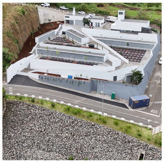
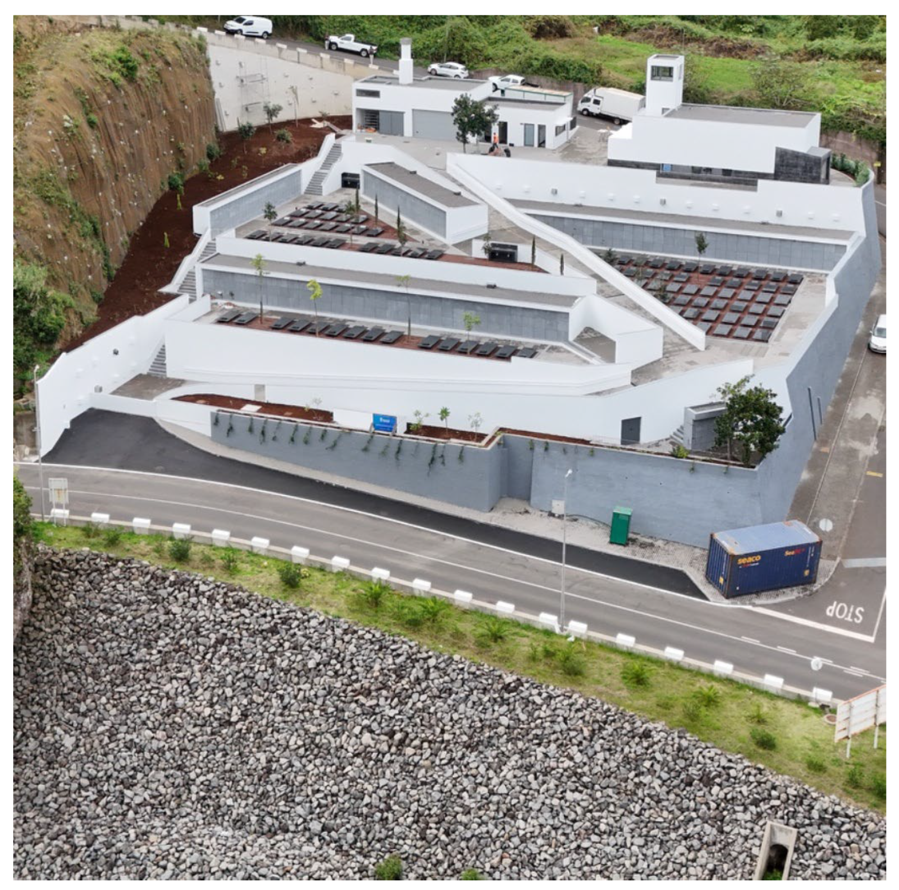
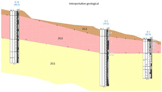
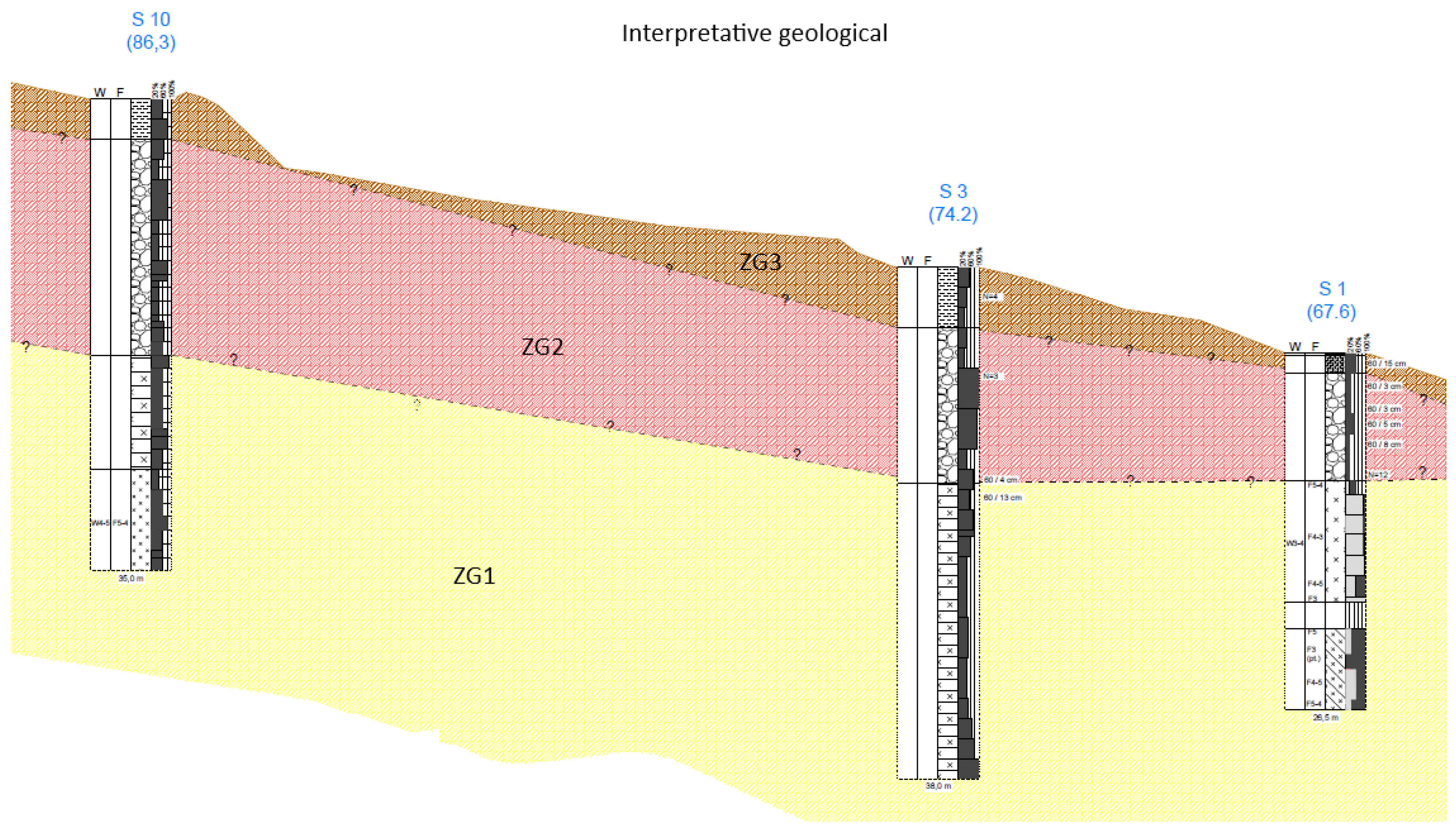
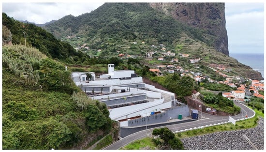
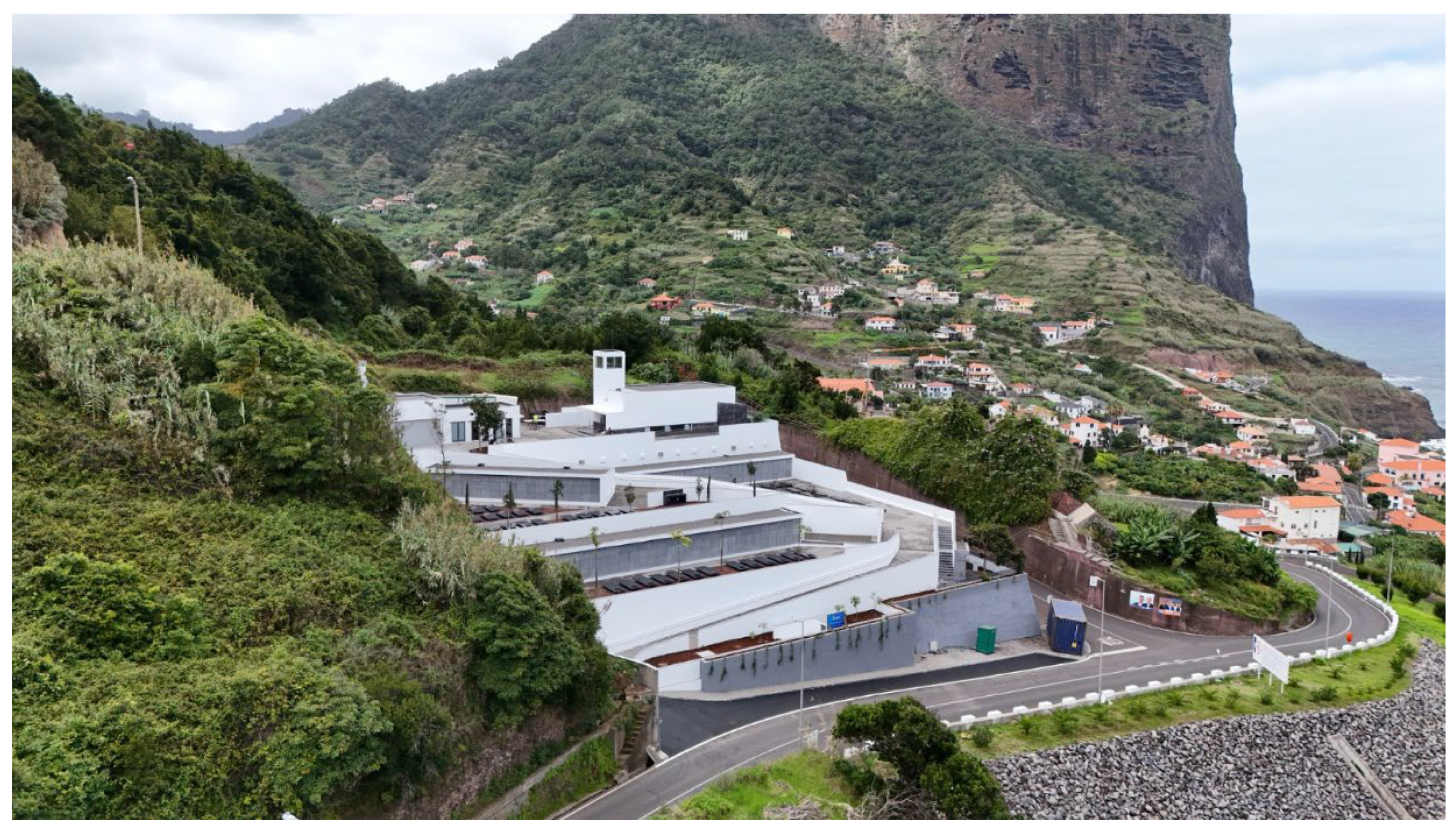
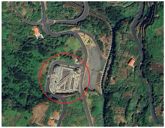
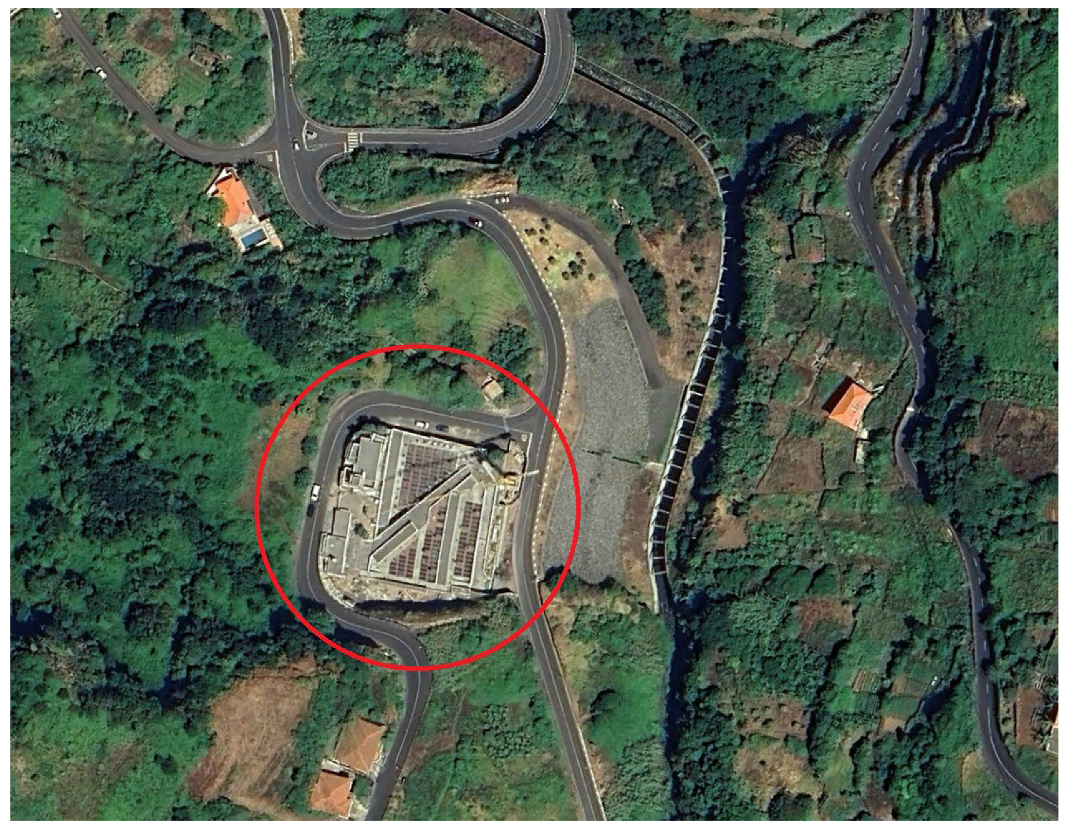
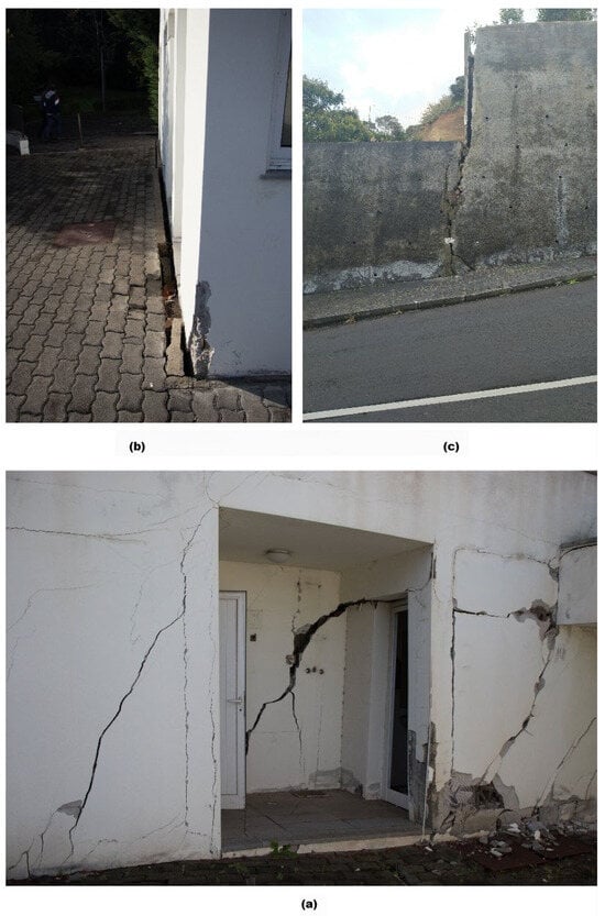
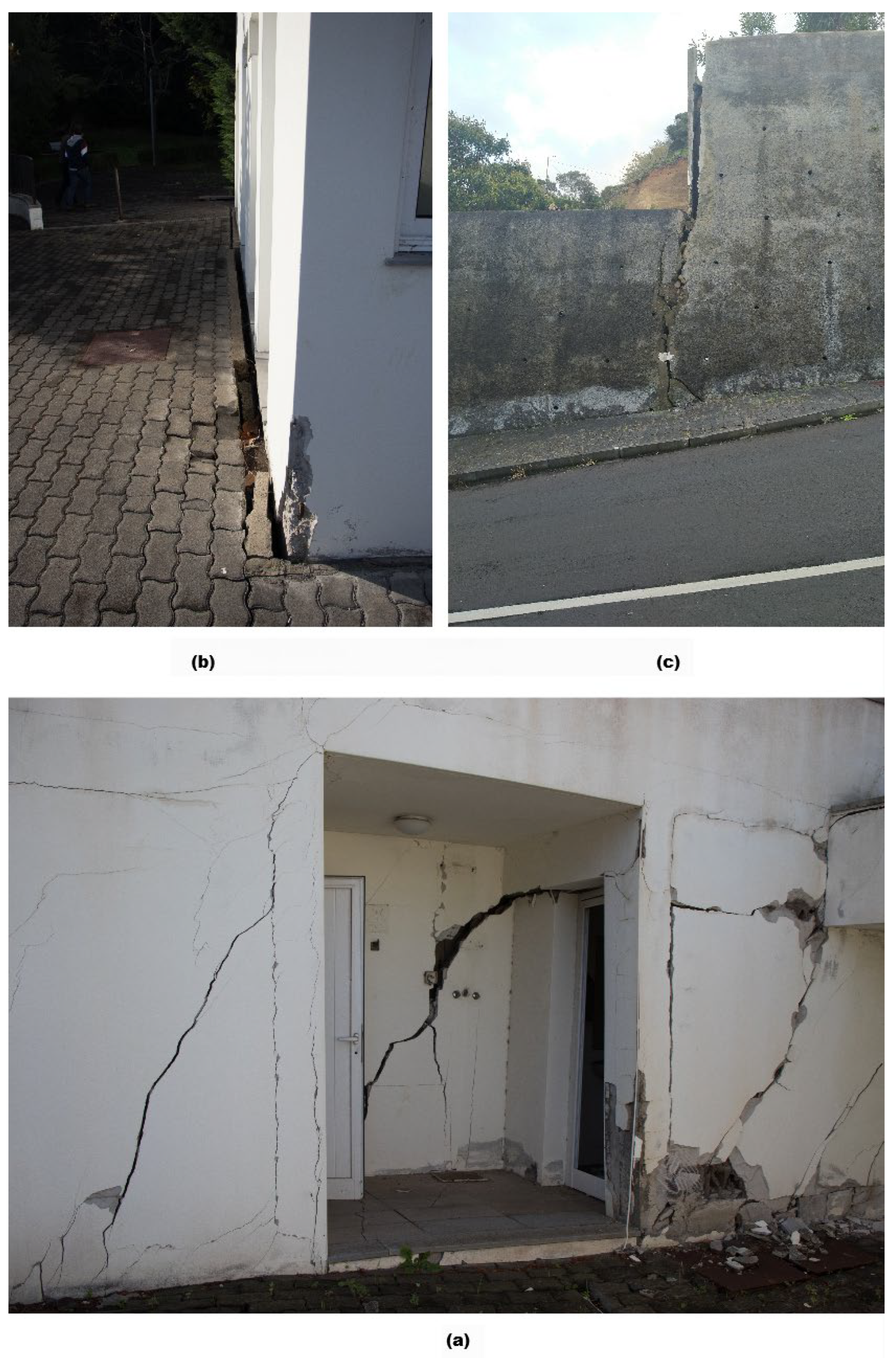
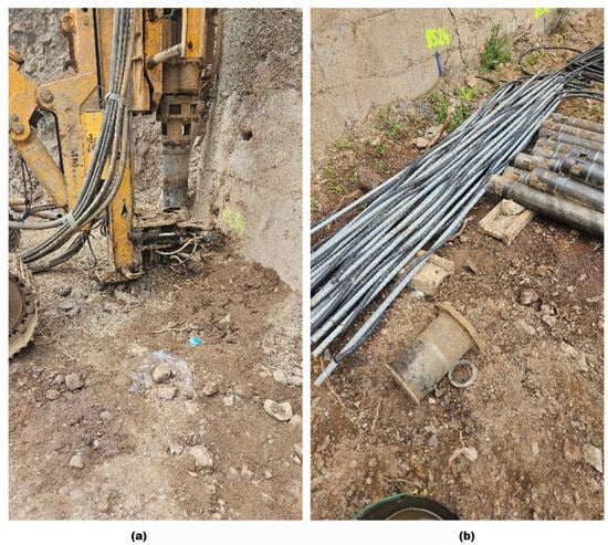
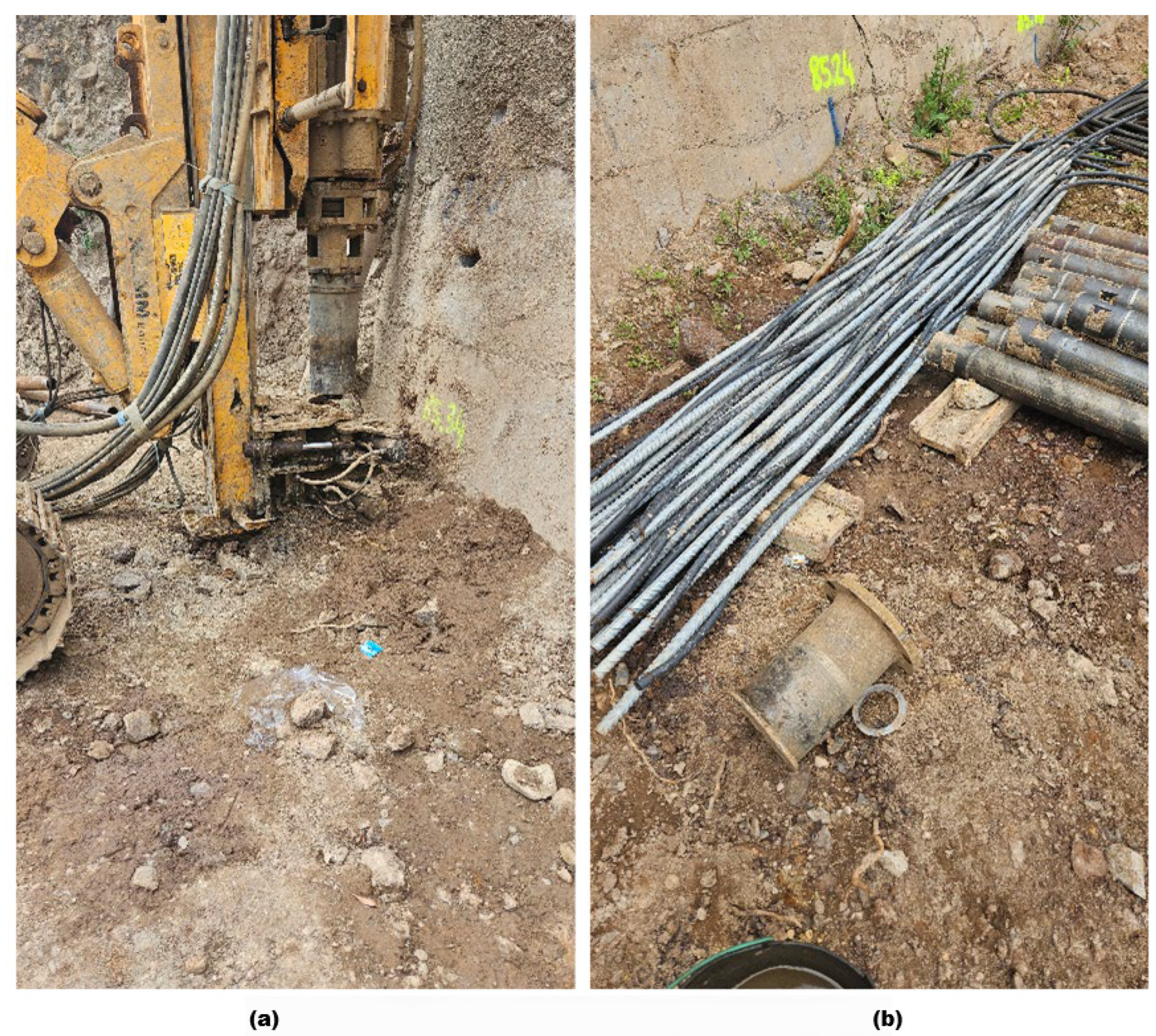
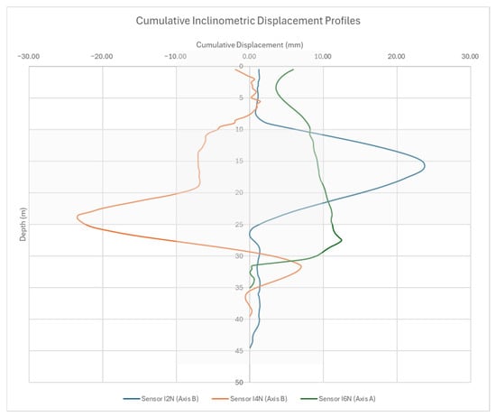
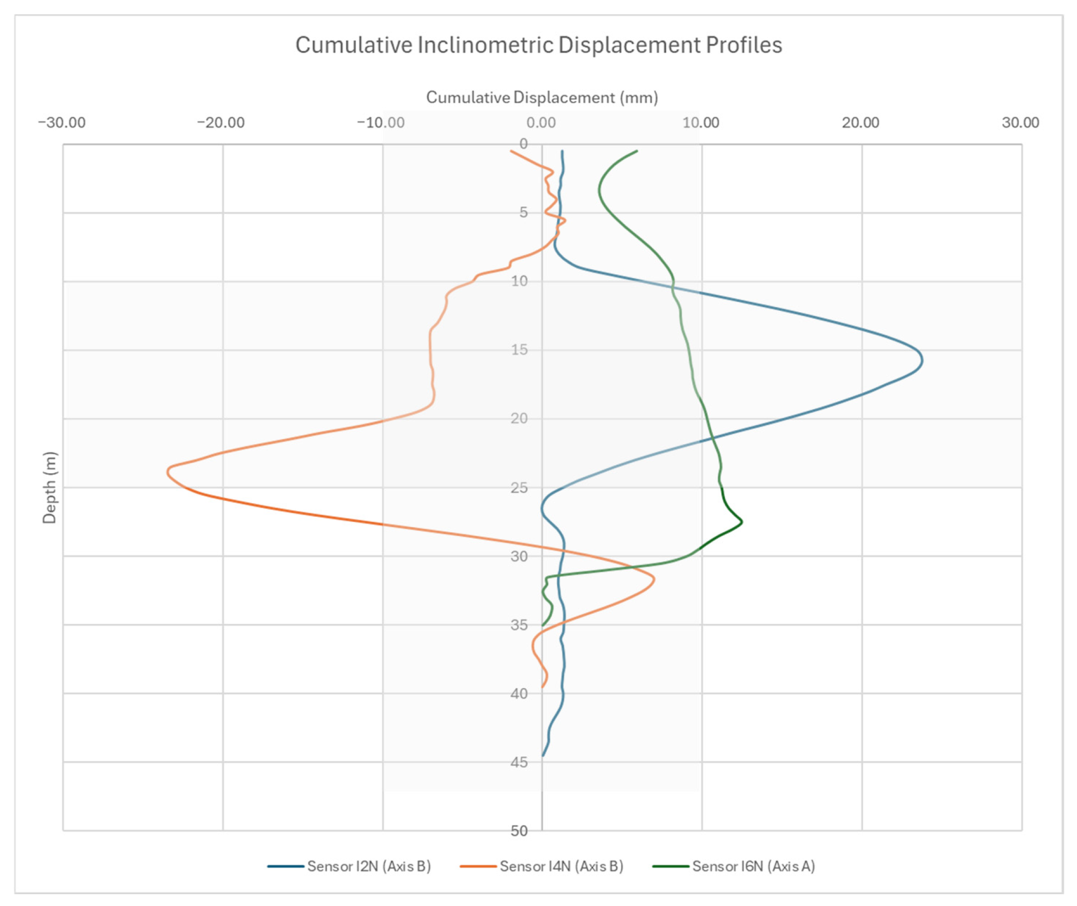

Disclaimer/Publisher’s Note: The statements, opinions and data contained in all publications are solely those of the individual author(s) and contributor(s) and not of MDPI and/or the editor(s). MDPI and/or the editor(s) disclaim responsibility for any injury to people or property resulting from any ideas, methods, instructions or products referred to in the content. |
© 2026 by the authors. Licensee MDPI, Basel, Switzerland. This article is an open access article distributed under the terms and conditions of the Creative Commons Attribution (CC BY) license.