


Abstract
This paper examines the impact of the 1923 Turkish–Greek Population Exchange on the urban and architectural heritage of Tirilye, a historic coastal settlement in Bursa, Türkiye. The study addresses how migration-related transformations shaped both the tangible and intangible dimensions of heritage, focusing particularly on traditional houses and their adaptive reuse strategies. The research aims to identify patterns of continuity and transformation in residential architecture and to interpret population exchange heritage as a multi-layered cultural process. The study adopts a qualitative multi-method approach combining literature review, archival research, field surveys, architectural and typological analyses, and oral history interviews. The monuments and twenty-eight traditional houses were comparatively analysed at urban and building scales in terms of plan organisation, façade typology, construction techniques, and functional transformation. The findings demonstrate that Tirilye largely preserved its historic urban fabric despite demographic rupture. Traditional houses retained many original spatial and architectural characteristics while adapting to new social and economic conditions. The study reveals a hybrid architectural nature combining the effects of various living traditions and highlights the continuity of production-related spaces associated with olive cultivation and sericulture. The paper proposes understanding population exchange heritage as a dynamic process shaped by continuity, adaptation, reuse, and collective memory.
1. Introduction
Throughout history, populations have relocated—whether voluntarily or under compulsion—due to political tensions, wars and conflicts, natural hazards, and climate-related challenges. Such movements disrupt communities’ connections to their natural and built environments, result in the loss of property rights, and drastically alter the cultural heritage together with its social and economic context [1,2]. The consequences extend beyond physical displacement: collective memory becomes fragmented, dislocated, and in some cases permanently lost, severing the bonds between communities and the places that once anchored their identities [3,4].
Migration and compulsory population exchange have profoundly reshaped cultural landscapes, transforming not only demographic structures but also the meanings, uses, and conservation processes of cultural heritage [5,6]. The replacement of populations redefines both tangible heritage—such as dwellings, religious structures, and urban fabric—and intangible heritage, including collective memory, identity, and cultural traditions [7,8]. In such contexts, heritage becomes a dynamic and layered field shaped by loss, adaptation, and reinterpretation, often resulting in contested or dissonant narratives. Smith [7] argues that heritage should be understood as a cultural process rather than only as material fabric. Therefore, the conservation of cultural heritage in migration settings requires approaches that move beyond material authenticity to incorporate historical layers, collective memory, social transformation, and adaptive reuse practices [9,10].
The 1923 Population Exchange between Greece and Türkiye represents a critical historical threshold in this regard. As a compulsory and state-regulated migration—the first internationally ratified exchange of its kind—it led to the large-scale displacement of communities and the abandonment of extensive architectural heritage, including residential buildings, religious structures, and everyday spaces [5,11]. The Lausanne Convention, signed on 30 January 1923 and integrated into the Lausanne Peace Treaty of 24 July 1923, between Türkiye and Greece, implemented the compulsory relocation of approximately 1.5 million people between the two countries based primarily on religious identity fundamentally reshaping the demographic, social, and spatial structures of related regions [5,11,12]. These structures, originally shaped by the socio-cultural, economic, and religious practices of their former inhabitants, were subsequently occupied by new populations with different cultural backgrounds and spatial needs [6]. As a result, buildings were not merely preserved but were reused, transformed, and reinterpreted, reflecting the changing social and economic structures of the receiving communities [10].
In this context, population exchange heritage can be understood as a process of transformation through reuse. Rather than representing a fixed or static category of heritage, it embodies a continuous interaction between past and present users [7,9]. Existing buildings functioned as spatial frameworks within which new inhabitants reconstructed everyday life, adapting spaces to new practices while simultaneously retaining certain structural and spatial characteristics [6,10]. This process generated layered environments in which traces of previous and current users coexist. As studies on population exchange heritage demonstrate, the transformation of buildings after 1923 resulted not only in physical alterations but also in changes in meaning, use, and the spirit of place, shaped by evolving social and economic conditions [10,13].
This multi-layered nature of heritage is closely related to the concept of migration heritage, which refers to the dynamic processes through which displaced communities recreate and negotiate cultural identity across different places [14]. Heritage linked to migration is distributed across countries and should be understood as part of interconnected systems (heritage corridors) rather than isolated national assets [15]. The inherited buildings thus become carriers of multiple temporalities and identities, reflecting both discontinuities caused by displacement and continuities sustained through spatial practices, construction techniques, and everyday life patterns [14,16].
The subject of this paper is understanding the relation between migration/population exchange and heritage in historic places. This paper aims to search for the traces of population exchange heritage and understand the effects of the 1923 Population Exchange on the changing urban landscape and architectural character.
1.1. The Concept of Population Exchange Heritage
The concept of “population exchange heritage” can be defined as the multi-layered cultural heritage produced by compulsory population exchange, encompassing architectural and urban fabric left behind or re-used, and the social and memory values attached to these places by both the former and incoming communities. In this sense, it is a heritage type that explicitly combines cultural, social, architectural, and memory dimensions, and is inseparable from the lived experience of displacement, resettlement, and re-making home. Population exchange heritage should be understood as a dynamic and multi-dimensional concept that integrates material fabric with collective memory, cultural meaning, and processes of reuse and sustainability. Population exchange heritage includes settlement patterns, architectural typologies of traditional houses, as well as religious, public and technical buildings [10].
Population exchange heritage can be understood as both the material evidence of demographic rupture, property transfer, and the reuse of abandoned building stock after forced migration [17], and as a multi-layered and contested heritage carrying different meanings for former and current communities [8,10]. In the case of reused churches in Bursa, Şahin, Durak & Kıvılcım Çorakbaş [10] emphasise that exchange-related heritage should be interpreted not only as physical remains but also as places of memory shaped by plural and sometimes conflicting associations.
Value-based approaches emphasise that population exchange heritage includes both tangible and intangible dimensions, requiring adaptive reuse strategies that address social, economic, and architectural needs while preserving exchange-related meanings [10]. As demonstrated in the reused churches of Bursa, continuous use often ensured the physical survival of abandoned buildings, whereas structures left vacant rapidly deteriorated due to neglect and vandalism [10].
Migration heritage studies also approach heritage as a dynamic and transnational process shaped through adaptation and reuse. Nikielska-Sekula’s concept of “heritage in becoming” describes how inherited practices are continuously reinterpreted in new contexts, while critical heritage studies highlight how minority heritage is often incorporated into dominant narratives through selective representation and reinterpretation [14,16].
From the perspective of social sustainability and collective memory, population exchange heritage can be understood as “memory places” that preserve the identities and experiences of displaced communities [10]. For descendants of the exchange, traditional houses and religious buildings continue to function as symbolic links to ancestral homelands through return visits, family narratives, commemorations, and heritage tourism associated with collective and familial memory [11,18].
The concept of population exchange heritage is closely intertwined with the notion of dissonant heritage. Tunbridge & Ashworth [8] introduced the term “dissonant heritage” to describe the inherent discord that arises when heritage is simultaneously claimed, interpreted, or contested by different groups with divergent values, memories, and political interests. In their framework, dissonance is not an anomaly but a fundamental and unavoidable characteristic of all heritage, since the process of selecting which pasts to preserve, commemorate, or promote inevitably involves the marginalisation or exclusion of alternative narratives [9]. Graham, Ashworth & Tunbridge [19] situated this dissonance within broader geographical and political contexts, arguing that heritage operates as a resource shaped by power relations, where competing cultural and economic interests determine which pasts are valorised and which are silenced. Ashworth, Graham & Tunbridge [20] further developed this argument, demonstrating that in multicultural and post-conflict societies, heritage becomes a site of competing identity claims where the question “whose heritage?” remains perpetually unresolved. Kisić [21], drawing on case studies from South-East Europe, advanced the discourse by proposing the term “heritage dissonance” rather than “dissonant heritage,” emphasising that dissonance is not a property of specific heritage objects but a relational condition embedded in the processes through which heritage is governed, interpreted, and contested across different communities and political frameworks. Macdonald [22] extended this discourse through the related concept of “difficult heritage,” referring to pasts that are meaningful yet troublesome for contemporary self-affirming identities, arguing that all difficult heritage is dissonant, though not all dissonant heritage is necessarily difficult. Logan and Reeves [23] broadened the scope further through their examination of “places of pain and shame,” demonstrating how sites associated with painful historical episodes—including forced displacement and internment—require heritage management approaches that acknowledge competing memories and unresolved grief. Population exchange heritage, as examined in this paper, exemplifies a particularly acute form of dissonance: the same buildings, streets, and landscapes carry fundamentally different meanings for the communities who built them and the communities who inherited them through compulsory displacement.
In population exchange contexts, dissonance operates at multiple levels. At the material level, buildings originally designed for one community’s religious, domestic, and economic practices are adapted to serve the needs of another, creating physical palimpsests where traces of former and current users coexist in tension. At the symbolic level, the same structure may represent ancestral homeland and loss for displaced descendants while simultaneously embodying home and belonging for the settled community. At the political level, decisions regarding what to preserve, rename, demolish, or restore reflect broader negotiations over national identity and collective memory [8]. As Smith [7] argues, heritage is not merely a set of material objects but an active cultural process through which communities construct and contest meaning [7]. The 1923 Population Exchange produced precisely such conditions of dissonance across the Aegean, where entire settlements changed hands, and the built environment became a contested medium through which both Turkish and Greek communities have continued to negotiate belonging, memory, and identity [5]. Understanding population exchange heritage through the lens of dissonant heritage, therefore, enables a more nuanced interpretation of the multi-layered and often contradictory values embedded within historic settlements such as Tirilye.
1.2. Adaptive Reuse and Physical Traces of Population Exchange
From an architectural perspective, these transformations can be interpreted within the framework of adaptive reuse. Plevoets and Van Cleempoel [9] define adaptive reuse as the process of repairing and restoring existing buildings for new or continued use, emphasising that it involves not merely a physical intervention but a process of re-evaluation between different sorts of values. In the aftermath of the population exchange, many buildings were adapted with minimal intervention due to limited economic resources, leading to hybrid spatial configurations that combined existing architectural elements with new functional requirements [10]. Within this framework, population exchange heritage can be defined as the accumulation of traces left by successive processes of reuse and adaptation. It reflects the transformation of buildings and building techniques in response to shifting cultural, social, and economic conditions, while also preserving certain spatial and material continuities [9,10]. In the context of population exchange, this dual character—simultaneously representing change and persistence—positions population exchange heritage as a multi-layered cultural process rather than a static historical category [7,8]. This study focuses on the traditional houses of Tirilye (Bursa, Türkiye), a settlement significantly affected by the 1923 Population Exchange. By examining the spatial, functional, and material transformations of these houses, the research aims to explore how processes of reuse have generated layered architectural environments. The study interprets Tirilye’s built environment as a dynamic field shaped by continuity, reuse, and transformation after the population exchange. Through this approach, the study seeks to contribute to the understanding of population exchange heritage and to highlight the role of adaptive reuse in sustaining and reinterpreting the built environment in post-migration contexts [5,10,11].
1.3. Migration and Bursa
Bursa has historically been shaped by multiple migration waves and is widely known as a “city of migration” [24,25]. Among these, the 1923 Turkish-Greek Population Exchange significantly transformed the demographic, social, and spatial structure of the city and its surrounding settlements [12,17,26]. Following the Treaty of Lausanne in 1923, large numbers of Muslim migrants were resettled in Bursa and its coastal settlements, including Tirilye, while the Greek population left the region [17,24,25].
Before the population exchange, Bursa had a multi-ethnic and multi-religious social structure in which Turkish, Greek (Rum), Armenians, and other communities coexisted and contributed to local economic activities such as trade, agriculture, silk production, and olive cultivation [17,24,25,27]. After the exchange, the reuse of existing buildings and settlement patterns by incoming populations reshaped the urban landscape and everyday life, while also generating new layers of cultural continuity and transformation [10,17].
Tirilye represents one of the settlements where the spatial and architectural effects of this demographic transformation can still be observed in the preserved urban fabric and traditional residential architecture [24,28,29].
1.4. Research Gap and Contribution
Previous studies on Tirilye have primarily focused on the historical development of the settlement, monumental buildings, urban conservation, industrial heritage, and the socio-cultural impacts of the 1923 Population Exchange [24,28,29,30,31,32,33,34,35]. Several studies documented the traditional urban texture, religious structures, olive oil production facilities, and the multicultural nature of the settlement before and after the exchange [28,29,33,36,37,38]. Research on population exchange heritage in Türkiye has also examined themes such as collective memory, migration, identity, and dissonant heritage [3,4,7,10,14].
However, limited attention has been given to the transformation of traditional houses as layered heritage environments shaped by demographic change, reuse, and everyday life after the population exchange. Existing studies generally address either the architectural characteristics of vernacular houses or the socio-historical aspects of migration separately, while the relationship between spatial transformation, oral narratives, and intangible dimensions of residential heritage remains underexplored [28,29,39,40].
This study addresses this gap by examining how traditional houses in Tirilye reflect both continuity and transformation after the population exchange through architectural analysis, field surveys, and oral narratives. By focusing on residential spaces rather than monumental heritage alone, the study evaluates how adaptive reuse, changing domestic practices, and collective memory are embedded within the preserved urban fabric. In this respect, this paper proposes an integrated approach that combines tangible and intangible dimensions of population exchange heritage within the context of vernacular residential architecture [10,14].
The research questions guiding this study are as follows:
- How did the 1923 Population Exchange reshape the urban and architectural heritage of Tirilye in the post-exchange period?
- What are the physical and cultural aspects of the transformation of Tirilye’s pre-exchange traditional residences?
- What similarities and differences can be identified between housing typologies constructed before and after the population exchange?
- Which tangible and intangible dimensions of population exchange heritage can be identified in Tirilye’s urban and architectural heritage?
2. Materials and Methods
This study adopts a qualitative, multi-method research design grounded in historical inquiry and case study methodology to investigate population exchange heritage through the transformation of traditional houses in Tirilye. The research conceptualises population exchange heritage not as a static category but as a process of continuity and transformation shaped through adaptive reuse, social change, and evolving cultural meanings [7,9]. Accordingly, the methodology integrates architectural analysis, urban morphology, archival research, and oral history to capture both tangible and intangible dimensions of heritage.
The study follows an interpretive and comparative framework, combining spatial analysis with historical reconstruction. This approach is consistent with recent studies on migration-related heritage and adaptive reuse, which emphasise the need to analyse built environments as layered and evolving socio-spatial constructs rather than fixed artefacts [9,10]. The triangulation of multiple data sources—a central principle in case study methodology—enhances the credibility and reliability of qualitative findings by enabling the phenomenon to be examined from multiple perspectives [41,42].
Tirilye was selected as a case study due to its well-preserved traditional urban fabric, its direct exposure to the 1923 Population Exchange, and its representation of Bursa as a “city of migration” [24]. The settlement provides a suitable context to examine how architectural continuity and transformation coexist within a multi-layered heritage landscape.
2.1. Methodology
The research is based on the triangulation of multiple data sources, including literature review, archival research, field survey, and oral history (Figure 1).
Figure 1.
The schema showing the methodology of the study (prepared by authors).
First, an extensive literature review was conducted on migration heritage, population exchange, adaptive reuse, and the architectural characteristics of Tirilye. The review encompassed both theoretical literature—including works on dissonant heritage [8], heritage as cultural process [7], sites of memory [4], collective memory [3], adaptive reuse, and spirit of place [13]—and empirical studies directly related to the case. Previous academic studies [28,29,36,43] on Tirilye’s urban fabric and residential typologies were used as primary data sources, particularly for typological and morphological comparisons. Research on the 1923 population exchange and its broader consequences [5,17] provided the historical framework for interpreting architectural transformations.
Second, archival research was carried out to reconstruct the historical and spatial transformations of the settlement. This included the examination of cadastral records (where accessible), historical photographs, population data drawn from published Bursa Yearbooks (Hüdavendigar Vilayeti Salnamesi), and secondary historical sources [24,30,44,45]. These materials were used to identify pre- and post-exchange conditions and functional changes in buildings. Third, field surveys were conducted to document the current physical condition and architectural characteristics of traditional houses. The survey included photographic documentation, on-site observation, and architectural recording of 28 selected buildings within the conservation boundaries of Tirilye.
Fourth, oral history was employed to capture the intangible dimensions of population exchange heritage, including collective memory, everyday practices, and narratives related to building use and transformation. Oral interviews were used to complement archival gaps and to understand the lived experience of spatial change, providing insights into how successive generations have inhabited, adapted, and assigned meaning to inherited buildings. During the fieldwork, students conducted a limited number of oral interviews with 5 local people who are owners or neighbours of selected houses [46,47,48,49,50]. Another person interviewed by the authors is a Greek researcher and Tirilye descendant [40].
Artificial intelligence tools, including ChatGPT 4.2 (OpenAI, 1455 3rd Street, San Francisco, CA 94158, USA) and Claude Opus 4.6 (Antrophic PBC, 548 Market Street PMB 90375 San Francisco, CA 94104, USA), were partially utilised during the preparation of this manuscript for translation, language editing, structural organisation, and academic writing support. No AI-assisted tools were employed in the processes of data collection, analysis, or interpretation. In addition, Google Gemini was used to enhance the visual quality of the plan drawings reproduced from Akgün B.’s (1995) [28] master’s thesis and to implement minor graphic modifications, such as the removal of unnecessary colours and textual elements. Adobe Acrobat Pro DC (Adobe, 345 Park Avenue, San Jose, CA 95110-2704, USA) was further employed to process the PDF-format plan drawings reproduced from Doğan Tavas’s (2021) [29] master’s thesis.
2.2. Spatial and Architectural Analysis of Tirilye Houses
The spatial and architectural analysis was conducted through a multi-scalar approach, integrating both urban and architectural levels to examine continuity and transformation in traditional houses. Such an approach enables the identification of patterns operating across different spatial scales, from the settlement structure to individual dwellings [51,52].
At the urban scale, the study focused on the morphological characteristics of Tirilye, including the street network, topographical adaptation, parcel organisation, and the distribution of residential and mixed-use structures. In this paper, urban characteristics of Tirilye were studied and interpreted based on former works on Tirilye’s urban fabric conducted by Yılmaz Akyıldız [36], Doğan Tavas [29] and the authors between 2013 and 2015. Furthermore, existing analyses are updated during field studies of Historical Building Analysis course students in 2023 and the authors in 2025–2026. Drawing on urban morphology theory [51,52,53], this analysis reveals how settlement patterns have evolved in response to socio-economic and cultural dynamics. Particular attention was given to functional transformations within the urban fabric, such as the conversion of residential buildings into commercial or tourism-related uses, interpreted within broader processes of adaptive reuse and changing livelihoods [9,31].
At the architectural scale, the analysis addressed plan organisation, vertical spatial hierarchy, façade composition, and construction techniques. Typological analysis, a well-established method in architectural history [54], enabled the classification and comparison of houses based on shared spatial and formal characteristics. Plan typologies—especially the relationship between ground and upper floors and the configuration of circulation spaces called sofa—were examined using existing scholarly sources on Tirilye [28,29,36], which provide systematically documented drawings.
Façade analysis was based on field documentation produced within the Historical Building Analysis course at Bursa Uludağ University [55]. Students conducted measured drawings and photographic surveys, supported by archival research and literature review. Restitution drawings were prepared to understand and present original façade conditions, allowing for a comparison with the current states. This method enabled the identification of alterations such as additions, material changes, and modifications of openings, following established conservation approaches [56,57].
The integration of archival research, previous studies, and new fieldwork provided a comprehensive understanding of both spatial organisation and architectural transformation, highlighting how buildings have been continuously adapted while maintaining typological continuity.
2.3. Data Collection and Case Selection
The case study in this article comprises 28 traditional Tirilye houses built in the late 19th century and/or during the 20th century, including the interventions of new users’ lifestyle after the 1923 Population Exchange. The selected 28 traditional houses represent Tirilye’s housing culture related to its urban landscape, construction styles and the diversity of residential architecture in terms of plan typology, façade organisation, and construction period. The selection of buildings for detailed analysis was guided by criteria including the availability of archival material compiled from archival sources, published studies, and recent fieldwork. Houses were included based on one or more of the following criteria:
- Representatives of the architectural diversity of traditional Tirilye houses that have not undergone recent restoration interventions and therefore preserve a high degree of authenticity despite transformations over time.
- The physical integrity and legibility of the fabric, the diversity of reuse trajectories, and accessibility to memory holders.
- The availability of reliable visual documentation (photographs and/or façade drawings).
- The presence of plan and façade data or typological classification in previous studies.
- Identifiable chronological attribution (pre- or post-population exchange) based on archival records, registration status, or oral history.
In addition, documentation studies of 20 traditional houses produced by undergraduate students at Bursa Uludağ University, Faculty of Architecture, Department of Architecture, 2023–2024 Fall Semester, Historical Building Analysis (Tarihi Yapı Çözümleme [TYÇ] in Turkish), Section B, Undergraduate Course [55], were incorporated into the dataset with permission from the students. This supplementary fieldwork provided measured drawings and photographic records that enriched the primary data. In addition to the documented 20 houses, another 8 houses, which represent the architectural diversity of Tirilye houses and were documented by other researchers [28,29,36], are selected to enlarge the case study. So, a total of 28 houses were studied in this paper.
The dataset comprises three temporal categories: pre-exchange, post-exchange, and “chronologically uncertain”. While priority was given to clearly dated examples, uncertain cases were also included to capture the broader morphological range of the settlement.
The selected houses were analysed using a comparative typological framework, focusing on ground-floor plan, top-floor plan, and top-floor façade organisation. Some of the houses contain mezzanine floors, the configurations of which vary according to topographical conditions, spatial location, and functional requirements. As neither the mezzanine floor layouts nor their corresponding façade characteristics exhibit a consistent typological pattern, they were excluded from the comparative typological analysis conducted within the scope of this study. Each case was classified according to the number of spaces on the front façade (one-, two-, or three-space) and the configuration of projections (e.g., double-corner, single-sided, full-storey, serrated). This framework enables the identification of both recurring patterns and period-specific tendencies, while acknowledging limitations related to incomplete documentation and varying preservation conditions.
The interpretation of findings is guided by a conceptual framework combining four interrelated theoretical perspectives. First, adaptive reuse and conservation-through-use approaches provide the lens through which physical transformations of buildings are evaluated, emphasising that the continued use of historic structures is often the most effective means of ensuring their survival [9,56]. Second, the concepts of contested heritage [58] and dissonant and multi-layered heritage [8] offer a framework for understanding the competing and sometimes conflicting meanings that different communities attach to the same built environment. Third, migration heritage, heritage corridor, and heritage-as-process approaches [7,14,15] direct attention to the dynamic, performative, and transnational character of heritage practices in contexts of displacement. Fourth, the concept of socio-spatial transformation in migration contexts [15] provides insight into how migration reshapes territory, identity, and cultural memory through the construction and modification of dwellings.
This framework enables the evaluation of buildings not only as physical objects but also as carriers of cultural memory, identity, and socio-economic change. In line with recent studies on population exchange heritage, the research interprets architectural transformation as a cumulative process reflecting both continuity and rupture [10,59].
2.4. Limitations
This study is subject to certain limitations that should be acknowledged. Access to archival materials, such as cadastral records, was partial and historical maps were not found, and some data rely on secondary sources. Oral history data are selective and depend on the availability and willingness of participants; as with all oral testimony, these accounts are subject to the selective and reconstructive nature of memory [3,39]. Most of the 28 selected houses are either abandoned or used only seasonally during the olive cultivation period, while only a few remain occupied throughout the year. For this reason, the students and authors were able to interview only five residents during the field study conducted in November 2023. In addition, the current residents—whether owners or tenants—are not the original or early post-exchange users who carried out the initial interventions to the houses after the population exchange.
The documentation produced by undergraduate students, while supervised and verified, may not achieve the precision of a professional architectural survey. Despite these constraints, the use of multiple data sources and cross-verification through triangulation enhances the reliability and credibility of the findings [41,42].
This methodology enables a comprehensive reading of Tirilye’s traditional houses as products of a multi-layered cultural process, where adaptive reuse serves as the key mechanism through which population exchange heritage is materialised and continuously reinterpreted [7,9,10].
2.5. Tirilye and the Population Exchange
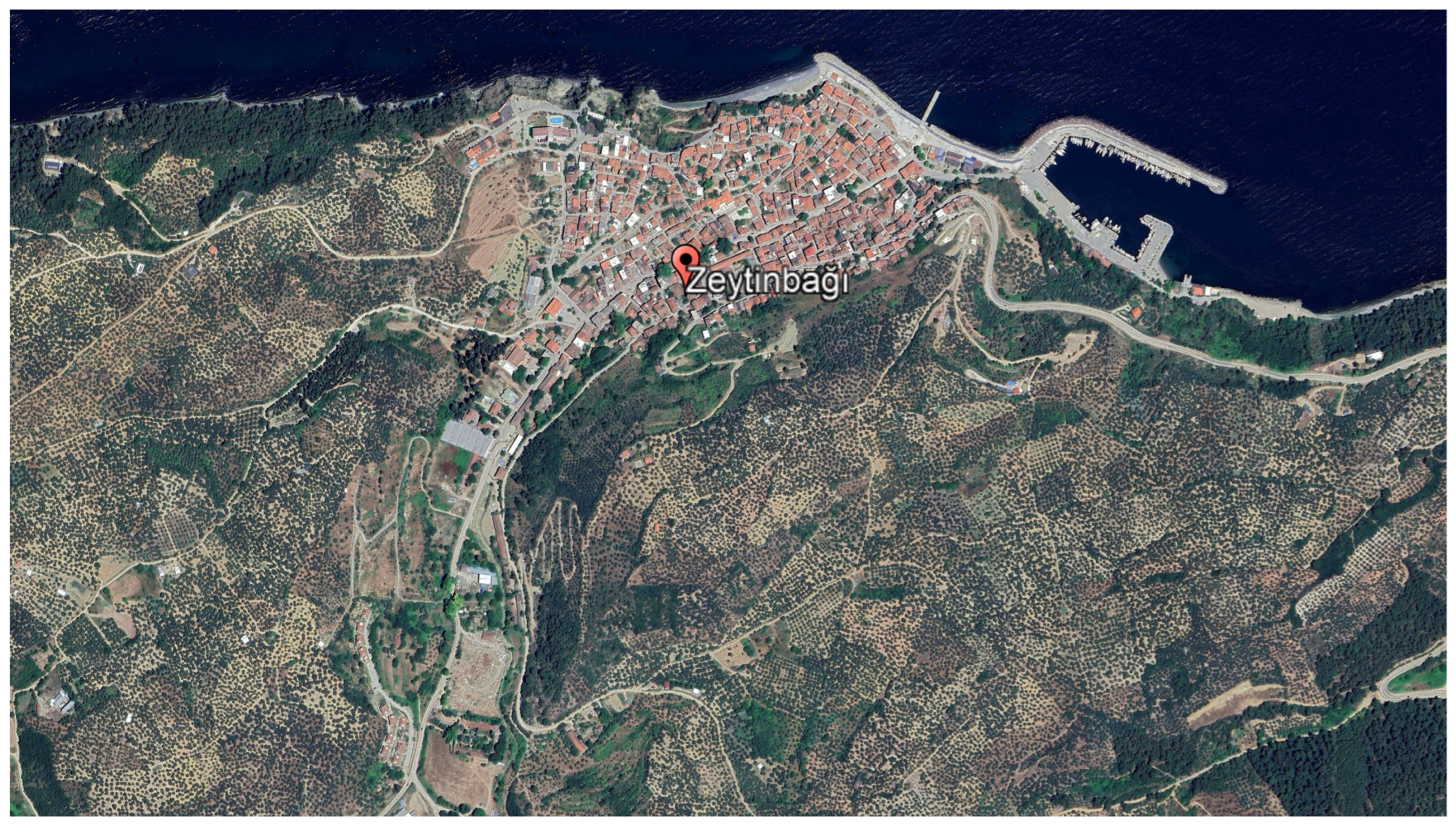
Tirilye is a historic coastal settlement located on the southern coast of the Marmara Sea in Bursa, Türkiye, within a valley surrounded by olive landscapes (Figure 2). Throughout its history, the settlement hosted Roman, Byzantine, and Ottoman communities, resulting in a multi-layered cultural and architectural heritage [32,33,37]. Before the 1923 Population Exchange, Tirilye was predominantly inhabited by a Greek (Rum) population, while Muslim residents constituted a minority [24,28,29,45,60,61]. Following the Lausanne Treaty and the compulsory exchange between Greece and Türkiye, the Rum population left the settlement, and Muslim migrants—particularly from Crete and other parts of Greece—were resettled in the existing housing stock and agricultural lands [24,28,29,62,63]. This demographic transformation significantly altered the social structure of Tirilye, while the physical urban fabric largely remained intact. The settlement historically was known as “Caesarea” or “Bryllios/Brylleion” in ancient and Byzantine periods [32]. The name “Trigleia” became widespread after the establishment of the Trigleia Monastery during the Byzantine era [64]. The settlement was later officially renamed “Zeytinbağı” in 1963 and “Tirilye” in 2012, although the original name continued to be used locally for decades [33,37,60]. Historical records and Bursa yearbooks indicate that Tirilye was predominantly inhabited by a Greek (Rum) population before the 1923 Population Exchange, while Muslim residents constituted a minority [24,28,29,45,61]. For example, according to published archival records, the settlement had a population of 4131 in 1900, of which 3878 were non-Muslim inhabitants [24,30,45]. Following the Population Exchange, Muslim migrants from Crete, Thessaloniki, Serres, Alexandroupolis, and surrounding regions were resettled in Tirilye and nearby settlements [24,28,63]. Greeks who left Tirilye established the settlement of Nea Triglia (New Tirilye) near Thessaloniki in Greece [24].
Historically, the local economy was based on olive cultivation, olive oil production, sericulture, fisheries, grape farming, and trade activities, with olive production remaining the dominant economic activity over time [65,66]. The traces of these production activities are visible in the built environment through olive oil workshops, storage buildings (mağaza), mixed-use shop-houses, and industrial structures such as the late nineteenth-century olive oil factory, which represents an important example of industrial heritage in Bursa [30,31,33,35,37,38]. Following the Population Exchange, Muslim migrants from Crete, Thessaloniki, Serres, Alexandroupolis, and surrounding regions were resettled in Tirilye and nearby settlements [24,28,63]. Greeks who left Tirilye established the settlement of Nea Triglia (New Tirilye) near Thessaloniki in Greece [24]. According to Sakellaridis [34] and Mytilineou [35], Tirilye experienced significant urban and educational development between the late nineteenth and early twentieth centuries, including the construction of schools, churches, infrastructure works, and large residences associated with commercial prosperity.
Today, Tirilye retains much of its historic urban texture and vernacular architectural character despite socio-economic transformation and changing patterns of use [28,29,36]. Traditional houses, religious buildings, industrial structures, and olive landscapes collectively reflect the layered heritage produced through continuity, reuse, and adaptation after the population exchange [10,14]. The transformation of traditional houses preserved traces of social memory and domestic practices before and after the population exchange. Certain intangible practices associated with olive cultivation, domestic production, culinary traditions, and collective memory continue to survive in transformed forms within the settlement [61,63,67,68]. Previous studies documented several intangible cultural practices in Tirilye, including culinary traditions, communal celebrations, maritime activities, and everyday social customs associated with both Rum and Cretan migrant communities [61,63,67,68]. Some traditions continue today in transformed forms through oral memory and local cultural practices [28].
Figure 2.
The satellite map of Tirilye (Zeytinbağı) showing the urban landscape and its location in the Marmara region (adopted by authors based on Google Earth satellite map [69]).
2.6. Historic Urban Landscape of Tirilye
The townscape is defined by a valley opening toward the Sea of Marmara on the north and the surrounding olive landscape (Figure 3). Buildings in the settlement are primarily oriented toward views of the Sea of Marmara and the valley slopes (Figure 4). Although the vineyards and mulberry trees once used for silkworm breeding no longer exist, the olive groves remain a key feature of the area.
Figure 3.
A general view of Tirilye urban landscape, looking from the west part of the valley to the east (Fatih Mosque and its minaret [left] and surroundings olive landscape [right]).
Figure 4.
A photograph of Tirilye at the beginning of the 20th century, after 1912, looking from west to east (this photo, published in the Atlantis newspaper in New York on 21 November 1915, is taken from a Greek website on Tirilye [70]).
Tirilye’s road network is shaped by its steep, sloping terrain. Main streets follow the topography and creek, while secondary streets connect perpendicularly through steep roads, public stairs, and stepped pathways. Although the layout is largely linear, it occasionally develops into an organic pattern [29].
In the past, the main transportation axis of the settlement was Eski Pazar Street, where Taş Mektep (historic school), post office, and many houses with shops (dükkan) were located. According to Mytilineou [35], the years between 1880 and 1914 were the best period for Tirilye when many urban works were completed, such as constructing new big houses, a new school (Taş Mektep) and factories, repairing churches and schools and urban infrastructure such as lighting the streets with oil lamps, a small dam near the Çifte Çeşmeler and street arrangements. İskele Street, Tirilye’s main axis at present, was arranged by covering up the Manastır Deresi (Monasty Stream) that was running through the settlement. Half of the streams were covered in 1902 [35], and later the remaining parts were covered in 1930s and 1950s [71,72]. Moreover, according to the works of V. Sakellaridis [34] and E. Mytilineou [35], who are researchers and children of Triglian Descendants, two traditional houses on İskele Street, lot number 2227/6-7, were the former seven-class boys’ schools and lot number 2227/9 was a girls’ school in the late 19th century. These schools had been used until Taş Mektep was built in 1909–1912. In addition, there were two kindergartens built separately from the boys’ and girls’ schools. This paper shows that Tirilye people gave great importance to the education of students and their teachers [34].
Tirilye was officially designated as a protected urban site by the Bursa Council for the Conservation of Natural and Cultural Monuments in 1981. In 1989, the Municipality of Zeytinbağı (the former name of Tirilye) prepared the first conservation-oriented zoning plan, which was approved and came into force in 1990 [29].
The traces of olive cultivation, which have underpinned the economy in the past and present, can be seen in urban space as oil mills and olive depots (mağaza). The modern olive oil factory in the late 19th century is one of the unique architectural examples in Tirilye as well as in Bursa. At present, Mudanya Municipality has owned the two registered factory buildings on Karacabey Street since 2025 and is conducting an ongoing conservation project to restore them and use them as a museum. The additional buildings in the backyard and the garden still belong to the Lofçalıoğlu family and their heirs. According to Mudanya Land Registry records, the factory was registered as an “olive oil factory and uncompleted flour mill” and transferred to the Lofçalıoğlu family after the 1923 Population Exchange. In 1972, Tirilye Agricultural Advance Cooperative purchased the two main buildings and added two small structures near the northeast façade of the olive oil factory [33,37,65]. Acar Bilgin & Köprülü Bağbancı [65] state that the first section was built in the 19th century as an olive oil workshop powered by humans and animals, while the second section and brick chimney were later added for steam engine operation. Recent findings indicate the complex dates to the late 19th century and also included a flour mill. The factory produced olive oil and flour distributed via Mudanya port to Istanbul, Izmir, Bucharest, Marseille, and Russia [35].
2.7. The Architecture of Traditional Tirilye Houses
The traditional houses of Tirilye represent a distinctive architectural typology that emerged from the interplay of topographical constraints, climatic conditions, economic activities, and the multicultural social fabric of the settlement. Understanding their characteristics requires situating them within the broader discourse on Anatolian vernacular housing, particularly the typological frameworks established by Eldem [73], Kuban [74,75] and Şahin Güçhan [76].
Şahin Güçhan [76], building on the typological studies of Eldem [73] and Kuban [74], classified Bursa-region timber-frame (hımış) houses as part of the “original Anatolian synthesis” typology. Kuban [74] described the hımış technique of Western Anatolia as a culturally rooted architectural contribution of the Turks. Traditional Anatolian houses are generally inward-looking, with privacy-oriented plans, distinct functional divisions between floors, and spatial organisation centred on the sofa and multifunctional rooms. Semi-open and open spaces such as courtyards, taşlık (stone-paved ground-floor hall), eyvan (a raised space in sofa or between two rooms), and gardens are typically oriented inward rather than toward the street [73,74,76]. By contrast, some nineteenth-century houses featured a cihannuma, a roof-level room or semi-open space with panoramic views through multiple windows [77]. Akgün [28] compared Tirilye houses with the traditional Turkish house and the outward-oriented “Chios type” houses of Aegean Greek settlements. While the traditional Turkish house is inward-oriented with the sofa as a communal living space, the Chios type is street-oriented and uses the sofa mainly for circulation. Balconies in Chios-type houses appear in three forms: between corner projections, in front of a room, or as a central façade projection [28]. This comparison shows that Tirilye houses have a hybrid nature, combining features of both Anatolian Turkish and Aegean Greek housing traditions. Tirilye houses share construction techniques and general structural principles with the broader Bursa housing tradition, both employing the timber-frame (hımış) system [28,29]. However, significant differences distinguish Tirilye from other Bursa-region settlements. While gardens and courtyards are standard features of Bursa houses, most Tirilye houses lack gardens altogether, and where gardens do exist, they do not play a dominant role in domestic life [28]. This can be attributed to the settlement’s steep topography and dense urban fabric, which limited the available buildable land and discouraged the proliferation of open courtyard spaces. Buildings generally cover nearly the entire parcel, leaving little open space beyond occasional narrow rear gardens [29]. The use of projections (çıkma) and balconies to enlarge interior spaces enabled the creation of rectangular rooms in the upper storeys of houses situated on irregular and narrow plots [30,33,37]. Structurally, the houses are typically timber-frame constructions with rubble stone, mudbrick, or fired brick infill walls on stone masonry bases, with some ground floors built entirely in masonry [30,33,37]. Façades are characterised by distinctive projections extending toward the street, while balconies and terraces—though they contribute to the architectural identity of the settlement—are used relatively rarely [33,37].
Akgün [28] argued that, despite having been built by two communities with different lifestyles—the Greek (Rum) and Muslim populations—Tirilye houses exhibit sufficient similarities to render typological separation impossible. However, this assessment warrants qualification. While construction techniques and building materials are indeed shared, notable differences emerge in plan typology, the functional use of floors, and the building’s relationship with the street. Features such as the incorporation of balconies and the absence of courtyards in the spatial organisation of Rum houses distinguish them from the Muslim houses of Tirilye, suggesting that cultural practices and social norms exerted a discernible influence on domestic spatial configurations even within a shared material and structural framework.
Tirilye houses integrated shops (dükkan), olive processing spaces (mağaza), and areas dedicated to sericulture alongside domestic living quarters. The spatial elements associated with the settlement’s historically important economic activities—winemaking, sericulture (kozacılık), and olive cultivation—are reflected in the domestic architecture [28,29]. Notably, before the population exchange, the upper floors of houses were used for breeding silkworms to produce cocoons, an activity that constituted a significant source of income for women [35].
Traditional Tirilye houses were multifunctional building that integrated sericulture, one of the settlement’s major historical economic activities, into their domestic organisation [28,29,36]. Various spaces within the houses, particularly attic areas, roof voids, mezzanine floors (ara kat), and some gallery spaces, were used for silkworm breeding [28,29]. Mezzanine floors, located between the ground and upper floors, were especially associated with sericulture and fruit drying, generally consisting of open sofa spaces suited to productive activities [29,43]. The humid and temperate climate of Tirilye, favourable for both olive cultivation and sericulture, strongly influenced the architectural character of the houses, shaping them as locally responsive building types. Architectural elements related to sericulture also demonstrate how domestic and economic functions were closely intertwined within the settlement’s housing culture [28,29]. From the 1950s onward, however, the economic importance of sericulture gradually declined as olive cultivation and changing production methods became more dominant. As a result, many spaces formerly dedicated to silkworm breeding lost their original function or were adapted for other uses [28,29].
According to Mytilineou [40], many traditional Tirilye houses were altered after the population exchange. Large houses were subdivided and allocated to multiple Turkish families, leading to significant spatial and architectural modifications. In many cases, upper floors were removed and replaced with lower roofs, while façades were altered through the reduction or closure of ground-floor windows to increase privacy. Mytilineou [40] also notes that original mudbrick infill walls were frequently replaced with brick, making the structures heavier and contributing to later collapses. These interventions remain visible today through façade alterations, modified openings, and material changes [40].
3. Results
Tirilye’s urban heritage comprises a diverse range of monumental, industrial, and residential buildings that collectively bear witness to the settlement’s multi-layered history and the transformations brought about by the 1923 Population Exchange. The registered built heritage of the settlement encompasses structures dating from the Byzantine, Ottoman, and early Republican periods, reflecting the successive cultural layers that have shaped the physical environment over centuries. These buildings constitute not only architectural artefacts, but also tangible evidence of the demographic rupture and socio-cultural continuity associated with the population exchange—a process through which buildings changed hands, meanings, and functions while largely retaining their material fabric [7,10].
According to the 1990 Tirilye Conservation Master Plan Report [78], 13 monumental buildings and 134 traditional buildings—including residences, depots, and workshops—dating from the 19th and 20th centuries were registered as cultural properties. The registered monumental structures include four churches, one hammam, one historic school (Taş Mektep), four historic fountains, and the old Greek cemetery. In addition, one olive oil factory and one winery are registered as industrial heritage structures [36,45]. The ancient port area known as Kapanca, designated as an archaeological site, further attests to Tirilye’s historical significance as a coastal trade centre [79]. According to the current Conservation Master Plan, public historic buildings are classified as “monuments” while traditional residential and industrial buildings are classified as “civil architecture” under national heritage legislation [78]. In recent years, the number of registered civil architecture examples has increased to 156 (142 residential and 16 industrial) beyond the original 134 recorded in the 1990 plan, indicating growing recognition of the heritage value of the settlement’s traditional building stock.
Most of Tirilye’s monumental buildings, including its churches and monasteries, were built by the Greek (Rum) community, which made up the majority of the population for hundreds of years. Following the 1923 exchange, these buildings underwent profound functional transformations: churches were converted into mosques, residences, cultural centres, or left abandoned; the Greek school became a public cultural facility; and the winery was repurposed as a dwelling (Table 1). The olive oil factory, which continued to operate after the exchange under new ownership, exemplifies a case of functional continuity—the production activity persisted even as the social and economic actors changed, sustaining the tangible link between the settlement’s pre- and post-exchange economies [33,37,61,65].
Table 1.
The current status, functions and construction periods of registered architectural monuments in Tirilye (prepared by authors).
At the residential scale, traditional houses constitute the largest component of Tirilye’s built heritage. According to Doğan Tavas [29], the settlement contains 245 traditional houses, representing 72% of all traditional buildings within the urban conservation site boundaries, of which 96 are registered. Among these, 29 houses incorporate shop spaces on the ground floor, accounting for 8.5% of traditional buildings and reflecting the historically multifunctional character of domestic architecture in Tirilye [29]. These shop-houses (dükkânlı konut), together with olive storage warehouses (mağaza) and olive oil workshops (yağhane), represent the spatial imprint of the economic activities—particularly olive cultivation and trade—that sustained the settlement both before and after the population exchange [24,33,37,61].
Beyond the registered monuments and civil architecture examples, there remain numerous olive workshops, storage facilities, and traditional houses that have not yet been formally registered. Table 1 presents a comprehensive overview of the registered architectural monuments in Tirilye, documenting their current names and functions, original designations, construction periods, building types, and registration status, thereby providing a systematic basis for understanding the functional continuity, transformation, and loss that characterise population exchange heritage at the urban scale.
The two churches İskele Street were demolished over time. The first one was the Church of Agios Georgios Kato in the place of the park (lot number 2197/1), and the other one was in the place of the former municipality building (lot number 2193/3) [80].
As shown in Table 1, the architectural monuments inherited from earlier centuries have been protected, abandoned, and generally reused after Ottoman domination in the 14th century and after the 1923 Population Exchange. The churches and monasteries lost their function over time, or they were refunctioned and used for religious, educational, and residential purposes.
The urban map shown in Figure 5 was prepared by the authors by adopting the current base map and zoning plan taken from Mudanya Municipality in 2026 [78]. Additionally, the unregistered traditional buildings are taken from Doğan Tavas’ work [29] and updated during field work in 2023 and 2026. The current uses and names of significant buildings, which are listed in Table 1, are also shown on the map. The urban map of Tirilye shows all the existing heritage buildings, whether registered (thick contour) or not (thin contour). The buildings were painted according to their original functions in the late 19th century. Some of the traditional houses are still in use, and many of them are out of use. Industrial facilities sustained their function for a long time. Besides the registered ones, there are many industrial buildings related to olive production still present in Tirilye’s urban site.
Figure 5.
The map showing the boundary of protected areas and the original function of monuments and traditional buildings in Tirilye (prepared by authors. The numbers indicate the 28 selected houses).
The map shows that the number of registered traditional houses and industrial buildings increased from the 1990s to 2026. According to the current map, there are 4 churches and an old school (Taş Mektep), and one hammam and 16 industrial buildings (one of them is a modern factory) are registered as architectural monuments based on the national conservation law and regulations. Other buildings are registered as civil architecture examples. Another registered traditional building is 2 historic coffee shops (kahvehane in Turkish), 2 old schools. There are 288 traditional buildings, except for monuments, the old churches, Taş Mektep and industrial buildings. The remaining 284 traditional buildings are all houses, and 142 of them are registered. Among all these traditional houses, 28 of them (%10) are selected for this study.
3.1. Typological and Comparative Analyses of Architectural Characteristics of Traditional Houses
One of the most distinctive characteristics of Tirilye’s domestic architecture is the emergence of a locally specific and largely homogeneous housing culture shaped through long-term coexistence, cultural interaction, and shared everyday practices within the multicultural context of the Ottoman Empire. Muslim and Greek (Rum) communities lived together for centuries under similar climatic, geographical, and socio-economic conditions, and their daily life patterns—including production activities, neighbourhood relations, family organisation, and the use of domestic space—had many common aspects. These shared practices were reflected in construction techniques, spatial organisation, and architectural forms, resulting in housing typologies that cannot be understood through rigid ethnic or religious classifications alone.
For this reason, terms such as “Turkish house” or “Greek house” should be approached critically, since they may imply fixed cultural boundaries that do not fully correspond to the hybrid and interconnected nature of Ottoman residential architecture. The differences observed among houses were shaped not only by cultural preferences but also by broader factors such as topography, parcel structure, economic production, climatic adaptation, social status, and changing lifestyles. As noted by previous studies [28,29], the boundaries between the architectural conventions associated with different communities became increasingly blurred over time, making it difficult to distinguish buildings typologically as strictly “Greek” or “Turkish” houses. Instead, Tirilye houses should be interpreted as products of a shared vernacular tradition formed through continuity, adaptation, and intercultural exchange.
This integration is evident across several dimensions of the built form. In terms of construction technique, houses from both communities employ the hımış (timber-frame) system, though in Tirilye even the ground floors—which in the traditional Turkish house are typically built in solid masonry—frequently feature timber-frame construction, representing a localised practice adopted by both groups rather than a direct import from the Aegean “Chios type” tradition [28]. Regarding the relationship between dwelling and street, the traditional Turkish house is characteristically inward-looking, enclosed by high courtyard walls and isolated from public space. In Tirilye, however, the Greek tradition of outward-facing, street-oriented living was absorbed into the Turkish housing model: houses are built in continuous rows without gardens; entry from the street leads directly into the stone-paved ground-floor hall (taşlık) through double-leaf doors, with no intervening courtyard space; and the Greek custom of extending neighbourly social life into the public realm was adopted by the Muslim population who settled in the area after the exchange [28,43].
The spatial organisation of the Turkish house was also adapted to local conditions. The sofa, which in the traditional Turkish house serves as a central communal living space, was transformed in Tirilye into a narrower circulation corridor or passage [28,29]. The characteristics of individual rooms likewise shifted: whereas in the traditional Turkish house each room functions as an independent and multifunctional living unit (hane) accommodating sleeping, eating, and bathing, rooms in Tirilye houses tend to serve primarily as bedrooms, with freestanding furniture replacing the built-in sedir (bench-seating) typical of the Anatolian model [28]. The multifunctional taşlık of the Turkish house is preserved in Tirilye, but it is more closely integrated with service functions such as olive cellars, storage, and kitchen [29]. In terms of façade composition, the irregular parcel shapes of the settlement led to the intensive use of projections (çıkma)—including rectangular, triangular, polygonal and serrated- that are characteristic of the Turkish house—to enlarge interior spaces and achieve rectangular room geometries. These projections, combined with the balcony tradition of the Greek house, produced the distinctively animated façades for which Tirilye is known. In sum, Tirilye represents a rare case in which the inward-oriented family structure of the Turkish tradition and the outward-oriented social life of the Greek tradition converged under the constraints of local topography and economic conditions—particularly olive cultivation and sericulture—to produce a single, unified domestic typology [28,29].
The selected 28 traditional Tirilye houses are numbered on the map and coloured according to their construction period. While the literature and oral sources (residents’ narratives) indicate that 10 of these houses were built before the population exchange and 4 after it, the construction dates of the remaining 14 are unknown (Figure 6).
Figure 6.
The location of the 28 selected houses in the historic urban landscape Tirilye (prepared by the authors. The numbers indicate the 28 selected houses).
Among the 28 studied traditional Tirilye houses, 13, Numbers 1, 2, 3, 4, 5, 6, 11, 12, 15, 16, 17, 18, and 21, have plan schemas. These houses’ floor plans have been classified according to ground-floor and top-floor typologies.
General information such as lot number, legal statute, plan, and façade typology codes for each house, photographs taken by the authors, floor plans obtained from the literature [28,29], and elevation drawings prepared by the Historical Building Analysis course students during field work [55] and other researchers [28,29] are compiled in a catalogue based on time period to analyse and compare. This catalogue is prepared by the authors; with the exception of the authors’ own materials, the sources of each material are cited where they appear (Figure 7, Figure 8, Figure 9 and Figure 10). The former Greek owners of Houses No. 2, 3, 8, 9, and 10, which are understood to have been constructed prior to the population exchange, are identified in written sources within the existing literature [35] and are presented in Figure 7, Figure 8, Figure 9 and Figure 10 below. This information provides an important basis for assessing whether the houses exhibit distinctive architectural or spatial characteristics associated with socio-cultural differences.
Figure 7.
The photographs, floor plan and façade drawings of houses showing the architectural characteristics of the 28 studied traditional Tirilye houses—Part 1 (prepared by the authors using façade drawings produced by students [55]; photos taken by authors in 2023; the plan drawings taken from literature [28,29,35,36], and adapted in GenAI 4.2 and computer software. The background colours of the numbers in the left column refer to the period of houses; orange: before population exchange, blue: after population exchange, gray: chronologically uncertain period).
Figure 8.
The photographs, floor plan and façade drawings of houses showing the architectural characteristics of the 28 studied traditional Tirilye houses—Part 2 (prepared by the authors using façade drawings produced by students [55]; photos taken by authors in 2023; the plan drawings taken from literature [28,29,35,36], and adapted in GenAI 4.2 and computer software. The background colours of the numbers in the left column refer to the period of houses; orange: before population exchange, blue: after population exchange, gray: chronologically uncertain period).
Figure 9.
The photographs, floor plan and façade drawings of houses showing the architectural characteristics of the 28 studied traditional Tirilye houses—Part 3 (prepared by the authors using façade drawings produced by students [55]; photos taken by authors in 2023; the plan drawings taken from literature [28,29,36], and adapted in GenAI 4.2 and computer software. The background colours of the numbers in the left column refer to the period of houses; orange: before population exchange, blue: after population exchange, gray: chronologically uncertain period).
Figure 10.
The photographs, floor plan and façade drawings of houses showing the architectural characteristics of the 28 studied traditional Tirilye houses—Part 4 (prepared by the authors using façade drawings produced by students [55]; photos taken by authors in 2023; the plan drawings taken from literature [28,29,36], and adapted in GenAI 4.2 and computer software. The background colours of the numbers in the left column refer to the period of houses; orange: before population exchange, blue: after population exchange, gray: chronologically uncertain period).
The presence of service areas such as taşlık, entrance, shop, storage, barn, etc., on the ground floor varies from building to building. Doğan Tavas’s [29] typology was used to classify ground floors based on the presence of taşlık and an entrance. Eldem’s [73], Şahin Güçhan’s [76], and Doğan Tavas’ [29] method of classifying the top floor of traditional Anatolian dwellings based on the relationship between the sofa and the rooms was implemented. According to the relationship between rooms and sofas in a plan layout, an outer sofa refers to rooms located on one side of the sofa, and an inner sofa refers to rooms located on two sides of the sofa. Additionally, the house’s location in an urban area is considered, whether it is on a corner parcel or between two attached parcels.
Each house has been given a code based on ground-floor and top-floor plans, including the type of lot (attached or corner) as well as top-floor façade typology. The descriptions of these codes and types are provided in Table 2.
Table 2.
Classification of the ground-floor plan and top-floor plan typologies according to the existence of taşlık and sofa with given codes (prepared by authors).
The façade typology is firstly based on the top floors’ façade and classified according to the number of spaces facing the street (front façade) and arrangement of projections considering its form and number. Secondly, types are varied according to the form of projection, such as rectangular, triangular or serrated. Lastly, if there is, the location of the balcony on the façade and the relation with the projection are studied.
Some of the houses also include mezzanine floors, while their plan configurations vary according to topographical conditions, spatial location, and the original function of the building. Since neither the mezzanine floor plans nor the associated façade characteristics demonstrate a consistent or identifiable typological pattern, they were excluded from the scope of the typological analysis conducted in this study.
There are no examples of some of the types among the 28 studied houses defined in Table 3. Since this coding system was proposed for this typological study, the descriptions of the types for which no examples exist have not been removed from the table so that they can serve as a reference for future studies.
Table 3.
The plan and façade typology codes and distinctive architectural characteristics of houses compiled according to house number and their predicted construction period (prepared by authors. The background colours of the left column refer to the period of houses; orange: before population exchange, blue: after population exchange, gray: chronologically uncertain period).
The results of plan typology and other distinctive architectural elements related to the plans shown in Figure 7, Figure 8, Figure 9 and Figure 10 and Table 2 and Table 3 are listed below:
- Most houses built before the population exchange do not have taşlık space. Evidence from Houses 2 and 3, known to belong to Greek families, suggests that the Greek community typically built homes without taşlık, while maintaining similar ground-floor functions.
- The houses are generally located on narrow parcels, and when there is a shop, only a small entrance hall is provided to access the upper floors.
- When sericulture was important for the economy, not only a room but also an entire floor (the top floor) was used for cultivation before and after the population exchange. The spaces for silkworm cultivation can be seen only in 2 houses, No 16 and 20. Additionally, there are other houses) which has olive storage on the ground floor and silkworm spaces on the mezzanine floor [28]. The plans of 13 houses have been prepared in 1993–1994 by Akgün [28] or in recent years by Doğan Tavas [29], when sericulture is not widespread anymore.
- House No. 6 is a distinctive example of a Tirilye house, which looks like an industrial building more than a house. It has an olive storage space (mağaza) on the ground floor. There are also other mağaza examples in Tirilye, which are separate buildings apart from the house. In Tirilye, even contemporary houses have olive workshop spaces inside. This represents how the olive culture reveals itself in the built environment in all periods.
- The top floors of traditional Tirilye houses have an outer or inner sofa on the top floors. The other floors, such as the mezzanine of the first floor, have a sofa, too. All types can be seen in both periods.
Another distinctive element of traditional Tirilye houses is the balcony, which is a space facing the street, which cannot be seen in Anatolian houses in general. The balconies are arranged in the mezzanine, first and/or top levels of houses. The entrance of the balcony is from the sofa in Houses 3, 4, 9, 15, and 21, and from a room in Houses 2, 4, 5, 11, 12, 17, and 18.
According to the classification defined in Table 2, the codes for the plan and façade typologies, and the distinctive architectural characteristics of the studied houses provided in Figure 7, Figure 8, Figure 9 and Figure 10 are briefly summarised in Table 3 to easily follow the types of each house.
The results of façade typology and other distinctive architectural elements related to the façades shown in Figure 7, Figure 8, Figure 9 and Figure 10 and Table 2 and Table 3 are listed below:
- The houses built before the population exchange are predominantly defined by three-space façades with double corner projections and two-space façades with full-storey projections, reflecting more articulated and expressive compositions that likely correspond to the socio-cultural and economic conditions of the Rum population. In contrast, the houses built after the population exchange are more modest and have simplified façade solutions without balconies. Full-width projections appear in both periods, suggesting continuity driven by spatial constraints such as narrow parcels and dense urban fabric.
- The façade of the top floor with three spaces and two projections with a balcony in between the projections can be seen in the houses no 4 and 9, built before the population exchange.
- The balcony is a distinctive element both in plan and façade typology of houses built in different periods. Houses 2, 3, 15, and 17 have three storeys, and a balcony is arranged in the mezzanine of the first floor facing the street.
- House No. 18 has a large balcony on the first floor facing another house adjacent to its backside. The twin houses, No. 11 and 12, have a balcony on the top floor, but they may be added in time. Because the door to the balcony is converted from the window, it is very low to pass through.
To conclude, Houses 1, 2, 3, 4, 5, and 6 were built before the population exchange, and Houses 11 and 12 were built after the population exchange. Although the houses reveal a variety in terms of lot size, number of rooms, and number of floors, all houses have a similar plan layout. The architecture of Tirilye houses is shaped by the prevalence of local conditions such as economic activities, construction techniques, local lifestyle, and rural production.
The findings derived from the plan and façade typology analyses, together with the comparative assessment presented in the Section 3.1 of this study, suggest that Houses 15, 16, and 17 may have been constructed before the population exchange. This hypothesis, however, requires further verification through a comprehensive examination of national land registry records, relevant Greek archival sources, and oral history research involving both former and present-day communities of Tirilye, particularly the descendants or initial owners of these houses.
It should also be noted that the available plan schemes were largely produced in the 1990s or in more recent periods. Consequently, these documents primarily reflect the altered, adapted, and spatially interwoven conditions of the houses rather than their original architectural configurations.
The analysed houses reveal important spatial and typological characteristics of Tirilye’s domestic architecture. Houses with ground-floor shops indicate the former economic vitality of the settlement and suggest that commercial functions shaped entrance organisation by reducing or transforming entrance spaces into halls. Identifying the original uses of these shops through oral history research could further contribute to understanding Tirilye’s urban history and traditional professions as part of its intangible cultural heritage. Similarly, many former sericulture spaces have disappeared or changed function over time, reflecting broader socio-economic transformations.
Balconies constitute another distinctive architectural feature of Tirilye houses and highlight differences between houses built before and after the population exchange. Houses 2, 3, and 9, formerly owned by Greek families, demonstrate a stronger relationship with the street through outward-facing open spaces and balconies.
Houses 4 and 5 are notable for their cihannuma, combining a room and balcony, representing an authentic feature of the Anatolian house tradition. Unlike lower-storey balconies directly facing the street, the cihannuma is positioned at the attic level, maintaining privacy while still providing outward orientation. These examples illustrate the hybrid architectural character of Tirilye houses, where inward-oriented Anatolian traditions coexist with outward-facing spatial elements.
The observed alterations and transformations also demonstrate the need to better understand changes in spatial organisation, material use, and architectural elements before and after the population exchange to support sustainable conservation and heritage management.
3.2. Intangible Dimensions of Residential Transformation and Oral Narratives
The oral interviews conducted during the field surveys provide important insights into the intangible dimensions of population exchange heritage and reveal how collective memory, everyday life practices, and domestic transformations remain embedded in Tirilye’s traditional houses. Rather than representing abstract cultural values, these narratives directly relate to the adaptation, reuse, and reinterpretation of residential spaces after the 1923 Population Exchange [3,4,7,10].
The interviews with five local people conducted by students contain unwritten information about traditional houses and their transformation processes after the population exchange. In addition to the accounts by Sakellaridis [34] and Mytilineou [35], which describe how Captain Philippos transported members of the Greek (Rum) community during the 1922 evacuation, oral narratives from the owners of House No. 3 demonstrate that his memory remains alive today. His name and family house are still well known in present-day Tirilye, where he is remembered for his role in the olive oil and roof tile trade between Tirilye and Marseille [46]. The persistence of these narratives among current residents indicates that certain memories associated with the pre-exchange community continue to survive through oral transmission despite demographic rupture [3,4].
Oral testimonies also contributed to identifying the construction periods and transformation histories of several houses whose archival information is limited. According to local narratives, House No. 7 originally belonged to a Greek family, although the family name is no longer remembered [47]. The owner of Houses 11 and 12 stated that the twin houses were built after the population exchange and later divided into two separate residential units [48]. Similarly, the owner of House No. 13 explained that the current building was constructed on the stone wall remains of an earlier structure [49]. The construction period of House No. 14 was also identified through oral information obtained during the fieldwork [50]. These narratives demonstrate how oral history complements architectural documentation by revealing layers of reuse, reconstruction, and continuity that are not fully visible in the physical fabric alone [39].
The interviews and field observations further indicate that traditional houses underwent spatial adaptation according to the domestic practices and socio-economic conditions of incoming populations after the exchange. As also described by Mytilineou [40], many large houses were subdivided to accommodate multiple migrant families, resulting in the reorganisation of interior spaces and circulation patterns. In some cases, upper floors previously used for sericulture were removed, balconies were enclosed or modified, and ground-floor openings were reduced in size to increase privacy according to changing domestic habits [40]. Such interventions can still be identified through differences in façade materials, altered window proportions, traces of removed projections, and changes in roof forms observed during fieldwork.
Narratives related to production practices also reveal the continuity and transformation of everyday economic life within residential architecture. Several interviewees mentioned that olive storage spaces (mağaza), shops (dükkan), and silkworm cultivation areas remained in use for many years after the population exchange, although their functions gradually changed over time [48,49]. The persistence of these spaces demonstrates that certain production-related spatial practices survived demographic change, even when associated professions and lifestyles transformed [28,29,35].
The findings suggest that intangible heritage in Tirilye is closely connected to the adaptation and continued use of houses rather than to isolated cultural practices. Memory traces associated with former owners, domestic organisation, production activities, and neighbourhood life remain partially embedded within the built environment through both spatial continuity and oral narratives. In this sense, traditional houses function not only as architectural artefacts but also as repositories of layered social memory shaped by displacement, reuse, and everyday life after the population exchange [3,4,10,14].
4. Discussion
The findings of this study demonstrate that population exchange heritage in Tirilye cannot be understood solely through the preservation of physical structures but must be interpreted as a multi-layered cultural process shaped by continuity, transformation, and partial loss. The analysis reveals that while a significant portion of the built environment—particularly traditional houses, street patterns, and production-related structures—has been physically preserved, these elements have undergone various degrees of functional and spatial transformation. This dual condition reflects broader patterns identified in studies on post-migration landscapes, where inherited built environments are adapted to new socio-cultural contexts while retaining traces of their original configuration [9,10].
At the architectural scale, the continuity of typological features such as spatial organisation, construction techniques, and material use indicates a degree of structural persistence. However, changes in use—particularly the transformation of ground floors into commercial spaces or their abandonment—demonstrate how socio-economic shifts reshape the meaning and function of buildings. These transformations align with adaptive reuse processes observed in other population exchange contexts, where buildings are reinterpreted in response to new needs rather than conserved in their original form [10].
Beyond the physical domain, the study highlights the differentiated trajectories of intangible heritage. Certain practices, such as olive cultivation and olive oil production, have persisted across the population exchange, demonstrating continuity in both economic activity and cultural landscape. The olive groves, production facilities, and associated knowledge systems constitute an integrated agri-industrial heritage in which natural, built, and social environments are interdependent. In Tirilye, olive oil production serves as a connecting thread between Roman, Byzantine, Ottoman, and Republican periods, reinforcing the long-term cultural significance of this practice.
At the same time, other intangible values—particularly those related to everyday practices, crafts, and professions associated with pre-exchange communities—have been partially lost or transformed. The decline or disappearance of traditional occupations once embedded in shop-houses illustrates how socio-economic restructuring leads to the erosion of intangible heritage. Nevertheless, traces of these practices remain embedded in the built environment, particularly in the spatial organisation of mixed-use dwellings. This supports the view that architecture functions as a repository of cultural memory, even when associated practices are no longer actively maintained [8].
The olive oil factories and related production structures further exemplify the multi-layered nature of population exchange heritage. These structures, together with olive groves and local production practices, form a cultural landscape that integrates artificial, natural, and social environments. The continued use or adaptive reuse of such facilities contributes not only to economic sustainability but also to the regeneration of urban identity and the reinforcement of collective memory. As noted in heritage studies, the conservation of industrial heritage through reuse plays a critical role in sustaining both tangible and intangible values [81]. In Tirilye, the olive oil factory has become a symbolic element representing the settlement’s multi-ethnic past and its continuity across historical periods.
Another significant finding concerns the transnational dimension of heritage. Ongoing visits by Greek descendants to Tirilye and their peaceful reception by current residents reflect continuing practices of remembrance and reconciliation, linking population exchange heritage to return visits, family narratives, and the reconstruction of home across borders [14,16]. Emphasising this reciprocal cultural exchange, Tunçdöken [67] proposed further research in Nea Triglia, Greece, where displaced residents from Tirilye resettled, to trace the continuity of Anatolian culinary practices. This perspective aligns with Nikielska-Sekula’s [14] concept of “heritage in becoming,” which views heritage as a dynamic and continuously reshaped process. As a result, the findings confirm the working hypothesis that population exchange heritage is best understood as a cumulative process of transformation through reuse, where continuity and change coexist. The case of Tirilye demonstrates that heritage values emerge not only from preservation but also from adaptation, reinterpretation, and everyday use.
Future research could further explore the intangible dimensions of this process through systematic oral history studies, particularly focusing on lost or transformed professions and everyday practices associated with shop-houses. Comparative studies with other population exchange settlements could also contribute to a broader understanding of shared patterns and local specificities. In addition, interdisciplinary and transnational collaborations—especially involving descendant communities—would provide deeper insights into the multi-vocal nature of population exchange heritage.
5. Conclusions
This study has examined the traditional houses and cultural landscape of Tirilye as a case of population exchange heritage shaped by continuity and transformation. The findings demonstrate that the built environment reflects the historical richness and economic diversity of the settlement, particularly during the nineteenth and early twentieth centuries, when olive cultivation and trade-related activities played a central role in shaping both urban form and domestic architecture. The presence of numerous shop-houses and their spatial configurations provides evidence of this economic vitality, while their current conditions—often underused, abandoned, or seasonally occupied—indicate changing socio-economic dynamics.
The analysis reveals that population exchange heritage in Tirilye is characterised by the coexistence of preserved physical structures, transformed functions, and partially lost intangible values. While architectural elements and production landscapes such as olive groves have maintained continuity, many traditional occupations and everyday practices associated with these spaces have either disappeared or significantly changed. Identifying these lost or transformed intangible heritage elements—particularly through oral history—remains essential for a more comprehensive understanding of the settlement’s cultural history.
The study also highlights the importance of viewing Tirilye as a multi-layered cultural landscape shaped by its multi-ethnic past. The continuity of olive cultivation and the symbolic role of olive oil production demonstrate how certain cultural practices transcend demographic ruptures. At the same time, the architectural heritage of the settlement serves as material evidence of shared histories between Turkish and Greek communities, reinforcing the notion of a collective heritage that extends beyond singular identities.
This study demonstrates that the 1923 Population Exchange significantly transformed Tirilye’s social structure while largely preserving its architectural fabric. Despite changes in ownership and population, the settlement maintained its distinctive urban identity through the coexistence and synthesis of Turkish and Greek housing traditions. Shared construction techniques, spatial organisation, and residential patterns shaped by local topography, olive cultivation, and sericulture reveal the continuity of local architectural culture across historical periods.
The findings show that Tirilye’s traditional houses embody both physical transformation and cultural interaction associated with migration and changing socio-economic conditions. Most pre-exchange houses retained their original plans and façade characteristics, while spaces such as taşlık areas, shops, olive storage rooms, and sericulture-related spaces were gradually adapted to new functions and lifestyles. These processes produced “adapted and interwoven” structures shaped by successive communities rather than complete architectural replacement.
The comparative analysis of pre- and post-exchange houses reveals both continuity and change in local housing typologies. Houses from both periods share similar spatial layouts, construction systems, sofa types, and façade organisation, indicating the persistence of regional architectural traditions. However, pre-exchange houses generally display more articulated façades, larger projections, and more prominent balconies, whereas post-exchange houses tend to be simpler and more modest in appearance. Differences are particularly visible in balcony arrangements, taşlık spaces, and façade compositions.
The study also highlights the hybrid nature of Tirilye’s residential architecture. Traditional houses combine inward-oriented features of the Anatolian Turkish house with outward-facing spatial elements associated with Greek housing culture. Architectural components such as balconies, projections, sofas, taşlık spaces, olive storage areas, and sericulture-related spaces demonstrate how domestic life, production activities, and intercultural interaction collectively shaped the built environment.
Finally, the research identifies both tangible and intangible dimensions of population exchange heritage in Tirilye. Everyday practices, production traditions, social relations, and collective memory remain embedded within the urban fabric. Olive cultivation, olive oil production, sericulture, and mixed-use domestic traditions reflect long-term cultural continuity, while architectural traces of former practices and communities reveal Tirilye as a layered cultural landscape shaped by migration, adaptation, and coexistence.
The information embedded in individual and collective memory contributes significantly to understanding the processes of change and adaptation in Tirilye’s everyday life and traditional houses. The findings of this study demonstrate that both incoming and local collective memories shaped Tirilye’s domestic architecture in tangible and intangible ways after the 1923 Population Exchange. Tangibly, incoming migrant communities adapted existing houses according to their own domestic practices and socio-economic needs by subdividing large dwellings, modifying balconies and openings, reorganising circulation spaces, and transforming former sericulture and production areas. The division of houses due to inheritance sharing is one of the changes commonly observed in traditional dwellings across various parts of Bursa; however, oral interviews in Tirilye revealed that another important reason for subdivision was the need to accommodate newly arrived families after the population exchange. Similarly, alterations to original façades—particularly the closing of large ground-floor windows, not only for functional reasons but also for privacy—help reveal the changing social dynamics and domestic habits underlying these transformations. At the same time, many architectural elements and production-related spaces associated with the pre-exchange community, such as olive storage areas, shops, balconies, and street-oriented spatial relations, continued to survive and shape the built environment despite demographic change. Intangibly, oral narratives preserved memories of former owners, neighbourhood relations, economic activities, and everyday life practices connected to the Greek community. These memories remain embedded in both the physical fabric and the social perception of the settlement through oral transmission, local identity, and the continued use and reinterpretation of traditional spaces. Therefore, Tirilye’s houses should be understood not only as architectural artefacts but also as layered carriers of collective memory reflecting continuity, adaptation, and intercultural interaction between local and incoming communities across different historical periods.
In this context, future research should prioritise oral history studies to document disappearing knowledge related to traditional professions and everyday life in shop-houses. Collaborative research involving descendants of exchange populations, particularly the Rum community, would also contribute to a more inclusive and multi-vocal interpretation of heritage. Furthermore, strengthening institutional cooperation between academic, local, and international stakeholders would support more sustainable and participatory conservation strategies.
This study demonstrates that population exchange heritage in Tirilye is shaped through continuity, reuse, and transformation. Understanding both the tangible and intangible dimensions of this process is essential for developing sustainable conservation approaches for historic settlements. The heritage becoming process in Tirilye through the lens of migration and population exchange provides a new conceptual framework for understanding heritage transformation and continuity in multi-layered historic settlements.
Author Contributions
Conceptualisation, F.K.Ç. and E.A.; methodology, F.K.Ç. and E.A.; software, E.A.; investigation, E.A. and F.K.Ç.; resources, writing—original draft preparation, E.A. and F.K.Ç.; writing—review and editing, F.K.Ç. and E.A.; visualisation, E.A.; supervision, F.K.Ç. All authors have read and agreed to the published version of the manuscript.
Funding
This research received no external funding.
Data Availability Statement
The authors can share data upon request.
Acknowledgments
The authors thank Eugenie Mytilineou, Triglian Descendant, Emeritus at the Physics Department, University of Petras, for sharing her knowledge and work on Tirilye. The authors are grateful to the 3rd-year architecture students, who were enrolled in “Historic Building Analysis” and “Conservation and Restoration” courses in the 2024–2025 academic year, for giving permission for the use of their drawings for academic purposes. During the preparation of this manuscript, ChatGPT and Claude were utilised for translation, language editing, structural organisation, and academic writing support. Google Gemini was employed to enhance and clean the plan drawings reproduced from Akgün’s (1995) [28] master’s thesis, while Adobe Acrobat Pro DC was used to edit the PDF-format drawings reproduced from Doğan Tavas’s (2021) [29] master’s thesis. The authors reviewed and edited all outputs and assume full responsibility for the content of this publication.
Conflicts of Interest
The authors declare no conflicts of interest.
Abbreviations
The following abbreviations are used in this manuscript:
| TYÇ | Tarihi Yapı Çözümleme (Historical Building Analysis, Undergraduate Course at Faculty of Architecture, Bursa Uludag University) |
References
- Gündoğdu, S.; Ünal, Z.G. Yeniden bağlanmak: İnsan kaynaklı afetlere bağlı zorunlu göçler sonrası eve dönüş sürecine kültür mirasının katkısı. In Kültür Politikası (KPY) Yıllık 2019; Ertürk, N., Ünsal, D., Eds.; İletişim Yayınları: Istanbul, Turkey, 2020; pp. 1–20. [Google Scholar]
- Gündoğdu, S. Sel ve heyelana bağlı gelişen zorunlu göçlerin kırsal ve doğal mirasa etkisi: Çaykara örneği. Kent Akad. Derg. 2024, 17, 1146–1168. [Google Scholar] [CrossRef] [Scilit]
- Halbwachs, M. The Collective Memory; Ditter, F.J., Jr.; Ditter, V.Y., Translators. Original work published 1950; Harper & Row: New York, NY, USA, 1980. [Google Scholar]
- Nora, P. Between Memory and History: Les Lieux de Mémoire. Representations 1989, 26, 7–24. [Google Scholar] [CrossRef] [Scilit]
- Hirschon, R. (Ed.) Crossing the Aegean: An Appraisal of the 1923 Compulsory Population Exchange Between Greece and Turkey; Berghahn Books: New York, NY, USA, 2003. [Google Scholar]
- Colonas, V. Housing and the architectural expression of Asia Minor Greeks before and after 1923. In Crossing the Aegean: An Appraisal of the 1923 Compulsory Population Exchange Between Greece and Turkey; Hirschon, R., Ed.; Berghahn Books: New York, NY, USA, 2003; pp. 163–178. [Google Scholar]
- Smith, L. Uses of Heritage; Routledge: London, UK, 2006. [Google Scholar]
- Tunbridge, J.E.; Ashworth, G.J. Dissonant Heritage: The Management of the Past As a Resource in Conflict; Wiley: New York, NY, USA, 1996. [Google Scholar]
- Plevoets, B.; Van Cleempoel, K. Adaptive Reuse of the Built Heritage: Concepts and Cases of an Emerging Discipline; Routledge: London, UK, 2019. [Google Scholar]
- Şahin, C.; Durak, S.; Kıvılcım Çorakbaş, F. The question of sustainability through reuse in the case of the population-exchange heritage: A critical look at the reuse types and conservation status of the Bursa churches. Int. J. Urban Sci. 2025, 29, 273–313. [Google Scholar] [CrossRef] [Scilit]
- Acar Ata, İ.; Başar, M.E. The evaluation of architectural tourism potentials of Greek heritage structures remained after the population exchange in Niğde’s settlements. ICONARP Int. J. Archit. Plan. 2019, 7, 251–285. [Google Scholar] [CrossRef] [Scilit]
- Bozdağlıoğlu, Y. Mübadelenin Türk dış politikasındaki yeri. Çağdaş Türkiye Tarihi Araştırmaları Derg. 2014, 14, 253–274. [Google Scholar]
- Norberg-Schulz, C. Genius Loci: Towards a Phenomenology of Architecture; Rizzoli: New York, NY, USA, 1980. [Google Scholar]
- Nikielska-Sekula, K. Migrating heritage: Recreating ancestral and new homeland heritage practices. J. Ethnol. Folk. 2019, 13, 31–52. [Google Scholar] [CrossRef] [Scilit]
- Byrne, D. Heritage corridors: Transnational flows and the built environment of migration. J. Ethn. Migr. Stud. 2016, 42, 2360–2378. [Google Scholar] [CrossRef] [Scilit]
- Sontum, K.H.; Fredriksen, P.D. When the past is slipping: Value tensions and responses by heritage management to demographic changes: A case study from Oslo, Norway. Int. J. Herit. Stud. 2018, 24, 406–420. [Google Scholar] [CrossRef] [Scilit]
- Arı, K.; Ergül, A. Population exchange in the historical process and Bursa. Tarih ve Günce Atatürk ve Türkiye Cumhuriyeti Tarihi Dergisi. J. Atatürk Hist. Turk. Repub. 2020, 7, 23–56. [Google Scholar]
- Monteros Cueva, K.; Ordoñez Cuenca, J.A. Migration architecture and its impact on the rural territory in Saraguro: Consequences of new construction in the Quisquinchir community. Buildings 2020, 15, 3649. [Google Scholar] [CrossRef] [Scilit]
- Graham, B.; Ashworth, G.J.; Tunbridge, J.E. A Geography of Heritage: Power, Culture and Economy; Routledge: New York, NY, USA, 2000. [Google Scholar]
- Ashworth, G.J.; Graham, B.; Tunbridge, J.E. Pluralising Pasts: Heritage, Identity and Place in Multicultural Societies; Pluto Press: London, UK, 2007. [Google Scholar]
- Kisić, V. Governing Heritage Dissonance: Promises and Realities of Selected Cultural Policies; European Cultural Foundation: Amsterdam, The Netherlands, 2016. [Google Scholar]
- Macdonald, S. Difficult Heritage: Negotiating the Nazi Past in Nuremberg and Beyond; Routledge: New York, NY, USA, 2010. [Google Scholar]
- Logan, W.; Reeves, K. (Eds.) Places of Pain and Shame: Dealing with ‘Difficult Heritage’; Routledge: New York, NY, USA, 2009. [Google Scholar]
- Kaplanoğlu, R. Bursa’da Mübadele (1923–1930 Yunanistan Göçmenleri); Avrasya Etnografya Vakfı Yayınları: Bursa, Türkiye, 1999. [Google Scholar]
- Arı, K. Tarihsel süreçte mübadele ve Bursa. In Bursa’nın Zenginliği Göçmenler; Dörtok Abacı, Z., Ed.; Osmangazi Belediyesi Yayınları: Istanbul, Türkiye, 2008; pp. 1–30. [Google Scholar]
- Türkmenoğlu, B. Traces of Migration: Three Spatial Reflections of Population Exchange in the Aegean Region. Master’s Thesis, İzmir Institute of Technology, Izmir, Türkiye, 2020. [Google Scholar]
- Kağıtçıbaşı, E.; Yaşar, E. Bursa’nın Ekonomik Tarihi 1900–1960; Uludağ Üniversitesi Yayınları: Bursa, Türkiye, 2014. [Google Scholar]
- Akgün, B. Zeytinbağı (Trilye)’ndaki Eski Sivil Mimarlık Örneklerinin Belgelenmesi. Master’s Thesis, Gazi University, Ankara, Türkiye, 1995. [Google Scholar]
- Doğan Tavas, Ö. Tirilye (Zeytinbağı) Geleneksel Konutlarında Yapım Teknikleri ve Malzeme Kullanımı. Master’s Thesis, Middle East Technical University, Ankara, Türkiye, 2021. [Google Scholar]
- Kaplanoğlu, R. Bursa Ansiklopedisi I (Yer Adları); Avrasya Etnografya Yayınları: Bursa, Türkiye, 2001. [Google Scholar]
- Çakıcı Alp, S.; Acar Bilgin, E. Understanding the Impacts of Cultural Tourism on Sustainability of Rural Architecture in Three Villages of Bursa. J. Multidiscip. Acad. Tour. 2019, 4, 87–107. [Google Scholar] [CrossRef] [Scilit]
- Kaplanoğlu, R. Bursa yer Adları Ansiklopedisi; Bursa Ticaret Borsası Kültür Yayınları: Bursa, Türkiye, 1996. [Google Scholar]
- Acar Bilgin, E. 19.Yüzyıl Endüstri Yapılarının Kültürel Miras Olarak Değerlendirilmesi: Tirilye’deki Zeytinyağı Fabrikası Restorasyon Projesi; Kayabası, N., Ed.; Nilüfer Belediyesi Yayınları: Bursa, Türkiye, 2018. [Google Scholar]
- Sakellaridis, V. Education in Triglia (Tirilye) from Greek archives and books at the end of 19th century. In Proceedings of the Uluslararası Mudanya Mütarekesi ve Kültürel Miras Sempozyumu [International Symposium on the Mudanya Armistice and Cultural Legacy], Mudanya, Bursa, Türkiye, 4–5 October 2024; Available online: https://www.bursa.bel.tr/etkinlik/uluslararasi-mudanya-mutarekesi-ve-kulturel-miras-sempozyumu-914 (accessed on 17 February 2025).
- Mytilineou, E. Landmark buildings, daily life and professional activities of Triglia (Tirilye) at the end of 19th century. In Proceedings of the Uluslararası Mudanya Mütarekesi ve Kültürel Miras Sempozyumu [International Symposium on the Mudanya Armistice and Cultural Legacy], Mudanya, Bursa, Türkiye, 4–5 October 2024; Available online: https://www.bursa.bel.tr/etkinlik/uluslararasi-mudanya-mutarekesi-ve-kulturel-miras-sempozyumu-914 (accessed on 17 February 2025).
- Yılmaz Akyıldız, G. Mudanya Zeytinbağı’nın Güncel Koruma Sorunlarının İrdelenerek Koruma Önerilerinin Belirlenmesi. Master’s Thesis, Dokuz Eylül University, Izmir, Türkiye, 2016. [Google Scholar]
- Acar Bilgin, E. 19. Yüzyıl Endüstri Yapılarının Kültürel Miras Olarak Değerlendirilmesi: Tirilye’de Zeytinyağı Fabrikası Restorasyon Projesi. Master’s Thesis, Uludağ University, Bursa, Türkiye, 2015. [Google Scholar]
- Kaplanoğlu, R.; Oğuzoğlu, Y. Bursa’da Teknoloji Tarihi; Bursa Ticaret ve Sanayi Odası Yayınları: Bursa, Türkiye, 2010. [Google Scholar]
- Thompson, P. The Voice of the Past: Oral History, 4th ed.; Oxford University Press: Oxford, UK, 2017. [Google Scholar]
- Acar, E. (Faculty of Architecture, Bursa Uludag University, Nilüfer, Bursa, Türkiye); Mytilineou, E. (Physics Department, University of Petras, Patras, Greece). Personal communication, 2026.
- Yin, R.K. Case Study Research and Applications: Design and Methods, 6th ed.; SAGE Publications: Thousand Oaks, CA, USA, 2018. [Google Scholar]
- Denzin, N.K. The Research Act: A Theoretical Introduction to Sociological Methods, 3rd ed.; Prentice Hall: Englewood Cliffs, NJ, USA, 1989. [Google Scholar]
- Demir, R. Tirilye, Eskipazar Caddesi Koruma Önerileri. Master’s Thesis, Yıldız Teknik University, Istanbul, Türkiye, 2019. [Google Scholar]
- Kaplanoğlu, R. 1844 yılı Temettuat Defterlerine Göre Değişim Sürecinde Bursa’nin Ekonomik ve Sosyal Yapısı; Nilüfer Akkılıç Kütüphanesi Yayınları: Bursa, Türkiye, 2011. [Google Scholar]
- Ertürk, S.A. Zeytinbağı’nda (Tirilye) turizm imkanları. İstanbul Üniversitesi Edeb. Fakültesi Coğrafya Derg. 2009, 19, 1–27. [Google Scholar]
- Kıvılcım Çorakbaş, F.; Acar, E. (Faculty of Architecture, Bursa Uludag University, Nilüfer, Bursa, Türkiye); Local Person-1 (The owner of House No 3, Tirilye, Bursa, Türkiye). Personal communication, 2023.
- Kıvılcım Çorakbaş, F.; Acar, E. (Faculty of Architecture, Bursa Uludag University, Nilüfer, Bursa, Türkiye); Local Person-2 (A neighbour of House No 7, Tirilye, Bursa, Türkiye). Personal communication, 2023.
- Kıvılcım Çorakbaş, F.; Acar, E. (Faculty of Architecture, Bursa Uludag University, Nilüfer, Bursa, Türkiye); Local Person-3 (The owner of House No 12, Tirilye, Bursa, Türkiye). Personal communication, 2023.
- Kıvılcım Çorakbaş, F.; Acar, E. (Faculty of Architecture, Bursa Uludag University, Nilüfer, Bursa, Türkiye); Local Person-4 (The owner of House No 13, Tirilye, Bursa, Türkiye). Personal communication, 2023.
- Kıvılcım Çorakbaş, F.; Acar, E. (Faculty of Architecture, Bursa Uludag University, Nilüfer, Bursa, Türkiye); Local Person-5 (The owner of House No 14, Tirilye, Bursa, Türkiye). Personal communication, 2023.
- Conzen, M.R.G. Alnwick, Northumberland: A study in Town-Plan Analysis; Publication No. 27; Institute of British Geographers: London, UK, 1960. [Google Scholar]
- Whitehand, J.W.R. British urban morphology: The Conzenian tradition. Urban Morphol. 2001, 5, 103–109. [Google Scholar] [CrossRef] [Scilit]
- Kropf, K. Aspects of urban form. Urban Morphol. 2009, 13, 105–120. [Google Scholar] [CrossRef] [Scilit]
- Moudon, A.V. Getting to know the built landscape: Typomorphology. In Ordering Space: Types in Architecture and Design; Van Nostrand Reinhold: New York, NY, USA, 1994; pp. 289–311. [Google Scholar]
- TYÇ [Tarihi Yapı Çözümleme/Historical Building Analysis] Students’ Work. Bursa Uludağ University, Faculty of Architecture, Department of Architecture, 2023–2024 Fall Semester, Undergraduate Course, Section B, Coordinator: Prof. Dr. Figen Kıvılcım Çorakbaş, Research Assistant: Dr. Elif Acar, unpublished documentation studies of undergraduate students used with their permission. 2023.
- Feilden, B.M. Conservation of Historic Buildings, 3rd ed.; Architectural Press: Oxford, UK, 2003. [Google Scholar]
- Jokilehto, J. History of Architectural Conservation, 2nd ed.; Routledge: New York, NY, USA, 2017. [Google Scholar]
- Aykaç, P. Contesting the Byzantine Past: Four Hagia Sophias as Ideological Battlegrounds of Architectural Conservation in Turkey. Herit. Soc. 2018, 11, 151–178. [Google Scholar] [CrossRef] [Scilit]
- Lowenthal, D. The Past Is a Foreign Country–Revisited; Cambridge University Press: Cambridge, UK, 2015. [Google Scholar]
- Akkılıç, Y. Bursa Ansiklopedisi: Tirilye/Zeytnbağı; Burdef Yayınları: Bursa, Türkiye, 2002. [Google Scholar]
- Karakoç, F.D. Bir mübadele kasabasının zorunlu göç öncesi ve sonrasındaki durumu: Tirilye (Zeytinbağı)’nda ekonomik ve sosyal yaşam. In Bursa’nın Zenginliği Göçmenler; Dörtok Abacı, Z., Ed.; Osmangazi Belediyesi Yayınları: Bursa, Türkiye, 2009; pp. 179–194. [Google Scholar]
- Emgili, F. Türk-Yunan Nüfus Mübadelesi’nin Türkiye Cumhuriyeti’nin Millî İktisadının Oluşumundaki Etkisi. Türkiye Sos. Araştırmalar Derg. 2014, 180, 105–122. [Google Scholar]
- Karakoç, F.D.; Tunçdöken, F.D. Mudanya’nın Akdenizli Konukları Giritliler; Mudanya Belediyesi Yayınları: Bursa, Türkiye, 2008. [Google Scholar]
- Yalman, B. Mudanya: Marmara’nın İncisi; Mudanya Belediyesi Yayınları: Bursa, Türkiye, 2013. [Google Scholar]
- Acar Bilgin, E.; Köprülü Bağbancı, Ö. Re-Use of Industrial Heritage as a Tool of Conserving-Urban Memory: Tirilye Olive Oil Factory. In Proceedings of the ICONARCH III International Congress of Architecture Memory of Place in Architecture and Planning, Konya, Türkiye, 11–13 May 2017. [Google Scholar]
- Kemankaş, D.G. Mudanya’nın Hazinesi Tirilye Zeytini. Bursa’da Yaşam Dergisi, June 2013; pp. 240–246.
- Tunçdöken, F. Zeytinbağı (Tirilye)’nin renkli yemek mirası. Uludağ Üniversitesi Fen-Edeb. Fakültesi Sos. Bilim. Derg. 2009, 10, 159–166. [Google Scholar]
- Çiçekçi, A. Kültürel Mirasin Korunması ve Sürdürülebilirliği Konusunda Bir Araştırma: Tirilye (Mudanya) Örneği. Master’s Thesis, Bilecik Şeyh Edbali University, Bilecik, Türkiye, 2022. [Google Scholar]
- Google Earth Satellite Map. Available online: https://earth.google.com/earth/d/18oE0HAZskpXQlPTS8cHrVuxd0ibklBlp?usp=sharing (accessed on 20 May 2026).
- Website on Tirilye. Gallery. Available online: https://www.triglianoi.gr/index.php (accessed on 13 February 2026).
- Bektaş, C. Trilye-II. Mimar. Derg. 1983, 190, 3–6. [Google Scholar]
- Ayradilli, O. Zeytinbağı’nda (Tirilye) Şehircilik Araştırmaları. Master’s Thesis, İstanbul Technical University, Istanbul, Türkiye, 1985. [Google Scholar]
- Eldem, S.H. Türk evi Plan Tipleri [Turkish House Plan Types]; İTÜ Yayınları: Istanbul, Türkiye, 1968. [Google Scholar]
- Kuban, D. Türk ev geleneği üzerine gözlemler [Observations on the Turkish house tradition]. In Türk ve İslam Sanatı Üzerine Denemeler; Yıldız, S., Ed.; Arkeoloji ve Sanat Yayınları: Istanbul, Türkiye, 1982; pp. 195–209. [Google Scholar]
- Kuban, D. Türk Ahşap Konut Mimarisi: 17–19. Yüzyıllar [Turkish Wooden Residential Architecture: 17th–19th Centuries]; İş Bankası Yayınları: Istanbul, Türkiye, 2017. [Google Scholar]
- Şahin Güçhan, N. History and characteristics of construction techniques used in traditional timber Ottoman houses. Int. J. Archit. Herit. 2017, 12, 1–20. [Google Scholar] [CrossRef] [Scilit]
- Hasol, D. Ansiklopedik Mimarlık Sözlüğü: Cihnnuma, 10th ed.; YEM Yayın: Istanbul, Türkiye, 2008. [Google Scholar]
- Archive of Mudanya Municipality. 1990 Conservation Master Plan Report, Base Map, and Cadastral Maps of Tirilye Were taken in 2026. Unpublished work.
- Gündüz, E. Tirilye Kapanca Limanı Arkeolojik Araştırması. Master’s Thesis, Uludağ University, Bursa, Türkiye, 2015. [Google Scholar]
- Apostolatos, G.N. Churhes of Triglia in Bithynia; Sakellaridis, V., Ed.; based on the Greek edition; Lithodigital: Athens, Greece, 2024. [Google Scholar]
- Xie, P.F. Industrial Heritage Tourism; Channel View Publications: Bristol, UK, 2015. [Google Scholar]
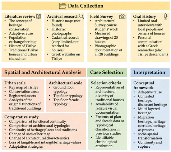
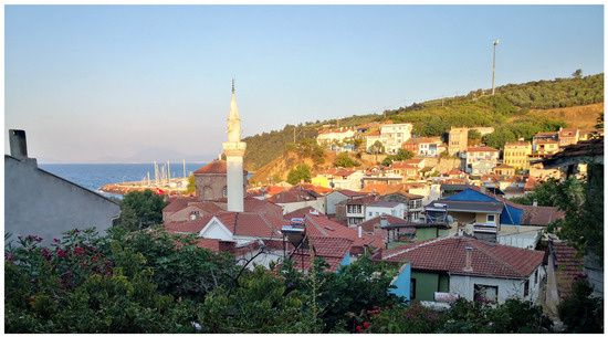
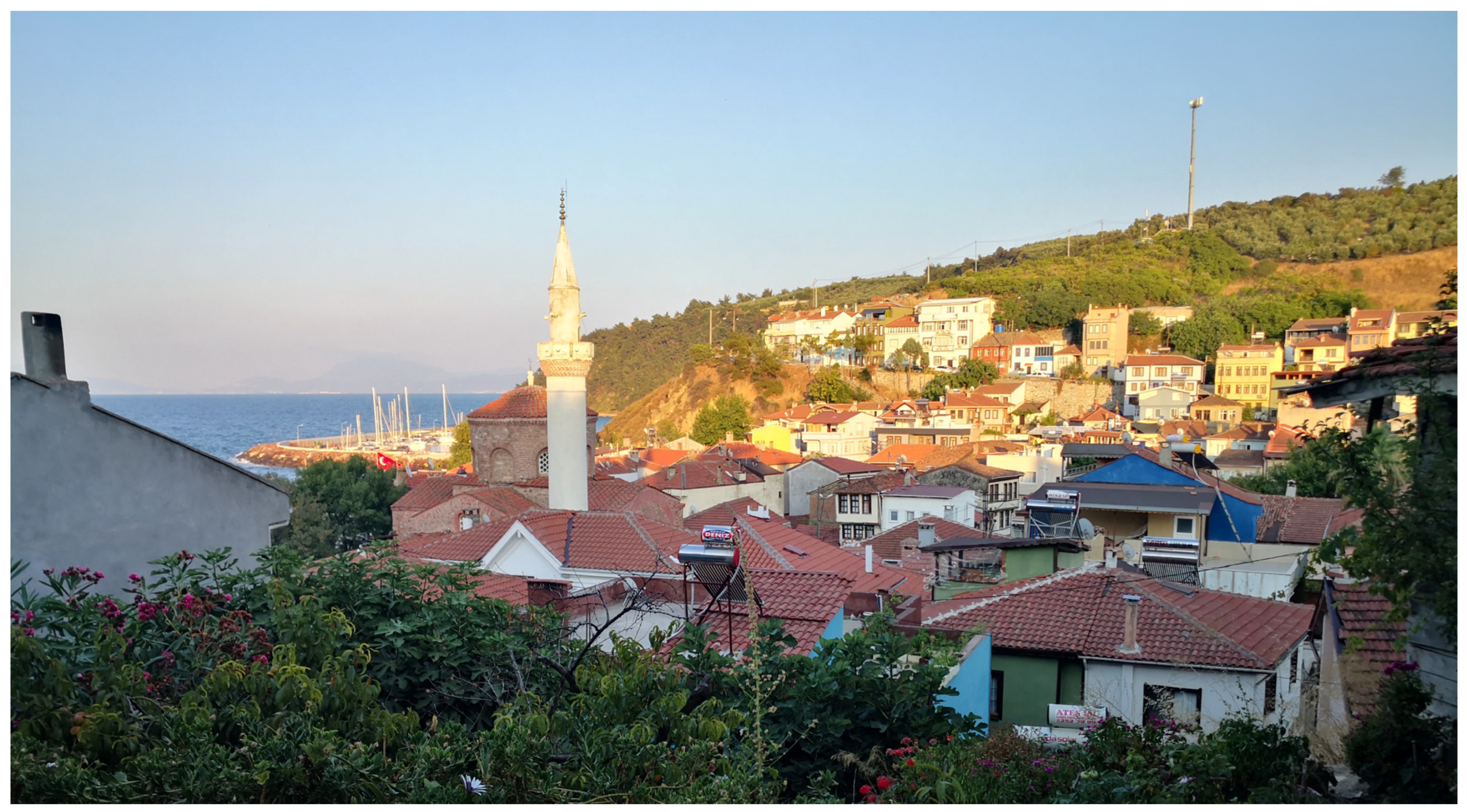
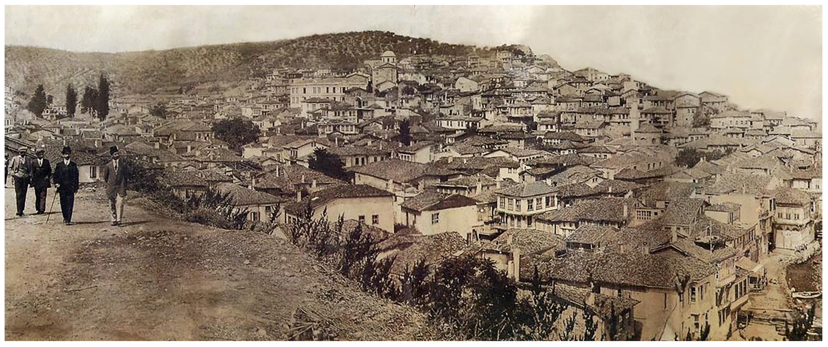
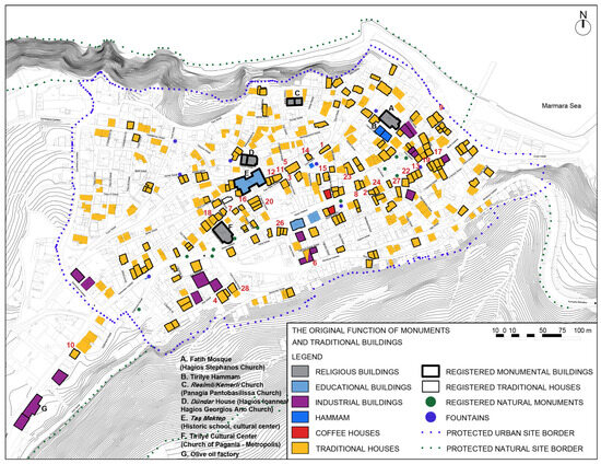
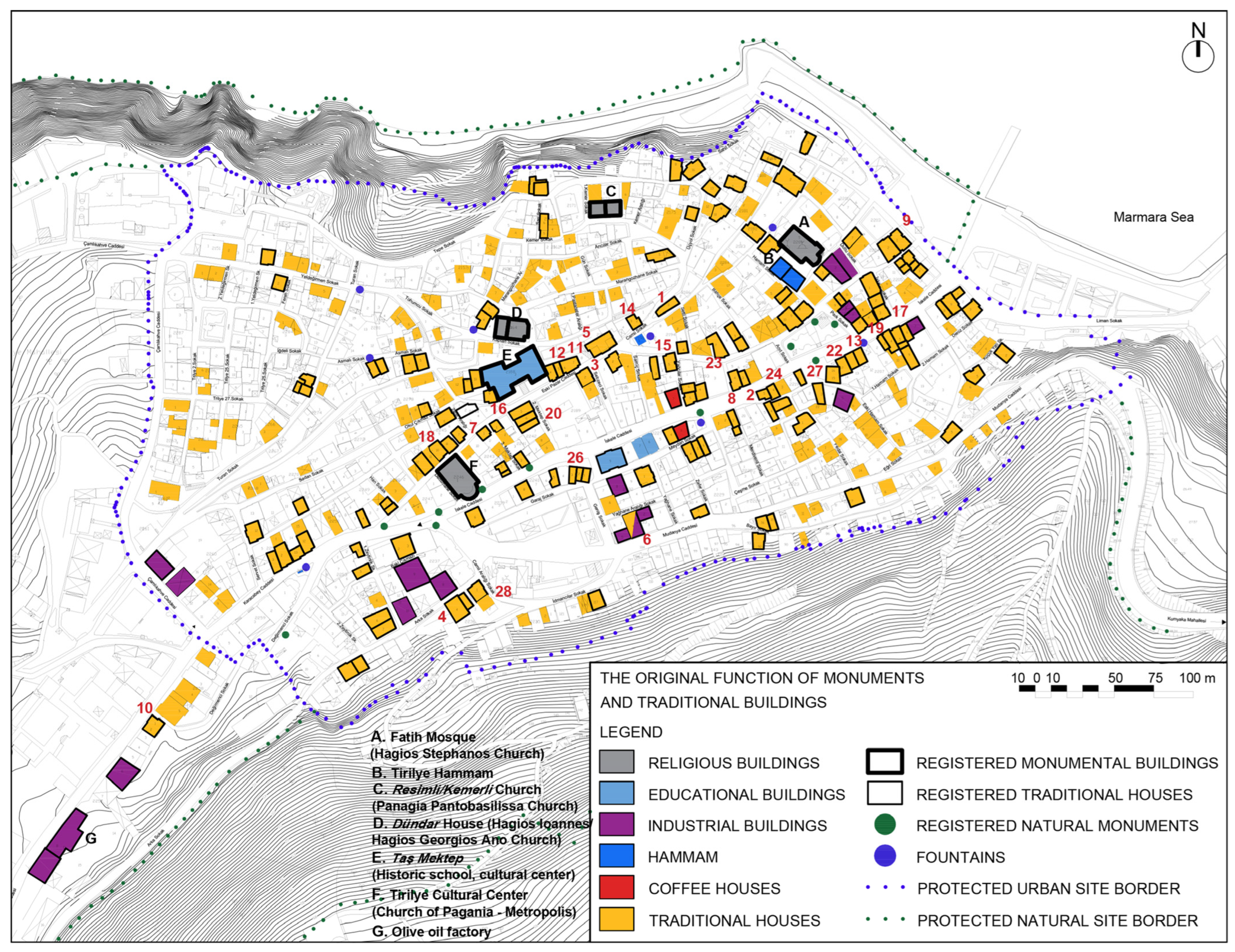
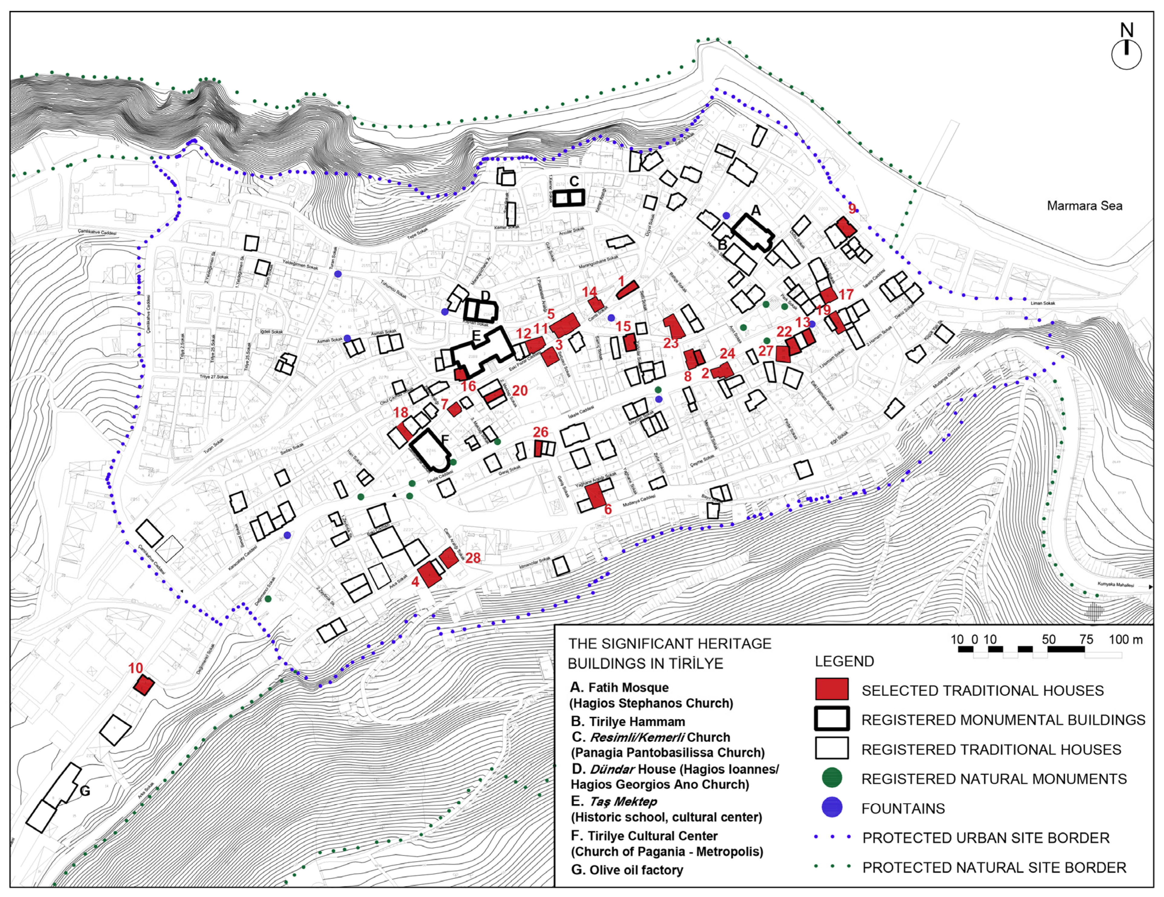
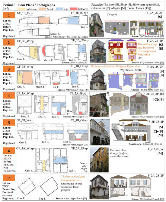
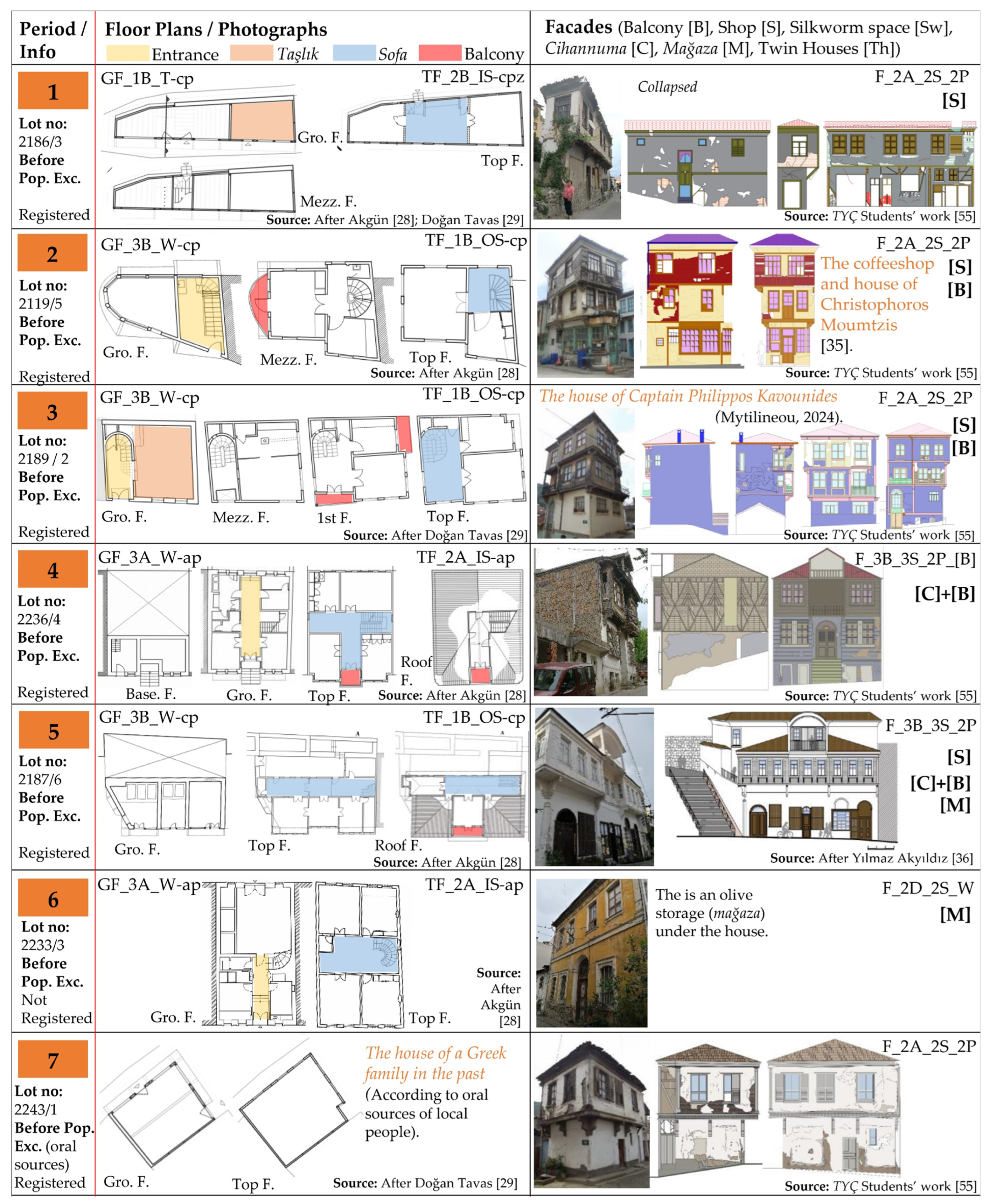
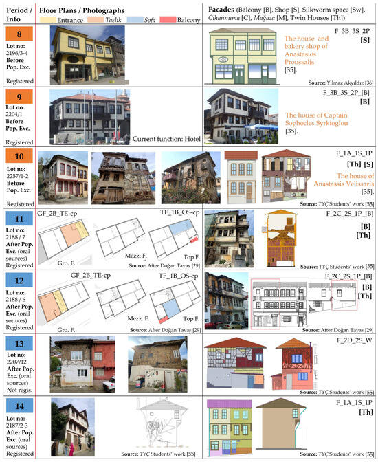
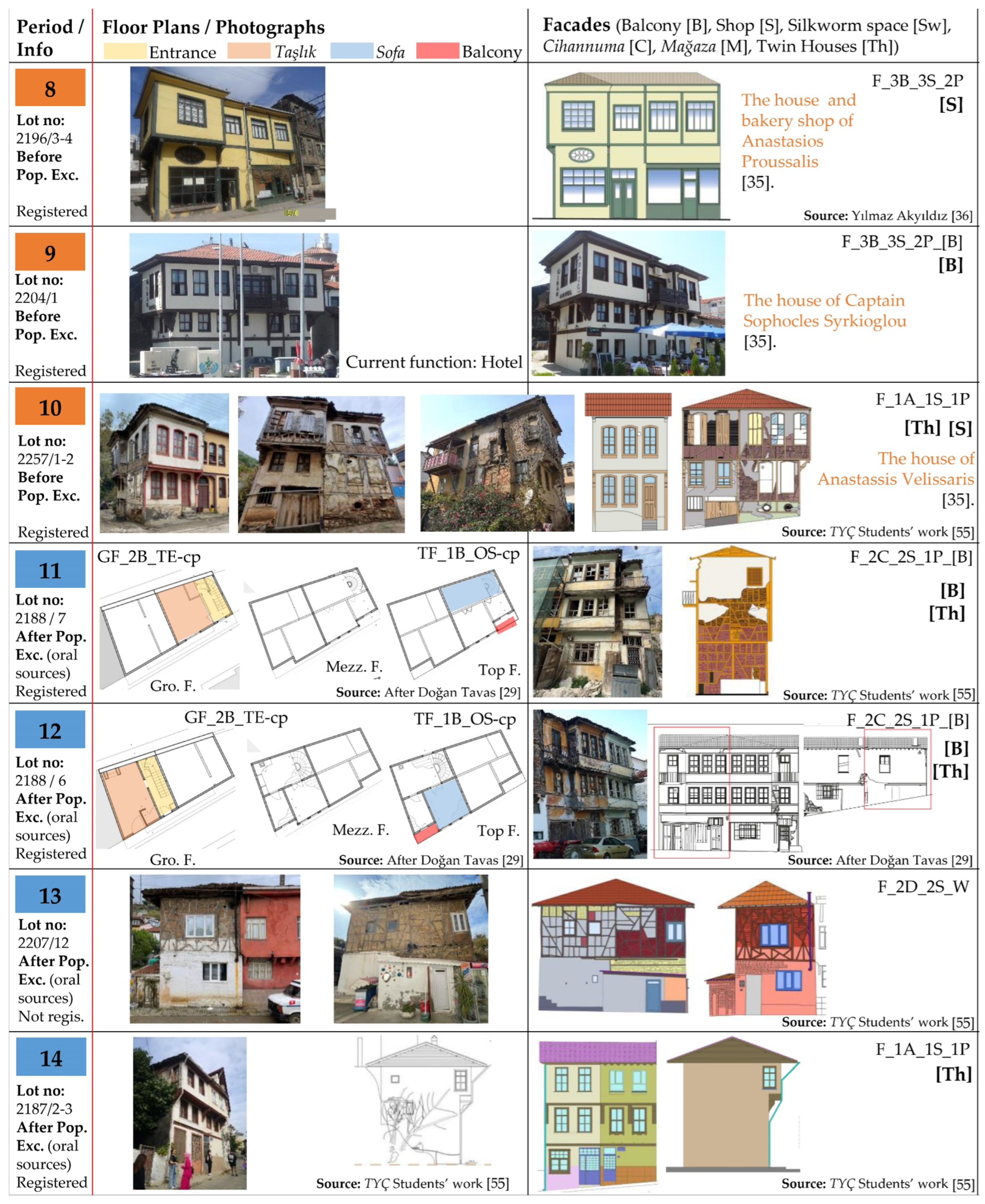
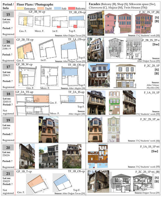
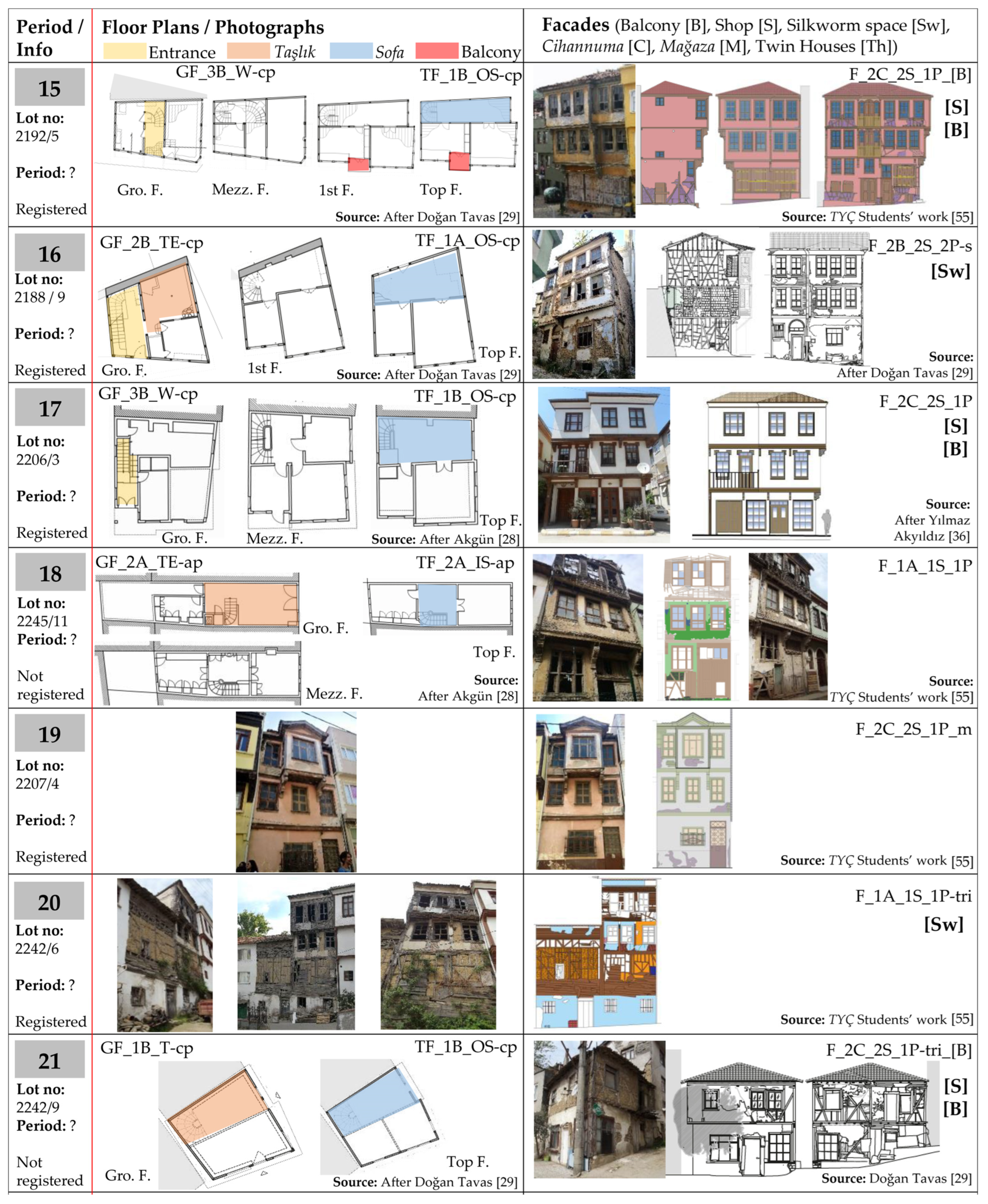
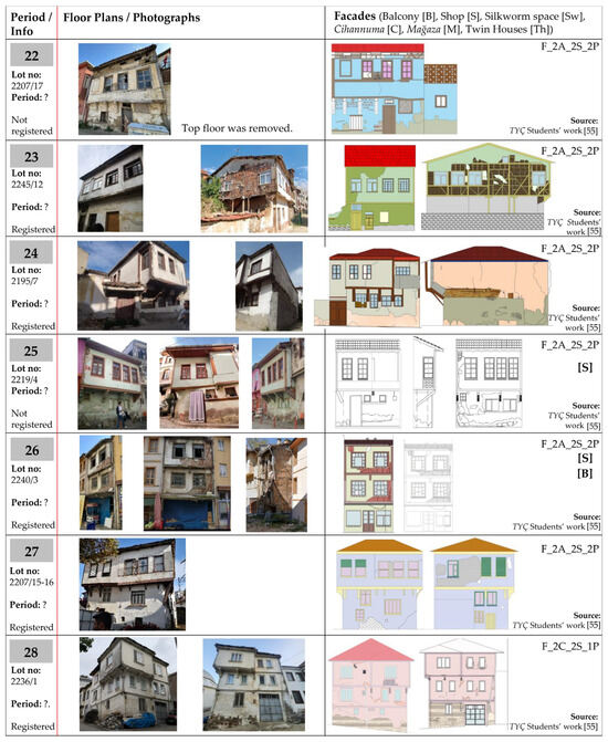
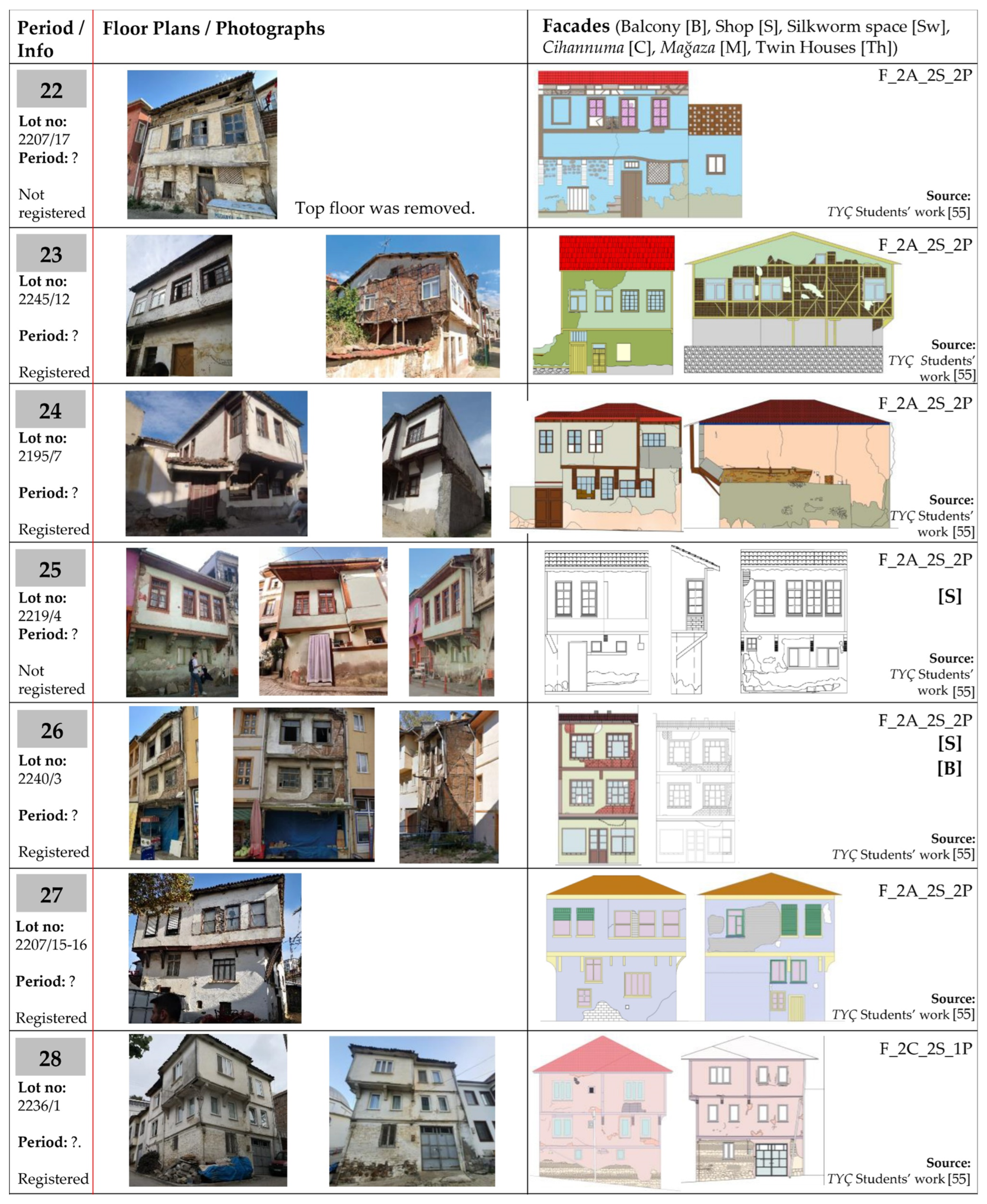

Disclaimer/Publisher’s Note: The statements, opinions and data contained in all publications are solely those of the individual author(s) and contributor(s) and not of MDPI and/or the editor(s). MDPI and/or the editor(s) disclaim responsibility for any injury to people or property resulting from any ideas, methods, instructions or products referred to in the content. |
© 2026 by the authors. Licensee MDPI, Basel, Switzerland. This article is an open access article distributed under the terms and conditions of the Creative Commons Attribution (CC BY) license.