


Abstract
Boron is a critical strategic mineral resource. Boron deposits in the Liaodong region currently supply more than 35% of China’s domestic demand. To advance exploration efforts in this area, detailed physical property measurements were carried out on various rock formations within the Yingkou–Anshan district. Utilizing integrated geophysical approaches, including gravity, magnetic, and electrical surveys, this study introduced—for the first time—the wide field electromagnetic method (WFEM) for deep exploration testing. Measured parameters included density, magnetic susceptibility, and resistivity. The electromagnetic methods proved effective in boron mineral exploration due to their pronounced response over the Lieryu Formation, which is enriched in boron minerals. We refined inversion parameters to improve the consistency between geophysical models and actual geological characteristics by correlating physical property parameters with drilled core lithology. Comprehensive analysis indicates that boron mineralization in the Houxianyu mining area is not restricted to the Lieryu Formation. Significant boron enrichment also occurs in deeper structures, including thick granite bodies, large-scale folds, and various unconformity contacts. These deep mineralized bodies share similar physical properties with known ore deposits but exhibit distinct geochemical signatures. Through integrated interpretation of gravity, magnetic, and electrical profiles—combined with geological, mineralogical, and structural data from the Houxianyu area—it is evident that ore bodies in the study area occupy structurally complex positions, influenced by regional tectonic evolution and magmatic activity. Geophysical results further reveal a notable deep extension of mineralization, indicating promising potential for deep prospecting.
1. Introduction
Boron is a vital chemical raw material with extensive applications and has been classified as a strategic or critical mineral by multiple countries. Globally, boron resources are highly concentrated, primarily distributed in Türkiye, Russia, the United States, Chile, and China. In China, boron deposits are mainly located in the northeastern and southwestern regions, with the largest reserves found in the northeast—particularly in eastern Liaoning Province, which accounts for over 35% of the country’s total boron resources [1]. Current methods for boron exploration worldwide include well logging, radiometric surveys, and petrographic analysis. France has applied electromagnetic measurements to depths of up to 1 km, though this remains insufficient for modern exploration requirements. In the Yingkou–Anshan area, boron exploration has been conducted for decades, leading to the discovery of several new ore bodies. Dedicated research on geological conditions and prospecting directions has also been carried out, providing a foundation for further exploration in this region [2]. Nevertheless, despite a relatively clear regional structural framework, studies on secondary fold structures and ore-controlling features remain inadequate, which significantly limits a comprehensive understanding of boron mineralization patterns and orebody characteristics [3]. Although the Houxianyu area has been relatively well studied, deep geological variations and orebody extensions are still poorly constrained. Additionally, the genetic relationship between Paleoproterozoic minor granite intrusions and boron mineralization remains unclear; currently, such intrusions are only tentatively regarded as prospecting indicators [4]. Moreover, the range of effective methods available for boron exploration is still limited and warrants further investigation.
Based on comprehensive geological profile measurements, regional metallogenic models, and previous mineral geophysical and geochemical survey results, four prospective target areas within the working region were selected through integrated analysis, namely Houxianyu in Yingkou, Zhugeling in Haicheng, Shengtieling in Xiuyan, and Dafangshen. These targets are all located within the Liaodong Ji’an boron metallogenic belt, where boron-bearing rock series, fold structures, and Liaoji granites serve as the principal ore-controlling factors. The region exhibits favorable geological conditions for mineralization, indicating promising exploration prospects [5]. An analysis of historical exploration data reveals that the Houxianyu area has undergone the most extensive investigation, including multiple rounds of survey, detailed examination, and exploration activities. The research level in this area is relatively advanced, with most studies suggesting significant potential for mineral discovery. Detailed studies on the boron mineralization model and orebody characteristics in Houxianyu were conducted using integrated geophysical methods such as gravity, high-precision magnetic, WFEM, and geological profiling, enabling a thorough analysis of the stratigraphy and structure of the Houxianyu boron deposit. The WFEM survey yielded notable results, offering valuable insights for guiding the boron mineralization model and exploration targeting in this region [6,7]. Research further indicates that boron mineralization in the Houxianyu area is not limited to the Lieryu Formation but also extends into deeper geological settings beneath thick granite bodies, within large-scale folds, and along various unconformable contacts, where boron enrichment is evident. These settings demonstrate favorable conditions for the formation of boron-iron ores and suggest considerable potential for deep boron resource exploration.
2. Research Foundation
2.1. Geological Background Analysis
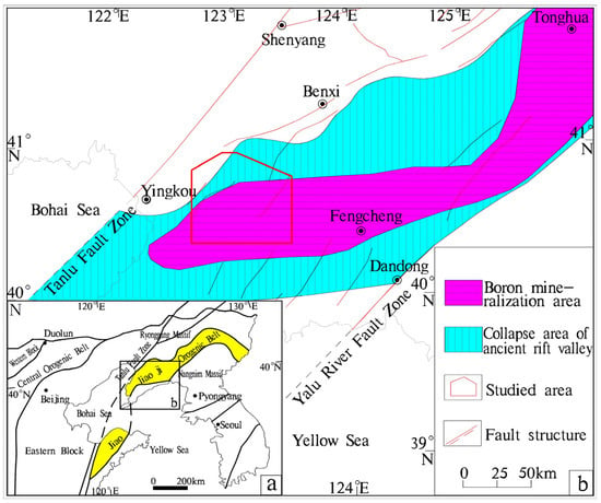
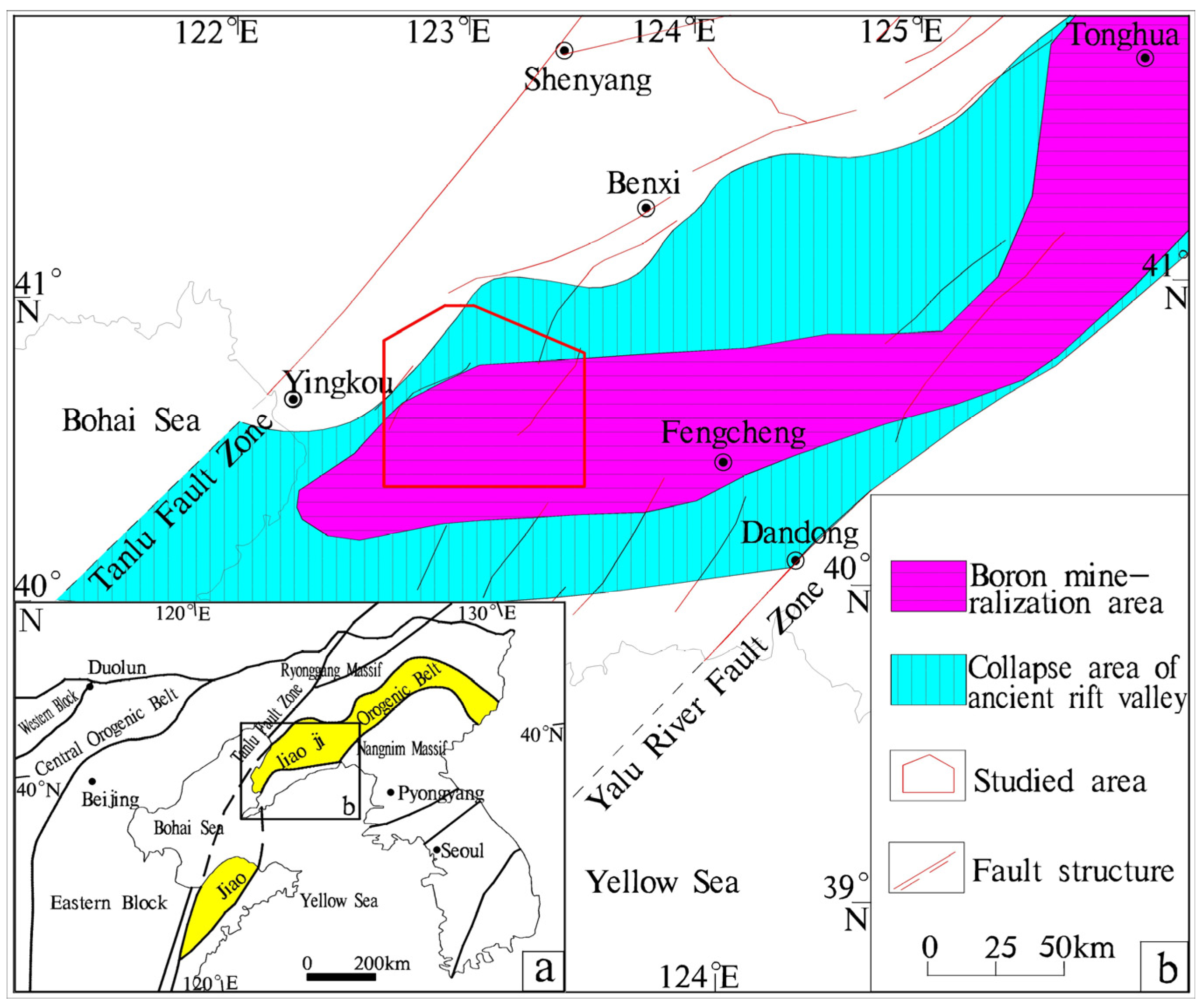
The geological structure of the research area is located in the Qaidam North China Plate, North China Craton, Liaodong Neoproterozoic-Paleozoic Depression Zone, and Liaoji Paleoproterozoic Aulacogen (Figure 1). Regionally, it lies in the western part of the Hupiyu-Hongshilazi Anticline and the western part of the Yingluo-Caohaikou Synclinorium [8,9]. From a metallogenic perspective, it is situated in the western part of the Yingkou–Kuandian Paleoproterozoic Indosinian-Yanshanian Au-Ag-Pb-Zn-B metallogenic belt [10].
Figure 1.
Distribution map of the Yingkou–Anshan boron metallogenic belt. (a) The tectonic location; (b) distribution map of the Yingkou–Anshan boron metallogenic belt.
The strata exposed in the study area are dominated by the metamorphic rock series of the Paleoproterozoic Liaohe Group, which are distributed in a nearly east–west or northwestern direction along the Hupiyu-Hongshilazi Compound Anticline and the western flanks of the Yingluo-Caohekou Compound Syncline. Lithologically, the lower part of the Liaohe Group comprises an intermediate-acid volcanic rock formation intercalated with intermediate-basic volcanic rocks, the middle part consists of a semi-argillaceous rock-argillaceous rock-carbonate rock formation, and the upper part is dominated by an argillaceous rock formation. All these formations have undergone regional metamorphism of the low amphibolite facies. Stratigraphically, the Liaohe Group is divided into the Langzishan, Lieryu, Gaojiayu, Dashiqiao, and Gaixian Formations in ascending order. The Cenozoic Quaternary System is distributed along the valleys in the area [11,12]. The regional strata are partitioned into northern and southern zones with the axis of the Yingluo-Caohekou Compound Syncline as the boundary. The Lieryu Formation displays the most significant variations [13].
Most intrusive rocks of various periods are exposed in Paleoproterozoic uplifts, generally distributed in an east–west direction. The Paleoproterozoic medium-fine-grained streaky monzogranite has isotopic ages of 1955 Ma and 2100 Ma (U-Pb dating). Most of these granites are exposed in fold cores, occurring as domes, with boron-bearing rock series surrounding them, indicating a close genetic relationship with boron mineralization. Gabbro and pyroxenite are often closely associated, occurring in groups and belts in an east–west direction, intruding different horizons of the Paleoproterozoic Liaohe Group. Most of these rock masses are small and have undergone regional metamorphism and migmatization. Diorites are the most developed rock type in the Liaohe cycle, mostly occurring as small stocks. Most stocks exhibit gneissic structure, with gneissic foliation parallel to the surrounding rocks, and are intruded by Late Variscan and Indosinian rock masses [14,15]. The Indosinian period was a peak period of intrusive activity, characterized by numerous rock masses with extensive distribution and large scale. In addition to stocks, there are also large batholiths, with individual rock masses often showing irregular shapes, controlled by Paleoproterozoic and older composite anticlines and later faults of various directions. Porphyritic monzogranite is the dominant rock type, accompanied by diorite, quartz diorite, granodiorite, medium-fine-grained monzogranite, etc. The Late Yanshanian period was the most active stage of magmatic intrusion in the Yanshanian cycle, with the Liaodong Platform Arch being one of the main distribution areas [16,17]. The first phase of Late Yanshanian magmatic intrusion was particularly intense, dominated by granites, followed by diorites, with fewer syenites and gabbros. Vein rocks in the region mainly include diorite, diorite porphyrite, granodiorite porphyry, granite porphyry, dacite, amphibolite, pegmatite, and lamprophyre veins, etc., predominantly distributed in northeast and northwest directions [18].
The rock strata in the region have undergone multiple phases of transformation by Liaohe period regional metamorphism and deformation, as well as later tectonic activities, resulting in complex fold structures and well-developed faults [19]. Regional folds include the Hupiyu-Hongshilazi Anticlinorium and the Yingluo-Caohaikou Synclinorium, with numerous secondary folds such as the Gaojiabaozi Anticline and Wuleishan Anticline [20]. Faults are well developed in the western part of the region, moderately developed in the southern part, and poorly developed in the northern and eastern parts. Based on their strike directions, faults can be divided into four groups: northeast–north–northeast, northest, north–south, and near east–west [21,22].
Paleoproterozoic metamorphic rocks are widely developed in the study region, mainly the Paleoproterozoic Liaohe Group metamorphic rocks. The types of metamorphic rocks in the region are complex. According to their mineral assemblages and fabric characteristics, the metamorphic rocks can be divided into mica schist, felsic leptynite, marble, calc-silicate rock, and metamorphic sandstone [23]. The variations in composition and texture of these lithologies lead to the differentiation of their geophysical properties, thereby offering a fundamental basis for subsequent geophysical prospecting work.
2.2. Geophysical Numerical Analysis
Analysis of existing surface sample test results shows that the Dashiqiao Formation exhibits high resistivity; the Gaixian and Gaojiayu Formations show medium-high resistivity; the Lieryu Formation leptynite has low resistivity, while other lithologies in this formation have medium-high resistivity; and the Paleoproterozoic granite displays high resistivity. These results indicate certain physical property differences between the target Lieryu Formation and other horizons. Detailed numerical statistics are presented in Table 1.
Table 1.
Physical property test results.
2.3. Target Area Selection
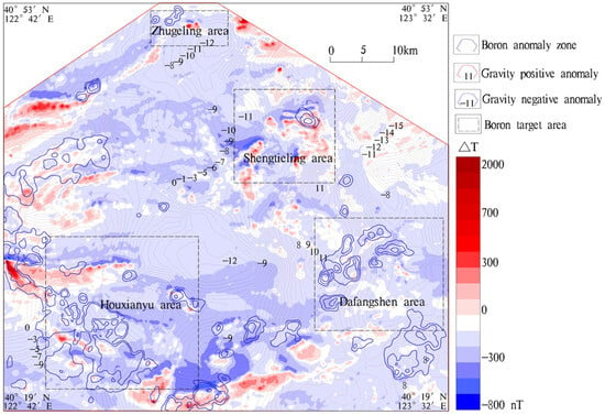
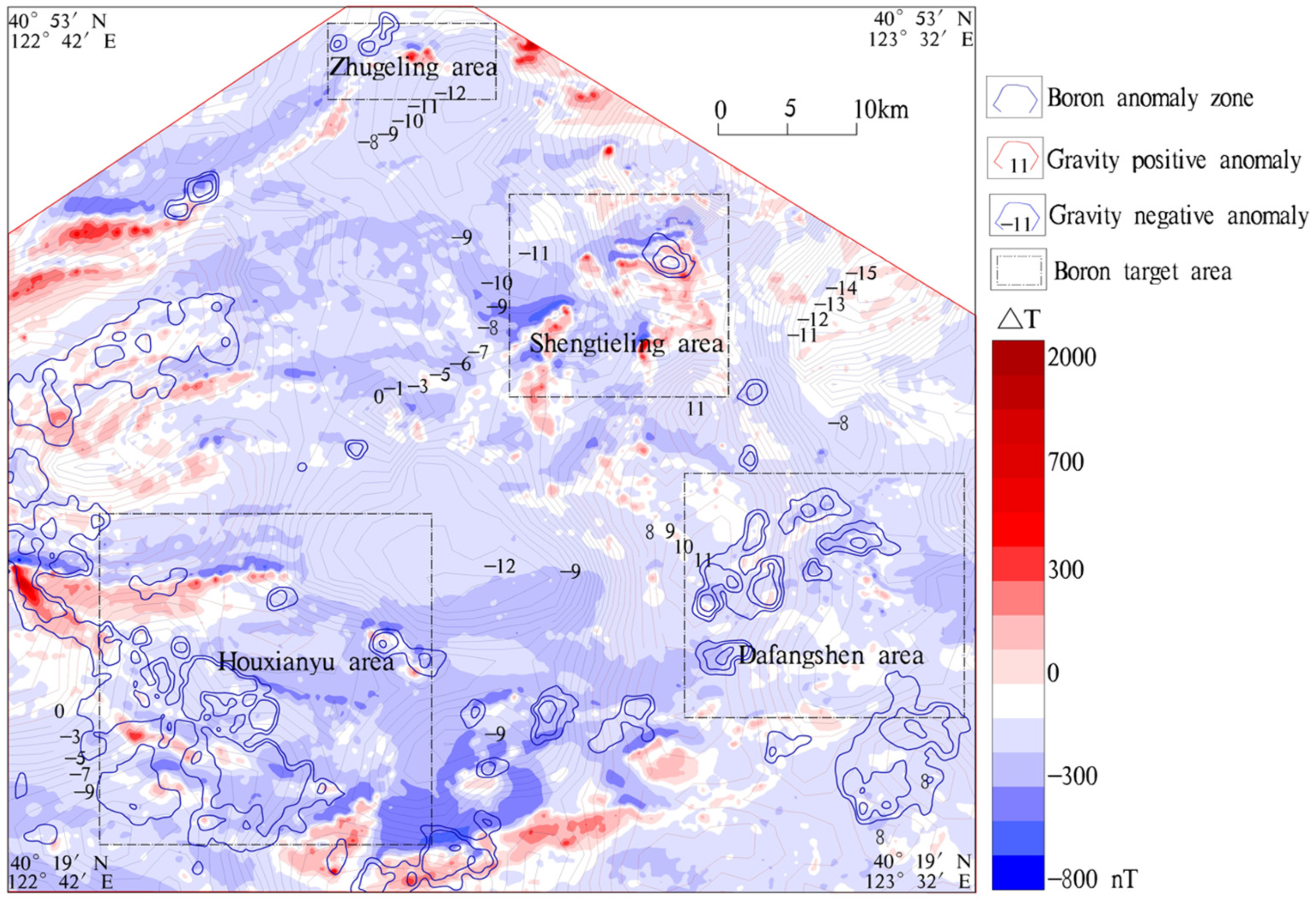
The aeromagnetic anomalies in the region are generally weak (Figure 2), with an irregular magnetic field showing an overall pattern of low in the center and high in the surrounding areas. The central low-value zone roughly coincides with the residual gravity low-value zone, and the contour map indicates that the region is dominated by negative magnetic field zones. Aeromagnetic anomalies can be roughly divided into two types: one associated with the Lieryu Formation, with a distribution range basically consistent with that of the Lieryu Formation; the other not corresponding to the known outcrop areas of the Lieryu Formation, which can be further divided into banded anomalies in the Gaixian Formation and planar anomalies in the eastern part of the region. Using 20 nT as the anomaly boundary, 102 aeromagnetic anomalies with an area greater than 0.4 km2 were delineated. It is initially believed that some aeromagnetic anomalies can provide valuable information for boron exploration, with the weak magnetic anomalies in the eastern part being comparable to those of the Houxianyu boron deposit. Sub-anomalies were delineated using 160 nT as the boundary, and the strong magnetic anomalies above 160 nT can be compared to those of boron-iron deposits.
Figure 2.
Pre-selection map of Houxianyu target area.
The residual gravity anomalies in the region generally exhibit a “high-low-high-low” trend from west to east. The high-value zones generally correspond to the distribution areas of the Liaohe Group, and the intensity of residual gravity anomalies may be related to the thickness of the Liaohe Group. It is initially inferred that the residual gravity low-value zones are associated with Mesozoic granite intrusions or concealed rock masses.
Boron element anomalies were delineated based on the results of the new round of 1:200,000 stream sediment surveys in the province, generally showing a pattern of planar anomalies in the southwest and local anomalies in other parts. Most anomalies coincide with the known outcrop areas of the Lieryu Formation, indicating the distribution range of the Lieryu Formation. The boron anomalies distributed in the outcrop areas of the Gaixian Formation in the northwest have unclear geological significance.
Based on the characteristics of typical deposits in the region and comprehensive research results, the target area selection principles are as follows: areas with known boron ore belts, thick boron-bearing rock series, significant boron element anomalies (in terms of intensity and scale), and aeromagnetic anomalies (in terms of scale). The exposed Paleoproterozoic streaky granite in the region, together with the boron-bearing rock series, forms positive structures consisting of a series of dome structures or short-axis anticlines, with the Paleoproterozoic monzogranite as the core and the boron-bearing rock series as the rim.
Target areas of the same type were graded and ranked based on the scale of the boron ore belt, the scale of the boron-bearing rock series, the intensity and scale of boron element anomalies, and the scale of aeromagnetic anomalies. Combined with previous geological exploration data and integrated geophysical-geochemical analysis results, the spatial distribution characteristics of Paleoproterozoic streaky granite complexes and boron-bearing rock series were predicted, and metallogenic conditions and regional boron metallogenic regularity were summarized. Based on the study of typical deposits, metallogenic prediction was conducted, and four boron prospecting target areas were selected. A comprehensive comparison indicates that the Houxianyu area has the most favorable metallogenic background and the highest potential for hosting large-scale boron deposits; thus, it was selected for further detailed research.
3. Research Content
3.1. Determination of Work Methods
Through measurement experiments, the WFEM was determined to have a transmitting end AB distance of 1 km, the measured pole distance is 50 m, and the transmitting and receiving distances are 10–15 km, all of which meet the requirements of signal acquisition, can suppress interference signals, and meet the requirements of depth. The electromagnetic data collected in the field is processed and inverted into maps using the “Integrated System for Comprehensive Processing and Interpretation of Geophysical Data” for WFEM profiles. The inversion model is determined jointly based on gravity, magnetic, and electric data, with more than 5 iterations.
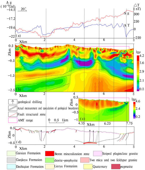
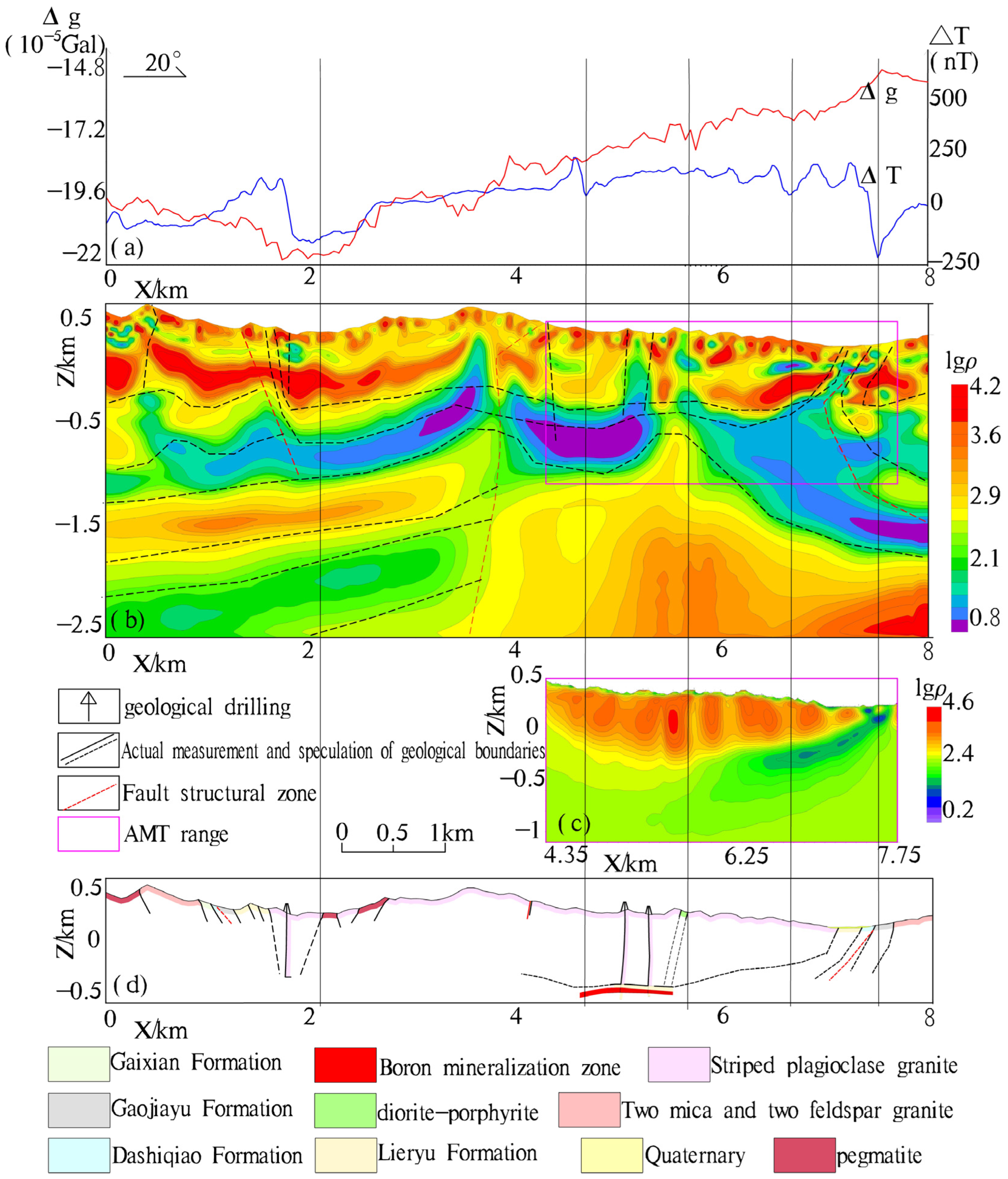
In the Houxianyu area, a profile Line (Figure 3) was selected for comparative analysis of multiple geophysical methods based on the presence of known thick boron mineralization zones, outcrops of Paleoproterozoic streaky granite, geochemical anomalies, aeromagnetic anomalies, and comprehensive stratum coverage. The results of gravity, magnetic, WFEM, and AMT surveys show that the profile can be divided into two segments with the 4 km mark as the boundary. The first segment exhibits relatively low gravity and magnetic values, and the electromagnetic inversion results reveal four electrical horizons. The second segment shows relatively high gravity and magnetic values, and the electromagnetic inversion results reveal three electrical horizons. The AMT profile is consistent with the WFEM profile results in the shallow part but has a smaller exploration depth, indicating the advantage of the WFEM in terms of exploration depth [24,25]. Combined with physical property results and geological data, it is inferred that the shallow high resistivity is related to streaky granite, and the low resistivity is associated with the Lieryu Formation. The granite intrudes from the basement to the shallow part, generally showing a mushroom shape. Analysis of the electrical and magnetic anomaly patterns indicates that the segment is characterized by well-developed faults and fold structures, with the possible presence of one or more deep and large faults, and the potential repetition of the Liaohe Group. Geological understanding of the region also confirms that the rock strata here have undergone multiple phases of transformation by Liaohe-period regional metamorphism and deformation, as well as later tectonic activities, resulting in complex fold structures and well-developed faults. The comprehensive analysis of the profile also supports this understanding. The inference of fault zones is basically consistent with geological engineering observations.
Figure 3.
Comparison of results from multiple methods. (a) Gravity magnetic profile; (b) WFEM profile; (c) AMT profile; (d) geological profile.
Comprehensive analysis of the line indicates that the thickness of the streaky granite caprock is approximately 0.3 km–1 km, with the Lieryu Formation as the footwall. Due to fold structures in the southern part, the Liaohe Group is repeated. The granite intrudes from the basement to the shallow part in the eastern part of the survey area, generally showing a mushroom shape, with well-developed fault structures. Boron orebodies are hosted in the gentle fold flanks of the Houxianyu Syncline and Liujia Tai Anticline, and the northern flank of the gentle Zhaojiagou Anticline is a favorable metallogenic location.
3.2. Engineering Layout
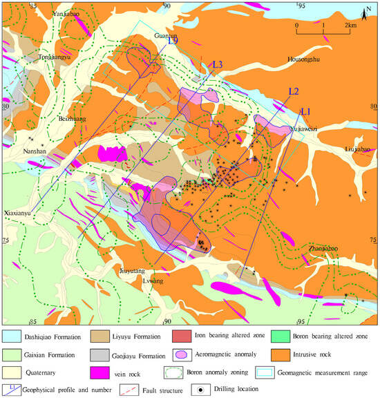
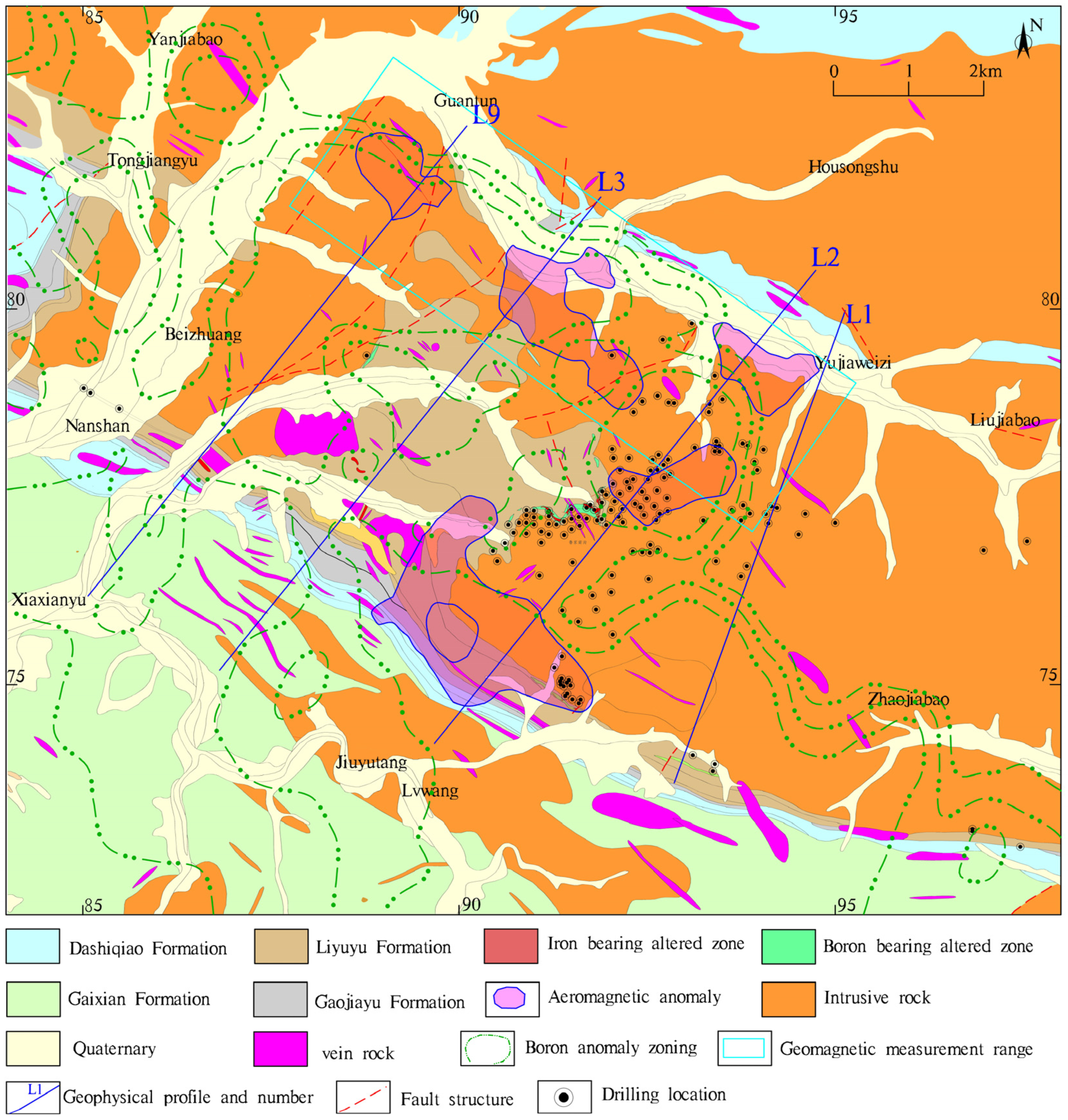
No matter which geophysical method is heavy—magnetic, or electrical—it has a significant response to changes in geological structures. The division of strata, magmatic rocks, and structural frameworks by the WFEM is basically consistent with the geologically measured profiles and AMT results measured at depths of less than one kilometer. The deep speculations also conform to geological laws. By combining the comprehensive analysis of gravity, magnetism, and electricity on typical profiles with a geological understanding of the entire area, the WFEM has been used to identify the distribution of strata, magmatic rocks, and structural frameworks in the shallow- to medium-deep working areas. This has provided important geophysical evidence for analyzing and predicting the distributable space of boron ore belts and summarizing the laws of boron ore formation. On the basis of preliminary target area selection and verification, the prospecting target areas were further optimized through geological surveys, integrated geological-geophysical-geochemical profile measurements, and magnetic surveys. Through comprehensive research on boron metallogenic information, favorable metallogenic locations were selected, and prospecting projects were used to verify the metallogenic potential of the target areas (Figure 4). The main engineering layout includes the completion of comprehensive gravity-magnetic-electrical profiles in the Houxianyu study area, the deployment of drilling holes in areas with favorable anomalies to clarify the distribution of middle-deep strata, magmatic rocks, and structural frameworks, and the analysis and prediction of the potential distribution space of boron ore belts, providing an important geophysical basis for subsequent geological exploration work. Target areas with significant prospecting results from verification work will be prioritized for resource expansion, with orebodies controlled to initially understand their spatial distribution characteristics, ore quality, and deposit scale, laying the foundation for further geological exploration.
Figure 4.
Engineering layout of Houxianyu region.
4. Research Findings
4.1. Magnetic Exploration Results
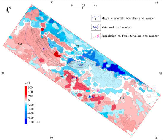
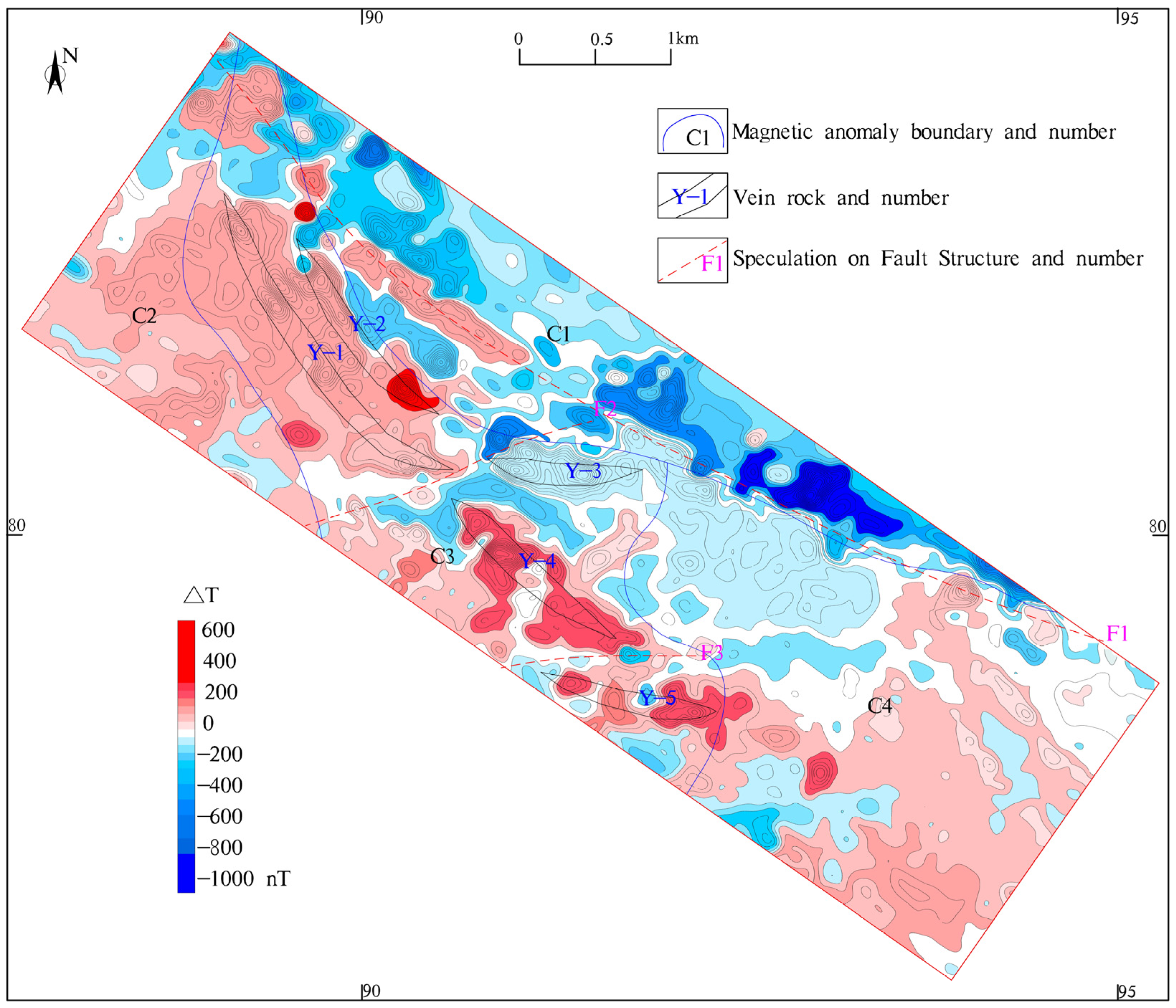
High-precision ground magnetic surveys were conducted at locations where aeromagnetic anomalies coincide with boron element anomalies. Measurements using a GSM-19T magnetometer produced in Canada with an accuracy of 0.01 nT. Anomalous areas were delineated and numbered, and the magnetic survey results were interpreted in combination with geological understanding. The C1 low magnetic anomaly corresponds mainly to the first member of the Dashiqiao Formation and Jurassic intermediate-acid magmatic rock areas, with local anomaly values (ΔT −500–0 nT). The magnetic anomalies are inferred to be caused by leptynite and granite within the strata. The gentle C2 and C4 magnetic anomalies correspond to migmatite areas, with local anomaly values (ΔT 0–300 nT), inferred to be caused by migmatitic granite. The alternating high and low C3 magnetic anomaly corresponds mainly to the Lieryu Formation, with local anomaly values (ΔT −400–600 nT). The sharply varying high and low magnetic anomalies are inferred to be caused by intermediate-basic vein rocks with high ferrimagnetic mineral content within the strata (Figure 5).
Figure 5.
Magnetic scanning results of Houxianyu region.
Based on the magnetic field characteristics, five intermediate-basic vein rocks were delineated within the C3 magnetic anomaly range. The inferred characteristics of the vein rocks are presented in Table 2.
Table 2.
List of inferred vein rock features.
4.2. Comprehensive Interpretation of Gravity, Magnetic, Electrical, and Geological Data
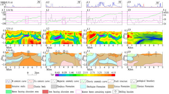
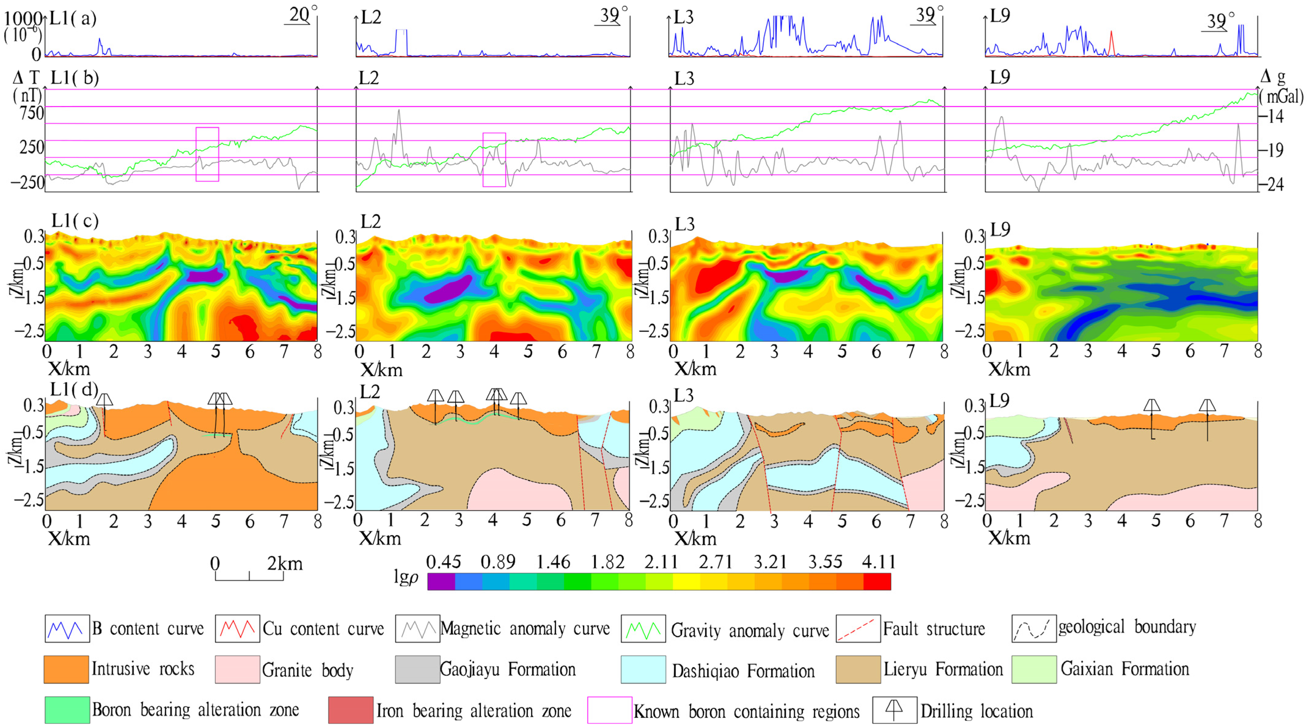
Comprehensive measurements were conducted using gravity, magnetic methods, WFEMs, etc. (Figure 6). The gravity was measured using a CG-5 gravimeter with an accuracy of 1 μ Gal. The frequency range of WFEM is 0.5–8192 Hz. The mean square error of quality inspection is less than 3%. Joint gravity-magnetic-electrical inversion analysis was conducted on the profiles, with inversion parameters constrained by core data from verification drilling. Continuous fitting of inversion results shows that the four profiles generally have similar segmentation patterns and electrical horizons. Magnetic peaks are basically located in the outcrop areas of the Lieryu Formation, with positive magnetic anomalies positively correlated with the Lieryu Formation and negative anomalies mostly coinciding with inferred fault structures. The gravity field generally shows a low east–west and high center pattern, consistent with changes in stratum lithology and physical property statistics. The WFEM inversion profile can be roughly divided into three parts with the 5 km and 14 km marks as boundaries. The first part is dominated by medium-high apparent resistivity, consistent with the stratum and lithology division by magnetic and gravity methods. Combined with magnetic and gravity results, it is inferred that this part is characterized by well-developed rock masses. The second part shows irregular layered apparent resistivity, generally presenting a low-high-low-high-low-high distribution pattern, including strata such as the Gaixian, Dashiqiao, and Lieryu Formations. A thick medium-high resistivity layer exists in the deep part, with an inferred thickness of nearly 1 km. Based on geological and physical property data, it is inferred to be Paleoproterozoic granite. The third part generally has high resistivity, inferred to be dominated by Paleoproterozoic granite with a certain scale.
Figure 6.
Comprehensive study map of the Lines L1, L2, L3 and L9 in the Houxianyu region. (a) Curve of B and Cu content; (b) curve of magnetic and gravity anomaly; (c) WFEM inversion profile; (d) geological interpretation map.
Comprehensive research on the interpretation results of four geophysical-geochemical profiles and geological understanding summarizes the regional anomaly characteristics. The southern part of the profile is characterized by normal sequence strata and well-developed fold structures, resulting in the repetition of the Liaohe Group. The northern part of the profile consists of inverted strata, with possible horizontal layered Lieryu Formation within the streaky granite, and the inferred footwall is the Lieryu Formation. Inferences from Lines L1 and L2 suggest that the shallow, streaky granite may originate from the deep part. The horizontal distribution pattern of high and low resistivity in the shallow part of Lines L2 and L3 indicates the possible presence of nappe structures in the region. Comprehensive inversion combined with geological understanding reveals that the boron-bearing rock series in the western part of the Houxianyu boron deposit is significantly thicker than that in the eastern part, with well-developed fold structures, presenting favorable metallogenic conditions. The core analysis of geological boreholes also confirms this. Geochemical B anomalies are all attributed to the Lieryu Formation. Additionally, low-resistivity anomalies are often detected in the deep part of B anomaly peaks, and there is a certain correlation between B anomalies and Cu anomalies. The gravity curves of the Liaohe Group are mostly located in low-value areas and show stable characteristics. The gravity curves of granite areas are significantly elevated. In areas with well-developed structures, the magnetic curves fluctuate sharply, and the overall magnetic values of the Liaohe Group are lower than those of granite-covered areas.
Comprehensive analysis of gravity-magnetic-electrical profiles indicates that all geophysical methods (gravity, magnetic, and electrical) show obvious responses to changes in stratum structures. In particular, the WFEM achieves excellent consistency with geologically measured profiles in the division of strata, magmatic rocks, and structural frameworks, and the deep inferences are consistent with geological laws. Comprehensive analysis of typical profiles combined with regional geological understanding demonstrates that the WFEM provides an important geophysical basis for identifying the distribution of strata, magmatic rocks, and structural frameworks in the shallow to middle-deep parts of the study area, analyzing and predicting the potential distribution space of boron ore belts, and summarizing boron metallogenic regularity, thus offering significant support for subsequent geological exploration and research work.
4.3. Deposit Genesis and Metallogenic Indicators
- (1)
- Orebody Characteristics
The Houxianyu boron ore belt is located in the lower part of the Lieryu Formation of the Liaohe Group. The boron ore belt extends east-west, from Beitaigou in the west to Xishidonggou in the east. The local ore belt between Beitaigou and Houxianyu has been eroded. The intrusive rocks are widely distributed in the area, with an exposed area of 171.64 km2, accounting for approximately 51.90% of the working area (Table 3). According to their invasion periods, there are Paleoproterozoic and Late Jurassic, while the rest are rock veins. The rock types include basic rock and acidic rock, with acidic rock being the main type. The intrusive rocks of the Paleoproterozoic include medium-fine-grained biotite diorite granite, striated medium-fine-grained granite complex, granite pegmatite, plagioclase amphibolite, etc. Among them, the striated granite complex has the widest distribution area and is closely related to boron ore.
Table 3.
Characteristics of intrusive rocks in Houxianyu Boron Mine.
The Houxianyu-Xishidong Gou boron ore belt has a total length of 2.8 km and a thickness ranging from 12 m to 164 m (average 60 m). East of Xishidong Gou, the boron-bearing altered rock belt shows a narrowing trend and increasing burial depth. The ore minerals are dominated by szaibelyite (including tabular szaibelyite, columnar szaibelyite, and microfibrous szaibelyite) and suanite, with a small amount of ludwigite. The gangue minerals mainly consist of forsterite, serpentine, phlogopite, and tremolite. The ore textures and structures are primarily tabular-columnar metamorphic crystalline texture, fibrous metamorphic crystalline texture, metasomatic relict texture, metasomatic pseudomorphous texture, and interpenetration texture. According to the collected results of previous rock and ore assemblage analyses, the average chemical composition of the suanite-szaibelyite ore is as follows: B2O3 14.44%, MgO 42.75%, SiO2 23.00%, CaO 1.28%, Fe2O3 2.26%, Al2O3 0.69%. The boron-bearing altered rock belt is generally high in the west and low in the east, with a slight eastward plunge. Affected by folding and regional metamorphism, the boron-bearing altered rock belt shows a gentle wavy shape along the strike. Orebodies are hosted in serpentinitized forsterite within the boron-bearing altered rock belt, mostly covered by Paleoproterozoic granite at the surface, resulting in most orebodies being concealed. The distance between boron orebodies and the basement of Paleoproterozoic granite is generally 10 m–60 m, and there is a positive correlation between the thickness of orebodies and the boron-bearing altered rock belt [26,27]. The hanging wall of the boron-bearing altered rock belt is amphibole biotite plagioclase leptynite, and the footwall is mostly biotite leptynite intercalated with tourmaline leptynite. The boron-bearing altered rock belt is in conformable contact with the country rocks, the surrounding rocks [28]. The boron-bearing altered rock belt undergoes intense alteration and exhibits obvious symmetrical zoning characteristics: the central part is serpentinized forsterite and serpentinite belt, followed by phlogopite tremolite belt and tourmaline rock belt from the center outward, showing symmetry with the forsterite and serpentinite belt as the center. The phlogopite tremolite belt and a tourmaline rock belt are important division markers between the boron-bearing altered rock belt and the surrounding rocks [29].
To date, dozens of boron orebodies have been discovered, occurring as lenticular and stratoid shapes, with branching, merging, and local thickening phenomena along the strike and dip, showing significant swelling and contraction variations [30]. Orebodies exhibit obvious swelling, contraction, and pinch-out-reappearance characteristics along the strike and dip within the boron-bearing altered rock belt. Along the dip direction, the Houxianyu boron orebody pinches out southward and reappears in the Lujiagou boron deposit after a certain distance. Along the strike direction, the Houxianyu boron orebody pinches out eastward and reappears in the Chagou and Erdaogou boron deposits after a certain distance. Three-dimensional modeling of the boron-bearing altered rock belt and orebodies reveals that the boron-bearing altered rock belt is basically distributed along the Houxianyu Anticline and Liujia Tai Syncline, but boron orebodies are only found in the syncline core and its vicinity. This phenomenon may be due to the drag space formed in this structural position being conducive to orebody emplacement or the thick boron-bearing rock series in this structural position itself.
After the boron-bearing altered rock belt in the target area pinches out due to erosion west of the Houxianyu boron deposit, it reappears near Beitaigou. Prospecting projects have confirmed an extension of 100 m and a vertical thickness of 33.52 m, with main lithologies including serpentinitized forsterite, serpentinitized marble, and phlogopite tremolite. Although no boron orebodies have been discovered, the westward extension of the boron-bearing altered rock belt provides greater prospecting space for subsequent boron exploration. The Beitaigou boron-bearing altered rock belt is adjacent to the Houxianyu boron ore belt, located on both sides of the Shijiagou-Xifangshen short-axis anticline, with geological and structural characteristics basically consistent with the Houxianyu boron deposit. Large areas of Paleoproterozoic streaky granite complex are exposed at the surface. Based on the inversion results of the L9 geological-geophysical-geochemical comprehensive profile, it is inferred that a thick boron-bearing rock series exists in the deep part, showing significant prospecting potential.
- (2)
- Deposit Genesis
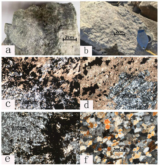
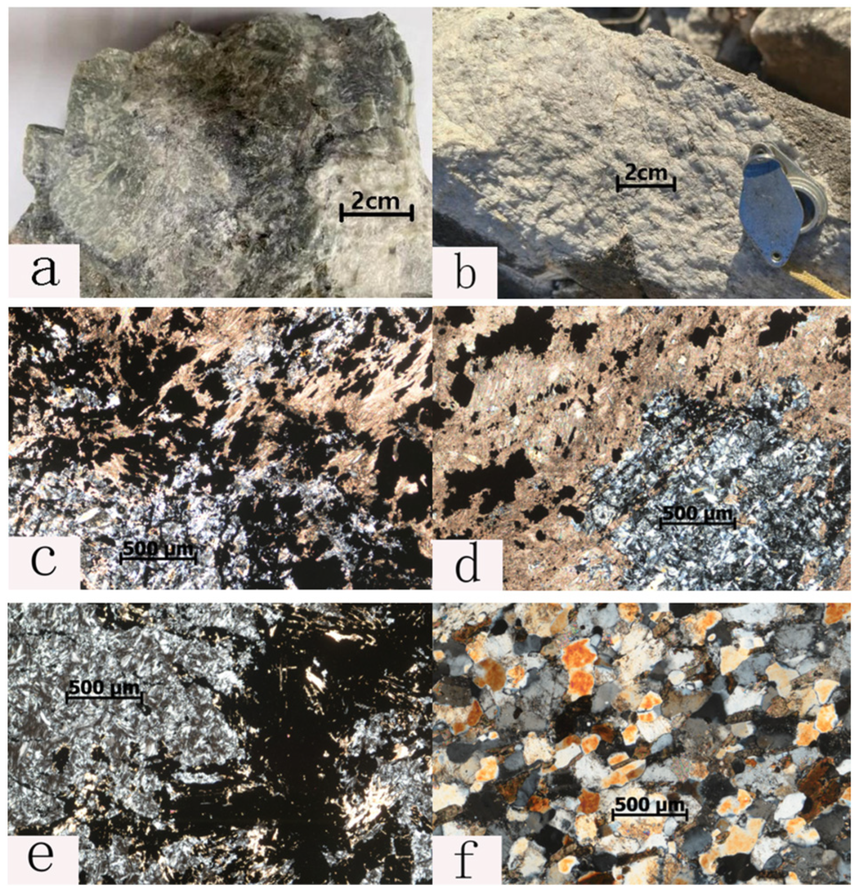
Based on a large number of rock analysis data and petrochemical analysis from scientific research projects (Table 4, Figure 7), most leptynites and leptites plot in the marl, spilite-keratophyre, and claystone areas, some in the potassium-rich intermediate-acid tuff, acid tuff, and andesitic tuff areas, and a few in the basalt area [31]. This clearly indicates that the boron-bearing horizon, the Lieryu Formation, is a set of subaqueous volcanic and argillaceous rock formations [32]. Long-term volcanic activity continuously brought a large amount of boron material from the deep crust. This boron was mainly adsorbed by volcanic and clay materials in the form of boron ions, serving as the material source for the subsequent formation of boron deposits.
Table 4.
Rock and mineral composition of Houxianyu boron mining area (partial).
Figure 7.
Field and microscopic photographs of the main rock types in the Houxianyu Region. (a) White boron (hydrated calcium borate) magnesium olivine rock; (b) magnesite marble; (c) magnetic boron magnesium serpentinite; (d) magnetic serpentinite boron magnesium rock; (e) boron magnesium magnetite serpentinite; (f) black cloud plagioclase granulite.
Magnesium in magnesian carbonate rocks provides the essential Mg for the formation of borate and other altered minerals [33]. During the Late Paleoproterozoic, under amphibolite facies regional metamorphism and granitization, SiO2, Al, K, Na, and trace elements (e.g., S, P, Fe) in altered minerals were derived from the original rocks of the Lieryu Formation [34,35]. The volcanic-argillaceous rock formation in the Lieryu Formation is rich in amorphous silica, which became the source of silicic acid (H4SiO4) in metamorphic hydrothermal fluids during amphibolite facies regional metamorphism and granitization. Metamorphic hydrothermal fluids also dissolved B, K, Na, Al, and trace elements such as P, S, Fe, and other metals from the surrounding rocks. When these hydrothermal fluids entered magnesian carbonate rocks, their properties changed to strongly alkaline, causing orthosilicic acid to dissociate. The dissociated orthosilicic acid-bearing hydrothermal fluids reacted with magnesian carbonate to first form a large amount of forsterite. The formed forsterite was then successively transformed into phlogopite and tremolite under the action of K, Ca, Al, and S-bearing hydrothermal fluids and a large amount of szaibelyite and suanite under the action of boric acid-bearing hydrothermal fluids. After a long geological period, under multiple phases of metamorphism and deformation, the ore-forming materials were reactivated and migrated, eventually enriching to form orebodies, mostly occurring as stratoid and lenticular shapes [36,37].
In summary, the boron deposits in the region are of volcanic sedimentary-metamorphic reworking type.
- (3)
- Mineralization indicators
The boron iron deposits in the Houxianyu area are mostly distributed in the lower part of the Liaohe Group in the Paleoproterozoic era, and occur in the serpentinite magnesioolivine magnesious marble interbedded by the biotite granulite in the lower part of the Liaohe Formation, which is controlled by the stratigraphy of the boron bearing rock series. The scale of boron ore bodies is positively correlated with the scale of magnesian marble, that is, the larger the scale of magnesian marble, the more favorable it is for boron mineralization [38]. And it is closely related to the Paleoproterozoic diorite, and the surface is mostly covered by Paleoproterozoic granite, so most of the ore bodies in the area are concealed. In terms of spatial distribution, the granulite is in direct contact with the Paleoproterozoic diorite, and the boron ore body is generally located between 10 and 60 m from the Paleoproterozoic granite floor [39]. Controlled by deformation structures, in terms of structural morphology and spatial distribution, it is centered around early Proterozoic diorite and bordered by boron-bearing rock series, collectively forming a series of dome-shaped structures or short-axis-shaped anticlines. The ore bodies of boron deposits mainly occur in the collapsed parts of folds, namely the wing parts of wide and gentle folds or the core parts of tightly closed folds.
Structural features in the study area are mainly concentrated in the Paleoproterozoic Liaohe Group metamorphic rock series and Paleoproterozoic streaky granite complexes. Based on their deformation mechanisms, structural styles, and assemblage characteristics, they are divided into three deformation phases: the first phase of deformation occurred in the pre-orogenic period, under the shear sliding mechanism, bedding detachment and layered shear occurred, forming bedding solid-state flow structural assemblages and regional schistosity (S1), etc. The second phase of deformation transformed into near north-south compressive contraction, dominated by brittle-ductile deformation, forming near east–west composite folds. The third phase of deformation was near east–west compression, with a shallow level, dominated by brittle deformation, forming gentle folds [40].
This work updated the geological boundaries of the Liaohe Group formations, streaky granite complexes, and other geological bodies, and divided the lithologies within the strata. Furthermore, the distribution of faults and fold structures in the study area was clarified. The impact of three regional deformation phases on the geological bodies in the study area was comprehensively analyzed, and prospecting indicators were summarized. Areas with thick boron-bearing rock series, where magnesian rocks are distributed, can be used as key survey areas. The main rock types are magnesian marble, basalt, and forsterite. Borate deposits are generally produced near Paleoproterozoic streaky monzogranite, so Paleoproterozoic streaky monzogranite can also be used as an evaluation indicator. Borate-mineralized magnesian rocks have obvious mineralization alteration and hydrothermal metasomatism and filling phenomena, mainly including serpentinitization, phlogopitization, and actinolite, tremolitization, and brucitization alterations. Mineralized rocks develop brown oxide crusts on weathered surfaces [41]. The borate-mineralized layer is weak and lubricating, making it easy to form complex folds and slip faults; thus, it is easy to form structural deformations inconsistent with regional structures. Fold structure detachment is a good place for boron ore re-emplacement, so it can be used as a structural indicator for boron prospecting. The combination of B, Mg, Fe, and Ca elements can be used as an indicator element combination for boron ores. The combined anomaly of Ca and Mg elements is used to determine the anomaly of Mg; the combined anomaly of B and Mg elements is used to determine szaibelyite-type boron deposits; the combined anomaly of B, Mg, and Fe elements is used to determine szaibelyite-magnetite-type boron ores. According to the aforementioned research, ore-bearing magnesian rocks are ferromagnesian magmatic liquation rocks, and most borate deposits contain szaibelyite-magnetite ores; thus, they have good magnetic properties. White boron deposits are mostly related to weak aeromagnetic anomalies within the boron-bearing rock series.
5. Conclusions
Based on the summary of geological data of boron metallogenesis in the Yingkou–Anshan area, four boron metallogenic target areas were selected for comprehensive analysis. The Houxianyu area was selected for detailed analysis of boron metallogenic models and orebody characteristics using multiple research methods. The main conclusions are as follows:
(1) Due to the association of boron and iron in iron-bearing boron deposits, magnetic surveys can achieve good prospecting results. In the study of boron-iron deposits in the Houxianyu area, iron-bearing boron deposits can be identified by delineating magnetic anomaly areas, and white boron deposits are mostly related to weak aeromagnetic anomalies within the boron-bearing rock series.
(2) Through comprehensive analysis and comparison with gravity, magnetic, and other electromagnetic methods, the WFEM has distinct advantages in terms of depth and accuracy, showing excellent performance in the division of stratum electrical interfaces, the judgment of low-resistivity zones, and the characterization of structural fracture zones. For the large-scale fold morphology in the Houxianyu area, the WFEM can accurately define its development characteristics, providing a highly indicative role for the understanding of stratum geology and the analysis of metallogenic regularity in the area.
(3) Integrated interpretation of geological, geophysical, and geochemical data reveals that boron mineralization in the Houxianyu area is not confined to the Lieryu Formation. Significant enrichment also occurs at depth beneath thick granite bodies, within deep-seated ore-controlling structures such as major folds, and along unconformity contacts. Geochemical evidence suggests a likely common source for these mineralization types despite variations in chemical composition. This comprehensive analysis confirms the strong deep prospecting potential of the Houxianyu area.
Author Contributions
Conceptualization, W.L. and D.L.; methodology, W.L., D.L. and F.L.; validation, C.L. and P.L.; formal analysis, W.L., D.L. and F.L.; data curation, W.L.; writing—original draft preparation, W.L.; writing—review and editing, W.L., D.L., F.L., C.L. and P.L.; funding acquisition, D.L. All authors have read and agreed to the published version of the manuscript.
Funding
The research was supported by the Deep Earth Probe and Mineral Resources Exploration-National Science and Technology Major Project (No. 2024ZD1002901), the Science and Technology Innovation Program of Hunan Province (No. 2023RC1014), and Hunan Provincial Key R&D Program (2024AQ2002).
Data Availability Statement
The datasets presented in this article are not readily available because the data are part of an ongoing study. Requests to access the datasets should be directed to liangweitian@csu.edu.cn (W.L.).
Conflicts of Interest
Authors Weitian Liang and Peng Li were employed by the Liaoning Fifth Geological Brigade Co., Ltd. The remaining authors declare that the research was conducted in the absence of any commercial or financial relationships that could be construed as a potential conflict of interest.
References
- Liu, Q.Q.; Wang, H.Q.; Zhang, B.M.; Nie, L.S.; Zhou, J.; Wang, W.; Zhai, D.X.; Liu, H.L.; Liu, D.S.; Zhou, Y.N.; et al. Continental-scale distribution and source identification of boron in soils of China. Catena 2025, 258, 109211. [Google Scholar] [CrossRef] [Scilit]
- Li, Y.; Fan, J.H.; Li, H.; Ma, S.; Feng, J.X.; Wang, H.N.; Zheng, J.; Li, P. Research progress of the boron mineralization belt in the Liaodong Peninsula. Acta Petrol. Sin. 2024, 40, 3214–3237. [Google Scholar] [CrossRef] [Scilit]
- Lu, Y.F.; Chen, Y.C.; Li, H.Q.; Xue, C.J.; Chen, F.W. Metallogenic chronology of boron deposits in the eastern Liaoning Paleoproterozoic rift zone. Acta Geol. Sin. 2005, 79, 414–425. [Google Scholar]
- Zanchetta, S.; Locchi, S.; Carminati, G.; Mancuso, M.; Montemagni, C.; Zanchi, A. Metasomatism by boron-rich fluids along Permian low-angle normal faults (Central Southern Alps, N Italy). Minerals 2022, 12, 404. [Google Scholar] [CrossRef] [Scilit]
- Chen, Y.J.; Zhai, M.G.; Jiang, S.Y. Significant achievements and open issues in study of orogenesis and metallogenesis surrounding the North China continent. Acta Petrol. Sin. 2009, 25, 2695–2726. [Google Scholar]
- Tian, H.J.; Gu, Z.W.; Zhang, G.D.; Zhao, D.D.; Zhou, H.; Zhang, J.; Guo, B.; Wang, Y.C. Exploration of anomaly separation technology of wide-field electromagnetic method. Appl. Geophys. 2021, 21, 343–357. [Google Scholar] [CrossRef] [Scilit]
- Liang, W.T.; Li, Y.; Wang, D.B.; Li, H.; Yuan, S.; Feng, J.X.; Sun, W. Research on the application effect of WFEM in the exploration of metal deposits in the southeast of Liaoning Province. Geophys. Geochem. Explor. 2020, 44, 1078–1084. [Google Scholar]
- Yang, Z.X. Metallogenic Series and Metallogenic Belts in Liaoning Province. Ph.D. Thesis, China University of Geosciences (Beijing), Beijing, China, 2006. [Google Scholar]
- Ji, M.; Hu, L.; Liu, J.L.; Guan, H.M. Corrugation of main detachment faults of metamorphic core complex in southern Liaoning and its genesis. Geol. Sci. 2008, 43, 12–22. [Google Scholar]
- Liu, J.L.; Cui, Y.C.; Guan, H.M. Magmatic core complex in the Liaoning-Jilin-Korea Paleoproterozoic fold belt and its tectonic significance. Geol. Bull. China 2002, 21, 202–206. [Google Scholar]
- Liu, F.L.; Liu, P.H.; Wang, F.; Liu, C.H.; Cai, J. Progresses and overviews of voluminous meta-sedimentary series within the Paleoproterozoic Jiao-Liao-Ji orogenic/mobile belt, North China Craton. Acta Petrol. Sin. 2015, 31, 2816–2846. [Google Scholar]
- Liu, J.L.; Ji, M.; Shen, L.; Guan, H.M.; Davis, G.A. Early Cretaceous extensional tectonic assemblage, formation age and regional tectonic connotation in Liaodong Peninsula. Sci. China Earth Sci. 2011, 41, 618–637. [Google Scholar]
- Jiang, S.Y.; Palmer, M.R.; Peng, Q.M.; Yang, J.H. Chemical and stable isotopic compositions of Proterozoic metamorphosed evaporites and associated tourmalines from the Houxianyu borate deposit, eastern Liaoning, China. Chem. Geol. 1997, 135, 189–211. [Google Scholar] [CrossRef] [Scilit]
- Sun, X.M.; Wang, S.Q.; Wang, Y.D.; Du, J.Y.; Xu, Q.W. Structural characteristics and tectonic evolution sequence of the northern segment of Tanlu fault zone. Acta Petrol. Sin. 2010, 26, 165–176. [Google Scholar]
- Jiang, S.Y. Boron Isotope Geochemistry of Hydrothermal Ore Deposits in China:A Preliminary Study. Phys. Chem. Earth 2001, 26, 851–858. [Google Scholar] [CrossRef] [Scilit]
- Zhu, R.X.; Zheng, T.Y. Failure mechanism of North China Craton and Paleoproterozoic plate tectonic system. Chin. Sci. Bull. 2009, 54, 1950–1961. [Google Scholar] [CrossRef] [Scilit]
- Zhang, Q.S. Early Crust and Ore Deposits in Liaodong Peninsula; Geological Publishing House: Beijing, China, 1988; pp. 1–10. [Google Scholar]
- Yan, X.L.; Chen, B. Chemical and boron isotopic compositions of tourmaline from the Paleoproterozoic Houxianyu borate deposit, NE China: Implications for the origin of borate deposit. J. Asian Earth Sci. 2014, 94, 252–266. [Google Scholar] [CrossRef] [Scilit]
- Wang, Z.Q.; Chen, B.; Yan, X.L. Geochemistry and boron isotopic compositions of tourmaline from the Paleoproterozoic amphibolites, NE China: Implications for the origin of borate deposit. Precambrian Res. 2019, 326, 258–271. [Google Scholar] [CrossRef] [Scilit]
- Peng, Q.M.; Palmer, M.R. The Palaeoproterozoic boron deposits in eastern Liaoning, China: A metamorphosed evaporite. Precambrian Res. 1995, 72, 185–197. [Google Scholar] [CrossRef] [Scilit]
- Zhu, Z.C. Review on metamorphic core complex and extensional tectonics. Geol. Sci. Technol. Inf. 1994, 13, 1–9. [Google Scholar]
- Zeng, Q.D.; Chen, R.Y.; Yang, J.H.; Sun, G.T.; Yu, B.; Wang, Y.B.; Chen, P.W. The metallogenic characteristics and exploring ore potential of the gold deposits in eastern Liaoning Province. Acta Petrol. Sin. 2019, 35, 1939–1963. [Google Scholar]
- Zhu, R.X.; Yang, J.H.; Wang, G.W.; Zeng, Q.D.; Xue, G.Q.; Xu, T.; Li, X.H.; Zhang, P.; Lei, D.; Zhu, G. The genesis and resource potential of gold deposits in the Liaodong Peninsula. Sci. China Earth Sci. 2024, 54, 677–692. [Google Scholar] [CrossRef] [Scilit]
- He, J.S. Wide field electromagnetic sounding methods. J. Cent. South Univ. (Sci. Technol.) 2010, 41, 1065–1072. [Google Scholar]
- Li, D.Q.; Xie, W.; Cheng, D.X. Three-dimensional modeling for E-Ex wide field electromagnetic methods. Chin. J. Nonferrous Met. 2013, 23, 2459–2470. [Google Scholar]
- Marincea, Ş.; Dumitraş, D.-G. Contrasting types of boron-bearing deposits in magnesian skarns from Romania. Ore Geol. Rev. 2019, 112, 102952. [Google Scholar] [CrossRef] [Scilit]
- Feng, Y.C.; Deng, J.; Yu, H.C.; Fu, Q.; Cui, T.; Shan, W.; Li, Z.S.; Li, S.S. Gold occurrence and its indicative significance to mineralization process in Linglong gold district, Jiaodong gold province. Acta Petrol. Sin. 2023, 39, 377–392. [Google Scholar] [CrossRef] [Scilit]
- Meng, J.; Li, H.M.; Li, Y.H.; Zhang, Z.C.; Li, L.X.; Song, Z. Stable isotope (S, Mg, B) constraints on the origin of the Early Precambrian Zhaoanzhuang serpentine-magnetite deposit, Southern North China Craton. Minerals 2019, 9, 377. [Google Scholar] [CrossRef] [Scilit]
- Li, S.S.; Wang, M.L.; Li, L.; Li, S.G.; Feng, S.B. Ore-forming fluid characteristics of Jiaodong-type gold deposits in the North China Craton: Constraints from the geochemistry of auriferous pyrite. Mineral. Petrol. 2024, 118, 555–568. [Google Scholar] [CrossRef] [Scilit]
- Li, S.Y.; Li, J.; Song, M.C.; Ding, Z.J.; Zhou, M.L.; Fan, J.M.; Xie, T.C.; Liu, X.D.; Wang, B.; Zhang, L.L.; et al. Metallogenic characteristics and mineralization of the Linglong gold field, Jiaodong Peninsula. Acta Geol. Sin. 2022, 96, 3234–3260. [Google Scholar]
- Mao, J.W.; Li, H.M.; Wang, Y.T.; Zhang, C.Q.; Wang, R.T. The relationship between mantle-derived fluid and gold ore-formation in the eastern Shandong Peninsula: Evidences from D-O-C-S isotopes. Acta Geol. Sin. 2005, 79, 839–857. [Google Scholar]
- Fan, Q.S.; Ma, Y.Q.; Cheng, H.D.; Wei, H.C.; Yuan, Q.; Qin, Z.J.; Shan, F.S. Boron occurrence in halite and boron isotope geochemistry of halite in the Qarhan Salt Lake, western China. Sediment. Geol. 2015, 322, 34–42. [Google Scholar] [CrossRef] [Scilit]
- Oi, T.; Nomura, M.; Musashi, M.; Ossaka, T.; Okamoto, M.; Kakihana, H. Boron isotopic compositions of some boron minerals. Geochim. Cosmochim. Acta 1989, 53, 3189–3195. [Google Scholar] [CrossRef] [Scilit]
- Trumbull, R.B.; Codeco, M.S.; Jiang, S.Y.; Palmer, M.R.; Slack, J.F. Boron isotope variations in tourmaline from hydrothermal ore deposits: A review of controlling factors and insights for mineralizing systems. Ore Geol. Rev. 2020, 125, 103682. [Google Scholar] [CrossRef] [Scilit]
- Wen, B.J.; Fan, H.R.; Santosh, M.; Hu, F.F.; Pirajno, F.; Yang, K.F. Genesis of two different types of gold mineralization in the Linglong gold field, China: Constraints from geology, fluid inclusions and stable isotope. Ore Geol. Rev. 2015, 65, 643–658. [Google Scholar] [CrossRef] [Scilit]
- Pal, D.C.; Trumbull, R.B.; Wiedenbeck, M. Chemical and boron isotope compositions of tourmaline from the Jaduguda U (–Cu–Fe) deposit, Singhbhum shear zone, India: Implications for the sources and evolution of mineralizing fluids. Chem. Geol. 2010, 277, 245–260. [Google Scholar] [CrossRef] [Scilit]
- Palmer, M.R. Boron isotope systematics ofhydrothermal fluids and tourmalines: A synthesis. Chem. Geol. (Isot. Geosci. Sect.) 1991, 94, 111–121. [Google Scholar] [CrossRef] [Scilit]
- Xie, H.J.; Wang, Y.W.; Li, D.D.; Shi, Y.; Zhou, G.C.; Long, L.L. Geochronology and geochemistry study of the Shuangdinggou intrusion in the Qingchengzi ore concentration area, eastern Liaoning Province. Acta Geol. Sin. 2018, 92, 1264–1279. [Google Scholar]
- Yang, L.Q.; Wei, Y.J.; Wang, S.R.; Zhang, L.; Ju, L.; Li, R.H.; Gao, X.; Qiu, K.F. A preliminary study of reserve estimate and resource potential assessment of critical elements in the Jiaodong gold deposits. Acta Petrol. Sin. 2022, 38, 9–22. [Google Scholar]
- Yang, L.Q.; Deng, J.; Guo, L.N.; Wang, Z.L.; Li, X.Z.; Li, J.L. Origin and evolution of ore fluid and gold-deposition processes at the giant Taishang gold deposit, Jiaodong Peninsula, eastern China. Ore Geol. Rev. 2016, 7, 585–602. [Google Scholar] [CrossRef] [Scilit]
- Yang, F.C.; Song, Y.H.; Zhang, P.; Cai, P.; Li, B. Forming fluid characteristics and tracing of ore-forming source materials of gold-silver deposit in the Qingchengzi ore concentration area. Acta Geol. Sin. 2016, 90, 2775–2789. [Google Scholar]

Disclaimer/Publisher’s Note: The statements, opinions and data contained in all publications are solely those of the individual author(s) and contributor(s) and not of MDPI and/or the editor(s). MDPI and/or the editor(s) disclaim responsibility for any injury to people or property resulting from any ideas, methods, instructions or products referred to in the content. |
© 2026 by the authors. Licensee MDPI, Basel, Switzerland. This article is an open access article distributed under the terms and conditions of the Creative Commons Attribution (CC BY) license.