


Abstract
Cultural and natural heritage are increasingly framed as components of territorial governance rather than isolated conservation elements; yet, a structural gap persists between their strategic recognition in planning documents and their measurable integration into statutory land-use systems that guide spatial decision-making. This gap is particularly pronounced in protected areas, where ecological integrity, cultural and symbolic values, tourism functions, and socio-economic expectations converge within environmentally sensitive landscapes. This study develops and empirically applies a compatibility-based analytical framework that embeds Multi-Criteria Decision Analysis (MCDA) within the statutory spatial planning system of Kozara National Park. The framework combines (i) institutional analysis of legally binding planning instruments, (ii) zoning-aligned analytical units derived from the Special-Purpose Spatial Plan and Management Plan, and (iii) a weighted multi-criteria model incorporating ecological integrity, cultural–historical significance, tourism and recreation capacity under controlled use, and socio-economic feasibility. Climate-related disturbance exposure is incorporated as a planning-relevant modifier of ecological compatibility. Composite compatibility scores under the baseline configuration range from 2.55 to 3.85 across analytical units. Rank correlation analysis suggests a high degree of structural consistency across both alternative weighting configurations relative to the baseline scenario (Spearman’s ρ ≈ 0.90), with only limited rank reordering observed, primarily between the two highest-ranked analytical units. Dispersed low-intensity recreational configurations demonstrate the highest structural robustness, whereas infrastructure-intensive zones exhibit management-dependent compatibility. The findings show how spatial planning in protected areas can operationalize compatibility as a measurable decision-support principle without substituting statutory zoning logic.
1. Introduction
In contemporary spatial planning theory, cultural and natural heritage are no longer treated as isolated conservation elements but as structuring components of territorial governance [1,2,3]. This shift reflects a transition from preservation-centered paradigms toward governance-oriented approaches, in which heritage is integrated into land-use regulation, institutional coordination, and long-term spatial transformation processes [4,5,6]. From this perspective, heritage contributes simultaneously to ecological resilience, spatial identity, socio-economic structuring, and territorial competitiveness, provided that its values are translated into enforceable spatial regimes rather than remaining at the level of declarative recognition [4,5,6,7]. In protected areas, governance framing is particularly consequential, as statutory protection requirements coexist with education, recreation, and controlled development functions. Accordingly, planning systems must regulate change within clearly defined legal and ecological boundaries [4,5,8,9].
Theoretical developments in landscape and heritage planning emphasize the relational and layered character of space, arguing that protected landscapes should be managed as dynamic socio-ecological systems rather than static regulatory territories [2,5,10]. Identity-based and socio-cultural interpretations further underline the embeddedness of spatial values in collective memory, cultural practice, and local meaning-making processes [11,12]. Approaches such as the Historic Urban Landscape (HUL) framework and broader integrated landscape paradigms further emphasize that heritage integration concerns the governance of change through coordinated instruments and actors, rather than the protection of listed objects alone [1,10]. In this sense, heritage governance extends beyond formal designation: it requires institutional capacity to translate values into spatial differentiation, binding use rules, thresholds of acceptable change, and implementation arrangements that can withstand development pressure and conflict [4,5,6,7]. The central question is therefore not whether heritage should be protected, but how it can be operationalized within statutory planning instruments so that land-use decisions are guided by explicit compatibility logic rather than ad hoc negotiation [6,7].
Despite this conceptual advancement, a persistent implementation gap remains between strategic discourse and regulatory practice. Planning documents frequently recognize heritage as a territorial asset. Mechanisms for measurable prioritization, cross-criterion evaluation, and scenario testing remain limited—particularly in governance contexts characterized by fragmented responsibilities and constrained administrative capacity [6,7]. Even where zoning categories are formally coherent, interactions between conservation objectives and development functions are often articulated qualitatively—defining what is protected and permitted—without providing reproducible procedures for evaluating compatibility across ecological, cultural, tourism, and socio-economic dimensions under varying policy orientations [4,5,8,9]. This gap is significant, as contemporary debates on integrated land-use governance increasingly call for transparent procedures. Procedures must be, at the same time, explicit, comparable, and consistent with statutory constraints [13,14,15,16,17,18].
Protected areas provide critical spatial zones for addressing this challenge. National parks integrate diverse governance and development imperatives—ranging from biodiversity conservation and cultural–symbolic values to tourism infrastructure and local development expectations—within environmentally sensitive territories [4,5,8,9]. Managing such landscapes requires evaluation frameworks integrating ecological vulnerability, heritage significance, visitor-use feasibility, and local benefit logics into decision-relevant compatibility profiles. The planning challenge is not to maximize development or to immobilize space, but to differentiate functions spatially and temporally, align them with protection regimes, and define governance conditions under which controlled use remains within acceptable limits [4,5,8,9,16].
Multi-Criteria Decision Analysis (MCDA) has been widely applied in spatial planning and environmental assessment to support suitability analysis, zoning, prioritization, and scenario comparison—often in conjunction with GIS—because it structures heterogeneous value dimensions into transparent criteria, weights, and aggregations [13,14,15,16,17,18]. In protected-area contexts, MCDA has informed tourism suitability assessment, conservation prioritization, and management zoning, including robustness assessment under alternative weighting configurations [13,14,15,16,17,18,19]. However, its integration within statutory spatial planning systems remains limited. In many applications, MCDA functions as an external technical tool detached from legally binding zoning logic and the hierarchy of planning instruments, thereby reducing governance relevance and practical uptake [13,14,15,16,17,18]. Addressing this divide requires repositioning MCDA as a planning-compatible instrument that operationalizes the implicit balancing logic embedded in statutory regimes—namely, the structured relationship between strict protection cores, controlled-use areas, and visitation zones under explicit use rules and implementation provisions [4,5,6,7].
Climate variability introduces an additional layer of complexity. Fire exposure, erosion, landslide susceptibility, and hydrological instability may alter ecological carrying capacity and narrow acceptable intervention margins in forested protected landscapes [20,21]. While climate considerations are increasingly acknowledged in strategic and managerial documents, their integration into spatial decision-support mechanisms remains uneven. From a planning perspective, the priority is not advanced climate modelling per se, but the incorporation of documented disturbance exposure as a modifier of compatibility thresholds, management obligations, and precautionary planning logic [20,21].
Against this background, this study develops and applies an analytical framework that embeds MCDA within the statutory spatial planning system of Kozara National Park. By aligning analytical units with legally defined zoning categories and treating climate-related disturbance exposure as a modifier of ecological compatibility consistent with official monitoring obligations, the research operationalizes heritage integration as a measurable compatibility problem within protected-area land-use systems. Conceptually, the study contributes to debates on adaptive spatial governance by demonstrating that compatibility—not intensity—constitutes the appropriate analytical lens for evaluating development in protected landscapes. Methodologically, it bridges heritage theory and regulatory land-use practice by situating MCDA within statutory planning systems, thereby supporting transparent priority-setting and scenario reasoning under institutionally bounded conditions [13,14,15,16,17,18].
2. Materials and Methods
2.1. Conceptual and Institutional Framing
The methodological framework of this study is based on the premise that the integration of cultural and natural heritage in protected areas should be analyzed within the logic of statutory spatial planning, rather than through sectoral, isolated conservation, or tourism-focused frameworks alone [4,5,6,7]. Accordingly, heritage is not treated as an abstract value, but as a planning-relevant category embedded within legally binding land-use instruments that specify zoning regimes, permissible activities, and implementation responsibilities.
The methodological framework therefore combines two mutually reinforcing dimensions:
- Institutional and regulatory analysis of statutory and managerial documents governing Kozara National Park, with particular attention to zoning categories, protection regimes, permitted-use modalities, monitoring provisions, and implementation mechanisms;
- Operationalization of the balancing logic embedded in these instruments—specifically between protection requirements and regulated-use functions—through a structured Multi-Criteria Decision Analysis (MCDA) framework aligned with legally defined analytical units.
This dual structure reflects governance-oriented planning paradigms emphasizing institutional coherence, adaptive capacity, and structured trade-off management in environmentally sensitive territories [2]. Rather than replacing statutory planning instruments, the MCDA model is positioned as a planning support instrument that makes explicit the compatibility relationships embedded in zoning provisions.
2.2. Documentary Corpus and Regulatory Alignment
The empirical basis of this research consists exclusively of officially adopted and legally binding documents regulating Kozara National Park within the spatial planning system of the Republic of Srpska. The documentary corpus includes:
- The Special-Purpose Spatial Plan for Kozara National Park, which defines spatial organization, zoning structure, protection regimes (Regime I–III), and permitted land-use modalities [22];
- The officially adopted Management Plan of Kozara National Park, which defines strategic objectives, conservation and visitor management measures, monitoring systems, and adaptive management provisions [23];
- Applicable legal provisions regulating protected areas and spatial planning instruments in the Republic of Srpska, including the Law on Kozara National Park, which establishes the hierarchy, binding force, and implementation procedures of planning documents [24].
The analysis adheres to zoning categories and analytical units defined in the Special-Purpose Spatial Plan [22], without introducing additional spatial subdivision. This ensures consistency with enforceable planning provisions.
Climate-related considerations are incorporated only to the extent that they are explicitly recognized in planning and management documents (e.g., fire exposure monitoring, erosion susceptibility, hydrological variability, and adaptive forest-management obligations) [20,21,23]. No independent climate modelling datasets are introduced. Climate sensitivity is therefore treated as a planning-relevant modifier of ecological compatibility rather than as an externally generated variable.
2.3. Defining the Case Study and the Analysis Unit
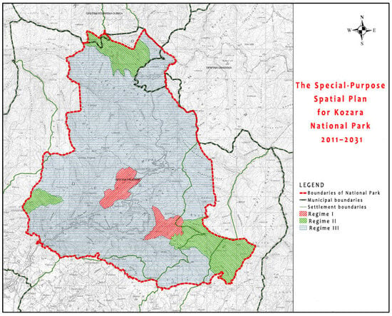
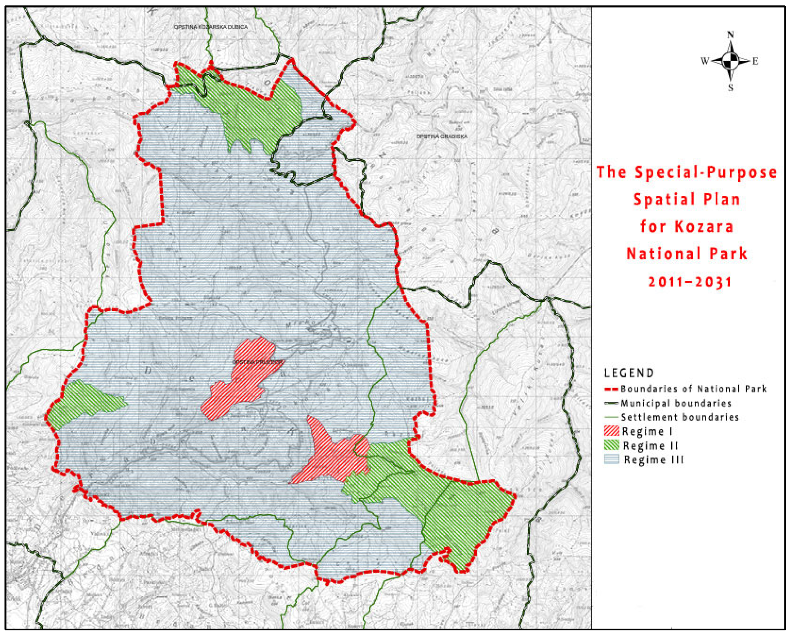
Kozara National Park (Figure 1) is a legally designated protected area characterized by a formally structured statutory zoning system and clearly differentiated protection regimes. It covers a total area of 39.08 km2 (3907.54 ha), as defined in the Special-Purpose Spatial Plan [22]. The Park operates under three legally defined degrees of protection (Regime I, II, and III) established in the Special-Purpose Spatial Plan [22] and confirmed by the Law on Kozara National Park [24]. The planning framework provides explicit spatial differentiation between strict ecological cores, controlled-use forest landscapes, tourism–recreation concentration areas, cultural–memorial sites, and infrastructure corridors [22,23]. The analytical framework is structured around five analytical units derived from statutory zoning and functional differentiation. The term “analytical units” refers to planning-relevant aggregations of statutory spatial zones and functional-use categories.
Figure 1.
Spatial structure of Kozara National Park: boundaries, protection regimes (I–III) and key analytical units defined in the Special-Purpose Spatial Plan (2011–2031).
The area combines forest ecosystems with a strong memorial and symbolic identity, particularly concentrated in the Mrakovica complex, which functions as both a cultural landmark and a tourism node [22,23]. The Park is exposed to visitor pressure, infrastructure-related stress, and climate-related disturbance factors within an environmentally sensitive landscape [8,9,20,23,25]. These characteristics make Kozara National Park analytically suitable for examining compatibility between conservation requirements and regulated development functions within a statutory land-use system.
Analytical units are derived directly from statutory zoning and functional differentiation defined in the Plan [22]. No artificial spatial subdivision or externally imposed territorial reclassification is introduced. For analytical clarity, the case study operationalizes five planning-relevant analytical units (n = 5) that aggregate statutory zones and key functional-use categories defined in the official instruments. The units represent planning-level spatial regimes rather than statistical sampling entities.
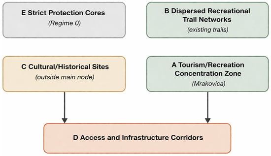
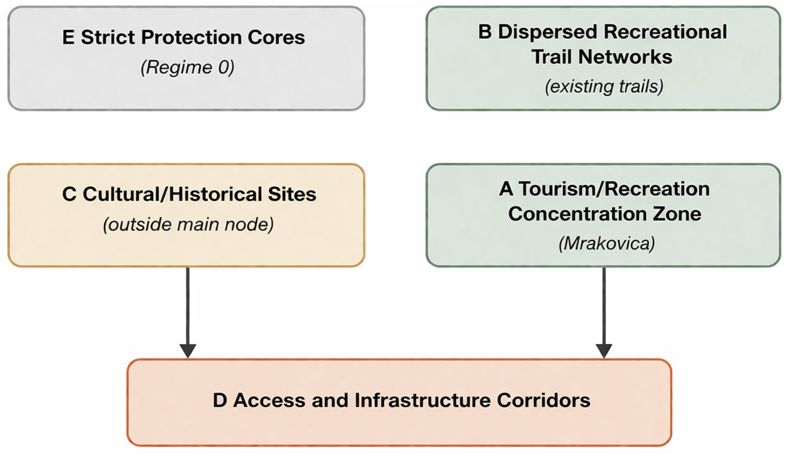
For comparative evaluation, five analytical units (A–E) are operationalized as planning-relevant aggregations of statutory zones and functional-use categories:
- A—Tourism–recreation concentration zone (Mrakovica and associated visitation areas) [22,23];
- B—Dispersed recreational trail networks and low-intensity use areas [22,23];
- C—Cultural–historical localities and memorial complexes (outside the main concentration node) [22,23];
- D—Access and infrastructure corridors [22];
- E—Strict protection cores (Regime I) [22,24].
These analytical units correspond directly to legally recognized zoning regimes and functional categories defined in the applicable planning and legal framework [22,24]. By aligning analytical units with statutory categories, the study ensures institutional coherence between model outputs and enforceable planning provisions. Compatibility indices, therefore, reflect planning-relevant spatial differentiation rather than abstract territorial subdivision. Figure 2 shows a schematic representation of the analytical units (A–E) aligned with statutory zoning.
Figure 2.
Conceptual diagram of analytical units (A–E) derived from statutory zoning and functional-use differentiation defined in the Special-Purpose Spatial Plan (2011–2031).
The use of a single case study is a deliberate methodological choice aimed at developing and testing the internal logic of the framework within a clearly defined statutory planning system, rather than enabling comparative generalization.
2.4. Criteria Structure and Theoretical Justification
The MCDA framework is structured around four criteria reflecting the dual mandate of protected areas: conservation integrity and regulated development under institutional constraints [4,5,8,9,25].
- C1. Ecological Integrity and Environmental Sensitivity (35%)
This criterion captures conservation status, ecosystem integrity, and sensitivity to disturbance within each analytical unit. It incorporates:
- Degree of naturalness and ecosystem preservation;
- Presence of strict protection regimes (Regime I) [22,24];
- Documented exposure to disturbance risks (e.g., fire sensitivity, erosion susceptibility, hydrological variability) [20,23];
- Monitoring and precautionary obligations defined in the Management Plan [23].
Climate-related exposure factors operate as modifiers of ecological compatibility rather than as independent variables. Where official documents indicate increased exposure to disturbances or management sensitivity, environmental outcomes reflect a reduced tolerance of additional anthropogenic pressure [20,23].
- C2. Cultural–Historical Significance (15%)
This criterion reflects the symbolic, memorial, and identity-related importance of analytical units, as documented in planning and management instruments. It accounts for:
- Officially recognized cultural–historical sites;
- Memorial complexes (e.g., Mrakovica) [22,23];
- Educational and interpretative functions embedded in statutory provisions [22,23];
- Public-interest recognition within planning objectives [22].
The weight allocation reflects the importance of heritage values while maintaining ecological primacy in accordance with national park protection requirements [4,5,22,23,24,25].
- C3. Tourism and Recreation Capacity under Controlled Use (30%)
This criterion evaluates the compatibility of each spatial analytical unit with regulated visitation and recreational development, consistent with zoning provisions. It includes:
- Permitted tourism modalities under Regimes II and III protection regimes [22,24];
- Infrastructure readiness and accessibility (as defined in the Plan) [22];
- Visitor concentration capacity and spatial distribution logic [8,9];
- Alignment with management-defined carrying-capacity considerations [8,9,23].
The criterion does not reward infrastructure intensity per se, but compatibility with statutory use regimes.
- C4. Socio-Economic Contribution and Governance Feasibility (20%)
This criterion captures the potential of spatial analytical units to contribute to local socio-economic objectives under controlled and legally permitted conditions. It reflects:
- Potential for employment and local benefit [23,25];
- Alignment with strategic development provisions [22,23];
- Governance feasibility and management-capacity requirements [2,3,4,5,6];
- Consistency with adaptive management logic [18].
The weighting configuration (35/15/30/20) reflects the normative hierarchy of national-park protection requirements: ecological integrity retains primacy, while tourism and socio-economic dimensions are recognized as secondary but legitimate functions under regulation [4,5,22,23,24,25]. The weights were defined based on normative planning priorities derived from statutory protection regimes and management objectives, rather than statistical calibration.
2.5. Scoring Protocol and Transparency
Each analytical unit is evaluated using a standardized five-point ordinal scale (1–5), interpreted as a compatibility scale within statutory protection regimes:
- 1—Very low compatibility within the protection mandate;
- 2—Low compatibility;
- 3—Moderate compatibility under specified conditions;
- 4—High compatibility under controlled management;
- 5—Very high compatibility is fully consistent with statutory intent.
Scores are assigned exclusively based on evidence derived from zoning provisions, permitted-use definitions, and management prescriptions contained in officially adopted statutory and planning instruments. A structured justification matrix links each assigned score to specific statutory clauses, planning provisions, or management objectives, ensuring methodological transparency and reproducibility [15,16,17,18].
Scoring was conducted through structured expert assessment using the Special-Purpose Spatial Plan [22], the Management Plan [23], and applicable legal provisions governing Kozara National Park [24]. Each criterion score (A–E, C1–C4) is accompanied by explicit documentary references and concise justification notes specifying the legal or managerial basis for evaluation.
To minimize interpretative bias, a conservative scoring principle was applied: where documentary provisions did not explicitly substantiate higher compatibility, lower-bound scores were assigned. Internal consistency checks were conducted across criteria to ensure alignment with the statutory hierarchy and protection logic.
The complete documentary justification matrix, including clause references and explanatory notes for all analytical units and criteria, is provided in the Supplementary Material (Table S1). This documentation enables independent replication of the scoring logic within the same statutory framework.
Table 1 summarizes the criteria structure, weight configuration, and evaluation basis applied in the MCDA framework.
Table 1.
MCDA scoring framework and weight configuration.
2.6. Aggregation Model
Composite compatibility indices are calculated using a Weighted Linear Combination (WLC):
where MCDAj denotes the composite compatibility index of analytical unit j; Wi represents the normalized weight assigned to criterion i (with the sum of all weights equal to 1); Sij denotes the ordinal score (1–5) of analytical unit j under criterion i; and m is the total number of criteria.
The objective of aggregation is comparative prioritization under statutory planning constraints rather than mathematical optimization. The WLC approach is widely applied in spatial multi-criteria analysis due to its interpretability, transparency, and compatibility with scenario testing and weight-variation procedures [13,15,17,18,26].
2.7. Scenario Design and Sensitivity Analysis
To test robustness under shifting policy orientations, three alternative weighting configurations are applied:
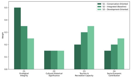
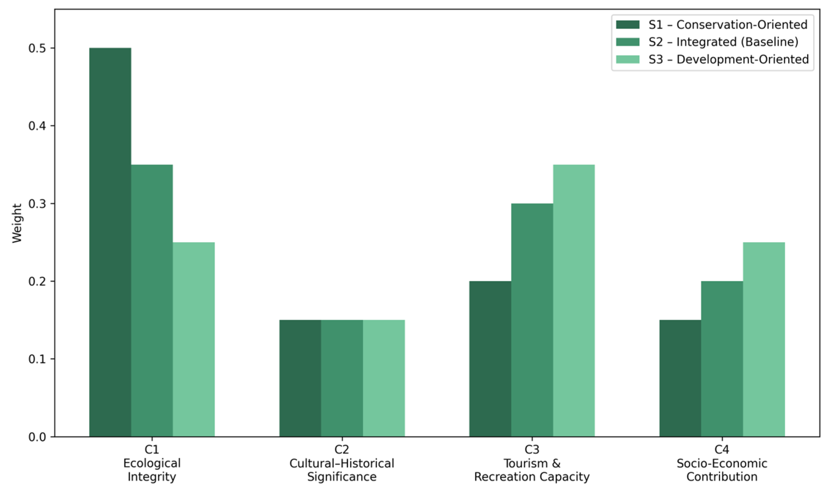
- S1—Conservation-Oriented Scenario. Weights: C1 = 0.50, C2 = 0.15, C3 = 0.20, C4 = 0.15.
- S2—Integrated Sustainable Development (Baseline). Weights: C1 = 0.35, C2 = 0.15, C3 = 0.30, C4 = 0.20.
- S3—Development-Oriented Scenario. Weights: C1 = 0.25, C2 = 0.15, C3 = 0.35, C4 = 0.25.
Weights were selected to represent three plausible policy orientations while maintaining cultural–historical weighting (C2) across scenarios and ensuring ∑Wi = 1 in all configurations (Figure 3).
Figure 3.
Alternative weighting configurations (S1–S3) were applied in the sensitivity analysis of the MCDA model.
Sensitivity analysis evaluates rank stability and elasticity across scenarios. Rank stability between alternative weighting configurations was additionally assessed using Spearman’s rank correlation coefficient (), calculated as:
di represents the difference between the ranks of analytical units under two weighting scenarios, and n denotes the number of analytical units.
This non-parametric measure evaluates monotonic agreement between scenario-based rankings and provides an indicator of structural robustness under shifting policy orientations. Given the limited number of analytical units (n = 5), the coefficient is interpreted as an indicative robustness metric rather than a test of statistical significance.
The use of Spearman’s coefficient in this study is strictly limited to internal model validation within a scenario-based planning framework and does not imply statistical generalization or inferential analysis.
Units demonstrating consistent ranking across scenarios are interpreted as structurally robust. Units exhibiting rank fluctuation are interpreted as management-dependent and may require stronger planning and management intervention to maintain compatibility [16,18].
2.8. Methodological Limitations
The methodological limitations of this study should be considered when interpreting the results [15,17]. The scoring procedure partially relies on structured expert judgment where uniform quantitative datasets are unavailable, which may introduce a degree of interpretative variance. In addition, zoning-based aggregation may obscure micro-scale ecological heterogeneity [15,16,17,18].
Further reflection on these limitations, including implications for the transferability of the model, is provided in Section 4.7.
3. Results
The results synthesize four analytically interconnected layers:
- The institutional–operational strength of the statutory planning framework;
- Spatial–functional differentiation derived from officially defined zoning regimes;
- The incorporation of climate-related sensitivity factors embedded in management provisions;
- Multi-criteria compatibility modelling combined with scenario-based robustness testing.
Together, these layers enable a systemic interpretation of how sustainability is structurally produced within the protected-area governance framework of Kozara National Park.
3.1. Institutional and Statutory Coherence of the Planning Framework
The analysis confirms the existence of a formally structured, legally binding zoning system organized around three protection regimes (Regimes I, II, and III) [22,24]. The Park boundary is precisely defined by cadastral coordinates and parcel references, ensuring juridical clarity and enforceability [22]. Within this framework, spatial organization is explicitly aligned with conservation objectives, visitor management logic, and controlled development provisions [22,23].
Regime I (strict protection) is designated for areas characterized by preserved or minimally altered ecosystems of exceptional scientific and ecological value. In these zones, construction is prohibited, visitor access is highly restricted, and natural succession processes are permitted to unfold with minimal anthropogenic interference [22,24]. The planning logic clearly positions these areas as ecological cores, reinforcing the primacy of biodiversity conservation [5,22].
Regime II (controlled protection) allows limited and regulated visitor use, minimal educational infrastructure, and traditional land-use practices under strict supervision [22,23].
Regime III permits selective and regulated development consistent with management objectives, including tourism-related construction and infrastructure upgrades by defined spatial and environmental conditions [22,23,24].
This hierarchical zoning structure demonstrates strong formal coherence and corresponds to internationally recognized protected-area governance principles emphasizing differentiated spatial regimes and layered management [4,5,19,26].
However, although the statutory framework clearly defines permitted uses and protection levels, it does not explicitly quantify cross-sectoral compatibility thresholds. Conservation and development functions are spatially allocated but are not systematically evaluated against each other in a measurable manner. The interaction between ecological integrity, cultural–symbolic values, tourism intensity, and socio-economic expectations, therefore, remains largely qualitative [4,5,25].
This observation confirms a structural implementation gap: zoning clarity alone does not automatically translate into measurable cross-sectoral compatibility. The MCDA framework was therefore introduced not to replace the statutory system, but to operationalize its implicit balancing logic [13,14,15,16,17,18].
3.2. Spatial–Functional Differentiation and Compatibility Profiles
The officially defined zoning and functional structure of Kozara National Park reveals a territorially differentiated system composed of:
- Strict ecological cores (Regime I) [22,24];
- Controlled-use forest landscapes (Regime II) [22];
- Tourism and recreation concentration zones (including Mrakovica and associated infrastructure) [22,23];
- Cultural-memorial complexes [22,23];
- Dispersed trail networks [22,23];
- Infrastructure corridors and access routes [22].
When evaluated across the four criteria—Ecological Integrity (35%), Cultural–Historical Significance (15%), Tourism Capacity (30%), and Socio-Economic Contribution (20%)—distinct compatibility configurations emerge [13,14,15,16,17,18].
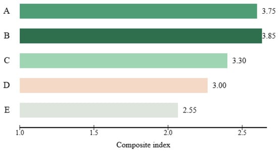
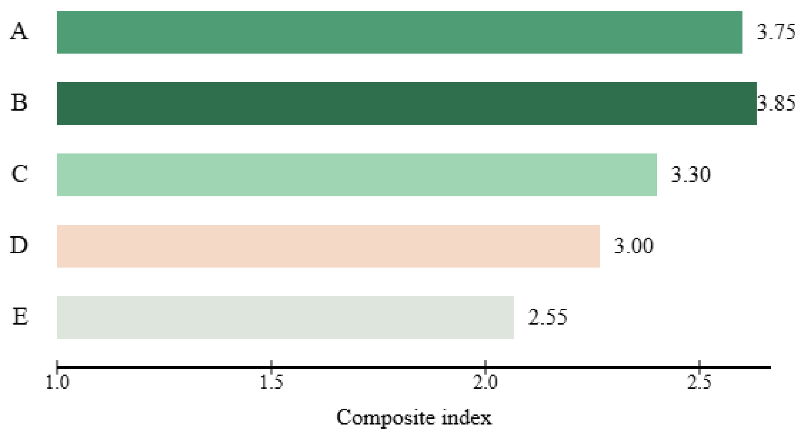
Table 2 and Figure 4 present the criterion-level scores and resulting composite compatibility indices for each analytical unit under the baseline weighting configuration (35/15/30/20).
Table 2.
Compatibility Scores and Composite Indices of Analytical Units.
Figure 4.
Composite compatibility ranking of analytical units under baseline weighting (35/15/30/20). A—Tourism concentration (Mrakovica); B—Dispersed recreational networks; C—Cultural–historical localities; D—Infrastructure corridors; E—Strict protection cores.
Detailed documentary justification for individual criterion scores is provided in Supplementary Table S1.
Composite values range from 2.55 to 3.85, indicating differentiated structural alignment across spatial units.
Dispersed hiking and recreational trail systems achieve the highest composite compatibility score (3.85). Their spatial dispersion distributes visitor pressure, minimizes concentrated infrastructure loads, and maintains ecological thresholds within tolerable margins. Unlike infrastructure-intensive nodes, their compatibility profile is not driven by a single dominant dimension but reflects balanced cross-criterion alignment. This finding is consistent with broader evidence suggesting that low-intensity, distributed recreation models generate lower cumulative ecological conflict while maintaining socio-economic benefits [8,9].
Mrakovica, as the central memorial and tourism zone, demonstrates a high composite value (3.75), yet with a structurally asymmetrical configuration. Cultural–historical significance and tourism capacity receive maximal scores, whereas ecological compatibility remains constrained. This indicates compensatory compatibility: development attractiveness numerically offsets ecological sensitivity. Such asymmetry implies governance dependence; sustainability in this node is contingent upon strict management control rather than fundamental spatial resilience [4,8,9].
Cultural–historical localities outside the main concentration node exhibit moderate compatibility (3.30). Their symbolic value is substantial, yet development expansion is spatially constrained by protection regimes [22,23]. These areas function primarily as interpretative and commemorative landscapes rather than infrastructural growth zones.
Infrastructure corridors display intermediate compatibility (3.00). While necessary for access and operational functionality, they introduce fragmentation and anthropogenic disturbance [27,28]. Their sustainability depends strongly on development standards, monitoring mechanisms, and mitigation measures [4,23].
Strict protection cores (2.55) exhibit the highest ecological score but the lowest development compatibility. Their low composite index does not indicate weakness; rather, it confirms their systemic role as ecological stabilizers within the protected-area network [5,22,24]. Their function is not to generate multi-dimensional balance but to anchor ecological integrity.
The compatibility matrix thus reveals three structural archetypes:
- Intrinsically balanced zones (dispersed recreation);
- Management-dependent high-attraction nodes (Mrakovica-type);
- Conservation-dominant ecological anchors (Regime I cores).
Sustainability within Kozara National Park, therefore, emerges not from uniform development, but from relational interaction among differentiated zones within a multi-level statutory framework.
3.3. Climate-Related Sensitivity and Ecological Threshold Adjustment
The Management Plan identifies forest fire exposure, erosion susceptibility, and hydrological variability as relevant disturbance factors within the Park [23]. These risk signals were incorporated into the ecological integrity criterion as compatibility modifiers.
In concentration zones such as Mrakovica, seasonal visitor peaks combined with dry conditions increase fire vulnerability and soil degradation risk [20,21,23]. On erosion-prone slopes, infrastructure intensification amplifies geomorphological instability. These cumulative pressures effectively narrow acceptable intervention thresholds.
Dispersed trail networks demonstrate greater adaptive resilience. Lower infrastructure density reduces disturbance concentration, allowing ecological systems to absorb visitor flows with reduced cumulative impact [8,9].
The results therefore confirm that climate sensitivity operates as a threshold modifier of ecological compatibility rather than as an externally imposed variable. Development feasibility must be interpreted as conditional upon disturbance exposure. Static zoning categories alone cannot fully capture this variability; adaptive management logic becomes essential [18,20].
3.4. Scenario Stability and Rank Elasticity
Sensitivity analysis tested three weighting scenarios: conservation-oriented, integrated balanced, and development-oriented [15,16,17,18].
Rank correlation analysis indicates strong structural stability between both alternative weighting configurations and the baseline scenario (Spearman’s ≈ 0.90 for both S1–S2 and S3–S2 comparisons), indicating limited rank reordering. Rank reordering is limited to single-position shifts across scenarios. Composite indices and rank positions for all alternative weighting scenarios are provided in Supplementary Table S2.
Dispersed recreational units rank first under S1 and S2 and second under S3, indicating strong cross-scenario robustness.
Mrakovica exhibits moderate rank sensitivity. Under conservation-oriented weighting, its composite value decreases while its rank position remains second. Under development-oriented weighting, it improves to first position, confirming governance dependence and sensitivity to shifting policy priorities [4,18]. Strict protection zones remain consistently low in development ranking, reinforcing their ecological constancy across scenarios [5,22].
The integrated sustainable development configuration produces the most coherent system-wide distribution, preserving ecological hierarchy while enabling controlled use. This suggests that balanced weighting reduces systemic volatility compared to polarized policy orientations [15,18].
3.5. Synthetic System Interpretation
The combined findings demonstrate that sustainability in Kozara National Park is structurally relational. It does not derive from maximizing tourism intensity nor from categorical exclusion alone, but from structured compatibility across spatially differentiated regimes.
The statutory zoning framework provides a strong structural foundation [22,23,24]. However, its operational effectiveness depends on measurable cross-criterion evaluation and adaptive threshold management [13,14,15,16,17,18].
Dispersed, low-intensity spatial configurations exhibit structural compatibility robustness [8,9]. High-symbolic-attraction nodes display compensatory compatibility requiring sustained governance oversight [4,23]. Strict protection cores function as ecological anchors conditioning overall system resilience [5,22].
Climate-related vulnerability further narrows tolerance margins, reinforcing the necessity of precautionary planning and adaptive monitoring mechanisms [20,23].
The results confirm that formal zoning coherence does not automatically translate into measurable cross-sectoral compatibility. Sustainability emerges when statutory clarity is combined with structured multi-criteria evaluation capable of revealing relational trade-offs within institutionally bounded land-use systems [13,14,15,16,17,18].
4. Discussion
4.1. From Zoning Formalism to Measurable Compatibility
The findings demonstrate that Kozara National Park operates within a formally coherent statutory planning framework structured around clearly differentiated protection regimes (I, II, and III degrees of protection) [22,24]. The Special-Purpose Spatial Plan establishes legally binding zoning categories, defines permitted activities, and specifies implementation provisions [22]. However, as shown by the analytical framework applied in this study, formal zoning clarity does not automatically translate into measurable cross-sectoral compatibility. Zoning differentiation provides structural allocation but not evaluative calibration. In other words, spatial regimes may be clearly defined, yet their cross-sectoral performance remains unquantified without structured compatibility assessment.
This distinction is critical. In many protected-area systems, planning effectiveness is equated with the existence of hierarchically structured protection categories. Yet contemporary governance scholarship increasingly emphasizes that sustainability depends not only on regulatory differentiation but on the capacity to systematically and transparently evaluate interactions between conservation protection requirements, tourism functions, and socio-economic expectations [2,4,5].
The Kozara case confirms that statutory planning can provide a stable structural foundation while still lacking explicit compatibility articulation. The MCDA framework introduced here does not replace zoning logic; rather, it operationalizes it. By quantifying how different spatial analytical units perform simultaneously across ecological, cultural, tourism, and socio-economic dimensions, the model translates qualitative planning prescriptions into measurable relational profiles [13,14,15,16,17,18].
This contribution aligns with broader calls in the land-use governance literature to move from declarative recognition toward instrument-based operationalization of sustainability trade-offs [3,6,7]. Comparable integrative approaches linking cultural and natural heritage within structured planning systems have been documented in other protected and culturally significant landscapes, further underscoring the importance of governance-based operationalization beyond declarative recognition [29,30].
Beyond the Kozara case, the analytical framework developed in this study demonstrates strong transferability potential to other protected areas and comparable governance contexts. The model is not dependent on site-specific ecological parameters but is structured around universally applicable planning elements, including statutory zoning systems, protection regimes, and regulated land-use functions.
Its applicability is particularly relevant in planning systems where legally binding instruments define spatial differentiation but lack explicit mechanisms for evaluating cross-sectoral compatibility. By aligning analytical units with statutory categories and embedding Multi-Criteria Decision Analysis within existing planning hierarchies, the framework can be adapted to diverse institutional settings without requiring substantial modification of its core structure.
While the specific criteria weights and scoring parameters may require contextual calibration depending on ecological conditions, governance capacity, and policy priorities, the underlying methodological logic remains broadly applicable. This makes the model suitable for use in other national parks, protected landscapes, and transitional planning systems where balancing conservation and development objectives remains a central planning challenge.
4.2. Sustainability as a Relational Planning Structure
A central theoretical insight emerging from this study is that sustainability within protected landscapes is relational rather than additive. High development potential in one dimension does not necessarily equate to overall system resilience. Instead, sustainability emerges from the structured interaction among differentiated spatial regimes.
The compatibility matrix shows that dispersed, low-intensity recreational configurations demonstrate the highest structural robustness across scenarios. Their performance is not driven by dominance in a single criterion but by cross-criterion alignment. Such zones distribute visitor pressure, maintain ecological thresholds within tolerable margins, and generate socio-economic benefits without concentrated infrastructural stress [8,9].
This finding reinforces international evidence suggesting that dispersed tourism models reduce cumulative ecological conflict compared to highly concentrated nodes [8,9]. It also supports adaptive landscape management theories that emphasize functional distribution and pressure diffusion as core resilience mechanisms [4,5].
Conversely, infrastructure-intensive and symbolically concentrated nodes—such as Mrakovica—exhibit compensatory compatibility. Their strong cultural and tourism value numerically offsets ecological sensitivity. However, this compensation is management-dependent. Without sustained regulatory oversight, monitoring, and visitor-flow control, such zones risk ecological overshoot [4,8].
This distinction differentiates intrinsically resilient configurations from management-dependent ones. These findings reinforce the interpretation of climate sensitivity as a threshold modifier of ecological compatibility within statutory land-use regimes [2,3,6].
4.3. Climate Sensitivity and Dynamic Thresholds
The incorporation of climate-related vulnerability signals—explicitly identified in the Management Plan—introduces a dynamic dimension to compatibility assessment [23]. Forest fire exposure, erosion susceptibility, and hydrological variability function as threshold modifiers, effectively narrowing tolerance margins for development in sensitive zones.
Emerging scholarship indicates that climate variability transforms protected landscapes into dynamic regulatory environments [20,21]. Static zoning categories cannot fully account for disturbance regimes that alter ecological carrying capacity over time.
In Kozara National Park, climate sensitivity disproportionately affects high-attraction nodes where visitor concentration amplifies exposure. Dispersed recreational systems display greater adaptive resilience due to lower infrastructural density and spatial flexibility [8,9].
The implication is clear: adaptive governance instruments must complement statutory zoning. Monitoring systems, precautionary development thresholds, and flexible management responses become integral components of sustainable planning [4,18].
Sustainability, therefore, is not a fixed spatial outcome but a continuously recalibrated equilibrium conditioned by environmental variability.
4.4. Scenario Elasticity and Governance Dependence
Sensitivity testing further clarifies structural robustness patterns. Dispersed recreational zones remain stable under varying weight configurations, indicating structural compatibility [15,16,17,18].
In contrast, Mrakovica demonstrates rank elasticity across scenarios. Under development-oriented weighting, its compatibility strengthens; under conservation-oriented weighting, it declines. This elasticity reveals governance dependence: sustainability in such nodes is contingent upon sustained management intensity and regulatory discipline [4,18].
Strict protection cores remain consistently low in development ranking, confirming their systemic role as ecological anchors [5,22].
The integrated sustainable development scenario yields the most coherent configuration, preserving ecological hierarchy while permitting controlled development. This supports integrative governance models that avoid polarization between conservation maximalism and development dominance [3,6,7].
4.5. Implications for Transitional Planning Systems
The Republic of Srpska operates within evolving institutional capacities, sectoral coordination constraints, and historically fragmented land-management structures typical of transitional governance contexts [31,32,33]. The Kozara case demonstrates that statutory clarity alone does not guarantee operational sustainability.
Four practical implications emerge:
- Compatibility evaluation mechanisms should be embedded within statutory planning instruments, moving beyond descriptive zoning toward measurable multi-criteria assessment [13,14,15,16,17,18].
- Dispersed, low-intensity tourism models should be prioritized in ecologically sensitive landscapes due to their structural robustness [8,9].
- High-attraction nodes require adaptive management frameworks integrating visitor regulation, monitoring, and climate-risk mitigation [4,20,23].
- Strict protection zones must remain ecologically uncompromised, as their integrity conditions system-wide stability [5,22].
These conclusions resonate with international land-use governance research emphasizing integrated, scenario-based planning approaches for complex protected landscapes [3,34,35].
From a practical planning perspective, the proposed framework can support decision-making by providing a transparent and reproducible basis for evaluating trade-offs between conservation and development objectives within statutory constraints. This is particularly relevant in contexts with limited institutional capacity, where planning decisions are often made under conditions of incomplete data and constrained administrative resources.
By structuring complex interactions into clearly defined criteria, weights, and compatibility scores, the model enables planners to identify priority areas, anticipate potential conflicts, and justify planning interventions in a more systematic and evidence-based manner.
4.6. Methodological Contribution
The primary methodological contribution of this study lies in embedding MCDA within the statutory planning framework rather than applying it as an isolated optimization exercise [13,14,15,16,17,18]. Analytical units were aligned with legally defined zoning categories [22], ensuring institutional compatibility between model outputs and regulatory applicability.
This alignment enhances practical transferability. The framework does not impose an external evaluation logic; instead, it renders visible the balancing mechanisms already embedded within planning documents.
By combining normative institutional analysis with multi-criteria modelling and scenario testing, the study bridges the gap between governance theory and operational land-use planning [3,6,7].
4.7. Limitations and Research Directions
The study is subject to certain limitations. The scoring procedure partially relies on structured expert judgment where uniform quantitative datasets are unavailable, which may introduce a degree of interpretative variance. In addition, zoning-based aggregation may obscure micro-scale ecological heterogeneity [13,17]. These limitations should be considered when interpreting the results as planning-level prioritization rather than fine-scale ecological assessment.
Future research could further develop the proposed framework through the integration of spatially explicit GIS-based analyses, higher-resolution environmental datasets, and participatory weight elicitation involving stakeholders, as well as through cross-case comparative testing across multiple protected landscapes [13,14,15,16,17,18,36]. Such extensions would enable more detailed spatial calibration of compatibility assessments and support more fine-grained planning interventions.
4.8. Integrative Reflection
The Kozara case demonstrates that protected landscapes achieve resilience not by eliminating development nor by maximizing it, but by calibrating compatibility within measurable ecological and institutional limits.
Heritage integration becomes sustainable when statutory zoning is complemented by transparent compatibility evaluation capable of revealing relational trade-offs [13,14,15,16,17,18].
In this sense, sustainability in protected areas is neither a categorical designation nor a political slogan. It is a structured, scenario-sensitive equilibrium maintained through governance capacity, adaptive thresholds, and cross-sectoral balance [2,3,6].
5. Conclusions
This study examined whether cultural and natural heritage within protected areas can move beyond declarative recognition in statutory planning documents toward measurable operational integration within land-use decision-making systems [37].
Using Kozara National Park as an empirical case, the research combined an institutional analysis of legally binding planning instruments [22,23,24] with a structured multi-criteria decision framework grounded in established MCDA methodologies [13,14,15,16,17,18,26]. By embedding the analytical model within the statutory zoning architecture rather than applying it as an external optimization tool, the study ensured institutional compatibility between evaluative outputs and enforceable land-use regimes.
The findings demonstrate that sustainability in protected landscapes does not arise from categorical protection alone, nor from the maximization of development intensity. Rather, it emerges from structured compatibility between ecological thresholds, cultural-symbolic values, tourism functions, and socio-economic feasibility within legally defined spatial regimes [2,4,5].
Three structural insights stand out.
- Dispersed and low-intensity recreational configurations exhibit structural robustness across alternative weighting scenarios [8,9,15,16,17,18]. Their resilience derives from cross-criterion alignment rather than dominance in a single dimension, confirming that distributed visitor systems can reduce cumulative ecological pressure while maintaining socio-economic functionality.
- Infrastructure-intensive and symbolically concentrated nodes—such as the Mrakovica complex—demonstrate management-dependent compatibility [4,23]. Their sustainability is contingent upon sustained regulatory oversight, monitoring capacity, and adaptive management mechanisms capable of preventing ecological overshoot under fluctuating visitation pressure.
- Strict protection zones function as systemic ecological anchors within the protected-area network [5,22,24]. Their relatively low composite compatibility score reflects their conservation mandate rather than structural weakness; their integrity conditions overall spatial resilience and sets non-negotiable ecological thresholds for adjacent development regimes.
By incorporating climate-related vulnerability signals explicitly recognized in official management documents [23] and situating them within broader climate scholarship [20,21], the study confirms that compatibility thresholds are dynamic rather than static. Sustainability in forested protected landscapes is therefore shaped not only by zoning differentiation but by adaptive recalibration under disturbance exposure.
The principal scientific contribution lies in repositioning MCDA as an embedded governance instrument within statutory planning systems [13,14,15,16,17,18,26]. Instead of substituting zoning logic, the framework renders explicit the implicit balancing mechanisms already structured into legally binding plans [22]. In doing so, it bridges heritage governance theory and operational land-use practice, contributing to broader debates on adaptive spatial governance and institutionalized decision-support mechanisms [3,6,7].
More broadly, the Kozara case demonstrates that sustainability in protected landscapes is fundamentally relational. It is neither a categorical designation nor a development prohibition, but a structured equilibrium maintained within measurable ecological limits and institutional capacities. Protected areas remain resilient not because they are insulated from change, but because change is governed through differentiated spatial regimes, transparent compatibility evaluation, and adaptive management anchored in statutory authority.
Beyond the case study, the proposed methodological framework demonstrates broader applicability to other protected areas and comparable planning contexts, particularly where statutory zoning systems structure land-use decisions but lack explicit tools for evaluating cross-sectoral compatibility.
Supplementary Materials
The following supporting information can be downloaded at https://www.mdpi.com/article/10.3390/land15040596/s1, Table S1: Documentary Justification Matrix for MCDA Scoring; Table S2: Composite Compatibility Indices under Alternative Weighting Scenarios.
Author Contributions
Conceptualization, N.Ž. and I.M.-T.; methodology, N.Ž.; software, M.T.; validation, N.Ž. and I.M.-T.; formal analysis, B.Z.P.; investigation, V.Č. and D.G.S.; resources, M.T. and B.Z.P.; data curation, B.Z.P.; writing—original draft preparation, N.Ž. and I.M.-T.; writing—review and editing, N.Ž. and I.M.-T.; visualization, M.T.; supervision, N.Ž.; project administration, N.Ž.; funding acquisition, N.Ž. All authors have read and agreed to the published version of the manuscript.
Funding
The research was supported by the Ministry of Scientific and Technological Development and Higher Education, Government of the Republic of Srpska (Project No. 1259090).
Data Availability Statement
The original contributions presented in this study are included in the article.
Conflicts of Interest
The authors declare no conflicts of interest.
References
- UNESCO. Recommendation on the Historic Urban Landscape (HUL); UNESCO: Paris, France, 2011; Available online: https://whc.unesco.org/en/hul/ (accessed on 19 February 2026).
- Lockwood, M. Good governance for terrestrial protected areas: A framework, principles and performance outcomes. J. Environ. Manag. 2010, 91, 754–766. [Google Scholar] [CrossRef] [Scilit] [PubMed]
- Krawchenko, T.; Tomaney, J. The governance of land use: A conceptual framework. Land 2023, 12, 608. [Google Scholar] [CrossRef] [Scilit]
- Hockings, M.; Stolton, S.; Leverington, F.; Dudley, N.; Courrau, J. Evaluating Effectiveness: A Framework for Assessing Management Effectiveness of Protected Areas, 2nd ed.; IUCN: Gland, Switzerland, 2006; Available online: https://www.google.com/url?sa=t&source=web&rct=j&opi=89978449&url=https://portals.iucn.org/library/efiles/documents/pag-014.pdf&ved=2ahUKEwiYgoSKgPCSAxVh_7sIHQPWB8MQFnoECBsQAQ&usg=AOvVaw0ZWlU6BVaJZHuVrdU4UjFM (accessed on 19 February 2026).
- Dudley, N. (Ed.) Guidelines for Applying Protected Area Management Categories; IUCN: Gland, Switzerland, 2008; Available online: https://www.google.com/url?sa=t&source=web&rct=j&opi=89978449&url=https://portals.iucn.org/library/sites/library/files/documents/pag-021.pdf&ved=2ahUKEwiQraHYgPCSAxWlgv0HHe1YOfsQFnoECCAQAQ&usg=AOvVaw1z-LZbGmfWfkgw8-XnTZ6a (accessed on 19 February 2026).
- Healey, P. Collaborative Planning: Shaping Places in Fragmented Societies, 2nd ed.; Palgrave Macmillan: London, UK, 2006. [Google Scholar]
- Albrechts, L. Strategic (spatial) planning reexamined. Environ. Plan. B Plan. Des. 2004, 31, 743–758. [Google Scholar] [CrossRef] [Scilit]
- McCool, S.F.; Lime, D.W. Tourism carrying capacity: Tempting fantasy or useful reality? J. Sustain. Tour. 2001, 9, 372–388. [Google Scholar] [CrossRef] [Scilit]
- Manning, R.E. Studies in Outdoor Recreation: Search and Research for Satisfaction, 3rd ed.; Oregon State University Press: Corvallis, OR, USA, 2011. [Google Scholar]
- Bandarin, F.; van Oers, R. The Historic Urban Landscape: Managing Heritage in an Urban Century; Wiley-Blackwell: Chichester, UK, 2012. [Google Scholar]
- Tengberg, A.; Fredholm, S.; Eliasson, I.; Knez, I.; Saltzman, K.; Wetterberg, O. Cultural ecosystem services provided by landscapes: Assessment of heritage values and identity. Ecosyst. Serv. 2012, 2, 14–26. [Google Scholar] [CrossRef] [Scilit]
- Graham, B.; Ashworth, G.J.; Tunbridge, J.E. A Geography of Heritage: Power, Culture and Economy; Arnold: London, UK, 2000. [Google Scholar]
- Malczewski, J. GIS-based multicriteria decision analysis: A survey of the literature. Int. J. Geogr. Inf. Sci. 2006, 20, 703–726. [Google Scholar] [CrossRef] [Scilit]
- Saaty, T.L. The Analytic Hierarchy Process; McGraw-Hill: New York, NY, USA, 1980. [Google Scholar]
- Belton, V.; Stewart, T.J. Multiple Criteria Decision Analysis: An Integrated Approach; Springer: Boston, MA, USA, 2002. [Google Scholar]
- Triantaphyllou, E. Multi-Criteria Decision Making Methods: A Comparative Study; Springer: Boston, MA, USA, 2000. [Google Scholar]
- Mendoza, G.A.; Martins, H. Multi-criteria decision analysis in natural resource management: A critical review of methods and new modelling paradigms. For. Ecol. Manag. 2006, 230, 1–22. [Google Scholar] [CrossRef] [Scilit]
- Linkov, I.; Satterstrom, F.K.; Kiker, G.; Batchelor, C.; Bridges, T.; Ferguson, E. From comparative risk assessment to multi-criteria decision analysis and adaptive management: Recent developments and applications. Environ. Int. 2006, 32, 1072–1093. [Google Scholar] [CrossRef] [Scilit] [PubMed]
- Liu, J.; Huang, X.; Guo, H.; Zhang, Z.; Li, X.; Ge, M. Functional zoning method for national park planning: A case study of Ailaoshan–Wuliangshan National Park. Land 2022, 11, 1882. [Google Scholar] [CrossRef] [Scilit]
- IPCC (Intergovernmental Panel on Climate Change). Climate Change 2022: Impacts, Adaptation and Vulnerability. Contribution of Working Group II to the Sixth Assessment Report of the Intergovernmental Panel on Climate Change; Pörtner, H.-O., Roberts, D.C., Tignor, M., Poloczanska, E.S., Mintenbeck, K., Alegría, A., Craig, M., Langsdorf, S., Löschke, S., Möller, V., et al., Eds.; Cambridge University Press: Cambridge, UK, 2022. [Google Scholar] [CrossRef] [Scilit]
- Scott, D.; Gössling, S.; Hall, C.M. International tourism and climate change. Wiley Interdiscip. Rev. Clim. Change 2012, 3, 213–232. [Google Scholar] [CrossRef] [Scilit]
- Institut za Građevinarstvo “IG” Banja Luka; JP “Zavod za Urbanizam Vojvodine” Novi Sad. Prostorni Plan Područja Posebne Namjene Nacionalni park Kozara 2011–2031 [The Special-Purpose Spatial Plan for Kozara National Park 2011–2031]; Institut za Građevinarstvo “IG” Banja Luka; JP “Zavod za Urbanizam Vojvodine” Novi Sad: Banja Luka, Republic of Srpska, 2014. (In Serbian) [Google Scholar]
- Javna Ustanova Nacionalni Park “Kozara”. Plan Upravljanja Nacionalnim Parkom “Kozara” (2014–2029) [Management Plan of Kozara National Park (2014–2029)]; Javna Ustanova Nacionalni Park “Kozara”: Banja Luka, Bosnia and Herzegovina, 2013; Available online: https://npkozara.com/wp-content/uploads/2020/03/plan-upravljanja.pdf (accessed on 19 February 2026). (In Serbian)
- The Official Gazette of the Republic of Srpska. Zakon o Nacionalnom parku “Kozara” [Law on Kozara National Park]; Official Gazette of the Republic of Srpska No. 121/12; Government of the Republic of Srpska: Banja Luka, Republic of Srpska, 2012. (In Serbian) [Google Scholar]
- Eagles, P.F.J.; McCool, S.F.; Haynes, C.D. Sustainable Tourism in Protected Areas: Guidelines for Planning and Management; IUCN: Gland, Switzerland; Cambridge, UK, 2002; Available online: https://www.google.com/url?sa=t&source=web&rct=j&opi=89978449&url=https://portals.iucn.org/library/sites/library/files/documents/pag-008.pdf&ved=2ahUKEwilhdLYg_CSAxUC_7sIHf9fJBgQFnoECBcQAQ&usg=AOvVaw0EDVToad_rN3M60x-7TJg0 (accessed on 19 February 2026).
- Geneletti, D.; van Duren, I. Protected area zoning for conservation and use: A combination of spatial multicriteria and multiobjective evaluation. Landsc. Urban Plan. 2008, 85, 97–110. [Google Scholar] [CrossRef] [Scilit]
- Geneletti, D. Biodiversity impact assessment of roads: An approach based on ecosystem rarity. Environ. Impact Assess. Rev. 2003, 23, 343–365. [Google Scholar] [CrossRef] [Scilit]
- Geneletti, D.; Dawa, D. Environmental impact assessment of mountain tourism in developing regions: A study in Ladakh, Indian Himalaya. Environ. Impact Assess. Rev. 2009, 29, 229–242. [Google Scholar] [CrossRef] [Scilit]
- Faganel, A.; Trnavčević, A. Sustainable Natural and Cultural Heritage Tourism in Protected Areas: Case Study. Annales 2012, 22, 19–29. [Google Scholar] [CrossRef] [Scilit]
- Marinković, G.; Vasiljević, Z.; Bajić, B.; Kovačević, B. Sensitivity of multi-criteria analysis methods in rural land consolidation decision-making. Land 2024, 13, 245. [Google Scholar] [CrossRef] [Scilit]
- Sklenicka, P.; Salek, M. Ownership and soil quality as sources of agricultural land fragmentation in highly fragmented ownership patterns. Land. Use Policy 2008, 25, 69–76. [Google Scholar] [CrossRef] [Scilit]
- Medar-Tanjga, I.; Živak, N. Cultural Heritage of the Republic of Srpska—Identity Codes of the Past, Present, and Future. In Proceedings of the International Scientific Conference the 5th Congress of Slavic Geographers and Ethnographers Book of Abstracts and Contributed Papers, Belgrade, Serbia, 23–25 October 2024; Geographical Institute “Jovan Cvijić” SASA: Belgrade, Serbia, 2024; pp. 371–386. Available online: https://doi.ub.kg.ac.rs/doi/10-46793-csge5-371imt/ (accessed on 19 February 2026).
- Živak, N.; Medar-Tanjga, I. The Natural and Cultural Heritage of the Republic of Srpska–Institutional Jurisdiction, Legal Framework, Planning and Strategic Perspectives. In Innovative Approach and Perspectives of the Applied Geography, Collection of Papers; University of Novi Sad: Novi Sad, Serbia, 2021; pp. 203–212. Available online: https://www.dgt.uns.ac.rs/dokumentacija/projekti/peti-kongres/collectionof-papers.pdf (accessed on 19 February 2026).
- Plieninger, T.; Bieling, C.; Fagerholm, N.; Byg, A.; Hartel, T.; Hurley, P.; López-Santiago, C.A.; Nagabhatla, N.; Oteros-Rozas, E.; Raymond, C.M.; et al. The role of cultural ecosystem services in landscape management and planning. Curr. Opin. Environ. Sustain. 2015, 14, 28–33. [Google Scholar] [CrossRef] [Scilit]
- Chan, K.M.A.; Satterfield, T.; Goldstein, J. Rethinking ecosystem services to better address and navigate cultural values. Ecol. Econ. 2012, 74, 8–18. [Google Scholar] [CrossRef] [Scilit]
- Herzberg, R.; Fritz, S.; See, L.; McCallum, I.; Obersteiner, M. Multi-criteria decision analysis for the land evaluation of conservation and development alternatives. Land 2019, 8, 90. [Google Scholar] [CrossRef] [Scilit]
- Medar-Tanjga, I.; Živak, N.; Ivkov-Džigurski, A.; Rajčević, V.; Mišlicki Tomić, T.; Čolić, V. Drina Transboundary Biosphere Reserve—Opportunities and Challenges of Sustainable Conservation. Sustainability 2022, 14, 16733. [Google Scholar] [CrossRef] [Scilit]

Disclaimer/Publisher’s Note: The statements, opinions and data contained in all publications are solely those of the individual author(s) and contributor(s) and not of MDPI and/or the editor(s). MDPI and/or the editor(s) disclaim responsibility for any injury to people or property resulting from any ideas, methods, instructions or products referred to in the content. |
© 2026 by the authors. Licensee MDPI, Basel, Switzerland. This article is an open access article distributed under the terms and conditions of the Creative Commons Attribution (CC BY) license.