1. Introduction
Agricultural heritage systems are living social–ecological systems produced and maintained by farmers, households, and collective institutions through long-term local adaptation, agricultural production, and community life. They embody agrobiodiversity, traditional knowledge, ecosystem services, landscape aesthetics, and place identity [
1,
2]. Degradation therefore concerns not only visible material change but also the weakening of practices and institutional arrangements that keep the landscape functioning. Previous studies have advocated integrated landscape approaches that incorporate livelihood security, multifunctional land use, community participation, and multilevel governance, supported by monitoring for adaptive conservation and management [
3,
4,
5]. Research in China has likewise progressed from conceptual and value-oriented discussions to landscape identification, evolution, and conservation practice [
6]. From a landscape architecture perspective, conservation does not mean freezing a historical appearance; rather, it entails maintaining functional relationships among the natural setting, production spaces, settlement form, landscape infrastructure, cultural practices, and the people who sustain them.
Studies in China have documented changes in the spatial patterns and production practices of rice-based cultural landscapes, Linpan settlements in western Sichuan, composite agricultural systems, and dryland stone-ridge terrace systems [
7,
8,
9,
10,
11,
12]. International research shows that mountain terrace abandonment is shaped jointly by declining returns, plot fragmentation, generational turnover, limited accessibility, rising maintenance costs, and insufficient institutional support, while its ecological consequences vary with climate, soils, and management scale [
13,
14,
15,
16]. Studies in China have further identified slope, irrigation conditions, cultivation radius, constraints on mechanization, and household livelihood choices as relevant factors [
17,
18,
19,
20]. Experiences from Ifugao and Ziquejie also show that preserving emblematic landscapes while neglecting farmer livelihoods, building use, and community action can create tension between outward appearance and the living substance of heritage [
21,
22]. It is therefore necessary to examine separately whether households continue cultivation, how they cultivate, and how they renew their living spaces. Although all three processes are embedded in livelihood transition, they operate at different behavioral thresholds and spatial scales. Combining them into a single degradation index would obscure their distinct processes and actionable points of intervention.
In nineteenth-century European social theory, Marx’s contested discussion of the ‘Asiatic form’ connected communal property with collective organization in agrarian societies [
23]. Rather than applying that macrohistorical category directly to Fengyan, this study follows contemporary commons scholarship in examining locally negotiated water allocation, maintenance responsibilities, and collective action. Research on traditional irrigation has shifted from preserving physical facilities toward community governance and institutional adaptation. Evidence from multiple countries and across Asia indicates that the continuity of farmer-managed irrigation systems depends on water allocation, the distribution of maintenance responsibilities, perceptions of fairness, and community participation. Rural out-migration can also reorganize canal maintenance through changes in household labor allocation and institutional rules [
24,
25,
26,
27]. Irrigation continuity thus has physical, hydrological, and institutional dimensions, and a single area-based indicator cannot substitute for direct measurement of water availability, water rights, rotational irrigation, or conflict mediation. Research on traditional settlements has similarly moved beyond preserving authentic form toward community-led rehabilitation, the maintenance of people–place bonds, improved residential performance, and low-intervention renewal [
28,
29,
30,
31]. Changes in building structure, materials, or roof form do not necessarily constitute degradation; disrepair and decay, incongruous renewal, and adaptive renewal must be distinguished. For terrace heritage, irrigation governance and settlement renewal provide the institutional and everyday foundations for continuity in production and village life.
The Fengyan Ancient Terraces are located on the southern slope of Fenghuang Mountain in Hanyin County, Shaanxi Province, in the transition zone between the Qinba Mountains and the Han River Valley. They form a rice-terrace system created through the interaction of mountain land reclamation, gravity-fed irrigation, rice–rapeseed rotation, clan-based settlement, migrant cultures, and continuing household labor. The broader agricultural heritage landscape includes water-source forests and fields, woodlands, valley streams, diversion weirs, canals, ponds and small reservoirs, terraced fields, and traditional villages. These material components function through farmers’ crop choices, household labor allocation, shared maintenance, and locally embedded knowledge. The Fengyan Ancient Terraces were designated as part of the eighth batch of Major Historical and Cultural Sites Protected at the National Level in 2019, recognized in the sixth batch of China’s Nationally Important Agricultural Heritage Systems in 2021, and recognized as a World Heritage Irrigation Structure in 2024 [
32,
33,
34]. Existing studies have examined their heritage value, village landscapes, conservation and utilization, and community participation [
35,
36,
37,
38,
39,
40]. However, terrace abandonment, dryland conversion, and changes in settlement architecture have rarely been compared in parallel across household, plot, and village scales. This limits understanding of the shared constraints, differentiated pathways, and actionable intervention points of these distinct processes.
This study defines landscape degradation as a reduction in key attributes, functions, and continuity of the traditional rice-farming landscape, rather than as any land-use change or a narrowly defined decline in land quality. Terrace abandonment directly represents an interruption of agricultural production, whereas dryland conversion records a shift away from traditional paddy functions while retaining cultivation. Composite change in the settlement architectural landscape identifies alterations to settlement fabric and landscape character, but not all building renewal is classified directly as degradation. Although the complete terrace landscape also includes forests, woodlands, water sources, canals, and other ecological and hydraulic elements, the measured outcomes in this study are deliberately limited to production and settlement dimensions for which consistent household- and plot-level data were available. Irrigation is examined as a supporting condition rather than as a separately measured degradation outcome. Focusing on five representative villages—Cigou, Yanping, Donghe, Zhongyin, and Huanglong—the study combines GIS-based spatial representation, field surveys, household questionnaires, and binary logistic regression to address three questions: (1) What are the prevalence and spatial characteristics of terrace abandonment, dryland conversion, and composite settlement change? (2) How are irrigation coverage, cultivation distance, land fragmentation, cultivation location relative to core terrace areas, and household labor associated with abandonment and conversion? (3) Do the measured indicators of labor mobility and cultural knowledge provide a stable explanation of composite change in the settlement architectural landscape? The models identify conditional associations within the sample and are not intended to support strict causal inference. The study contributes an operational comparison of cessation of cultivation, adaptive crop conversion, and settlement change within a functional production–irrigation–settlement framework; it does not claim to be a comprehensive ecological assessment of every component of the terrace landscape.
2. Materials and Methods
2.1. Research Framework
Drawing on the holistic nature of living agricultural heritage, the analytical framework links terraced production, irrigation networks, settlement spaces, and community practices while retaining clear boundaries around what was measured.
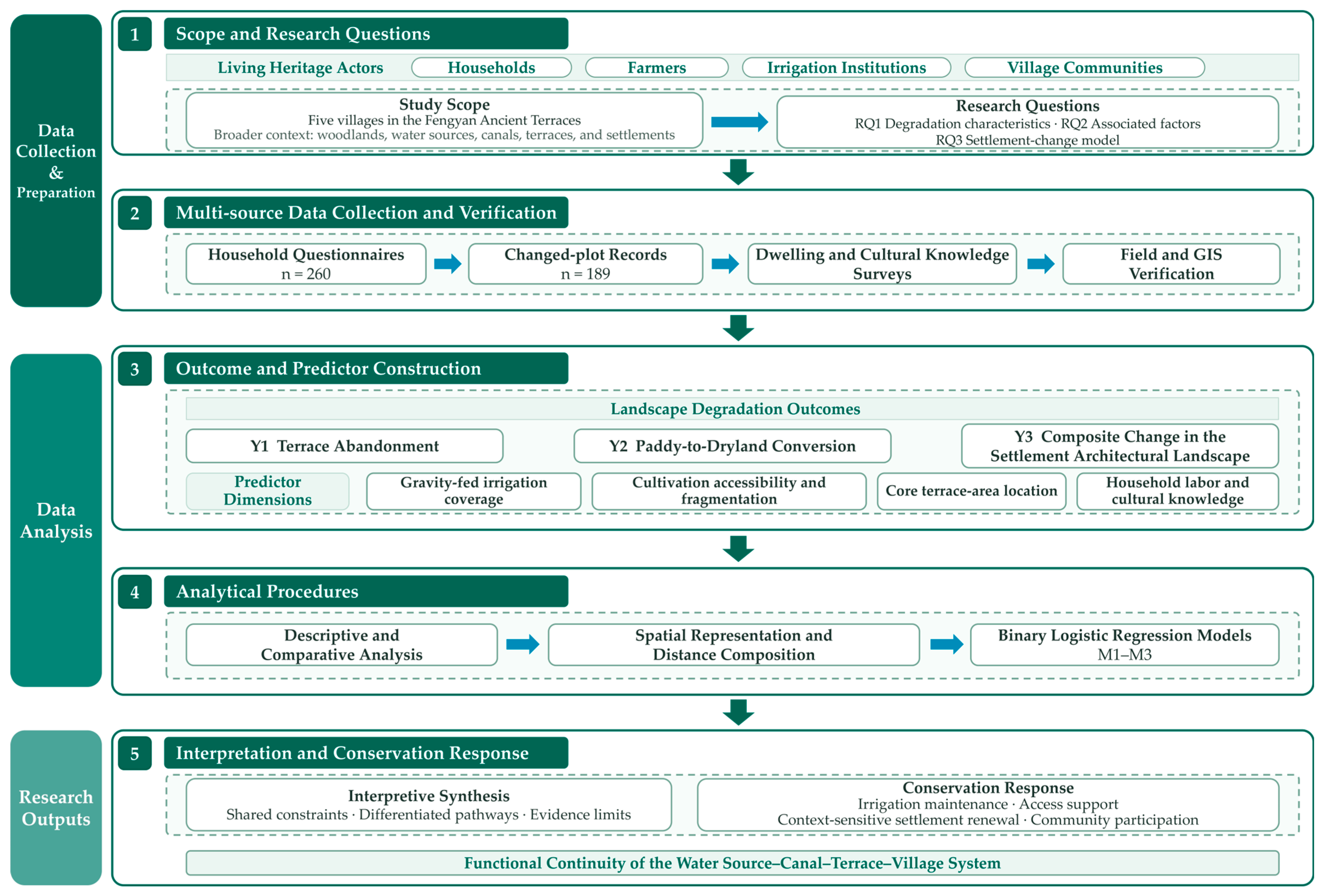
Figure 1 summarizes five stages: defining the scope and research questions; assembling household, plot, dwelling, and spatial data; operationalizing the three outcomes and their explanatory variables; conducting descriptive, comparative, spatial, and regression analyses; and interpreting the differentiated pathways for conservation planning. The figure is intended to communicate the research logic, whereas the questionnaire workflow, field procedures, variable definitions, and statistical decisions are detailed in
Section 2.3,
Section 2.4 and
Section 2.5. Terrace abandonment, conversion of paddy terraces to dryland, and composite change in the settlement architectural landscape are analyzed separately because they occur at different behavioral thresholds and spatial scales.
The workflow proceeded from field reconnaissance and questionnaire administration to anonymous linkage of household questionnaires, changed-plot records, dwelling observations, and spatial verification. Operational rules were then applied to classify Y1, Y2, and Y3 and to construct the explanatory variables. Descriptive statistics characterized the sample and outcome prevalence; between-village and core-area comparisons examined spatial heterogeneity; changed-plot records were summarized by distance bands; and separate binary logistic models evaluated conditional associations for the three outcomes. The final synthesis compared shared constraints and differentiated pathways and translated only the supported findings into recommendations for irrigation-network maintenance, terrace access, and settlement renewal. Terrace abandonment and dryland conversion primarily indicate changes in productive continuity, whereas the composite settlement indicator screens changes in physical fabric and landscape character. The detailed classification rules are presented in
Section 2.4.
2.2. Study Area
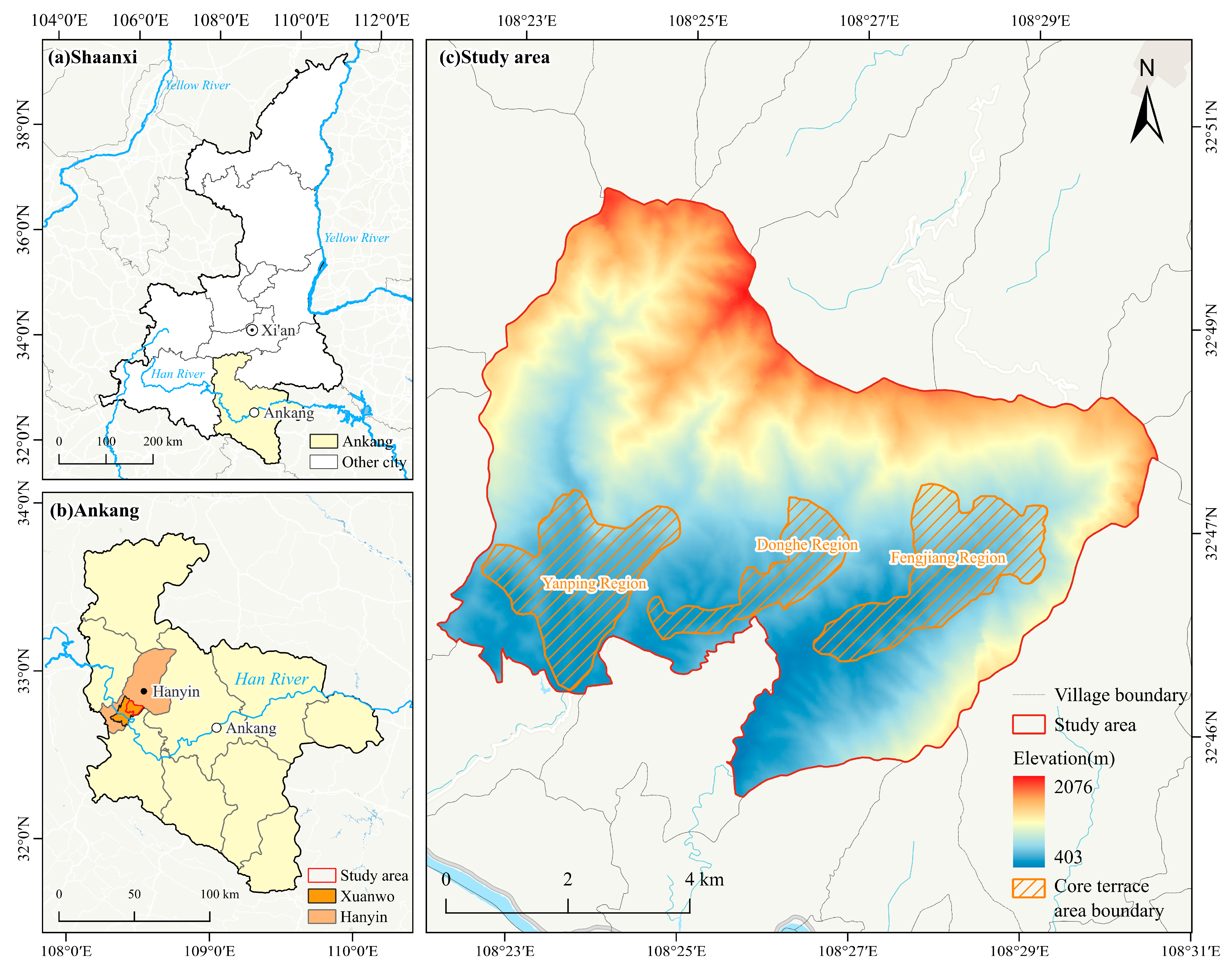
This study selected five villages—Cigou, Yanping, Donghe, Zhongyin, and Huanglong—within the core scenic area of the Fengyan Ancient Terraces as representative study sites. The study area (108.38–108.50° E, 32.75–32.84° N) is located on the southern slope of Fenghuang Mountain in Xuanwo Town, Hanyin County, Ankang City, Shaanxi Province. It lies in a transition zone of low mountains and hills between the Qinba Mountains and the Han River Valley (
Figure 2). Publicly available information reports a scenic-area extent of approximately 38.78 km
2 [
41]; this figure describes only the broader geographic setting and does not represent the boundaries of the five-village questionnaire sample or the three core terrace areas. The regional topography is shaped jointly by the Qinling Mountains, Fenghuang Mountain, the Daba Mountains, and the Han and Yue river valleys, producing an alternating pattern of mountains, hills, and valleys. The Fengyan Ancient Terraces are distributed mainly across gentle slopes and valleys on the northern bank of the Han River at elevations of approximately 400–850 m. Terrace surfaces extend along contour lines and downslope; together, stepped fields, bunds, canals, ponds, and settlements form a mountainous agricultural landscape adapted closely to the terrain [
36].
Traditional irrigation in the area is predominantly gravity-fed. In this study, gravity-fed irrigation denotes the conveyance of water from upstream springs, streams, diversion structures, ponds, or small reservoirs through elevation-driven channels to terraced fields without mechanical pumping at the plot. Actual water availability can vary with seasonal rainfall, spring and stream discharge, the condition of weirs and canals, storage capacity, and collective maintenance. The study did not measure discharge or seasonal delivery reliability directly; X1 therefore represents the household-level spatial coverage of the existing gravity-fed network rather than a complete hydrological or institutional assessment. The boundaries of the three core terrace areas—Yanping, Donghe, and Fengjiang—follow those delineated in a previous conservation and utilization study [
40]. These boundaries were established through field investigations and repeated consultation among the local government, relevant village committees, and planning experts, and cover a total area of 1014.88 ha. Local water-conservancy records [
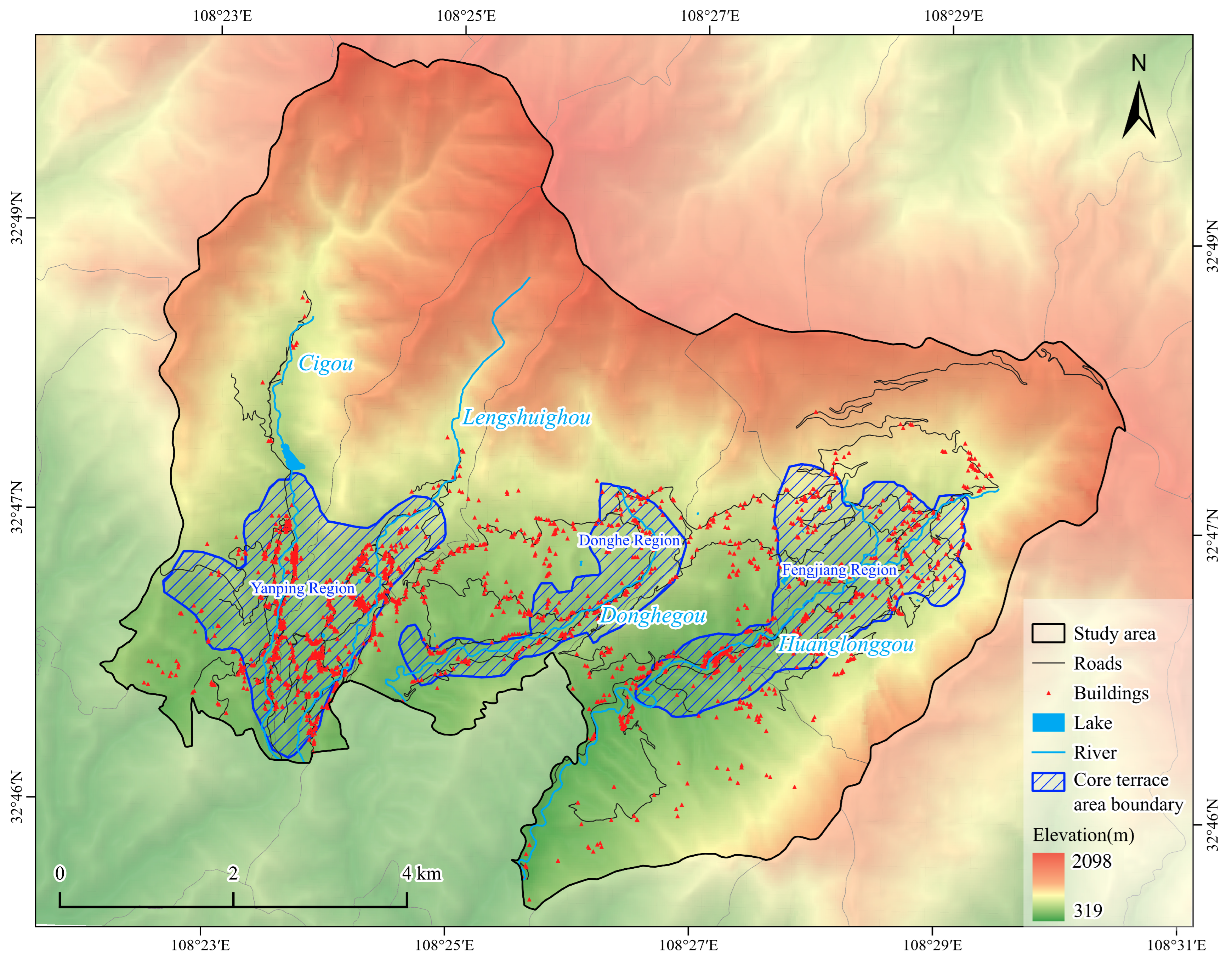
42] were used to cross-check place names and overall spatial relationships; no new boundary delineation was undertaken. The three terrace areas are distributed along the principal valley watercourses, and their names and spatial organization reflect how the water system structures the terraces, irrigation facilities, and settlement layout (
Figure 3). Long-term rice cultivation, hydraulic construction, and cultural interaction have created a living agricultural heritage system centered on terraces, supported by villages and irrigation facilities, and enriched by agricultural knowledge and migrant culture [
35,
38,
39,
40].
The Fengyan Ancient Terraces are recognized as both a Major Historical and Cultural Site Protected at the National Level and a Nationally Important Agricultural Heritage System of China; their irrigation system is also listed by the International Commission on Irrigation and Drainage as a World Heritage Irrigation Structure under the official name “Fengyan Terraces” [
32,
33,
34]. Management must therefore address multiple objectives, including conservation of protected heritage fabric, continuity of agricultural production, maintenance of hydraulic works, compatibility of settlement character, and improvement of community living conditions. These overlapping designations make the area a representative setting for research on human–environment relationships and living heritage conservation.
2.3. Data Sources and Survey Design
The study combined household questionnaires, plot-level records, dwelling observations, and spatial data, with the household serving as the basic unit of both the questionnaire survey and regression analysis. A household was operationally defined as the family-based unit that jointly managed contracted farmland and used a current or primary dwelling; one questionnaire represented one household and was linked to its plot and dwelling records through an anonymous identifier. Respondents were selected in the following order of priority: the household head; if the household head was unavailable, the primary farm worker; and, if neither was available, another adult familiar with the household’s agricultural production and land use. The questionnaire covered household population and labor, terrace use, dwellings and changes in the settlement architectural landscape, cultural knowledge, participation in tourism-related activities, and willingness to support conservation. All questionnaires were administered face-to-face using the same questionnaire, variable definitions, and respondent-priority rule. These procedures, together with plot-by-plot recording and field and spatial cross-checks, improved consistency across villages, although recall and interviewer effects cannot be excluded.
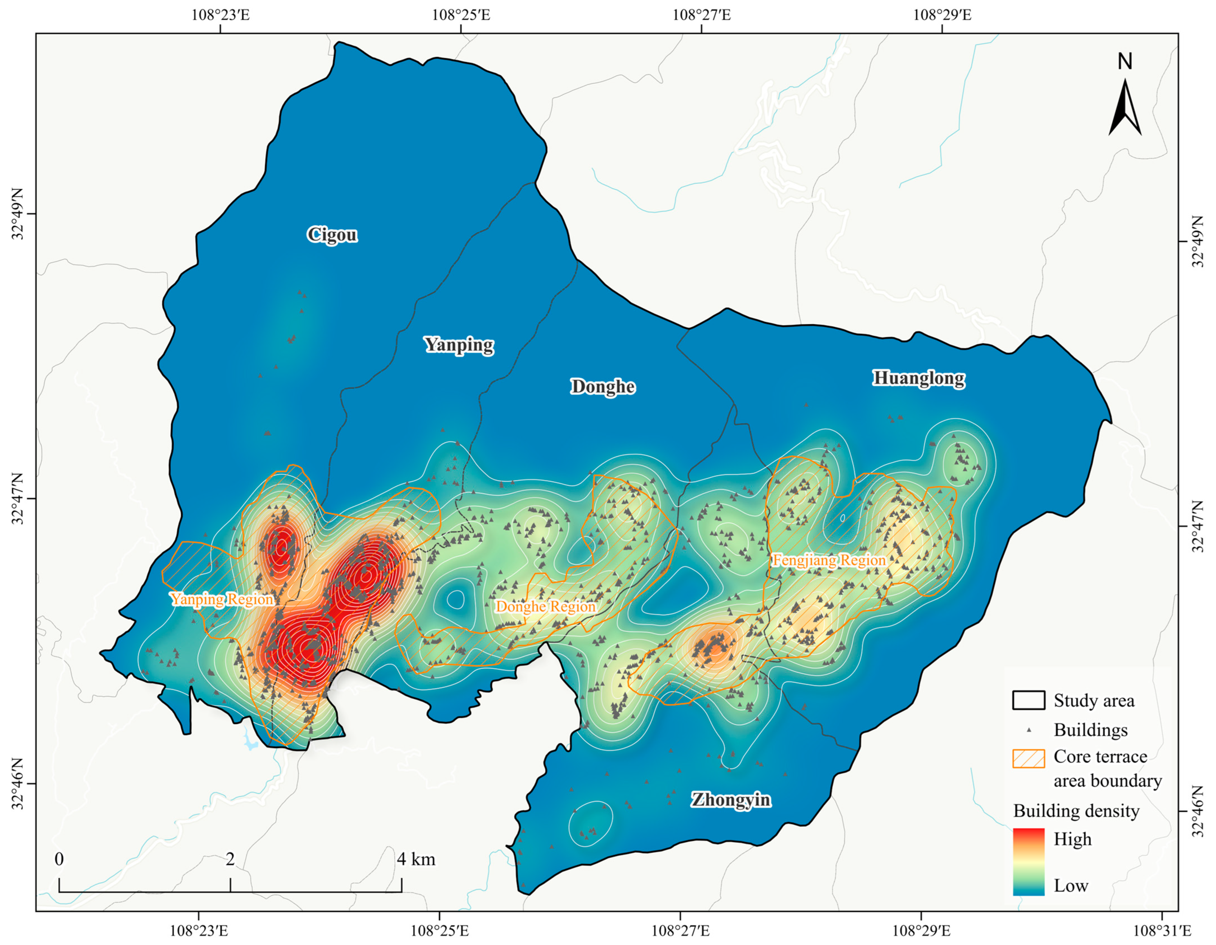
Field reconnaissance, household questionnaire surveys, and semi-structured interviews were conducted from late April to July 2026 in Cigou, Yanping, Donghe, Zhongyin, and Huanglong villages. Together, the five villages contained approximately 2637 households and 9362 residents. A map-guided, non-probability village-quota design was used. Village quotas approximated proportional allocation and yielded a total target of 260 households (approximately 9.86% of all households). Within each village quota, surveyors used maps to distribute visits across residential clusters and independently recruited households through door-to-door visits until the target was reached. The numbers surveyed in the five villages were 50, 50, 55, 50, and 55, respectively, yielding 260 valid questionnaires. This design sought coverage of different irrigation units, cultivation distances, cultivation locations, settlement forms, and degrees of tourism utilization; because households were not selected from a probability-based sampling frame, the sample should not be interpreted as statistically representative of the full five-village population. Spatial verification showed that the administrative areas of the five villages collectively cover the three core terrace areas; however, a village’s location within the core scenic area does not mean that every household cultivates terraces within a core terrace boundary. Cultivation location was therefore verified household by household. Village, terrace-area, and irrigation-unit names were used only for spatial description and not as the basis for classification. Although Huanglong Village has been administratively incorporated into Tianfeng Village, it is referred to here as ‘Huanglong Village (now part of Tianfeng Village)’ to maintain consistency with the heritage-area name, questionnaire codes, and GIS data. The distribution of village buildings and core terrace areas is shown in
Figure 4.
The 30 m digital elevation model (DEM) used for spatial representation was obtained from the SRTM V3 dataset [
43]. The DEM was used solely to visualize regional topography and was not used to derive explanatory variables or conduct terrain-based statistical analyses. The high-resolution satellite basemap was sourced from Tianditu, China’s National Platform for Common Geospatial Information Services, using imagery from 2025 [
44]. Road and watercourse data were based on OpenStreetMap (OSM) data [
45] and corrected with reference to satellite imagery. Settlement and building data were manually digitized from satellite imagery. All layers were projected to a common coordinate system, clipped, and overlaid in ArcGIS 10.8 (Esri, Redlands, CA, USA).
Terrace abandonment and dryland conversion were recorded plot by plot during the survey and linked to questionnaires using anonymous identifiers. This process produced 189 records of changed plots, which were used to calculate household-level variables and analyze the distance composition of the identified changes. Plot type and metric distances to water sources and settlements were taken directly from the anonymized plot-level survey records. Satellite imagery and GIS were used only to verify and locate plots, display distance groups, and prepare maps. They were not used to reclassify plot types, recalculate distances, or conduct an independent multitemporal remote-sensing change analysis. These metric distances are distinct from the walking times to the nearest and farthest cultivated plots reported in the household questionnaires. Because the total terrace area within each distance band was not recorded concurrently, the results indicate only how the area of each type of changed plot was distributed among distance bands; they do not represent band-specific degradation rates or risks.
The dwelling survey focused on each respondent household’s current or primary residence and recorded structural and functional characteristics, materials and architectural form, compatibility with the surrounding landscape character, and vacancy or physical deterioration. Functional conversion alone did not trigger classification as a composite change in the settlement architectural landscape; it was used only to distinguish adaptive reuse from incompatible renewal. Cultural knowledge was measured using ordinal scales assessing respondents’ understanding of Fengyan history, traditional irrigation-channel institutions, and migrant farming culture. Participation in tourism-related activities, willingness to restore terraces, and willingness to repair traditional dwellings were used only descriptively and were not included in the core regression models.
2.4. Operational Definitions of Degradation and Variable Construction
Terrace abandonment was defined as a formerly rice-producing terrace that was neither cultivated nor planted with another crop during the rice-growing season covered by the survey. If a household had at least one verified abandoned plot, Y1 = 1; otherwise, Y1 = 0. This variable captures land-use status at the time of the survey and does not imply permanent abandonment. Dryland conversion was defined as the cultivation of dryland crops, such as maize, sweet potato, beans, or vegetables, on a former paddy terrace during the rice-growing season. If a household had at least one verified converted plot, Y2 = 1; otherwise, Y2 = 0. The customary rice–rapeseed rotation, in which rapeseed is planted after the rice harvest and rice cultivation resumes in the following rice season, was not classified as dryland conversion, thereby avoiding misclassification of seasonal rotation. Y2 records observed land-use status only: the questionnaire did not collect plot-specific motives for conversion and therefore cannot distinguish water constraints from economic crop choice, labor saving, household consumption, or risk-management strategies. Composite change in the settlement architectural landscape (Y3) was determined from building structure, materials, form, compatibility with the surrounding character, and maintenance condition. Building function was recorded descriptively but did not independently trigger Y3. Accordingly, Y3 should not be interpreted simply as the rate of physical building deterioration.
Variable selection followed household-level approaches used in studies of agricultural heritage landscape degradation [
19,
20] and was organized around irrigation conditions, access to cultivated land, land operation, household labor, and cultural knowledge (
Table 1). X1 was constructed plot by plot. For each contracted plot, the respondent reported whether its area could receive water through the existing gravity-fed irrigation network and provided the corresponding area. These reports were cross-checked through field observation and GIS verification of plot location and spatial relationships. The gravity-fed area reported across all contracted plots was summed and divided by the household’s total contracted farmland area. Field and GIS checks supported spatial verification but did not measure discharge, seasonal water availability, delivery reliability, or irrigation governance. X1–X4 represent material and spatial costs related to terrace maintenance. A larger share of land served by gravity-fed irrigation may support continued paddy cultivation; longer cultivation distances increase time and physical effort; and a larger number of plots per unit of contracted farmland indicates greater fragmentation and may raise the cost of maintaining bunds and canals. X5 denotes the location of a household’s cultivated terraces relative to the boundaries of the three core terrace areas. No sampled household cultivated land across these boundaries: X5 = 1 when all terraces cultivated by a household were within the core areas and X5 = 0 when all were outside. The corresponding sample sizes were 202 and 58 households, and X5 was included as an explanatory variable in M1 and M2. X6–X10 describe the allocation of household labor between agriculture and off-farm employment, whereas X11 measures knowledge of Fengyan history, irrigation institutions, and migrant farming culture. Both M1 and M2 included X1–X7 to compare the associations of the same resource, spatial, and labor conditions with abandonment and dryland conversion. M3 included X8–X11 to explore associations between labor mobility and cultural knowledge and composite change in the settlement architectural landscape.
2.5. Statistical Analysis
Descriptive statistics were used to summarize household characteristics, land operation, and manifestations of landscape degradation. Continuous variables were reported as means and standard deviations [mean (SD)], and categorical variables as frequencies and percentages [n (%)]. Differences in continuous variables among the five villages were assessed using the Kruskal–Wallis H test, whereas categorical variables were compared using Pearson’s chi-square test. For comparisons grouped by X5, the Mann–Whitney U test was applied to X1–X4 and X6–X11, and Pearson’s chi-square test was applied to Y1–Y3. All tests were two-sided, and p < 0.05 was considered statistically significant.
Separate binary logistic regression models were fitted for terrace abandonment (Y1), dryland conversion (Y2), and composite change in the settlement architectural landscape (Y3). The model was specified as shown in Equation (1):
M1 used Y1 as the dependent variable, and M2 used Y2; both models included X1–X7. M3 used Y3 as the dependent variable and included X8–X11. For X5, households cultivating outside the core terrace areas (X5 = 0) served as the reference category. The models report p-values, odds ratios (ORs), and 95% confidence intervals (CIs). An OR > 1 indicates a positive association, whereas an OR < 1 indicates a negative association. Variance inflation factors (VIFs) were used to assess multicollinearity, and likelihood-ratio tests were used to evaluate overall model significance. Regression results were interpreted only as conditional associations within the sample and not as evidence of strict causal effects.
Data organization and derived-variable calculations were performed in Microsoft Excel 2016 (Microsoft Corporation, Redmond, WA, USA); statistical analyses were conducted in IBM SPSS Statistics 26 (IBM Corp., Armonk, NY, USA); and spatial-data processing and cartography were completed in ArcGIS 10.8.
3. Results
3.1. Sample Characteristics and Overall Landscape Degradation
The analysis included 260 valid household questionnaires from Cigou, Yanping, Donghe, Zhongyin, and Huanglong villages. Mean (SD) household size and household labor force were 5.27 (1.99) and 3.22 (1.48) persons, respectively. The corresponding numbers of household members farming at home and working away from home were 1.83 (1.04) and 1.35 (1.10). Migrant workers accounted for an average of 25.75% of the total household population and 38.80% of the household labor force, reflecting both continued dependence on local labor for terrace cultivation and the extension of household livelihoods into non-agricultural activities.
The mean (SD) age of the primary farm worker was 63.52 (8.83) years, with a median of 64 years and an interquartile range of 57.75–69.00 years. Primary farm work was undertaken by men in 136 households (52.31%), by women in 99 households (38.08%), and jointly by men and women in 25 households (9.62%). These figures reflect the advanced age of primary farm workers and the limited local labor supply within the sample.
The mean (SD) contracted farmland area, number of plots, and land fragmentation were 4.91 (2.12) mu, 5.50 (2.67) plots, and 1.16 (0.45) plots per mu, respectively. The area served by gravity-fed irrigation and its share of contracted farmland averaged 3.11 (1.78) mu and 63.02% (20.50 percentage points), respectively. Mean (SD) walking times from the dwelling to the nearest and farthest cultivated plots were 10.62 (6.81) min and 41.94 (16.38) min, with medians of 10 and 41 min, respectively. X5 = 1 for 202 households (77.69%) and X5 = 0 for 58 households (22.31%). Together, these indicators characterize household irrigation conditions, plot dispersion, cultivation radius, and cultivation location (
Table 2).
The three manifestations of landscape degradation differed in prevalence and form. Of the 260 households, 77 experienced terrace abandonment (29.62%), 65 experienced dryland conversion (25.00%), and 118 experienced at least one of these forms of production landscape degradation (45.38%). Abandonment alone occurred in 53 households (20.38%), dryland conversion alone in 41 households (15.77%), and both in 24 households (9.23%). Thus, the two outcomes overlapped but represented distinct land-use responses. Among the 189 records of changed plots, 111 abandonment records covered 54.5 mu and 78 dryland-conversion records covered 33.0 mu. These areas were used only to analyze distance composition and do not represent the total area of degraded plots in the five villages. In the settlements, 198 households (76.15%) exhibited a composite change in the settlement architectural landscape. This indicator integrates structure, materials, form, compatibility with the surrounding landscape character, and maintenance condition, and is not equivalent to the rate of physical building deterioration.
3.2. Between-Village Differences and Comparisons by Cultivation Location
Village-level profiles showed marked heterogeneity in irrigation coverage. Mean shares of farmland under gravity-fed irrigation were 70.59% in Cigou, 69.72% in Donghe, 61.74% in Zhongyin, 59.22% in Huanglong, and 53.54% in Yanping, and the overall distribution differed significantly among the five villages (p < 0.001). The age of the primary farm worker (p = 0.023) and walking time to the nearest cultivated plot (p = 0.003) also differed among villages, whereas walking time to the farthest cultivated plot did not (p = 0.254). Because no post hoc pairwise comparisons were conducted, these tests establish only overall heterogeneity and do not identify statistically distinct village pairs.
The prevalence profiles also differed by outcome. Yanping combined the lowest mean gravity-fed irrigation share with the highest abandonment prevalence (48.00%) and the highest prevalence of either abandonment or dryland conversion (64.00%). Abandonment prevalence was 22.00% in Cigou, 30.91% in Donghe, 22.00% in Zhongyin, and 25.45% in Huanglong. Dryland conversion ranged from 20.00% to 32.00%, and composite settlement change ranged from 69.09% to 82.00%; neither outcome differed significantly among villages. The overall difference for abandonment was significant (
p = 0.023), whereas that for either production outcome approached but did not reach the 0.05 threshold (
p = 0.064) (
Table 3). These values provide localized descriptive profiles, not village-specific estimates of causal effects. Separate village regressions were not fitted because the village samples of 50–55 households and the smaller outcome counts would yield unstable estimates.
Household-level verification showed that all terraces cultivated by 202 households (77.69%) were within the core terrace areas, whereas all terraces cultivated by 58 households (22.31%) were outside; no household in the sample cultivated across these boundaries. The numbers of households with X5 = 1/X5 = 0 in Cigou, Yanping, Donghe, Zhongyin, and Huanglong were 42/8, 32/18, 43/12, 41/9, and 44/11, respectively, demonstrating within-village variation in cultivation location relative to the core terrace areas. The proportions of abandonment, dryland conversion, and composite change in the settlement architectural landscape did not differ significantly between the two groups. Comparisons of X1–X4 and X6–X11 likewise showed no significant group differences. These results describe unadjusted between-group differences within the sample and should not be interpreted as causal effects of the conservation boundary.
3.3. Spatial Distance Composition of Changed Terrace Plots
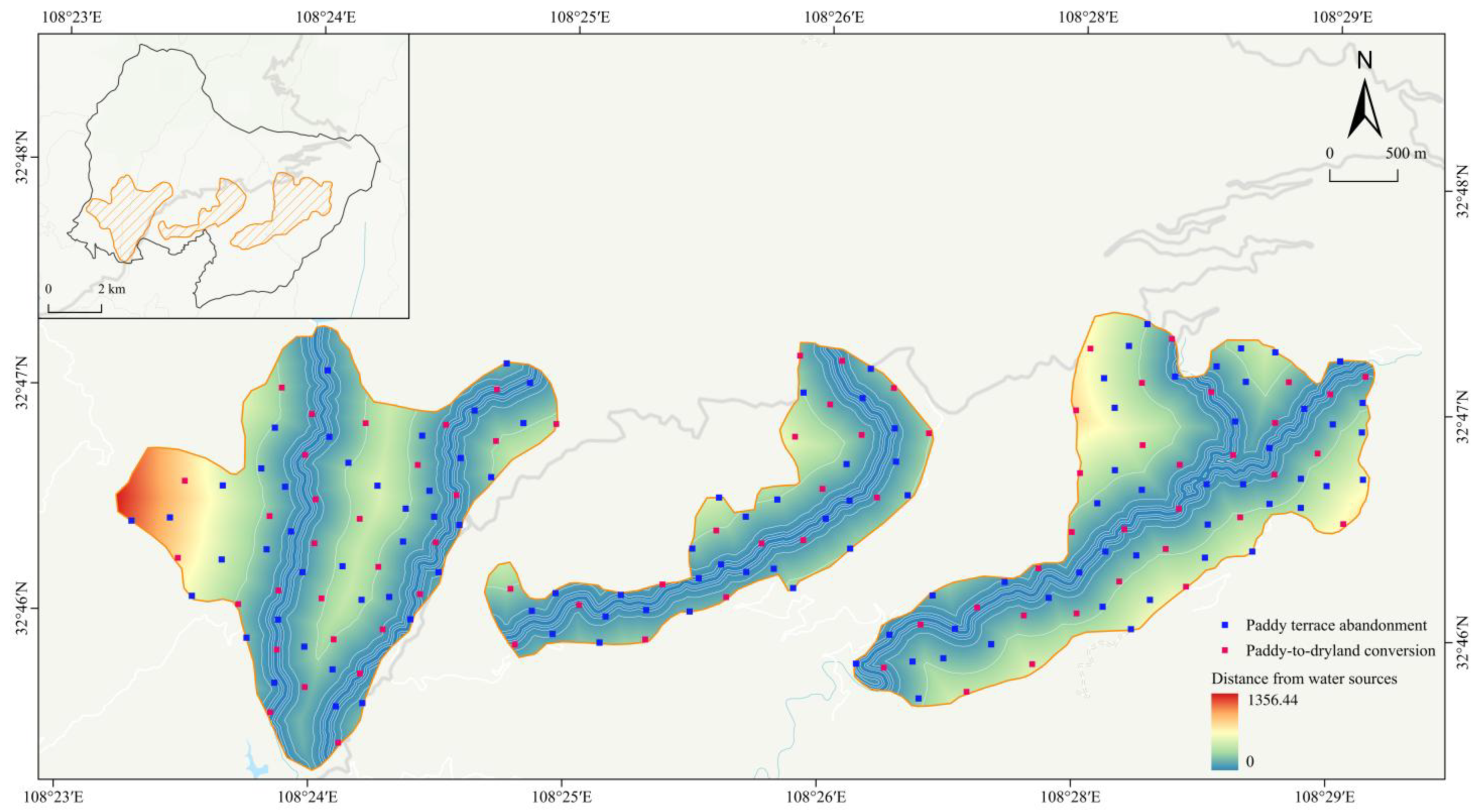
Using the total area of each type of changed plot as the denominator, 41.28% and 22.75% of the abandoned area occurred in the (100, 300] m and >300 m zones from water sources, respectively, for a combined share of 63.68% beyond 100 m. The (50, 100] m zone accounted for 15.78%, while zones within 50 m accounted for 20.18%. For dryland-converted area, the (100, 300] m and >300 m zones accounted for 39.09% and 18.48%, respectively, totaling 57.58% beyond 100 m; the (50, 100] m zone accounted for 23.03%, and zones within 50 m accounted for 19.39%. Larger shares of both types of changed-plot area occurred beyond 100 m from water sources, with a greater concentration of abandoned area (
Table 4).
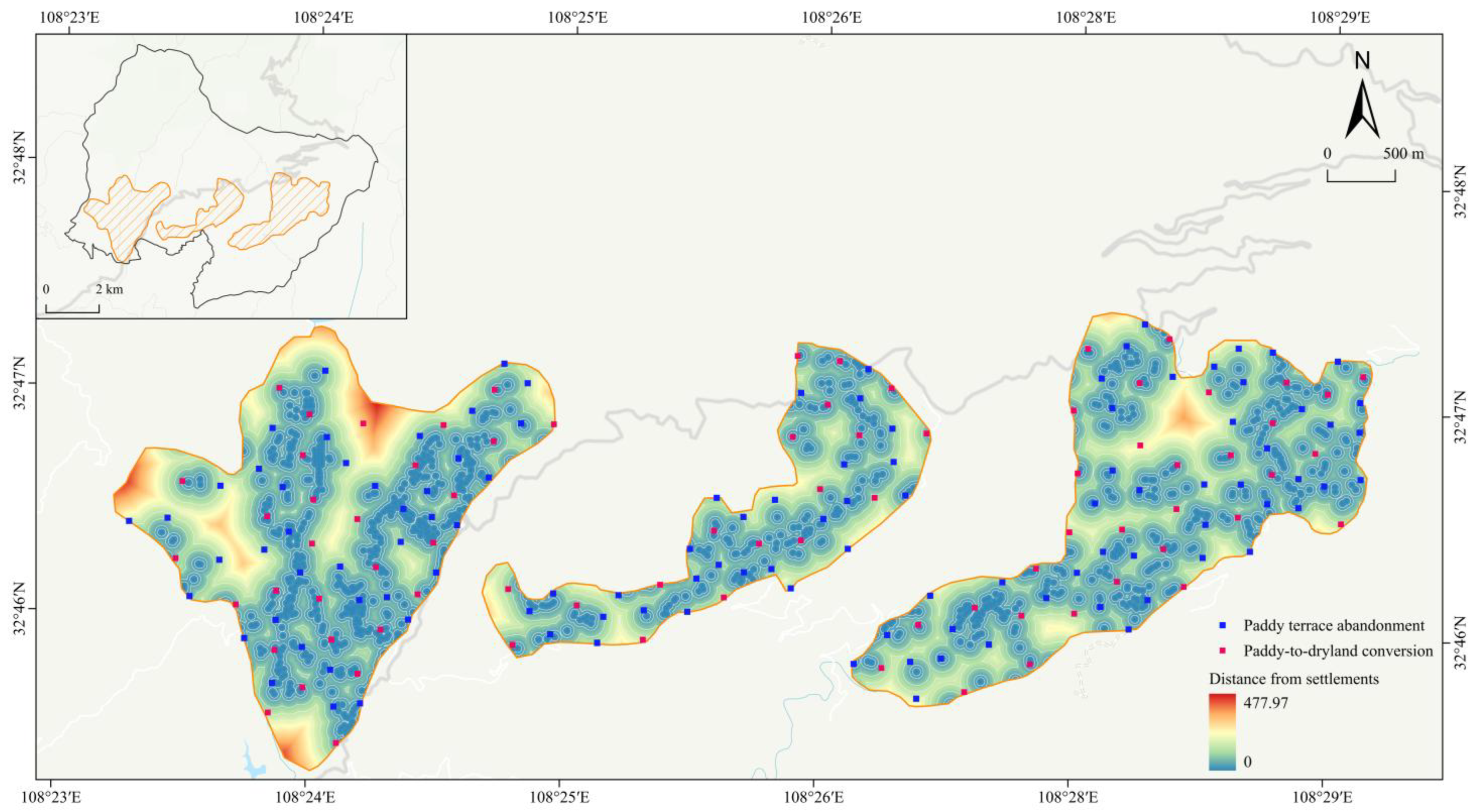
With respect to distance from settlements, the (50, 100] m, (30, 50] m, [0, 30] m, and (100, 150] m zones accounted for 37.43%, 24.22%, 18.72%, and 17.06% of the abandoned area, respectively. A total of 80.37% was within 100 m, while 2.57% was beyond 150 m; no abandoned area was recorded beyond 200 m. Dryland-converted area peaked in the [0, 30] m zone (46.67%), while the (50, 100] m, (100, 150] m, and (30, 50] m zones accounted for 19.70%, 16.97%, and 10.00%, respectively. In total, 76.36% was within 100 m and 6.67% was beyond 150 m.
Considering both distance measures (
Figure 5 and
Figure 6), the area of both types of changed plot was concentrated mainly beyond 100 m from water sources and within 100 m of settlements. The largest share of dryland-converted area occurred in the [0, 30] m zone from settlements, whereas the largest share of abandoned area occurred in the (50, 100] m zone. The plots shown in the figures are the 189 changed-plot records identified through household surveys and field verification; they do not represent remote-sensing identification or a complete spatial census of all terraces in the study area. Because the total terrace area in each distance zone was unavailable, these percentages describe only the area composition of the identified changed plots. They do not represent zone-specific degradation rates or risks and are insufficient to establish a distance gradient.
3.4. Indicators of Settlement Architectural Landscape Degradation and Cultural Knowledge
Among the primary dwellings of the 260 households, 108 (41.54%) were classified as modern replacement structures. Traditional materials and structures were fully retained, partially retained, and not retained in 81 (31.15%), 39 (15.00%), and 140 dwellings (53.85%), respectively. Traditional pitched roofs or principal architectural forms were fully retained in 57 dwellings (21.92%), partially retained in 81 (31.15%), and not retained in 122 (46.92%). Modern building materials were used in 142 dwellings (54.62%).
A total of 57 dwellings (21.92%) were compatible with the surrounding traditional landscape character, 118 (45.38%) were moderately compatible, and 85 (32.69%) were incompatible. Based on the combined assessment of building structure, materials, form, compatibility with the surrounding character, and maintenance condition, 198 households (76.15%) exhibited a composite change in the settlement architectural landscape. Only 31 dwellings (11.92%) had records of evident vacancy or physical deterioration.
Mean (SD) scores for respondents’ knowledge of the historical origins of Fengyan, traditional irrigation-channel institutions, and migrant farming culture were 3.15 (1.09), 3.07 (1.09), and 3.16 (0.99), respectively. The numbers scoring at levels 4–5 were 107 (41.15%), 92 (35.38%), and 98 (37.69%), respectively. X11, calculated as the mean of the three knowledge items, was 3.13 (0.67). Its internal consistency was low (Cronbach’s alpha = 0.258), so it was included in M3 only as an exploratory variable. In addition, 117 households (45.00%) participated in tourism businesses or related activities (
Table 5).
Overall, degradation of the settlement architectural landscape was reflected more in the loss of traditional materials, architectural forms, and compatibility with the overall landscape character than in widespread dwelling vacancy or physical deterioration. Although the prevalence of composite change in the settlement architectural landscape was 76.15%, only 11.92% of dwellings showed evident vacancy or physical deterioration. Thus, Y3 served primarily as a screening indicator for changes in the physical fabric of settlements and their potential effects on landscape character. Because some structural and material upgrades may improve living conditions, Y3 should be understood as a composite screening indicator of landscape degradation; not every dwelling that triggers Y3 can be classified directly as an incompatible intervention or as physically deteriorated.
3.5. Factors Associated with Landscape Degradation
The overall M1 model for abandonment and M2 model for dryland conversion were statistically significant (p < 0.001 and p = 0.007, respectively), whereas the overall M3 model for composite change in the settlement architectural landscape was not (p = 0.748). All assessed variance inflation factors were below 5, indicating no evident multicollinearity.
After adjustment for the other variables, the share of farmland under gravity-fed irrigation (X1) was significantly and negatively associated with abandonment in M1 (OR = 0.194, 95% CI: 0.048–0.775, p = 0.020). A 10-percentage-point increase in this share was associated with approximately 15.2% lower odds of abandonment. Walking time to the farthest cultivated plot (X3) was significantly and positively associated with abandonment (OR = 1.039, 95% CI: 1.018–1.059, p < 0.001). Each 1-min increase was associated with approximately 3.9% higher odds; for a 10-min increase, the odds of abandonment were approximately 1.46 times as high. Cultivation location relative to the core terrace areas (X5) was not significantly associated with abandonment (p = 0.904), and none of the other variables reached the 0.05 significance level.
In M2, the share of farmland under gravity-fed irrigation (X1) was significantly and negatively associated with dryland conversion (OR = 0.085, 95% CI: 0.020–0.359,
p < 0.001). A 10-percentage-point increase in this share was associated with approximately 21.9% lower odds of dryland conversion. Cultivation location relative to the core terrace areas (X5) was not significantly associated with dryland conversion (
p = 0.464), and none of the other variables reached the 0.05 significance level (
Table 6).
The overall M3 model was not statistically significant. The number of migrant workers, annual duration of migrant work, migrant-worker share of the household labor force, and local cultural knowledge showed no stable associations. The available household-level measures of labor mobility and cultural knowledge were therefore insufficient to explain composite change in the settlement architectural landscape.
Overall, the three outcomes exhibited both shared constraints and differentiated pathways. The measured share of farmland covered by gravity-fed irrigation was associated with abandonment and dryland conversion, while walking time to the farthest cultivated plot was additionally associated with abandonment. Cultivation location inside or outside the core terrace boundaries showed no stable independent association. The non-significant coefficients are not interpreted as proof that the corresponding processes are unimportant; rather, they delimit what this cross-sectional household dataset can support after simultaneous adjustment. Changes in the settlement architectural landscape require further explanation in relation to property rights, household life cycles, residential needs, and modes of building renewal.
4. Discussion
4.1. Shared Constraints and Differentiated Pathways of Production Landscape Degradation
The most consistent model pattern was the negative association of X1 with both abandonment and dryland conversion. X1 measures the share of a household’s contracted farmland covered by the gravity-fed network; it does not directly measure the quantity, timing, or reliability of delivered water. Seasonal rainfall, spring and stream discharge, canal condition, storage capacity, and maintenance arrangements can therefore affect actual irrigation performance even where a plot is nominally served. The results show that greater network coverage was associated with lower odds of both outcomes, but they cannot isolate whether hydrological variability, infrastructure condition, or collective management generated that association. Walking time to the farthest cultivated plot was additionally associated with abandonment, consistent with recurrent costs of transporting inputs, repairing bunds, inspecting plots, and maintaining channels as the cultivation radius expands. Studies of mountainous terraces in the Mediterranean, the Alps, and China likewise identify accessibility, low returns, generational succession, and maintenance burdens as interacting constraints [
13,
14,
15,
16,
17,
18,
19,
20].
Dryland conversion requires a more cautious interpretation than abandonment. Conversion retains cultivation and may be an adaptive response to limited or uncertain water, but it may also reflect deliberate selection of crops with higher expected returns, lower labor or water requirements, household consumption value, better market access, or lower production risk. The survey classified the observed land-use outcome but did not measure plot-specific motives, crop prices, production costs, or net returns consistently. The negative association between X1 and dryland conversion is therefore compatible with an irrigation-related mechanism but does not establish that deterioration of the irrigation system caused households to convert paddy terraces. From the perspective of living rice-farming heritage, conversion still represents a reduction in traditional paddy function, yet it should not be equated with abandonment or treated as an involuntary response. The two outcomes are better understood as differentiated pathways whose relative importance depends on interacting hydrological, economic, labor, and household considerations.
4.2. Cultivation Location and Between-Village Heterogeneity in Landscape Degradation
All five surveyed villages are located within the core scenic area, but the terraces cultivated by sampled households occur both inside and outside the three core terrace areas. Because X5 measures only the location of a household’s cultivated terraces and does not represent the intensity or duration of conservation measures, the results cannot be used to infer that conservation in the core terrace areas has been ineffective. Neither the group comparisons nor the regression models identified a stable association between cultivation location relative to the core terrace areas and terrace abandonment or dryland conversion. Within this sample and under the controls included in the models, functional production conditions were therefore more closely associated with degradation of the terrace production landscape than boundary status alone.
The localized profiles add context to the pooled models. Cigou and Donghe had the highest mean irrigation coverage, while Yanping had the lowest coverage and the highest abandonment prevalence. Zhongyin and Huanglong occupied intermediate positions, and dryland conversion and composite settlement change varied less sharply across villages. These contrasts should not be read as village-level causal effects because the overall tests did not include post hoc comparisons and the sample was not large enough for stable village-specific regressions. They nevertheless identify where follow-up diagnosis should examine canal condition, spring and stream reliability, crop choices, maintenance organization, and household access in greater detail. Heritage designation or conservation boundaries cannot substitute for continuous monitoring of production, ecological processes, and community action [
3,
4,
5,
15]. Conservation should therefore address weak links within and outside the core terrace areas and avoid concentrating resources only in showcase zones.
4.3. Definitional Boundaries and Living Renewal of the Settlement Architectural Landscape
Composite change in the settlement architectural landscape affected 76.15% of households, whereas only 11.92% of dwellings showed evident vacancy or physical deterioration. The high prevalence of the composite indicator thus arose mainly from changes in structure, materials, roof form, and compatibility with the surrounding landscape character, and should not be interpreted as a rate of physical building deterioration. The overall M3 model was not statistically significant (p = 0.748), and the cultural-knowledge items had low internal consistency. The available indicators of labor mobility and cultural knowledge were therefore insufficient to provide a stable explanation of composite change in the settlement architectural landscape, and M3 should be regarded only as a supplementary exploratory model.
Degradation of the settlement landscape cannot be judged simply by whether materials are old or new. Instead, assessment should consider whether building renewal diminishes traditional material attributes, courtyard relationships, or the continuity of settlement interfaces. Within living agricultural heritage, dwellings are both components of the traditional landscape and spatial carriers of continued community life. International research regards community-led rehabilitation, place attachment, and improvements in residential performance as important components of sustaining living heritage [
28,
29,
30,
31]. Fengyan should therefore distinguish among disrepair and decay, incongruous renewal, and adaptive renewal. The first two should be addressed through repair inventories and landscape-character coordination measures, respectively, whereas the third should be guided by technical guidelines and design support. Low-intervention improvements should also meet contemporary needs for safety, sanitation, and residential comfort, thereby avoiding an approach that equates conservation with the static freezing of a historic appearance.
4.4. Pathways of Landscape Degradation and Implications for Living Heritage Conservation
The principal contribution of this study is not the number of statistically significant coefficients but the empirical separation of three processes that are often collapsed into a single degradation label. The models identify one shared correlate (gravity-fed irrigation coverage), one correlate specific to abandonment (distance to the farthest cultivated plot), no stable association with the core-area location indicator, and no supported explanatory model for composite settlement change. This pattern distinguishes cessation of cultivation, adaptive transformation of paddy use, and change in settlement fabric while making the evidential limits explicit. It supports a functional-continuity perspective in which water conveyance, access, household decisions, and settlement renewal are evaluated as connected but non-equivalent components of living heritage.
The broader Fengyan landscape also contains woodlands, water-source forests, springs, streams, canals, ponds, and small reservoirs. These components are essential to ecological and hydraulic continuity, but their degradation was not measured as a separate outcome in this study. Accordingly, the empirical claims are confined to the production and settlement dimensions represented by Y1–Y3, with irrigation coverage treated as an explanatory condition. Within that boundary, comparison is most appropriate with mountainous rice-terrace systems that rely on gravity-fed or community-managed irrigation, are farmed by smallholders, and face labor out-migration, including the Hani, Ziquejie, and Ifugao rice terraces and farmer-managed irrigation systems in Nepal [
20,
21,
22,
23,
24,
25,
26,
27]. Such comparisons inform mechanisms and research hypotheses; they do not imply that odds ratios or prevalence estimates are transferable. Comparisons with Mediterranean and Alpine dryland terraces should be limited to shared issues such as accessibility, maintenance labor, generational succession, production–settlement linkages, and participatory management [
13,
14,
15,
16].
Planning for Fengyan should therefore shift from the restoration of individual elements and visual display toward integrated maintenance of production processes, hydraulic networks, and settlement life. Whether a plot lies inside or outside the core terrace boundaries should not be the sole basis for allocating resources. Inspection and maintenance inventories should cover the full continuum from water sources through main and branch canals to field ditches. Depending on distance-related cultivation costs and irrigation constraints, interventions may include access improvements, collective maintenance, outsourced cultivation services, or ecological fallowing. Differentiated guidelines should also coordinate residential improvements with the conservation of key landscape-character elements.
4.5. Limitations and Future Research
This study is limited by its cross-sectional design, non-probability village quotas, and the range and resolution of the available variables. X1 records the share of farmland covered by gravity-fed conveyance but not rainfall, spring or stream discharge, seasonal delivery reliability, water-allocation rules, or canal condition. The survey did not consistently measure crop-specific prices, yields, labor inputs, net returns, market access, or household motives for dryland conversion; economic and risk-management explanations therefore remain plausible alternatives to an irrigation-centered interpretation. The outcome framework measured production and settlement dimensions but did not quantify degradation of woodlands, water-source forests, streams, canals, ponds, or other ecological components. The distance analysis covered only the 189 identified changed-plot records and lacked total terrace-area denominators for calculating rates by distance zone. Although M1 and M2 were significant overall, M3 lacked statistical support, and the village samples were insufficient for stable village-specific models. Future research should combine hydrological monitoring, crop-budget and decision data, complete plot inventories, repeated household surveys, multitemporal spatial data, and architectural assessment. Longitudinal or multilevel designs are also needed to distinguish household decisions from village context, conservation measures, and collective irrigation governance.
5. Conclusions
Drawing on 260 household questionnaires from Cigou, Yanping, Donghe, Zhongyin, and Huanglong villages, 189 changed-plot records, and surveys of settlement architecture and cultural knowledge, this study compared terrace abandonment, dryland conversion, and composite change in the settlement architectural landscape at household, plot, and village scales. Its contribution is an operational distinction among cessation of cultivation, transformation of paddy function, and settlement change within a functional production-irrigation-settlement framework. The analysis addresses these measured dimensions rather than claiming a comprehensive assessment of all ecological components of the rice-terrace landscape. The main conclusions are as follows.
- (1)
Landscape degradation in the Fengyan Ancient Terraces involves the coexistence of multiple processes. Among the 260 sampled households, 77 experienced terrace abandonment (29.62%), 65 experienced dryland conversion (25.00%), and 118 experienced at least one of these forms of production landscape degradation (45.38%). Composite change in the settlement architectural landscape affected 198 households (76.15%), but only 31 dwellings (11.92%) showed evident vacancy or physical deterioration. Abandonment, dryland conversion, and architectural landscape change have distinct analytical meanings and should not be combined into a single degradation index.
- (2)
Terrace abandonment and dryland conversion shared one measured correlate but followed differentiated pathways. A higher share of farmland covered by gravity-fed irrigation was associated with lower odds of both outcomes, while longer walking time to the farthest cultivated plot was associated with higher odds of abandonment. X1 is a coverage indicator rather than a direct measure of rainfall, spring discharge, delivery reliability, or canal governance. Moreover, dryland conversion may reflect water constraints, economic crop choice, labor saving, household consumption, or risk management. The cross-sectional models therefore do not establish that irrigation deterioration caused conversion.
- (3)
Landscape degradation exhibits spatial heterogeneity among villages and at the plot scale. All terraces cultivated by 202 households were located within the core terrace areas, whereas all terraces cultivated by the other 58 households were outside. Both household groups were represented in all five villages, and no household cultivated across these boundaries. Cultivation location relative to the core terrace areas did not show a stable association with any of the three manifestations of landscape degradation, but this does not imply that conservation management was ineffective. Abandonment prevalence differed significantly among villages and was highest in Yanping. The identified abandoned and dryland-converted plots were concentrated mainly more than 100 m from water sources and within 100 m of settlements. These percentages describe only the area composition of the changed plots and do not represent zone-specific degradation rates or risks.
- (4)
Degradation of the settlement architectural landscape requires differentiation among physical deterioration, incongruous renewal, and adaptive renewal. The available variables on labor mobility and cultural knowledge were insufficient to provide a stable explanation of composite change in the architectural landscape and should therefore not be treated as established associated factors. Further research should examine housing property rights, building age, household life cycles, permanent occupancy, road accessibility, and renewal needs.
Based on these findings, living heritage conservation in the Fengyan Ancient Terraces should prioritize maintenance of functional links among water sources, canals, terraces, villages, and the people responsible for their use and upkeep. Because X1 captures network coverage rather than delivery reliability, interventions should be preceded by site-specific diagnosis of spring and stream conditions, canal integrity, allocation practices, and crop-choice motives. Access support should target distant plots where cultivation costs are high, while settlement renewal should distinguish disrepair, incongruous alteration, and adaptive improvement. The study’s operational framework shows why static boundary status alone is insufficient: conservation depends on continued production, hydraulic coordination, viable household decisions, and habitable settlements. The effects of the proposed interventions require longitudinal monitoring, and future assessments should incorporate the woodland, water-source, and canal components that were outside the measured outcome framework.