


Abstract
Biocultural diversity underpins the stability and adaptive capacity of rural cultural landscapes. Taking the Fengyan Terraced Fields in Hanyin County, Shaanxi Province, China, as a case study, this paper integrates landscape character identification, element coupling measurement, and the GeoDetector model to examine the multi-level coupling relationships of biocultural diversity from the perspectives of spatiotemporal differentiation and element interaction patterns. The results show that: (1) the Fengyan Terraced Fields comprise five landscape character zones with pronounced gradient differences, forming a nested spatial pattern characterized by “intensive adaptation at low elevations, balanced development at middle elevations, ecological conservation at high elevations, and clustered cultural features along elevational gradients”; (2) landscape evolution has undergone a staged process of “formation–stabilization–reorganization,” reflecting an adaptive transformation from a traditional farming system to a composite system integrating heritage conservation, ecological agriculture, and cultural display; and (3) ecological, production, and cultural elements generally exhibit synergistic rather than trade-off relationships, in which ecological and production factors are important structural correlates of system feedback intensity, while cultural factors, although not the sole dominant variables, show marked interaction enhancement effects with the ecological and production dimensions. The study concludes that the biocultural diversity of the Fengyan Terraced Fields is essentially a composite human–environment system formed through the long-term embedding of the natural environment, farming techniques, settlement organization, and cultural institutions. The findings inform the scientific conservation and sustainable use of mountainous rural cultural landscapes.
1. Introduction
Rural areas face the twin crises of ecological degradation and the loss of traditional culture amid globalization and modernization, with an increasingly evident decline in biocultural diversity [1]. The world has now entered the “Anthropocene,” a new era in which human activities have become the dominant driver of change within the Earth system, exceeding any other factor [2]; from certain perspectives, the influence of human activities on ecosystems even surpasses that of natural driving forces [3]. The complexity of human-nature interactions has become increasingly evident. Rural areas are now understood as complex territorial systems that retain evidence of the long-term co-evolution of human society and the natural environment [4] and integrate biodiversity and cultural diversity, rather than serving solely as spaces for agricultural production. Advancing the rural revitalization strategy is a major national development priority, with “ecologically livable” and “culturally civilized” rural areas being core requirements. However, in the process of rapid urbanization, many traditional villages with a long farming history and distinctive regional features are facing the risks of landscape fragmentation and the disruption of local knowledge transmission. Therefore, an in-depth analysis of the coupling and interaction patterns between natural and cultural elements in rural areas is not only a scientific response to global environmental change and the crisis of cultural homogenization but also a practical need for the living conservation of agricultural heritage and the coordinated revitalization of ecology and culture.
Scholarly understanding of rural cultural landscapes has continued to deepen. As early as the beginning of the 20th century, geographers such as Schlüter proposed the early theoretical form of cultural landscapes as regions shaped by human influence [5]. Carl Ortwin Sauer proposed that the cultural landscape is the result of the interaction between humans and the natural environment [4]. In 1992, the UNESCO World Heritage Centre (UNESCO-WHC) formally established the “cultural landscape” as a new heritage category, and rural areas were generally classified as “organically evolved landscapes” of the “continuing landscape” subcategory, emphasizing their dynamic use and cultural reflection driven by social and economic forces [5,6]. In 2002, the Food and Agriculture Organization of the United Nations (FAO) launched the Globally Important Agricultural Heritage Systems (GIAHS) program, further focusing on the comprehensive value of traditional agricultural systems in maintaining agrobiodiversity, ensuring food security, and transmitting traditional farming culture [7,8]. Subsequently, organizations such as the International Council on Monuments and Sites (ICOMOS) proposed the concept of the “rural landscape,” emphasizing that, as human heritage, it encompasses a broad range of connotations including land space, knowledge systems, community identity, and collective memory [9].
Existing studies have shown three major limitations. First, many assessments remain focused on static landscape identification or heritage-value description and pay insufficient attention to the internal feedback structure of rural cultural landscapes as evolving social–ecological systems [10,11,12]. Second, interactions among ecological, production, and cultural dimensions are frequently examined through single-dimensional analyses but rarely operationalized within a comparative spatial framework [13,14,15]. Third, the staged transformation of rural landscapes under modernization, tourism development, and livelihood change is insufficiently connected to the analysis of biocultural diversity [16,17,18].
To address these gaps, this study asks the following questions:
- (1)
- How does biocultural diversity vary spatially across the Fengyan Terraced Fields under the joint influence of topography, hydrology, land use, settlement organization, and heritage distribution?
- (2)
- Through what stages has the landscape evolved, and how can these stages be interpreted in terms of adaptive transformation?
- (3)
- How are ecological, production, and cultural elements coupled, and do they tend to exhibit synergistic or trade-off relationships?
Existing studies have increasingly moved beyond static heritage identification toward analyses of ecological–cultural coupling and the spatial and temporal transformation of rural cultural landscapes [13,16,18]. However, these research strands are often discussed separately, leaving a conceptual gap between overall human–environment relationships, internal interactions within the rural landscape system, and their transformation over time. To bridge this gap, this study integrates three complementary theoretical perspectives in a progressive sequence. Human–land relationship theory provides the macro-level basis for understanding rural cultural landscapes as coupled systems shaped by the reciprocal adaptation of environmental conditions and human practices [19,20]. Within this coupled relationship, social–ecological systems (SES) theory further explains how ecological conditions, production activities, and cultural practices interact through resource use, spatial organization, and feedback processes [21,22]. Adaptive-cycle thinking adds a temporal dimension by interpreting how these interactions are maintained, adjusted, and reorganized under internal change and external disturbance [23,24]. The three perspectives therefore form a connected rather than parallel framework: the human–land relationship defines the overall coupled system, SES theory reveals its internal interaction structure, and adaptive-cycle thinking explains how that structure changes through time; subsequent reorganization, in turn, reshapes human–environment relationships. This recursive logic provides the conceptual basis for examining the Fengyan Terraced Fields from overall system relationships to internal ecological–production–cultural interactions and then to their spatial and temporal transformation. This theoretical sequence also provides a conceptual basis for organizing the subsequent evaluation around ecological, production, and cultural criteria and for selecting observable indicators that reflect cross-dimensional interactions and changes over time.
This paper selects the Fengyan Terraced Fields in Hanyin County, Shaanxi Province—characterized by a typical coupled “mountain-water-forest-field-canal-pond-village” pattern—as an empirical case, and comprehensively applies landscape character identification, element coupling measurement, and the GeoDetector model to analyze the biocultural diversity coupling relationships from the perspectives of spatial differentiation patterns, evolutionary stages, and element feedback patterns. The study interprets the adaptive transformation of the farming system and examines patterns of synergy among ecological, production, and cultural elements. The findings can inform efforts to enhance the resilience of mountainous rural cultural landscapes, conserve the living heritage, and support sustainable use.
2. Study Area and Data Sources
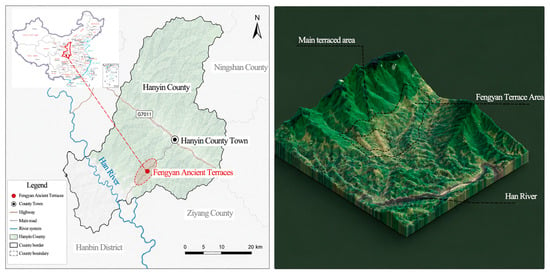
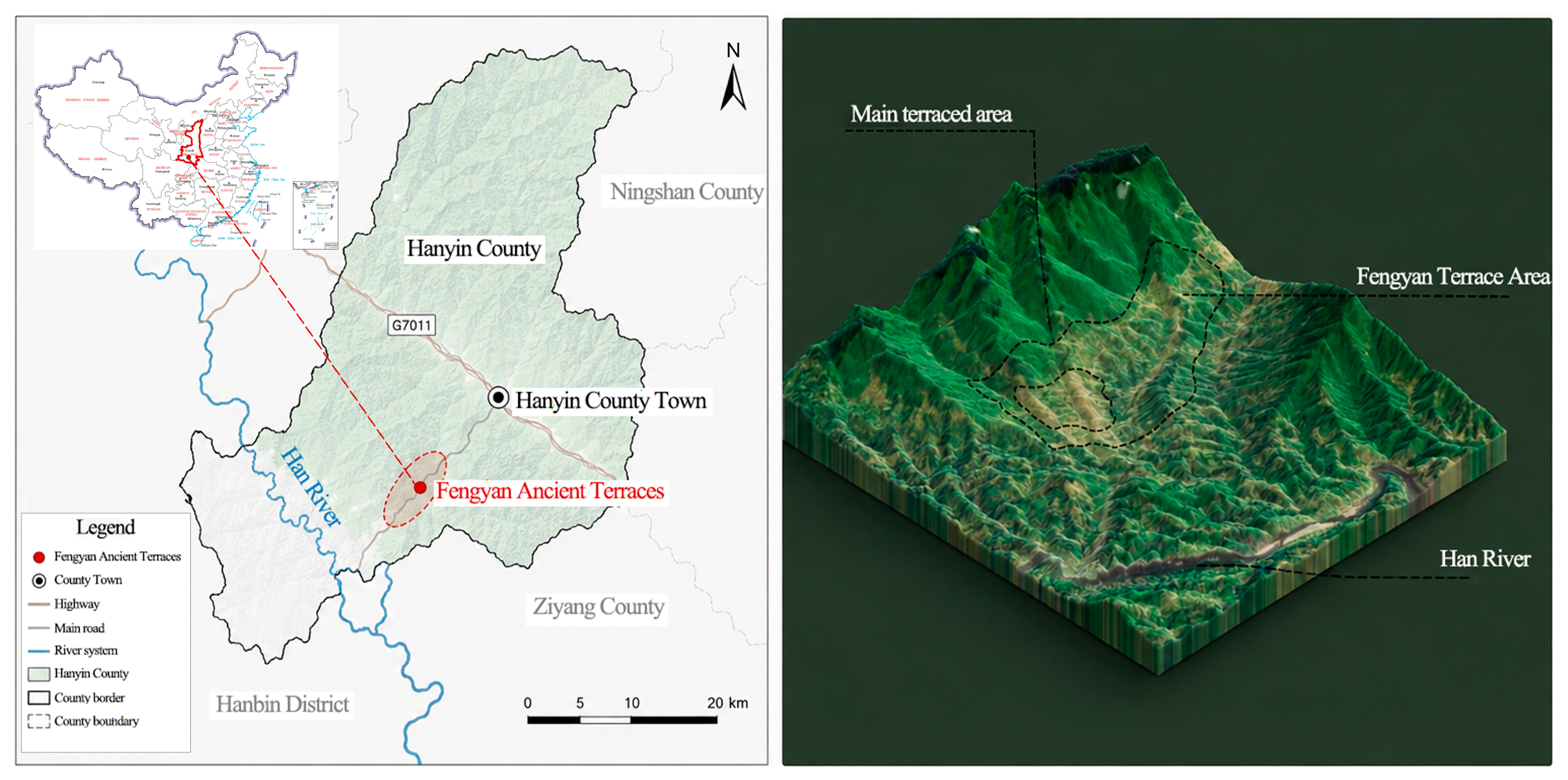
The Fengyan Terraced Fields are located in Hanyin County, in the south of Shaanxi Province (Figure 1), in the gentle-slope valley area of the Qinba Mountains, with an elevation ranging from 304 m to 893 m and slopes varying between 0° and 45° [25]. The terraces are irrigated by gravity-fed stream water from four gullies, namely Huanglong, Cigou, Lengshui, and Longwang, with an irrigated area of approximately 3467 hm2. During the Qianlong period of the Qing Dynasty (1763), immigrants of the Wu clan from Hunan Province settled here and introduced the southern “drainage and storage” water-conservancy techniques into the Qinba Mountains. During this period, trade in mountain products gradually developed through the Han River water transport and the ancient Chang’an commercial road, forming a trade network connecting southward to Hanzhong and Wuhan and northward to Chang’an [25]. Settlements gradually expanded from Yanping Village to Donghe, Fengjiang, Huanglong, and other villages; defensive dwellings, fortresses, temples, ancestral halls, and other vernacular buildings were constructed on a large scale, and agricultural production, clan society, and trade circulation jointly shaped the regional cultural landscape. After more than two hundred years of evolution, the area preserves material elements such as the mountainous terrace system, traditional settlements, ancient water-conservancy remains, and commercial-road relics, while also retaining intangible culture derived from migration, including folk customs, folk opera, and clan beliefs, making it a typical mountainous rural cultural landscape that integrates a distinctive farming system, settlement form, and social-commercial network [26].
Figure 1.
Geographic location and 3-D terrain view of the Fengyan Ancient Terraces. The left panel presents the administrative location of the study site within Hanyin County, Shaanxi Province, with an inset map showing its position in China. The right panel shows the three-dimensional terrain rendering of the Fengyan terrace area, marking the main terraced zone and the Han River. Source: Authors’ elaboration based on the standard map of the Ministry of Natural Resources (Map Approval No. GS (2019) 1652), and DEM data obtained from the Geospatial Data Cloud.
The Fengyan Terraced Fields have both national and international heritage status. It is designated as a Major Historical and Cultural Site Protected at the National Level, China Nationally Important Agricultural Heritage System, National Water Conservancy Scenic Area and National 4A-level Tourist Attraction. Moreover, in 2024 the site was recognized by the International Commission on Irrigation and Drainage (ICID) as a World Heritage Irrigation Structure. Local authorities have delineated protection zones and construction control zones, enacted special local regulations, restored ancient terraces and irrigation canals, provided agricultural subsidies, constructed an immigration eco-museum, and implemented living heritage conservation to balance heritage preservation and regional development [27].
The cultural data in this study were obtained from the research team’s field investigations and literature review, combined with field visits, landscape element surveys, and the collation of historical materials, and supplemented by reference to the Hanyin County local gazetteer, local archives, and the heritage registration materials of the Fengyan Terraced Fields, so as to identify material and intangible cultural landscape remains closely related to immigrant reclamation, agricultural production, and trade circulation. The production and ecological data sources are as follows (Table 1):
Table 1.
Production and ecological data sources.
3. Materials and Methods
3.1. Multi-Dimensional Coupling Mechanism of Biocultural Diversity in Rural Cultural Landscapes
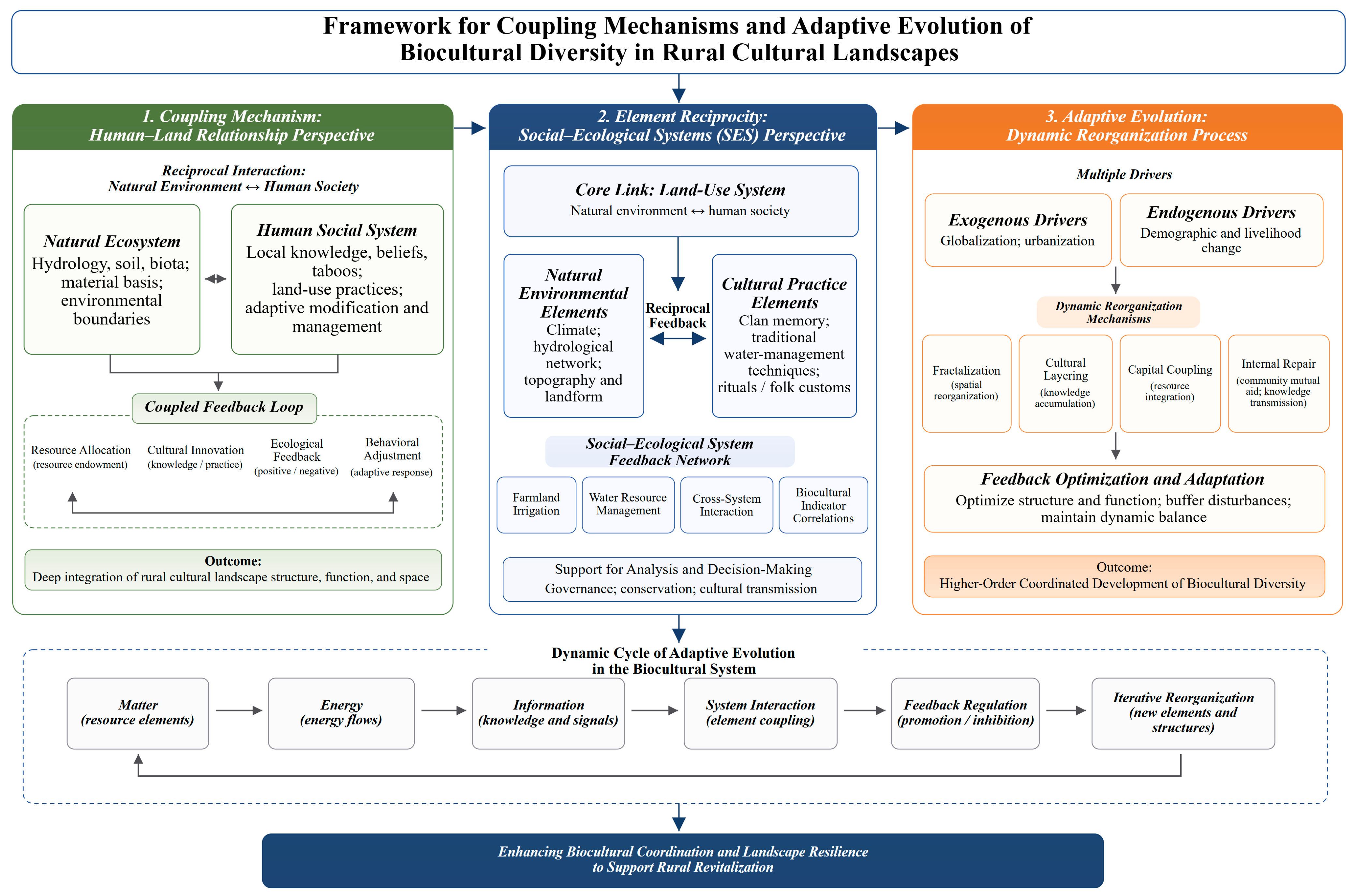
Rural cultural landscapes are the product of humans adapting to the natural geographical environment and of long-term human–land interactions [9,28], and their evolutionary mechanisms can be comprehensively explained through human–land relationship theory, SES theory, and the logic of adaptive system evolution. From the perspective of human–land coupling, rural ecosystems provide the material basis and environmental boundary for human survival, and humans transform and manage nature through local knowledge, folk taboos, and distinctive land-use practices [29,30], forming a closed-loop evolutionary process of “resource allocation-cultural innovation-ecological feedback” and achieving the deep integration of rural landscape structure, function, and space [30,31].
Based on SES theory, land use is the core link connecting the natural system and human society [32,33]. Natural conditions such as climate, topography, and hydrology constrain land development and use, while human practices such as clan memory, traditional water-conservancy techniques, and folk activities regulate land-use and management patterns, forming a bidirectional feedback relationship with land as the carrier [21]. Through vernacular techniques such as terrace construction and water-diversion irrigation, humans transform the microenvironment and shape distinctive agricultural landscapes; the resulting landscape achievements further settle into collective memory, strengthen regional identity, and enhance the locality and livelihood resilience of rural areas [34,35].
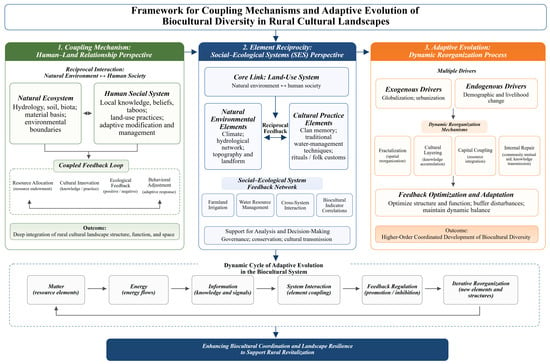
From the perspective of system evolution, the rural biocultural system takes matter, energy, and information as its core elements, activates its evolutionary dynamics through human–land coupling, adapts to external disturbances through internal element interactions, and achieves structural renewal and functional upgrading through fractalization, layering, and coupling [23,24], while continuously optimizing its adaptive capacity through sustained feedback [36,37]. External disturbances such as globalization and urbanization and endogenous changes such as population and livelihood transformation jointly break the steady state of the system and drive the reorganization and reconstruction of rural landscape structure and function [38,39]; internal repair mechanisms such as community mutual assistance and the transmission of traditional knowledge can buffer external disturbances and promote the higher-order coordinated development of biocultural diversity [39,40]. The rural biocultural system has the characteristics of dynamic iteration and self-reconstruction; it can optimize the system and maintain landscape resilience through continuous interactive repair. Clarifying the laws of its circular feedback evolution is key to analyzing the evolutionary mechanisms of rural landscapes and interpreting their development trends (Figure 2).
Figure 2.
Multi-dimensional coupling mechanism of biocultural diversity in rural cultural landscapes. The analytical framework consists of three interlinked modules: the human–land coupling mechanism from the human–land relationship perspective, element reciprocity based on the social–ecological system (SES) perspective, and adaptive evolution representing the dynamic reorganization process. It further illustrates the cyclic adaptive evolution of the biocultural system and the ultimate goal of enhancing biocultural coordination and landscape resilience to support rural revitalization. Source: Authors’ elaboration.
These perspectives are linked to the analytical design in a stepwise manner (Figure 2). The human–land perspective specifies the coupled system and the ecological constraints and human transformations to be observed. The SES perspective organizes those observations into ecological, production, and cultural dimensions. Landscape character zoning compares their spatial context, stage reconstruction describes selected indicators over time, and the semi-quantitative assessment and GeoDetector analysis explore cross-dimensional differences and interaction patterns. Adaptive-cycle thinking guides the interpretation of the three temporal stages, without treating those stages as a causal test or as the source of every indicator.
3.2. Assessment of Spatial Coupling Relationships
3.2.1. Spatial Feature Identification and Zoning
This study combines locational conditions with land-cover heterogeneity to conduct spatial feature identification and element analysis in typical sample areas (the sample-area size is determined according to the scale of the study area, such as 3000 m × 3000 m and 500 m × 500 m). In this study, the first analytical scale was selected as 3000 m × 3000 m to ensure that the main topographic gradients, settlement distribution, terrace pattern, hydrological structure, and heritage remain were all represented within a unified analytical frame.
The landscape character zoning procedure was standardized into three sequential, explicit steps to ensure rigorous and credible delineation of spatial units:
(1) Data preprocessing and core element screening. Six core elements, including elevation, slope, hydrology, land use, settlement distribution, and heritage sites, were selected to support comprehensive landscape zoning. Topographic variables were derived from a Digital Elevation Model (DEM). All multi-source spatial datasets were uniformly projected to a consistent coordinate system (e.g., WGS-1984), standardized into unified raster or vector formats, and spatially raster-matched to guarantee cross-data comparability. This preprocessing workflow achieved unified spatial registration and enabled effective overlay analysis of multi-dimensional topographic, hydrological, land-use, and heritage spatial information.
(2) GIS overlay and interpretive clustering for preliminary zoning. The six preprocessed core elements were integrated and overlaid in a GIS environment to generate preliminary zoning candidates. This step identified spatial units with homogeneous combinations of topographic conditions, hydrological services, land-use structures, settlement patterns, and heritage aggregation levels. Rather than adopting a purely automatic algorithm-based classification, this study applied a comparative and interpretive clustering strategy. Specifically, study areas were first grouped according to topographic gradients and hydrological configurations, and further subdivided based on land-use compositions, settlement agglomeration degrees, terrace reclamation sequences, and heritage site densities. On this basis, the terraced core area was preliminarily divided into distinct landscape spatial units.
(3) Boundary verification and revision for final zoning. The preliminary zoning boundaries were systematically examined and adaptively revised by integrating historical terrace reclamation records, remote sensing interpretations, and field survey observations, ultimately yielding five refined landscape-character zones. This manual calibration process ensured that each delineated zone constituted an ecologically, productively, and culturally coherent spatial unit. The finalized zoning scheme provided a reliable foundation for subsequent evolutionary stage reconstruction, expert quantitative scoring, and multi-element coupling analysis in this study.
3.2.2. Temporal Analysis of Spatial Features
Four indicators-settlement agglomeration degree, heritage-site density, land-use complexity, and terrace continuity-were selected to quantitatively measure the different evolutionary stages of the Fengyan Terraced Fields. This indicator set aims to comprehensively reflect the spatial organization characteristics and evolutionary trajectory of the terraced landscape from four dimensions: settlement organization, cultural accumulation, land allocation, and landscape morphology.
Based on historical documents, current spatial identification, remote-sensing interpretation, and field-survey data, the landscape evolution of the Fengyan Terraced Fields was divided into three stages: the traditional reclamation and pattern-founding period, the agricultural expansion and system-stabilization period, and the tourism-driven transformation and reorganization period (Table 2). The four core indicators of each stage were scored using explicit rules, and a 1–5-point grading method was used for comparative analysis (Table 3). A higher score indicates stronger spatial organization, greater cultural accumulation, or greater landscape continuity represented by the indicator. Finally, a comprehensive evolution index was obtained as the mean of the four indicators. A total of five professionals were invited for the evaluation process (Supplementary Section S1). The tie-corrected Kendall’s coefficient of concordance (Kendall’s W) was used to test expert-scoring consistency.
Table 2.
Historical evolution stages of the Fengyan Terraced Fields.
Table 3.
Indicator grading criteria.
3.3. Assessment of Element Coupling Relationships
3.3.1. Evaluation Indicator System
The SES perspective is the main organizing logic for the E, P, and C criterion layers; human–land relationships inform the selection of observable features, with spatial analysis, historical materials, field observations, and case-specific data availability determining the final indicators, whereas adaptive-cycle thinking informs only the temporal interpretation. According to the analytical framework proposed in Section 3.1, the core components of the terraced cultural landscape were classified into three dimensions (ecological basis, production organization, and cultural inheritance), and 12 corresponding indicators were formulated (Table 4). Ecological indicators reflected topographic–hydrological constraints and supports for settlement and cultivation; production indicators described the integrity, accessibility and organizational maturity of farming systems; cultural indicators characterized the diversity, traceability and morphological integrity of heritage landscape characters. To remedy the weaknesses of conventional qualitative interpretation in detecting element feedback intensity and coupling relationships, this study built the indicator system based on spatial identification, historical textual verification and field investigation. All indicators adopted a standardized five-level assignment scheme (1–5 points), whereby only integer and half-integer values were permitted, and higher scores denoted greater suitability, structural integrity, or coupling level of landscape elements. This rule-based quantification transformed multi-source geographic information into comparable numerical data and enhanced discrimination of spatial heterogeneity across landscape zones.
Table 4.
Evaluation indicator system for element feedback and coupling relationships in the Fengyan Terraced Fields.
The 1–5 scoring rules were applied according to the following principles.
- (1)
- Connectivity/accessibility indicators (e.g., water-system connectivity, farming accessibility) were scored from low to high according to proximity, continuity, and ease of connection among key spatial elements.
- (2)
- Suitability indicators (e.g., slope suitability, elevation suitability) were scored according to the relative appropriateness of terrain conditions for terrace cultivation and habitation.
- (3)
- Complexity/continuity indicators (e.g., topographic complexity, terrace continuity, land-use complexity) were scored according to the degree of structural richness, compositional balance, and spatial integrity.
- (4)
- Cultural accumulation indicators (e.g., heritage-site density, heritage-type diversity, historical duration, landscape authenticity) were scored according to density, richness of categories, traceable historical depth, and completeness of preserved traditional patterns.
Because some cultural indicators are derived from field observation and historical-material interpretation, the scoring system should be understood as a rule-based semi-quantitative assessment rather than a purely objective measurement procedure. A total of five professionals were invited for the evaluation process. The tie-corrected Kendall’s coefficient of concordance (Kendall’s W) was used to test expert-scoring consistency (Supplementary Section S2). The final score of each indicator was obtained by multiplying the average expert-scored value by its corresponding weight, with weights determined jointly by relevant professionals (Supplementary Section S2, Section S2.1).
where Xij is the weighted score of indicator j in zone i, is the average expert score of the i zone for the j indicator, wj is the corresponding indicator weight.
3.3.2. Element Coordination and Feedback
The criterion-layer indices were denoted as E, P, and C, respectively, and the comprehensive score was calculated using the weighted average method. To reflect the coordination and feedback relationships among the three types of elements, two auxiliary indicators—the comprehensive feedback index (FFI) and coupling-coordination degree (D) [42] were constructed:
where Ei, Pi, and Ci denote the scores of each criterion-layer for the i-th region. FFIi represents the regional comprehensive mutual-feedback index.
where U denotes the standardized score of the subsystem, C indicates the coupling closeness among the three types of elements, T stands for the comprehensive development index, and D refers to the coupling-coordination degree. D ∈ [0, 1]; the larger the value of D, the higher the level of coupling-coordination. The numerical results adopted in this paper come from quantitative auxiliary measurements based on existing materials, which are used to enhance the visualization and explanatory power of comparative analysis rather than to replace field-monitoring data.
FFIi = (Ei + Pi + Ci)/3
Example: Zone 1
UE = 4.20/5 = 0.84;UP = 4.50/5 = 0.90;UC = 3.625/5 = 0.725
T = (0.84 + 0.90 + 0.725)/3 = 0.8217
3.3.3. Element Synergy and Trade-Off
This study employed the GeoDetector model to conduct factor detection and interaction detection [43,44]. The dependent variable was the sub-unit-scale FFIsub comprehensive feedback index, denoted as Y, while the independent variables consisted of 12 indicator factors, denoted as X1–X12. This study adopted the “sub-unit calibration and assignment under the constraint of first-level unit” method to reconstruct discrete datasets of independent and dependent variables at the defined sub-unit scale (the sub-unit in this study is 500 m × 500 m), to obtain the sample size and discrete spatial data required for the GeoDetector analysis. This subdivision yielded a total of 168 sub-units (N = 168) for the GeoDetector analysis. The q statistic is used to quantify the independent explanatory power of each indicator factor as well as the interactive effects between pairwise factors, where q ranges from 0 to 1 and a larger value indicates stronger explanatory power. The exact discretization and stratification rules for all GeoDetector variables are provided in Supplementary Section S3.
Factor detection is used to calculate the explanatory power of a single factor on the spatial differentiation of the system. The q statistic is calculated as follows:
where h is the stratification category of the factor; L is the total number of strata; Nh and σh2 are the sample size and variance of stratum h, respectively; N and σ2 are the total sample size and the global variance, respectively. The closer q is to 1, the stronger the explanatory power of the factor on the spatial differentiation of the dependent variable.
q = 1 − [Σh=1L Nhσh2]/(Nσ2)
Interaction detection compares the q value of a single factor with the interaction q value of two superimposed factors to determine the type of factor interaction. The criteria are listed in Table 5. In particular, bi-factor enhancement refers to cases where the interaction q value is greater than the explanatory power of either single factor but still smaller than their sum, whereas nonlinear enhancement refers to cases where the interaction q value exceeds the sum of the two individual q values.
Table 5.
Criteria for factor-interaction detection based on GeoDetector.
To further examine whether the three subsystem dimensions tend toward coordination or opposition, Pearson correlation coefficients were calculated among E, P, and C across the landscape character zones. Considering the limited number of spatial units in this study, these correlation results are reported as exploratory evidence only.
where r is the Pearson correlation coefficient, xi and yi denote the i-th observed sample value of the two subsystems; and are the sample means; and n is the total number of samples. When r > 0, the subsystems are in a synergy relationship; when r < 0, they are in a trade-off relationship; and a larger |r| indicates a stronger correlation; and r = 0 indicates no linear association. Considering the small number of spatial units, these correlation results are interpreted only as exploratory evidence of synergy or trade-off tendencies rather than as definitive system relationships.
4. Results
4.1. Spatial Coupling Relationships of Biocultural Diversity in the Terraced Fields
4.1.1. Results of Landscape Character Zoning
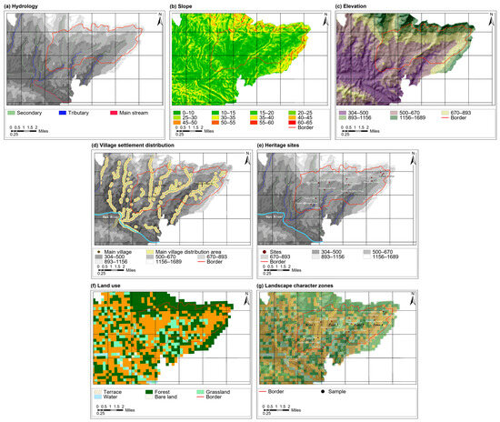
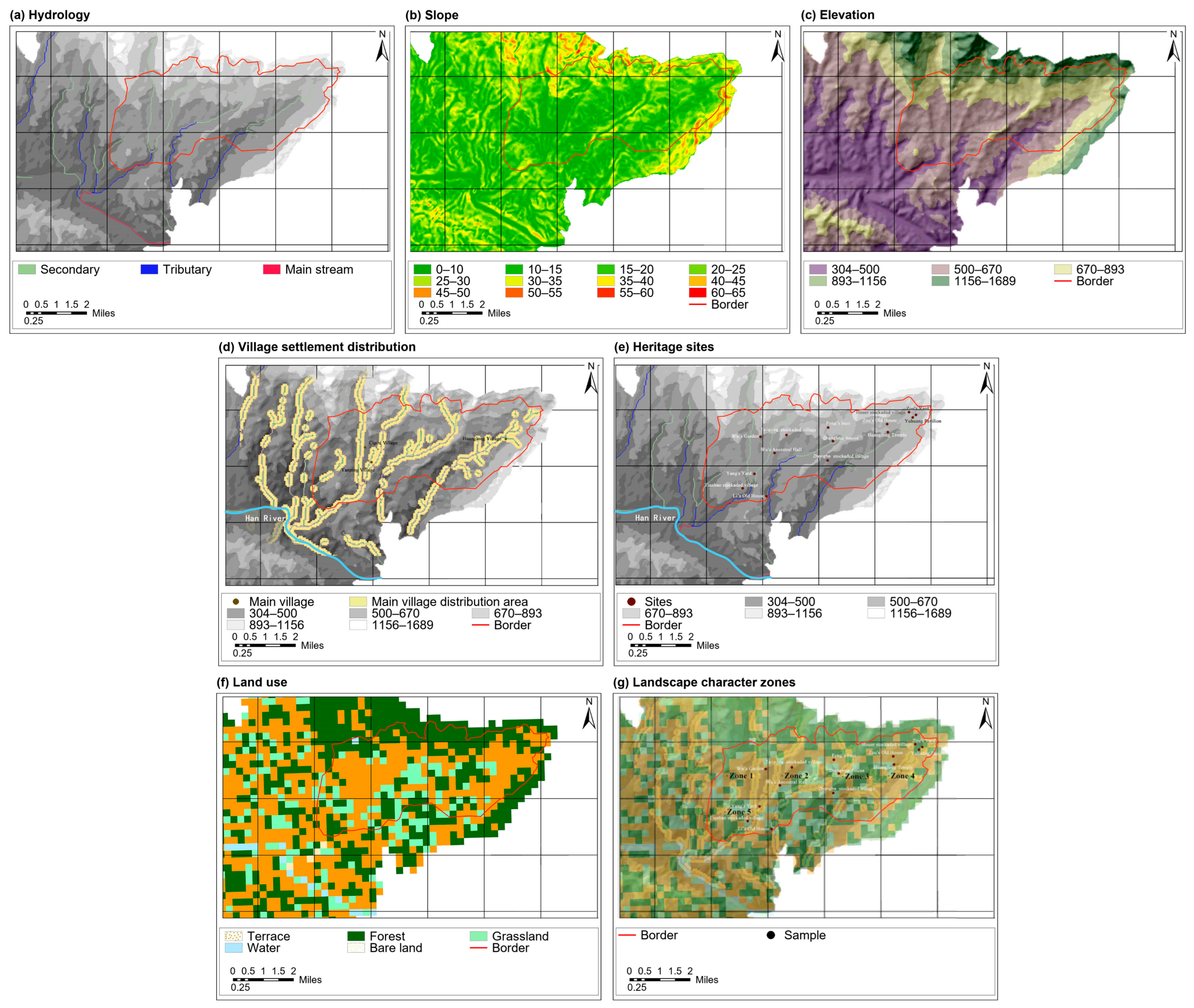
Following the spatial identification procedure in Section 3.2.1, a 3000 m × 3000 m sample area was selected for feature and element analysis. The core elements include elevation, slope, hydrology, land use, settlement, and heritage sites. By combining the historical reclamation sequence with the spatial differentiation of landscape elements, the terraced core area was divided into five types of landscape character zones (Figure 3, Table 6). The zones show pronounced gradient differences in natural base conditions, agricultural production patterns, and cultural heritage configuration, presenting a spatial pattern of coordinated differentiation among topographic constraints, artificial modification, and cultural construction, and constituting a differentiated foundation for ecological-production-cultural coupling.
Figure 3.
Multi-element spatial characteristics and landscape character zones: (a) hydrology (river-network flow); (b) slope gradient; (c) elevation; (d) village settlement distribution; (e) heritage sites; (f) land-use conditions; (g) landscape character zones. Spatial analysis and data processing were performed using ArcGIS 10.8. Source: Authors’ elaboration.
Table 6.
Core characteristics of the five landscape character zones.
The results show that the five landscape zones exhibit a pronounced gradient differentiation pattern (Figure 3, Table 6). Zone 5 at low elevation has the optimal matching of water and soil resources, a highly coupled “production-living-ecological” space, and favorable low-elevation water–soil and spatial conditions. Zones 1 and 2 at middle–low elevations have a long development history and a mature agricultural base; among them, Zone 2 achieves a balanced adaptation of ecological, production, and cultural elements and is a typical stable landscape unit. Zone 3 at middle–high elevation has a superior ecological base, but its terrace production pattern is fragmented and its cultural landscape development is moderate. Zone 4 at high elevation relies on excellent ecological and production conditions to form the richest cultural heritage system in the entire area, achieving high-quality coupled development of the mountainous landscape.
The spatial characteristics of the Fengyan Terraced Fields result from the joint action of natural topographic and hydrological constraints, staged artificial reclamation, and immigrant cultural construction, forming a nested mountainous agricultural landscape structure characterized by “intensive adaptation at low elevations, balanced development at middle elevations, ecological conservation at high elevations, and clustered cultural features along elevational gradients.” This lays the spatial foundation for the subsequent multi-element coupling evaluation and evolutionary mechanism analysis.
4.1.2. Temporal Evolution of Spatial Features
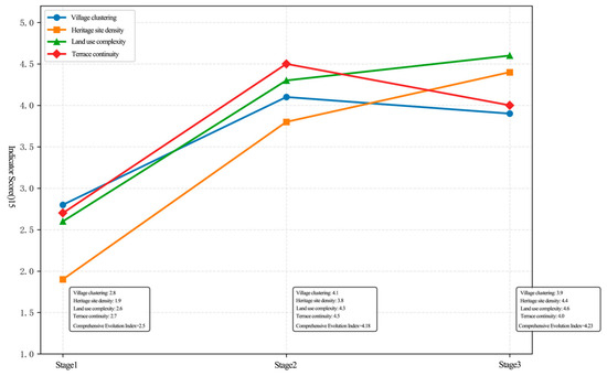
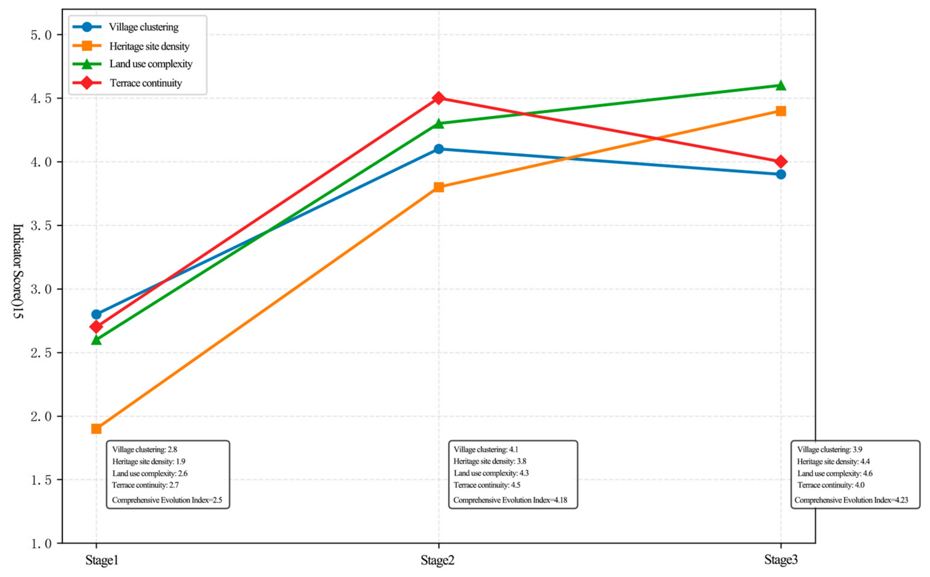
Using the stage definitions and scoring criteria in Table 2 and Table 3 (Section 3.2.2), the reconstructed landscape evolution of the Fengyan Terraced Fields exhibits distinct stage characteristics, undergoing a dynamic process from “initial construction” to “stable expansion” and then to “transformation and reorganization” (Table 7, Figure 4).
Table 7.
Core indicator measures across the different evolution stages.
Figure 4.
Evolution paths of indicators across the temporal stages. The temporal scoring is a semi-quantitative reconstruction based on historical documents, current spatial identification, and field evidence, and should be understood as a comparative representation of stage characteristics rather than an exact historical measurement. Source: Authors’ elaboration.
In the traditional reclamation and pattern-founding period, the four indicators were generally at low levels. The settlement agglomeration degree, heritage-site density, and land-use complexity showed no stable high values, indicating that the settlement space had not yet been finalized and that the human–land coupling relationships among terraces, water systems, and villages remained rudimentary; the relatively weak terrace continuity directly reflected the limited reclamation scale and the absence of a core spatial structure for the terraced landscape. This stage centered on reclamation trials, settlement siting, and the initial establishment of the farming system, representing the initial generation stage of the terraced landscape system.
Entering the agricultural expansion and system-stabilization period, the four indicators all increased to varying degrees, with terrace continuity and land-use complexity showing the most prominent growth, marking the formation of a complete spatial structure and a mature production-function system for the terraced landscape. The rise in settlement agglomeration indicates that the settlement layout tended to stabilize and formed a close spatial association with mountains, water, and cultivated land; the increase in heritage-site density reflects the continuous accumulation and consolidation of cultural elements such as clan, governance, and defense. This stage is the mature period of the traditional farming system and also the most stable stage of the landscape’s ecological–production–cultural coupling.
In the tourism-driven transformation and reorganization period, heritage-site density and land-use complexity continued to rise, consistent with heritage conservation and revitalization, and traditional cultural elements were reactivated in a modern context. The settlement agglomeration degree remained at a high level with slight fluctuations, reflecting the transformation of villages from a single production-living space into a composite space integrating residence, service, and display. The slight decline in terrace continuity does not indicate damage to landscape integrity but rather reflects the conversion of some purely agricultural spaces into landscape-experience spaces under tourism development, optimizing and adjusting the proportion of contiguous productive terraces and achieving functional reorganization of the system. This stage completed the adaptive transformation from a traditional farming system to a composite heritage tourism-ecological agriculture system.
The four reconstructed indicator trends (Table 7; Figure 4) suggest that the landscape evolution of the Fengyan Terraced Fields was not a linear increase but a dynamic path of “formation–stabilization–reorganization” in historical development. The second stage corresponds to the maturation and consolidation of the traditional farming system, while the third stage reflects the adaptive-cycle interpretation, in which the system sustains itself through functional reorganization under the impact of modernization. This result indicates that the core value of the Fengyan Terraced Fields lies not only in the preservation of the physical landscape itself but also in the long-maintained human–land coupling relationships and the system’s self-adjustment capacity under external disturbances.
4.2. Element Coupling Relationships of Biocultural Diversity in the Terraced Fields
4.2.1. Synergy and Feedback Relationships Among Biocultural Elements
The results show that the characteristic zones exhibit high consistency across the ecological-production-cultural dimensions, but clear differences remain among the zones, reflecting the detailed regulatory role of local knowledge on the landscape pattern (Table 8).
Table 8.
Element synergy and feedback measures for the five landscape character zones.
The Fengyan Terraced Fields showed consistently high coupling among the ecological, production, and cultural subsystems, with coupling degree values close to 1.00 in all five zones, indicating a high degree of coupling as defined by the index. However, the T and D displayed clear spatial variation. This pattern indicates that although the three subsystems were closely linked in all zones, differences in coordination level were mainly associated with variation in overall developmental strength rather than with the coupling term itself.
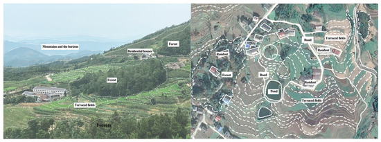
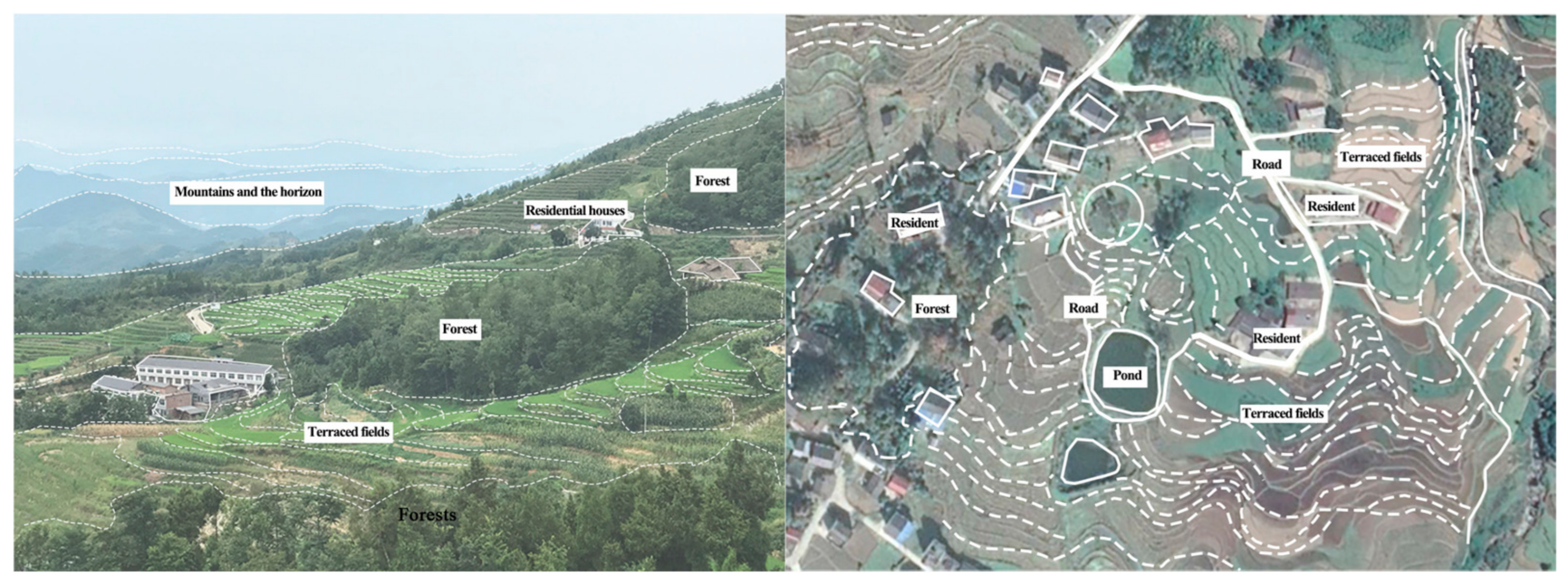
Ecologically, zones with stronger water-system connectivity generally exhibited higher ecological index values, consistent with the hydrological network serving as a foundation for the formation and maintenance of the terraced landscape. In the high-elevation areas (670–893 m), primary forest provides stable water conservation functions, while tributaries, ponds, and terrace canal systems together form a hierarchical micro-water-circulation network that regulates and redistributes surface runoff. This not only enhances water-use efficiency but also contributes to slope stability and ecological resilience (Figure 5).
Figure 5.
Spatial elements and structure. The left aerial photograph presents the real landscape with interlaced forest, residential buildings and terraced farmland, while the right diagram interprets the composite spatial pattern of settlement-pond-road-terrace. Source: Field photographs taken by the authors.
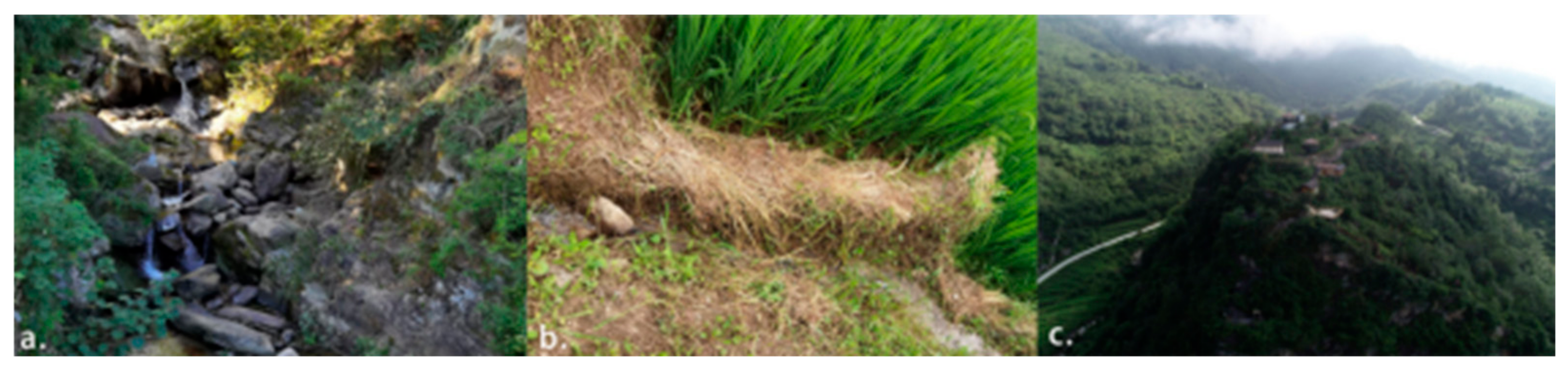
Culturally, zones with higher heritage-site density and richer heritage diversity also tended to show higher cultural indices and stronger feedback intensity, suggesting that cultural elements are integral to landscape continuity rather than secondary attachments. Traditional farming techniques, settlement organization, and the spatial distribution of temples and ancestral halls together reflect the embedded role of local knowledge and spiritual beliefs in regulating land use and resource management (Figure 6).
Figure 6.
Traditional irrigation facilities and heritage sites: (a) stone water-diversion structure following the terrain; (b) traditional earth field ridges and branch channels; (c) hilltop temple. Source: Field photographs taken by the authors.
The spatial coupling relationships of the Fengyan Terraced Fields show a pronounced “ecological–cultural embeddedness” characteristic: the natural landform provides constraints, local knowledge completes the technical translation, and spiritual beliefs strengthen institutional constraints, jointly solidifying biocultural diversity into the spatial structure. Therefore, the terraced landscape should be understood as a coupled human–environment system in which ecological processes, agricultural production, and cultural heritage jointly sustain landscape stability and regional differentiation.
4.2.2. Synergy and Trade-Off Relationships Among Biocultural Elements
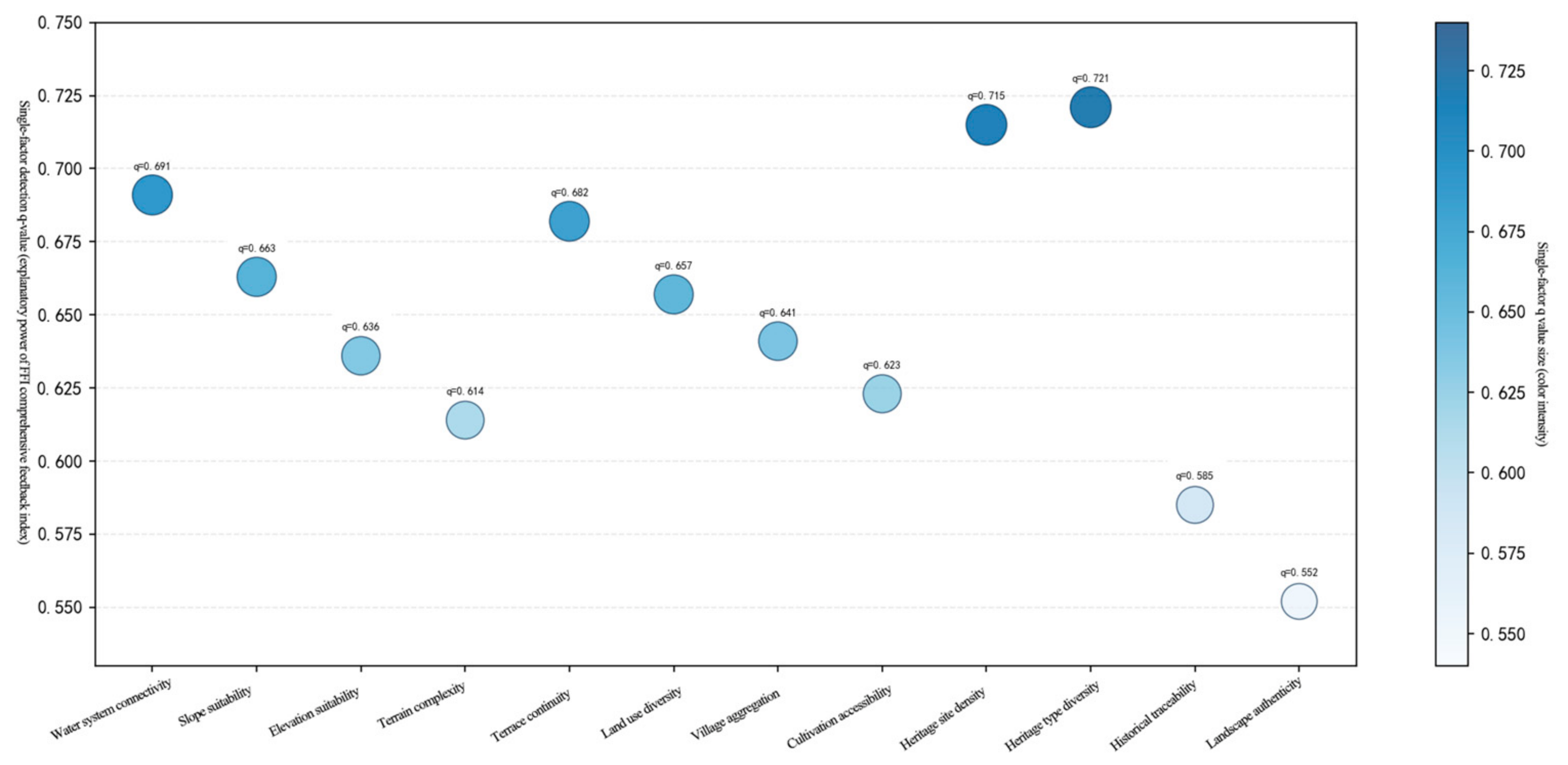
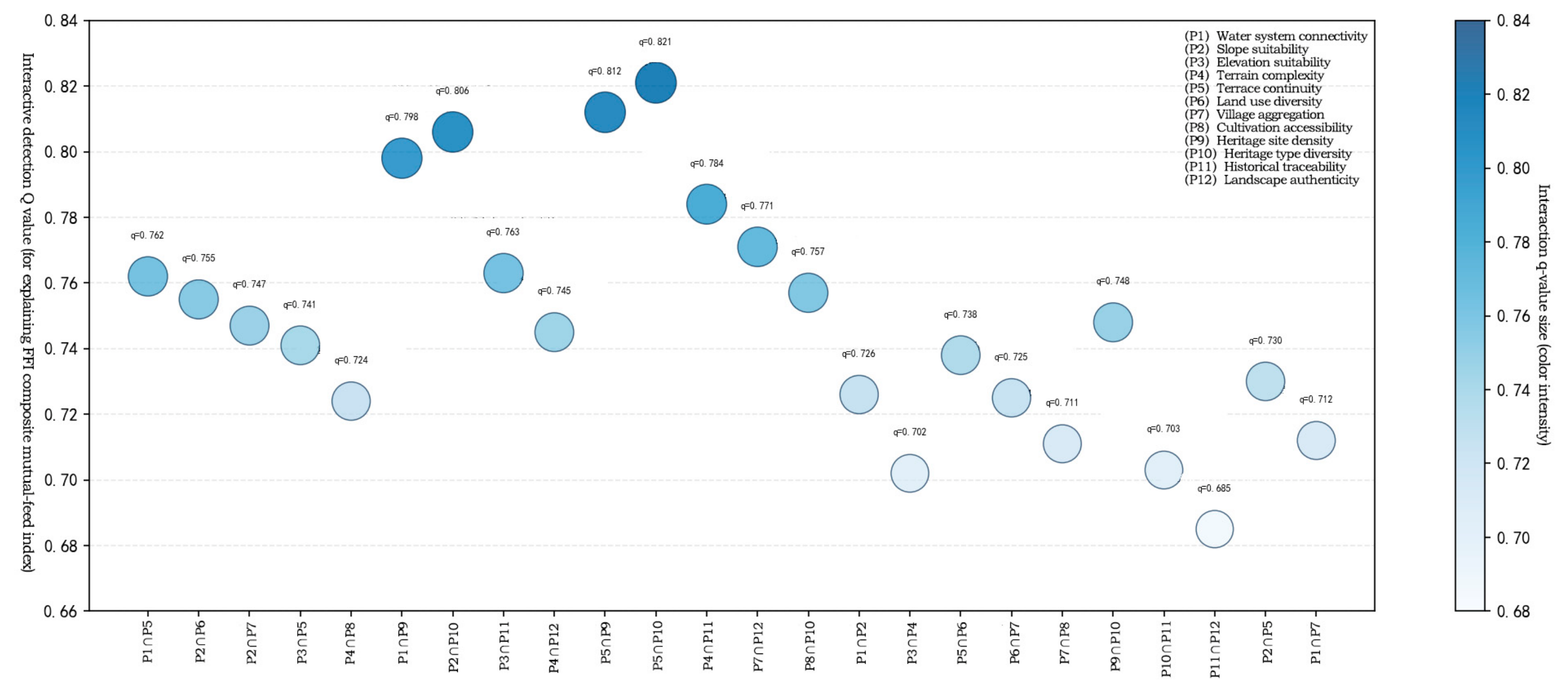
Following the sub-unit procedure in Section 3.3.3, the landscape character zones were subdivided into 500 m × 500 m sub-units. There were a total of 168 sub-units, which provided sufficient samples for GeoDetector analysis (Supplementary Section S3). At the scale of the characteristic zones, the GeoDetector model was introduced to conduct sub-factor exploratory analyses. The focus was on identifying the explanatory power of the different dimensions for feedback intensity (FFIsub) and their interactive enhancement characteristics, with FFIsub as the dependent variable Y, and with the reclassified 12 factors as independent variables X (Figure 7 and Figure 8). Since only five zones were delineated in this study, the sample size was too small for regression-based VIF multicollinearity diagnostics. Meanwhile, GeoDetector does not impose strict restrictions on multicollinearity among independent variables. All twelve indicators were imported for factor-detection analysis, and the interpretation of outputs for highly correlated indicators was treated cautiously in subsequent discussion.
Figure 7.
Single-factor detection of the 12 factors. The bubble chart visualizes the q-statistic values reflecting explanatory power for each individual indicator factor, and bubble color denotes the magnitude of q-values. Source: Authors’ elaboration.
Figure 8.
Interaction detection of the 12 factors. All 12 factors passed the significance test at p < 0.05, indicating that the detected q-statistic results of explanatory power were reliable at the 95% confidence level. Source: Authors’ elaboration.
(1) Correlation characteristics of trade-off and synergy (Table 9):
Table 9.
Pearson correlations among ecological, production, and cultural indices across the five landscape character zones.
Pearson correlation analysis was performed for the five landscape character zones to examine trade-off and synergy relationships among E, P, and C subsystems. Owing to the small number of spatial samples, these results should be regarded as exploratory rather than conclusive.
E-P exhibited a relatively strong positive association (r = 0.915, p = 0.029), indicating that zones with favorable ecological conditions tend to have greater terrace continuity, land-use complexity and settlement agglomeration, consistent with ecological conditions supporting the spatial organization of terraced farming. Similarly, P-C showed a clear positive association (r = 0.894, p = 0.041): zones characterized by well-developed production organization contain denser, more diverse heritage sites, reflecting substantial spatial embeddedness between traditional farming systems and local cultural inheritance.
E-C had a moderate positive association (r = 0.769, p = 0.129). This suggests that the spatial pattern of cultural elements is not directly determined by ecological settings; instead, cultural attributes are indirectly mediated by settlement layout, farming activities and indigenous belief systems, forming an indirect linkage between ecology and culture.
The three functional dimensions show predominantly positive spatial associations without marked mutually constraining trade-offs. Nonetheless, the comparatively weaker E-C linkage points toward a latent possibility of internal functional differentiation. Local zones subject to stringent ecological constraints and weak village-level organization may exhibit asynchronous development across the three subsystems, which may be associated with functional divergence and lagged evolutionary transitions of the terrace heritage system.
(2) Factor detection results (Figure 7): E and P have strong and similar explanatory power, with the q values of the E-dimension sub-factors ranging from 0.614 to 0.691 and those of the P-dimension sub-factors ranging from 0.623 to 0.682, indicating that in the Fengyan Terraced Fields, ecological base conditions and production organization are the important structural correlates of differences in system feedback intensity. The explanatory power of the internal factors of C is clearly differentiated: heritage-type diversity (q = 0.721) and heritage-site density (q = 0.715) have relatively high single-factor explanatory power, while the single-factor explanatory power of historical verifiability and landscape authenticity is relatively limited; the overall average explanatory power of the cultural dimension is lower than that of the ecological and production dimensions. This pattern is compatible with a “stabilizing additive” role for cultural inheritance in the FFI-based assessment in the context of small spatial heterogeneity and a high overall degree of heritage preservation.
(3) Interaction detection results (Figure 8): all factor combinations show bi-factor enhancement effects under the criteria in Table 5, with no nonlinear attenuation or independent effects.
The results indicate that the FFI-based mutual feedback pattern of the Fengyan terrace system is associated with the combined effects of multiple factors. Clear differences occur in the interaction effects across different dimensions. The cross-dimensional interaction between production and culture yields the highest explanatory performance. The interactions between terrace continuity and heritage-type diversity (q = 0.821), as well as between terrace continuity and heritage-site density (q = 0.812), are particularly prominent. This reflects a favourable spatial matching between the spatial pattern of terrace farming and the distribution of cultural heritage; the coupling and linkage of these two sets of factors can effectively improve the explanatory capacity for the spatial differentiation of systematic mutual feedback. The interaction between ecology and culture ranks second. Topographic, river-network and other underlying ecological conditions can form adaptive coupling with cultural heritage elements, which is consistent with a structural role for the persistence and spatial differentiation of cultural landscapes.
In comparison, the interaction gain within the ecological–production dimension is relatively limited, with a small increment in explanatory power. This may reflect the relatively high spatial consistency between the ecological background and farming-production pattern in the study area, whereby the superposition of factors scarcely generates remarkable incremental explanatory effects. The internal factor interactions within each dimension are generally weaker than cross-dimensional combinations. The coupling of internal ecological and production factors only produces slight enhancement, while the internal interaction of cultural-dimension factors shows the lowest magnitude. These patterns suggest that the explanatory contribution of combined individual cultural factors is comparatively restricted, and cultural indicators show stronger interaction enhancement when combined with ecological and production indicators. This is consistent with the finding from the single-factor detection that the cultural dimension has lower average single-factor explanatory power and stronger cross-dimensional interaction enhancement.
5. Discussion
5.1. Core Research Findings
This paper suggests that the biocultural diversity of the Fengyan Terraced Fields is the result of the long-term co-evolution of ecological processes, production practices, and cultural institutions. This finding indicates that agricultural heritage research should not remain at the level of landscape-pattern identification or heritage-value description but should further attend to the potential roles of local knowledge, social organization, and cultural norms in landscape formation and system continuity. In particular, although the cultural dimension did not show the highest average single-factor explanatory power, it showed pronounced interaction enhancement in the exploratory analysis, suggesting that culture is not merely an additional landscape attribute but an embedded component associated with the continuity of mountainous agricultural heritage.
The Fengyan Terraced Fields show predominantly positive associations among ecological, production, and cultural dimensions. Tourism and changing livelihoods may alter the relation between productive terraces, heritage display, and local practice, making continued observation of these links important for interpreting the landscape’s adaptive reorganization.
5.2. Methodological Contributions
The methodological contribution of this study lies in integrating analytical tasks that are often treated separately. Heritage-value identification can locate important remains, while landscape-pattern mapping and single-time assessment can describe their physical setting; neither approach alone readily links spatial differentiation, staged historical transformation, and interactions among ecological, production, and cultural attributes. This study first delineates landscape character zones from terrain, hydrology, land use, settlement, and heritage evidence; then reconstructs the formation–stabilization–reorganization sequence from historical sources and selected indicators; and finally, applies a transparent, rule-based E–P–C assessment alongside GeoDetector factor and interaction exploration. This sequence allows the same landscape system to be interpreted across zones, stages, and dimensions, and helps identify the spatial embeddedness of cultural attributes in terrace production and ecological use. The five-zone assessment and constructed feedback index support relative, case-based comparison. Because expert scoring contributes to the index and the GeoDetector factors, the interaction statistics are exploratory descriptions of joint spatial stratification, not independent evidence of causal effects. The workflow is transferable as an analytical procedure, while its indicators, weights, and substantive findings require validation in other sites.
5.3. Comparative Discussion
At the Honghe Hani Rice Terraces (Yunnan, China), forests, water supply, villages, and irrigated terraces form an integrated vertical landscape. Water captured and released in the upper catchment reaches cultivated slopes through channels maintained by communities, while farming obligations and social institutions help sustain that infrastructure [45,46]. Fengyan similarly depends on connections among upland ecological processes, gravity-fed irrigation, terrace cultivation, and settlements. Its own five zones, however, do not follow a single uniform forest–village–terrace sequence: Zone 3 has a comparatively strong ecological setting but fragmented terraces, whereas Zone 4 combines high-elevation water supply, relatively continuous terraces, concentrated settlement, and diverse heritage (Table 6 and Table 8). The Hani example also shows why the boundaries relevant to conservation may differ across hydrological processes, production networks, and social organization [46]. For Fengyan, this is a reason to examine the connections among zones before turning character-zone edges into planning boundaries; it is not evidence that the present study has identified statutory protection lines.
The Ifugao Rice Terraces (Luzon, Philippines) offer a second comparison in which forest management is inseparable from agricultural and cultural practice. The muyong woodlots associated with terraces are maintained through local knowledge, customary land rights, stand management, and soil- and water-conservation practices [47]. Fengyan shares the dependence of terrace production on environmental knowledge and social organization, but the available Fengyan indicator system captures culture primarily through heritage-site density, type diversity, historical duration, and landscape authenticity. It does not directly measure customary rules, day-to-day canal cooperation, or the transmission of farming knowledge. The Ifugao comparison further helps explain the Fengyan results: cultural factors need not rank highest as single-factor spatial predictors to matter for landscape persistence. Some of their role may be expressed through the organization of ecological use and production, and some may remain outside the present material-proxy measures. This is a hypothesis for further fieldwork, rather than a causal finding from the cross-case comparison.
The Longji/Dazhai (Guangxi, China) case further illustrates the governance dimension. Its studied tourism arrangement links farmers, village organizations, and a tourism company through benefits and obligations that encourage continued rice cultivation and terrace maintenance [48]. It shows that the spatial attractiveness of terraces can be coupled to the labor and income needed to keep them productive. This matters for Fengyan’s lower Zone 5, where favorable water–soil matching, a mature farming system, and concentrated settlements may face comparatively greater development pressure from agricultural modernization and visitor facilities. The site-specific management question is whether new uses maintain productive terrace blocks and the water–settlement–field interface, rather than simply retaining a scenic terrace appearance.
These three cases suggest that biocultural diversity can be interpreted as a maintained relationship among water and terrain, productive land use, and locally organized practice. Honghe foregrounds catchment-scale water distribution and communal institutions; Ifugao makes customary forest knowledge visible; Longji shows a negotiated tourism–farming arrangement. Fengyan’s strongest feedback index is found in Zone 4 (FFI = 4.37), whereas the low-elevation Zone 5, despite its favorable water–soil setting, has FFI = 3.93 (Table 8). Within Fengyan, ecology and production provide important structural foundations, while cultural variables show pronounced cross-dimensional GeoDetector interaction enhancement, especially when terrace continuity is combined with heritage diversity or density (Section 4.2.2). These observations are consistent with culture being embedded in ecological use and production organization rather than operating only as a separate heritage layer. Yet the factor analysis uses a feedback index constructed from related indicators, and the cited cases use different measures and histories. The comparison identifies a plausible interpretive pattern and practical questions for monitoring; it does not verify a shared causal mechanism or make the numerical results transferable across sites.
6. Conclusions
6.1. Main Conclusions
This study examined biocultural diversity in the Fengyan Terraced Fields of Hanyin County through spatial and temporal analysis and element coupling assessment. The main conclusions are as follows:
First, the biocultural diversity of the Fengyan Terraced Fields shows pronounced spatial-gradient differentiation. Under the combined influence of elevation, hydrology, slope, land-use patterns, settlement distribution, and heritage-site distribution, the terraced core area is divided into five landscape-character zone types (Figure 3; Table 6). The different zones present a nested mountainous agricultural landscape structure of “intensive adaptation at low elevations, balanced development at middle elevations, ecological conservation at high elevations, and clustered cultural features along elevational gradients,” indicating that the Fengyan Terraced Fields is a composite spatial system formed under the joint action of natural constraints, reclamation processes, and cultural construction.
Second, the landscape evolution of the Fengyan Terraced Fields generally underwent a staged process of “formation–stabilization–reorganization.” From the traditional reclamation and pattern-founding period, through the agricultural expansion and system-stabilization period, to the tourism-driven transformation and reorganization period, it achieved an adaptive transformation from a traditional farming system to a composite system integrating “heritage conservation-ecological agriculture-cultural display.”
Third, the observed relationships among the ecological, production, and cultural dimensions of the Fengyan Terraced Fields predominantly indicate synergy rather than clear trade-off patterns. The factor detection results show that the ecological index and the production indicators have strong explanatory power for feedback intensity, whereas the cultural indicators show interaction enhancement with both ecological and production indicators in the exploratory analysis, suggesting that cultural factors should not be interpreted solely as secondary attributes and may contribute to system stability and functional integration through their embeddedness in ecological use and agricultural production, including local knowledge, settlement organization, and belief institutions.
Fourth, the core of the biocultural diversity of the Fengyan Terraced Fields lies not in the simple superposition of ecological, production, and cultural elements but in the composite human–environment system formed by the long-term coupling of multi-dimensional elements. The natural landform and hydrological network provide basic constraints, traditional farming techniques achieve environmental adaptation, and settlement organization and spiritual beliefs strengthen resource management and spatial order; the three together provide an integrated explanation for the generation, maintenance, and evolution of biocultural diversity in the Fengyan Terraced Fields.
6.2. Limitations and Implications
Practical implications. Management should follow the observed differences among the five landscape character zones (Table 6 and Table 8). Zones 1 and 2 require maintenance of productive terraces and their tributary or dual-source irrigation links, with Zone 2 additionally protecting the compact settlement–heritage–field relationship. Zone 3 calls for catchment protection and selective repair of viable, fragmented terraces, based on farmer participation rather than uniform reconstruction. Zone 4, which has the highest FFI and the most diverse heritage, should retain its continuous terrace and irrigation structure while screening new visitor access and building works for effects on the settlement and heritage setting. In Zone 5, favorable low-elevation water–soil conditions and concentrated settlement create opportunities for agriculture and tourism, but also make the conversion of connected productive land a planning concern. We therefore propose management control lines around contiguous productive terrace blocks and main irrigation corridors, together with planning constraints that maintain hydrological connectivity and the settlement–terrace–water interface. Permanent tourism and service construction should be directed to existing construction land or suitable adaptive reuse, and road or drainage works should be checked for fragmentation of traditional channels. These are proposed controls for subsequent mapping and consultation, not existing statutory red lines or a delineation already approved by government (Table 10).
Table 10.
Zone-specific management priorities and stakeholder actions.
Implementation requires distinct responsibilities. County and local planning, water, agriculture, and heritage authorities should coordinate permit review, map candidate control boundaries, and align conservation with existing lawful plans. Village collectives and farmers should identify actively cultivated terrace blocks, maintain channels, and negotiate workable cultivation and access arrangements. Tourism and heritage operators should finance low-impact visitor management and use existing built space without displacing terrace production. Technical and research institutions should provide baseline mapping, monitor changes in terrace continuity, irrigation connectivity, and E/P/C scores, and test whether the proposed controls remain appropriate. Decisions on precise boundaries, compensation, and allowable uses require participatory field verification and the competent authorities’ statutory procedures.
In terms of limitations, this single-case study uses rule-based, expert-informed semi-quantitative scoring. Cultural indicators emphasize material heritage and spatial proxies and do not directly capture intangible practice, customary institutions, or daily governance. The GeoDetector factors and FFI share underlying scores, so factor and interaction statistics describe exploratory spatial stratification rather than independent causal effects; the limited set of landscape zones also constrains broader generalization. The quantitative framework adopted in this study is intended to support comparative interpretation rather than strict causal inference. In particular, the rule-based scoring system and the exploratory interaction analysis should be understood as tools for revealing relative structural differences among landscape zones. Future work should integrate independent monitoring data, larger numbers of spatial units, and more sensitivity tests.
Future research. Independent monitoring of terrace continuity, irrigation connectivity, land-use conversion, and cultural practice should be combined with more transparent grid-level data and sensitivity tests for scoring and weights. Participatory study of local knowledge, governance institutions, and benefit sharing, followed by comparable analyses of other mountain agricultural heritage sites, would test the transferability of the proposed workflow and its interpretation.
Supplementary Materials
The following supporting information can be downloaded at: https://www.mdpi.com/article/10.3390/land15101931/s1, S1. Scores given by five professionals for four indicators at each stage. S2. Scores given by five professionals for the 12 indicators across the five landscape character zones. Table S2.1. Results of the Kendall W concordance coefficient test for expert scoring. Table S2.2. Ecological basis-Judgment matrix. Table S2.3 Production organization -Judgment matrix. Table S2.4. Cultural inheritance -Judgment matrix. Table S2.5. Summary Table for Group Consistency Test. Table S2.6. The Final weight of 12 indicators. S3. GeoDetector analysis. Table S3.1. Discrete grading rules for indicator assignment at the sub-unit scale. Table S3.2. Example of the first 30 rows of the GeoDetector zone1 dataset.
Author Contributions
Conceptualization, Y.Y.; methodology, S.L.; software, S.L.; validation, Y.Y. and Y.L.; formal analysis, Y.Y.; investigation, Y.Y. and S.L.; resources, Y.L.; data curation, Y.Y.; writing—original draft preparation, Y.Y.; writing—review and editing, S.L.; visualization, Y.Y.; supervision, Y.L.; project administration, S.L. All authors have read and agreed to the published version of the manuscript.
Funding
This study was financially supported by the Hubei Provincial Party Committee Publicity Department [Project No. HBSKJJ20250213], which is a Class A Project of the 2025 Special Research Program for Yangtze River Culture.
Data Availability Statement
The original contributions presented in this study are included in the article. Further inquiries can be directed to the corresponding author.
Conflicts of Interest
The authors declare no conflicts of interest.
References
- Wang, L.; Song, X.; Liu, S.; Zhang, Z. Study on the zoning method of agricultural cultural heritage protection from the perspective of biocultural diversity: A case study of the Enshi Yulu tea culture system in Hubei Province. J. Nat. Resour. 2025, 40, 1412–1428. (In Chinese) [Google Scholar] [CrossRef] [Scilit]
- Beringen, E. Uncertain, unstable and unequal: Can regime interaction help international fisheries law address Anthropocene challenges? Mar. Policy 2024, 165, 106158. [Google Scholar] [CrossRef] [Scilit]
- Fang, X. A multi-perspective view of the Anthropocene. J. Palaeogeogr. 2024, 26, 1287–1304. (In Chinese) [Google Scholar]
- Qiao, J.; Li, X.; Hong, L. National narrative and local expression: On the value of cultural subjectivity in the construction of ethnic villages in the Wuling Mountain area. New Archit. 2024, 3, 108–113. (In Chinese) [Google Scholar] [CrossRef]
- Sauer, C.O. The Morphology of Landscape. In Land and Life; University of California Press: Berkeley, CA, USA, 1963. [Google Scholar]
- Rössler, C.M. World heritage cultural landscapes: A UNESCO flagship programme 1992–2006. Landsc. Res. 2006, 31, 333–353. [Google Scholar] [CrossRef] [Scilit]
- Dela Cruz, M.J.; Koohafkan, P. Globally important agricultural heritage systems: A shared vision of agricultural, ecological and traditional societal sustainability. Resour. Sci. 2009, 31, 905–913. [Google Scholar]
- Koohafkan, P.; Dela Cruz, M.J. Conservation and adaptive management of globally important agricultural heritage systems (GIAHS). J. Resour. Ecol. 2011, 2, 22–28. [Google Scholar]
- ICOMOS. ICOMOS-IFLA Principles Concerning Rural Landscapes as Heritage. Available online: https://www.icomos.org/images/DOCUMENTS/Charters/GA2017_6-3-1_RuralLandscapesPrinciples_EN_adopted-15122017.pdf (accessed on 1 May 2026).
- Fang, Y. Characteristics and inheritance paths of rural cultural landscape genes: A review of Rural Landscape Construction and Cultural Inheritance Research. World For. Res. 2025, 38, 143–144. (In Chinese) [Google Scholar]
- Fei, X.; Cheng, Y.; Luo, L.; Kong, X.; Zhang, J. Gene variation process and mechanism of traditional fishing village cultural landscapes from the perspective of spatial commodification: A case study of the Danjia fishing villages in Hainan Province. Geogr. Res. 2024, 43, 2744–2762. (In Chinese) [Google Scholar]
- Zhang, Y.; Kaya, D.I.; van Wesemael, P. An assessment framework for digital participatory practices engaging youth in cultural heritage management. J. Cult. Herit. 2024, 70, 408–421. [Google Scholar] [CrossRef] [Scilit]
- Tang, Y.; Cui, Y.; Xuan, Y.; Zhang, H.; Chen, Z. Assessing eco-cultural coupling coordination in traditional village clusters of the middle and lower Min River basin. Ecol. Indic. 2026, 188, 114993. [Google Scholar] [CrossRef] [Scilit]
- Abolhasani, M.; Lotfi, A.; Soffianian, A.; Pourmanafi, S.; Page, J.; Kalantari, Z. Modeling spatial patterns of urban-rural landscape using landscape metrics and ecological quality index. J. Urban Manag. 2026, 16, 100529. [Google Scholar] [CrossRef] [Scilit]
- Sun, Y.; Wu, W.; Li, Z.; Li, K.; Wu, Y.; Xin, Y.; Cai, J. Revealing scale-dependent imbalance between landscape ecological risk and ecosystem services: Multi-scale analysis and driving mechanisms. J. Environ. Manag. 2026, 415, 130622. [Google Scholar] [CrossRef] [Scilit] [PubMed]
- Yi, X.; Li, C.; Jiang, T.; Xiao, X.; Lin, B.; Xue, L. Tourism space and place: The construction of rural cultural landscapes. J. Hosp. Tour. Manag. 2026, 68, 101527. [Google Scholar] [CrossRef] [Scilit]
- Hou, X.; Ma, B.; Chen, X.; Zhang, Y.; Wang, B.; Sun, Q.; Hao, X. Unveiling nonlinear driving mechanisms and ecological thresholds of natural and tourism cultural ecosystem services in oasis cities: Insights from an XGBoost-SHAP framework. Ecol. Indic. 2026, 188, 115001. [Google Scholar] [CrossRef] [Scilit]
- Zhang, X.; Zhang, J.; Wang, X.; Pan, J.; Zhang, M. The spatiotemporal pattern and driving factors of coupling coordination between ecological civilization and cultural tourism integration in the Yellow River Basin. J. Nat. Conserv. 2026, 91, 127210. [Google Scholar] [CrossRef] [Scilit]
- Dong, H.; Ali, T.; Zhao, Y.; Liu, S.; Jimoh, S.O.; Zhang, X.; Yin, Y.; Hou, X. Enhancing sustainability: Exploring the evolution and dynamics of the grassland social-ecological system in Inner Mongolia over the past 260 years. Environ. Impact Assess. Rev. 2024, 106, 107537. [Google Scholar] [CrossRef] [Scilit]
- Xi, X.; Fu, L.; Duan, S. Identification of multi-level characteristic scale of regional integrated system in Northwest Hunan Province. Prog. Geogr. 2025, 44, 1938–1948. (In Chinese) [Google Scholar] [CrossRef] [Scilit]
- Yang, Y.; Bao, W.; de Sherbinin, A. Mapping fine-resolution nested social-ecological system archetypes to reveal archetypical human-environmental interactions. Landsc. Urban Plan. 2023, 239, 104863. [Google Scholar] [CrossRef] [Scilit]
- Ding, M.; Wei, Y. A conceptual framework for quantitatively understanding the impacts of floods/droughts and their management on the catchment’s social-ecological system (C-SES). Sci. Total Environ. 2022, 828, 154041. [Google Scholar] [CrossRef] [Scilit] [PubMed]
- Wang, X.; Guo, L. Adaptive cycle evolution and influencing mechanisms of China’s tourism economy. Sci. Geogr. Sin. 2024, 44, 297–308. (In Chinese) [Google Scholar]
- Hurtado, P.; Lloret, F.; Capdevila, P.; Arias-Real, R. A boost for integrative rethinking of resilience in water-driven transitional ecosystems. BioScience 2026, 76, 34–44. [Google Scholar] [CrossRef] [Scilit] [PubMed]
- Editorial Committee of Hanzhong Local Chronicles. Hanzhong City Gazetteer; Central Party School Press: Beijing, China, 1994; p. 968. (In Chinese) [Google Scholar]
- Liao, Y. Research on the Spatial Evolution of Yanping Traditional Village in Hanyin County. Master’s Thesis, Xi’an University of Architecture and Technology, Xi’an, China, 2020. (In Chinese) [Google Scholar]
- National Cultural Heritage Administration (NCHA). Regulations on the Protection and Utilization of Fengyan Terraced Fields in Hanyin, Ankang Will Come into Force in March 2026. Available online: http://www.ncha.gov.cn/art/2025/12/11/art_723_200191.html?f_link_type=f_linkinlinenote&flow_extra=eyJkb2NfaWQiOiI4NGI3ODdjM2M2YWNhMjc4LWQ3NjE0NjA1MTgzMDU3ODgiLCJpbmxpbmVfZGlzcGxheV9wb3NpdGlvbiI6MCwiZG9jX3Bvc2l0aW9uIjowfQ== (accessed on 23 September 2026).
- Dong, L.; Huang, Z. Some evidence and new insights for feedback loops of human-nature interactions from a holistic earth perspective. J. Clean. Prod. 2023, 432, 139667. [Google Scholar] [CrossRef] [Scilit]
- Liu, H.; Wang, G. Evolution characteristics, historical patterns, and revitalization paths of traditional villages in Chongqing Municipality. Econ. Geogr. 2026, 46, 204–214. (In Chinese) [Google Scholar]
- Duan, K.; Shi, J.; Wu, G.; Xu, K. Urban-rural integration system: Theoretical interpretation, structural analysis, and operational mechanism. Hum. Geogr. 2023, 38, 1–10+68. (In Chinese) [Google Scholar]
- Liu, S. Academician Wu Chuanjun’s thought on human geography and the theory of regional human-land relationship system. Prog. Geogr. 1998, 17, 12–18. (In Chinese) [Google Scholar]
- Liu, R.; Zhang, L.; Tang, Y.; Jiang, Y. Understanding and evaluating the resilience of rural human settlements with a social-ecological system framework: The case of Chongqing Municipality, China. Land Use Policy 2024, 136, 106966. [Google Scholar] [CrossRef] [Scilit]
- Reid, W.V.; Mooney, H.A. Ecosystems and Human Well-Being; Zhang, Y., Translator; China Environmental Science Press: Beijing, China, 2007; p. 262. (In Chinese) [Google Scholar]
- Wang, S.; Xue, J.; Zhang, Z.; Sun, H.; Li, X.; Chang, J.; Liu, X.; Yao, L. An adaptive cycle resilience perspective to understand the regime shifts of social-ecological system interactions over the past two millennia in the Tarim River basin. Heliyon 2024, 10, e34184. [Google Scholar] [CrossRef] [Scilit] [PubMed]
- Sarami-Foroushani, T.; Balali, H.; Movahedi, R.; Partelow, S. Indicator assessment of groundwater resource sustainability: Using the framework of socio-ecological systems in Hamedan-Bahar plain, Iran. J. Hydrol. Reg. Stud. 2024, 54, 101889. [Google Scholar] [CrossRef] [Scilit]
- Kuhmonen, I.; Kuhmonen, T. Transitions through the dynamics of adaptive cycles: Evolution of the Finnish agrifood system. Agric. Syst. 2023, 206, 103604. [Google Scholar] [CrossRef] [Scilit]
- Wang, Z.; Lin, L.; Zhang, B.; Xu, H.; Xue, J.; Fu, Y.; Zeng, Y.; Li, F. Sustainable urban development based on an adaptive cycle model: A coupled social and ecological land use development model. Ecol. Indic. 2023, 154, 110666. [Google Scholar] [CrossRef] [Scilit]
- Xu, J.; Wang, D. Construction and optimization of the ecological network of the Lanzhou-Xining urban agglomeration based on the adaptive cycle. Arid Zone Res. 2024, 41, 856–864. (In Chinese) [Google Scholar]
- Luo, F.; Liu, Y.; Peng, J.; Wu, J. Assessing urban landscape ecological risk through an adaptive cycle framework. Landsc. Urban Plan. 2018, 180, 125–134. [Google Scholar] [CrossRef] [Scilit]
- Zhang, L.; Huang, Q.; He, C.; Yue, H.; Zhao, Q. Assessing the dynamics of sustainability for social-ecological systems based on the adaptive cycle framework: A case study in the Beijing-Tianjin-Hebei urban agglomeration. Sustain. Cities Soc. 2021, 70, 102899. [Google Scholar] [CrossRef] [Scilit]
- Antorcha-Pedemonte, R.; Rivera-Núñez, T.; Fargher-Navarro, L.F. The impact of ancient Mesoamerican cities on long-term environmental sustainability: The view from historical ecology. Front. Ecol. Evol. 2023, 11, 1237953. [Google Scholar] [CrossRef] [Scilit]
- Huang, Y.; Yang, J.; Xiao, Y. Spatiotemporal evolution and driving factors of the coupling coordination of livability and employment in the Chengdu-Chongqing twin-city economic circle. Resour. Environ. Yangtze Basin 2026, 35, 2229–2242. (In Chinese) [Google Scholar]
- Wang, J.; Xu, C. Geodetector: Principle and prospective. Acta Geogr. Sin. 2017, 72, 116–134. (In Chinese) [Google Scholar]
- Wang, X. Research Progress and Prospects of the Geographical Detector. Front. Sci. Eng. 2026, 8, 112–126. [Google Scholar] [CrossRef] [Scilit]
- Wang, Z.; Marafa, L.M. Tourism Imaginary and Landscape at Heritage Site: A Case in Honghe Hani Rice Terraces, China. Land 2021, 10, 439. [Google Scholar] [CrossRef] [Scilit]
- Luo, Y.; Lai, B.; Zhang, Y.; Liu, J. Village Leadership, Social Networks and Collective Actions in Indigenous Communities: Case of Hani Rice Terrace Social-Ecological System in Southwest China. J. Rural Stud. 2024, 106, 414–425. [Google Scholar] [CrossRef] [Scilit]
- Acabado, S.; Albano, A.; Martin, M. Conservation for Whom? Archaeology, Heritage Policy, and Livelihoods in the Ifugao Rice Terraces. Land 2025, 14, 1721. [Google Scholar] [CrossRef] [Scilit]
- Zhu, G.; Li, X.; Zhang, Y. Multi-stakeholder involvement mechanism in tourism management for maintaining terraced landscape in important agricultural heritage systems (IAHS) sites: A case study of Dazhai Village in Longji Terraces, China. Land 2021, 10, 1146. [Google Scholar] [CrossRef] [Scilit]

Disclaimer/Publisher’s Note: The statements, opinions and data contained in all publications are solely those of the individual author(s) and contributor(s) and not of MDPI and/or the editor(s). MDPI and/or the editor(s) disclaim responsibility for any injury to people or property resulting from any ideas, methods, instructions or products referred to in the content. |
© 2026 by the authors. Licensee MDPI, Basel, Switzerland. This article is an open access article distributed under the terms and conditions of the Creative Commons Attribution (CC BY) license.