Next Issue
Volume 15, February-1
Previous Issue
Volume 15, January-1


Water, Volume 15, Issue 2 (January-2 2023) – 162 articles

Cover Story (view full-size image):

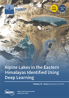
Alpine lakes are widely distributed in high mountain areas and are sensitive to climate and environmental changes. An automated alpine lake identification method was developed by leveraging deep learning algorithms and multi-source high-resolution satellite data. The method is capable of detecting the outlines and types of alpine lakes from high-resolution optical and SAR satellite data. A total of 4,584 alpine lakes were identified in the Eastern Himalayas by this method. The true-color satellite image presents typical alpine lakes in the Eastern Himalayas. Alpine lakes show up as dark blue or dark green colors. Glaciers are also visible in the image, located near the lakes and colored the brightest. The red-green-blue combination image was produced from the 10 m resolution bands acquired on January 5, 2023, by the MSI sensor onboard the ESA Sentinel-2B satellite. View this paper

  • Issues are regarded as officially published after their release is announced to the table of contents alert mailing list.
  • You may sign up for e-mail alerts to receive table of contents of newly released issues.
  • PDF is the official format for papers published in both, html and pdf forms. To view the papers in pdf format, click on the "PDF Full-text" link, and use the free Adobe Reader to open them.
Order results
Result details
Section
Select all
Export citation of selected articles as:
18 pages, 2445 KiB  
Review
Recent Advances in Bacterial Degradation of Hydrocarbons
by Emiliana Pandolfo, Anna Barra Caracciolo and Ludovica Rolando
Water 2023, 15(2), 375; https://doi.org/10.3390/w15020375 - 16 Jan 2023
Cited by 19 | Viewed by 8601
Abstract
Hydrocarbons occur in fossil fuels such as crude oil and consist mainly of hydrogen and carbon. Although they are natural chemicals, crude oil refining results in commercial products with new physico-chemical properties, which can increase their complexity and toxicity, and hamper their degradation. [...] Read more.
Hydrocarbons occur in fossil fuels such as crude oil and consist mainly of hydrogen and carbon. Although they are natural chemicals, crude oil refining results in commercial products with new physico-chemical properties, which can increase their complexity and toxicity, and hamper their degradation. The presence of biodiverse natural microbial communities is a prerequisite for an effective homeostatic response to the various hydrocarbons, that contaminate ecosystems. However, their removal depends on the compartment contaminated (water, sediment, soil), their molecular weight, and their toxicity not hampering microbial activity. This paper reports different bacterial species involved in the biodegradation of aliphatic and aromatic hydrocarbons. Hydrocarbon contamination is generally due to the co-presence of a mixture of these chemicals, and their removal from the environment cannot rely on only a single species but generally requires bacterial consortia. Versatile bacterial metabolism relies on specific genes encoding the key enzymes involved in the peripheral metabolic and central metabolic pathways for degrading aliphatic and polycyclic aromatic hydrocarbons. Although microbial metabolism can have the potential for natural attenuation of these contaminants, hydrocarbon bioremediation, through biostimulation (e.g., use of surfactants, plants, earthworms, and nanoparticles) and bioaugmentation, can be a valid tool for removing them from actually contaminated soil, freshwater, groundwater, and seawater. Full article
(This article belongs to the Section Soil and Water)
Show Figures

Figure 1

21 pages, 9908 KiB  
Article
Effect of Ecological Water Supplement on Groundwater Restoration in the Yongding River Based on Multi-Model Linkage
by Tian Nan and Wengeng Cao
Water 2023, 15(2), 374; https://doi.org/10.3390/w15020374 - 16 Jan 2023
Cited by 4 | Viewed by 2061
Abstract
Evaluating the effect of ecological water supplement on groundwater restoration quantitatively could produce positive contributions to both water cycle theory and surface–groundwater conjunctive management. Therefore, in this paper, a groundwater flow numerical model has been established after calculating the river section seepage rate [...] Read more.
Evaluating the effect of ecological water supplement on groundwater restoration quantitatively could produce positive contributions to both water cycle theory and surface–groundwater conjunctive management. Therefore, in this paper, a groundwater flow numerical model has been established after calculating the river section seepage rate using a fuzzy mathematical method in the Yongding River channel. The simulated results show that the model could accurately reflect the real groundwater dynamic features. Then, a data-driven random forest(RF) model has been established to quantitatively evaluate the contributions of the factors which influence the groundwater level variation. The Nash-Sutcliffe efficiency coefficient(NSE) of the RF model is 0.93. It shows excellent ability to identify the rising zone of groundwater level. The study shows that the infiltration capacity is strong in the upstream area of the Yongding River, and the seepage rate is over 0.7. The lowest seepage rate is 0.19 at the downstream end, while the seepage rate in the middle area is basically between 0.4 and 0.7. From 2018 to 2019, the ecological water supplement of the Yongding River has played a significant role in raising the groundwater level along the river channel. Additionally, its contribution analyzed by the RF model to the change of groundwater level is 25%. Groundwater exploitation is the most important variable affecting the groundwater level variation. The impact depth of groundwater level fluctuation reaches about 10 m. The impact range where the groundwater level average uplifts 1.86 m is 502.13 km2. The influence direction gradually changes from around the ecological water supplement section to along the Yongding River channel. The groundwater level variation along the tangential direction of the Yongding River is slowing down. The groundwater level would entirely uplift with 170 × 106 m3/year ecological water supplement of the Yongding River and 35.77 × 10⁶ m3/year groundwater mining reduction in the downstream area until 2035. Full article
(This article belongs to the Special Issue River Ecological Restoration and Groundwater Artificial Recharge II)
Show Figures

Figure 1

18 pages, 5152 KiB  
Article
Quantification of Evapotranspiration by Calculations and Measurements Using a Lysimeter
by Branislav Kandra, Andrej Tall, Milan Gomboš and Dana Pavelková
Water 2023, 15(2), 373; https://doi.org/10.3390/w15020373 - 16 Jan 2023
Cited by 7 | Viewed by 3447
Abstract
Evapotranspiration is one of the key elements of water balance in nature. It significantly influences the water supply in the unsaturated zone of a soil profile. The unsaturated zone is a water source for the biosphere. The aim of this study is to [...] Read more.
Evapotranspiration is one of the key elements of water balance in nature. It significantly influences the water supply in the unsaturated zone of a soil profile. The unsaturated zone is a water source for the biosphere. The aim of this study is to measure, calculate and analyze the course of actual evapotranspiration, precipitation and dew totals as well as the totals of water flows at the lower boundary of unsaturated zone and the change in water content in specified soil volume. The measurements are used for verifying the results of numerical simulation. The methods used in the study were chosen based on the hypothesis that dynamics of water supply changes in the unsaturated zone is the result of the interactions between atmosphere, soil and plant cover. The elements of water balance were quantified by the methods of water balance, lysimeter measurements and numerical simulation on the model HYDRUS-1D, version 4. The abovementioned parameters were quantified for the East Slovakian Lowland, with an hourly time step during the years 2017, 2018 and 2020. The measurements have shown that evapotranspiration exceeded precipitation during all monitored periods, specifically by 22% in 2017, by 14% in 2019, and by 10% in 2020. The deficit was compensated for by capillary inflow from the groundwater level and the water supply in the unsaturated zone. A verification by measurement has shown that numerical simulation is imprecise in relation to the quantification of water flows at the lower boundary of the unsaturated zone. This inaccuracy is manifested in the higher value of the actual evapotranspiration, which is on average exceeded by 11%. The performance of the mathematical model is assessed as satisfactory for the analysis of the soil water regime. Full article
(This article belongs to the Special Issue Advances in Sustainable Agriculture Progress under Climate Change)
Show Figures

Figure 1

12 pages, 1643 KiB  
Article
Duration, but Not Bottle Volume, Affects Phytoplankton Community Structure and Growth Rates in Microcosm Experiments
by Rita B. Domingues, Benjamin A. Mosley, Patrícia Nogueira, Inês B. Maia and Ana B. Barbosa
Water 2023, 15(2), 372; https://doi.org/10.3390/w15020372 - 16 Jan 2023
Cited by 2 | Viewed by 1669
Abstract
It is generally assumed that the larger the bottle volume, the longer the duration of phytoplankton microcosm experiments. We hypothesize that volume and duration are independent, as volume does not regulate the extension of the exponential growth phase. We conducted two microcosm experiments [...] Read more.
It is generally assumed that the larger the bottle volume, the longer the duration of phytoplankton microcosm experiments. We hypothesize that volume and duration are independent, as volume does not regulate the extension of the exponential growth phase. We conducted two microcosm experiments using 1, 2, and 8 L bottles, inoculated with phytoplankton collected in the Ria Formosa lagoon (SE Portugal) and incubated for 1, 2, 4, and 8 days. Phytoplankton net growth rates were estimated using chlorophyll a concentration and cell abundance, determined with epifluorescence and inverted microscopy. Results show that the experimental duration significantly affected net growth rates, independently of volume, with decreasing net growth rates with time. Regarding volume, we found significant, but weak, differences in net growth rates, and significant two-way interactions only for the larger-sized cells. No significant differences in net growth rates across the different volumes were detected for the smaller, most abundant taxa and for the whole assemblage. We conclude that duration, not volume, is the main factor to consider in microcosm experiments, and it should allow the measurement of responses during the exponential growth phase, which can be detected through daily sampling throughout the duration of the experiment. Full article
(This article belongs to the Special Issue Changing Phytoplankton Communities in Aquatic Environments)
Show Figures

Figure 1

14 pages, 1491 KiB  
Article
An Analysis of Factors Influencing Household Water, Sanitation, and Hygiene (WASH) Experiences during Flood Hazards in Tsholotsho District Using a Seemingly Unrelated Regression (SUR) Model
by Mlamuleli Tshuma, Johannes A. Belle and Alice Ncube
Water 2023, 15(2), 371; https://doi.org/10.3390/w15020371 - 16 Jan 2023
Cited by 1 | Viewed by 2928
Abstract
Communities around the world living in either urban or rural areas continue to experience serious WASH problems during flood episodes. Communities and individual households are affected differently depending on their coping capacities and their resource base. Flooding causes extensive damage to water and [...] Read more.
Communities around the world living in either urban or rural areas continue to experience serious WASH problems during flood episodes. Communities and individual households are affected differently depending on their coping capacities and their resource base. Flooding causes extensive damage to water and sanitation infrastructure, leaving communities vulnerable to WASH-related illnesses. This paper aimed to analyze factors influencing the community WASH experiences during flood incidences in Tsholotsho District using a Seemingly Unrelated Regression (SUR) model. The quantitative approach was used in this study. A questionnaire was used to collect data from household heads in Tsholotsho District. A total of 218 Questionnaires were administered in four wards that were purposively selected for this study. Gathered data were analyzed using the Statistical Package for Social Sciences (SPSS Version 22) and principal component analysis was done, which culminated in a SUR model. The key findings of the study were that outbreaks of water and hygiene-related diseases, ponding of water which provides a breeding ground for mosquitoes, and contamination of surface water were the major WASH problems experienced in Tsholotsho District among other problems. The study also found that access to Non-Governmental Organisations (NGOs) programs, access to treated water, and level of education were positive and statistically significant in influencing some of the problems experienced during flooding. To increase the coping capacities of Tsholotsho communities, it is pertinent for governments and NGOs to consider implementing more WASH programs, increasing access to safe and clean drinking water, and increasing the level of education of communities. Full article
Show Figures

Figure 1

19 pages, 6782 KiB  
Article
Patterns of Recent Changes in Channel Morphology and Flows in the Upper and Middle Odra River
by Ádám Nádudvari, Agnieszka Czajka, Bartłomiej Wyżga, Marcin Zygmunt and Marcin Wdowikowski
Water 2023, 15(2), 370; https://doi.org/10.3390/w15020370 - 16 Jan 2023
Cited by 7 | Viewed by 2371
Abstract
Our research introduces the river regulation effects on three sections of the upper and middle Odra River (south-western Poland), with differently channelized parts. In the upper and lower reaches, the river was straightened, narrowed, and trained with groins, whereas in the middle section, [...] Read more.
Our research introduces the river regulation effects on three sections of the upper and middle Odra River (south-western Poland), with differently channelized parts. In the upper and lower reaches, the river was straightened, narrowed, and trained with groins, whereas in the middle section, it was also impounded by numerous barrages. The discharge duration (DD) and water stage duration (WSD) curves for water-gauge stations from these river sections were analyzed to recognize changes in river flows and channel morphology since the mid-20th century. This analysis is supplemented by an examination of repeated surveys of the gauge cross sections of the river, annual precipitation totals in its catchment, and their relationship to the variation of the North Atlantic Oscillation (NAO) index. Our findings provide new hydrological insights for the region. The three river sections exhibited different patterns of the adjustment of the channel morphology to the river channelization: upper section was typified by channel incision, middle section by channel stability, and lower section by channel incision in its upper part and vertical stability of the channel bed in the lower part. Barrages in the middle section stabilized water stages in a wide range of hydrological conditions. Annual precipitation totals and river run-off did not change systematically over the study period. The variation in precipitation totals was inversely related to annual values of the NAO index. The study confirms the usefulness of DD/WSD curves to analyze changes in river run-off and the vertical position of the channel bed. Full article
Show Figures

Figure 1

17 pages, 3916 KiB  
Article
Effect of Using a Passive Rotor on the Accuracy of Flow Measurements in Sewer Pipes Using a Slug Tracer-Dilution Method
by Neveen B. Abdel-Mageed, Ashraf Ghanem, Ibrahim G. Shaaban, Atiyeh Ardakanian, Mohamed M. M. Ibrahem and Mohamed Elgamal
Water 2023, 15(2), 369; https://doi.org/10.3390/w15020369 - 16 Jan 2023
Cited by 1 | Viewed by 1594
Abstract
Flow measurements in pipelines using slug tracer have proved highly accurate for turbulent flow. This study experimentally investigates the effectiveness of using a passive rotor on the accuracy of discharge measurements in sewer pipes based on a saline slug tracer technique. For this [...] Read more.
Flow measurements in pipelines using slug tracer have proved highly accurate for turbulent flow. This study experimentally investigates the effectiveness of using a passive rotor on the accuracy of discharge measurements in sewer pipes based on a saline slug tracer technique. For this purpose, a saline injector stack was developed to help inject saline at selected injection points. A passive axial flow rotor was also proposed and encased in the injector stack to enhance the mixing of injected tracer with the transmitted downstream flow and to decrease the required minimum mixing length. It was found that adding the passive rotor significantly increased the accuracy of the flow measurements. Two tracer flow formulas were developed: one based on the dimensional analysis approach and the other based on a semi-empirical formula obtained from the mass conservation approach. The resultant formulas compared favourably with flow metering, especially when utilizing the passive fan unit. Full article
(This article belongs to the Section Urban Water Management)
Show Figures

Figure 1

21 pages, 2297 KiB  
Article
Theoretical Estimation of Disinfectant Mass Balance Components in Drinking Water Distribution Systems
by Kittikun Wongpeerak, Natchapol Charuwimolkul, Jiramate Changklom, Surachai Lipiwattanakarn and Adichai Pornprommin
Water 2023, 15(2), 368; https://doi.org/10.3390/w15020368 - 16 Jan 2023
Viewed by 1987
Abstract
The water quality audit concept is an important feature in assessing the loss of disinfectant mass in drinking water distribution systems. Based on this concept, the loss can be divided into the loss of disinfectant mass through water losses (Ml) [...] Read more.
The water quality audit concept is an important feature in assessing the loss of disinfectant mass in drinking water distribution systems. Based on this concept, the loss can be divided into the loss of disinfectant mass through water losses (Ml) and the decay of disinfectant mass due to chemical reactions (Mr). When an audit focuses on the effect of water losses on the loss of disinfectant mass, the decay of disinfectant mass by chemical reactions with the ideal condition of no water losses (Mro) has to be estimated; thus, the disinfectant mass associated with water losses (MWL=Ml+MrMro) can be assessed. Generally, the computation of these components (Ml, Mr, and MWL) needs hydraulic and water quality modeling. In this study, we propose a novel method based on a simple theoretical analysis to evaluate these components using only two parameters: the ratio of water losses (p) and the ratio of disinfectant concentrations at the critical pressure point and the network inlet (Cp*). The coefficients of our theoretical Ml, Mr, and MWL were estimated using 20 real network models, with p between 2.8% and 54.9% and Cp* between 18.4% and 91.9%. The results showed that our equations were effective at assessing the loss of disinfectant mass in drinking water distribution networks for the top-down auditing approach. Full article
(This article belongs to the Section Urban Water Management)
Show Figures

Figure 1

21 pages, 1334 KiB  
Review
A Comprehensive Review of the Multiple Uses of Water in Aquaculture-Integrated Agriculture Based on International and National Experiences
by Lubna A. Ibrahim, Mohamed Abu-Hashim, Hiba Shaghaleh, Elsayed Elsadek, Amar Ali Adam Hamad and Yousef Alhaj Hamoud
Water 2023, 15(2), 367; https://doi.org/10.3390/w15020367 - 16 Jan 2023
Cited by 13 | Viewed by 5232
Abstract
Multiple uses of water aquaculture-integrated agriculture systems (AIAS) are inevitable to produce more food per drop of water to address water shortage, food insecurity, and climate change. This survey intends to outline the multiple-use water in pond-based AIAS in light of legal regulations [...] Read more.
Multiple uses of water aquaculture-integrated agriculture systems (AIAS) are inevitable to produce more food per drop of water to address water shortage, food insecurity, and climate change. This survey intends to outline the multiple-use water in pond-based AIAS in light of legal regulations and water salinity. Scenarios for pond-based AIA and their impact on the environment were presented and discussed. Pond-based AIA has been demonstrated to have many social, economic, and environmental benefits. Moreover, international and national experiences and attempts for genuine applications were exhibited. Throughout, pond-based AIA farming practices are seen as a proficient utilization of water that aids food sustainability. It was concluded that pond-based AIA could aid in increasing productivity, income for food producers and soil fertility, ecosystem maintenance, and adaptation to environmental change. AIAS helps adapt to and mitigate climate change by reducing waste and greenhouse gas emissions, reducing pressure on water resources, and recycling nutrients. Finally, developing and promoting the expansion of rotation of wheat-fish and pond-based AIA in the desert and encouraging global collaboration for information and knowledge transfer among different countries were discussed. Full article
(This article belongs to the Special Issue Improved Irrigation Management Practices in Crop Production)
Show Figures

Figure 1

25 pages, 11931 KiB  
Article
Optimum Coastal Slopes Exposed to Waves: Experimental and Numerical Study
by Reza Zandi, Khosro Lari and Mohammad Najafzadeh
Water 2023, 15(2), 366; https://doi.org/10.3390/w15020366 - 16 Jan 2023
Viewed by 1954
Abstract
In this research, experimental and numerical studies of water waves in a wave tank are analyzed and how to find the optimum beach slope for numerical simulation is also investigated. First, with the aid of a wave tank (flap type), waves with different [...] Read more.
In this research, experimental and numerical studies of water waves in a wave tank are analyzed and how to find the optimum beach slope for numerical simulation is also investigated. First, with the aid of a wave tank (flap type), waves with different wave amplitudes are created in the laboratory, and data of generated waves are measured by different wave probes. Then, numerical simulations of the wave tank and waves with different wave amplitudes are performed in Ansys Fluent industrial software. The VOF method is used to model two-phase flow. The results of experimental and numerical simulations are compared and examined. Moreover, the effects of the beach slope on the simulation are analyzed and compared with the experimental results to obtain the best slope. The results show that the numerical simulation, by using the appropriate beach slope, can properly model the experimental results with a low CPU time. Additionally, the 1:5 beach slope is considered the best slope that can dampen the energy of the waves and prevent their reflection. Full article
(This article belongs to the Special Issue Erosion and Sediment Transport Processes in Coastal Waters)
Show Figures

Figure 1

35 pages, 23681 KiB  
Article
Decision Support System for Sustainable Exploitation of the Eocene Aquifer in the West Bank, Palestine
by Andreja Jonoski, Tanvir Ahmed, Mohammad N. Almasri and Muath Abu-Saadah
Water 2023, 15(2), 365; https://doi.org/10.3390/w15020365 - 16 Jan 2023
Cited by 2 | Viewed by 1979
Abstract
Groundwater is a crucial resource for water supply and irrigation in many parts of the world, especially in the Middle East. The Eocene aquifer, located in the northern part of the West Bank, Palestine, is threatened by unsustainable groundwater abstractions and on-ground pollution. [...] Read more.
Groundwater is a crucial resource for water supply and irrigation in many parts of the world, especially in the Middle East. The Eocene aquifer, located in the northern part of the West Bank, Palestine, is threatened by unsustainable groundwater abstractions and on-ground pollution. Analysis and management of this aquifer are challenging because of limited data availability. This research contributes to the long-term sustainability of the aquifer by model-based design of future abstraction strategies considered within an uncertainty analysis framework. The methodology employed started with development of a single-layer steady-state MODFLOW groundwater model of the area, followed by uncertainty analysis of model parameters using Monte Carlo simulations. The same model was afterwards coupled with a Successive Linear Programming (SLP) optimization algorithm, implemented in the Groundwater Management tool (GWM) of the United States Geological Survey (USGS). The purpose of optimization was deriving five optimal abstraction strategies, each aiming to maximize groundwater abstraction, subject to different constraints regarding groundwater depletion. Given the uncertainty of model parameters, the sensitivity and reliability of these optimal strategies were then tested. Sensitivity was checked for two optimal strategies by performing re-optimization with different values of uncertain model parameters (one at a time). Reliability of the five strategies was tested by analyzing the extent of constraints’ violation for each strategy when varying the uncertain parameters using Monte Carlo simulations. Finally, the model was used for determining capture zones of wells for the five optimal abstraction strategies, land-use in these capture zones, and the associated estimates of on-ground nitrogen loading. The developed strategies were then deployed in a web-based decision support application (named Groundwater Decision Support System—GDSS), together with other relevant information. Users can analyze results of different optimal strategies in terms of groundwater level variations and total water balance results, and test consequences of uncertain parameters. Capture zones of wells for different abstraction strategies, together with land-use and on-ground nitrogen loading in these capture zones, are also presented. Results show that critical uncertain parameters are recharge, hydraulic conductivity, and conductance at key boundary condition locations. Optimal abstraction strategies results indicate that an increase in total abstractions could be between 5% and 20% from the current level (estimated at about 56 × 106 m3/year, which is about 74% of estimated annual recharge). The uncertain parameters, however, are impacting the sensitivity and the reliability of the optimal strategies to variable degrees. Recharge and hydraulic conductivity are the most critical uncertain parameters regarding sensitivity of the optimal strategies, while reliability is also impacted by the level of abstraction proposed in a given strategy (number, locations, and abstraction rates of new wells). The main novelty and contribution of this research is in combining modelling, uncertainty analysis, and optimization techniques in a comprehensive decision support system for the area of the Eocene aquifer, characterized with limited data availability. Full article
(This article belongs to the Special Issue Groundwater Management in a Changing World: Challenges and Endeavors)
Show Figures

Figure 1

14 pages, 5768 KiB  
Article
Extending the Overlay and Index: A Simple Method for Assessing Aquifer Vulnerability in a Combined Vadose Zone—Groundwater Flow System
by Aldo Fiori, Irene Pomarico, Antonio Zarlenga, Vittorio Catani and Guido Leone
Water 2023, 15(2), 364; https://doi.org/10.3390/w15020364 - 16 Jan 2023
Cited by 1 | Viewed by 1537
Abstract
This work extends the overlay and index methods for intrinsic groundwater vulnerability, that typically involve the soil surface and the vadose zone, to groundwater (saturated) transport. The method is “hybrid” as it combines the standard overlay and index methods with a simplified process-based [...] Read more.
This work extends the overlay and index methods for intrinsic groundwater vulnerability, that typically involve the soil surface and the vadose zone, to groundwater (saturated) transport. The method is “hybrid” as it combines the standard overlay and index methods with a simplified process-based approach for the groundwater component. For the latter, we make use of concept and methodologies based on geomorphological analysis, employing tools that are generally implemented in Geographic Information Systems (GIS). The proposed method is based on a simple probabilistic analysis, in which the overlay and index method (that can be any) provides the probability that the contamination reaches the groundwater through the vadose zone, while the probability that the contaminant reaches a generic location in the groundwater system is determined by analyzing the groundwater streamlines. The analysis leads to the definition of the combined vulnerability index υ, that takes care of both transport in the vadose zone and the aquifer. The method is applied to a groundwater catchment in the Campania region, Southern Italy. The method is simple and effective in assessing aquifer vulnerability in a combined vadose zone—groundwater flow system, useful for preliminary, screening analysis of the intrinsic aquifer vulnerability. Full article
(This article belongs to the Section Hydrogeology)
Show Figures

Figure 1

13 pages, 1523 KiB  
Article
Analysis of the Infiltration and Water Storage Performance of Recycled Brick Mix Aggregates in Sponge City Construction
by Bowen Qi, Peilong Xu and Chengzhao Wu
Water 2023, 15(2), 363; https://doi.org/10.3390/w15020363 - 16 Jan 2023
Cited by 20 | Viewed by 2237
Abstract
With the gradual advancement of urbanization, urban hardened roofs and pavements are increasing, and the rainwater cycle is being seriously damaged; sponge city construction has become an inevitable trend to address this problem. The analysis of the infiltration and storage performance of recycled [...] Read more.
With the gradual advancement of urbanization, urban hardened roofs and pavements are increasing, and the rainwater cycle is being seriously damaged; sponge city construction has become an inevitable trend to address this problem. The analysis of the infiltration and storage performance of recycled brick aggregate, which is highly absorbent and can be used as a permeable paving material in sponge cities, is of great significance. The study firstly designed a simulated rainfall test device, then carried out tests in terms of aggregate gradation, aggregate type, and aggregate grade, and finally analyzed its effect on the void structure and infiltration and water storage performance of recycled brick mix aggregates. The outcomes demonstrate that the particle size of recycled brick concrete aggregate is positively related to the water storage capacity, and the volume water storage rate of recycled sand is close to 26%. The fitting result of 1 h water storage rate under different dosage is 0.984. After 1 h of rainfall, the water storage rate is 3 times that of natural aggregate, and the volume water absorption rate is 2.5 times that of natural aggregate. This indicates that recycled brick concrete aggregate has strong permeability and water storage properties and has great potential for application in sponge city construction, and the study provides a reference for the optimal design of subsequent cities. Full article
Show Figures

Figure 1

12 pages, 11408 KiB  
Article
Investigation on Water Levels for Cascaded Hydropower Reservoirs to Drawdown at the End of Dry Seasons
by Shuangquan Liu, Xuhan Luo, Hao Zheng, Congtong Zhang, Youxiang Wang, Kai Chen and Jinwen Wang
Water 2023, 15(2), 362; https://doi.org/10.3390/w15020362 - 16 Jan 2023
Cited by 2 | Viewed by 1550
Abstract
Operators often have a dilemma in deciding what water levels the over-year hydropower reservoirs should drawdown at the end of dry seasons, either too high to achieve a large firm hydropower output during the dry seasons in the current year and minor spillage [...] Read more.
Operators often have a dilemma in deciding what water levels the over-year hydropower reservoirs should drawdown at the end of dry seasons, either too high to achieve a large firm hydropower output during the dry seasons in the current year and minor spillage in coming flood seasons, or too low to refill to the full storage capacity at the end of the flood seasons and a greater firm hydropower output in the coming year. This work formulates a third-monthly (in an interval of about ten days) hydropower scheduling model, which is linearized by linearly concaving the nonlinear functions and presents a rolling strategy to simulate many years of reservoir operations to investigate how the water level at the end of dry seasons will impact the performances, including the energy production, firm hydropower output, full-refilling rate, etc. Applied to 11 cascaded hydropower reservoirs in a river in southwest China, the simulation reveals that targeting a drawdown water level between 1185–1214 m for one of its major over-year reservoirs and 774–791 m for another is the most favorable option for generating more hydropower and yielding larger firm hydropower output. Full article
(This article belongs to the Section Hydrology)
Show Figures

Figure 1

12 pages, 2367 KiB  
Article
Sustainable Water Treatment with Induced Bank Filtration
by Miles Schelling, Kavita Patil and Thomas B. Boving
Water 2023, 15(2), 361; https://doi.org/10.3390/w15020361 - 16 Jan 2023
Cited by 1 | Viewed by 2816
Abstract
This study demonstrates that an induced bank filter (IBF) system can treat raw water polluted with Escherichia coli (E. coli) bacteria. Similar to riverbank filtration (RBF), induced or reversed bank filtration relies on natural processes to clean water, including filtration through [...] Read more.
This study demonstrates that an induced bank filter (IBF) system can treat raw water polluted with Escherichia coli (E. coli) bacteria. Similar to riverbank filtration (RBF), induced or reversed bank filtration relies on natural processes to clean water, including filtration through layers of allochthone alluvial sediments and a bioactive layer that forms on top of the filter after a ripening period. At the study site, located in Southwestern India, villagers rely on a mountain spring for their water supply. Although of generally high quality, the spring water contains E. coli bacteria (up to ~2000 MPN/100 mL). Raw water diverted from this spring was gravity-fed into the IBF system, which consisted of a (1) flow regulator, (2) pre-filter and (3) the actual IBF filter. Designed and constructed based on pilot testing of prototype filters, a full-scale filter (5 m by 7 m by 2 m) was built and its performance and maintenance requirements were studied during both the monsoon season and the dry season. The data show that the IBF significantly improved the water quality. Turbidity and E. coli concentrations were reduced to or below the detection limit (approximately 2.5 log unit reduction). During the peak of the monsoon season (August), E. coli was present in the IBF effluent after a storm destroyed the cover of the IBF tank. The IBF construction and maintenance costs were documented. Extrapolated over a 10-year period, the cost of IBF water was 3 and 10 times lower than reverse osmosis or water supplied by truck, respectively. This study demonstrates that IBF can be part of an affordable water supply system for rural villages in mountainous terrain where conventional RBF systems cannot be installed or where other water treatment technologies are out of financial reach. Full article
(This article belongs to the Section Wastewater Treatment and Reuse)
Show Figures

Figure 1

19 pages, 11005 KiB  
Article
Multi-Site Calibration of Hydrological Model and Spatio-Temporal Assessment of Water Balance in a Monsoon Watershed
by Agbortoko Bate Ashu and Sang-Il Lee
Water 2023, 15(2), 360; https://doi.org/10.3390/w15020360 - 15 Jan 2023
Cited by 2 | Viewed by 2044
Abstract
Understanding hydrological processes using hydrological model parameters can improve the management of water resources in a watershed. This research uses the Soil and Water Assessment Tool (SWAT) model in examining the water balance in the Yeongsan River Basin, South Korea. Summer monsoon dominates [...] Read more.
Understanding hydrological processes using hydrological model parameters can improve the management of water resources in a watershed. This research uses the Soil and Water Assessment Tool (SWAT) model in examining the water balance in the Yeongsan River Basin, South Korea. Summer monsoon dominates the region, accounting for about 60–70% of the rain between June to September. The basin is facing significant challenges in water management due to the limited availability of water and the high demand for agricultural water due to the construction of two weirs on the river. To this end, a new multi-site calibration approach-based SWAT hydrological model that can accurately reproduce the hydrological trend and average discharges of the Yeongsan basin for 42 years (1980–2021) was developed. Some statistical matrices (such as Nash–Sutcliffe model efficiency) were utilized in calibrating and validating the model. Results show that the performance indicators for the four investigated stream flow stations were satisfactory. In addition, the water balance study revealed that the highest precipitation and evapotranspiration occurred in August, whereas the highest water yield, lateral flow, and surface flow occurred in July. Further, the model revealed that the Yeongsan river basin receives the majority of its water from the rains during the monsoon season. The model developed in this study can aid planners in managing water resources in the Yeongsan river basin. Full article
(This article belongs to the Section Hydrology)
Show Figures

Figure 1

20 pages, 8031 KiB  
Article
Hydrogeochemical Characteristics, Water Quality, and Human Health Risks of Groundwater in Wulian, North China
by Min Wang, Wenxiu Zhang, Peng Yang, Jianguo Feng, Ruilin Zhang, Zongjun Gao, Hongjie Jin, Xiaoyu Song and Xiaobing Gao
Water 2023, 15(2), 359; https://doi.org/10.3390/w15020359 - 15 Jan 2023
Cited by 5 | Viewed by 2002
Abstract
Groundwater shortage and pollution are critical issues of global concern. In Wulian County, a typical hilly area, groundwater is the main source of water supply. This study investigates the current situation of groundwater pollution in Wulian City through the analysis of groundwater water [...] Read more.
Groundwater shortage and pollution are critical issues of global concern. In Wulian County, a typical hilly area, groundwater is the main source of water supply. This study investigates the current situation of groundwater pollution in Wulian City through the analysis of groundwater water chemistry characteristics, water quality evaluation, and health risk evaluation. After the analysis of the controlling factors of chemical components in groundwater and the analysis of ion sources, the main ion sources in groundwater were determined. The results showed that the major cations in groundwater were Ca2+ and Na+ and the major anions were HCO3 and SO42−. Nevertheless, NO3 exceeded the standard to different degrees in pore water (PW), fissure pore water (FPW), and fissure water (FW). The minimum NO3 concentration exceeded the standard in FW. Under the influence of rock weathering and salt rock dissolution, the main hydrochemical types of groundwater were the HCO3-Ca, HCO3-Ca·Mg, and SO4·Cl-Ca·Mg types. According to the water quality evaluation and health risk assessment, the FW area in the south had the highest water quality, where Class I water appeared and potable water was more widely distributed. The PW and FPW areas in the north had lower water quality, with higher health risks. Category V water gradually appeared in the FPW area, which is not suitable as a water supply source. Factor analysis and ion ratio analysis showed that the study area is strongly affected by anthropogenic factors. These research methods have important reference value to the research of groundwater pollution status. Full article
(This article belongs to the Topic Human Impact on Groundwater Environment)
Show Figures

Figure 1

20 pages, 3361 KiB  
Article
The Dynamics of Hydrological Extremes under the Highest Emission Climate Change Scenario in the Headwater Catchments of the Upper Blue Nile Basin, Ethiopia
by Gashaw Gismu Chakilu, Szegedi Sándor and Túri Zoltán
Water 2023, 15(2), 358; https://doi.org/10.3390/w15020358 - 15 Jan 2023
Cited by 2 | Viewed by 1798
Abstract
Climate change and its impact on surface runoff in the upper Blue Nile basin and sub-basins have been widely studied in future climate projections. However, the impact on extreme flow events of rivers is barely investigated discretely. In this paper, the change in [...] Read more.
Climate change and its impact on surface runoff in the upper Blue Nile basin and sub-basins have been widely studied in future climate projections. However, the impact on extreme flow events of rivers is barely investigated discretely. In this paper, the change in temperature and rainfall under the Representative Concentration Pathway (RCP) highest emission scenario (RCP 8.5) and its impact on the high flow and low flow simulated by the Soil and Water Assessment Tool (SWAT 2012) in major watersheds of the Lake Tana Basin has been evaluated by comparing the baseline period (1971–2000) with the 2020s (2011–2040), 2050s (2041–2070), and 2080s (2071–2100). The high flows of watersheds were selected by the Annual Maximum Series (AMS) model, whereas the low-flow watersheds were selected by the 7-day sustained mean annual minimum flow method. The result showed that the highest change in maximum temperature ranged from 2.93 °C to 5.17 °C in monthly time scales in the 2080s. The increment in minimum temperature is also more prominent in the 2080s and it is expected to rise by 4.75 °C. Inter-annual variability of the change in rainfall has shown increasing and decreasing patterns. The highest increments are expected by 22.37%, 25.58%, and 29.75% in the 2020s, 2050s, and 2080s, respectively, whereas the projected highest decrease in rainfall dictates the decrease of 6.42%, 7.11%, and 9.26% in 2020s, 2050s, and 2080s, respectively. Due to changes in temperature and rainfall, the low flow is likely to decrease by 8.39%, 8.33%, 6.21%, and 5.02% in Ribb, Gumara, Megech, and Gilgel Abay watersheds, respectively, whereas the high flow of Gilgel Abay, Megech, Gumara, and Ribb watersheds are expected to increase by 13.94%, 12.16%, 10.90%, and 10.24%, respectively, every 30 years. Full article
Show Figures

Graphical abstract

17 pages, 5004 KiB  
Article
Temporal Variation and Spatial Distribution of Groundwater Level Changes Induced by Large Earthquakes
by Ching-Yi Liu, Yeeping Chia, Po-Yu Chung, Tsai-Ping Lee and Yung-Chia Chiu
Water 2023, 15(2), 357; https://doi.org/10.3390/w15020357 - 15 Jan 2023
Cited by 1 | Viewed by 1832
Abstract
Sustained coseismic changes in groundwater level due to static strain during earthquakes could be considered as an indicator of crustal deformation. These changes usually occur abruptly but recover slowly after earthquakes. High-frequency data indicate a time lag between the coseismic change of well [...] Read more.
Sustained coseismic changes in groundwater level due to static strain during earthquakes could be considered as an indicator of crustal deformation. These changes usually occur abruptly but recover slowly after earthquakes. High-frequency data indicate a time lag between the coseismic change of well water levels and that of the groundwater levels in the aquifer. Abnormal post-seismic changes in groundwater level were observed, possibly caused by cross-formation flow, fracturing, or strain relief. Although sustained changes are generally induced by a local earthquake, they could also be triggered by a distant large earthquake that has occurred at the same tectonic plate. The magnitude and polarity of coseismic changes may vary in wells of different depths at multiple-well stations, revealing additional information about the complexity of crustal deformation in the subsurface. Coseismic falls dominated near the ruptured seismogenic fault during the 1999 M7.6 earthquake, which implied crustal extension adjacent to the thrust fault. However, coseismic rises prevail in most areas, suggesting that crustal compression caused by plate convergence plays a major role on the island of Taiwan during earthquakes. Full article
Show Figures

Figure 1

11 pages, 1682 KiB  
Article
Hydrogeological Parameter Estimation of Confined Aquifer within a Rectangular Shaped Drop Waterproof Curtain
by Yi Li, Wentao Xie, Hongwei Wang, Bin Peng, Feng Xiong and Chun Zhu
Water 2023, 15(2), 356; https://doi.org/10.3390/w15020356 - 15 Jan 2023
Viewed by 1664
Abstract
For the dewatering of deep excavation, the existing man-made waterproof curtain has a significant influence on flow response in confined aquifers; the effect of the waterproof curtain must be considered when using the field data for hydrogeological parameter estimation. In this study, a [...] Read more.
For the dewatering of deep excavation, the existing man-made waterproof curtain has a significant influence on flow response in confined aquifers; the effect of the waterproof curtain must be considered when using the field data for hydrogeological parameter estimation. In this study, a closed-form analytical solution for constant discharge pumping in a confined aquifer within a rectangular-shaped drop waterproof curtain is obtained by making use of the image method coupled with the superpose principle. A straight-lined method is presented to determine the value of the hydraulic parameters of the confined aquifer and the application of the obtained results is illustrated by the usefulness of a field pumping test in Wuhan, China. The results show that the predicted drawdowns developed by the estimated parameters are in good agreement with the measured drawdown in the field. The proposed solution and parameter estimation are reliable and can provide important help for the design of dewatering in deep foundation pit engineering. Full article
Show Figures

Figure 1

17 pages, 1806 KiB  
Article
Ecological Health Assessment with the Combination Weight Method for the River Reach after the Retirement and Renovation of Small Hydropower Stations
by Feng Cai, Zhinan Hu, Beihan Jiang, Weifang Ruan, Shujuan Cai and Huiling Zou
Water 2023, 15(2), 355; https://doi.org/10.3390/w15020355 - 14 Jan 2023
Cited by 2 | Viewed by 1770
Abstract
This study aimed to effectively evaluate the ecological restoration of the river reach where a small hydropower station was retired or renovated. An ecological health index system was constructed based on the environmental characteristics of the upstream and downstream of the small hydropower [...] Read more.
This study aimed to effectively evaluate the ecological restoration of the river reach where a small hydropower station was retired or renovated. An ecological health index system was constructed based on the environmental characteristics of the upstream and downstream of the small hydropower station after its retirement and renovation. Based on the combination weighting concept of game theory, the combination weights were obtained by the comprehensive analytic hierarchy process (subjective weight) and entropy method (objective weight). This ecological health assessment with fuzzy comprehensive evaluation was applied to assess the health status of Shimen (dam removal) and Changqiao (renovation in ecological flow) reaches of the Tufang River in Changting County, China. The results showed that the ecological health assessment index system proposed in this study was comprehensive and reasonable, and the revision degree of the hydropower station obviously influenced the process of ecological river restoration. The findings from this study would benefit for the rational utilization of water resources and the river ecological health maintenance in mountainous areas. Full article
Show Figures

Figure 1

17 pages, 25363 KiB  
Article
Retrieving Eutrophic Water in Highly Urbanized Area Coupling UAV Multispectral Data and Machine Learning Algorithms
by Di Wu, Jie Jiang, Fangyi Wang, Yunru Luo, Xiangdong Lei, Chengguang Lai, Xushu Wu and Menghua Xu
Water 2023, 15(2), 354; https://doi.org/10.3390/w15020354 - 14 Jan 2023
Cited by 3 | Viewed by 1845
Abstract
With the rapid development of urbanization and a population surge, the drawback of water pollution, especially eutrophication, poses a severe threat to ecosystem as well as human well-being. Timely monitoring the variations of water quality is a precedent to preventing the occurrence of [...] Read more.
With the rapid development of urbanization and a population surge, the drawback of water pollution, especially eutrophication, poses a severe threat to ecosystem as well as human well-being. Timely monitoring the variations of water quality is a precedent to preventing the occurrence of eutrophication. Traditional monitoring methods (station monitoring or satellite remote sensing), however, fail to real-time obtain water quality in an accurate and economical way. In this study, an unmanned aerial vehicle (UAV) with a multispectral camera is used to acquire the refined remote sensing data of water bodies. Meanwhile, in situ measurement and sampling in-lab testing are carried out to obtain the observed values of four water quality parameters; subsequently, the comprehensive trophic level index (TLI) is calculated. Then three machine learning algorithms (i.e., Extreme Gradient Boosting (XGB), Random Forest (RF) and Artificial Neural Network (ANN)) are applied to construct the inversion model for water quality estimation. The measured values of water quality showed that the trophic status of the study area was mesotrophic or light eutrophic, which was consistent with the government’s water-control ambition. Among the four water quality parameters, TN had the highest correlation (r = 0.81, p = 0.001) with TLI, indicating that the variation in TLI was inextricably linked to TN. The performances of the three models were satisfactory, among which XGB was considered the optimal model with the best accuracy validation metrics (R2 = 0.83, RMSE = 0.52). The spatial distribution map of water quality drawn by the XGB model was in good agreement with the actual situation, manifesting the spatial applicability of the XGB model inversion. The research helps guide effective monitoring and the development of timely warning for eutrophication. Full article
(This article belongs to the Special Issue Application of AI and UAV Techniques in Urban Water Science)
Show Figures

Figure 1

16 pages, 1654 KiB  
Review
Methods of Removal of Hormones in Wastewater
by Daniela Guerrero-Gualan, Eduardo Valdez-Castillo, Tania Crisanto-Perrazo and Theofilos Toulkeridis
Water 2023, 15(2), 353; https://doi.org/10.3390/w15020353 - 14 Jan 2023
Cited by 4 | Viewed by 5654
Abstract
Hormones are a type of emerging contaminant that reach the aquatic environment through wastewater effluents and which wastewater treatment plants (WWTP) cannot eliminate. The objective of this article was to determine the best hormone abatement technique between algae and microalgae, rotating biological discs, [...] Read more.
Hormones are a type of emerging contaminant that reach the aquatic environment through wastewater effluents and which wastewater treatment plants (WWTP) cannot eliminate. The objective of this article was to determine the best hormone abatement technique between algae and microalgae, rotating biological discs, organic adsorbents, and activated carbon. For this, a critical review of the behavior of the abatement methods was conducted in the existing bibliographical scientific databases over the last eight years. Then, the Modified Saaty method was applied, establishing a relationship between removal efficiency, removal time, maintenance costs, stage of development, and environmental impact in each technique studied by a panel of experts, who weighted the chosen variables on a scale of 1–9 according to the variable’s importance. The results indicated that the best technique to abate hormones is one that uses organic adsorbents and which reached a final comparative value of 0.58/1, which indicates the suitability of the method to combine the five comparison variables. At the same time, the rotating biological disc technique reached a value of 0.17/1, indicating its deficiency in the balance between the analyzed variables. Full article
(This article belongs to the Section Wastewater Treatment and Reuse)
Show Figures

Figure 1

14 pages, 4863 KiB  
Article
Analysing the Reciprocity Law for UV-LEDs in Water Disinfection of Escherichia coli, Enterococcus faecalis, and Clostridium perfringens
by Ahmed Kamel, Ana Palacios, Manuel Fuentes and Marta Vivar
Water 2023, 15(2), 352; https://doi.org/10.3390/w15020352 - 14 Jan 2023
Cited by 2 | Viewed by 2209
Abstract
The aim of this study is to verify the reciprocity law in the wastewater disinfection process using UV light. The optical power UV-LEDs used were 1.6 mW and 50 mW, and the wavelengths were 265 nm and 275 nm. E. coli, Enterococcus [...] Read more.
The aim of this study is to verify the reciprocity law in the wastewater disinfection process using UV light. The optical power UV-LEDs used were 1.6 mW and 50 mW, and the wavelengths were 265 nm and 275 nm. E. coli, Enterococcus faecalis, and Clostridium perfringens were the three microorganisms analysed in the study. The results showed lower inactivation rates around 0.063–0.065 cm2/mJ for 265 nm and 0.047–0.049 cm2/mJ for 275 nm for the Clostridium perfringens compared with the other two bacteria. For E. coli and Enterococcus faecalis, the inactivation rate was almost identical; 0.28 and 0.21 cm2/mJ, respectively, using 265 nm wavelength. There was a slightly better inactivation performance using the medium-power 275 nm UV-LEDs of 0.39 cm2/mJ and 0.29 cm2/mJ for E. coli and Enterococcus faecalis, respectively, and 0.33 cm2/mJ and 0.26 cm2/mJ using the low-power 275 nm UV-LEDs. The analysed data justify the reciprocity law for UV-LEDs disinfection using 265 nm and 275 nm UV-LEDs with two optical powers of 1.6 mW and 50 mW. Full article
(This article belongs to the Special Issue Advances in UV Water and Wastewater Treatment Technology)
Show Figures

Figure 1

10 pages, 9058 KiB  
Article
Effect of the Pulsed Addition of Phosphorous on the Growth and Toxin Production of the Bloom-Forming Cyanobacterium Chrysosporum ovalisporum (Forti) Zapomelová et al.
by Sicheng Yin, Ruohan Huang, Ni Wang, Changxing Li, Erik Jeppesen, Liqing Wang and Wei Zhang
Water 2023, 15(2), 351; https://doi.org/10.3390/w15020351 - 14 Jan 2023
Cited by 1 | Viewed by 1385
Abstract
Eutrophication and global warming boost the outbreak of cyanobacterial blooms and the spread of invasive cyanobacterial species such as Chrysosporum ovalisporum. Different from the often steady-state conditions under laboratory cultivation, the external input of nutrients in natural water is often intermittent and [...] Read more.
Eutrophication and global warming boost the outbreak of cyanobacterial blooms and the spread of invasive cyanobacterial species such as Chrysosporum ovalisporum. Different from the often steady-state conditions under laboratory cultivation, the external input of nutrients in natural water is often intermittent and pulsed, which may affect the response of cyanobacteria. In this study, we cultured C. ovalisporum under two phosphorus treatment patterns: a one-time treatment and a five-time pulsed treatment with the same total dosing. Our results showed that phosphorus deficiency in the water inhibits the growth of C. ovalisporum, thereby significantly reducing its biomass and photosynthetic activity (p < 0.05). In addition, phosphorus deficiency led C. ovalisporum to secrete more exopolysaccharides and alkaline phosphatase. Compared with the one-time treatment, the multiple pulses promoted the absorption of phosphorus by C. ovalisporum and inhibited the synthesis of alkaline phosphatase but had no significant effect on the release of cylindrospermopsin (CYN). We also found that multiple pulses had a more significant growth-promoting effect on C. ovalisporum under low phosphorus concentrations. Our results indicated the overall strong adaptability of C. ovalisporum to dynamic changes in phosphate levels in the water column and provide new insight into the outbreak and dispersal strategies of C. ovalisporum. Full article
(This article belongs to the Section Biodiversity and Functionality of Aquatic Ecosystems)
Show Figures

Figure 1

16 pages, 3411 KiB  
Article
Seasonal Changes in Upper Thermal Tolerances of Freshwater Thai Fishes
by Sampan Tongnunui, Treerat Sooksawat, Charoonroj Chotwiwatthanakun, Weerayuth Supiwong, Amnuay Wattanakornsiri and F. W. H. Beamish
Water 2023, 15(2), 350; https://doi.org/10.3390/w15020350 - 14 Jan 2023
Cited by 2 | Viewed by 2124
Abstract
Seasonal change inferred to climate change inevitably influences Critical thermal maximum (CTmax) of riverine fishes. In this study, we investigated CTmax as thermal tolerance for four common riverine fishes, i.e., Danio regina, Channa gachua, Rasbora caudimaculata and Mystacoleucus chilopterus, in the Kwae Noi [...] Read more.
Seasonal change inferred to climate change inevitably influences Critical thermal maximum (CTmax) of riverine fishes. In this study, we investigated CTmax as thermal tolerance for four common riverine fishes, i.e., Danio regina, Channa gachua, Rasbora caudimaculata and Mystacoleucus chilopterus, in the Kwae Noi river system in western Thailand. The acute thermal tolerance was lower in the wet season (mean river temperature ∼25 °C) and higher in the dry season (mean river temperature ∼23 °C) with medians of wet season-CTmax for those four fishes of 35.3 ± 0.4, 36.2 ± 0.5, 37.3 ± 0.5 and 37.5 ± 0.6 °C, respectively, and high values of dry season-CTmax of 37.4 ± 0.5, 38.3 ± 0.5, 38.7 ± 0.7 and 39.1 ± 0.5 °C, respectively. The variations of CTmax for all of the four species in this study, throughout the wet and dry seasons, attribute to their seasonal plasticity in response to the dynamics of thermal stress. Under climate variability and climate change with increasing the higher temperatures of air and river, and altering the habitat, R. caudimaculata and M. chilopterus had higher capacities to tolerate the acute heat stress across wet and dry seasons. Full article
Show Figures

Figure 1

14 pages, 2927 KiB  
Article
Effects of Boulder Arrangement on Flow Resistance Due to Macro-Scale Bed Roughness
by Alessio Nicosia, Francesco Giuseppe Carollo and Vito Ferro
Water 2023, 15(2), 349; https://doi.org/10.3390/w15020349 - 14 Jan 2023
Cited by 3 | Viewed by 1644
Abstract
Flow resistance in gravel-bed channels is not only affected by the shape and size of the roughness elements, but also by their arrangement on the channel bed surface (position to flow streamlines, spacing between elements, and their protrusion from the channel bed). Many [...] Read more.
Flow resistance in gravel-bed channels is not only affected by the shape and size of the roughness elements, but also by their arrangement on the channel bed surface (position to flow streamlines, spacing between elements, and their protrusion from the channel bed). Many investigations proved that open channel flow resistance can be obtained by integrating the power velocity profile. For a macro-scale roughness condition, this study aims to investigate the effect of different boulder arrangements on flow resistance. First, for each arrangement, the equation relating Γ function of the power velocity profile, the Froude number, and the channel slope was calibrated using available measurements performed in a flume covered by pebbles with “Random”, “Transversal stripe”, and “Longitudinal stripe” arrangements. For each arrangement, the experimental datasets were divided to consider the effects of boulder concentration Ch. Moreover, the relationship obtained for the “Random” arrangement and element concentration lower than 48% was tested using literature measurements performed in a flume covered by coarse elements randomly arranged. Finally, the effects of the different boulder arrangements on the flow resistance law were investigated by imposing a concentration threshold. The results demonstrated that (i) the Darcy–Weisbach friction factor can be accurately estimated by the proposed flow resistance equation, (ii) the flow resistance increases with Ch for low values (<48%) of concentration, while it does not depend on Ch for high concentrations (≥48%), and (iii) the effect of the boulder arrangement on flow resistance law is more evident for low element concentrations. Full article
(This article belongs to the Section Hydraulics and Hydrodynamics)
Show Figures

Figure 1

21 pages, 8710 KiB  
Article
Cladocera Responses to the Climate-Forced Abrupt Environmental Changes Related to the Late Glacial/Holocene Transition
by Marta Rudna, Marta Wojewódka-Przybył, Jacek Forysiak, Krystyna Milecka and Daniel Okupny
Water 2023, 15(2), 348; https://doi.org/10.3390/w15020348 - 14 Jan 2023
Cited by 2 | Viewed by 1699
Abstract
This article aims to trace in detail the periods of rapid changes during the Late Glacial period based on a subfossil Cladocera analysis and a palynological, geochemical, and statistical analysis. At the end of the Older Dryas, the water level in the reservoir [...] Read more.
This article aims to trace in detail the periods of rapid changes during the Late Glacial period based on a subfossil Cladocera analysis and a palynological, geochemical, and statistical analysis. At the end of the Older Dryas, the water level in the reservoir was low, with quite cold waters and inconvenient conditions for developing Cladocera-dominated cold-tolerant species. The beginning of the Alleröd is marked by increasing vegetation density and a rising water temperature, with favorable conditions for developing rare species. At its end, there was a large diversity of species, along with the quite deep and rather mesotrophic nature of the water body. The beginning of the Younger Dryas is a shift back to conditions similar to those noticed during the Older Dryas. The shift to Holocene is manifested by a rapid increase in the number of species and abundance of planktonic forms that appeared before the Holocene onset. The high resolution of the research (1 cm sampling) allowed us to set up more precisely the boundaries between the stadials and interstadials of the Late Glacial and to find some species which were found in the sediment earlier than in previous studies. Full article
Show Figures

Figure 1

21 pages, 3957 KiB  
Article
Regional Adaptability of Global and Regional Hydrological Forecast System
by Han Wang, Ping-an Zhong, Ervin Zsoter, Christel Prudhomme, Florian Pappenberger and Bin Xu
Water 2023, 15(2), 347; https://doi.org/10.3390/w15020347 - 14 Jan 2023
Cited by 3 | Viewed by 1779
Abstract
Our paper aims to improve flood forecasting by establishing whether a global hydrological forecast system could be used as an alternative to a regional system, or whether it could provide additional information. This paper was based on the operational Global Flood Awareness System [...] Read more.
Our paper aims to improve flood forecasting by establishing whether a global hydrological forecast system could be used as an alternative to a regional system, or whether it could provide additional information. This paper was based on the operational Global Flood Awareness System (GloFAS) of the European Commission Copernicus Emergency Management Service, as well as on a regional hydrological forecast system named RHFS, which was created with observations recorded in the Wangjiaba river basin in China. We compared the discharge simulations of the two systems, and tested the influence of input. Then the discharge ensemble forecasts were evaluated for lead times of 1–7 d, and the impact on the forecasts of errors in initialization and modelling were considered. We also used quantile mapping (QM) to post-process the discharge simulations and forecasts. The results showed: (1) GloFAS (KGE of 0.54) had a worse discharge simulation than RHFS (KGE of 0.88), mainly because of the poor quality of the input; (2) the average forecast skill of GloFAS (CRPSS about 0.2) was inferior to that of RHFS (CRPSS about 0.6), because of the errors in the initialization and the model, however, GloFAS had a higher forecast quality than RHFS at high flow with longer lead times; (3) QM performed well at eliminating errors in input, the model, and the initialization. Full article
(This article belongs to the Special Issue Hydrometeorological Observation and Modeling)
Show Figures

Figure 1

16 pages, 2274 KiB  
Article
Environmental Impact Assessment of a Wharf Oil Spill Emergency on a River Water Source
by Fei He, Jie Ma, Qiuying Lai, Jian Shui and Weixin Li
Water 2023, 15(2), 346; https://doi.org/10.3390/w15020346 - 13 Jan 2023
Cited by 6 | Viewed by 2384
Abstract
In recent years, there have been frequent water pollution emergencies, which seriously threaten the environment of water supply sources and affect the safety and quality of the water supply. These emergencies have aroused concern from the public and the government and highlight the [...] Read more.
In recent years, there have been frequent water pollution emergencies, which seriously threaten the environment of water supply sources and affect the safety and quality of the water supply. These emergencies have aroused concern from the public and the government and highlight the necessity of plans for the emergency treatment of the affected water sources. In this paper, a sudden pollution of a river drinking water source is used as the research object. A mathematical simulation method was used to investigate the water quality near and downstream of a wharf in the state of a sudden oil spill. The wharf is located 1.34 km upstream of the water intake position of this river water source. Based on our investigation, we have established a risk assessment method for an oil spill emergency pollution event. Our aim was to provide a basis for the assessment of the water intake quality and water safety status of a river-based water plant and to provide technical support for developing an effective treatment plan in the event of a sudden environmental pollution accident. Full article
(This article belongs to the Section Water Quality and Contamination)
Show Figures

Figure 1

Previous Issue
Back to TopTop