


Abstract
Understanding how land use and land cover changes (LULCCs) affect ecosystem services (ES) is essential for guiding sustainable management strategies in protected areas (PAs), particularly in small island contexts where ecological processes, historical land uses and socio-economic dynamics are tightly interwoven. This study explores the medium-term dynamics of ES supply using LULCCs as a spatial indicator on the island of Asinara (Italy). Spatially modelled results show that the transition from agricultural and semi-natural uses to uncultivated areas, driven by land abandonment and soft nature-restoration actions, has reshaped the balance between provisioning, regulating and cultural services, generating reflections on opportunities and land management challenges. These outcomes require careful contextualization to reflect underlying ecological processes and land capabilities, highlighting the need for governance frameworks oriented towards conservation-driven landscape management rather than passive rewilding, especially in landscapes long shaped by human activities. More generally, sustainability in PAs is not an automatic outcome of protection or abandonment, but a contingent, spatially differentiated and governed process, in which indicators and maps serve to guide decisions, not to certify their success.
1. Introduction
Protected areas (PAs) are crucial for biodiversity conservation, preserving ecological integrity, and supporting human well-being, functions that are becoming increasingly critical in the face of accelerating climate change and intensifying anthropogenic pressures. Actually, PAs are recognized under sustainability research as key components of socio-ecological systems, where ecological processes, human activities and institutional governance interact dynamically. The Mediterranean basin, recognized globally as a biodiversity hotspot, exemplifies such long-term coupled systems. Here, centuries of human management have shaped cultural landscapes whose resilience is being tested with land abandonment, tourism intensification, and climate stressors, raising concerns about their resilience and capacity to continue providing essential ecosystem services supporting local livelihoods and quality of life [1,2].
Within this rapidly changing context, conservation and restoration efforts in PAs are increasingly viewed as strategic pathways for safeguarding natural capital, enhancing ecological resilience and mitigating the impacts of global change [3,4]. The ecosystem services (ES) framework reflects this shift by acknowledging the tangible and intangible multifunctional benefits ecosystems provide—ranging from provisioning and regulating processes to cultural and identity-related values—thereby reinforcing the role of PAs as instruments for sustaining resilient landscape and community well-being [5] using sustainable governance approaches.
Since the early 1990s, following the adoption of the Convention on Biological Diversity, global commitments to conservation have expanded the network of PAs to nearly 15% of terrestrial surfaces, with an ambition to reach 30% by 2030 under initiatives such as the Kunming–Montreal Global Biodiversity Framework. In the European context, the EU Biodiversity Strategy 2030 underscores not only species and habitat protection but also maintenance and enhancement of ecosystem processes (e.g., carbon sequestration, water and climate regulation), and cultural ecosystem services, connected to heritage and suitable land use models, such as slow and sustainable tourism [6,7,8]. These policy frameworks align PAs to broader sustainability goals—e.g., Sustainable Development Goals 13, 14 and 15—highlighting the relevance towards nature-based solutions and climate-change-adaptive land planning tools. Asinara island, as PAs serves as compelling case study for understanding how the abrupt cessation of managed land use, driven by institutional change, could affect ecological succession and ecosystem service provision in constrained environments [8]. In this context, the use of predictive models of ecosystem services and their variation according to changes in land use can support the prioritization of actions to be promoted for governance objectives in protected areas, ensuring ES supply requiring integrated assessment methods enable capturing environmental, social, and educational dimensions [9,10]. In Mediterranean coastal areas exposed to multiple pressures such as increasing marine sea level, extreme climate events, summer tourism and limited resource bases, effective management depends on understanding these interconnected dynamics to sustain biodiversity, human well-being and long-term socio-ecological resilience. Furthermore, recent meta-analyses highlight that despite progress, research still underrepresents the complex interplay between ecological, socio-economic and institutional factors in PAs, reinforcing the need for integrative frameworks to gain act and acting in broad overviews [11].
Advances in remote sensing modeling now allow fine-scale analyses of ecosystem services (ESs), as well land use land cover changes (LULCCs), revealing subtle ecological variations often obscured in broader-scale approaches. These tools have been applied in Mediterranean, urban, and global ecosystems to assess carbon storage, habitat quality, and biodiversity responses under different small-scale land use changes [8,9,12,13,14]. Notwithstanding these advancements, several studies remain limited to short-term snapshots or fail to incorporate socio-institutional drivers that shape long-term processes in PAs. Our research addresses this gap through a multi-temporal analysis (2000–2018) of LULCCs and the associated ecosystem service dynamics for the Asinara island’s case study, a Mediterranean PAs undergoing an impactful socio-ecological transition.
Numerous studies have examined the relationships among LULCCs and ESs in protected areas, employing methodologies such as matrix-based approaches [15,16], integrated modeling [17,18] and remote sensing tools [19]. Examples from the Mediterranean region demonstrate consistent patterns: in Spanish National Parks, provisioning services decline while regulating services increase following abandonment [17]. Italian coastal systems exhibit land–sea ES synergies [20]. Greek islands reveal trade-offs between tourism and regulating services [21]. These findings support the validity of land-cover-matrix methodologies while also emphasizing the resolution limitations that our multi-scale analysis of Asinara seeks to address, utilizing land use-land cover and habitat map overlays in a GIS environment. The above-mentioned case studies enhance the understanding of trends in ecosystem services in protected islands, contributing to adaptive management frameworks and aiming at balancing ecosystem resilience with sustainable use.
This study assesses the degree of integrity of the landscape on Asinara island by the implementation of the Index of Landscape Conservation (ILC), and we tracked the dynamics of ecosystem services over 19 years (2000–2018), combining land use and land cover changes analysis and spatial modeling [15,22]. The results reveal the potential of trade-offs and synergies among ecological processes requiring trade-offs to manage provisioning, regulating, and cultural ES with science-informed governance and sustainable management choices.
Our work emphasizes landscape-level transformations and ES supply, reasoning with predictable results of maps, and context-dependent variables such as the status of ecological processes (e.g., vegetation and conservation habitats) and impacts on these due to cultural legacies of the island [23,24,25]. Where cultural imprints and long-term management practices have profoundly shaped landscapes, narratives of pristine or purely “wild” nature—both in scientific models and public imaginaries—require careful reconsideration. Processes of renaturalization and rewilding should therefore be approached as governed transitions within hybrid socio-ecological assemblages rather than as the result of passive abandonment. Rather than being treated as discrete background variables, socio-institutional dynamics underpinning land use change and ecosystem-service trajectories warrant explicit analytical attention, offering an interpretative lens for understanding observed landscape transformations, with implications that may be further refined through the integration of detailed ecological monitoring data in protected island areas [26,27,28].
2. Case Study
Asinara island is situated in north-west Sardinia, separated from the mainland by a narrow channel that is crossed by Piana, a smaller island of ca. 400 ha (Figure 1) nearest to the Sardinia mainland. It covers an area of 5190 ha (51.9 Km2), stretches 17.4 Km in length, and varies in width from 0.290 Km at Cala di Sgombro to 6.4 Km at its northern end. The island reaches a maximum elevation above sea level of 408 m at Punta della Scomunica and the coastline totals 110 km.
Figure 1.
Zoning of the National Park, Protected Marine Area, and Natura 2000 Network (source: Asinara National Park).
Administratively, the island falls within the municipality of Porto Torres (Province of Sassari) and constitutes the National Park of Asinara. The island has also been declared a “Marine Protected Area” (MPA) by decree of the Italian Ministry of the Environment since 2002. The MPA surface covers approximately 10,800 ha (ca. 108 km2) of sea surfaces and 7964 ha (ca. 79.64 km2) of land.
The MPA is divided into zones with different levels of environmental protection: integral reserve (Zone A), general reserve (Zone B), and partial reserve (Zone C). There are three Zone A areas, which are off-limits to visitors, covering approximately 5% of the MPA. Zones B and C constitute 65% and 30% of the MPA’s surface area, respectively.
The case study includes two types of protected areas designated under the European Natura 2000 Network: “Isola dell’Asinara” ITB010082—Site of Community Interest (SCI), “Isola dell’Asinara” and “Isola Piana di Porto Torres”, respectively, ITB010001 and ITB01301, designated as Special Protection Areas (SPAs). The SCI encompasses the islands of Asinara and Piana, as well as the surrounding marine areas, and overlaps with both the Asinara National Park and the Asinara MPA. The SCI “Isola dell’Asinara” largely overlaps with the SPAs ITB010001 and ITB013011. Together, the Asinara National Park, the MPA and the Natura 2000 sites are characterized by rich marine and terrestrial habitats. Currently, according to the EU Habitat Directive [29], 21 habitats of community interest, including four designated as priority habitats (*), are present here (Table 1). Notably, terrestrial ones show varying degrees of association with traditional agricultural practices, use of fire, and pastoralism, which have shaped vegetation dynamics from the long term to the near past, as well as selecting, supporting and preserving habitats and species of conservation interest over the long term.
Table 1.
Habitats on Asinara island according to 92/43/EEC EU Habitat Directive codes.
Asinara is a highly diverse island in terms of plant ecosystems (see at https://dryades.units.it/asinara_en/index.php?procedure=area (accessed on 14 January 2025)), exhibiting a wide range of plant communities [30] shaped by its heterogeneous geology, topography, and bioclimatic gradients, spanning from Thermomediterranean to Mesomediterranean conditions [31]. Microclimatic (air temperature and the intercorrelated air humidity), soil physical and chemical (soil moisture, C/N ratio), and topographical (slope gradient) variables influence plant species composition on the island [32]. Over the long term, vegetation patterns have been selected by environmental conditions and, in recent centuries, they have further adapted to climate variability and human disturbances, particularly recurrent fires and grazing pressures. Vegetation types range from coastal communities exposed to saline winds and adapted to sandy soils and rocky cliffs—hosting species such as Helichrysum italicum subsp. microphyllum and Centaurea horrida—to seminatural nitrophilous grasslands and pastures, characterized by Erodium moschatum and Hordeum marinum. Large portions of the island are dominated by Mediterranean maquis, primarily composed of Euphorbia dendroides and Pistacia lentiscus, shaped by climatic conditions and grazing regimes, followed by garrigue formations largely characterized by Cistus monspeliensis, typically associated with fire disturbance. Taller vegetation formations include pre-forest and woody shrublands dominated by Juniperus phoenicea, as well as forest stands of Quercus ilex and Olea spp. Due to intensive land use and recurrent fires prior to the establishment of the National Park, Quercus ilex forests were reduced to small and fragmented areas, currently covering approximately 20 ha in the northern sector of the island and about 2 h in the southern sector. In addition, the natural plant landscape includes communities associated with the widespread presence of Mediterranean temporary ponds. The island hosts 30 endemic plant species (almost 5% of the total flora present) [27]. Among these, there are exclusive species of Sardinia and Corsica. In particular, two are protected by the 92/43/CEE EU Habitat Directive, such as the Centaurea horrida and Anchusa crispa [25,27], which are endangered species according to IUCN [33]. Among other important plant species are Limonium laetum, Limonium acutifolium, Astragalus terracianoi, Erodium corsicum, Filago tyrrenica, and Nananthea perpusilla.
Studies concerning insect fauna on Asinara reported a total of 558 species and subspecies of insects belonging to 125 families. Six taxa are exclusive to the island, such as some Carabids, Lamprids, Cuclonids, and Hymenopters, even if a lot could be added by further studies [34,35]. Recent assessments on pollinator insects in Asinara added a significant contribution to improving knowledge of the island’s animal biodiversity, to their role in enhancing potential ES but also to promote plant biodiversity persistence [36].
Since its establishment in 1997, the Asinara National park has inherited an extensive animal farming system from the penal colony, but without integrating active management by farmers, resulting in free grazing and uncontrolled growth of both domestic and wild animals. Asinara’s island also hosts the unique white albino donkey (Equus asinus) subpopulation, together with the Sardinian brown one [37]. Pisanu et al. [30] reported maximum population sizes of 7000 goats, 1000 wild boars, 600 mouflons, 300 donkeys, and 180 horses between 1990 and 2010. Since 2007/2008, goats and wild boars have been captured to reduce their populations. In 2013, approximately 1400 goats, 900 wild boars, 800 mouflons, 400 donkeys, and 150 horses were present on the island (Table 2). Due to the high reproduction rate of goats, their numbers have increased since then. Since animals live freely on the island, their load and distribution on the island is very heterogeneous, as is the grazing pressure in term of territory [25] and time [38]. As a result, and through ecological successional processes, the island has a heterogeneous vegetation structure [39].
Table 2.
Estimated animal populations on Asinara Island from 1990 to 2018 (or most recent available year, https://www.parcoasinara.org/ (accessed on 15 January 2025)).
3. Methods
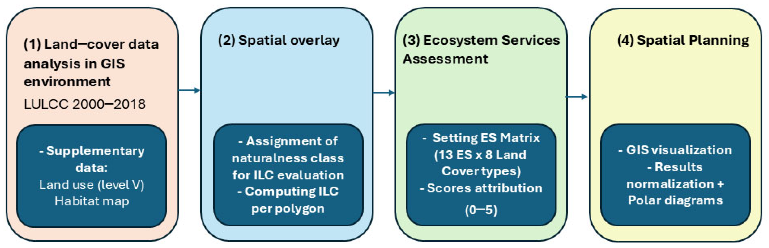
This study uses an integrative spatial assessment method to analyze changes in land use over 19 years, as well as the dynamics of related potential ecosystem services (ESs) on the island of Asinara. The approach is based on models developed and tested by various authors in scientific literature [15,16,40,41], investigating how the provision of ecosystem services depends on the ecological integrity linked to the various types of land cover. To meet the needs of analysis in a small island context regulated by specific policies, the methodology seeks to combine the harmonization of spatial data, reasoning on the conservation status of landscape integrity, related ecosystems and assessing the capacity of ecosystem services through indirect evaluation. The process consists of the following steps (Figure 2):
- characterizing land cover and use transitions from 2000 to 2018;
- assessing landscape integrity status using the Index of Landscape Conservation (ILC);
- estimating ecosystem service potential across land cover types over the timespan studied.
According to recent conceptual revisions [42,43], supporting services are not evaluated independently because they are integrated into regulating and maintenance functions.
Figure 2.
Methodological framework used.
3.1. Land Use and Land Cover Data
Ecosystems perform various functions depending on their structure and health, which in turn affects their capacity to provide specific ecosystem services. These services can differ significantly across scales [44]. We based our research on CORINE Land Cover (CLC) datasets for the years 2000 and 2018 using the European Copernicus Land Monitoring Service (https://land.copernicus.eu/ (accessed on 15 January 2026)) as a source. Although higher-resolution land use datasets are available for intermediate years (e.g., 2003 and 2008), 2000 and 2018 were selected because they represent two distinct ecological and institutional phases in Asinara’s recent history. The year 2000 marks the start of the post-abandonment period, shortly after military and penal activities ceased. In contrast, 2018 marks nearly twenty years of tested outcomes produced by the management of Asinara National Park. This 19-year interval enables the detection of substantial environmental and land use changes while minimizing the impact of short-term fluctuations. Additionally, the 2018 CLC map was overlaid with a regional habitat distribution layer, improving the knowledge between land use units and ecological features.
Intrinsic limitations: although CORINE Land Cover remains a widely used tool for studying LULCC in Europe [45], excellent for monitoring on a regional scale, its resolution (100 m per pixel) is limiting in monitoring and classifying vegetation dynamics at the micro-habitat scale [46], such as ecological processes related to vegetation series progression, patch dynamics, localized erosion phenomena, etc. which are fundamental to define quality of land uses changes in environments such as little islands.
3.2. Naturalness and the Index of Landscape Conservation (ILC)
Providing a spatially explicit screening of landscape integrity is a crucial first step for exploring the potential of key ecosystem functions and their associated ecosystem services. In this study, the degree of landscape naturalness, understood as an attribute derived from the spatial configuration of land-cover patches, is assessed across the whole area of interest, including related marine protected surfaces, toward the evaluation of the Index of Landscape Conservation (ILC), using GIS tools. Contributions from the scientific literature provide additional qualitative validation. The ILC [47] summarizes the distribution of naturalness classes within the area, expressed as follows.
Amax = 100 × (nc − 1)
The ILC ranges from 0 to 1, indicating the proportion of well-preserved environments based on the area above the cumulative percentage curve. Higher scores indicate more natural landscapes, while lower scores reflect areas that have been modified by humans. The index assesses naturalness categories, with accurate ecosystem status depending on selecting the proper category correlated with different classes. This approach reclassified the land use and cover map [48] into naturalness categories (Table 3), allowing for more interpretation of the territorial mosaic characteristics.
Table 3.
Classes of naturalness in 2000 and 2018.
3.3. Land Cover Transition Analysis
Transition matrices were used to identify major land cover changes over time, a common method for detecting significant changes between land cover types [49,50,51,52]. Ecosystem service (ES) capacity was then assessed on a quantitative scale from 0 (negligible) to 5 (very high), based on values from Burkhard et al. [15] for each land cover class. These values were integrated into a GIS environment using (ArcGIS Pro software ESRI©, ver. 10.8) to create ES provision maps, which were then normalized for comparability across different services.
3.4. Ecosystem Services Assessment Through Matrix Scoring
To enhance landscape planning and monitoring and the sustainable management of environmental resources, it is essential to develop a deeper understanding of the spatial and temporal distribution of ecosystem services across various scales, from land parcels to global regions [53,54]. Starting from the premise that ecosystems provide a certain potential of services to humankind based on their functioning, society’s demand for these services transforms this potential into flows. It is important to distinguish between ecosystem service supply and ecosystem service flow [55]. Ecosystem functioning is strongly linked to land cover and land uses, which could serve as proxies for estimating the potential supply of ecosystem services [40,56,57,58,59,60].
We evaluated the ecosystem service potential by analyzing CORINE land cover classes, using the approach developed by Burkhard et al. [15,16], concerning the three categories of provisioning, regulating, and cultural services [41]. A two-dimensional matrix was constructed with 16 ecosystem services as columns and dominant land cover classes as rows. Each land cover type was scored from 0 (no capacity) to 5 (very high capacity) for ES categories. The 0–5 ordinal scoring system was chosen as a standardized top-tier method for quick spatial assessment over large areas, using existing land cover data. It offered comparable results across ES categories, reflecting the relative potential based on land cover traits and ecological literature consensus.
3.5. Visualization, Normalization, and Validation
Obtained scores were linked to spatial units in GIS environment to produce spatial maps of ecosystem service potential across the island.
To facilitate meaningful comparisons between services and land units, scores were adjusted to a common scale. The outputs included:
- -
- Radar (polar) charts
- -
- Thematic ES maps
These tools highlighted trade-offs among ecosystem services and spatial differences in ES capacity. It is also important to note that a score of 0 does not mean the service is absent but indicates a negligible capacity for service provision in this context.
4. Results
4.1. LULCC Evolution
Between 2000 and 2018, Asinara island experienced significant ecological changes due to the cessation of the long-term agricultural penal colony (since 1885) and its designation as a National Park in 1998. The CORINE Land Cover (CLC) maps for those years (Figure 3, Table 4) show that sclerophyllous vegetation (class 3.2.3), broadly characterized by Mediterranean maquis of Euphorbia dendroides, Pistacia lentiscus shrubs of Olea spp. and Cistus, remained the dominant landscape, covering about 3260 ha.
Figure 3.
Land cover in 2000 (a) and 2018 (b) of the Asinara island using the data provided by the National Park of Asinara. Legend (CLC codes): 1.4.2 = Recreational/sports areas (green); 2.1.1 = non-irrigated arable land (yellow); 2.3.1 = Natural pastures (light green); 2.4.3 = Agro-forestry areas (orange); 3.1.1 = Broad-leaved forest (dark green); 3.2.3 = Sclerophyllous vegetation (brown); 3.3.2 = Bare rocks (grey); 3.3.3 = Sparsely vegetated areas (beige).
Table 4.
Transition matrix between land cover types’ surfaces in 2000 and 2018 (areas in ha). Rows show 2000’s surface of LULC; columns, 2018’s surface, both in hectares. From the reading, the values represent surfaces of transitions.
In 2000, agricultural land, mainly non-irrigated arable areas classified as 2.1.1, spanned roughly 241.6 ha, mostly located in the island’s southern and northern hilly regions. By 2018, a distinct land use transformation had been recorded:
- -
- complete conversion of non-irrigated arable land (2.1.1) into pastures (2.3.1), indicating widespread abandonment of agriculture;
- -
- transition of natural grasslands (3.2.1) into both agricultural-natural mosaics (2.4.3) and sclerophyllous vegetation (3.2.3), reflecting secondary succession;
- -
- conversion of sclerophyllous vegetation (3.2.3) into 3.1.1: broad-leaved forest (3.1.1);
- -
- low evolutions of bare rocks (3.3.2) into sparsely vegetated areas (3.3.3) or shrublands (3.2.3).
In the southern part of the island, these changes are especially evident.
Sport and Leisure Facilities (1.4.2) remained a constant and persistent feature both in 2000 and 2018. These areas, mainly related to the conversion of historical buildings related to urban or penal uses to scientific, cultural and sport ones, are located where the headquarters of settlement were located (Fornelli, La Reale, Cala d’Oliva). The lack of urban expansion is due to the National Park’s establishment, engaged in the restoring of already present buildings and the lack of inhabitants, except for those daily workers, which is constant for the whole year, and tourists mainly in from spring to autumn, depending on the ferry connections from Porto Torres to Cala Reale (center of the island) or from Stintino to Fornelli (Southern Asinara). In particular, since 1997, the National Park has renovated several buildings on the island linked to the prison period or to the Maritime Health Station (active from 1995 to around 1915, when it was dedicated entirely to the care of Austro-Hungarian prisoners) to manage activities related to scientific research and monitoring, hospitality (e.g. a hostel) and tourism (e.g. temporary and permanent exhibitions dedicated to the history and environment of the island), in accordance with current legislation and in coordination with the institutional aims of the third-party entities involved in the property. In fact, the island is home to public property assets involving various public authorities (e.g., the Italian Ministry of Inner Affairs; Italian Ministry of the Defence; Autonomous Region of Sardinia; Italian Public Property Agency). The overlay matrix of land cover and habitats (Table 5) further highlights this ecological shift. Most habitats of community interest under the EU Habitat Directive were in 2018 mainly linked to maquis and garrigue vegetation (class 3.2.3). Key habitats include:
- -
- 5330, 6220* (Thermo-Mediterranean and pre-desert schrub, annuals of the Thero-Brachypodietes) with a total area of approximately 2300 ha.
- -
- 9320, 5330 (Olea europea and Ceratonia siliquastrum forests, and Thermo-Mediterranean and pre-desert schrub) with a total area of approximately 1300 ha.
- -
- 5210, 5330 (Arborescent matorral with Juniperus spp. and Thermo-Mediterranean and pre-desert schrub), about 230 ha.
Table 5.
Overlay matrix between CLC classes (2018) and Natura 2000 Habitat’s codes as recognized by Asinara’s Park (ha).
4.2. Index of Landscape Conservation
To evaluate the overall conservation status of the island’s ecosystems, the Index of Landscape Conservation (ILC), which is a synthetic metric based on the proportion of naturalness classes across land cover types [47], was applied. The ILC scores for 2000 and 2018 were 0.74 and 0.76, respectively, suggesting a consistently high degree of naturalness across the landscape over the 19 years.
However, the distribution of the naturalness classes (Table 6) shows significant territorial inhomogeneity in 2018 compared to 2000. In 2000 (Figure 4a), the island’s results were mainly characterized by a high level of landscape conservation in the northern part. By contrast, in the southern part, land conservation was either high, locally high or low, associated with shrubland and rock outcrops. As shown in 2018’s ILC map (Figure 4b), the northern part remained mostly unchanged compared to 2000, except for the most homogeneous patch area characterized by LULCC “upgrade” of forest, while in the southern part, we recorded a decline from very high to high levels of conserved landscape status, although some areas improved from low to medium-high levels. In summary, the ILC scores for 2000 (0.74) and 2018 (0.76) would both suggest high naturalness levels across the island in the studied period, considering a maximum value of 1. Although these scores indicate overall stability, the analysis reveals increased spatial heterogeneity in time, especially in the southern areas. These patterns underscore the potential of ILC in spatial analysis for landscape monitoring.
Table 6.
Naturalness classes related to the different land use cover.
Figure 4.
Landscape Conservation Level is shown in panels a and c, while the Index of Landscape Conservation (ILC) is presented in panels (a,c) for 2000; (b,d) for 2018. Values from 0 (low conservation) to 6 (high landscape conservation) relate to the Index of Landscape Conservation.
4.3. LULCC
The most significant recorded changes consist of the great reduction in agricultural land versus different uses and secondary successional ecosystems. Data show a complete transition from non-irrigated arable land (2.1.1) into natural pastures (2.3.1) and natural grasslands (3.2.1) into sclerophyllous vegetation (3.2.3) and agricultural–natural mosaics (2.4.3). Shrublands partially evolved into broad-leaved forests (class 3.1.1), and bare rock areas (class 3.3.2) transitioned into some sparsely vegetated zones (class 3.3.3). These trends mirror patterns that have already been observed across Mediterranean landscapes, where land abandonment commonly triggers the recolonization of native flora [12,61,62,63,64]. The rise in sclerophyllous plants and broad-leaved forests would suggest the development of more mature and resilient ecosystems [65,66], considering that Mediterranean ones are prone to degradation and desertification [67,68].
4.4. Provisioning ES
The assessment of provisioning ES for 2000 and 2018 suggests changes in the spatial distribution and potential supply across land cover types on Asinara’s ecosystems (Figure 5 and Figure 6).
Figure 5.
Potential provisioning ecosystem services in 2000 (a) and in 2018 (b).
Figure 6.
Potential provisioning ecosystem services (a) in 2000 and (b) in 2018. ES Capacity (Burkhard’s matrix 0–5 scale): 0 = No capacity, 1 = Very low, 2 = Low, 3 = Moderate, 4 = High, 5 = Very high capacity.
In 2000, non-irrigated arable land (2.1.1) showed the highest potential, with an overall score of 26 (see Supplementary Materials—Table S1), reflecting the historical importance of the previous agricultural production on the island.
Natural grasslands (3.2.1) and sclerophyllous vegetation (3.2.3) displayed moderate provisioning potential, with scores of 14 and 13, respectively. These classes are especially associated with wild food and resources for livestock and fauna with biochemical and medicine resources.
The marine environment (5.2.3) achieved the highest overall score (28), indicating the strong potential for fisheries, aquaculture, wild food and resources, marine biomass production, and energy such as mechanical energy from wave movement (energetic abiotic resources). Conversely, sparsely vegetated areas (3.3.2) and bare rocks (3.3.2) exhibited negligible provisioning potential. By 2018, considering the transitions recorded in land uses, potential ES supply has undergone some changes. Forest-related features (3.1.1.), which were not present in 2000, reached the highest peak of 21, mostly due to the timber and wood for fuel as potential “services”, for the presence of wild food and resources, linked to the supposed presence of fruits, mushrooms, (edible) plants—depending on the season—as well as wild animal habitats for hunting opportunities.
Natural pastures (2.3.1), as the evolution of non-irrigated arable land (2.1.1), showed moderate potential as well as agricultural–natural mosaics (2.4.3), rising from natural grassland surfaces (3.2.1) (scores of 18 and 20, respectively). Their contributions mainly involve the production of forage, supporting livestock, abiotic energetic resources, and wild food. There were no changes in CLC classes or in surfaces of LULCC for marine systems, confirming their score for 2000.
4.5. Regulating ES
The assessment of regulating ES supply reveals significant spatial and functional changes in ecosystem capacity processes across Asinara’s land (Figure 7 and Figure 8) in both 2000 and 2018.
Figure 7.
Potential regulating ecosystem services (a) in 2000 and (b) in 2018.
Figure 8.
Potential regulation ecosystem services (a) in 2000 and (b) in 2018. ES Capacity (Burkhard’s matrix 0–5 scale): 0 = No capacity, 1 = Very low, 2 = Low, 3 = Moderate, 4 = High, 5 = Very high capacity.
The analysis of the year 2000 shows that natural grasslands (3.2.1) reached the highest potential score (25) due to the great role they play in climate regulation at the global and local levels due to the long-term storage of potential greenhouse gases they store in soils, for instance, by roots in soil, contributing also to mitigating soil erosion, nutrient regulation, water purification, and other ESs with low scores (pollination, natural hazard regulation, etc.). Sclerophyllous vegetation (3.2.3) had a moderate score, reaching a cumulative value of 18. It provides various services, such as the ecosystem’s ability to filter and decompose organic material in water and soils, pollination, and microclimate regulation. In contrast, non-irrigated arable lands (2.1.1) showed a low ES potential score, even contributing to climate and water regulation and the ability to control pests and diseases due to genetic variations in plants and animals, reinforcing resilience to diseases and actions of predators, parasites, and others. Minimal regulating functions were associated with sparsely vegetated areas (3.3.3) and bare rock (3.3.2), due to their supposed limited vegetation suitability and biological activity. The marine system (5.2.3) scored a total of 20, with the highest contribution to regulation of waste, supporting functions like climate regulation (global and local level), waste absorption, and pest control, among others. Many of these functions are supported by primary production in water, as well as the presence of Posidonia oceanica meadows, better defined by the presence of the Natura 2000’s Habitat 1120*, essential to the marine ecosystem’s regulatory capacity in producing oxygen, absorbing CO2, and mitigating coastal erosion by marine movements. By 2018, regulating ES supply setting changed due to the presence of broad-leaved forests (3.1.1), apparently referring to land cover evolution by sclerophyllous vegetation areas (as it was classified in CLC 2000). The land cover type contributed to the definition of the score linked to the potential for ecosystem services (ES), which reached its highest value in the case of forest. This is due to the role of forest ecosystems in promoting climate regulation on various scales, contributing to the reduction of erosion and soil formation, and regulating nutrients.; their area (ca. 20 ha) could limit their overall impact across the island. Agricultural–natural mosaics (2.4.3) showed good performance in regulating ES supply throughout the ES selected (score: 23).
Considering the ES score related to classes and not surface-weighted, sclerophyllous vegetation’s (3.2.3) score confirms that of 2000’s value as the total score (18), despite changes in surfaces (e.g., the evolution of 20 ha of forest). Non-irrigated agricultural areas (2.1.1) are classified as natural pastures (2.3.1) in 2018, gaining a score of 13, related to contributions in waste regulation, global and local climate regulation, regulation of water fluxes, as well as nutrients, erosion and natural hazard regulation. Both land uses contributed moderately to regulating ES, considering water, nutrient and waste regulation. Pollination services are recognized only for sclerophyllous vegetation among the two.
Recreational areas (1.4.2) are not recognizable because they consist essentially of artificial surfaces. Sparsely vegetated zones (3.3.3) have the same value as 2000. Figure 8 illustrates the differences between the two years in terms of regulation potential for the SE at the island level. Essentially, the transition scenario in the production of regulatory ES has changed not in terms of the areas occupied by different land uses but related to the evolution of land uses over time, changing code classes.
4.6. Cultural ES
The assessment of cultural ESs (CESs) considers recreational uses, esthetics, tourism and spiritual values (Figure 9 and Figure 10). The year 2000’s CES potential assessment matrix shows marine areas (class 5.2.3), with the highest value scoring 22, related to recognized value for recreational uses, tourism, landscape esthetics, and more broadly knowledge production. Natural grasslands (3.2.1) scored 19, highlighting their CES significance for knowledge, esthetics and inspiration, cultural and natural diversity, and heritage. Low scores were recorded for sclerophyllous vegetation (3.2.3) and bare rocks (3.3.2) land use classes. Sparse vegetation (3.3.3) and non-irrigated arable land reached a low score, mainly considering knowledge, natural heritage and natural diversity (3.3.3), knowledge, landscape esthetics and inspiration. Recreational facilities classes (1.4.2) arise for recreation and tourism potential, landscape esthetic and inspiration, cultural heritage and cultural diversity, while non-irrigated arable land (2.1.1) arises for cultural heritage and cultural diversity, knowledge and lastly recreation and tourism as CES. Notably, by “knowledge”, we refer, like Burckhard et al. [16], to traditional knowledge and specialist expertise arising from living in this particular environment.
Figure 9.
Potential cultural ecosystem services (a) in 2000 and (b) in 2018.
Figure 10.
Potential CES (a) in 2000 and (b) in 2018. ES Capacity (Burkhard matrix 0–5 scale): 0 = No capacity, 1 = Very low, 2 = Low, 3 = Moderate, 4 = High, 5 = Very high capacity.
In 2018, the highest potential was observed for broad-leaved forests (3.1.1), scoring 27, contributing potentially to recreation and education opportunities. Sclerophyllous vegetation (3.2.3) and agricultural-natural mosaics (2.4.3) showed notable potential (scores of 16 and 14), which could relate to Mediterranean rural landscape imaginaries as cultural values.
4.7. Grazing Pressure Sensitivity Analysis
Although the ILC results indicate a general ecological recovery trend for the studied period at Asinara, we cannot consider the notable ecological effects of free-ranging animals, especially goats and wild boars, impacting the natural evolution of landscape. Uncontrolled grazing exerts uneven pressure across the landscape, hindering the progression from shrubland to forest and limiting the natural evolution of vegetation, especially in southern areas [25]. CORINE data do not record direct animal presence through land use classes. To minimize this and achieve a more realistic result of LULC for associated ESs from ILC evaluation, we performed a post hoc sensitivity analysis to assess how grazing affects ecosystem services, utilizing proxy zones and degradation factors (Table 7).
Table 7.
Summarizing island-wide impacts of grazing in ecological recovery.
High-grazing zones included southern agricultural mosaics (CLC 2.4.3, 1015.7 ha), pastures (CLC 2.3.1, 2385.6 ha), and areas with stalled grassland–shrub transitions, making up about 35% of the island. Considering herbivore pressure (look up Table 1) that hinders succession, we also evaluated the grazing-adjusted weight, which highlights a substantial reduction to be considered to provide ES (−20% regulating ES, −15% cultural ES).
5. Discussion
Recent studies [42,43] highlight the challenge of understanding how biodiversity changes affect ecosystem services, particularly within protected areas where human activities are restricted but ecological processes remain dynamic. From the establishment of a National Park, the island underwent significant ecological shifts, as reflected in land cover changes between 2000 and 2018. Here are some considerations concerning methodological limitations, what the model did not say, and future perspectives for research to monitor mid-term ES dynamics in Asinara.
5.1. Methodological Limitations and Uncertainty Quantification
This study identifies three main sources of uncertainty: CLC classification errors (approximately 85% accuracy), subjectivity in ES matrix scores (within ±1 ordinal level), and temporal interpolation between 2000 and 2018. Nevertheless, a formal uncertainty analysis was not performed due to specific methodological and practical considerations:
- -
- exploratory study design: our research establishes baseline ES patterns using standardized tier-1 methods (Burkhard matrix + CLC). Extensive validation datasets for Asinara are unavailable, including high-resolution time-series or field ES measurements, which are necessary for comprehensive uncertainty analysis;
- -
- data limitations: without independent validation data for Asinara-specific CLC classes or ES delivery from 2000 to 2018, it is not possible to generate meaningful error matrices or calibrate scores accurately;
- -
- spatial scale focus: the analysis concentrates on relative spatial patterns, over 95% consistency across ±15% error scenarios according to the literature, rather than on absolute ES quantities used in policy decision thresholds.
Future research will include quantitative uncertainty analysis once high-resolution and field monitoring-based data are accessible.
The ecosystem service assessment presented here is subject to several methodological constraints. First, the use of an ordinal, expert-based scoring matrix, while suitable for preliminary and spatially explicit analyses, lacks the biophysical grounding of fully quantitative models such as InVEST or ARIES, limiting their applicability for detailed trade-off and uncertainty assessments. Validation was therefore limited to comparing land cover- change dynamics (using Copernicus Land Use) and vegetation evolution using Sentinel-2 images and Google Earth images’ archive, revealing significant gaps such as the lack of forest cover in the Copernicus Land Use map for the year 2000, despite the presence of forests attested by other available dataset (e.g., Copernicus LULC for 1990 and 2006), an error incorporated in the dataset used. Therefore, reliance on harmonized large-scale datasets (e.g., CORINE Land Cover, habitat overlays) introduces limitations related to thematic generalization and coarse spatial resolution, potentially obscuring fine-scale heterogeneity, microhabitat fragmentation, and management-relevant processes, particularly in a studied context similar to other Mediterranean complex case studies reported in the literature [51,61,62]. Yet such models primarily capture landscape objects rather than processes and conservation indices may mask apparently positive trends, as already discussed, due to uncertainties embedded in baseline datasets; thus, field-based monitoring remains indispensable for validation.
5.2. What the Model Does Not Say: Historical Provisioning, Grazing Legacies, and Constrained Futures
The spatially explicit assessment of ecosystem services (ESs) aimed at identifying priority areas for sustainable management; nevertheless, it accounted for several dimensions of CLC-based ESs, and types of information have not been captured by the model.
We should in fact recognize that, with respect to provisioning services, livestock historically represented a core resource for island inhabitants. Animals were introduced to Asinara long before 1885, when the agricultural penal colony initiated a new agro-ecological trajectory. Dairy and meat production from sheep, goats, and cattle supported local livelihood, complemented by the extraction of fibers such as wool, leather and horns, which were last widely used for artefacts. Timber was exploited for agricultural tools and construction materials [69]. Wild plants such as Phragmites australis, Juncus spp., resprouts of Olea spp., and stems of Asphodelus ramosus were traditionally used as fiber to weave fishing gear, traps, and food baskets, as documented in the ethnographic collections of the Museo della Tonnara in Stintino. Lobster and tuna fisheries were widespread along the western coasts of northern Sardinia until the twentieth century, supporting Mediterranean trade networks, together with even older coral fisheries. Due to their insular condition, historical provisioning for Asinara’s inhabitants (Asinaresi) was therefore closely linked to marine exploitation.
In Asinara, a thriving tuna fishery operated until the local community was displaced in 1885; some of its ruins remain visible in La Reale Bay. Following the relocation of the sinaresi, a new settlement was established on the mainland, where present-day Stintino stands (the nearest peninsula of Sardinia mainland to the Asinara island), near the Le Saline tuna fishery, which provided employment and subsistence for the transferred families. These fishing traditions persist in Stintino’s cultural identity [70], where we could record the presence of Italy’s oldest fishing cooperative.
Considering other provisioning services, while freshwater retention is underrepresented by Copernicus-based assessments, related ESs are therefore likely underestimated. Asinara’s long settlement history underscores the strategic importance of freshwater resources for human survival. The island hosts approximately fifty natural springs and many structures to intercept, extract and collect waters, such as wells, livestock watering troughs, and several artificial dams, built to support agricultural activities and sanitary needs, especially during the penal colony period [source: Asinara National Park]. These resources are currently affected by high nitrate inputs linked to animal loads, rendering water unsuitable for several uses, including drinking. As a result, the island is not self-sufficient in potable water, and tankers periodically supply facilities used for institutional and research purposes. Concerning provisioning materials used by local availability, in earlier periods, pre-prison communities relied on local stone to build houses and service structures. From Roman times onward, the granite of the island was quarried to produce columns and construction blocks (source Asinara National Park); machinery used in the twentieth century’s extraction remains visible along the present-day thematic railway of the granite trail in the south-eastern part of the island.
Following the establishment of the agricultural penal colony, farming activities were organized for subsistence for both convicts and prison-guard families. Some old land uses are no longer detectable through land-cover analysis, such as vineyards. Only some hedgerows survive—such as those in the Fornelli plain, marking former parcel boundaries. With the abandonment of permanent settlement, most provisioning services ceased. The new island’s life after the establishment of Asinara National Park marked a new phase for land resources and land governance: human presence and activities were restricted, except for conservation or scientific research purposes, to recognize the value of wilderness to be saved under protection status [71,72].
Article 12 of the Park Plan Implementation Rules (2008) specifies prohibitions concerning wildlife disturbance, vegetation removal, extraction of geological or archeological materials, quarrying, and earthworks, except for authorized management or research activities.
Unlike other former agricultural penal colonies, such as Pianosa Island [62], livestock was not eradicated at the time of park establishment, despite the formal suspension of agro–silvo–pastoral practices. Seeking to reconcile conservation with the maintenance of historical landscapes, Brandano et al. [73] estimated sustainable livestock loads in 1998 of 105 cattle, 100 horses, 52 donkeys, 160 goats, 340 mouflons, and 70 wild boars. Animal numbers in 2000 and 2018—and up to the present—have exceeded these thresholds (Table 2), despite annual removal efforts [38] carried out by different public authorities, e.g., Regional Forest Agency, Asinara National Park, and others.
Unmanaged grazing—particularly by goats—generates strong localized pressures, hindering habitat regeneration, forest succession, and regulating services such as biodiversity support, soil nutrient cycling, plant productivity, and freshwater regulation. Historical disturbances, including repeated fires, intensive grazing, and the confinement of approximately 24,000 Austro-Hungarian prisoners during the First World War, severely degraded Juniperus woodlands and pre-forest maquis, particularly in lowland coastal areas [72,74,75].
Natural forest expansion remains constrained by wild boar overgrazing, which significantly limits holm oak regeneration and soil stability. The 2010 Park Management Plan (2014) set a target of increasing forest cover to at least 30% of the island [32], yet spatial prioritization, operational targets, and temporal frameworks remain weak, owing to complex multi-level governance and administrative inertia. Afforestation campaigns carried out in the 1990s by the Regional Forest Agency of Sardinia—planting approximately 70,000–80,000 saplings, 80% of which were oaks—experienced low survival rates because of insufficient irrigation [72], although site-suitability studies exist that could guide future interventions [74,75].
Current management includes the gradual eradication of goats and wild boars, whose trampling and rooting directly damage seedlings and facilitate insect outbreaks (e.g., Kalotermes flavicollis, Thaumetopoea processionea) [72,75], further reducing forest resilience. The current Park Management Plan (2024) aims to adopt an ecosystem-based approach to restoring potential vegetation series and holm oak woodlands.
Considering agro-pastoral legacies, herbaceous communities—classified as natural pastures and temporarily wet grasslands (2.3.1) dominated by graminoids, annual forbs, and legumes—retain the highest land cover type incidence of formerly cultivated species [25]. These features should be explicitly incorporated into restoration strategies aligned with the ecosystem-based framework adopted in the Park Management Plan (2024).
With respect to renewed provisioning services, since 2012, a collaboration between the Asinara National Park and the University of Sassari has developed a research initiative that evolved into a productive enterprise in 2015, focused on cosmetics derived from native plants. The development of sustainable harvesting protocols could strengthen the park’s sustainability reporting and provide transferable models for other protected areas. Regulatory frameworks for sustainable productions in protected areas generated the Park Quality Mark label [76]. While Asinara currently certifies mainly tourism services, future regulations could support value-added processing activities, such as cosmetics based on local plants, but also small-scale olive oil productions, due to possible olive farming in the Trabuccato, where a small and old olive grove was restored in 2015. It is important to add that scientific insights from Olea spp. wild olive trees are rarely present on Asinara [77].
Concerning regulating services, despite being assigned minor roles to coastal rocky habitats by the ES supply matrix, bare rocks (3.3.2) and sparsely vegetated areas (3.3.3) contribute to biodiversity conservation due to the seed banks they host, with the highest numbers of endemic species compared with other land cover types—including Bellium bellidioides, Limonium acutifolium, Romulea requienii, and Centaurea horrida—the latter listed as threatened on the European Red List [30,33].
Cistus scrub in sclerophyllous vegetation (3.2.3) exhibits the lowest proportions of cultivated species. According to Driessen et al. [32], plant species richness was highest in sclerophyllous shrublands, with Cistus monspeliensis and Euphorbia dendroides displaying high diversity with minimal synanthropic influence, while the greatest species diversity occurred in open coastal garrigue and grasslands. Harsh environmental conditions—shallow soils, wind exposure, high solar radiation, and seawater spray—generate strong spatial heterogeneity and mosaics of microhabitats.
Herbivores play complementary roles in vegetation dynamics: goats disperse shrubs and forbs, whereas donkeys favor grasses and herbaceous species [77]. Overgrazing, therefore, also indirectly threatens and/or influences other taxa, including animals (e.g. Ichthyaetus audouinii [38], coprophagous beetles [34], others).
With regard to carbon storage, as a regulating ES, secondary succession and land-cover changes have not been explicitly contextualized. The year 2018’s evidence of a forest parcel (3.1.1) allows us to evaluate the importance of these features to carbon storage, for instance. Schirru et al. [78] estimated in 2018 a potential carbon inventory for Asinara island, reporting for forests patches approximately an amount of 15 t C ha−1 yr−1 storage, related to the above-ground biomass pool. Concerning Mediterranean maquis (shrublands), carbon storage is almost 24 t C ha−1 yr−1, highlighting the importance of secondary succession in contributing more than mature forests to carbon cycle and storage, supporting the mitigation of climate change at the local and global level, as well for nutrient cycling, wild food and other provisioning resources, and, as already mentioned, as biodiversity shelter concerning regulation ES.
Concerning marine ecosystems, the presence of the Posidonia oceanica habitat (1120*) delivers provisioning and regulating services, including fisheries support, carbon sequestration, coastal protection, and climate mitigation [79,80,81]. While the 2015 NPA monitoring activities reported disturbed Posidonia oceanica meadows (source: Asinara Marina Protected Area), MPA policies have progressively improved conservation outcomes, providing rules and restrictions for fishing and boat mooring, designing no-take zones and buoy fields. Since the decree establishing the MPA in 2002, fishing on the island of Asinara has been prohibited for the local fleet, except for a few boats from Porto Torres and Stintino, which practise traditional small-scale fishing and are authorised by the Asinara National Park to fish at a distance of more than 150 m from the island’s coast. Only the areas of sea with the highest level of protection in the MPA (Zone A) are completely excluded from fishing and navigation activities. By ministerial decree, trawling is prohibited ‘within three nautical miles along the western coast of the island and within a depth of fifty metres along the eastern and southern coasts’ within the MPA, in order to promote fish repopulation and the renewal of Posidonia oceanica. Studies conducted within the Tavolara–Punta Coda Cavallo Marine Protected Area (north-eastern Sardinia) have enabled scientists and authorities to assess both the economic benefits and the environmental impacts generated by authorized tourism-driven activities, such as fishing, recreational boating, and diving. These assessments have included, for example, estimates of greenhouse-gas emissions associated with each activity and have supported reflections on possible forms of environmental compensation proportional to their impacts [82]. Such analyses aim, on the one hand, to determine the carrying capacity of the marine ecosystem and, on the other, to evaluate the most effective mitigation scenarios to reduce tourism pressure and enhance its long-term sustainability within the MPA. Natural parks and MPAs’ visitors generally show a strong environmental awareness and are often willing to pay a premium to support ecological initiatives. These areas, which are called upon to play an exemplary role in nature conservation, are already taking measures to reduce CO2 emissions, such as using renewable energy and conserving fragile habitats; however, these interventions often require insufficient financial resources. To bridge this gap, it is proposed to leverage consumer surplus through visitor-oriented emissions offset projects. However, for such initiatives to be effective and credible in voluntary carbon markets, they need to be developed on a supra-local scale [83].
Some ideas to orient sustainability with respect to Asinara’s stakeholders’ spectrum (recognizing public authorities and tourist and business subjects) could be achieved by promoting local carbon credit schemes by terrestrial and marine systems in (and surrounding) the island of Asinara.
Scientific insights have shown that seagrass meadows sequester approximately 0.7 t CO2 ha−1 yr−1 and produce 27.8 t O2 ha−1 yr−1 (SEAGRASS project, funded by European LIFE+ Programme), underlying their role as nature-based solutions to cope with climate change and showing their potential to mitigate greenhouse gases produced to reach, live, and experience Asinara as a tourist, for instance.
The assessment of ES in PAs and the adoption of carbon-credit mechanisms based on certified reservoirs could help in evaluating payment-for-ecosystem-services strategies to rethink and orient offsetting tourism-related impacts, particularly related to summer peak seasons. Complementarily, emerging biodiversity-credit schemes—e.g., those linked to habitat restoration, endemic species recovery, or seagrass conservation—could provide additional incentives for proactive management, aligning tourism pressures with measurable conservation outcomes and supporting targeted interventions in grazing control, forest regeneration, and marine habitat recovery.
Cultural ecosystem services have expanded following the establishment of Asinara Park. Recreation, environmental education, and esthetic appreciation reinforce identity, well-being, and heritage values [84,85,86]. These services are largely mediated through regulated tourism along trails and guided itineraries [87] under schemes and protocols of the European Charter for Sustainable Tourism accreditation [88].
The island does not offer a wide range of hotels (except for one hostel and one guesthouse), restaurants or other services to account for the role of tourism in assessing cultural services. Despite this, in recent decades, the National Park authority promoted several educational and training activities thanks to Asinara’s environmental and tourist guides, which engaged students, citizens and tourists in environmental activities, facilitating the culture of environmental sustainability and nature conservation. The number of articles, essays, environmental and cultural projects focusing on the island of Asinara could be used as an indicator to assess the increase in knowledge production, as a cultural ecosystem service linked to the island, since 1997 (e.g., https://www.parcoasinara.org/en/activities/scientific-research/ (accessed on 15 January 2026)).
Persistent tensions nevertheless surround representations of the island as “wilderness” from outsiders’ perspectives, which may obscure its long socio-ecological history [71]. The active involvement of communities of the mainland, as well as extended partnership, participatory mapping, and social valuation approaches, is therefore recommended to integrate local memory and territorial identity into cultural-service planning [89,90]. Lai et al. [89] carried out a study to represent Asinara’s CES as perceived by coastal communities of Stintino, Porto Torres and Sassari (facing geographically and situated historically with the Asinara’s events), using participatory approaches through techniques of Public Participatory GIS. Moving from the knowledge of people concerning names of places, the analysis explores enlarged community values and relationships in a spatially explicit way. By reflecting on their experience and feelings about Asinara, respondents let their inner values emerge, together with a personal way of “living” the island, be it through the lens of their communities’ memories, families, wishes, or by applying, even subconsciously, the nature conservation imaginaries of the Asinara National Park. Biodiversity hotspots, functional areas, or no-entry no-take areas were considered. Insights allowed a multifaceted perspective of CES supplied by the island to be represented, but also the identification of multiple, and overlapping, identities of Asinara, which could further be expanded in future research by investigating and also integrating tourists’ perceptions.
Recent studies concerning Italian society’s perspectives regarding MPAs [91] reveal that in 2014–2021, an improvement in perceptions and environmental awareness regarding Marine Protected Areas, but also the persistence of significant critical issues related to poor public knowledge and the need for more inclusive governance models. To strengthen the effectiveness of MPAs in promoting CESs, it is essential to invest in targeted ocean literacy programs, positive and scientifically sound communication strategies, active participation tools such as citizen science, and stable management resources capable of integrating ecological protection and socio-economic benefits. In this regard, Asinara National Park has invested substantially through several regional, national, and international projects that use the island as a case study, demonstrating strong institutional commitment and fostering an up-to-date and cohesive network of authorized and certified MPA-related SMEs, together with other public and private stakeholders actively engaged in the Asinara context. In order to evaluate the growing interest in Asinara island recorded in recent decades for research purposes, by a broad scientific community, a quick overview on Web of Science © shows 61 articles and scientific papers, as shown per thematic sector in Figure 11 (keywork: “Asinara” in “title search”). Scientific interest in Asinara increased since the establishment of the National Park (1997), as shown in Figure 12. Main interests were recorded for the Ecology, Zoology, Biodiversity Conservation and Marine Biology sectors, revealing the active role of scientific research in promoting studies that could support Asinara’s complex ecosystem governance. Several other papers, books and reports (mainly in Italian) are also inventoried on the Asinara National Park website. Overall, ecosystem service patterns on Asinara emerge from the interaction between ecological processes, historical land use legacies, and governance arrangements. LULCC maps describe configurations and transformations of land cover, predominantly morphological, unable to reflect the qualitative and functional status of ecosystems. If integrated with assessments of potential and actual ecosystem services, maps could go beyond, to support adaptive governance processes geared towards sustainability, particularly in PAs, operating as cognitive mediation devices, contributing to the cultural dimension of the society-nature relationship and making explicit the relationships between ecological structure, socio-ecological benefits and land management choices PAs.
Figure 11.
Number and topics of scientific papers with “Asinara” in the title; data derived from Clarivate™ (Web of Science™, January 2026).
Figure 12.
Publications using “Asinara” in the title, time-lapse 1991–2025; data derived from Clarivate™ (Web of Science™, January 2026).
6. Conclusions
Conservation cannot rely solely on the institutional mandate of public bodies; it requires stable leadership, scientific expertise, and administrative continuity. On Asinara island, multiple institutions coexist with fragmented responsibilities and historically constrained, coherent long-term strategies [92]. Ecosystem services represent the benefits societies derive from ecosystems, and in protected areas, the key challenge is to safeguard their future provision even in the absence of direct extractive uses. The conservation value of protected areas lies in their capacity to maintain ecological functions, restore degraded systems, and protect species and habitats of concern, many of which are historically co-produced through long-term environmental processes and human impacts that were not always sustainable. This makes ecosystem service assessment particularly relevant for guiding conservation priorities. Our results show that unmanaged land-cover trajectories—such as passive rewilding following agricultural abandonment—reshape ecosystem services through complex socio-ecological assemblages. From 2000 to 2018, LULCC reconfigured provisioning, regulating, and cultural services while generating new management challenges linked to herbivore pressure, habitat dynamics, and tourist demand. Protection status alone is therefore insufficient to guarantee favorable ecological trajectories [93]. Mid-term landscape evolutions—including abandoned infrastructures, feral animal populations, and hybrid habitats challenge simplified narratives of wilderness. On Asinara, these configurations coexist with imaginaries of pristine nature, revealing tensions between symbolic representations and material ecological processes. Effective management requires prioritizing key pressures, notably invasive species control and herbivore regulation, through eradication or sustainable containment, alongside adaptive grazing regimes and the possible reintroduction of lower-impact livestock species, such as sheep, in place of goats [94]. Spatial zoning based on ecosystem service hotspots—such as broad-leaved forests, sclerophyllous communities, and Posidonia oceanica meadows—can inform sustainable farming—as well as fishing restock—schemes and low-impact tourism [16]. At the same time, tourism growth and maritime traffic introduce pressures, calling for explicit carrying capacity assessment and compensation mechanisms grounded in payments for ecosystem services, including support for sustainable local production and carbon or biodiversity credits. Linked to transparent monitoring systems, such instruments may align visitor behavior and governance commitments, ensuring long-term ecosystem maintenance. Participatory governance further strengthens conservation by embedding cultural ecosystem services within locally valued practices and knowledge systems, enhancing social–ecological resilience [20,95,96,97]. Integrated monitoring frameworks—combining high-resolution remote sensing, biodiversity surveys, hydrological measurements, and socio-economic data for adaptive management and for refining model-based assessments [86,98,99]. Ultimately, protected areas cannot be treated as static units. Sustainability emerges as a distributed responsibility across actors, temporalities, and governance scales. Ecosystem service models provide partial and situated representations, shaped by historical land use legacies, data constraints, and ongoing management decisions. Asinara exemplifies a hybrid, assembled landscape in which cultural history, ecological processes, and institutions intersect. From a “Post-Normal Science” perspective [100], conservation in island contexts is contingent, adaptive, and inherently political. Protected areas thus function as sustainability laboratories, where co-produced knowledge and experimental governance may strengthen resilience while keeping future trajectories open.
Future research should integrate field-based monitoring and expert elicitation to calibrate ecosystem service scores and to parameterize biophysical models for regulating services such as carbon storage, erosion control, pollination, seed dispersal, and climate-sensitive conditions. Higher-resolution spatial datasets would improve detection of fine-scale habitat dynamics.
Comparative analyses across protection zones (A, B, and C) are needed to disentangle governance effects on ecosystem service provision, while participatory mapping and social valuation approaches remain crucial for capturing cultural ecosystem services and supporting ecosystem-based management in Mediterranean island protected areas.
Supplementary Materials
The following supporting information can be downloaded at https://www.mdpi.com/article/10.3390/su18052303/s1. Table S1: ES potential supply indexes based on Burkhard et al. 2012 [16], using land cover maps for the year 2000. Table S2: ES potential supply indexes based on Burkhard et al. 2012 [16], using land cover maps for the year 2018.
Author Contributions
Conceptualization, C.C., R.G., M.S., U.S. and W.N.; methodology, C.C., M.S., R.G. and D.C.; validation, C.C., M.S., D.C., V.G. and U.S.; formal analysis, all the authors contributed; investigation, R.G., A.L. and V.G.; resources, D.C.; data curation, all the authors contributed; writing—original draft preparation, C.C., M.S., R.G., A.L., U.S., W.N. and D.C.; writing—review and editing, C.C., M.S. and W.N.; project administration, D.C. All authors have read and agreed to the published version of the manuscript.
Funding
This research was funded by European Maritime, Fisheries Operative Programme, 2014/2020—“Gestione partecipata degli ecosistemi marini nella AMP Isola dell’Asinara con il coinvolgimento dei pescatori” project, 49/RBC/18—PO FEAMP, Misura 1.40, CUP J52G19000160006.
Data Availability Statement
Data are available upon reasonable request.
Acknowledgments
We would like to acknowledge the support and collaboration provided by National Park of Asinara.
Conflicts of Interest
The authors of this manuscript, Rossella Guadagno and Alexandre Lazarou, are respectively employed by SOGESID spa company and Long Zanasi & partners company. The remaining authors declare that this research was conducted without any commercial or financial relationships, which might be interpreted as a potential conflict of interest.
Abbreviations
The following abbreviations are used in this manuscript:
| ES | Ecosystem Services |
| PA | Protected Area |
| CES | Cultural Ecosystem Services |
| SCI | Site of Conservation Interest |
| SPA | Special Protection Area |
| CLC | CORINE Land Cover |
| LULCC | Land Use Land Cover Changes |
References
- Scheffers, B.R.; De Meester, L.; Bridge, T.C.L.; Hoffmann, A.A.; Pandolfi, J.M.; Corlett, R.T.; Butchart, S.H.M.; Pearce-Kelly, P.; Kovacs, K.M.; Dudgeon, D.; et al. The broad footprint of climate change from genes to biomes to people. Science 2016, 354, aaf7671. [Google Scholar] [CrossRef] [Scilit] [PubMed]
- Maestro, M.; Pérez-Cayeiro, L.M.; Chica-Ruiz, J.A.; Reyes, H. Marine protected areas in the 21st century: Current situation and trends. Ocean Coast. Manag. 2019, 171, 28–36. [Google Scholar] [CrossRef] [Scilit]
- Gaglio, M.; Aschonitis, V.; Castaldelli, G.; Fano, E.A. Land use intensification rather than land cover change affects regulating services in the mountainous Adige river basin (Italy). Ecosyst. Serv. 2020, 45, 101158. [Google Scholar] [CrossRef] [Scilit]
- Neugarten, R.A.; Moull, K.; Martinez, N.A.; Andriamaro, L.; Bernard, C.; Bonham, C.; Cano, C.A.; Ceotto, P.; Cutter, P.; Farrell, T.A.; et al. Trends in protected area representation of biodiversity and ecosystem services in five tropical countries. Ecosyst. Serv. 2020, 42, 101078. [Google Scholar] [CrossRef] [Scilit]
- Millennium Ecosystem Assessment. Ecosystems and Human Well-Being: A Framework for Assessment; Island Press: Washington, DC, USA, 2003. [Google Scholar]
- Maxwell, S.L.; Cazalis, V.; Dudley, N.; Hoffmann, M.; Rodrigues, A.S.L.; Stolton, S.; Visconti, P.; Woodley, S.; Kingston, N.; Lewis, E.; et al. Area-based conservation in the twenty-first century. Nature 2020, 586, 217–227. [Google Scholar] [CrossRef] [Scilit]
- McCarthy, C.; Banfill, J.; Hoshino, B. National parks, protected areas and biodiversity conservation in North Korea: Opportunities for international collaboration. J. Asia-Pac. Biodivers. 2021, 14, 290–298. [Google Scholar] [CrossRef] [Scilit]
- Floris, M.; Gazale, V.; Isola, F.; Leccis, F.; Pinna, S.; Pira, C. The Contribution of Ecosystem Services in Developing Effective and Sustainable Management Practices in Marine Protected Areas. The Case Study of “Isola dell’Asinara”. Sustainability 2020, 12, 1108. [Google Scholar] [CrossRef] [Scilit]
- Nassl, M.; Löffler, J. Ecosystem services in coupled social–ecological systems: Closing the cycle of service provision and societal feedback. Ambio 2015, 44, 737–749. [Google Scholar] [CrossRef] [Scilit]
- Araya-Piñones, A.; Bakit, J.; Flores, M.; Guerrero, M.; Silva, M.; Valencia-Ceballos, L.; Varela, F.; Aramayo, D.; Poblete, R.; Villasante, S. Valuating ecosystem services of coastal wetlands through an interdisciplinary educational experience. Environ. Dev. Sustain. 2024, 21. [Google Scholar] [CrossRef] [Scilit]
- Takacs, V.; O’Brien, C.D. Trends and gaps in biodiversity and ecosystem services research: A text mining approach. Ambio 2023, 52, 81–94. [Google Scholar] [CrossRef] [Scilit]
- Baldi, V.; Bellino, A.; Baldantoni, D. Small-scale land use effects on plant communities in Mediterranean urban ecosystems. Ecol. Indic. 2025, 170, 113051. [Google Scholar] [CrossRef] [Scilit]
- Shi, X.; Ning, Q.; Lei, Z. Impacts of the land use transition on ecosystem services in the Dongting Lake area. Front. Environ. Sci. 2024, 12, 1422989. [Google Scholar] [CrossRef] [Scilit]
- Li, K.; Hou, Y.; Fu, Q.; Randall, M.T.; Andersen, P.S.; Qiu, M.; Skov-Petersen, H. Integrating decision-making preferences into ecosystem service conservation area identification: A case study of water-related ecosystem services in the Dawen River watershed, China. J. Environ. Manag. 2023, 340, 117972. [Google Scholar] [CrossRef] [Scilit] [PubMed]
- Burkhard, B.; Kandziora, M.; Hou, Y.; Müller, F. Ecosystem Service Potentials, Flows and Demands—Concepts for Spatial Localisation, Indication and Quantification. Landsc. Online 2014, 34, 1–32. [Google Scholar] [CrossRef] [Scilit]
- Burkhard, B.; de Groot, R.; Costanza, R.; Seppelt, R.; Jørgensene, S.E.; Potschin, M. Solutions for sustaining natural capital and ecosystem services. Ecol. Indic. 2012, 21, 1–6. [Google Scholar] [CrossRef] [Scilit]
- García-Nieto, A.P.; García-Llorente, M.; Iniesta-Arandia, I.; Martín-López, B. Mapping forest ecosystem services: From providing units to beneficiaries. Ecosyst. Serv. 2013, 4, 126–138. [Google Scholar] [CrossRef] [Scilit]
- Martínez-Fernández, J.; Ruiz-Benitoa, P.; Zavalaa, M.A. Recent land cover changes in Spain across biogeographical regions and protection levels: Implications for conservation policies. Land Use Policy 2015, 44, 62–75. [Google Scholar] [CrossRef] [Scilit]
- Liu, S.; Huang, G.; Wei, Y.; Qu, Z. Monitoring and Assessing Land Use/Cover Change and Ecosystem Service Value Using Multi-Resolution Remote Sensing Data at Urban Ecological Zone. Sustainability 2022, 14, 11187. [Google Scholar] [CrossRef] [Scilit]
- Marino, D.; Barone, A.; Marucci, A.; Pili, S.; Palmieri, M. Impact of Land Use Changes on Ecosystem Services Supply: A Meta Analysis of the Italian Context. Land 2023, 12, 2173. [Google Scholar] [CrossRef] [Scilit]
- Lorilla, R.S.; Poirazidis, K.; Kalogirou, S.; Detsis, V.; Martinis, A. Assessment of the Spatial Dynamics and Interactions among Multiple Ecosystem Services to Promote Effective Policy Making across Mediterranean Island Landscapes. Sustainability 2018, 10, 3285. [Google Scholar] [CrossRef] [Scilit]
- Maes, J.; Liquete, C.; Teller, A.; Erhard, M.; Paracchini, M.L.; Barredo, J.I.; Grizzetti, B.; Cardoso, A.; Somma, F.; Petersen, J.-E.; et al. An indicator framework for assessing ecosystem services in support of the EU Biodiversity Strategy to 2020. Ecosyst. Serv. 2016, 17, 14–23. [Google Scholar] [CrossRef] [Scilit]
- Nagendra, H. Do parks work? Impact of protected areas on land cover clearing. Ambio 2008, 37, 330–337. [Google Scholar] [CrossRef] [Scilit] [PubMed]
- Lai, S.; Leone, F.; Zoppi, C. Land cover changes and environmental protection: A study based on transition matrices concerning Sardinia (Italy). Land Use Policy 2017, 67, 126–150. [Google Scholar] [CrossRef] [Scilit]
- Treitler, J. Grazing Animals and Their Interrelations and Effects on the Island Ecosystem of the Asinara National Park (Sardinia, Italy). Ph.D. Thesis, Universitätsverlag Hildesheim, Hildesheim, Germany, 2019. [Google Scholar] [CrossRef]
- Clerici, N.; Paracchini, M.L.; Maes, J. Land-cover change dynamics and insights into ecosystem services in European stream riparian zones. Ecohydrol. Hydrobiol. 2014, 14, 107–120. [Google Scholar] [CrossRef] [Scilit]
- Soliveres, S.; van der Plas, F.; Manning, P.; Prati, D.; Gossner, M.M.; Renner, S.C.; Alt, F.; Arndt, H.; Baumgartner, V.; Binkenstein, J.; et al. Biodiversity at multiple trophic levels is needed for ecosystem multifunctionality. Nature 2016, 536, 456–459. [Google Scholar] [CrossRef] [Scilit]
- Belgrano, A.; Novaglio, C.; Svedäng, H.; Villasante, S.; Melián, C.J.; Blenckner, T.; Bergström, U.; Bryhn, A.; Bergström, L.; Bartolino, V.; et al. Mapping and Evaluating Marine Protected Areas and Ecosystem Services: A Transdisciplinary Delphi Forecasting Process Framework. Front. Ecol. Evol. 2021, 9, 652492. [Google Scholar] [CrossRef] [Scilit]
- Council Directive 92/43/EEC of 21 May 1992 on the Conservation of Natural Habitats and of Wild Fauna and Flora. Off. J. Eur. Communities 1992, L 206, 7–50.
- Pisanu, S.; Farris, E.; Caria, M.C.; Filigheddu, R.S.; Urbani, M.; Bagella, S. Vegetation and plant landscape of Asinara National Park (Italy). Plant Sociol. 2014, 51, 31–57. [Google Scholar] [CrossRef] [Scilit]
- Canu, S.; Rosati, L.; Fiori, M.; Motroni, A.; Filigheddu, R.; Farris, E. Bioclimate map of Sardinia (Italy). J. Maps 2015, 11, 711–718. [Google Scholar] [CrossRef] [Scilit]
- Drissen, T.; Faust, C.; Treitler, J.T.; Stadtmann, R.; Zerbe, S.; Mantilla-Contreras, J. National Park or Cultural Landscape Preservation? What the Soil Seed Bank Reveals for Plant Diversity Conservation. Sustainability 2022, 14, 14230. [Google Scholar] [CrossRef] [Scilit]
- Bilz, M.; Kell, S.P.; Maxted, N.; Lansdown, R.V. European Red List of Vascular Plants; Publications Office of the European Union: Luxembourg, 2011; ISBN 978-92-79-20199-8. [Google Scholar]
- Treitler, J.T.; Carpaneto, G.M.; Dellacasa, M.; Buse, J. An updated checklist of the scarab beetle fauna of Asinara Island, Sardinia, Italy (Coleoptera: Trogidae, Geotrupidae, Scarabaeidae, Aphodiidae, Cetoniidae, Dynastidae, Hybosoridae). Fragm. Entomol. 2019, 51, 41–46. [Google Scholar] [CrossRef] [Scilit]
- Nuvoli, M.T.; Loru, L.; Pantaleoni, R.A. Elenco preliminare degli Insetti dell’Isola dell’ Asinara (Sardegna NW). Ann. Del Mus. Civ. Di Stor. Nat. Giacomo Doria 2007, 98, 425–550. [Google Scholar]
- Lezzeri, M.; Lozano, V.; Brundu, G.; Floris, I.; Pusceddu, M.; Quaranta, M.; Satta, A. Standardized transect walks outperform pan traps in assessing wild bee community in a Mediterranean protected area (Asinara National Park, Italy). Biodivers. Conserv. 2024, 33, 1–16. [Google Scholar] [CrossRef] [Scilit]
- Cappai, M.G.; Senes, A.; Pilo, G. Albinism and Blood Cell Profile: The Peculiar Case of Asinara Donkeys. Animals 2024, 14, 2641. [Google Scholar] [CrossRef] [Scilit] [PubMed]
- Raganella Pellicioni, E.; Franzetti, B.; Calabrese, A. Piano di Gestione Delle Popolazioni di Pascolanti Sull’isola Dell’asinara. pp. 43. ISPRA—Istituto Superiore per la Protezione e la Ricerca Ambientale, s.d. 2023. Available online: https://www.parcoasinara.org/wp-content/uploads/2025/08/Piano-di-gestione-delle-popolazioni-di-pascolanti-dellIsola-dellAsinara.pdf (accessed on 15 January 2026).
- Zerbe, S.; Bonari, G.; Drissen, T.; Stadtmann, R.; Treitler, J.T.; Winter, R.; Bagella, S.; Sauerwein, M.; Mantilla Contreras, J. Diversità ecosistemica nel Parco Nazionale dell’Asinara (Sardegna, Italia). Ann. Del Mus. Civ. Di Rovereto—Sez. Archeol. Stor. Sci. Nat. 2022, 38, 123–136. [Google Scholar]
- Burkhard, B.; Kroll, F.; Müller, F.; Windhorst, W. Landscapes Capacities to Provide Ecosystem Services—A Concept for Land-Cover Based Assessments. Landsc. Online 2009, 15, 1–22. [Google Scholar] [CrossRef] [Scilit]
- Burkhard, B.; Maes, J. Mapping Ecosystem Services; Pensoft Publishers: Sofia, Bulgaria, 2017; 374p. [Google Scholar] [CrossRef] [Scilit]
- Stoll, S.; Frenzel, M.; Burkhard, B.; Adamescu, M.; Augustaitis, A.; Baeßler, C.; Bonet, F.J.; Carranza, M.L.; Cazacu, C.; Cosor, G.L.; et al. Assessment of ecosystem integrity and service gradients across Europe using the LTER Europe network. Ecol Model 2015, 295, 75–87. [Google Scholar] [CrossRef] [Scilit]
- O’Higgins, T.G.; Lago, M.; DeWit, T.H. Ecosystem-Based Management, Ecosystem Services and Aquatic Biodiversity: Theory, Tools and Applications; Springer: Berlin/Heidelberg, Germany, 2020. [Google Scholar] [CrossRef] [Scilit]
- Bastian, O.; Haase, D.; Grunewald, K. Ecosystem properties, potentials and services—The EPPS conceptual framework and an urban application example. Ecol. Indic. 2012, 21, 7–16. [Google Scholar] [CrossRef] [Scilit]
- García-Llamas, P.; Geijzendorffer, I.; García-Nieto, A.; Calvo, L.; Suárez-Seoane, S.; Cramer, W. Impact of land cover change on ecosystem service supply in mountain systems: A case study in the Cantabrian Mountains (NW of Spain). Reg. Environ. Change 2019, 19, 529–542. [Google Scholar] [CrossRef] [Scilit]
- Diaz-Pacheco, J.; Gutiérrez, J. Exploring the limitations of CORINE Land Cover for monitoring urban land-use dynamics in metropolitan areas. J. Land Use Sci. 2012, 9, 243–259. [Google Scholar] [CrossRef] [Scilit]
- Pizzolotto, R.; Brandmayr, P. An index to evaluate landscape conservation state based on land-use pattern analysis and Geographic Information System techniques. Coenoses 1996, 11, 37–44. [Google Scholar]
- Copernicus Land Monitoring Service (CLMS). CORINE Land Cover 2018. 2020 European Union. Available online: https://land.copernicus.eu/pan-european/corine-land-cover/clc2018 (accessed on 15 January 2026).
- Mottet, A.; Ladet, S.; Coqué, N.; Gibon, A. Agricultural land-use change and its drivers in mountain landscapes: A case study in the Pyrenees. Agric. Ecosyst. Environ. 2006, 114, 296–310. [Google Scholar] [CrossRef] [Scilit]
- Avalos-Jiménez, A.; Flores-Vilchez, F.; Nájera-González, O.; Marceleño-Flores, S.M.L. Analysis of the land use and cover changes in the metropolitan area of Tepic-Xalisco (1973–2015) through Landsat images. Sustainability 2018, 10, 1860. [Google Scholar] [CrossRef] [Scilit]
- Gaglio, M.; Aschonitis, V.G.; Gissi, E.; Castaldelli, G.; Fano, E.A. Land use change effects on ecosystem services of river deltas and coastal wetlands: Case study in Volano–Mesola–Goro in Po river delta (Italy). Wetl. Ecol. Manag 2017, 25, 67–86. [Google Scholar] [CrossRef] [Scilit]
- Crossman, N.; Burkhard, B.; Nedkov, S. Quantifying and mapping ecosystem services. Int. J. Biodivers. Sci. Ecosyst. Serv. Manag. 2012, 8, 1–4. [Google Scholar] [CrossRef] [Scilit]
- Swetnam, R.; Brendan, F.; Boniface, M.; Pantaleo, M.; Simon, W.; Taylor, R.; Balmford, M.S.; Neil, A.B.; Andrew, M.; Simon, L. Mapping Socio-Economic Scenarios of Land Cover Change: A GIS Method to Enable Ecosystem Service Modelling. J. Environ. Manag. 2010, 92, 563–574. [Google Scholar] [CrossRef] [Scilit]
- Shuangao, W.; Cabral, P.; Xu, Y.; Campos, F.S. Land use and land cover changes drive ecosystem services value in the Chinese county of Qianyang. Sci. Rep. 2026, 16, 253. [Google Scholar] [CrossRef] [Scilit]
- Li, J.; Wang, Y. Ecosystem services assessment from capacity to flow: A review. Trans. Earth Environ. Sustain. 2022, 1, 80–93. [Google Scholar] [CrossRef] [Scilit]
- Deng, G.; Jiang, H.; Zhu, S.; Wen, Y.; He, C.; Wang, X.; Sheng, L.; Guo, Y.; Cao, Y. Projecting the response of ecological risk to land use/land cover change in ecologically fragile regions. Sci. Total Environ. 2024, 914, 169908. [Google Scholar] [CrossRef] [Scilit]
- Schirpke, U.; Tasser, E.; Borsky, S.; Braun, M.; Eitzinger, J.; Gaube, V.; Getzner, M.; Glatzel, S.; Gschwantner, T.; Kirchner, M.; et al. Past and future impacts of land-use changes on ecosystem services in Austria. J. Environ. Manag. 2023, 345, 118728. [Google Scholar] [CrossRef] [Scilit]
- Zhou Fang, Z.; Ding, T.; Chen, J.; Xue, S.; Zhou, Q.; Wang, Y.; Wang, Y.; Huang, Z.; Yang, S. Impacts of land use/land cover changes on ecosystem services in ecologically fragile regions. Sci. Total Environ. 2022, 831, 154967. [Google Scholar] [CrossRef] [Scilit] [PubMed]
- Biedemariam, M.; Birhane, E.; Demissie, B.; Tadesse, T.; Gebresamuel, G.; Habtu, S. Ecosystem Service Values as Related to Land Use and Land Cover Changes in Ethiopia: A Review. Land 2022, 11, 2212. [Google Scholar] [CrossRef] [Scilit]
- Garbarino, M.; Sibona, E.; Lingua, E.; Motta, R. Decline of traditional landscape in a protected area of the southwestern Alps: The fate of enclosed pasture patches in the land mosaic shift. J. Mt. Sci. 2014, 11, 544–554. [Google Scholar] [CrossRef] [Scilit]
- Blaće, A.; Cvitanović, M.; Čuka, A.; Faričić, J. Land Use/Land Cover Changes on Croatian Islands Since the Beginning of the Twentieth Century—Drivers and Consequences. In Environmental Histories of the Dinaric Karst, Environmental History; Fuerst-Bjeliš, B., Mrgić, J., Petrić, H., Zorn, M., Zwitter, Ž., Eds.; Springer: Cham, Switzerland, 2024; Volume 17. [Google Scholar] [CrossRef] [Scilit]
- Siccardi, E.; Calbi, M.; Foggi, B.; Lazzaro, L.; Misuri, A.; Volanti, V.A.; Dell’Olmo, L.; Viciani, D.; Mugnai, M. Revisiting a Small Mediterranean Island: How Vegetation has Changed in the Last 15 Years. J. Veg. Sci. 2015, 36, E70038. [Google Scholar] [CrossRef] [Scilit]
- Dupouey, J.L.; Dambrine, E.; Laffite, J.D.; Moares, C. Irreversible Impact of Past Land Use on Forest Soils and Biodiversity. Ecology 2002, 83, 2978–2984. [Google Scholar] [CrossRef]
- Queiroz, C.; Meacham, M.; Richter, K. Mapping bundles of ecosystem services reveals distinct types of multifunctionality within a Swedish landscape. Ambio 2015, 44, 89–101. [Google Scholar] [CrossRef] [Scilit]
- Lopezosa, P.; Soliveres, S.; Serra, L.; Constàn-Nava, S.; Berdugo, M. Land use as a primary factor over biodiversity for ecosystem multifunctionality in the Mediterranean. J. Appl. Ecol. 2024, 61, 476–488. [Google Scholar] [CrossRef] [Scilit]
- Lavorel, S.; Grigulis, K.; Leitinger, G.; Köhler, M.; Schirpke, U.; Tappeiner, U. Historical trajectories in land use pattern and grassland ecosystem services in two European alpine landscapes. Reg. Environ. Change 2017, 17, 2251–2264. [Google Scholar] [CrossRef] [Scilit]
- Bagstad, K.J.; Semmens, D.J.; Waage, S.; Winthrop, R. A comparative assessment of decision-support tools for ecosystem services quantification and valuation. Ecosyst. Serv. 2013, 5, 27–39. [Google Scholar] [CrossRef] [Scilit]
- Galparsoro, I.; Pınarbaşı, K.; Gissi, E.; Culhane, F.; Gacutan, J.; Kotta, J.; Depellegrin, D. Operationalisation of ecosystem services in support of ecosystem-based marine spatial planning: Insights into needs and recommendations. Mar. Policy 2021, 131, 104609. [Google Scholar] [CrossRef] [Scilit]
- Giglio, N. L’Asinara; Carlo Delfino Editore: Sassari, Italy, 2022. [Google Scholar]
- Carboni, D.; Messina, G.; Gazale, V.; Tarricone, E. Fishing and Territory. Status and Perspectives of Sardinia Artisanal Fisheries. In The Case of Traditional Fishery in Asinara Island MPA; Firenze University Press: Florence, Italy, 2022; pp. 175–186. [Google Scholar] [CrossRef] [Scilit]
- dell’Agnese, E. Reframing Asinara: From ‘the Devil’s Island’ to an ‘Uncontaminated Nature Paradise’. Shima 2024, 18, 208–223. [Google Scholar] [CrossRef] [Scilit]
- Mantilla-Contreras, J.; Drissen, T.; Wätzold, M.; Stadtman, R.; Zerbe, S. What we can learn from the current vegetation for forest restoration in the Mediterranean region—A case study from the island of Asinara. J. Mediterr. Ecol. 2018, 16, 51–66. [Google Scholar]
- Brandano, P.; Pulina, G.; Rassu, S.P.G.; D’Angelo, M. Salvaguardia dell’ambiente ed allevamento di specie zootecniche nell’isola dell’Asinara. In L’Isola dell’Asinara. L’Ambiente, la Storia, il Parco; Gutierrez, M., Valsecchi, F., Eds.; Poliedro: Nuoro, Italy, 1998; pp. 218–222. [Google Scholar]
- Caria, C.; D’Angelo, M.; Zucca, C. Valutazione dell’attitudine ad interventi di ricostituzione della copertura forestale. In Proceedings of the Conferenza Nazionale ASITA, Informazione Geografica: Innovazione e Formazione, Genova, Italy, 3–6 October 2000. [Google Scholar]
- Camarda, I.; Nudda, G.; Satta, V. Considerazioni sullo stato della vegetazione e recupero ambientale nell’isola dell’Asinara. In L’Isola dell’Asinara. L’Ambiente, la Storia, il Parco; Gutierrez, M., Mattone, A., Valsecchi, F., Eds.; Poliedro: Nuoro, Italy, 1998; pp. 189–192. [Google Scholar]
- Manca, G.; Zito, C. The Impact of the Environmental Quality Label on the Companies Operating Within the Porto Conte Marine Protected Area in Sardinia (Italy). Front. Sustain. 2021, 2, 1–8. [Google Scholar] [CrossRef] [Scilit]
- Treitler, J.T.; Drissen, T.; Stadtmann, R.; Zerbe, S.; Mantilla-Contreras, J. Complementing Endozoochorous Seed Dispersal Patterns by Donkeys and Goats in a Semi-Natural Island Ecosystem. BMC Ecol. 2017, 17, 42. [Google Scholar] [CrossRef] [Scilit]
- Schirru, M.; Canu, S.; Santona, L.; Lai, S.; Motroni, A. From Ecosystems to Ecosystem Services: A Spatial Methodology Applied to a Case Study in Sardinia. In Proceedings of the aCAdemy, Cagliari, Italy, 24–26 June 2019; Available online: https://hdl.handle.net/11584/280330 (accessed on 15 January 2026).
- Orth, R.J.; Carruthers, T.J.B.; Dennison, W.C.; Duarte, C.M.; Fourqurean, J.W.; Heck, K.L.; Hughes, A.R.; Kendrick, G.A.; Kenworthy, W.J.; Olyarnik, S.; et al. A global crisis for seagrass ecosystems. BioScience 2006, 56, 987–996. [Google Scholar] [CrossRef] [Scilit]
- Unsworth, R.K.F.; Collier, C.J.; Waycott, M.; McKenzie, L.J.; Cullen-Unsworth, L.C. A framework for the resilience of seagrass ecosystems. Mar. Pollut. Bull. 2015, 100, 34–46. [Google Scholar] [CrossRef] [Scilit]
- Scanu, S.; Piazzolla, D.; Bonamano, S.; Penna, M.; Piermattei, V.; Madonia, A.; Manfredi Frattarelli, F.; Mellini, S.; Dolce, T.; Valentini, R.; et al. Economic Evaluation of Posidonia oceanica Ecosystem Services along the Italian Coast. Sustainability 2022, 14, 489. [Google Scholar] [CrossRef] [Scilit]
- Usai, A.; Bucci, S.; Navone, A.; Tomasinsig, L. L’impatto ambientale dei turisti balneari: La gestione della CO2 nell’ottica della sostenibilità. In La Contabilizzazione e Valorizzazione dei Servizi Ecosistemici e del Capitale Naturale Nelle Aree Marine Protette. Metodologie e Prospettive di Governance. Il Caso di Tavolara Punta Coda Cavallo; Visintin, F., Navone, A., Niccolini, F., Eds.; Franco Angeli Editore: Milan, Italy, 2021; 280p. [Google Scholar]
- Vannini, M.; Meleddu, A.; Atzeni, G.; Concu, A.; Sanna, A. Il Valore Economico del Servizio Ecosistemico “Sequestro del Carbonio” del Parco Nazionale dell’Asinara. Sept. 2020, GIREPAM Gestione Integrata Delle Reti Ecologiche Attraverso i Parchi e le aree Marine. Project Report, 56. Available online: https://interreg-maritime.eu/documents/423239/7209467/T3.1.2a_DiSEA_Il+valore+economico+del+servizio+ecosistemico+sequestro+di+carbonio+del+PN+Asinara.pdf/01a42086-1398-4c8f-b23f-fafcddb3f0a9?t=1623833477554 (accessed on 27 January 2026).
- Plieninger, T.; Dijks, S.; Oteros-Rozas, E.; Bieling, C. Assessing, mapping, and quantifying cultural ecosystem services at community level. Land Use Policy 2013, 33, 118–129. [Google Scholar] [CrossRef] [Scilit]
- Ridding, L.E.; Redhead, J.W.; Oliver, T.H.; Schmucki, R.; McGinlay, J.; Graves, A.R.; Morris, J.; Richard, B.B.; King, H.; Bullock, J.M. The importance of landscape characteristics for the delivery of cultural ecosystem services. J. Environ. Manag. 2018, 206, 1145–1154. [Google Scholar] [CrossRef] [Scilit]
- Satterfield, T.; Gregory, R.; Klain, S.; Roberts, M.; Chan, K.M. Culture, intangibles and metrics in environmental management. J. Environ. Manag. 2013, 117, 103–114. [Google Scholar] [CrossRef] [Scilit]
- Corbau, C.; Benedetto, G.; Congiatu, P.P.; Simeoni, U.; Carboni, D. Tourism analysis at Asinara Island (Italy): Carrying capacity and web evaluations in two pocket beaches. Ocean Coast. Manag. 2019, 169, 27–36. [Google Scholar] [CrossRef] [Scilit]
- Masia, M.; Gazale, V.; Malvica, S.; Pinna, N.; Carboni, D. The European Charter for Sustainable Tourism (ECST) as a model of best practices and participatory governance. The case study of the Asinara National Park. In Proceedings of the Tenth International Symposium Monitoring of Mediterranean Coastal Areas: Problems and Measurement Technique, Livorno, Italy, 11–13 June 2024; pp. 429–439. [Google Scholar] [CrossRef] [Scilit]
- Lai, S.; Motroni, A.; Santona, L.; Schirru, M. One Place, Different Communities’ Perceptions. Mapping Cultural Ecosystem Services in the Asinara National Park (Italy). In Computational Science and Its Applications—ICCSA 2021; Gervasi, O., Murgante, B., Misra, S., Garau, C., Blečić, I., Taniar, D., Apduhan, B.O., Rocha, A.M.A.C., Tarantino, E., Torre, C.M., Eds.; Lecture Notes in Computer Science; Springer: Cham, Switzerland, 2021; Volume 12955, pp. 675–691. [Google Scholar] [CrossRef] [Scilit]
- Hoelting, K.R.; Morse, J.W.; Gould, R.K.; Martinez, D.E.; Hauptfeld, R.S.; Cravens, A.E.; Breslow, S.J.; Bair, L.S.; Schuster, R.M.; Gavin, M.C. Opportunities for improved consideration of cultural benefits in environmental decision-Making. Ecosyst. Serv. 2024, 65, 101587. [Google Scholar] [CrossRef] [Scilit]
- Intonti, G.S.; Lucrezi, S.; Markantonatou, V.; Cerrano, C. Public perceptions of marine protected areas: An Italian study. J. Coast. Conserv. 2024, 3–8, 54. [Google Scholar] [CrossRef] [Scilit]
- Galaverni, M. First System-Level Evaluation of Italian National Parks Management Effectiveness for Nature Conservation. Discov. Conserv. 2025, 2, 16. [Google Scholar] [CrossRef] [Scilit]
- Bricca, A.; Deola, T.; Zerbe, S.; Bagella, S.; Rivieccio, G.; Wellstein, C.; Bonari, G. Higher levels of protection do not consistently improve habitat quality: Insights from Mediterranean and Alpine shrublands. Biol. Conserv. 2024, 293, 110571. [Google Scholar] [CrossRef] [Scilit]
- Pisanu, S.; Farris, E.; Filigheddu, R.; García, M.B. Demographic effects of large, introduced herbivores on a long-lived endemic plant. Plant Ecol. 2012, 213, 1543–1553. [Google Scholar] [CrossRef] [Scilit]
- Reed, M.S. Stakeholder participation for environmental management: A literature review. Biol. Conserv. 2008, 141, 2417–2431. [Google Scholar] [CrossRef] [Scilit]
- Armitage, D.R.; Plummer, R.; Berkes, F.; Arthur, R.I.; Charles, A.T.; Davidson-Hunt, I.J.; Diduck, A.P.; Doubleday, N.C.; Johnson, D.S.; Marschke, M.; et al. Adaptive co-management for social-ecological complexity. Front. Ecol. Environ. 2009, 7, 95–102. [Google Scholar] [CrossRef] [Scilit]
- Pettorelli, N.; Laurance, W.F.; O’Brien, T.G.; Wegmann, M.; Nagendra, H.; Turner, W. Satellite remote sensing for applied ecologists: Opportunities and challenges. J. Appl. Ecol. 2014, 51, 839–848. [Google Scholar] [CrossRef] [Scilit]
- Daw, T.M.; Coulthard, S.; Cheung, W.W.L.; Brown, K.; Abunge, C.; Galafassi, D.; Peterson, G.D.; McClanahan, T.R.; Omukoto, J.O.; Munyi, L. Evaluating taboo trade-offs in ecosystems services and human well-being. Proc. Natl. Acad. Sci. USA 2015, 112, 6949–6954. [Google Scholar] [CrossRef] [Scilit]
- Salomone, L.; Scarano, F.; Sioli, M. Adaptive governance and local ecological knowledge in Mediterranean island protected areas. Environ. Sci. Policy 2023, 147, 90–100. [Google Scholar] [CrossRef] [Scilit]
- Funtowicz, S.; Ravetz, J.R. Emergent Complex Systems. Futures 1994, 26, 568–582. [Google Scholar] [CrossRef] [Scilit]
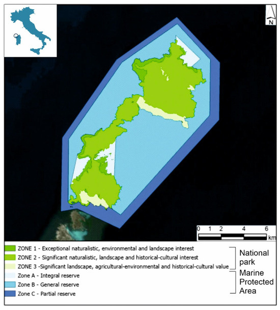
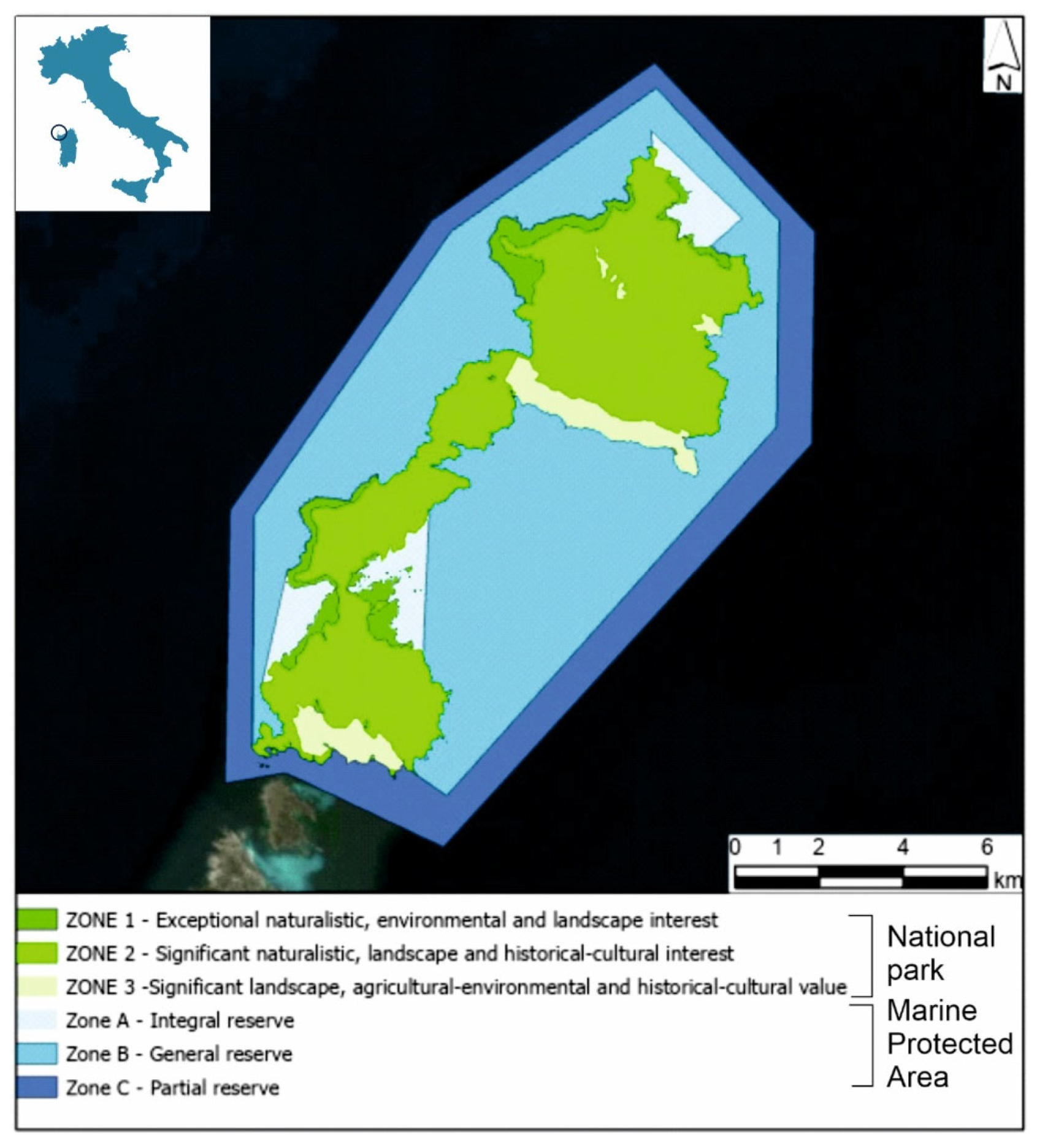
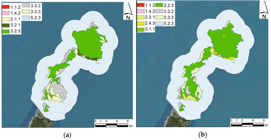
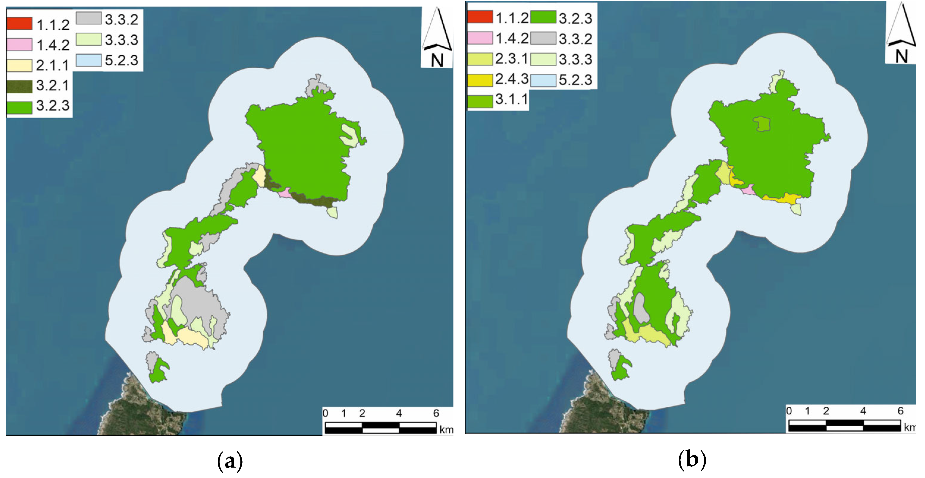
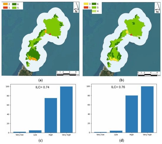
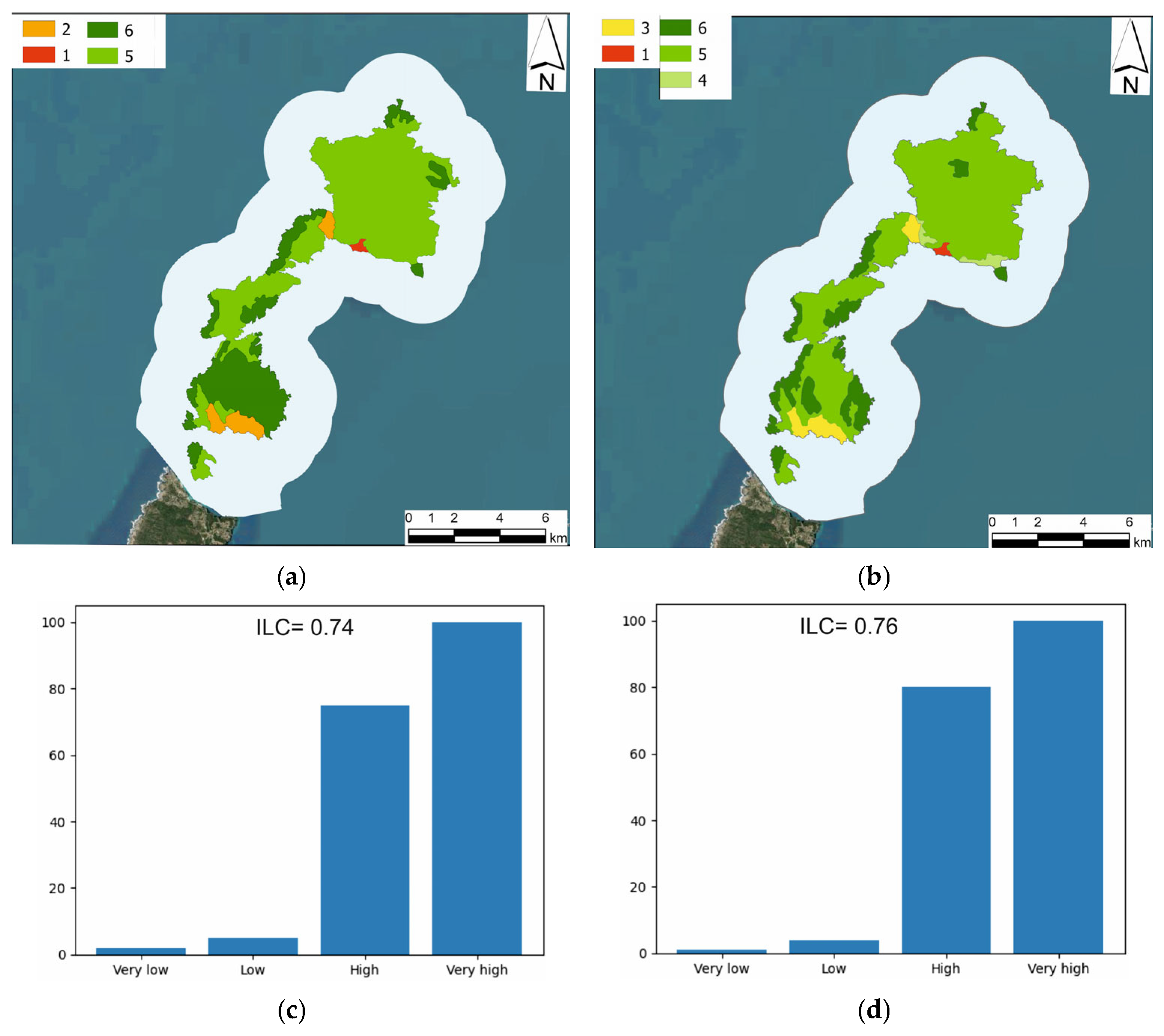
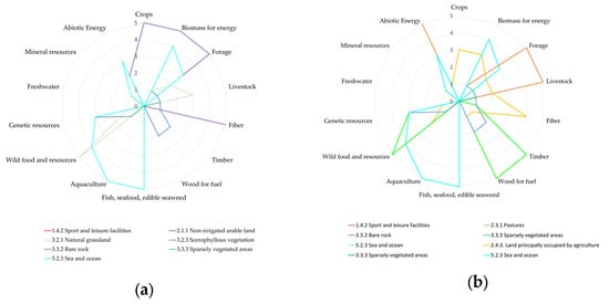
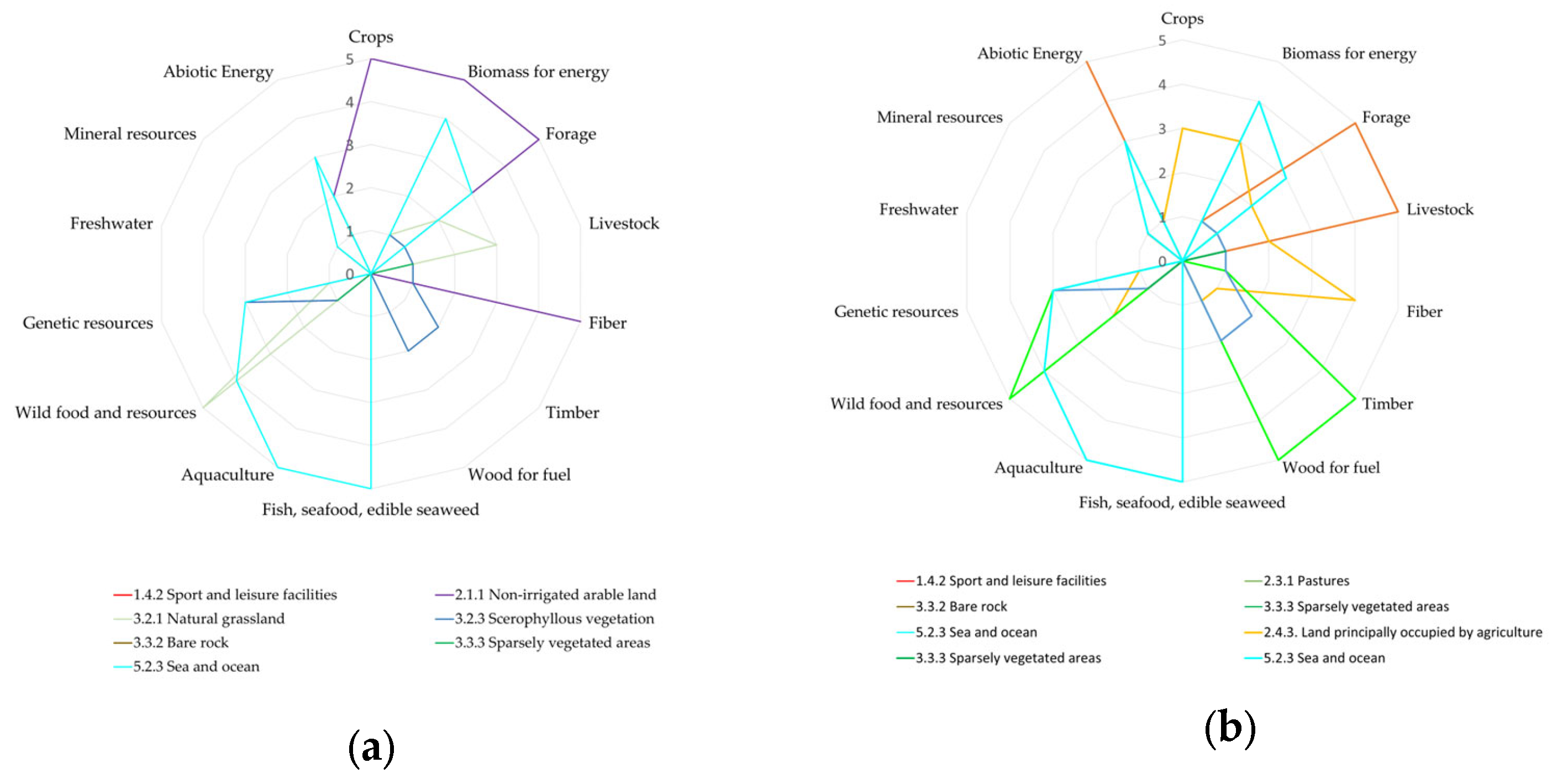
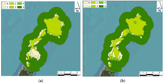
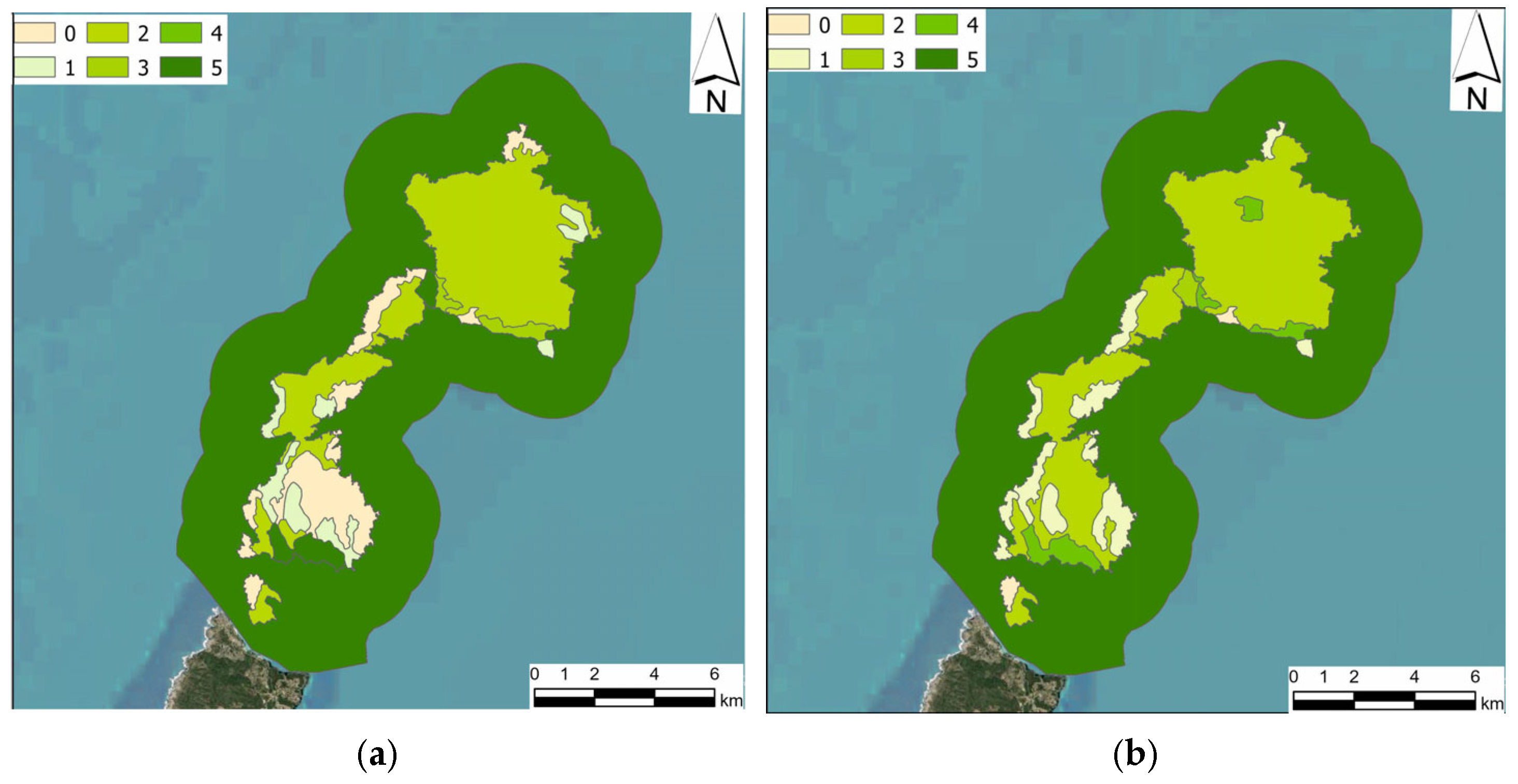
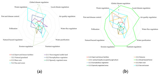
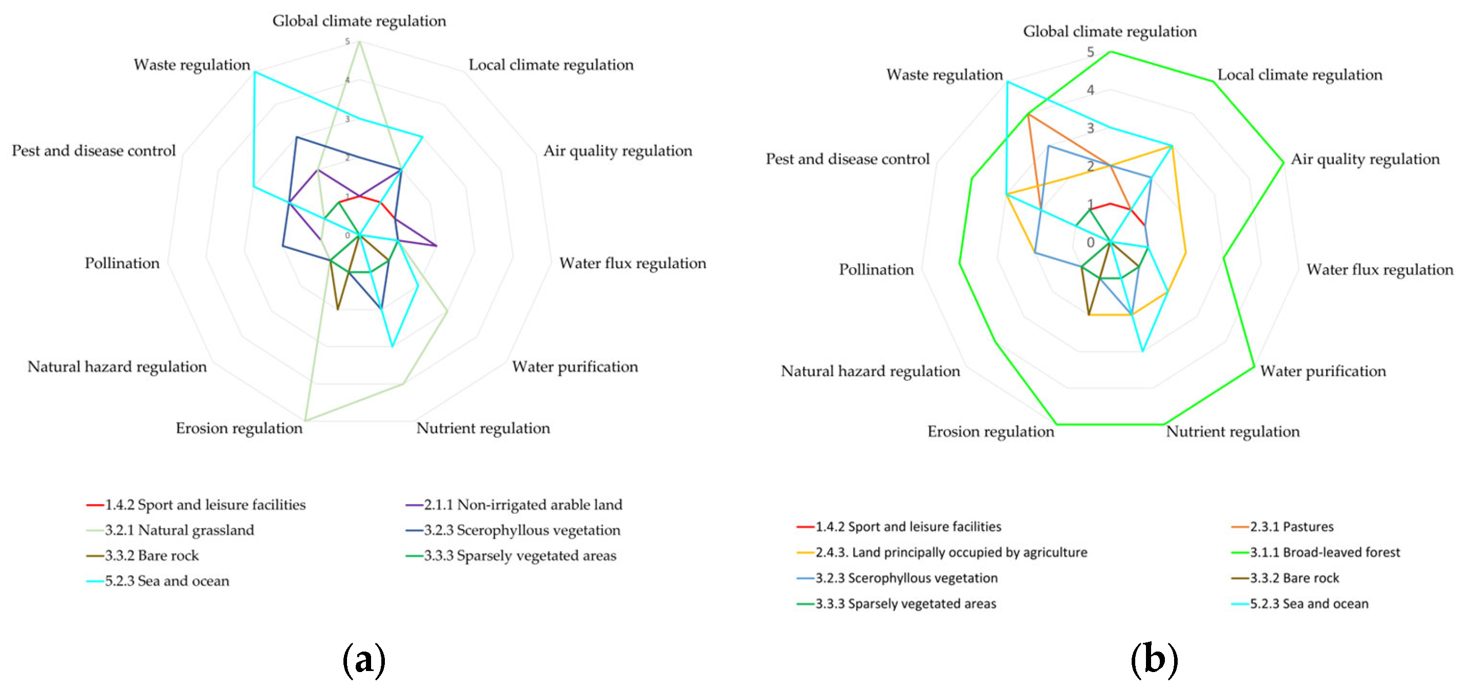
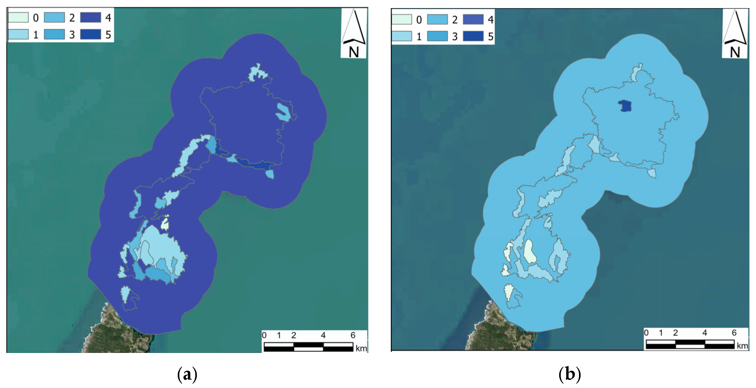
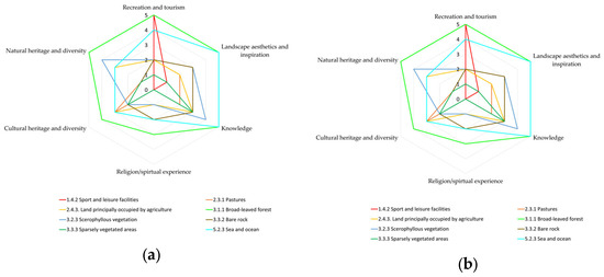
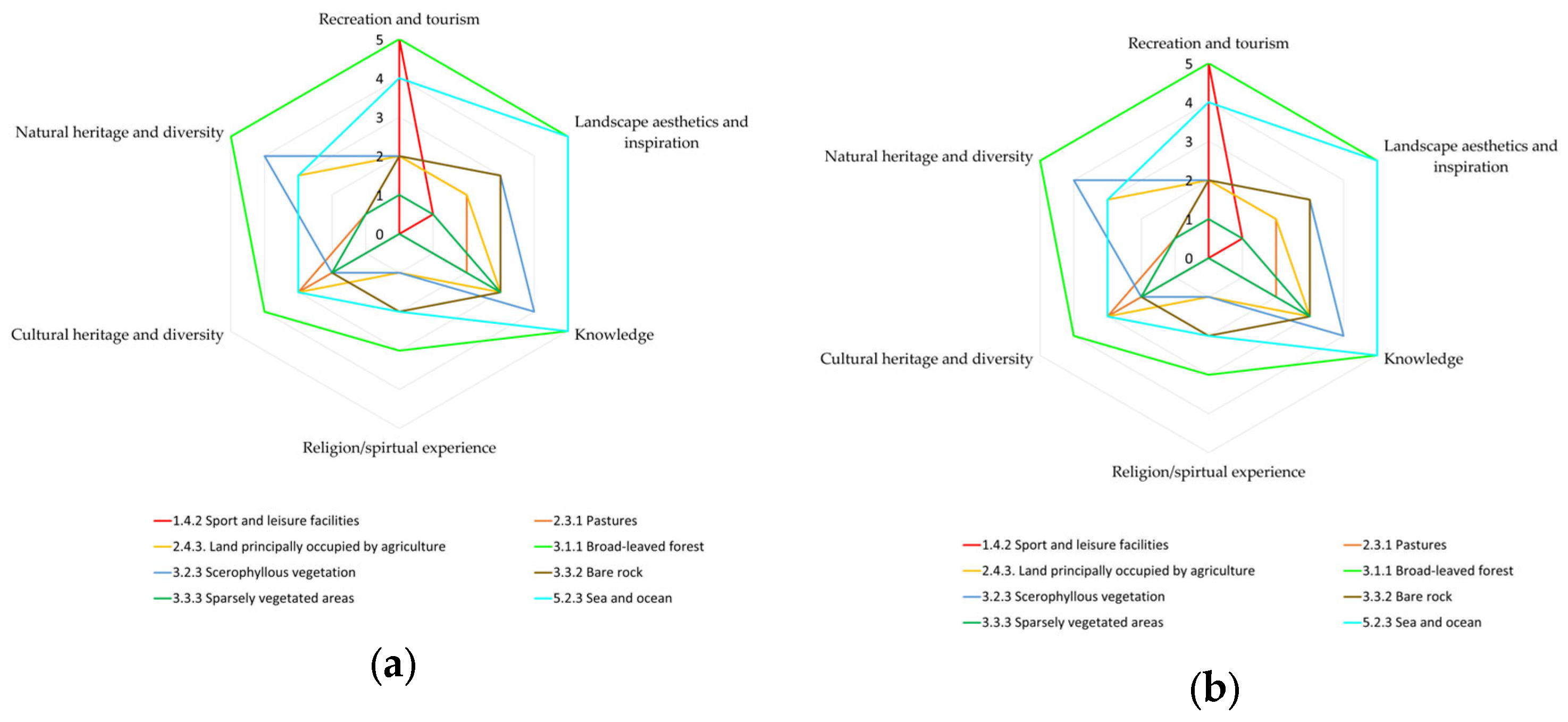
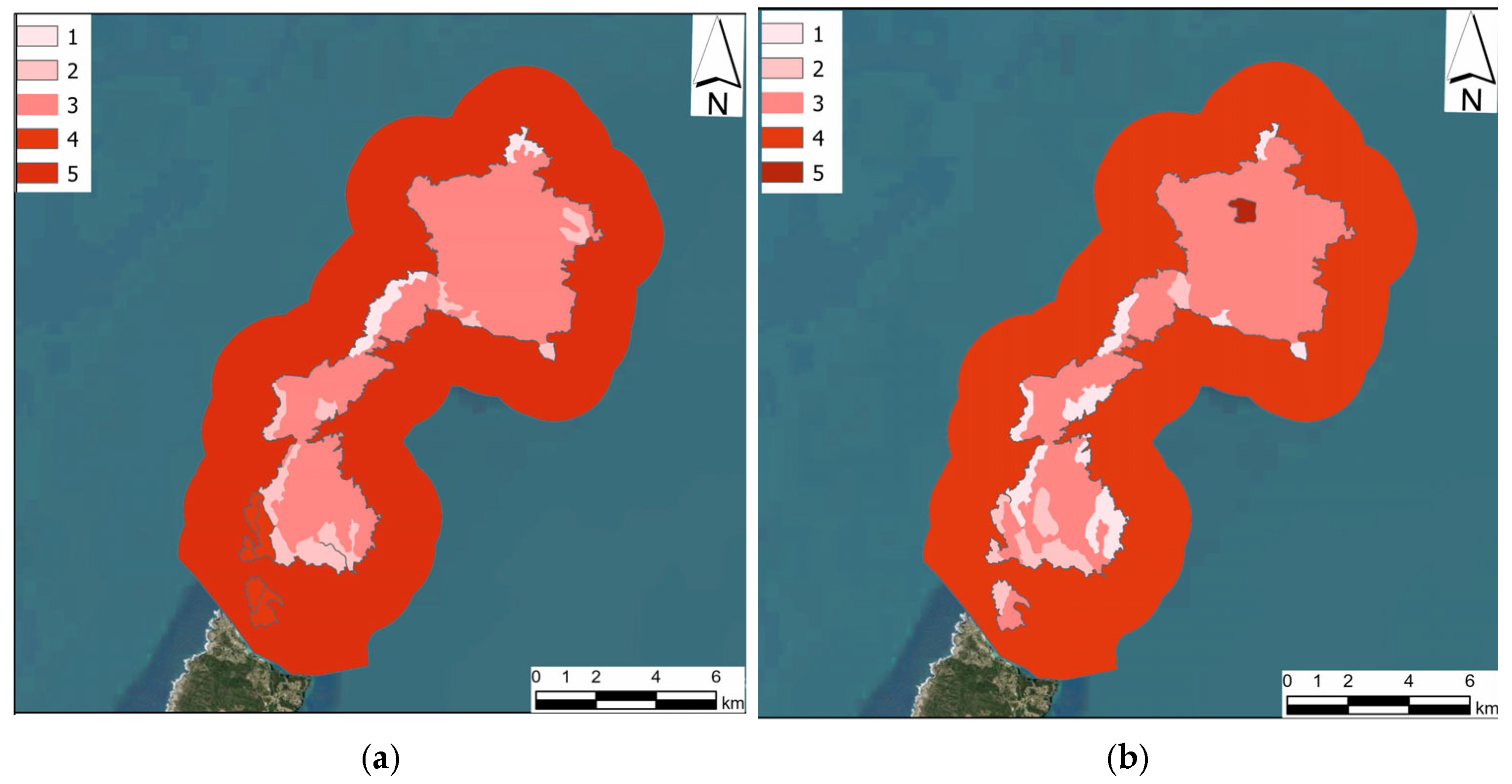
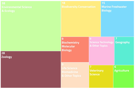
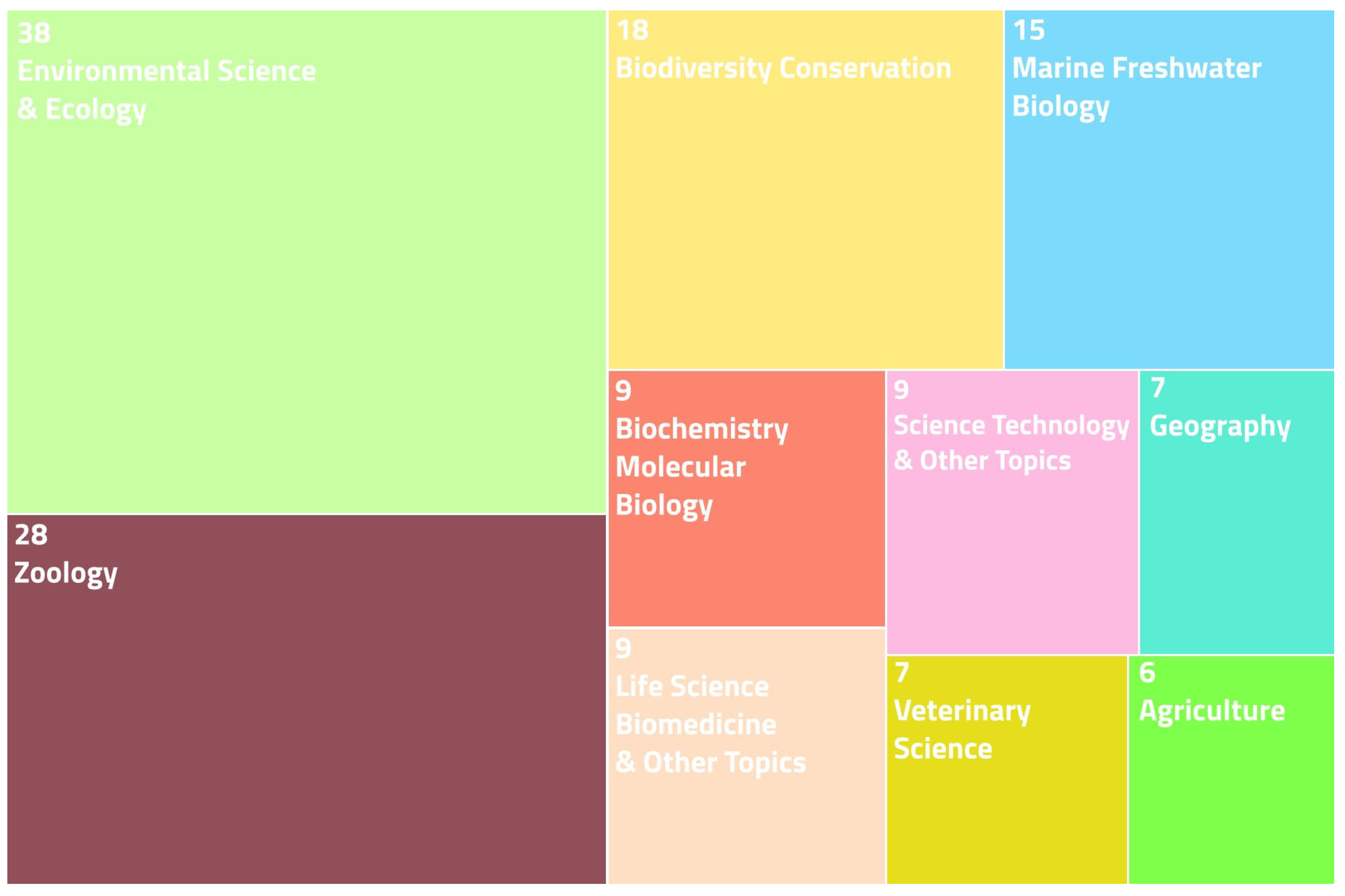
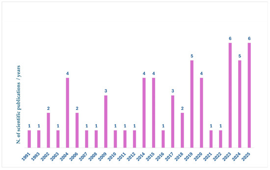
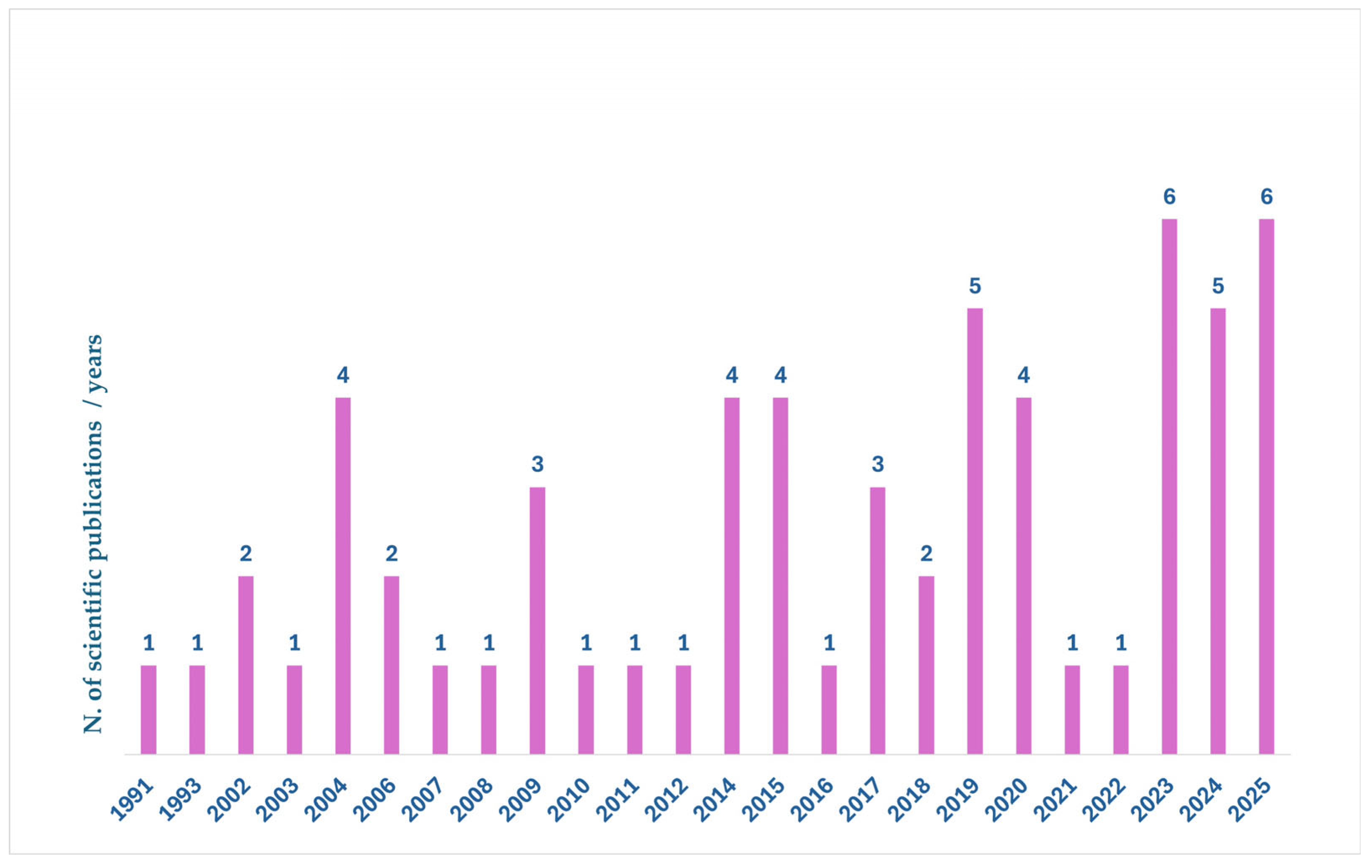

Disclaimer/Publisher’s Note: The statements, opinions and data contained in all publications are solely those of the individual author(s) and contributor(s) and not of MDPI and/or the editor(s). MDPI and/or the editor(s) disclaim responsibility for any injury to people or property resulting from any ideas, methods, instructions or products referred to in the content. |
© 2026 by the authors. Licensee MDPI, Basel, Switzerland. This article is an open access article distributed under the terms and conditions of the Creative Commons Attribution (CC BY) license.