


Abstract
Variations in precipitation patterns during the seasons are expected as a result of climate change, which will affect the hydrological regimes of boreal rivers. Such changes can influence ecological conditions, e.g., by altering suitable habitat areas and the functioning of riparian zones. This study investigates the effects of seasonal flow variations in two regulated boreal rivers on suitable habitat availability for European grayling and on the extent of riparian zones, using hydraulic modelling of both river systems. Grayling habitat suitability was assessed based on previously defined preferences for water depth and flow velocity. Riparian zones were analysed by modelling the inundation period for different discharge scenarios. The simulations were based on representative seasonal discharge scenarios, neglecting daily flow characteristics and sub-daily flow patterns. The results indicate that the ecosystems in both study cases are affected by the projected impacts of climate change. With the increasing annual flow, the grayling habitat areas can be enlarged in Luleälven, while a higher winter discharge and reduced spring flood have a narrowing impact on the riparian zone.
1. Introduction
Rising temperatures and altered precipitation patterns due to climate change affect river flow and riverine ecosystems globally, but regional trends differ significantly [1]. In boreal regions, the annual precipitation is expected to increase [1,2,3]. The temperature in large parts of the boreal zone is increasing faster than the global average [4]. With respect to river flow, this is assumed to lead to an increased annual flow, decreasing seasonality, temporal shifts and an increased frequency of extreme events [1,2,5,6]. The rising temperature will cause a decrease in snow fraction and a snow–rain transition, increasing the winter discharge and decreasing the spring flood [7,8]. The warmer spring temperatures could additionally cause higher infiltration and evapotranspiration rates [6], further decreasing the flood peak, and will lead to a temporal alteration with an earlier snowmelt and an earlier spring flood [7,9]. In glacier-fed rivers, the spring flood might increase until the end of the century before decreasing in the long term [1]. Both, historical observations [10,11] and climate modelling [12,13] indicate the hydrological alteration and shifts in mean flow patterns in boreal rivers due to climate change.
Hydrological alteration evidently adversely affects the fluvial ecosystem [14]. The natural flow regime shapes aquatic and riparian habitat for animals and plants and is thereby essential for supporting biodiversity and ensuring the resilience of riverine ecosystems [15,16]. Hydrological alterations through human action or climate change can influence ecological conditions by altering parameters like lateral connectivity, wetted area, aquatic habitat, structure of the riparian zone or suitability for invasive species [16,17,18].
A common indicator species for cold-water river systems, which has been recorded in the study area, is the European grayling (Thymallus thymallus). It is vulnerable to climate change due to its sensitivity to variations in temperature and flow conditions [19]. Its narrow habitat requirements, particularly regarding water depth and flow velocity, further make grayling a suitable indicator species for ecological assessments [20,21]. Previous studies at the study site have examined how different types of flow variability and substrate alterations may influence the area [22,23]. Seasonal hydrological alteration will furthermore affect the species.
Besides the aquatic habitats, even riparian habitats are strongly related to the flow regime. Rivers with natural flow regimes with large seasonal variations retain wide riparian zones, defined as the temporarily inundated area between high and low water levels within the river system [18]. The riparian zone also includes parts of the upland influenced by groundwater dynamics [18,24]. In contrast, in hydrologically altered rivers, where flow is homogenized due to climate change, production or regulation constraints, the development of riparian areas is limited [25,26,27]. The riparian area plays a critical role in the natural link between aquatic and terrestrial systems [18]. The functioning riparian zones are among the most species-rich habitats for plants in boreal landscapes, underscoring their high ecological importance and creating habitat for numerous animal species [28,29,30].
In regulated river systems, the hydrological alteration due to climate change will add to the hydrological alteration caused by the regulation purposes. The two factors could reinforce or counteract each other’s effect on the discharge and the river ecosystem. The synergistic or antagonistic effect of climate change and river regulation is particularly dependent on the purpose of regulation, which determines the type of hydrological alteration [31]. Regarding hydropower, as the most common regulation purpose in northern Sweden, the literature describes similar patterns of seasonal hydrological alteration for hydropower as for climate change [11,32]. Arheimer et al. [32] show a decreased spring peak and higher winter discharge due to hydropower regulation. Ashraf et al. [10] observed that hydropower and climate change even had a similar degree of hydrological alteration in a case study in Kemi River, Finland. However, there is a lack of studies investigating the combined influence of hydropower regulation and climate change on the river ecosystem. The interplay of these factors in the boreal region is insufficiently understood, leaving the question if flow alteration by climate change and hydropower reinforce or counteract each other.
In this study, we therefore investigate how seasonal flow variation due to climate change impacts the river ecosystems of boreal rivers in northern Sweden and how river regulation interacts with this. The study addresses the following research questions: (1) How will climate change alter seasonal discharge patterns in regulated boreal rivers? (2) How will these alterations affect suitable habitat for European grayling and the extent of riparian vegetation zones? and (3) Can river regulation and adaptive environmental-flow releases mitigate the resulting ecological impacts?
For this purpose, we investigated ecological variables in two different regulated northern Swedish rivers. Based on climate data from the Swedish Meteorological and Hydrological Institute (SMHI), we derived future discharge hydrographs for reaches in Luleälven and Juktån. The predicted hydrographs served as input for our hydraulic models of the study sites. In Luleälven, the influence of climate change-induced seasonal flow alteration on the grayling habitat in a regulated scenario was investigated. In Juktån, we focused on the impact of climate change-induced flow variation on the riparian vegetation, considering an adapted regulated scenario and unregulated scenarios.
2. Materials and Methods
2.1. Study Sites
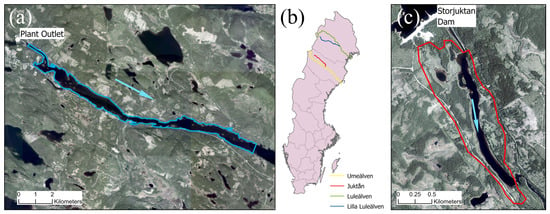
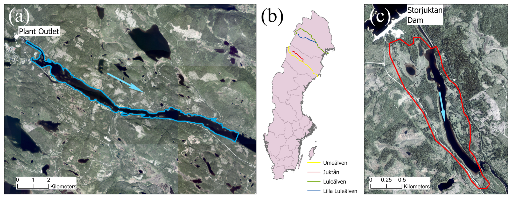
In this study, we investigated river reaches in two different river systems in northern Sweden (Figure 1). The reach Sikselet in Juktån is situated in a bypassed river reach left with an environmental flow. Mattisudden in Lilla Luleälven is a reach in between two hydropower plants, which are part of a larger cascade of plants and is subject to significant hydropeaking and zero-flow events.
Figure 1.
Overview of the study areas (a) Mattisudden, Luleälven and (c) Sikselet, Juktån and (b) their location in Sweden. In (a,c) the blue arrows indicate the flow direction and the polygons the model extent.
Juktån is a tributary of Umeälven in the region of Västerbotten. The river consists of a 2548 km2 catchment and has a natural mean discharge of around 40 m3/s at the confluence with Umeälven [33]. Since the completion of the dam and hydropower plant Juktan in 1978, the majority of the discharge is diverted from the Storjuktan reservoir and discharged directly into the Storuman reservoir in Umeälven. The 68 km of riverbed in Juktån downstream of the dam and until the confluence is the largest bypassed reach in Sweden. In 2021, a seasonally varied minimum flow was implemented, consisting of about 12% of the natural average flow [34]. The study site Sikselet is situated directly downstream of the dam and consists of a 2 km long, slow-flowing reach.
Luleälven river system is the second largest in Sweden regarding the discharge, with a natural mean discharge of 506 m3/s [33]. In 2022, the 15 hydropower plants along Luleälven accounted for 11% of Sweden’s electricity production [35]. The study site Mattisudden is located in the tributary Lilla Luleälven between the most downstream of five power stations, the power stations Akkats and Letsi. The mean discharge in this stretch is 173 m3/s, with a natural mean high discharge (MHQ) of around 800 m3/s [33]. The model spans the 15 km from the plant outlet of Akkats to the reservoir of the Letsi power plant (Figure 1).
2.2. General Approach
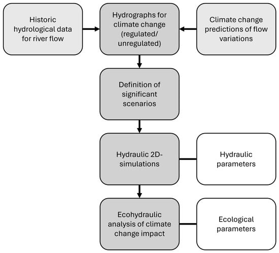
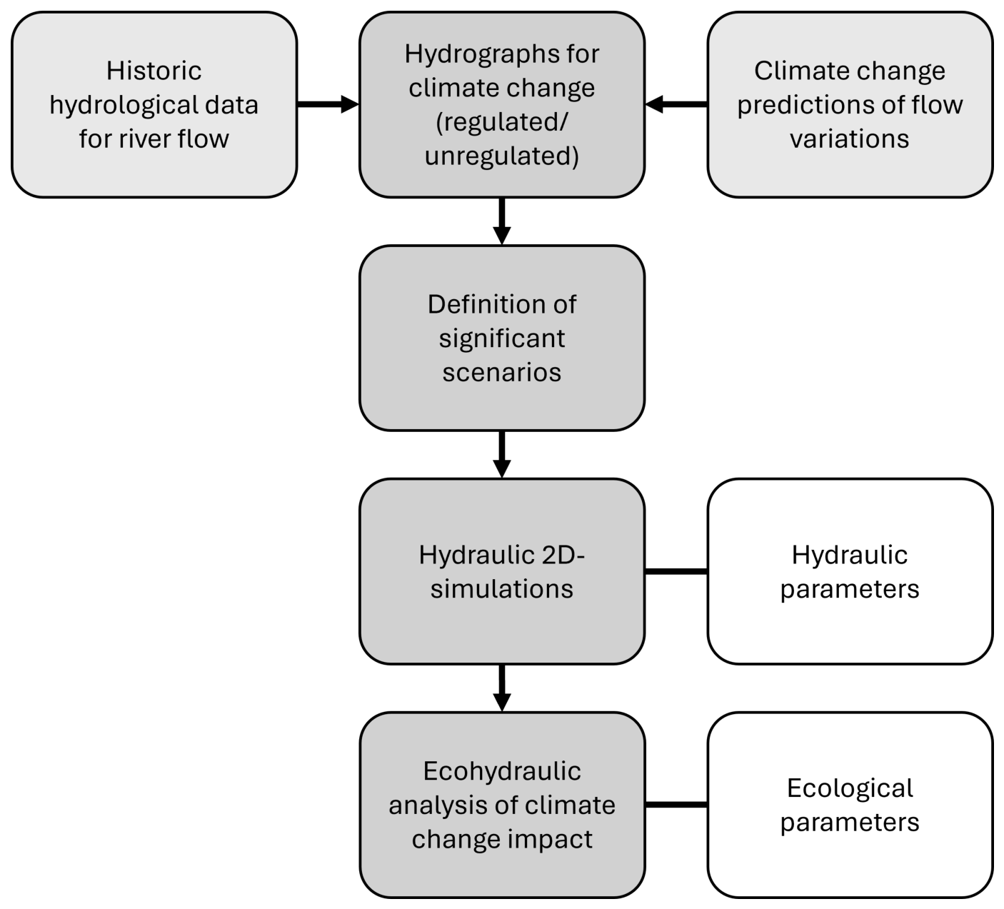
Historical discharge data from gauges in the study site were analysed and combined with discharge change factors obtained from the Swedish Meteorological and Hydrological Institute’s (SMHI) climate change scenario tool [36]. The combination of hydrological data from the reference period and change factors from the climate models resulted in annual discharge hydrographs for the climate scenarios. We identified the most relevant time periods and flows for grayling habitat and riparian vegetation. The significant flow scenarios were subsequently modelled in a two-dimensional hydraulic model to derive key hydraulic parameters. Finally, an ecohydraulic analysis was conducted to assess the potential impacts of climate change on different ecological systems. A schematic of the workflow is shown in Figure 2.
Figure 2.
Schematic overview of the analysis process.
2.3. Hydrological Data and Climate Scenarios
Hydrological data and climate data from the SMHI were combined to calculate the future discharges in the study site, considering different climate change scenarios. The climate change scenarios in this study originate from an article of Van Vuurren [37] and were used in the Fifth IPCC report 2014 [38]. The Representative Concentration Pathways (RCP) describe different pathways of greenhouse gas (GHG) emissions and atmospheric concentrations for the 21st century. In this work, we investigated scenarios based on the RCP4.5 and RCP8.5. The number describes the approximate level of radiative forcing (in W/m2) by the end of the century. RCP8.5 accordingly describes a scenario with high emissions or low effort of emission reduction. RCP4.5 represents an intermediate scenario in the IPCC report.
Based on these climate scenarios, SMHI modelled the change of discharge in Swedish rivers until the end of the 21st century in relation to the reference period 1971–2000. They provide average change factors for the discharge (Q change) on an annual and monthly base for the periods 2001–2040, 2041–2070 and 2071–2100 along with data on the variability of their simulations [36]. The data are based on simulations with the S-HYPE hydrological model forced by an ensemble of regional climate models (RCM) from EURO-CORDEX. The ensemble comprises 12 combinations of global climate models (GCMs) and RCMs for each emission scenario (RCP4.5 and RCP8.5). Climate data originate from CMIP5 global climate models, dynamically downscaled using regional climate models (e.g., RCA4, HIRHAM5, RACMO22E, REMO and ALADIN). The climate data were bias-adjusted by SMHI prior to hydrological modelling [39]. Table 1 shows the average, maximum and minimum change factors for mean annual discharge, calculated relative to the 1971–2000 reference period, for both study sites and both climate scenarios.
Table 1.
Percentage change of the annual discharge according to RCP4.5 and RCP8.5 for the Lilla Luleälven and Juktån for the years 2071-2100 compared to the reference period 1971–2000.
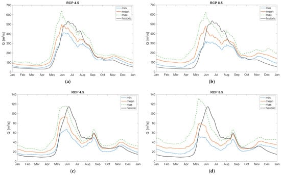
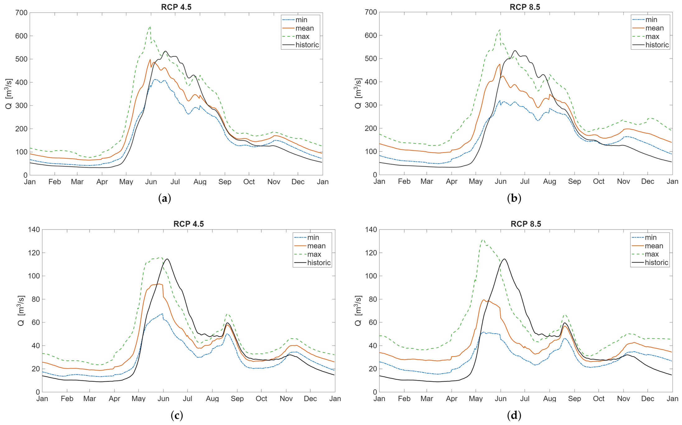
We used the monthly change factors for the time period 2070–2100 to calculate discharge hydrographs for both study sites, assuming unregulated conditions (Figure 3). As Sikselet in Juktån has been regulated since 1978 and Mattisudden in Lilla Luleälven since 1973, data from the hydrological model S-HYPE by SMHI for the period 1991–2000 [40] were used as reference data for the calculations. The monthly change factors from SMHIs climate change scenario tool were interpolated using a piecewise cubic hermite interpolating polynomial. In a last step, the values for each month are renormalized to correct biases introduced by the interpolation of the monthly averages.
Figure 3.
Hydrographs for the climate scenarios RCP4.5 and RCP8.5 for Lilla Luleälven (a,b) and Juktån (c,d) under the assumption of unregulated conditions.
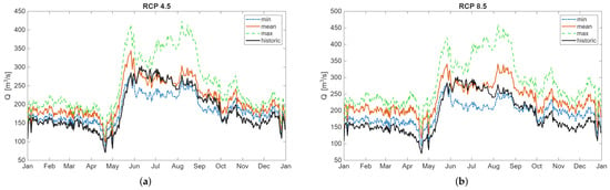
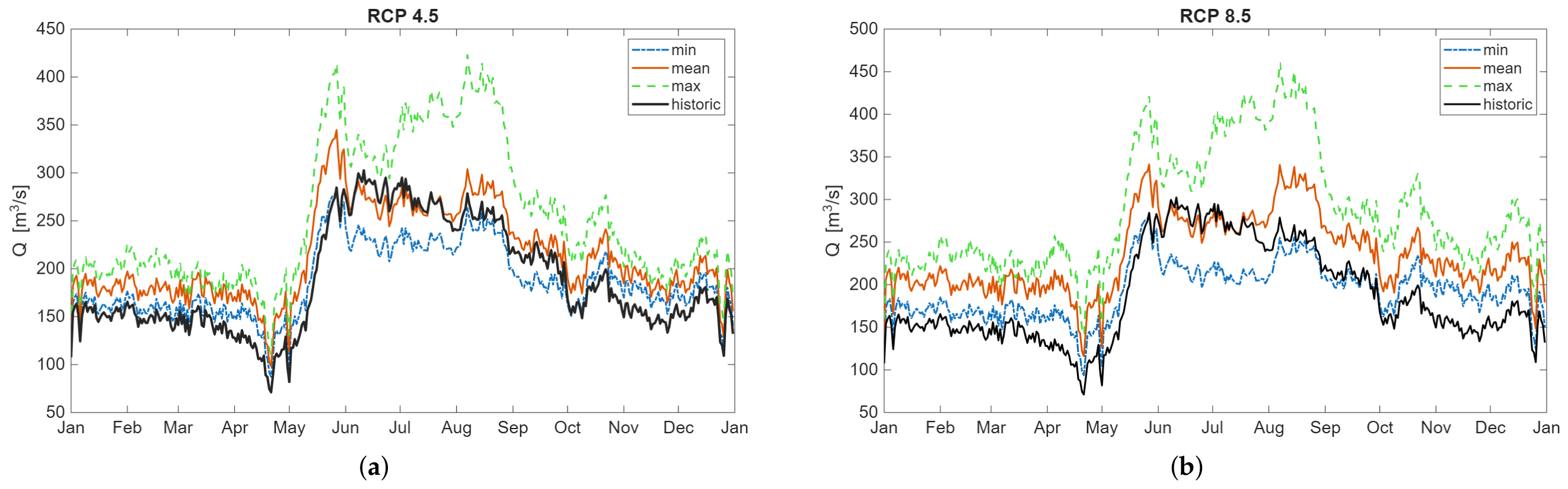
SMHI also provides change factors for the future river discharge considering climate change and a regulation scenario comparable to the current regulation [36]. The regulation leads to a more homogeneous flow over the year. Based on these monthly change factors and the regulated reference hydrographs, climate projections are calculated for Mattisudden in the same way as for the unregulated cases and presented in Figure 4. These data were subsequently used to conduct habitat analyses for different life stages of grayling. The use of daily average discharge values and monthly average change factors in our study prevents the detailed analysis of sub-daily and short-duration flow patterns. Derivation of a regulated climate projection for Sikselet, Juktån was not pursued, given that the reach is a bypassed reach steered by an environmental minimum flow instead of the full annual discharge. A possible increase in spill events due to an increase in extreme events was not investigated.
Figure 4.
Hydrographs for the climate scenarios RCP4.5 (a) and RCP8.5 (b) for Lilla Luleälven under the assumption of current regulation scenario.
2.4. Hydraulic Simulations
Two-dimensional hydraulic models were generated for both study sites using the D-Flow module of the Delft3D Flexible Mesh suite (version 2025.01, Deltares, Delft, The Netherlands) [41], which utilizes a finite-volume solver to solve the depth-averaged Navier–Stokes equations applying the shallow-water and Boussinesq assumptions [42]. The simulation time step is based on the Courant criterion, using a default Courant number of 0.7. The computational domains were discretized with the help of a flexible mesh generated in the RGFGRID module in Delft3D-FM. The meshes consist of rectangular elements in the main channel and triangular elements in adjacent areas [22,26]. The upstream boundary condition in both models was defined as a discharge condition based on the historical discharge data and the climate projections. The downstream boundary was specified as a fixed elevation of the water surface. The models were calibrated using a parametric sweep of the Manning roughness. In Mattisudden, field data on water surface elevations and velocities were available for calibration. In Sikselet, only water surface elevations were available for calibration. Mesh sensitivity analyses have been conducted in previous studies for both study sites [22,26] to quantify and limit uncertainties.
2.5. Grayling Habitat
For the analysis of grayling habitat, Luleälven was selected as the study site, as this reach is strongly influenced by hydropower regulation and supports a documented population of European grayling. The inlet discharge was selected from Figure 4, as it represents projected future discharges under different climate scenarios. These discharges were analysed using previously established habitat preference values for European grayling at different life stages (Table 2), with data adapted from [20,21,43,44,45]. For each life stage, the corresponding discharge was selected based on the season associated with that stage under the assumed RCP scenarios.
Table 2.
Grayling habitat preferences for different life stages (Data from [20,21,43,44,45]).
Grayling exhibit distinct habitat preferences across life stages. During the spawning and larval stages, which occur in spring, grayling prefer shallow water depths and low flow velocities; the inlet discharge for spawning habitat simulations was taken from the spring flood. During the summer foraging stage, grayling prefer greater water depths and higher flow velocities, and the lowest summer discharge for each scenario was selected as the inlet discharge. During the wintering stage, grayling occupy the deeper parts of the river; this preference was accounted for in the habitat analysis during modelling, with inlet discharges for autumn and winter derived from the predicted seasonal flows.
According to earlier studies, European grayling exhibit seasonally varying habitat preferences [46]. During autumn and winter, grayling tend to gather in deeper areas and deep pools, which may act as population bottlenecks if these areas are subject to fishing pressure [46] or if hydropower regulation affects them through fluctuations in water levels.
2.6. Riparian Vegetation
For the simulation of riparian vegetation, the method from Höller et al. [26] was used to couple hydraulic simulations in Sikselet with inundation data for riparian species. The data from Ström et al. [47] present data on the inundation tolerance of riparian vegetation belts in boreal rivers. The thresholds for the inundation period during the growing season for the four different vegetation belts can be used to derive the significant discharges from the average annual hydrographs. By simulating these discharges, the inundated areas define the extents of the riparian vegetation belts. The lower border of the riparian zone is defined by the lowest discharge during the year, separating the riparian from the aquatic zone. The four vegetation belts and their inundation thresholds can be found in Table 3.
Table 3.
Riparian vegetation belts and their tolerated period of inundation during the growing season (Data from [47]).
The growing season is assumed to be May 1st until October 1st for the historical cases based on temperature data from SMHI for Juktån. SMHI’s climate projections show that the growing season is projected to start approximately 10–20 days earlier and end 10–20 days later for the RCP4.5 and accordingly 20–30 days earlier and later for the RCP8.5 [36].
2.7. Simulation Scenarios
In the Mattisudden site, a change of natural flow due to climate change will necessarily affect the regulated annual flow. Considering the hydropower cascade, consideration of the unregulated flow in the reference period and for climate change projections seems not appropriate. We therefore concentrated on the regulated scenarios derived based on SMHI data. For the evaluation of grayling habitats and their alteration, we simulated the spring flood events, the low summer discharge and the winter discharge for the different climate projections and the reference scenario.
In the reach Sikselet, the current minimum flow (CMF) with seasonal variation was implemented in 2021 after being decided on by an environmental court. Assuming that this court decision will endure, we consider the CMF as a minimum condition for future discharge into the bypassed reach. An increase in the annual discharge due to climate change (see Table 1, −1.56 to +28.06%) would therefore furthermost result in an increased hydropower production and diversion into Umeälven. The discharge into the bypassed reach Juktån could be increased by a possible increase in spill events or a governance action to change the CMF. To investigate the potential impact of climate change, we considered the CMF regulation as a minimum condition and defined two other regulation scenarios increasing the flow volume into the reach Juktån in favour of environmental purposes. Both scenarios are based on adding the annual surplus of discharge due to climate change onto the CMF and distributing it seasonally according to the current hydrograph. In the first scenario, the annual surplus for RCP4.5 mean (+10.74%) is added on the CMF (CMF + surplus RCP4.5 mean). The second scenario represents the annual surplus for RCP8.5 mean (+16.31%) (CMF + surplus RCP8.5 mean). As additional scenarios, we investigated the unregulated climate scenarios RCP4.5 and RCP8.5, which would equal a termination of hydropower operation. The unregulated scenario was simulated for mean, minimum and maximum projections of both RCPs. The potential natural flow in the reference period was taken as reference scenarios. All these scenarios and projections were used to investigate the impact of climate change on the riparian vegetation in Juktån.
3. Results
3.1. Change of Flow and Impact on Regulation Schemes
The projections from SMHI indicate an increase in annual discharge in both studies for the two climate change scenarios, RCP4.5 and RCP8.5. Only the minimum projection for Juktån and scenario RCP4.5 would mean a slight decrease in annual discharge by 1.56% (Table 1). Regarding the sub-annual alteration of flow by climate change, an increase in the winter discharge is given for the unregulated cases in both RCPs. In the projection of summer discharge, the SMHI data show large uncertainties. The mean and minimum projections for the unregulated cases describe a clear decrease of the spring flood, while the maximum projection even includes a small increase. Due to the higher temperatures and earlier snowmelt, the spring flood is projected to occur earlier in all scenarios.
How will this alteration of the natural flow due to climate change impact the hydropower production? In general, the shift of discharge from summer to winter should benefit the hydropower production. Historical data show how the hydrograph in regulated rivers in boreal regions is already more uniform than the natural one [16,32,48]. This already existing flow alteration in the regulated rivers in northern Sweden dampens the effect of climate change on the river discharge. The projections in Figure 4 show an increase in winter discharge and spring flood for the regulated scenarios for Luleälven. The effect on the discharge in the months June to September is more ambiguous. The maximum projections show a clear increase in discharge, while the minimum prediction shows a decrease in discharge, and the means show good agreement with the reference scenario.
In Juktån, the hydropower production does not directly impact the downstream flow because of the diversion plant. Instead, a seasonal minimum flow is defined. A change in production patterns will directly affect the discharge to Storuman reservoir (Umeälven) but not into the bypassed Juktån. Thereby, hydropower production and an increase in the minimum flow for ecological purposes in Juktån compete for the additional annual discharge due to climate change.
3.2. Impact on the Riparian Vegetation
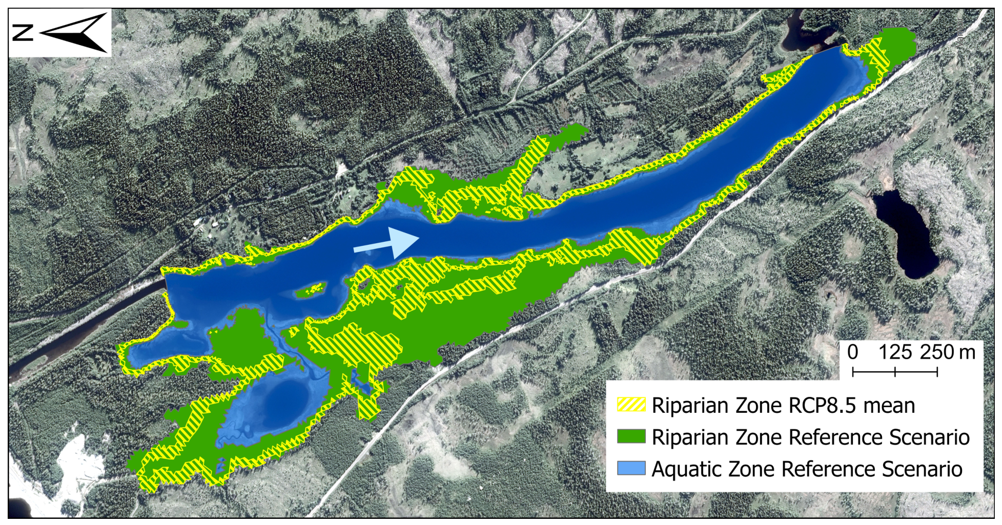
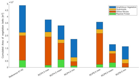
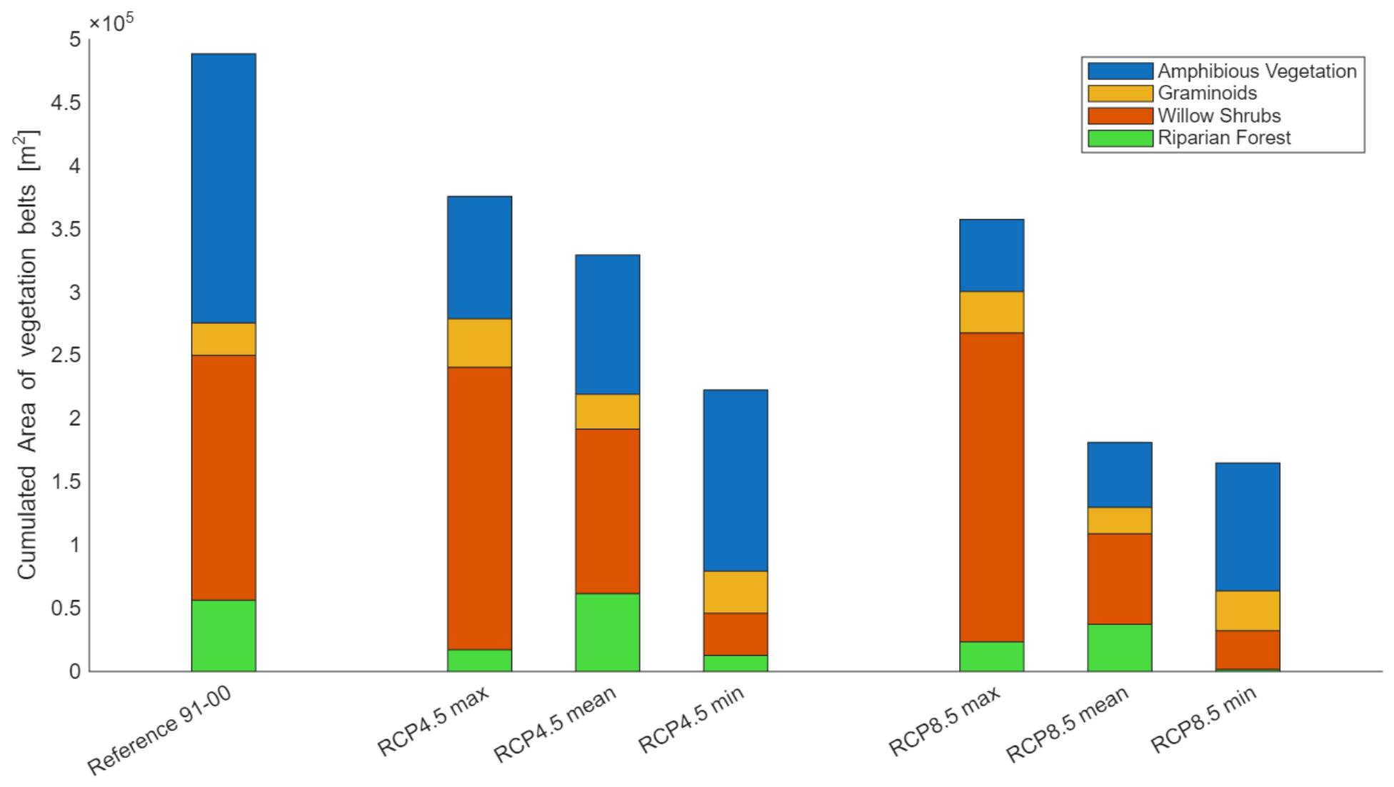
Considering unregulated flow conditions in Juktån, our ecohydraulic simulations project decreased riparian areas for the climate scenarios compared to the reference scenario (average of the years 1991–2000). Due to the higher winter discharges in all six climate projections, the permanent aquatic area is expected to increase. At the same time, the lower flood peak in most of the projections would lead to a narrowing of the riparian zone from the terrestrial side (see Figure 5). The total riparian area is projected to decrease by 23% (RCP4.5 max) to 66% (RCP8.5 min) in the study reach (see Table 4). The projected amphibious area decreases for all six unregulated projections compared to the reference scenario, while the other vegetation belts show more ambiguous behaviour as shown in Figure 6. Compared to the reference scenario, the area of the graminoid belt is projected to change with −19% to +50%, willow shrubs with −83% to +26% and the riparian forest with −97% to +9%.
Figure 5.
Simulated riparian area for the reference flow and the RCP8.5 mean scenario. The blue arrow indicates the flow direction (Background image: Orthophoto © Lantmäteriet [2018]).
Table 4.
Total riparian area for the different scenarios, normalized [-] with the riparian area in the reference scenario 1991–2000.
Figure 6.
Simulated riparian area and area of vegetation belts for the different climate scenarios in unregulated conditions.
A previous study by Höller et al. 2025 [26] projected the riparian area for the minimum flow currently implemented in Juktån. The results show that the total riparian area normalized with the reference scenario 1991–2000 is 0.15 (Table 4). The potential regulation scenarios using the surplus in annual flow due to climate change for increasing the seasonal minimum flow result in a normalized total riparian area of 0.49 and 0.54, respectively. The projected total riparian area for these scenarios would thereby be larger compared to three of the climate scenarios regarding unregulated flow.
3.3. Impact on Grayling Habitat
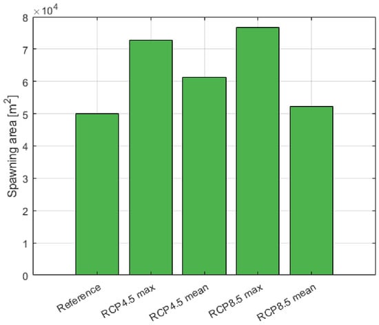
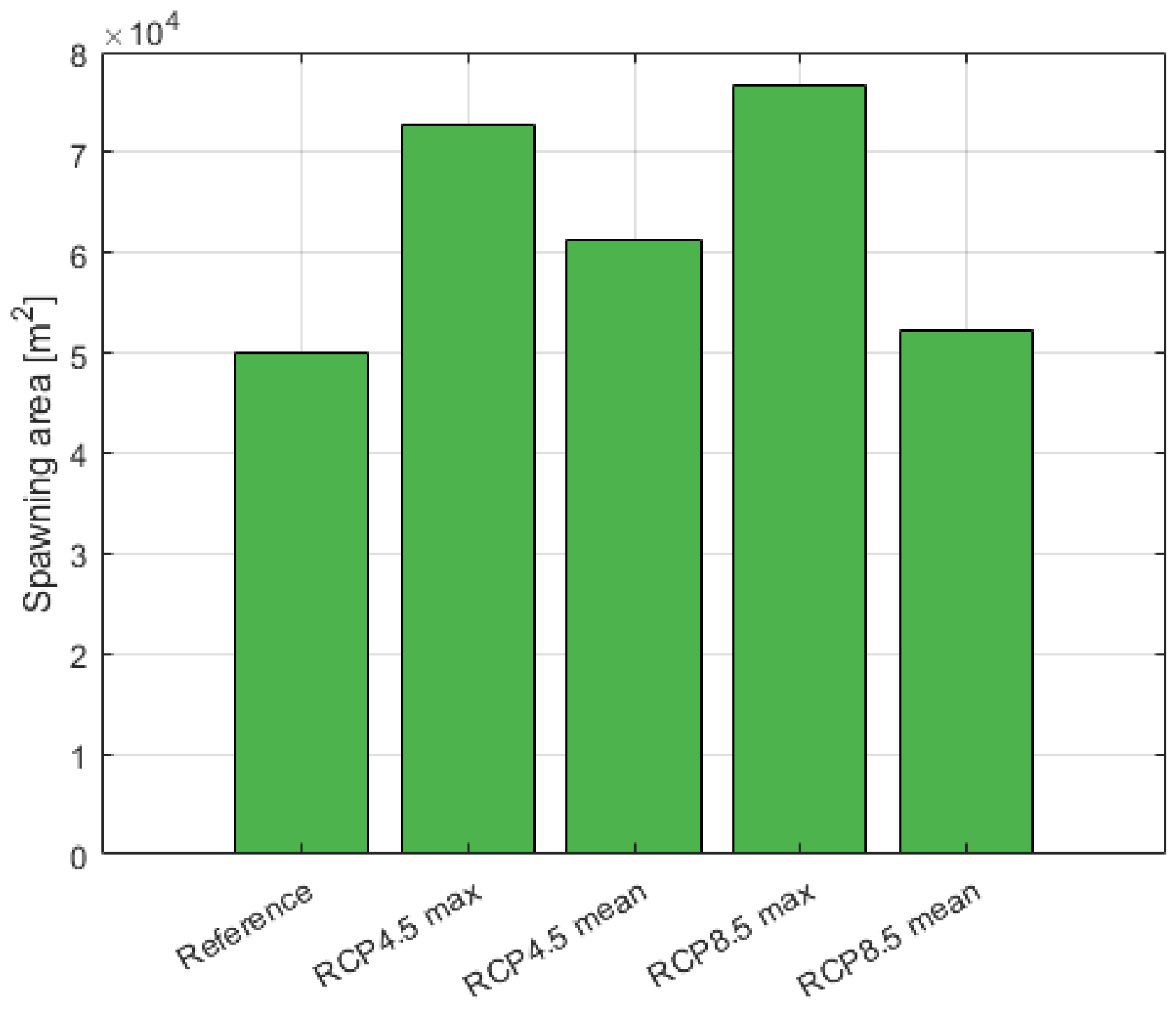
For continued regulation of the river system, spawning areas were defined on the basis of the calculated discharges under the different climate scenarios. Scenarios that showed the largest differences in flow were simulated, and suitable habitat areas were quantified for each flow condition. Figure 7 illustrates the suitable spawning areas for each climate scenario, including a comparison with the reference discharge. Across all scenarios, the assumptions indicate an increase in spring flood discharge, which, in turn, results in an expansion of suitable habitat area, assuming that the downstream water level remains constant. For both RCP4.5 min and RCP8.5 min, the differences in discharge were small; these scenarios were considered comparable to the reference scenario and are not shown in the figure.
Figure 7.
Suitable grayling spawning areas for different climate scenarios during regulated conditions.
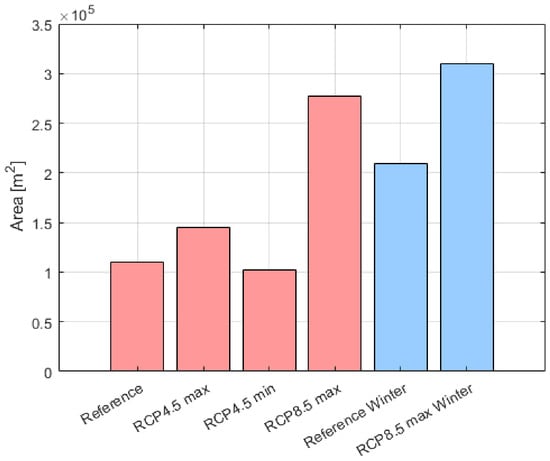
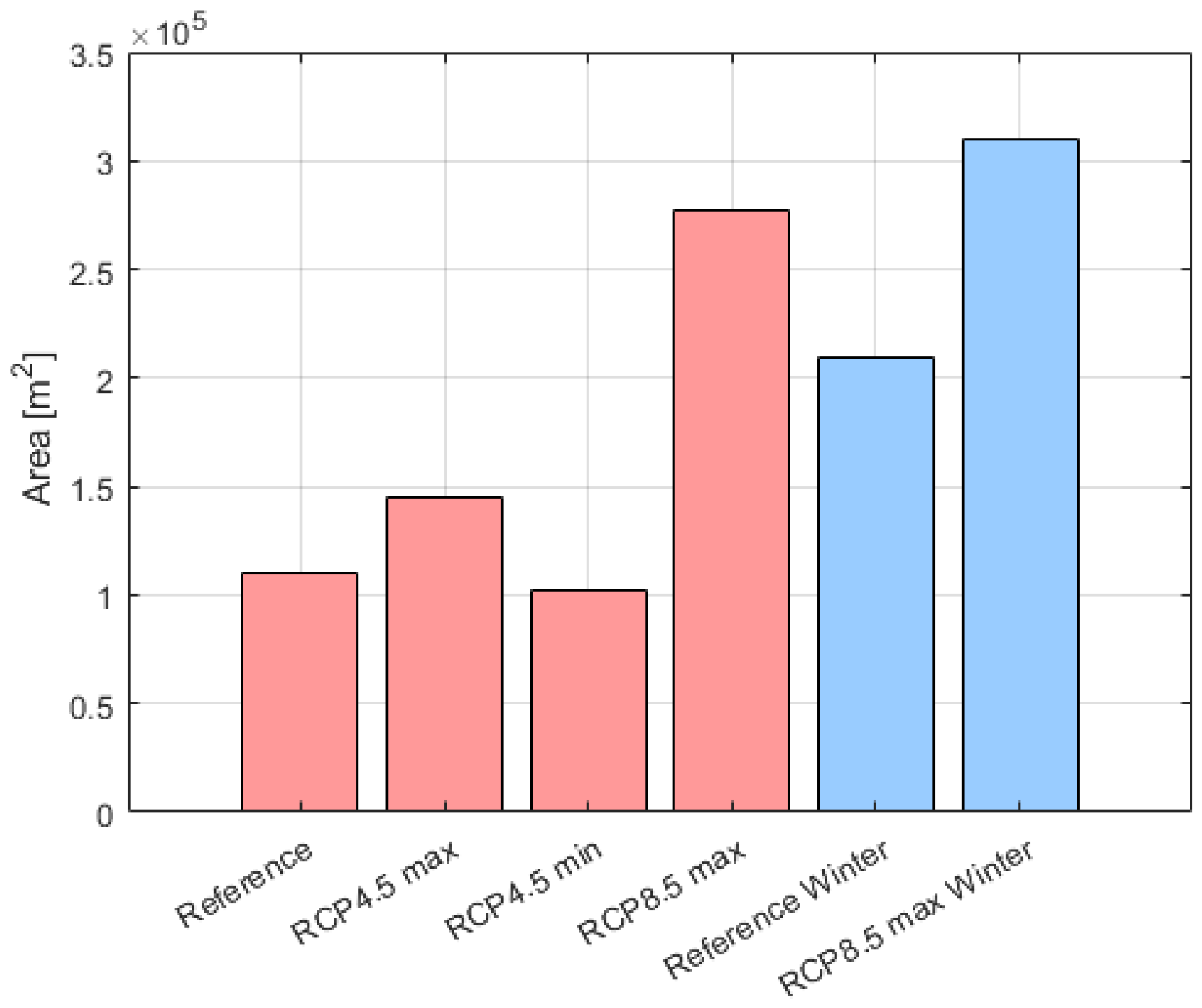
Suitable foraging habitat for grayling was assessed using simulations based on the same assumptions, focusing on the lowest summer discharge, which occurs in August, as shown in Figure 4. These discharges were simulated, and foraging preference criteria from Table 2 were applied to define suitable habitat areas. The results indicate a reduction in suitable habitat for the RCP4.5 min scenario, and the RCP8.5 min close to this, and an increase in habitat area with higher assumed discharges as seen in Figure 8.
Figure 8.
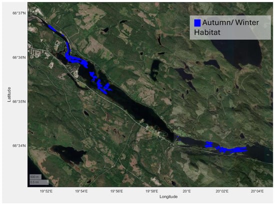
Suitable grayling foraging (red) and wintering areas (blue) for different climate scenarios during regulated conditions.
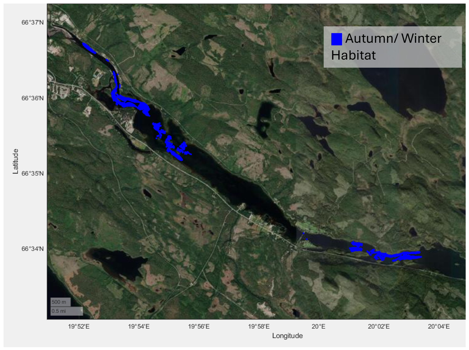
Wintering habitat was also evaluated under the RCP8.5 max scenario, as winter discharges are assumed to exceed the reference value. The results are simulated before ice covering. This increase in discharge results in an expansion of suitable wintering habitat, under the assumption that downstream water levels at the dam remain constant across all scenarios, see Figure 8.
The warmer temperatures in all scenarios, which already reflected in the longer growing season (see 2.6), will also have an effect on ice cover, hydropower operation and flow variations during winter. In all scenarios, a higher flow is projected in the Luleälven during winter. Earlier studies have been conducted on spawning habitats [22,23,49]. The autumn and winter areas before the ice cover for RCP8.5 are presented in Figure 9. As seen in Figure 4, the discharge is projected to increase during winter under the assumption that the river is still regulated.
Figure 9.
Suitable grayling wintering habitat areas during RCP8.5 max scenario (Background image: World imagery by Esri, Vantor, Earthstar Geographics and the GIS User Community).
Although the habitats selected by grayling during autumn and early winter are relatively unknown, studies indicate that grayling tend to move towards deeper areas with low flow [44,46,50]. These studies do not document their distribution at temperatures below 0 °C, which supports modelling the river only before ice cover. Research has shown that salmonids generally move short distances during colder periods, but their movements can be triggered by gradual changes in ice cover [51,52,53], suggesting that climate change, through alterations in discharge, will also affect available habitat areas. The autumn and early winter habitats are typically located in the deeper and central sections of the river, and the modelled result for RCP8.5 max can be seen in Figure 9.
4. Discussion
4.1. Seasonal Alteration of Flow Through Global Warming
Climate change affects the discharge in boreal rivers not only through changes in the annual flow but even through seasonal redistribution of flow, with especially the later having major impacts on river ecosystems. The future increase in annual flow (see Table 1) in the boreal region is a result of increased precipitation. This is caused by the elevated transport of vapour from lower latitudes and the higher specific humidity of the warming troposphere [54]. The seasonal change in flow patterns in the climate scenarios (see Figure 3) can be explained by warming temperatures leading to a transition of precipitation from snow to rain. The winter discharge increases due to a larger share of rain during the winter months [55]. The spring flood decreases in magnitude as a result of the reduced snow storage and precedes in time as a result of warmer temperatures. Furthermore, the warmer temperatures and increased evapotranspiration affect the summer flow. Our climate hydrographs present these patterns in good agreement with literature [6,56]. The maximum climate projections slightly contradict the findings by showing an increased magnitude in spring flood. This might be a result of the substantial increase in annual precipitation, which even could lead to an increased snowpack [57]. However the maximum projections clearly incorporate the other expected changes in flow patterns. In general, the hydrographs presenting the climate scenarios reveal large uncertainties in the climate projections by SMHI regarding the span between minimum and maximum values. Such uncertainties in climate projections are common as they represent complex physical processes and natural variability and are the result of an ensemble of climate models [2,58]. We handled the uncertainty by using the interval of projections (minimum, mean and maximum) instead of single curves, which would imply wrong precision in terms of climate modelling. The uncertainty of climate data nevertheless limits the predictiveness of our ecohydraulic results. Another limitiation is the averaging of daily discharges for the reference period and the use of interpolated monthly values for flow changes leading to an underestimation of flow peaks in the reference scenario as well as a neglection of sub-daily and short-term flow patterns in the climate hydrographs. The effects of extreme events, for example, due to heavy rainfall, which are expected to become more frequent, can not be analysed in our study. Consequently, our climate hydrographs indicate a loss of seasonal variation in flow and an increase in annual flow, which is transferable to other snow-fed rivers in the boreal region. They do not incorporate any short-term flow events, and the quantitative changes are reach-specific and subject to uncertainties resulting form the climate models.
4.2. Effects of Hydropower Operation on Climate Change Flow Projections
In the regulated river systems in northern Sweden and globally, river regulation, e.g., for hydropower operation, transforms the natural discharge hydrographs. Hydropower operation might decouple, reinforce or counteract the climate-driven alteration of natural flow seasonality.
In Mattisudden, Luleälven climate change and hydropower operation both tend to homogenize the natural snow-melt dominated flow. Historical operation (see Figure 4) shows an attenuation of the spring flood, when water is stored in the reservoirs during spring and summer to then drive electricity production during the winter months when demand is high [10,32]. Figure 4 shows that, in our climate projections, considering the current regulation, the winter discharge will increase, while no clear trend can be seen for the summer months. Considering the minimum and mean projections, climate change seems to reinforce the attenuation of seasonal variation introduced by hydropower operation.
In the historical hydrograph (see. Figure 4), the daily averaging of discharges eliminated short-term regulation, e.g., hydropeaking. The monthly average change factors, which the climate projections are based on, further smoothed the hydrographs reducing flow peaks and hiding hydropeaking events. Hydropeaking, as a measure to balance the energy grid, will most probably increase in the future [59], when fossil energy sources are phased out and the more intermittent renewables take a larger share of the energy production. The neglection of such sub-daily and short-term flow events limits our analysis to seasonal patterns. More limitations of the regulated flow projection are found in the uncertain future energy demand, market mechanisms and reservoir capacities, which could impact hydropower operation in various manners. The climate scenarios for Mattisudden strongly indicate that hydropower production will benefit from the higher winter discharges due to climate change enabling more production in this energy-intense part of the year.
In Juktån, the bypassed reach is primarily controlled by its prescribed minimum flow. Additional runoff or seasonal changes in runoff will not automatically affect the reach as they might be diverted to hydropower production. In contrast to the hydropower cascade in Luleälven, the diversion plant in Juktån decouples the downstream flow from hydrological changes caused by climate change. The hydrological alterations proposed in Section 2.7 and Section 3.2 would therefore require management decisions but could be motivated by environmental legislation [48,60] or future market incentives. An exemption from the decoupling might be extreme events where spill into the bypassed reach can be necessary depending on the reservoir capacity and restrictions as well as preparedness of the operator. Our climate projections based on daily average discharges and monthly change factors, however, prevent an investigation of a potential increase in spill events due to climate change [61]. Overall, the flow in Juktån depends less on the flow alteration due to climate change than on explicit management decisions on how the water is allocated between hydropower production and the bypassed river.
4.3. Ecological Responses to the Interaction of Climate Change and Regulation
The seasonal variations in discharge due to climate change have implications for both the riparian vegetation zone and fish habitat distribution in both regulated and unregulated conditions. Regarding the grayling habitats, an increase in flow is not inherently beneficial. Increased discharge leads to an increase in wetted area and spatial changes in depths and velocities dependent on the local morphology. Each life stage has specific requirements on depths and velocities for suitable habitat. The climate projections for the spring discharge in Mattisudden, showing similar or increased discharge, result in an equal or increased spawning habitat compared to the reference state. For the foraging habitat, the more ambiguous results can be explained by the large spread in summer discharge projections (see Figure 4). The projected higher winter discharge in Mattisudden, evident over all projections, meanwhile leads to an increase in suitable wintering habitats in the larger wetted area. This result represents potential habitat changes in pre-ice condition, furthermore excluding water temperature, and winter operation disturbances. All the habitat simulations are solely based on preference data for water depth and velocity giving a first estimation of potential habitat area. The neglection of significant other factors is likely to reduce the amount of habitat that is actually usable. The habitat areas would most probably be decreased when considering food availability, availability of suitable substrate and competition. Additional stress on grayling and a possible restriction of habitat could be caused by the warmer water temperatures expected as a result of global warming [62]. The wintering habitats can furthermore become subject to disturbance by changed ice cover or formation. Global warming will shorten the period with ice cover, and unstable winters are expected to increase the disturbance by ice formation, break-up and transport. Although hydropower operators have an interest in stable ice conditions [63], climate change might prevent these and reduce the potential wintering habitats. Our analysis furthermore neglects the occurrence of hydropeaking and short-term events, although their occurrence with increased frequency is highly probable in Mattisudden. In previous work, Sjöstedt et al. [23,49] showed the adverse impact of zero-flow events and hydropeaking during spring on the spawning habitat. Such operations would significantly decrease the suitable spawning habitat in Mattisudden. Our results show how seasonal patterns of climate change in discharge might have an effect on suitable fish habitat. This results should be seen as indicative and followed up by detailed predictions incorporating further biotic and abiotic factors, for example, in a population model, and considering sub-daily and short-term events.
Regarding the riparian vegetation, the homogenisation of flow due to climate change and hydropower operation compresses the riparian zone from both sides. Higher low flows during winter lead to an upward movement of the aquatic boundary, while the reduced spring flood results in a downward movement of upland vegetation. This reduction in riparian vegetation zone as a result of flow homogenisation, which is confirmed by the literature [27,56,64], is a threat to all boreal river systems as a consequence of climate change.
Looking at potential riparian areas in Mattisudden and neglecting hydropeaking effects, the climate hydrographs here show comparable effects. The higher winter discharges for all scenarios would mean an upward movement of the aquatic boundary. In case of minimum projection, a downward movement of the upland vegetation is expected, while the mean and maximum projections with increased spring floods would push the upland vegetation upwards on the river bank. The homogenisation of flows during the growing season (high flows) does furthermore indicate a shift of shares in distribution from vegetation belts of the higher order to the amphibious belt. The occurrence of frequent hydropeaking does nevertheless prevent this stable vegetation state from establishing.
The ecohydraulic model predicts potential riparian area and vegetation belts based on inundation duration. There are no direct results regarding plant establishment, species diversity or abundance, but a positive correlation between area and species richness can be expected [47]. The approach neglects other factors such as seed dispersal and availability, sediment transport or substrate–flow–vegetation interactions, which decide on the successful recruitment and establishing of plants on the modelled potential riparian area and vegetation belts. A more detailed discussion of the limitations of this ecohydraulic approach can be found in Höller et al. [26]. In the simulation of our climate projections, the prolonged growing season for the climate scenarios was furthermore based solely on temperature data, neglecting the impact of photoperiod on growth [65,66]. This influence could reduce the photosynthetic activity in April and October, making the flows in these months less relevant for the development of riparian vegetation. In Juktån, uncertainties regarding the future growing season might change the areas of the vegetation belts but would not affect the simulated total riparian area, as this is determined by the discharge exceeded on five days, and even in our climate projections, the highest spring discharges occur after May 1st, which nowadays represents the start of the growing season. While our model depicts a stable state of riparian vegetation belts, natural annual variations in flow and an increase in spill events might lead to disturbance of this stable state by flooding, suffocation, erosion, uprooting or abrasion of plants. Higher winter discharges and warmer temperatures might increase disturbances from ice formation.
Regarding both ecohydraulic approaches, the hydraulic models comprise uncertainties, which have not been quantitatively incorporated in the ecological results, mostly from the simplification of the shallow water equations, the spatial resolution, interpolation of bathymetry and the assumptions made for the downstream water level boundary. The downstream water level boundaries were chosen based on measurement data and as a consequence of downstream reservoir operation. It allowed the effect of changing upstream discharge to be isolated, but the resulting habitat estimates are conditional on unchanged downstream conditions. The application of the 2D-depth-averaged shallow-water equations prohibits a representation of vertical flow structures, secondary currents or local recirculation. The chosen resolution and interpolated bathymetry simplify the real riverbed neglecting sub-grid features. The hydraulic model certainty might thereby have impact on the exact areas or fine-scale locations of habitats but provide sufficient reliability for the reach-scale directions of change.
4.4. Synergistic or Antagonistic Interplay of Regulation and Climate Change
Studies investigating the impact of either hydropower or climate change-related seasonal flow variation on fish habitat and riparian vegetation separately commonly show adverse results for the ecosystem [27,48]. The combination of both pressures and its effect on the river ecosystem is insufficiently investigated. Based on our results, we claim that it is highly dependent on the river reach, hydropower operation and ecological parameter if hydropower operation and climate change reinforce or attenuate each others effects. The climate projections for Mattisudden are good examples of how climate change and hydropower regulation both seasonally alter the natural flow during ecologically critical periods, namely, low and high-water regimes [67]. Climate change and hydropower production in Mattisudden show synergistic effects regarding the flow alteration. Hydropower production might benefit from the increased winter discharges due to global warming in the most energy-demanding months. Regarding the ecological response in terms of grayling habitat, the results are ambiguous regarding the interaction of both in Mattisudden. The results further show the that flow alterations can have opposite effects on different ecosystem components, considering that the increased winter discharge would increase the permanently inundated area and might increase the grayling habitat but would delimit the riparian zone. Furthermore, the combination of hydropeaking and increased spill events due to climate change together with the seasonal alterations are expected to significantly impact the ecosystems, but these are not considered in our simulation results.
In Juktån, the hydropower regulation could act as antagonist to mitigate effects of climate change. Comparing the results for the current and proposed regulation scenarios and unregulated climate scenarios with respect to the riparian vegetation (see Table 4) shows that flow variation is more important to the riparian zone than annual flow volume alone. The scenarios show how riparian area in the future can benefit from the suggested environmental flows, representing around 20% (CMF + surplus RCP4.5 mean) and 25% (CMF + surplus RCP8.5 mean) of the unregulated annual flow for the respective climate scenario, more than from the full unregulated climate flows. This mitigation effect is based on mimicking natural flow variability but delimits hydropower production in the diversion plant. In general, to successfully mitigate climate-driven flow alterations and their impact on river ecosystems, hydropower operations would need to either be driven by revenues from the electricity market or mandated by environmental legislation and alternative incentive structures.
4.5. Limitations, Transferability and Management Implications
Overall, the presented modelling framework is suitable for identifying the direction and potential mechanisms of seasonal ecological change but not for predicting population responses, future vegetation composition or the effects of individual extreme and hydropeaking events. The investigated scenarios present directions and ranges, not probabilities or accurate predictions. While the general flow homogenisation due to climate change and consequent narrowing of the riparian zone are valid for other boreal rivers, the quantitative results and results for grayling habitat should be seen as reach-specific. The presented method is transferable to other rivers to analyse the seasonal effects of climate change on grayling habitat and riparian vegetation. We investigated two types of hydropower operation, diversion plant and reservoir cascade, showing that the effects are highly specific for each regulation scheme. The use of monthly change factors for discharge smoothes daily and sub-daily flow patterns in the hydrographs and limits the temporal resolution of our ecological conclusions. Short floods, low-flow and zero-flow events, and hydropeaking events are not represented. The broad directional conclusions associated with persistent seasonal changes, such as increased winter discharge, changes in spring flood magnitude and seasonal flow homogenisation, are considered relatively robust, while the analysis does not support conclusions regarding short-term habitat availability, fish stranding or displacement, or vegetation disturbance caused by individual floods, spills and ice-related events. The study of seasonal effects, therefore, needs to be combined with investigations on the effects of sub-daily and short-term patterns and more detailed analysis of additional parameters to give directly applicable management recommendations. A general limitation of our study is that the two ecological components were analysed at different sites. The possibility to analyse both components at both sites would have enabled a multi-objective approach, made visible within reach ecological trade-offs and proofed the transferability of the methods. We nevertheless saw these analyses as non-beneficial. In the case of Juktån, flow velocities in the reach are extremely low for the current conditions as well as full natural flow [26], making the reach unsuitable for grayling habitat in all scenarios. In Mattisudden, riparian vegetation is largely absent due to unsuitable substrate but most of all the frequent flow fluctuations, e.g., from hydropeaking. We discussed the possible effects of seasonal climate change patterns in Section 4.3. Our results show that the effects of climate change need to be assessed in the relicensing of environmental permits as it indicates potential to increase the stress on the river ecosystems. The effects of hydropower and climate change should be analysed on a case-by-case basis using multi-objective analysis.
5. Conclusions
The comparison of hydrographs from the reference period and climate projections suggests that climate change in boreal rivers will drive seasonal flow homogenisation and indicate an increase in annual flow. Through this flow variation, future climate change is expected to add additional stress on our river ecosystems. In our work, we could present how the seasonal homogenisation of flow indicates a compression of the riparian area, which is more dependent on flow variation than the annual flow volume. In our reach-specific results, the overall increase in flow can induce benefits for grayling habitats. The results of our study indicate that hydropower regulation and climate change can cause similiar seasonal patterns in flow alteration and that hydropower infrastructure could be used to mitigate the adverse effects of climate change on seasonal flow patterns. The presented results are reach-specific and dependent on the considered ecological parameter and specific hydropower operation and subject to several simplifications and limitations. Reservoir and diversion infrastructure could provide the operational capacity to modify the timing and allocation of flows, but ecological mitigation would only occur if operating rules or economic incentives explicitly directed that capacity towards environmental objectives. Therefore, we believe that the effects of climate change-induced seasonal flow alterations should be assessed in future environmental permits. The indicative results of our study should be followed up by comprehensive predictive studies including further parameters to derive accurate management recommendations.
Author Contributions
Conceptualisation, M.L.S., J.B.H., A.G.A. and J.G.I.H.; methodology, M.L.S., J.B.H., A.G.A. and J.G.I.H.; software, J.B.H. and M.L.S.; validation, J.B.H. and M.L.S.; formal analysis, J.B.H. and M.L.S.; investigation, J.B.H. and M.L.S.; writing—original draft preparation, J.B.H. and M.L.S.; writing—review and editing, J.B.H., A.G.A. and J.G.I.H.; visualisation, J.B.H. and M.L.S.; supervision, A.G.A. and J.G.I.H.; project administration, A.G.A. and J.G.I.H.; funding acquisition, A.G.A. and J.G.I.H. All authors have read and agreed to the published version of the manuscript.
Funding
This work is part of the Re-Hydro project funded by the EU programme Interreg Aurora (Grant number 20358005).
Institutional Review Board Statement
Not applicable.
Informed Consent Statement
Not applicable.
Data Availability Statement
The raw data supporting the conclusions of this article will be made available by the authors upon request.
Conflicts of Interest
The authors declare no conflicts of interest. The funders had no role in the design of the study; in the collection, analyses, or interpretation of data; in the writing of the manuscript; or in the decision to publish the results.
Abbreviations
The following abbreviations are used in this manuscript:
| 2D | Two-dimensional |
| CMF | Current Minimum Flow |
| CMIP5 | Coupled Model Intercomparison Project Phase 5 |
| D-Flow FM | D-Flow Flexible Mesh |
| EU | European Union |
| EURO-CORDEX | European Coordinated Regional Climate Downscaling Experiment |
| GCM | Global Climate Model |
| GHG | Greenhouse Gas |
| IPCC | Intergovernmental Panel on Climate Change |
| MHQ | Mean High Discharge |
| RCM | Regional Climate Model |
| RCP | Representative Concentration Pathway |
| S-HYPE | Swedish Hydrological Predictions for the Environment |
| SMHI | Swedish Meteorological and Hydrological Institute |
References
- IPCC. Climate Change 2022—Impacts, Adaptation and Vulnerability: Working Group II Contribution to the Sixth Assessment Report of the Intergovernmental Panel on Climate Change; Cambridge University Press: Cambridge, UK, 2023. [Google Scholar] [CrossRef] [Scilit]
- Müller, O.V.; McGuire, P.C.; Vidale, P.L.; Hawkins, E. River flow in the near future: A global perspective in the context of a high-emission climate change scenario. Hydrol. Earth Syst. Sci. 2024, 28, 2179–2201. [Google Scholar] [CrossRef] [Scilit]
- Irannezhad, M.; Marttila, H.; Kløve, B. Long-term variations and trends in precipitation in Finland. Int. J. Climatol. 2014, 34, 3139–3153. [Google Scholar] [CrossRef] [Scilit]
- Rantanen, M.; Karpechko, A.Y.; Lipponen, A.; Nordling, K.; Hyvärinen, O.; Ruosteenoja, K.; Vihma, T.; Laaksonen, A. The Arctic has warmed nearly four times faster than the globe since 1979. Commun. Earth Environ. 2022, 3, 168. [Google Scholar] [CrossRef] [Scilit]
- Gudmundsson, L.; Boulange, J.; Do, H.X.; Gosling, S.N.; Grillakis, M.G.; Koutroulis, A.G.; Leonard, M.; Liu, J.; Schmied, H.M.; Papadimitriou, L.; et al. Globally observed trends in mean and extreme river flow attributed to climate change. Science 2021, 371, 1159–1162. [Google Scholar] [CrossRef] [Scilit] [PubMed]
- Wang, H.; Liu, J.; Klaar, M.; Chen, A.; Gudmundsson, L.; Holden, J. Anthropogenic climate change has influenced global river flow seasonality. Science 2024, 383, 1009–1014. [Google Scholar] [CrossRef] [Scilit] [PubMed]
- Barnett, T.P.; Adam, J.C.; Lettenmaier, D.P. Potential impacts of a warming climate on water availability in snow-dominated regions. Nature 2005, 438, 303–309. [Google Scholar] [CrossRef] [Scilit] [PubMed]
- Park, H.; Yabuki, H.; Ohata, T. Analysis of satellite and model datasets for variability and trends in Arctic snow extent and depth, 1948–2006. Polar Sci. 2012, 6, 23–37. [Google Scholar] [CrossRef] [Scilit]
- Arheimer, B.; Lindström, G. Climate impact on floods: Changes in high flows in Sweden in the past and the future (1911–2100). Hydrol. Earth Syst. Sci. 2015, 19, 771–784. [Google Scholar] [CrossRef] [Scilit]
- Ashraf, F.B.; Torabi Haghighi, A.; Marttila, H.; Kløve, B. Assessing impacts of climate change and river regulation on flow regimes in cold climate: A study of a pristine and a regulated river in the sub-arctic setting of Northern Europe. J. Hydrol. 2016, 542, 410–422. [Google Scholar] [CrossRef] [Scilit]
- Patro, E.R.; Ghadimi, S.; Shahrood, A.J.; Fazel, N.; Makarieva, O.; Haghighi, A.T. Flow regime alteration in Arctic rivers due to dam operations and climate change. Glob. Planet. Change 2024, 237, 104442. [Google Scholar] [CrossRef] [Scilit]
- Lotsari, E.; Veijalainen, N.; Alho, P.; Käyhkö, J. Impact of climate change on the future discharges and flow characteristics of the tana river, sub-arctic northern Fennoscandia. Geogr. Ann. Ser. A Phys. Geogr. 2010, 92, 263–284. [Google Scholar] [CrossRef] [Scilit]
- Beldring, S.; Engen-Skaugen, T.; Førland, E.J.; Roald, L.A. Climate change impacts on hydrological processes in Norway based on two methods for transferring regional climate model results to meteorological station sites. Tellus A Dyn. Meteorol. Oceanogr. 2008, 60, 439. [Google Scholar] [CrossRef] [Scilit]
- Poff, N.L.; Allan, J.D.; Bain, M.B.; Karr, J.R.; Prestegaard, K.L.; Richter, B.D.; Sparks, R.E.; Stromberg, J.C. The Natural Flow Regime. Bioscience 1997, 47, 769–784. [Google Scholar] [CrossRef] [Scilit]
- Richter, B.; Baumgartner, J.; Wigington, R.; Braun, D. How much water does a river need? Freshw. Biol. 1997, 37, 231–249. [Google Scholar] [CrossRef] [Scilit]
- Poff, N.L.; Olden, J.D.; Merritt, D.M.; Pepin, D.M. Homogenization of regional river dynamics by dams and global biodiversity implications. Proc. Natl. Acad. Sci. USA 2007, 104, 5732–5737. [Google Scholar] [CrossRef] [Scilit] [PubMed]
- Malm-Renöfält, B.; Jansson, R.; Nilsson, C. Effects of hydropower generation and opportunities for environmental flow management in Swedish riverine ecosystems. Freshw. Biol. 2010, 55, 49–67. [Google Scholar] [CrossRef] [Scilit]
- Naiman, R.J.; Décamps, H. The ecology of interfaces: Riparian zones. Annu. Rev. Ecol. Syst. 1997, 28, 621–658. [Google Scholar] [CrossRef] [Scilit]
- Charles, S.; Mallet, J.-P.; Persat, H. Population dynamics of grayling: Modelling temperature and discharge effects. Math. Model. Nat. Phenom. 2006, 1, 31–48. [Google Scholar] [CrossRef] [Scilit]
- Gönczi, A.P. A study of physical parameters at the spawning sites of the european grayling (Thymallus thymallus L.). Regul. Rivers Res. Manag. 1989, 3, 221–224. [Google Scholar] [CrossRef] [Scilit]
- Nykänen, M.; Huusko, A. Suitability criteria for spawning habitat of riverine European grayling (Thymallus thymallus). J. Fish. Biol. 2002, 60, 1351–1364. [Google Scholar] [CrossRef]
- Niemi, F.M.; Andersson, A.G.; Hellström, J.G.I.; Hajiesmaeili, M.; Aldvén, D. Investigating Steady-State Interpolation and Transient Hydraulic Modelling to Evaluate European Grayling Habitat in a Hydropeaking River. Water 2025, 17, 1083. [Google Scholar] [CrossRef] [Scilit]
- Sjöstedt, M.L.; Hellström, J.G.I.; Andersson, A.G.; Ahonen, J. Evaluating Environmental Effects of Zero-Discharge Events in a Regulated River in Northern Sweden Using Hydraulic Modelling. Water 2026, 18, 84. [Google Scholar] [CrossRef] [Scilit]
- Gregory, S.V.; Swanson, F.J.; McKee, W.A.; Cummins, K.W. An ecosystem perspective of riparian zones. Bioscience 1991, 41, 540–551. [Google Scholar] [CrossRef] [Scilit]
- Shafroth, P.B.; Wilcox, A.C.; Lytle, D.A.; Hickey, J.T.; Andersen, D.C.; Beauchamp, V.B.; Hautzinger, A.; McMullen, L.E.; Warner, A. Ecosystem effects of environmental flows: Modelling and experimental floods in a dryland river. Freshw. Biol. 2010, 55, 68–85. [Google Scholar] [CrossRef] [Scilit]
- Höller, J.B.; Jansson, R.; Malm-Renöfält, B.; Widén, Å.; Hellström, J.G.I.; Andersson, A.G. Ecological benefits of reintroducing seasonal flow variation for riparian vegetation. J. Ecohydraul. 2025, 1–15. [Google Scholar] [CrossRef] [Scilit]
- Nilsson, C.; Jansson, R.; Kuglerová, L.; Lind, L.; Ström, L. Boreal Riparian Vegetation Under Climate Change. Ecosystems 2012, 16, 401–410. [Google Scholar] [CrossRef] [Scilit]
- Zinko, U.; Seibert, J.; Dynesius, M.; Nilsson, C. Plant species numbers predicted by a topography-based groundwater flow index. Ecosystems 2005, 8, 430–441. [Google Scholar] [CrossRef] [Scilit]
- Sweeney, B.W.; Newbold, J.D. Streamside forest buffer width needed to protect stream water quality, habitat, and organisms: A literature review. JAWRA J. Am. Water Resour. Assoc. 2014, 50, 560–584. [Google Scholar] [CrossRef] [Scilit]
- Riis, T.; Kelly-Quinn, M.; Aguiar, F.C.; Manolaki, P.; Bruno, D.; Bejarano, M.D.; Clerici, N.; Fernandes, M.R.; Franco, J.C.; Pettit, N.; et al. Global overview of ecosystem services provided by riparian vegetation. Bioscience 2020, 70, 501–514. [Google Scholar] [CrossRef] [Scilit]
- Chalise, D.R.; Sankarasubramanian, A.; Ruhi, A. Dams and Climate Interact to Alter River Flow Regimes Across the United States. Earth’s Future 2021, 9, e2020EF001816. [Google Scholar] [CrossRef] [Scilit]
- Arheimer, B.; Donnelly, C.; Lindström, G. Regulation of snow-fed rivers affects flow regimes more than climate change. Nat. Commun. 2017, 8, 62. [Google Scholar] [CrossRef] [Scilit] [PubMed]
- SMHI. Flödesstatistik för Sveriges Vattendrag. 2009. Available online: https://www.smhi.se/data/hydrologi/vattenforing/om-flodesstatistik-for-sveriges-vattendrag-1.8369 (accessed on 23 September 2025).
- Widén, Å.; Segersten, J.; Donadi, S.; Degerman, E.; Malm Renöfält, B.; Karlsson Tiselius, A.; Lundbäck, S.; Jansson, R. Sveriges Torrfåror: Geografi, Naturvärden Och Metoder för Miljöförbättringar; Technical Report; Energimyndigheten: Eskilstuna, Sweden, 2022; Available online: https://umu.diva-portal.org/smash/record.jsf?pid=diva2%3A1733276&dswid=-5139 (accessed on 16 April 2026).
- Vattenfall. Lule Älv Producerar Historiskt Rekord På 17 TWh [Lule River Produces Historic Record of 17 TWh]. 2023. Vattenfall Press Release 10.02. 2023. Available online: https://mb.cision.com/Main/865/3712659/1840800.pdf (accessed on 15 September 2025).
- SMHI. Klimatscenariotjänsten. 2025. Available online: https://www.smhi.se/klimat/framtidens-klimat/klimatscenariotjansten/klimatscenariotjansten (accessed on 23 September 2025).
- van Vuuren, D.P.; Edmonds, J.; Kainuma, M.; Riahi, K.; Thomson, A.; Hibbard, K.; Hurtt, G.C.; Kram, T.; Krey, V.; Lamarque, J.F.; et al. The representative concentration pathways: An overview. Clim. Change 2011, 109, 5–31. [Google Scholar] [CrossRef] [Scilit]
- IPCC. Climate Change 2014: Synthesis Report. Contribution of Working Groups I, II and III to the Fifth Assessment Report of the Intergovernmental Panel on Climate Change; Core Writing Team, Pachauri, R., Meyer, L., Eds.; IPCC: Geneva, Switzerland, 2014. [Google Scholar]
- SMHI. Klimatmodeller. SMHI Klimatscenariotjänsten. 2026. Available online: https://www.smhi.se/klimat/framtidens-klimat/klimatscenariotjansten/om-klimatscenariotjansten/klimatmodeller (accessed on 15 April 2026).
- SMHI. Nedladdning av S-HYPE-Data. SMHI Vattenwebb. 2025. Available online: https://vattenwebb.smhi.se/nadia/ (accessed on 15 September 2025).
- Deltares. Delft3D Flexible Mesh Suite (Version 2024.01); Deltares: Delft, The Netherlands, 2024. [Google Scholar]
- Deltares. D-Flow Flexible Mesh, User Manual; Deltares: Delft, The Netherlands, 2024. [Google Scholar]
- Nykänen, M.; Huusko, A. Size-related changes in habitat selection by larval grayling (Thymallus thymallus L.). Ecol. Freshw. Fish. 2003, 12, 127–133. [Google Scholar] [CrossRef] [Scilit]
- Nykänen, M.; Huusko, A.; Mäki-petäys, A. Seasonal changes in the habitat use and movements of adult European grayling in a large subarctic river. J. Fish Biol. 2001, 58, 506–519. [Google Scholar] [CrossRef]
- Nykänen, M.; Huusko, A. Transferability of habitat preference criteria for larval European grayling (Thymallus thymallus). Can. J. Fish. Aquat. Sci. 2004, 61, 185–192. [Google Scholar] [CrossRef] [Scilit]
- Nykänen, M.; Huusko, A.; Lahti, M. Changes in movement, range and habitat preferences of adult grayling from late summer to early winter. J. Fish Biol. 2004, 64, 1386–1398. [Google Scholar] [CrossRef] [Scilit]
- Ström, L.; Jansson, R.; Nilsson, C. Projected Changes in Plant Species Richness and Extent of Riparian Vegetation Belts as a Result of Climate-Driven Hydrological Change along the Vindel River in Sweden. Freshw. Biol. 2012, 57, 49–60. [Google Scholar] [CrossRef] [Scilit]
- Arheimer, B.; Lindström, G. Electricity vs Ecosystems–understanding and predicting hydropower impact on Swedish river flow. Proc. IAHS 2014, 364, 313–319. [Google Scholar] [CrossRef] [Scilit]
- Sjöstedt, M.L.; Hellström, J.G.I.; Andersson, A.G.; Ahonen, J. Hydraulic Modeling of Extreme Flow Events in a Boreal Regulated River to Assess Impact on Grayling Habitat. Water 2025, 17, 2230. [Google Scholar] [CrossRef] [Scilit]
- Zakharchenko, G. Migrations of the grayling (Thymallus thymallus [L.]) in the upper reaches of the Pechora. J. Ichthyol. 1973, 13, 628–629. [Google Scholar]
- Brown, R.S.; Mackay, W.C. Fall and winter movements of and habitat use by cutthroat trout in the Ram River, Alberta. Trans. Am. Fish. Soc. 1995, 124, 873–885. [Google Scholar] [CrossRef] [Scilit]
- Jakober, M.J.; McMahon, T.E.; Thurow, R.F.; Clancy, C.G. Role of stream ice on fall and winter movements and habitat use by bull trout and cutthroat trout in Montana headwater streams. Trans. Am. Fish. Soc. 1998, 127, 223–235. [Google Scholar] [CrossRef] [Scilit]
- Brown, R.S. Fall and early winter movements of cutthroat trout, Oncorhynchus clarki, in relation to water temperature and ice conditions in Dutch Creek, Alberta. Environ. Biol. Fishes 1999, 55, 359–368. [Google Scholar] [CrossRef] [Scilit]
- Lee, J.Y.; Marotzke, J.; Bala, G.; Cao, L.; Corti, S.; Dunne, J.P.; Engelbrecht, F.; Fischer, E.; Fyfe, J.C.; Jones, C.; et al. Future Global Climate: Scenario-Based Projections and Near-Term Information. In Climate Change 2021: The Physical Science Basis. Contribution of Working Group I to the Sixth Assessment Report of the Intergovernmental Panel on Climate Change; Cambridge University Press: Cambridge, UK; New York, NY, USA, 2021; pp. 553–672. [Google Scholar] [CrossRef] [Scilit]
- Tiwari, T.; Laudon, H. Trends in hydroclimate extremes: How changes in winter affect water storage and baseflow. Hydrol. Earth Syst. Sci. 2025, 29, 4055–4071. [Google Scholar] [CrossRef] [Scilit]
- Jansson, R.; Ström, L.; Nilsson, C. Smaller future floods imply less habitat for riparian plants along a boreal river. Ecol. Appl. 2019, 29, e01977. [Google Scholar] [CrossRef] [Scilit] [PubMed]
- Räisänen, J. Warmer climate: Less or more snow? Clim. Dyn. 2007, 30, 307–319. [Google Scholar] [CrossRef] [Scilit]
- Her, Y.; Yoo, S.H.; Cho, J.; Hwang, S.; Jeong, J.; Seong, C. Uncertainty in hydrological analysis of climate change: Multi-parameter vs. multi-GCM ensemble predictions. Sci. Rep. 2019, 9, 4974. [Google Scholar] [CrossRef] [Scilit] [PubMed]
- Ashraf, F.B.; Haghighi, A.T.; Riml, J.; Alfredsen, K.; Koskela, J.J.; Kløve, B.; Marttila, H. Changes in short term river flow regulation and hydropeaking in Nordic rivers. Sci. Rep. 2018, 8, 17232. [Google Scholar] [CrossRef] [Scilit] [PubMed]
- Puharinen, S.T.; Belinskij, A.; Soininen, N. Adapting Hydropower to European Union Water Law: Flexible Governance versus Legal Effectiveness in Sweden and Finland. Transnatl. Environ. Law 2024, 13, 160–189. [Google Scholar] [CrossRef] [Scilit]
- Hirabayashi, Y.; Kanae, S.; Emori, S.; Oki, T.; Kimoto, M. Global projections of changing risks of floods and droughts in a changing climate. Hydrol. Sci. J. 2008, 53, 754–772. [Google Scholar] [CrossRef] [Scilit]
- Borgwardt, F.; Unfer, G.; Auer, S.; Waldner, K.; El-Matbouli, M.; Bechter, T. Direct and Indirect Climate Change Impacts on Brown Trout in Central Europe: How Thermal Regimes Reinforce Physiological Stress and Support the Emergence of Diseases. Front. Environ. Sci. 2020, 8, 59. [Google Scholar] [CrossRef] [Scilit]
- Casselgren, J.; Hellström, G.; Lundberg, A. Recent River Ice Research and River Ice Management in Scandinavia; Rapport 2015:203; Energiforsk: Stockholm, Sweden, 2015. [Google Scholar]
- Tonkin, J.D.; Merritt, D.M.; Olden, J.D.; Reynolds, L.V.; Lytle, D.A. Flow regime alteration degrades ecological networks in riparian ecosystems. Nat. Ecol. Evol. 2017, 2, 86–93. [Google Scholar] [CrossRef] [Scilit] [PubMed]
- Moon, M.; Richardson, A.D.; O’Keefe, J.; Friedl, M.A. Senescence in temperate broadleaf trees exhibits species-specific dependence on photoperiod versus thermal forcing. Agric. For. Meteorol. 2022, 322, 109026. [Google Scholar] [CrossRef] [Scilit]
- Ettinger, A.K.; Buonaiuto, D.M.; Chamberlain, C.J.; Morales-Castilla, I.; Wolkovich, E.M. Spatial and temporal shifts in photoperiod with climate change. New Phytol. 2021, 230, 462–474. [Google Scholar] [CrossRef] [Scilit] [PubMed]
- Ilinca, C.; Anghel, C.G. Re-Thinking Ecological Flow in Romania: A Sustainable Approach to Water Management for a Healthier Environment. Sustainability 2023, 15, 9502. [Google Scholar] [CrossRef] [Scilit]

Disclaimer/Publisher’s Note: The statements, opinions and data contained in all publications are solely those of the individual author(s) and contributor(s) and not of MDPI and/or the editor(s). MDPI and/or the editor(s) disclaim responsibility for any injury to people or property resulting from any ideas, methods, instructions or products referred to in the content. |
© 2026 by the authors. Licensee MDPI, Basel, Switzerland. This article is an open access article distributed under the terms and conditions of the Creative Commons Attribution (CC BY) license.