1. Introduction
The transport network is an essential component of the functio-spatial structure of cities and regions. Its quality, and thus the legibility of its layout, its adaptation to local conditions, its relations with the current and planned built-up areas, and mutual links between various means of transport affect the shape of space and competitiveness of an area across multiple scales [
1]. At present, tendencies in the planning of settlement structures should follow broadly understood precepts of sustainable development [
2,
3]. This idea has a timeless dimension and finds its implementation in the planning and shaping of space by accounting for the integrating role of the transport network. Many scholars investigate the link between land use and accessibility [
4]. The precursor of research in this field was Hansen [
5], who defined accessibility as “potential for interaction”. Supporting spatial development and transport planning processes, as well as assessing development strategies of varying scale, are some of the goals in whose pursuit accessibility is used in practice [
6,
7,
8,
9]. This points to a constant need to pursue an optimal model of creating an environmentally and user-friendly city model. Studies on the modelling of urban form in relation to the transport network, development density, and functional structure are also aligned with the investigation of these relations [
10]. Authors identify the potential use of research findings in city spatial planning. However, the application of theoretical models always requires accounting for local conditions and planning as well as compositional and aesthetic assumptions—which are essential in the individual reception of a given space. This shows a need for the modeling of an optimal urban development form, and the form of its interlinked suburban zone should be based on planning that specifically accounts for the problems analyzed, namely, the mutual relations between essential elements of a functio-spatial structure and their accessibility.
Shaping transport networks in urbanized areas can also be performed using a destination attractiveness analysis. Researchers who investigate this problem point to distinctive dependencies between land use and transport network development [
11]. They also note the limitations derived from a lack of precise data on destinations and land use types, especially in developing countries, which can, to a degree, be supplemented with GIS data concerning the locations of tourist attractions relative to major transport arterials. A correctly planned transport network is essential to the proper development and operation of cities. It depends on many factors, such as the state, the type and quality of the existing transport infrastructure, and the shape and tendencies in the transformation of a city’s functio-spatial structure [
12]. Investigating dependencies between these elements should result in selecting the most optimal solutions that are conducive to the economic and social growth of the areas in question, including suburban zones, since effective transport contributes to lowering social and environmental cost, stimulates the relocation of various uses within spatial structures, and significantly enhances the quality of a space’s function and use [
13].
Transport studies indicate that traveler behaviors in Poland and Western European countries are quite similar [
14]. In addition, the analysis of data concerning travel behaviors, preferred means of transport, or places of residence indicates significant differences in behaviors between residents of urban and rural areas, with the differences between the residents of urban and suburban areas being smaller. This can be observed in the case of the suburban area of Bratislava, which recently saw a change in transport policy in reaction to congestion problems [
15]. Researchers also investigated the impact of park-and-ride facilities, a new motorway, and a railway by means of transport selection preferences in commuters. Behaviors in this regard stem from transport problems in specific urban areas and the low effectiveness of suburban transport systems. This points to the relevance and universality of the problem under discussion, as well as to significant consequences of inaction in tying functio-spatial structures with transport networks.
One current of research involves the assessment of functioning in suburban space as expressed by subjective impressions of residents and users [
16]. They can constitute an important indicator for a specific manner of planning the functio-spatial structure of a city and its external zone. Researchers have studied two highly diverse suburban areas of Saint Louis in the US—one built in the spirit of New Urbanism, which references proven historical patterns and is adapted to the human scale, and one that covers a sprawling suburban development layout. Assessments by residents of both areas point to a universality of features and values perceived as indicators of sustainability.
Numerous positions from the literature refer to the mutual impact of the planning and operation of transport layouts on the environment, including on urbanized space. The term “suburbanization” is often used to describe these problems and to denote a generally negative process, in part due to unfavorable consequences for transport [
17,
18]. At the same time, suburbanization is a globally prevalent phenomenon, especially in developing countries such as the Czech Republic [
19] and Poland [
20]. The ongoing urban sprawl and uncontrolled housing development in suburban zones lowers accessibility and negatively impacts quality of life in these areas. The low diversity of use and a clear deficit of essential services deepens transport problems, forcing people to travel longer distances and reinforcing their dependence on cars.
The key consequences of urban sprawl and the impact of this phenomenon on the quality of life of citizens are primarily reported to be air pollution and a decrease in road traffic safety, especially in reference to pedestrians and cyclists [
21,
22,
23].
The review of the literature presented above leads to the conclusion that the subject of relations and codependences between the functio-spatial structure and the transport system is important and relevant, especially in light of the growing tendency towards urban sprawl and the pronounced need to search for optimal precepts of developing new areas, especially the suburban zones of large cities. This can aid in answering the question of whether it is possible to ensure specific accessibility standards in the ongoing urbanization of suburban areas, and whether the functional relations between emerging spatial structures in the area under analysis allow for creating a suburban space with a legible structure and high utility value. The main objective of the article is to present the results of research on the areas of concentration of selected functions—services constituting traffic generators and new housing complexes (identified in the suburban area of the Zielonki commune)—in terms of their mutual relations and communication accessibility. The research shows the actual state of the relationship between the transport network and selected development areas, as well as the current model of shaping the suburban area.
2. Materials and Methods
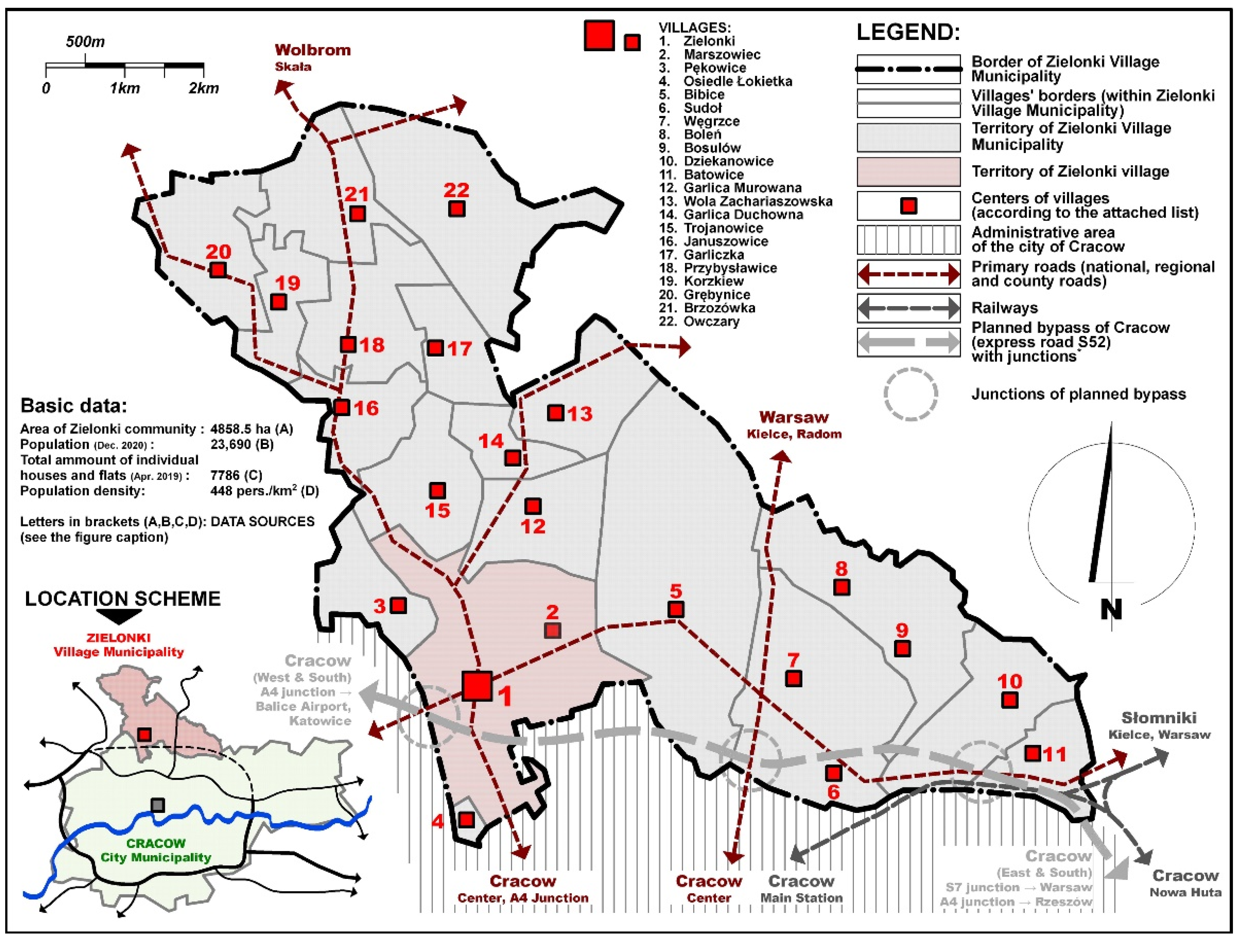
In reference to the problems outlined in the introduction, this study investigated essential functio-spatial and service structures in a selected suburban area of Krakow, Poland, in terms of the interrelations within the functio-spatial structure and their accessibility. The study focused on the Zielonki municipality, which is located within the limits of the metropolitan area of Krakow, as an area that is typical in terms of the character and intensity of urbanization processes that currently take place within the impact zones of large cities in Poland (
Figure 1).
This study was based on original field research, a review of the literature, and a detailed analysis of available planning documents, development strategies, and statistical data. GIS tools, cartographic materials, and satellite images from various years, including recent ones, were also used.
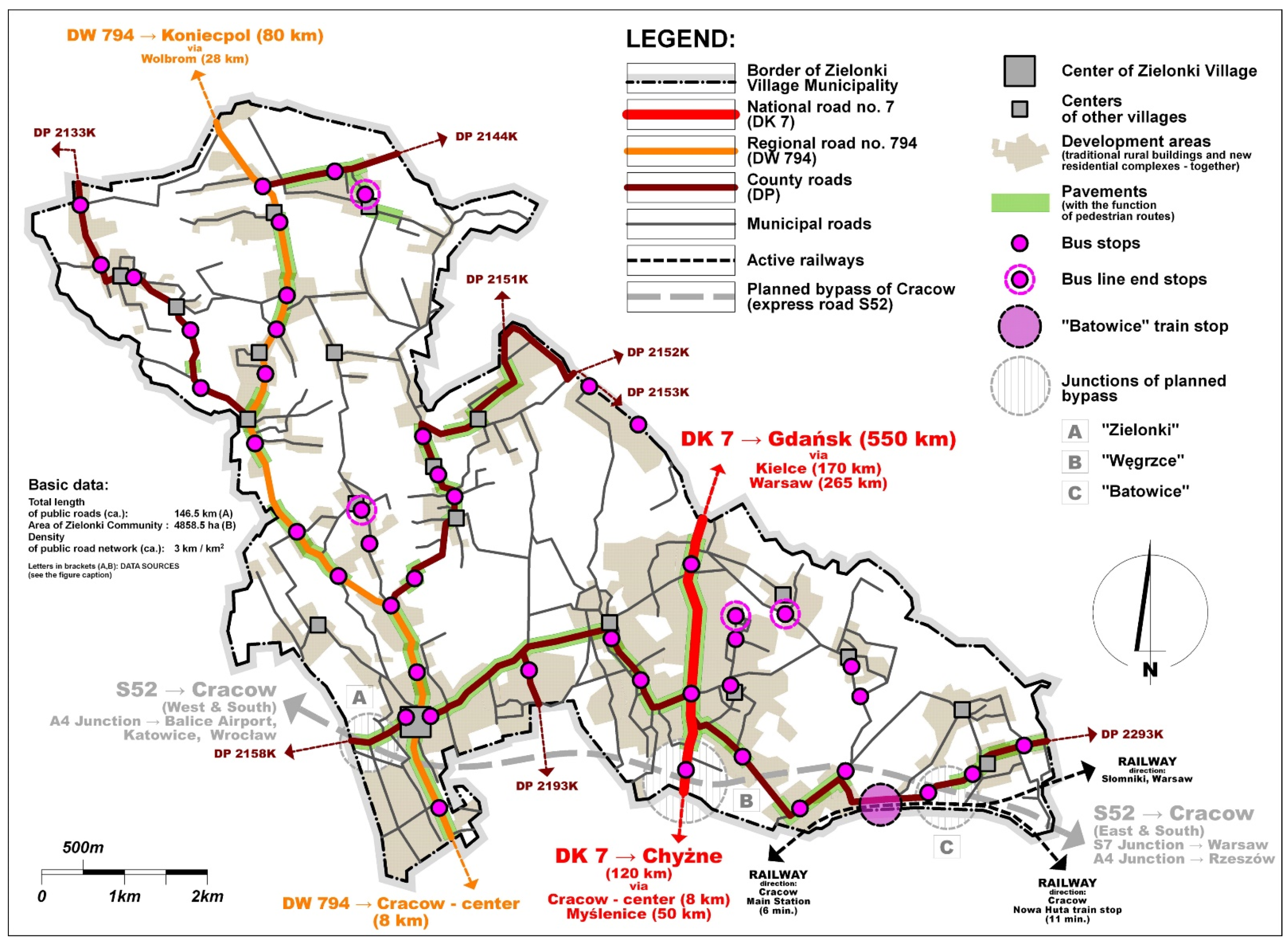
Over the course of the investigation, a range of analyses was performed, which allowed for a qualitative and quantitative assessment of the phenomena and processes present in the area under study. The municipality’s functio-spatial structure was documented with an emphasis on historical and contemporary settlement areas. Furthermore, the transport layout of the municipality was identified, showing the road hierarchy and public transport system along with the placement of bus and rail stops (
Figure 2). Afterwards, using GIS data, primary traffic attractors were identified, which predominantly included complexes and significant buildings with public, commercial, cultural, educational, sports, leisure, administrative, and religious uses, as well as all public transport stops. The distribution of the traffic generators identified has been presented against the municipality’s transport network (
Figure 3).
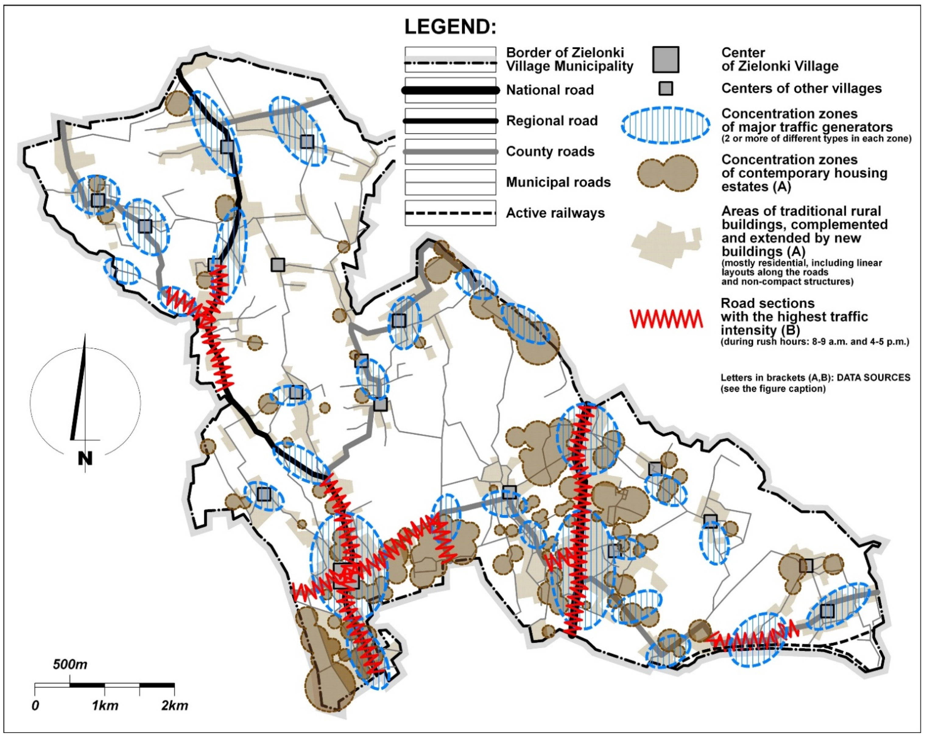
Over the course of the investigation, an analysis of relations between essential functio-spatial structure elements was performed. These elements included service concentration sites and areas with contemporary housing developments that manifested as densely developed complexes of detached, semi-detached, and single-family row houses. The traffic concentration zone in each case included at least two traffic generators of varying uses, located in close proximity to each other. The modeling method that was used allowed for the presentation of spatial relations between individual traffic-generating areas—service concentration sites, public transport stops, and areas with dense single-family housing. These relations have been presented against the road transport layout in the Zielonki municipality, with the highest-traffic elements of this layout highlighted (
Figure 4).
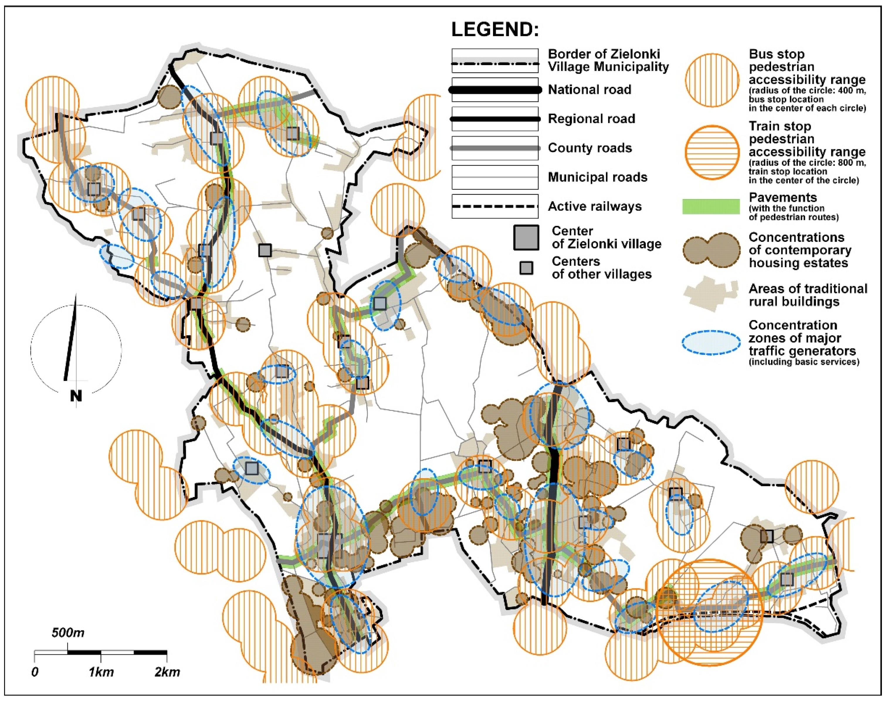
Based on data concerning the distribution of areas with dense housing developments, service concentration sites, and the placement of public transport stops, an accessibility analysis was performed for these elements of the municipality’s functio-spatial structure. The criterion of accessibility was assumed as the distance from a public transport stop that measured no more than 400 m for a bus stop [
24,
25] and 800 m for an existing commuter rail stop, measured in a straight line (
Figure 5).
Olszewski [
24] reported that the typical speed of travelling on foot at a leisurely pace is between 0.9 and 1.5 m/s (3.24 and 5.4 km/h). Daamen [
26] found the average pedestrian’s movement speed to be 1.34 (4.82 km/h). Olszewski also cited Polish guidelines [
27], where a typical movement speed of 1.1–1.4 m/s (3.96–5.04 km/h) was recommended for design purposes.
3. Results
The functio-spatial structure of the Zielonki municipality is based on a road transport network dominated by municipal roads, which are of relatively low rank. Public transport is operated almost exclusively by city buses along the main communication routes. Rail transport was observed to have marginal significance, mostly due to the peripheral location of the municipality’s only rail stop. In general, the municipality has very poor bicycle and pedestrian infrastructure—it does not have a dedicated system of bicycle paths that would play a circulatory role, and pavements that act as footpaths are only present along the national road and along sections of the voivodeship road and county roads. These observations have been presented in and are confirmed by data shown in
Table 1.
The Zielonki municipality, as an area located in the direct impact zone of Krakow, was found to be undergoing intense urbanization processes—which were visible both in the spatial and social sphere. Statistical data show a visible rise in the municipality’s population (
Table 2)—by almost 9% in the years 2016–2020 (from 21,744 to 23,690), which is aligned with tendencies present in similar Polish municipalities.
The rise in the municipality’s population is obviously tied with the development of housing, which almost exclusively takes on the form of individual single-family residential buildings, mostly either detached or semi-detached, with row buildings being rare. The development pressure in the Zielonki municipality carries over to the number of building permits issued, which was continuously high throughout the 2016–2020 period. During this time, building permits for single-family houses comprised almost half of all permits issued in the municipality’s territory, and amounted to almost 75% of all permits in 2020 alone (
Table 3).
The process of continued settlement in the community under analysis results not only in an increase in land developed as housing, but also in a significant rise in the number of vehicles, especially cars for private use by residents for commuting (
Table 4).
The data presented in the tables above demonstrate that the process of the Zielonki municipality’s urbanization has been dynamic and persistent over the past few years. The development of its functio-spatial structure does not carry over to a qualitative improvement, and primarily manifests itself in an increase in areas assigned for individual single-family housing. Such areas appear primarily on the edges of existing settlement structures, as independent enclaves located at a considerable distance and sometimes even isolated from major roads. The construction of new housing complexes is not accompanied by the provision of essential services, which concentrate almost solely within historical settlement layouts and along major transport arterials. The review of available maps and planning documents showed that the municipality’s essential transport layout did not change during the period of its dynamic urbanization. The main skeleton of its transport system continued to be formed by the national and voivodeship road along with several sections of county roads; none of these elements saw any significant modernization, despite high traffic intensity and periodic congestion. Furthermore, the municipality lacks pedestrian and bicycle infrastructure, and public transport routes predominantly overlap with major road arterials and do not reach intensely urbanized areas. The role of the railway as a means of transport between Zielonki and Krakow remained marginal.
The shape of the functio-spatial structure of the municipality observed during the investigation, as well as the processes of its transformation, have an obvious impact on the accessibility of this structure’s key elements. Model analyses demonstrated that a significant part of recently built housing estates/complexes were located outside of local service concentration zones and were located too far away from existing stops (
Figure 6). As a consequence, many new housing estates’ access to essential services and means of public transport was either partially or wholly limited, and they were not observed to be equipped with pedestrian or cycling infrastructure. This investigation showed that out of the 60 recently built housing estates that were surveyed, as many as 35, which is almost 60%, do not have good accessibility (poor or partially limited) to essential services and public transport (
Table 5)—these estates are located away from the primary services concentration zones and more than 400 m from public transport stops. Limited accessibility forces local residents to use cars as a basic means of transport, which results in the further intensification of road traffic and the worsening of transport problems (such as congestion, traffic collisions, excessive air pollution, and noise emissions). The unfavorable manner in which the transport layout was being remodeled and developed also contributed to this. Previously undeveloped areas became the site of large housing complexes, typically at a considerable distance from the existing transport layout. These are typically projects by real estate development companies, with between a dozen and several dozen houses grouped in a relatively small area. The construction and later use of such complexes forces the existing road network to branch out, which typically takes on the form of dead-end streets that extend from a superior road on both of its sides.
As a consequence, the local transport network becomes excessively extended, and its new elements provide access only to nearby housing. The local road layout was, thus, found to not contribute to improving the overall efficiency of the entire transport system and to not improve the accessibility of external areas. The graphical analysis of a fragment of the functio-spatial structure—one of the many areas of the municipality that was radically redeveloped and almost entirely assigned to housing over the past two decades—illustrates this problem (
Figure 7). An area of 8.6 ha is shown on satellite images from 2005 and 2021 further in the text. The area is located at a distance of almost 700 m eastwards from the center of the Zielonki rural community.
The comparison of the photos demonstrates that the municipality’s progressive urbanization led to a significant growth of housing developments and its accompanying extension of intra-complex transport layouts, whose range and function are confined solely to the area of the housing estate it is to serve. Over the past fifteen years, the number of residential buildings in the area (detached, semi-detached, and in a row layout) increased fourfold—from around 55 to around 210 (which corresponds to an increase in the area’s population from around 150 in 2005 to around 600 in 2021). This was accompanied by a rapid, nearly sixfold increase in the total length of internal roads, but no modernization of the main transport layout in this region followed.
When one accounts for the current dynamic of Zielonki’s urbanization, as well as that of other areas within Krakow’s direct impact zone, it can be presumed that the problems diagnosed here are long-lasting and can be expected to intensify in the future; thus, they require countermeasures.
4. Discussion
The investigation carried out in Zielonki clearly showed that urbanization processes within Krakow’s suburban zone led to a dynamic rise in homogenous single-family housing complexes, a significant portion of which is located outside of established development areas or on their outskirts and has limited access to essential services and means of public transport. The progressive growth of the municipality’s population and the accompanying rise in cars result in an intensification of typical transport problems. The municipality was also observed to have a poorly developed road transport network and to lack bicycle and pedestrian infrastructure, and it was seen to not make use of the potential offered by commuter rail. Public transport is confined to a couple of bus lines, whose stops are distributed almost solely along main roads and do not directly serve the areas under strong development pressure, i.e., which were being developed as single-family housing complexes. To the municipality’s residents, public transport can, thus, be considered an unattractive alternative. The lack of an accessible high-bandwidth means of transport leads to an increase in traffic intensity, especially along the main arteries that connect Zielonki with Krakow.
The conditions presented create specific human behaviors regarding everyday commutes between people’s places of residence (locally), work (mainly in Krakow), and service concentration zones (mostly in historical village centers and along main transport arterials). The latest comprehensive traffic study, which covered the transport behaviors of the residents of Krakow and its peripheral municipalities (including Zielonki), was prepared in 2013 [
28]. This study showed that the residents of peripheral municipalities were more likely to choose to commute by car (Krakow: 33.7%; peripheral municipalities: 36.2%), and they used public transport to a significantly lesser degree (Krakow: 36.3%; peripheral municipalities: 23.8%), reporting a greater frequency in travelling on foot (Krakow: 28.4%; peripheral municipalities: 34.3%) and by bicycle (Krakow: 1.2%; peripheral municipalities: 3.0%). Over 200 respondents were interviewed in the municipality of Zielonki, and it was observed that the most frequently chosen means of transport was the car (over 51% of travels). Only 13.4% of respondents traveled on foot, and 24% of respondents traveled by public transport. A survey study was also performed, in which local residents were asked about what could make them more inclined to switch from using the car (in their commutes to and from Krakow). The responses that were most commonly given by residents of peripheral municipalities were an increase in public transport frequency (43.6%) and the possibility to arrive at one’s destination faster by public transport (39.4%). These studies were not verified by the authors of the article, but they constitute interesting material that indicates the tendencies of the inhabitants’ communication behavior.
It appears that a change in unfavorable tendencies requires primarily an effective implementation of sustainable transport principles in the Zielonki municipality, namely, the stimulation of public transport (bus and rail) and the construction of an effective system of pedestrian and bicycle linkages with a circulatory function. Here, the experience of large European cities and their strategies and methods of action can prove helpful. For instance, effective action to limit the role of individually used cars was taken in Amsterdam [
29], -also in Bratislava and in its suburbs, which are to be included in an integrated public transport system [
30]; as well as the city of Lille, which follows transit-oriented development [
31].
The municipality of Zielonki develops and transforms in accordance with applicable planning documents. Planning tools, namely, the local spatial development plan and the spatial development conditions and directions study, were observed to fail in their respective essential tasks. The existing functio-spatial structure is scattered, disintegrated, and does not meet the criteria of sustainable development in terms of accessibility and the precepts of providing transport access to new housing areas. There is a lack of legible development models based on sustainable transport and the full integration of the functio-spatial structure with transport infrastructure elements. Many researchers advocate that it is advised for the contemporary development of urbanized structures, including suburban ones, to be based on previously developed models and precepts that account for the need to provide good accessibility to the structure’s elements.
The precepts and models listed include UrbanSim [
32], New Urbanism [
16], and even a return to the neighborhood unit [
33]. Spatial planning based on a pre-determined model of the functio-spatial structure’s development requires the involvement of various stakeholder groups in the planning process, who participate in a sort of “game for space” [
34]. Among the process’s participants, we can list property owners (developers), municipal government entities responsible for implementing plans and issuing administrative decisions, residents who take part in public consultation, real estate development companies that operate based on their business principles, and designers—urban planning, design, and transport practitioners. Each of these groups can present mutually exclusive visions of their planned actions and interests. Conflicts of this type can occur even within these groups, and the spatial planning system still lacks instruments that would facilitate compromise and the formulation of shared goals [
35]. Attempts to reduce the distance between services and housing also seem important, which favors the creation of local centers, reduces the need for travel, and helps to ensure the spatial cohesion of built-up areas [
36].
5. Conclusions
The study of the impact of transport on the transformation of the functio-spatial structure of the Zielonki municipality, in the aspect of the accessibility of selected elements of this structure, led to the formulation of some important specific and general conclusions. The specific conclusions include:
The Zielonki municipality, which is under the direct influence of Krakow as a metropolitan core city, is currently in a strong process of urbanization (suburbanization), which results in a significant increase in new housing areas, an increase in population, and the number of cars used in its area;
Transformations of the municipality’s functio-spatial structure primarily include the construction of new housing estates located outside of existing development complexes, at significant distances from existing service concentration zones, major transport arterials, and public transport stops (buses and commuter rail);
The essential road-based transport skeleton links the centers of traditional settlement layouts in the municipality’s limits, yet it does not directly serve areas of contemporary urbanization—transport layouts created within new housing estates are of a solely local (intra-estate) significance, and do not contribute to enhancing the entire transport system, leading to a worsening of existing transport problems;
The dynamic and spontaneous development of housing in the form of individual single-family houses, combined with a lack of proper pedestrian and bicycle infrastructure, does not provide proper accessibility in place of residence–place of work destinations and essential service locations;
The current state and the observed tendency in the transformation of Zielonki’s functio-spatial structure does not meet relevant criteria in terms of accessibility and transport services, especially in relation to new housing areas, which is clearly at odds with the idea of sustainable development, sustainable transport included;
Existing conditions do not facilitate the shaping of desired travel behaviors in the municipality’s residents—most continue to prefer individual cars as their default mode of everyday transport, which clearly deepens problems and transport conflicts such as traffic congestion, collisions, excessive air pollution, and noise emission, and ultimately leads to a deterioration in quality of life.
The general conclusions are:
It appears that the fundamental challenge to the contemporary development of the Zielonki municipality is the integrated and cohesive planning of its functio-spatial structure and transport system—in this respect, it may prove helpful to adopt a pre-defined development model that could aid in limiting spontaneous action in space and allow for the emergence of a logical and legible structure;
A model approach to the municipality’s planning should account for sustainability principles, which also includes transport—it is necessary to take action to strengthen the role of public transport (bus and rail) and create proper pedestrian and bicycle infrastructure while limiting the use of cars;
Spatial planning instruments—especially local spatial development plans—should denote housing areas based on reliable analyses of actual demand for this form of use, and the potential to provide actual accessibility to the major elements of the municipality’s functio-spatial structure from the housing areas outlined in the plan.
Author Contributions
Conceptualization, S.P.-O., T.B. and P.L.; methodology, S.P.-O., T.B. and P.L.; software, S.P.-O., T.B. and P.L.; validation, S.P.-O., T.B. and P.L.; formal analysis, S.P.-O., T.B. and P.L.; investigation, S.P.-O., T.B. and P.L.; resources, S.P.-O., T.B. and P.L.; data curation, S.P.-O., T.B. and P.L.; writing—original draft preparation, S.P.-O., T.B. and P.L.; writing—review and editing, S.P.-O., T.B. and P.L.; visualization, P.L.; supervision, S.P.-O. and B.T; project administration, S.P.-O. and T.B. All authors have read and agreed to the published version of the manuscript.
Funding
This research received no external funding.
Institutional Review Board Statement
Not applicable.
Informed Consent Statement
Not applicable.
Conflicts of Interest
The authors declare no conflict of interest.
References
- Martyniuk-Pęczek, J.; Martyniuk, O.; Pęczek, G. Economic Vitality of Polish Suburbs. GSTF J. Eng. Technol. 2016, 3, 39–48. [Google Scholar]
- Hlaváček, P.; Kopáček, M.; Kopáčková, L. Impact of Suburbanisation on Sustainable Development of Settlements in Suburban Spaces: Smart and New Solutions. Sustainability 2019, 11, 7182. [Google Scholar] [CrossRef] [Green Version]
- Batara Surya, B.; Salim, A.; Sahban, H.; Suriani, S.; Menne, F.; Rasyidi, E. Land Use Change, Urban Agglomeration, and Urban Sprawl: A Sustainable Development Perspective of Makassar City, Indonesia. Land 2021, 10, 556. [Google Scholar] [CrossRef]
- Stanković, M.; Gladović, P.; Popović, V.; Lukovac, V. Selection Criteria and Assessment of the Impact of Traffic Accessibility on the Development of Suburbs. Sustainability 2018, 10, 1977. [Google Scholar] [CrossRef] [Green Version]
- Hansen, W.G. How Accessibility Shapes Land Use. J. Am. Inst. Plan. 1959, 25, 73–76. [Google Scholar] [CrossRef]
- Envall, P. Accessibility planning: A chimera? Ph.D. Thesis, University of Leeds, Leeds, UK, 2007. [Google Scholar]
- Komornicki, T.; Śleszyński, P.; Rosik, P.; Pomianowski, W.; Stępniak, M.; Silka, P. Dostępność przestrzenna jako przesłanka kształtowania polskiej polityki transportowej. Biuletyn KPZK PAN 2009, 241. Available online: http://agro.icm.edu.pl/agro/element/bwmeta1.element.dl-catalog-b5b101d5-4212-4a52-b1d3-c4926fa13705 (accessed on 10 August 2021).
- Geurs, K.; Zondag, B.; de Jong, G.; de Bok, M. Accessibility appraisal of land-use/transport policy strategies: More than just adding up travel-time savings. Transp. Res. Part D Transp. Environ. 2010, 15, 382–393. [Google Scholar] [CrossRef]
- Bos, R.; Lee, S. Accessibility based planning in the Netherlands: Better, faster, together. More Oportunities with Less Mobility. In Proceedings of the 48th ISOCARP Congress, Perm, Russia, 10–13 September 2012; pp. 1–12. [Google Scholar]
- Jayasinghe, A.; Madusanka, N.B.S.; Abenayake, C.; Mahanama, P.K.S. A modeling framework: To analyze the relationship between accessibility, land use and densities in urban areas. Sustainability 2021, 13, 467. [Google Scholar] [CrossRef]
- Jayasinghe, A.; Sano, K.; Rattanaporn, K. Application for developing countries: Estimating trip attraction in urban zones based on centrality. J. Traffic Transp. Eng. 2017, 4, 464–476. [Google Scholar] [CrossRef]
- Berg, C.N.; Deichmann, U.; Liu, Y.; Selod, H. Transport policies and development. J. Dev. Stud. 2017, 53, 465–480. [Google Scholar] [CrossRef] [Green Version]
- Næss, P.; Vogel, N. Sustainable urban development and the multi-level transition perspective. Environ. Innov. Soc. Transit. 2012, 4, 36–50. [Google Scholar] [CrossRef] [Green Version]
- Bartosiewicz, B.; Pielesiak, I. Spatial patterns of travel behaviour in Poland. Travel Behav. Soc. 2019, 15, 113–122. [Google Scholar] [CrossRef]
- Dujava, D.; Kališ, R. How transport policy shapes commuting patterns: The case of the Bratislava sub-urban area. Case Stud. Transp. Policy 2021, 9, 567–577. [Google Scholar] [CrossRef]
- Stanislav, A.; Chin, J.T. Evaluating livability and perceived values of sustainable neighborhood design: New Urbanism and original urban suburbs. Sustain. Cities Soc. 2019, 47, 101517. [Google Scholar] [CrossRef]
- Nilsson, K.; Nielsen, T.S.; Aalbers, C.; Bell, S.; Boitier, B.; Chery, J.P.; Fertner, C.; Groschowski, M.; Haase, D.; Zasada, I.; et al. Strategies for sustainable urban development and urban-rural linkages. Eur. J. Spat. Dev. 2014, 25. Available online: https://hal.archives-ouvertes.fr/hal-01528698/ (accessed on 10 August 2021).
- Bolleter, J.A. Fringe benefits? A review of outer suburban development on Perth’s fringes in relation to state government goals concerning the natural environment and efficient transport connectivity. Aust. Plan. 2017, 54, 93–114. [Google Scholar] [CrossRef]
- Biolek, J.; Andráško, I.; Malý, J.; Zrůstová, P. Interrelated aspects of residential suburbanization and collective quality of life: A case study in Czech suburbs. Acta Geogr. Slov. 2017, 57–1, 65–75. [Google Scholar] [CrossRef] [Green Version]
- Persky, J. Central City and Suburban Development: Who Pays and Who Benefits? Federal Reserve Bank of Chicago: Chicago, IL, USA, 1996. [Google Scholar]
- Ambarwati, J.; Verhaeghe, R.; van Arem, B.; Pel, A.J. The influence of integrated space–transport development strategies on air pollution in urban areas. Transp. Res. Part D Transp. Environ. 2016, 44, 134–146. [Google Scholar] [CrossRef]
- Frumkin, H. Urban Sprawl and Public Health. Public Health Rep. 2002, 117, 201. [Google Scholar] [CrossRef]
- Wann-Ming, W. Constructing urban dynamic transportation planning strategies for improving quality of life and urban sustainability under emerging growth management principles. Sustain. Cities Soc. 2019, 44, 275–290. [Google Scholar]
- Olszewski, P. Walking as a mode of transport—A planning and policy perspective. Pr. Nauk. Politech. Warszawskiej. Bud. 2007, 146, 5–149. [Google Scholar]
- Gadziński, J.; Beim, M. Dostępność przestrzenna lokalnego transportu publicznego w Poznaniu. Transp. Miej. I Reg. 2009, 5, 10–16. [Google Scholar]
- Daamen, W. Modelling Passenger Flows in Public Transport Facilities. TRAIL Thesis Series. Ph.D. Thesis, Delft University, Delft, The Netherlands, 2004. [Google Scholar]
- Komar, Z.; Wolek, C. Inżynieria Ruchu Drogowego—Wybrane Zagadnienia; Wydawnictwo Politechniki Wrocławskiej: Wrocław, Poland, 1994. [Google Scholar]
- Szarata, A. Wyniki badan podróży w Krakowie—KBR 2013 The results of travel survey in Cracow—Complex Traffic Survey 2013. Transp. Miej. I Reg. 2013, 5, 4–8. [Google Scholar]
- Bertolini, L.; le Clercq, F. Urban development without more mobility by car? Lessons from Amsterdam, a multimodal urban region. Environ. Plan. 2003, 35, 575–589. [Google Scholar] [CrossRef]
- Michniak, D. Transport-related problems of Bratislava city and its suburban region. Przegląd Geogr. 2020, 92, 213–226. [Google Scholar] [CrossRef]
- Liu, L.; L’Hostis, A. Transport and Land use interaction: A French case of suburban development in the Lille Metropolitan Area (LMA). Transp. Res. Procedia 2014, 4, 120–139. [Google Scholar] [CrossRef]
- Waddel, P. UrbanSim: Modeling Urban Development for Land Use, Transportation and Environemntal Planning. J. Am. Plan. Assoc. 2002, 68, 297–314. [Google Scholar] [CrossRef]
- Friedman, B.; Gordon, S.P.; Peers, J.B. Effects of Neotraditional Neighbourhood Design on Travel Characteristics. Transp. Res. Rec. 1994, 1466, 63–70. [Google Scholar]
- Zastawnik, A. Kształtowanie Przestrzeni Z Udziałem Społeczności Lokalnych W Procesie Planowania Przestrzennego Na Wybranych Przykładach Gmin Małopolskich; Cracow University of Technology: Cracow, Poland, 2013. [Google Scholar]
- Puławska-Obiedowska, S. Modelowanie Dostępności Miejskiego Transportu Zbiorowego. Ph.D. Thesis, Faculty of Civil Engineering, Cracow, Poland, 2018. [Google Scholar]
- Zhang, W.; Lu, D.; Zhao, Y.; Luo, X.; Yin, J. Incorporating polycentric development and neighborhood life-circle planning for reducing driving in Beijing: Nonlinear and threshold analysis. Cities 2022, 121, 103488. [Google Scholar] [CrossRef]
| Publisher’s Note: MDPI stays neutral with regard to jurisdictional claims in published maps and institutional affiliations. |
© 2022 by the authors. Licensee MDPI, Basel, Switzerland. This article is an open access article distributed under the terms and conditions of the Creative Commons Attribution (CC BY) license (https://creativecommons.org/licenses/by/4.0/).


