1. Introduction: Definitions
Rewilding and ecosystem restoration are highly focused on the restoration of wildlife/biodiversity. But, as this chapter aims to demonstrate, this ought to be a collaboration between the abiotic and biotic components of nature, while landscape restoration should aim at achieving authenticity in geomorphological landforms and physical processes. However, let us start with some important definitions:
Biodiversity—The
Convention on Biological Diversity [
1] defines biological diversity as “the variability among living organisms from all sources including…terrestrial, marine and other aquatic ecosystems and the ecological complexes of which they are part; this includes diversity within species, between species, and of ecosystems”.
Geodiversity—The most recognised definition of geodiversity is from Gray [
2] (p. 12), who defines it as “the natural range (diversity) of geological (rocks, minerals, fossils), geomorphological (landforms, topography, physical processes), soil and hydrological features. It includes their assemblages, structures, systems and contributions to landscapes”. According to Boothroyd and McHenry [
3], this definition, or variations of it, was supported by 88% of relevant publications between 1993 and 2019, while Maliniemi et al. [
4] argued that there has been “too much diversity” in the use of the term and that Gray’s definition “should be used consistently when bringing geodiversity into biodiversity research” (p. 4). Geodiversity can therefore be regarded as the abiotic equivalent of biodiversity.
Geomorphology—
The International Association of Geomorphologists are involved in “the interdisciplinary and systematic study of landforms, their landscapes and the Earth surface processes that create and change them”. Viles [
5] promoted the concept of “biogeomorphology” for the two-way relationships between biological, ecological and geomorphological systems.
Nature—Many definitions of nature have been proposed, but most include both biotic and abiotic aspects of the environment. For example, the Cambridge Dictionary [
6] defines nature as “all the animals, plants, rocks, etc. in the world and all the features, forces and processes that happen or exist independently of people…”. The
Scottish Biodiversity Strategy to 2045 [
7] (p. 9) states that “Nature includes biodiversity, geodiversity and the natural elements of our landscapes and seascapes”. Similarly, Justice et al. [
8] argue that nature should encompass “both the non-living components (i.e. geodiversity) and the living components (i.e., biodiversity) of the natural world”. However, in everyday usage, the non-living components are often forgotten, and “nature” and “biodiversity” are used as synonyms, where “the rhetoric switches seamlessly between the two” [
8] (p. 6).
Natural Capital—Definitions of natural capital also include both living and non-living aspects of nature. For example, in 2013 the
World Forum on Natural Capital defined natural capital as “the world’s stock of natural resources which includes geology, soils, air, water and all living things” (see
Figure 1). Similarly, the
Royal Society of Biology defined it as “the elements of nature that directly or indirectly produce value to people, including ecosystems, species, freshwater, land, minerals, the air and oceans, as well as natural processes and functions” (accessed on 7 December 2024).
Ecosystem—This term was introduced by Tansley [
9], who was seeking an appropriate term for environments and habitats “in the widest sense”. So, he regarded an ecosystem as “the whole system…including not only the organism-complex, but also the whole complex of physical factors forming what we call the environment…”. Although some criticism of the phrase ensued [
10], the term reached general acceptance and was adopted by the
Convention on Biological Diversity in 1992 [
1] as “a dynamic complex of plant, animal and micro-organism communities and their non-living environment
interacting as a functional unit” (my emphasis). It follows, therefore, that
Ecosystem Restoration must involve the restoration of both the living and the non-living components of the environment. This is the fundamental basis of this paper, which aims to examine some aspects of how the physical world should be treated in restoring ecosystems and landscapes. The Intergovernmental Science-Policy Platform on Biodiversity and Ecosystem Services [
11] describes restoration as “any intentional activity that initiates or accelerates the recovery of an ecosystem from a degraded state”. Traditionally, the international community has often focused on the restoration of biological systems in isolation, but here I begin to stress the important role of geomorphology and geodiversity in rewilding and restoration programmes.
Rewilding—There has been much recent discussion of the meaning of rewilding [
12]. Carver et al. [
13], on the basis of a literature review, a survey of rewilding pioneers, and the views of participants in workshops, defined rewilding as “the process of rebuilding, following major human disturbance, a natural ecosystem by restoring natural processes…with biota that would have been present had the disturbance not occurred” (p. 1888). They propose 10 ‘rewilding principles’, but there is only one mention of abiotic nature, along with a few references to climate change and its impacts on physical processes. Rewilding often includes the reintroduction of species previously extinct in the areas, such as wolves in Yellowstone National Park or beavers and otters in the rivers of the UK. So, again, biotic nature is often the main focus of rewilding.
Nature based Solutions (NbS) are similar, though there is more emphasis on climate change, natural hazards, and the creation of long-term resilient landscapes.
2. Geodiversity/Biodiversity Linkages: How Ecosystems Work
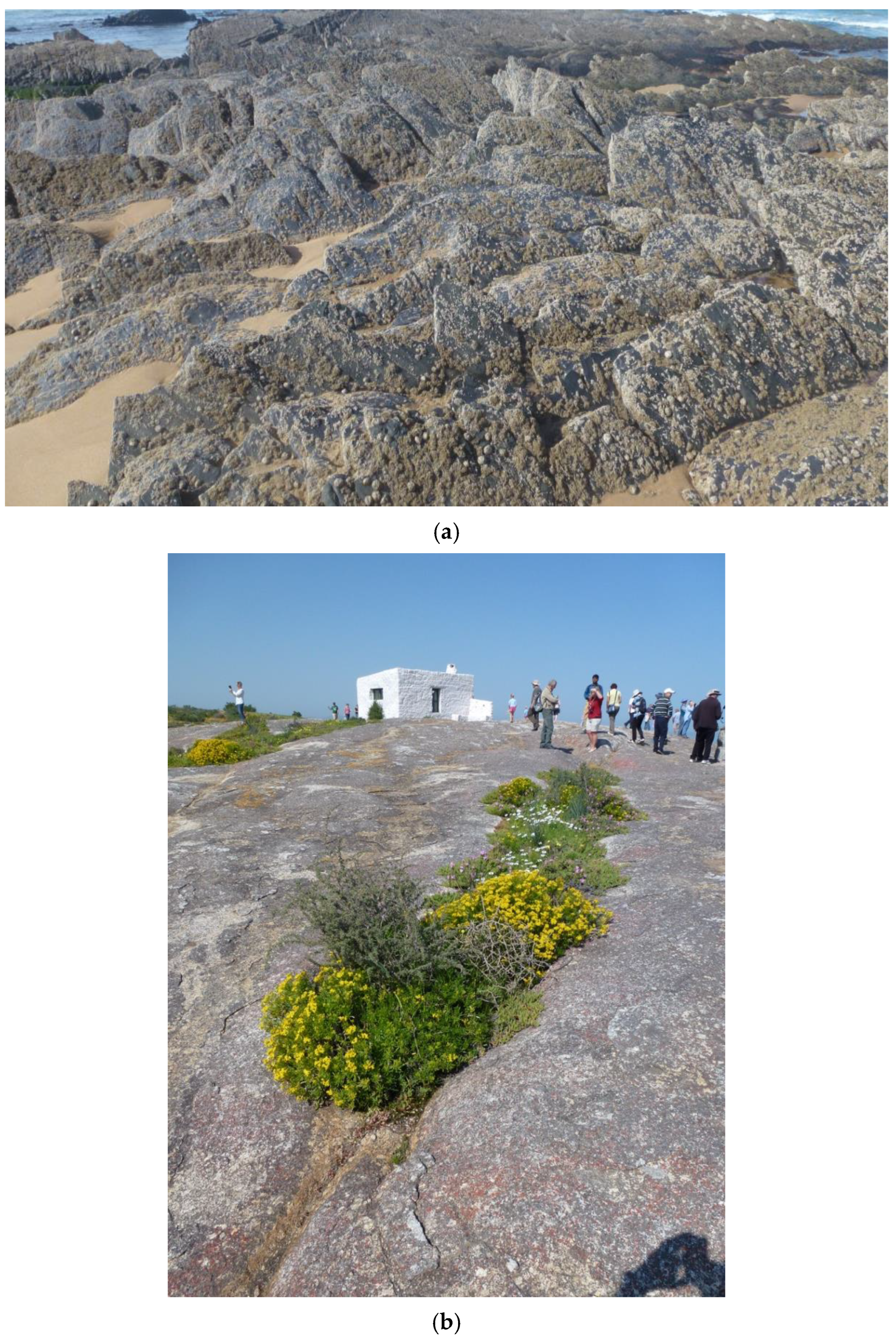
Before we look at relevant examples of ecosystem restoration, let us try and examine how ecosystems function in terms of linkages between the living and non-living world. First, the physical landscape provides a platform on and in which plants can grow and animals can roam or establish themselves (see
Figure 2a).
Secondly, while many plants can grow in cracks in rock outcrops (see
Figure 2b), a more general situation is where vegetation colonises soil. Jenny [
14] remains the key reference for understanding the crucial factors that determine soil formation and development. In this, soil properties (
s) are a function of five main factors—regional climate (
cl), organic inputs (
o), relief (
r), parent material (
p) and time (
t):
Of particular importance to the current discussion is the parent material, since soil develops through the physical, chemical or biological weathering of the underlying rocks or unconsolidated sediments. Now, rocks and sediments are composed of minerals whose chemical composition is released or altered during these weathering and soil-forming processes. The most common minerals, making up over 90% of the Earth’s crust, are silicate minerals, such as quartz, feldspars, micas, amphiboles, pyroxenes and clay minerals. These and other minerals commonly contain elements (such as calcium, phosphorus, potassium, sodium, magnesium, iron, copper, selenium and zinc) that are essential for plant, animal and, indeed, human health. The processes are complex, but these elements translocate into soils during the weathering of rocks and sediments, are absorbed by plants, and then animals and thereafter become human foodstuffs. Therefore, without doubt, there is a definite link between geological minerals/rocks and the healthy growth of all living things. Nutrient cycling from rocks and sediments into soils and onwards into the living world demonstrates a fundamental abiotic/biotic basis of ecosystems, as defined by Tansley [
9] and the
Convention on Biological Diversity [
1]. It might be argued that, in agricultural areas, many of the nutrients are derived from the addition of fertilisers rather than directly from natural sources. This is undoubtedly correct, but we then need to ask where these fertilisers come from? And the answer, of course, is often by mining lithological sources, e.g., phosphates and potash. It follows from this discussion that all life depends on the physical Earth.
Thirdly, one of Jenny’s [
14] other five key soil-forming factors is relief, which he described (p. 89) as “not receiving the attention it deserved”. In particular, he draws attention to the influence of topography on the moisture content of soil, with higher areas being relatively dry compared to topographic depressions. Also, flatter areas have thicker soil coverage than slopes due to downslope creep. Variations in soil leaching and pH are also affected by topography and these effects can influence the biodiversity that is present.
Fourthly, in terms of the important issue of climate change, much carbon storage takes place in mixed abiotic/biotic environments, including estuarine sediments, saltmarshes, Holocene peat deposits and many soils. These need to be conserved in situ or restored in order to retain or improve their carbon sequestration capacity [
15].
And finally, there are physical linkages between geodiversity and biodiversity, often described as ‘habitat provision’. These habitats may include caves, sand dunes, arctic and alpine environments, limestone pavements, intertidal zones, etc. [
16], so that “Geodiversity underpins every ecosystem and is therefore vital to biodiversity” [
17]. Some specific, recent case studies of these links, which increasingly involve international, interdisciplinary groups, took place [
18,
19] in Israel, [
20,
21] in Finland, and [
22,
23] and [
24] in the UK. Although there are exceptions, most research reveals strong relationships, in which high biodiversity is linked to high geodiversity. This has been developed into what is known as the
Conserving Nature’s Stage (CNS) approach using a theatrical metaphor in which geodiversity is the ‘stage’ on which the plants and animals ‘perform’. An important conclusion of this approach is that conserving geodiversity could be part of conserving biodiversity, especially in times of rapid climatic and environmental change, since the conserved physical habitats provide the niches into which species can migrate (see [
24] and a special section of the journal
Conservation Biology [
25]).
Thus, from the above discussion, we can see that the health of biotic systems depends largely on the properties of abiotic components. By pursuing an integrated approach to biotic and abiotic management and protection, stronger, more resilient ecosystems can be achieved, and all facets of nature can fully function and thrive [
8]. The physical and chemical linkages between geodiversity and biodiversity are very strong and unbreakable. Any efforts at rewilding and ecosystem restoration must take into account these close relationships and the way in which ecosystems operate in natural landscapes.
3. Geoscience, Rewilding and Ecosystem/Landscape Restoration
I have stressed that ecosystem restoration must take into account the abiotic basis of naturally functioning ecosystems. This section will provide examples of how that can be achieved. Successful ecosystem restoration can bring benefits for both biodiversity and geodiversity. Thus, Cienciala [
26], in a detailed examination of the relevance of physical landscape processes for conservation science and practice, concluded that “…geomorphic processes are an integral part of ecosystem dynamics at time scales relevant for conservation” and “even small-scale and subtle landscape changes can have a meaningful impact on ecological processes (and vice versa)” (p. 1).
We are currently approximately half-way through the UN Decade on Ecosystem Restoration (DER), running from 2021 to 2030. Included in the aims are restoring 350 million hectares of land, protecting or growing 1 trillion trees, expanding mangroves by 20% and sustainably managing 30 million km
2 of oceans. These aims are being delivered through thousands of individual projects across the globe, many of which are described on the UN DER website (
https://hub.decadeonrestoration.org, accessed on 7 December 2024). Priority schemes for ecosystem restoration [
27] include 10 selected by the UN, including restoring the health of the Ganges, India’s holy river, by cutting pollution, reforesting parts of the river catchment area, and promoting sustainable farming practices and building nature in Indonesia by creating conditions for mangroves to rebound naturally, using fences to trap coastal sediment over 200 ha area. Apart from these two examples, most of the paper is restricted to examples from Europe and North America as, in the rest of the world, rewilding has so far focused mainly on reintroductions of native species and has not included geoscience aspects as much.
The following are examples of restoration in different settings and, as they demonstrate, the rewilding of ecosystems and landscapes can be tackled at scales ranging from individual river reaches to entire drainage basins and sub-continental areas of thousands of square kilometres.
4. Mines and Quarries
If pits or quarries are below the water table, they may be quickly colonised by wildlife and/or water sports enthusiasts. If they are above the local water table, alternative approaches to restoring them in a geomorphologically authentic manner can be used. For example, around Aachen and Cologne in Germany, lignite seams between 10 and 100 m thick have been quarried since the 18th century in open pits up to 300 m deep. The pits cover an area of about 240 km
2. Much of this has been restored by waste infilling and rehabilitation to forestry, agriculture, horticulture, recreational or industrial land uses. However, in the recently quarried areas south of Cologne, the overburden is very carefully used to provide different soil types and different land uses. For example, thick mixtures of gravels, sand and loess were used on slopes where forestry was planned, but loess and loess loam were spread on flatter ground, meaning that extensive areas of land have been returned to agriculture [
28].
An excellent example of restoring landscapes in a geomorphologically authentic manner is described by Erikstad and colleagues [
29]. This involved the restoration of the Svea coal mines in Svalbard, the Arctic island group, to the north of mainland Norway. Coal mining in Svea lasted for a century, from 1917 to 2016, and covered a 20 km stretch of the coastline, including the mines themselves, housing, an airstrip, the port, the road system, storage areas, workshops and production areas. The road access to the mines included crossing the Marthabreen Glacier. The decision to close the mines was influenced by low coal prices and the move away from fossil fuels because of their climate impact. The
Svalbard Environmental Act (2001) states that “If an activity is closed down or discontinued, the head of the activity shall…at his own expense remove from the area all surface installations, all, waste and other remains that are not protected structures and sites…The area shall as far as possible be restored to its original condition” (cited in [
29]). This last phrase proved to be problematic because it was regarded as referring to a return to a previous static state without consideration of the highly dynamic nature of the arctic landscape and how it might have changed over the century of operation. The dilemma of what the final outcome of a restoration scheme should be and whether it is possible or appropriate to return to the original condition is extremely poignant. In this case, the project focused on reinstating the ongoing natural, glacial, periglacial, slope, fluvial and coastal geomorphological processes.
All human structures older than 1946 are protected in law and so any buildings related to the early mining history were to be retained. The state-owned mining company worked closely with the
Norwegian Institute for Nature Research (NINA) to ensure that everyone involved in the restoration project, including machine operators, participated in on-site training courses and understood the details of the landscaping operations. This included the large-scale redistribution of stone, gravel and sand, followed by surface treatment aiming to promote vegetation establishment. The main form of the restoration was based on historical maps and terrain information, taking into account likely geomorphological changes. Erikstad et al. [
29] present details of how the glacier, slopes, glacial forelands, river and avalanche fans, and tundra were treated in the restoration, with the aim of restoring the area to “near-natural conditions”, involving an inter-disciplinary approach but with the emphasis on establishing geomorphological authenticity and dynamism.
Another example of attempting authentic landscape restoration comes from Derbyshire in England, where there are several abandoned limestone quarries. Gunn and colleagues [
30,
31] described restoration blasting and appropriate seeding in quarries to replicate the form of local dry valleys (dales). Given time, this would probably develop in the same way, but the methods described allow the processes to be accelerated so that the appearance of a mature and attractive dale landscape can be developed very quickly and included the creation of rock buttresses, rock headwalls, scree slopes and debris flows.
There are many examples of quarry and mining areas where the restoration requirements by consenting authorities have focused on tree planting alone. The above examples illustrate that geomorphology and the selection of appropriate parent materials ought to be involved wherever appropriate.
5. Rivers
The human impact on rivers has been extensive and has involved both engineering within the channel and floodplain and changes in the wider catchment area. For example, deforestation within a drainage basin may increase overland flow and hence the potential erosion and sediment transfer to the river channel.
Rivers have been channelised, embanked, dammed, diverted, culverted, dredged and isolated from their floodplains. It is estimated that 98% of Danish streams and 96% of those in lowland England have been modified in some way [
32,
33]. Fortunately, the last 50 years have seen many attempts to reverse this process and river restoration is now commonly used in many countries.
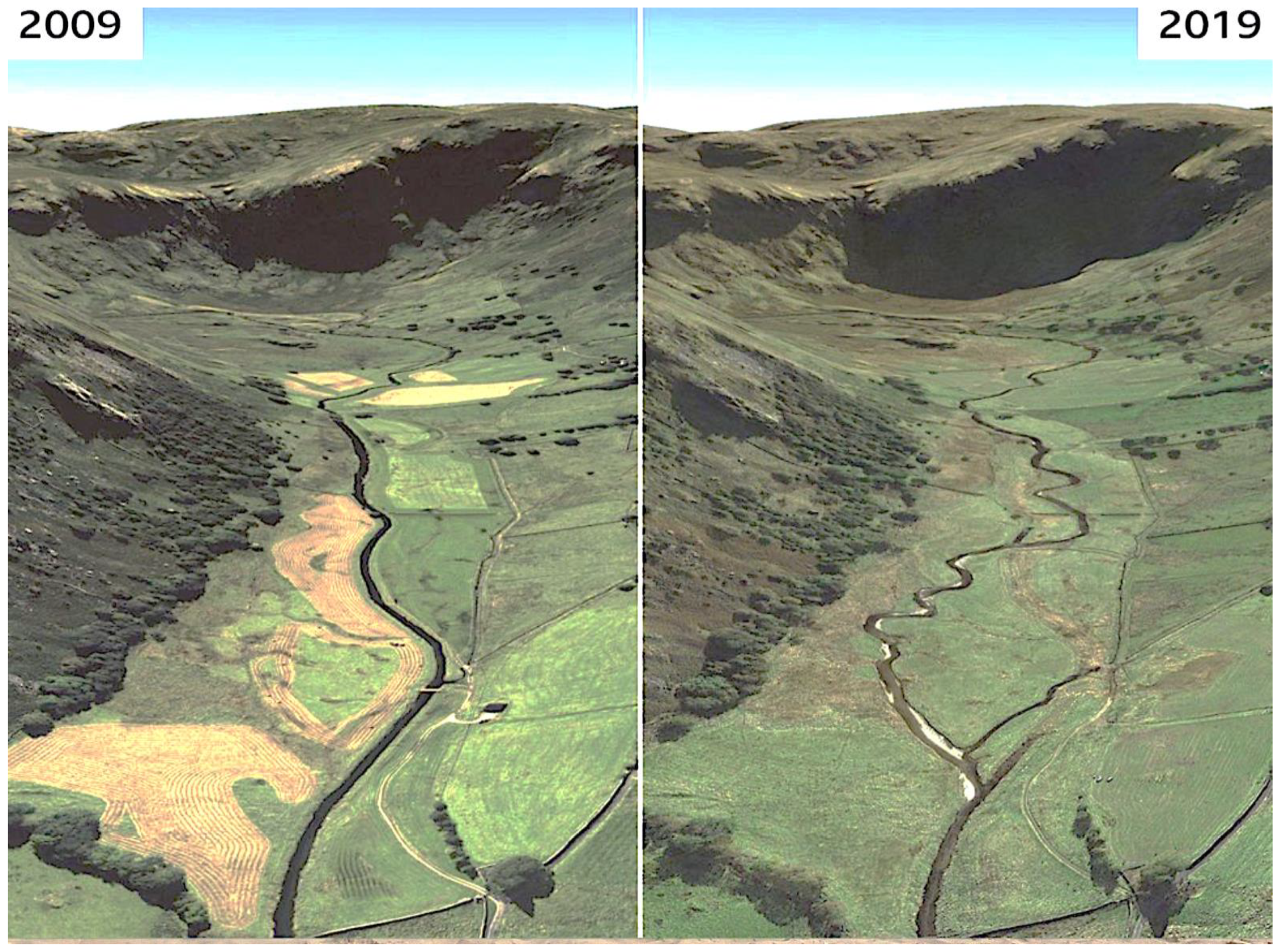
Figure 3 shows an example of a river restoration scheme in England. The scheme remeandered the straightened river, thus leading to lower stream velocities and the deposition of gravels within the river channel. The importance of this is that it allows fish to spawn within these gravels. Therefore, this is an example of a river restoration scheme bringing both geodiversity benefits (a more naturally evolving river) and biodiversity ones (encouraging fish spawning).
At a much larger scale, the river restoration of the Kissemmee River in Florida, USA is perhaps the most ambitious example of such projects in the world. Prior to 1962, the river meandered over its floodplain for 166 km. The floodplain was a rich wetland ecosystem supporting over 300 wildlife species, including resident and overwintering waterfowl and wading birds. “The diversity and persistence of these biological resources were linked to dynamic river and floodplain habitat characteristics provided by basin hydrology and channel geomorphology” [
34] (p. 369). However, between 1962 and 1971, the river was totally channelised to provide drained farmland for the expanding agricultural economy of central Florida. The major feature of the scheme was a 9m deep rectilinear canal cut through the floodplain and divided into five level reaches by water-control dams and separated from the floodplain by levees. This resulted in a dramatic loss of habitat and wildlife. The impact soon led to calls from the local community and environmental groups for the river to be restored and a number of feasibility projects were carried out in the 1980s and 1990s. Lessons learnt from this work led to a state/federal partnership plan for dechannelisation, and this was carried out between 1999 and 2020 at a cost of USD 400 million at 1997 prices [
34]. Many species of ducks and wading birds—including the ring-necked duck, American avocet and black-necked stilt—are now present. These species were not present during pre-construction surveys.
The Kissemmee scheme is an extreme example of what can be achieved, but the River Restoration Centre has been collecting many examples of river restoration for the last 30 years (RRC;
https://www.therrc.co.uk/assets/general/Training/esmee/what_is_river_restoration_final.pdf, accessed on 13 January 2026). Some key principles are, wherever possible, to take a whole catchment approach, and to re-establish natural physical processes, allowing rivers to function and evolve as natural, dynamic rivers would, albeit often influenced by human interference in the catchment and channel processes [
26]. Richards et al. [
35] (pp. 575–576) concluded that there is a need for “closer collaboration between aquatic and terrestrial biologists and fluvial geomorphologists, to inform the choice of restoration aims, policy and practice, and to ensure that the research and data needs are met for restoration of the appropriate dynamics at the appropriate scale”.
6. Lakes and Ponds
The Lake Tahoe Basin straddles the border between California and Nevada. Beginning in the 1850s, logging and mining initially stimulated development, eventually leading to urbanisation. In turn, this led to a deterioration in water quality, deforestation, heightened fire risk and declines in aquatic and terrestrial wildlife [
35]. Restoration of the Tahoe catchment area began in 1969 through a Bi-State Compact between California and Nevada and the creation of the
Tahoe Regional Planning Agency (TRPA). This initially created a Regional Plan as a framework for restoration through an Environmental Improvement Program focusing on improving water quality, decreasing invasive species, maintaining populations and habitats for sensitive and listed species, and reducing wildfire risks in the surrounding forests. The projects were mainly funded by the federal government and local stakeholders and, by 2013, achievements included 20,000 ha of treated or restored land and 6000 ha of restored wildlife habitat. Ongoing problems include water pollution, invasive species and climate change [
36].
Small ponds can be formed in various ways. Some are formed naturally as kettle holes, pingos or through ground subsidence due to chalk solution. Others may be bomb craters or excavation pits, but it is often difficult to ascertain the origin of individual ponds. Many have disappeared in recent years through drying out or infilling to make farming easier. The Essex Lost Ponds Project in England has identified over 17,000 ponds in the County, 10,400 of which have disappeared. The project offers farmers and landowners a free survey to identify lost ponds on their land and obtain the funding to restore them, often from housing developers who are now required to fund biodiversity projects, often offsite. Ponds that have dried out or become shaded, once restored, are filled with rare aquatic plants, dragonflies and great crested newts, while providing food and water for birds and bats [
37] (p. 31).
A similar scheme in the Brecks area of Norfolk, England, is excavating infilled pingo ponds. Pingos are periglacial features formed during cold periods of the Quaternary. They form, for example, where spring water rises to the surface and freezes there, often resulting in a considerable thickness of ice over time. When the ice melts, a hollow forms, frequently resulting in a pond. Over time, these ponds are infilled by Holocene plant growth, leaves, etc., or by farmers dumping material in them. Excavating the ponds brings both geodiversity benefits, in revealing the pingo forms, and biodiversity benefits, as dormant seeds preserved in the sediment layers germinate, bringing back over 90 wetland plants, including the internationally significant fen pondweed and lesser bearded stonewort.
7. Coastlines
Like rivers, coastlines have been subject to hard engineering methods, in this case to prevent coastal erosion. These are now seen as unsustainable methods except in urban areas where the expense can be justified, because sea walls are expensive to install and maintain. Even with regular maintenance, a sea wall will have only a limited life before a replacement is necessary. Also, importantly, the construction of sea walls, groynes, etc., starves the coastline down drift of sediment and may accelerate coastal erosion there. In other words, human intervention is preventing the operation of natural coastal processes. In addition, the construction of coastal defences can obscure important geological exposures, for example, on the Jurassic Coast World Heritage Site, England [
38], and are not aesthetically pleasing additions to coastlines.
The alternative approach is what is often described as ‘soft engineering’, which involves understanding local coastal processes and using this understanding to achieve appropriate, nature-based, coastal management solutions. These will often involve the removal of hard defences, the use of beaches, storm ridges or sand dunes, together with beach replenishment using offshore sediment sources, and dune stabilisation. The aim is that, wherever suitable, shorelines should be restored so that they are left to evolve naturally with minimal human intervention [
39].
Many of the coastal marshlands fringing the estuaries of south-east England have been enclosed by embankments and drained over the past two centuries to provide flood defence and additional grazing or arable land. This has resulted in ‘coastal squeeze’, which occurs when rising relative sea-levels raise the low-water mark while the highwater mark is held in place by an embankment. The width of the intertidal zone is therefore reduced, with significant loss of saltmarsh geodiversity and biodiversity [
40], while the embankment is open to wave attack with resultant need for expensive maintenance. As a result, at some sites, sections of embankments have been removed, allowing the sea to flood low-lying agricultural farmland for the first time in 150 years. Subsequent studies have shown that these managed coastal realignment methods have the potential to alleviate some of the problems and costs of rising sea-levels and produce benefits for geodiversity, biodiversity and ecosystem restoration.
Also in England, during coal mining close to the coast of County Durham, at least 100 million tonnes of colliery waste was dumped over the coastal cliffs and pipelines pumped black liquid sludge into the sea. Following the closure of the last mines in the 1990s, the Turning the Tide project was implemented to restore the coastline by removing the waste from the cliffs and beaches and restoring their profiles and materials while the pithead areas were restored to grassland.
8. Other Land Restoration Projects
Community efforts at rewilding and ecosystem restoration are increasingly important, with a successful example being
Landcare in Australia. This movement of over 3000 individuals and groups across the country has also spawned more specialist ones, including
Coastcare and
Rivercare. These all share a vision to restore, enhance and protect the natural environment through land management and restoration. The project originated in Victoria in 1986, with farmers, landowners and conservationists coming together to respond to impacts of soil erosion and coastal salinity. Eberhard and Houshold [
41] describe community efforts to restore degraded karstic features in the Mole Creek karst area of Tasmania. These included removing sediment and rubbish from cave floors and entrances and cleaning sediment from delicate calcite formations.
A number of drained, upland peat bogs in Canada, Ireland and England have been restored by blocking channels and ditches in order to raise water levels and restore the bogs to more natural conditions, preventing the drying out of upland bogs and thus contributing to carbon storage. However, Mills and Rushton [
42] describe the need to assess the stability of the peat in order to avoid peat landslides. The
National Peatland Action Programme (NPAP) is a Welsh Government-funded project set up in 2020 as a key part of the Welsh Government’s ambition to address the nature and climate emergencies. By the end of 2024, some 3000 ha of peatland had been restored and the long-term aim is to triple this figure by 2031.
Koster [
43] describes projects to restore active drift sand areas in the Netherlands that have been stabilised by vegetation over the last 200 years. The project involves the removal of vegetation to allow active sand drifting to resume. This example demonstrates the need to understand the importance of the active geomorphological processes before undertaking stabilisation projects.