


Abstract
The anthropogenic transformation of modern European cities over the past centuries has been characterized by a gradual transition from a natural defensive landscape to a dense modern urban structure. This study aims to reconstruct the historical urban landscape of Sumy (Ukraine) by integrating archival cartographic materials into a digital three-dimensional model to support heritage preservation and post-war urban planning. The proposed methodology combines retrospective source analysis, comparative cartographic assessment, and GIS-based georeferencing. These approaches are used to evaluate the accuracy, scale, and reliability of historical maps. The study analyzed 18 archival maps of the city of Sumy covering the period from the 1670s to 2025. A comparative assessment enabled the selection of 4 representative cartographic sources for reconstructing the historical urban landscape. A GIS-based methodology for georeferencing archival maps was developed and validated in QGIS v.3.44.11. It used the Google Hybrid basemap in the WGS 84/Pseudo-Mercator coordinate reference system (CRS) with identifier EPSG:3857. The methodology employed a first-order affine transformation, a cubic resampling kernel (4 × 4), and 15 stable ground control points (GCPs). This ensured spatial compatibility between historical cartographic materials, contemporary geospatial datasets, and topographic-geodetic reference frameworks. The proposed approach achieved an RMS georeferencing error of 2–9 m, depending on the historical period, the accuracy, and the scale of the original cartographic sources. Furthermore, the methodology enabled the identification of three classes of anthropogenic landscape transformation (minimal, moderate, and critical). As a result, it provided a comprehensive spatio-temporal representation of the historical evolution of the urban landscape. The resulting 3D model provides a reliable geospatial framework for documenting the historical morphology of Sumy and supports future interdisciplinary studies in heritage conservation, urban planning, and post-war reconstruction. The proposed methodology can also be applied to other historical cities where archival cartographic materials constitute the primary source for reconstructing long-term landscape evolution.
1. Introduction
In today’s globalized, chaotic context, modern European cities are losing their unique identities [1]. For the Ukrainian city of Sumy, this problem is particularly relevant, as the city was founded as a Cossack fortress, whose architecture historically depended on natural slopes and rivers [2].
Unlike large historical centers of Ukraine, such as Kyiv, Kharkiv, or Lviv, which have significant systematic research on digitalization, GIS mapping, and 3D modeling of the historical environment, as well as on its transformation [3,4], Sumy city remains critically understudied in this context. Therefore, the work should fill the gap in the digital reconstruction and preservation of the architectural development of Left-Bank Ukraine, creating a digital base for the city of Sumy that did not previously exist. Previous works on Sumy were mainly limited to local historical and architectural methods [5,6] and the geo-ecological potential of the landscape [7,8], without involving modern landscape analysis. That is why Sumy was chosen as an example of a city where the natural landscape served as the foundation of defense but was later obscured by urbanization, requiring digital restoration. Moreover, a multi-layer analysis and the development of a basic 3D model of the historical landscape of Sumy city were not previously studied, and this will serve as a basis for further research into the historical transformations of urban space.
The historical and morphological value of the central part of Sumy is confirmed by current urban planning documentation, particularly the approved Historical and Architectural Reference Plan for Sumy city, Ukraine.
Sumy city, Ukraine, was also selected as the research object within the project “Scientific Foundations of the Virtual Reconstruction of Destroyed Cultural Heritage Objects for the Recovery Strategy in Ukraine,” commissioned by the Ministry of Education and Science of Ukraine. This choice is due to the high relevance of studying the features of the city’s historical formation and spatial transformation, particularly its unique natural and historical landscape. The study of these processes is critically important for developing a scientifically sound strategy for recording and further research of the urban environment and preserving its historical and cultural identity.
Meanwhile, permanent massive Russian missile attacks in 2022–2026 led to the destruction of the city’s original landscape, making it impossible to reconstruct the architectural and cultural heritage objects and spatial identity quickly. Notably, in 2025–2026, Sumy was struck by Russian UAVs and missiles more than 700 times, resulting in damage to over 450 urban infrastructure facilities, including numerous cultural heritage sites, such as the Sukhanov-Sumovsky Manor (currently housing the Institute of Applied Physics of the National Academy of Sciences of Ukraine), the former Sumy District Court building (now part of Sumy State University) [6], the Croisie sculptures, libraries, churches, and other historic objects. In particular, the Sumy Regional Universal Scientific Library, a cultural heritage monument designated as a protected site under the Hague Convention on the Protection of Cultural Property in the Event of Armed Conflict, was damaged in 2026. Moreover, in 2025–2026, the Resurrection Church and Transfiguration Cathedral in Sumy, as protected cultural heritage sites on UNESCO’s International List of Cultural Properties under Enhanced Protection (2 of 3 objects in Sumy city), were also damaged. These facts highlight the need for digital documentation and virtual reconstruction of heritage sites threatened by armed conflict. These local destructions also reflect a nationwide pattern: as of 1 July 2026, UNESCO had verified damage to 540 cultural sites across Ukraine, comprising 155 religious sites, 281 buildings of historical and/or artistic interest, 43 museums, 33 monuments, 22 libraries, 5 archaeological sites, and 1 archive [9].
Under such conditions, the development of a digital 3D model based on retrospective landscape analysis is transformed from a theoretical scientific problem into a strategic tool for fixing and preserving national identity.
Thus, the research is a timely response to society’s need to preserve cultural heritage through modern IT tools, transforming frozen archival maps into an actual 3D model that will support future reconstruction planning by restoring the historical landscape context in which architectural objects were originally located.
The historical center of Sumy is a relevant case study for the high intensity of anthropogenic changes, because here the historical defensive layout (e.g., the Sloboda fortress) has undergone significant transformations, i.e., the filling of ditches, leveling of terraces, meandering of the Psel and Sumka riverbeds, which enables verifying the accuracy of the reconstruction of the lost relief, as well as the contrast of the levels of transformation, since there are areas with well-preserved historical morphology and areas with critical Soviet and modern interventions. This also verifies the proposed three-level classification of landscape changes.
2. Literature Review
The importance of such research is also emphasized by the significant number of scientific publications that constitute the state of the art within the scope of the problem under study. In particular, several basic practices for digitizing historical urban landscapes worldwide are presented below.
In particular, Zhang and Kolisnyk [10] conducted a case study of the digital preservation of the urban landscape in the ancient city of Shandan, Gansu, China. The methodology included 3D modeling to create detailed digital images, as well as virtual reality for their interactive visualization. Wu et al. [11] proposed an automated deep learning framework for quantitative analysis of changes in the urban environment of Paris, France, using a series of historical maps from 1868 to 1937. Also, Tobiáš et al. [12] presented a comprehensive workflow for creating 3D models of historical landscapes from old maps and images, using Trimble SketchUp 3D CAD to visualize changes in the urban environment, for the case study of Czech chateaux and castles. General recommendations for the conservation of historic urban landscapes were formulated by Turner [13].
Many studies use 3D modeling to digitize architectural objects. In particular, Herold and Hecht [14] applied these tools to reconstruct urban history through retrospective land-use monitoring. Morlighem et al. [15] applied additional data and 3D modeling to create digital twins of architectural objects in different historical periods. A practical workflow for the 3D reconstruction of historical sites was developed by Bent et al. [16] by filtering depth maps for creating a 3D model of a Florentine church interior.
Study [17] proposes an approach to the 3D reconstruction of the Kinburn Fortress, an ancient fortification, based on the analysis of archival and cartographic data, followed by 3D modeling, visualization, and integration into a BIM environment. Ciampi et al. [18] proposed a multi-temporal 3D geomodeling approach that integrates cadastral maps, geological, and geophysical data to reconstruct the subsurface structure and evolution of the urban environment. Kaňuk et al. [19] applied a retrospective approach to analyze urban change, using a series of virtual 3D city models to identify changes in buildings, green areas, and open spaces, for the case study of Prešov, the Slovak Republic.
GIS and BIM technologies are also widely used for the digital reconstruction of historical urban landscapes. In particular, Ezz et al. [20] used 3D GIS for the sustainable management of UNESCO World Heritage sites in Saudi Arabia. This approach enabled the creation of 3D models, supporting decision-making in the preservation and management of cultural heritage. Also, Şenyurdusev and Dogru [21] applied a GIS-based approach for 3D modeling of historical sites in Turkey. As a result, a spatial database of Istanbul city wall fountains was digitized. Huang et al. [22] studied the urban transformation of Chinese water towns using a comprehensive space syntax and GIS approach. This research provided a framework for planning and heritage protection of ancient towns. Moreover, Deng et al. [23] integrated BIM, GIS, and point cloud data to model 3D street networks. As a result, digital data on roads, bridges, and tunnels was collected in accordance with the international standard CityGML 3.0.
The immersive heritage experience is reflected in the research by Zawadzki and Medyńska-Gulij [24] on the reconstruction of the landscapes of medieval architectural objects. This also enabled interactive visualization of Eastern European strongholds over time, enabling topographical analysis and immersive heritage exploration. An innovative approach to immersive geovisualization is also used by Li et al. [25], who present a six-layer framework for reconstructing historical gardens that integrates TLS, UAV, BIM, AR/VR, and AI technologies.
Ciccone et al. [26] applied LiDAR to a virtual reconstruction of the Torre di Castiglione tower in Italy. The use of the extended matrix method enabled scientifically accountable virtual reconstructions and testing of alternative interpretations for a non-excavated architectural object.
A cluster-based systematic review of mapping digital solutions for multi-scale observation of the built environment is presented in [27]. The application of machine learning (ML) to the digital characterization of cultural heritage sites is comprehensively analyzed by Zu et al. [28]. The methodology combines UAV-derived solutions with semiautomatic semantic segmentation of architectural objects, integrating multispectral and geometric attributes.
Since the reconstruction of the historical urban landscape is inherently interdisciplinary, the study’s theoretical framework draws on research directly related to urban landscapes and on related fields, including digital heritage documentation, GIS/BIM integration, 3D modeling, photogrammetry, LiDAR, and virtual reconstruction. These approaches provide a methodological basis for developing a comprehensive cartographic reconstruction workflow (Table 1).
Table 1.
Comparative analysis of methodological approaches supporting historical urban landscape reconstruction.
The proposed methodology combines the methodological contributions of these four research directions into a unified multi-layer cartographic workflow for historical urban landscape reconstruction.
Moreover, as can be seen, many existing methods focus on narrow tasks, such as the exclusive 3D reconstruction of buildings or the analysis of street networks. Simultaneously, it is assumed that multi-layer cartographic analysis will demonstrate the integration of different types of data (cadasters, topography, hydrography) into a single system. This will ensure a holistic understanding of the urban landscape through a socio-spatial perspective, encompassing not only the architectural component but also cultural practices and ecological structures. Moreover, greater flexibility is envisaged in adapting the number of layers to the availability of sources for a particular city or era. Some of the above studies also indicate a significant gap between academic concepts and their practical implementation in urban planning. In this context, the use of multi-layered analysis will facilitate the creation of models that are understandable not only to historians but also to urban planners, as they are based on cartographic principles. This approach could be more easily integrated into modern GIS systems and into further digital twins of cities.
Moreover, many 3D reconstructions lack a clear indication of how authentic a particular element is. Furthermore, in the proposed approach, each layer can have its own credibility assessment and source base. When new data becomes available (for example, new archive maps), you can update only a specific layer without having to redo the entire model. Finally, traditional methods often require expensive field research or excavation. However, the emphasis on analyzing historical maps and remote sensing enables the reconstruction of the landscape without costly, invasive interventions, which is especially important in densely built-up cities. In this case, the method scales from individual objects (e.g., architectural objects) to entire regional landscapes.
Despite recent advances in digital heritage documentation, several research gaps remain. Existing studies have primarily concentrated on the digital reconstruction and visualization of individual heritage buildings [5,6], with limited attention given to the reconstruction of historical urban landscape morphology. Furthermore, despite available studies on landscape districts and rivers [7,8], no comprehensive digital cartographic reconstruction of the historical urban landscape of Sumy has been conducted, representing a significant empirical gap. In addition, the above-mentioned literature lacks a reproducible methodological framework that systematically integrates archival cartographic sources, contemporary geodetic plans, landscape transformation classification, and 3D modeling into a unified multi-layer reconstruction workflow.
Drawing on a comparative analysis and addressing unresolved research gaps, the article aims to apply a multi-layer cartographic approach to the digital reconstruction of historical urban landscapes, integrating archival maps into a 3D spatial model.
To achieve this aim, the following objectives were formulated for the Sumy city case study:
- (1)
- To search for cartographic materials in archives and digital libraries with their subsequent digitization and systematization according to the chronological principle;
- (2)
- Alignment of archival maps into a single orientation and scale system to identify spatial changes and stable landscape elements;
- (3)
- Selection of representative sources, starting with schemes from the Cossack era and ending with a relevant modern architectural plan;
- (4)
- Analysis of anthropogenic transformation of natural landscape morphology under the influence of buildings with quantitative assessment of transformation levels;
- (5)
- Integration and refinement of the model by overlaying multiple layers and aligning them according to the city’s modern coordinates;
- (6)
- Comparative analysis of historical and current conditions to record the extent of landscape changes and preserved topographic structures;
- (7)
- Creation of a reconstructed model with the identification of key topographic relationships of the historical center of Sumy;
- (8)
- Development of a base 3D model of the original landscape as a fundamental for further visualization of historical buildings.
3. Materials and Methods
3.1. Substantiation of the Object of Study
The anthropogenic transformation of modern European cities over the past three centuries has been characterized by a gradual transition from a natural defensive landscape to a dense modern urbanized architecture. The article presents a comprehensive methodology for the retrospective analysis and 3D reconstruction of the anthropogenically altered landscape of a modern city, illustrated by the historical center of Sumy, Ukraine. The study traces the transformation of the territory from its original natural state in the Cossack era to the modern European city. In addition, changes in river coastlines, leveling of ravines, and the impact of dense development on the earth’s surface morphology are considered.
Multi-layered analysis is applied to recreate a historically accurate landscape of the city’s central area. Overlaying data from the 18th and 19th centuries with modern data from 1990–2025 enabled the reconstruction of lost natural forms and the development of a digital 3D model of the historical city center. The classification of city center territories by the degree of landscape change also facilitates identifying areas where the historical landscape has been preserved almost in its original form, as well as areas where it has been completely reshaped.
The historical center of Sumy was selected as the study area because it has undergone the most extensive anthropogenic modification over the centuries. Ravines were filled, slopes were leveled, and the courses of the Psel and Sumka rivers were altered. These transformations make the area suitable for evaluating the proposed reconstruction methodology. Therefore, the study of this zone provides a basis for clearly demonstrating the transition from minimal to critical landscape transformation.
Compared to many other cities in Ukraine, the center of Sumy has undergone significant engineering changes. Small rivers and streams were filled in or taken into collectors, and the landscape around the historical fortress was significantly leveled. This makes the problem of retrospective reconstruction particularly relevant.
3.2. Archival Search and Software
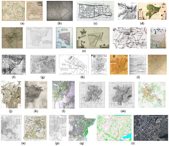
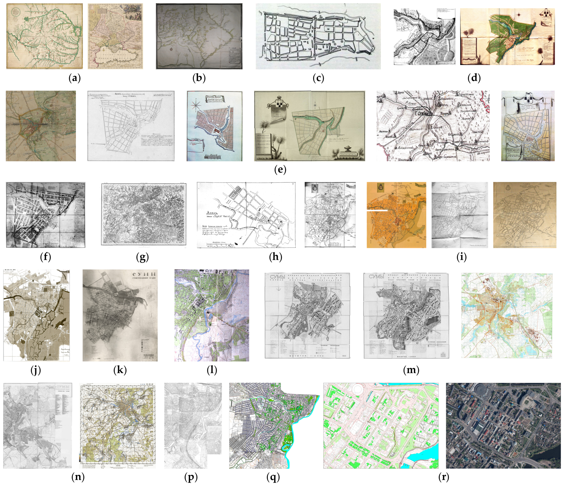
The first stage of the methodology involves creating an initial cartographic base for further landscape analysis. Working with archival maps involves the sequential search, selection, and organization of cartographic materials. Initially, sources are identified and researched in public and private archives, digital libraries, international online collections, and open Internet resources. The main focus is on maps and diagrams that contain information about the landscape, topographic structure, and historical configuration of the territory (Figure 1).
Figure 1.
A catalog compiled from maps and diagrams of Sumy city for different periods: (a) 1670–1699; (b) 1730; (c) 1750–1760; (d) 1764–1769; (e) 1783–1787; (f) 1845; (g) 1869; (h) 1895–1900; (i) 1909–1913; (j) 1922; (k) 1939; (l) 1954; (m) 1976–1978; (n) 1983–1988; (p) 1990s; (q) 2004; (r) 2025.
The collected materials, obtained at the authors’ request from the Department of Architecture and Urban Planning of the Sumy City Council (Sumy, Ukraine), have entered the stage of electronic cartographic database development, where they are being digitized at high resolution and systematically organized within a structured data catalog compliant with the FAIR (findability, accessibility, interoperability, and reusability) principles [29].
After that, the maps are arranged chronologically, which allows tracing the dynamics of landscape and development transformations and provides a basis for further comparative analysis.
The final sub-stage is the assessment of cartographic suitability and relevance. The materials are analyzed according to the criteria of accuracy, scale, preservation quality, and relevance to the research objectives. As a result, a target array of maps and diagrams is formed, which is used for subsequent research steps, such as georeferencing of objects, digital processing, and reconstruction of the landscape structure of the historical area within the research.
The second stage of the methodology is aimed at a detailed study of the collected archival maps by overlaying and comparing them. This stage involves consolidating maps and diagrams from different periods into a unified system of orientation and scale.
The archival maps were first preprocessed in Adobe Photoshop v.26.11 to improve their visual quality and prepare them for subsequent georeferencing. The software was used to edit the raster images by cropping map borders, removing scanning artifacts and other digital imperfections, balancing brightness and contrast, and enhancing the clarity of faded cartographic features while preserving the original geometric integrity of the documents.
Subsequently, the processed maps were georeferenced in QGIS v.3.44.11 (Section 3.4 and Section 4.1). It was the main tool for georeferencing and analytical comparison. Using the Georeferencer extension and the QuickMapServices plugin (in particular, the Google Hybrid layer), the archival plans were linked to the modern EPSG:3857 coordinate system using affine transformation (Polynomial 1) and cubic resampling. In the same environment, overlay analysis was performed to determine the levels of anthropogenic transformation and vectorization of hydrography, relief, and neighborhood boundaries.
Finally, SketchUp Pro v.21.1 was used to produce the final 3D reconstruction of the terrain and historical environment. DWG layers exported from engineering GIS and design programs were imported into the program’s single spatial plugin to build a digital terrain model based on the 1845 map. By interpolating contours and elevations using “Sandbox” tools, we formed a triangulation grid that recreates the original landscape context of the city.
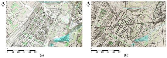
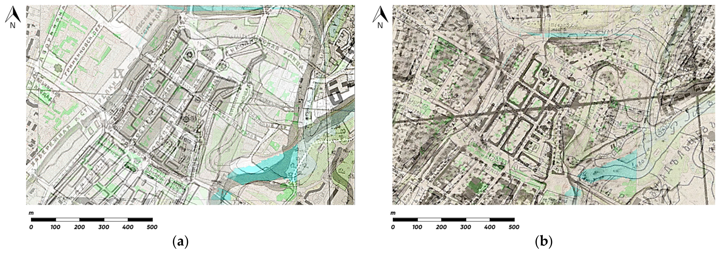
After compiling the maps, it becomes possible to identify structural similarities and differences between different periods. By overlaying plans, changes in street configurations, block perimeters, the positions of individual buildings, and landscape elements can be traced (Figure 2).
Figure 2.
Overlaying and analyzing archival maps: (a) 1750s–1760s, 1895, and 2025; (b) 1845, 1895, and 2025.
This approach enables the recording of spatial transformation dynamics and the identification of which elements of the urban landscape remained stable and which underwent significant change.
At this stage, an analytical basis is established that enables comparing cartographic data from different eras and preparing material for subsequent georeferencing and the reconstruction of the historical landscape.
3.3. Selection of Representative Maps
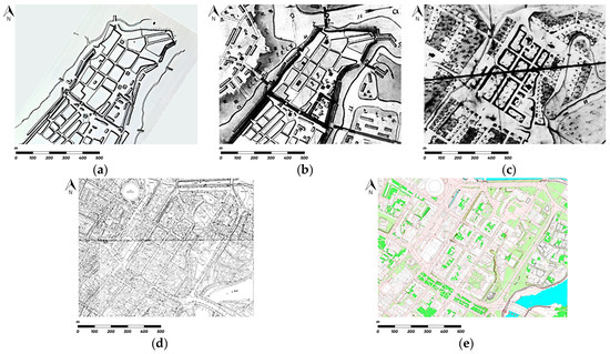
The next stage of the methodology focuses on identifying the most accurate and representative cartographic sources that can serve as a basis for reconstructing the historical landscape of the studied area. After preliminary alignment and comparison of archival maps, a search is conducted for maps that exhibit the smallest geometric errors and maintain the stability of spatial landmarks across different historical periods. To realize this, characteristic points of the terrain are analyzed: street intersections, natural boundaries, landscape forms, and remains of ancient fortifications that have survived on all or most plans.
During the comparison, it is determined which cartographic materials best convey the city’s original spatial structure. These, in this study, include the following:
- –
- The city plan of the Cossack era of 1750–1768, which reflects the oldest known topographic configuration of the settlement;
- –
- The city plan of 1845, which is one of the most accurate documents of the 19th century based on the results of map comparison (Section 4.3);
- –
- The detailed plan of the 1990s, developed using geodetic measurements;
- –
- The current detailed plan of 2025.
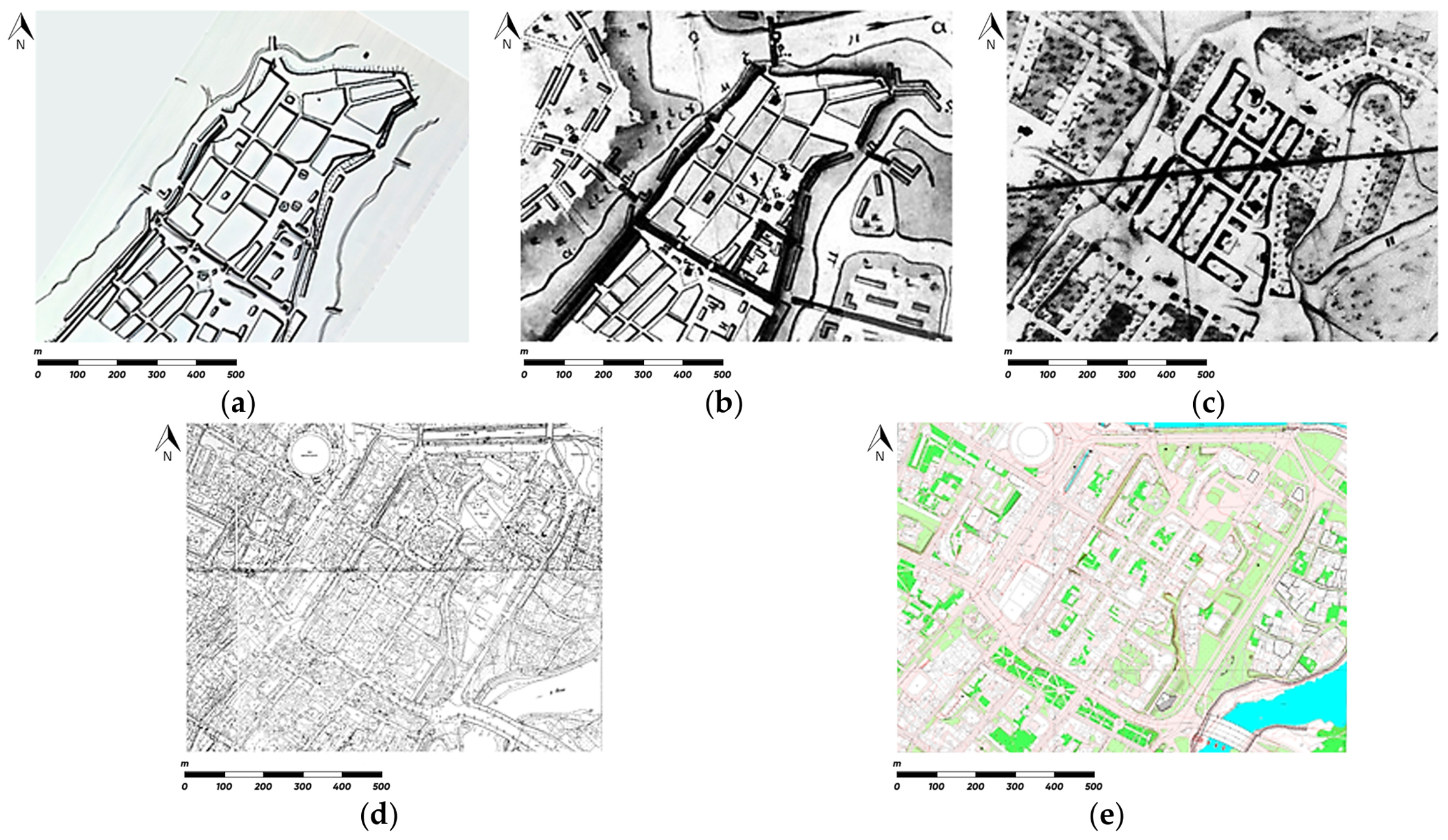
The set of these maps supports the reconstruction of the historical and topographic evolution of the urban landscape from the early settlement period to its current state (Figure 3).
Figure 3.
Historical maps of Sumy city from different periods: (a) 1750–1760s; (b) 1768; (c) 1845; (d) 1990s; (e) 2025.
These four reference maps support further georeferencing, the construction of a digital landscape model, and the reconstruction of historical landscape structures within the study area.
3.4. Georeferencing
During georeferencing in QGIS, the coordinate reference system (CRS) WGS 84/Pseudo-Mercator was used, corresponding to the World Geodetic System 1984 (EPSG:3857), which is used by Google Satellite.
Maps were added using the NextGIS QuickMapServices v.1.3.2 plugin and its Google Hybrid Web add-on (which supports highlighting street names). Historical maps in raster format *.JPG were loaded into QGIS using the Georeferencer Extension v.4.0.0 with the following settings: Transformation type–Polynomial 1 (Affine); Target CRS–EPSG:3857 (WGS 84/Pseudo-Mercator); Resampling method–Cubic (4 × 4 Kernel).
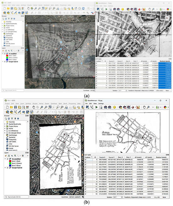
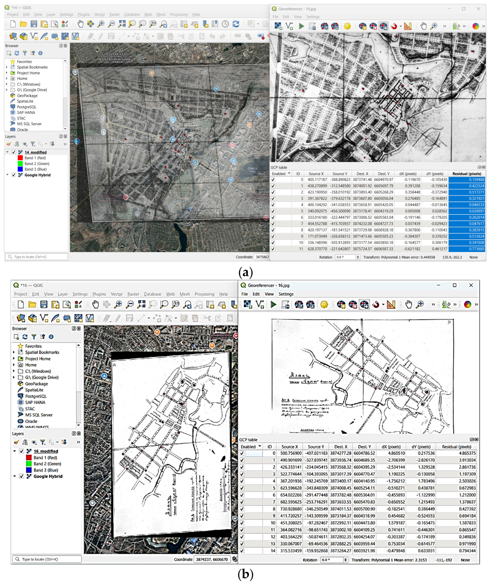
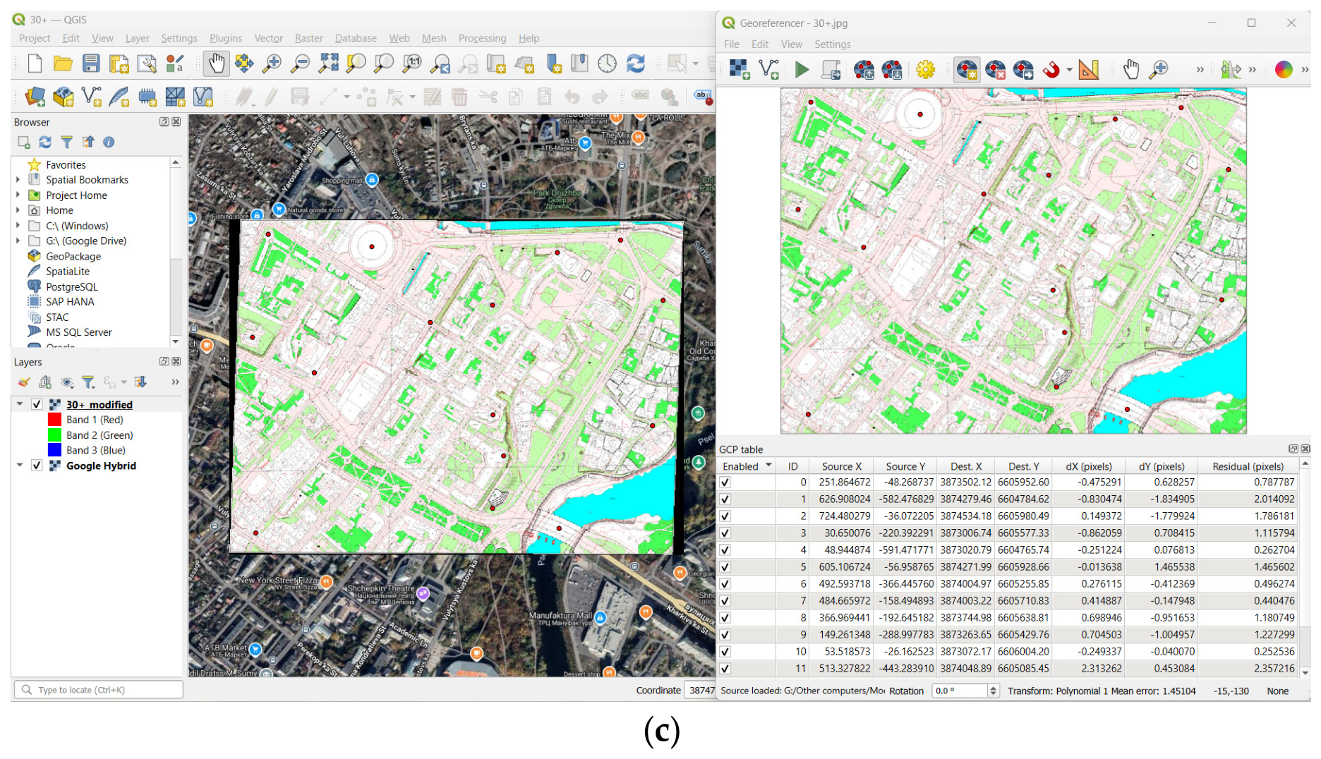
During processing, 15 stable ground control points (GCPs) per map were selected to cover the following features: map corners and the map center; characteristic curves of the Psel River, its tributaries, and bays; Chekh Lake; bridges; main streets, roads, and crossroads; and the historical center with ancient churches. Screenshots of the georeferencing procedure for various 19th-century maps are shown in Figure 4.
Figure 4.
Georeferencing the archival maps using QGIS software and the Georeferencer plugin: (a) 1845; (b) 1895; (c) 2025.
To evaluate the quality of the QGIS georeferencing, a mean error (ME) and a total root mean square (RMS) error were evaluated:
where MEQGIS—a mean error, automatically calculated by QGIS (in the bottom part of the Georeferencer plugin), px; PS—pixel size, determined via the “Properties” menu for each georeferenced archival map in a raster format *.TIFF, m/px; n = 15—the total number of GCPs; ei—residual error for the i-th GCP, px:
where dXi, dYi—the i-th residuals by the X- and Y-axes, respectively, px (according to the GCP table).
4. Results
4.1. Quality of Georeferencing
Generated by the Georeferencer and evaluated by formulas (1)–(3), statistical data are summarized in Table 2.
Table 2.
GCP statistics for different historical periods.
RMS values are sufficient for historical cartographic analysis based on maps of the 17th–19th centuries. As shown, georeferencing accuracy increases significantly from the 17th century (up to 9.1 m) to the 19th century (3.8 m).
4.2. Assessment of Historical Changes in Landscape Structure
The last stage of the methodology is aimed at the primary analysis of the territory’s landscape and at determining the nature of its anthropogenic transformation across different historical periods. Based on preselected, synchronized maps, a comparison of topographic elements is performed, enabling tracing changes in the natural morphology of the area under the influence of human activity. To realize this, parameters such as the shape and configuration of slopes and watershed lines, the location of gullies and ravines, changes in the flow of water bodies, and the imposition of artificial structures, namely the street network, planning elements, and engineering infrastructure, are analyzed.
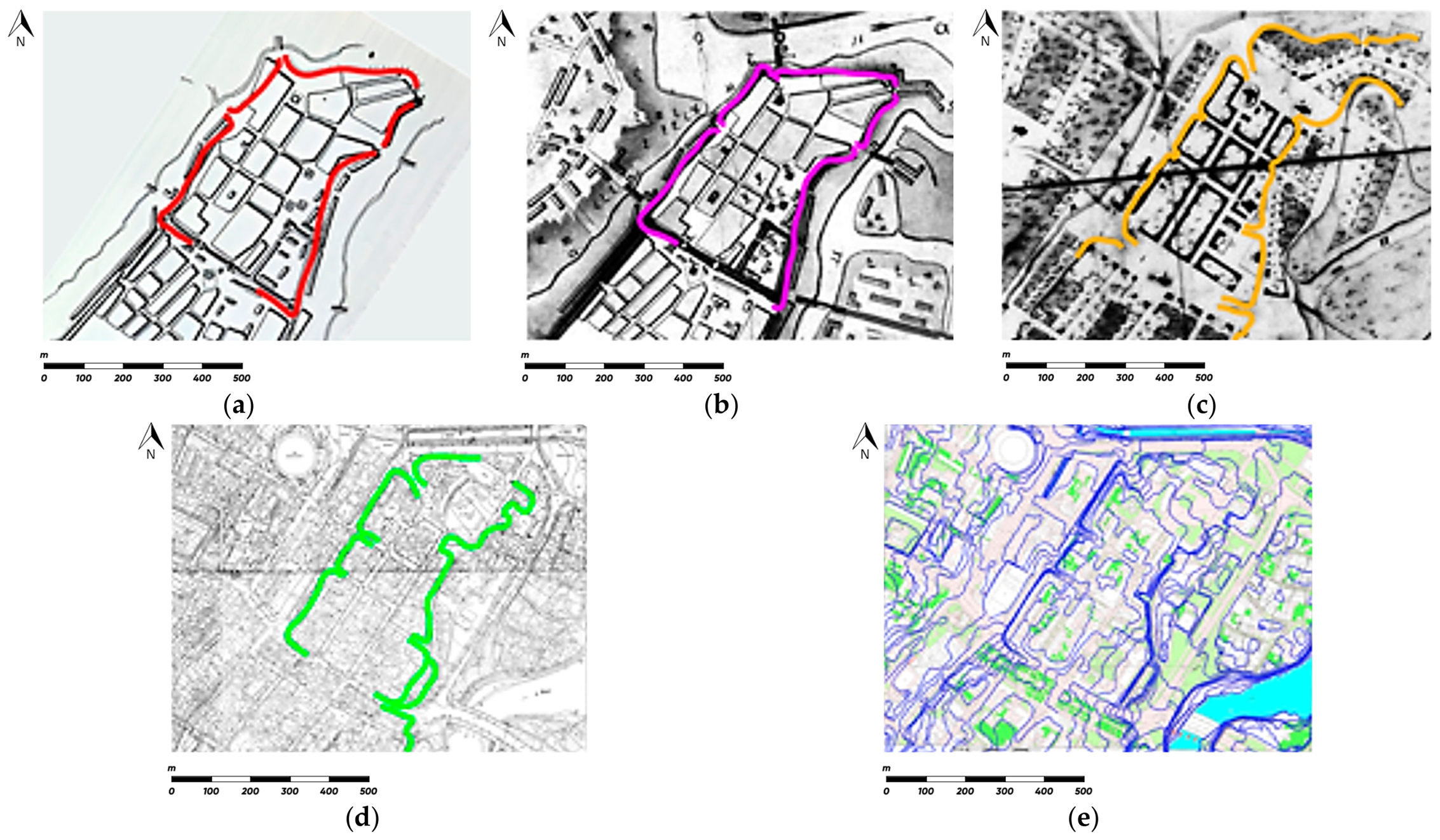
Based on the RMS analysis, a series of schematic graphic materials is formed, reflecting three levels of anthropogenic landscape change (Table 3, Figure 5):
Table 3.
Stages of anthropogenic landscape transformation.
Figure 5.
Anthropogenic transformation of the landscape: (a) 1750–1760s; (b) 1768; (c) 1845; (d) 1990s; (e) 2025.
- –
- Minimal, where the natural landscape retains its original features;
- –
- Moderate, where orderly changes related to the historical development of the city can be traced;
- –
- Critical, where natural forms are largely replaced or reshaped by modern development and engineering interventions.
These schemes support further post-war reconstruction of the historical landscape and clarification of the boundaries of its preserved fragments.
4.3. Refinement of a Landscape Transformation Model
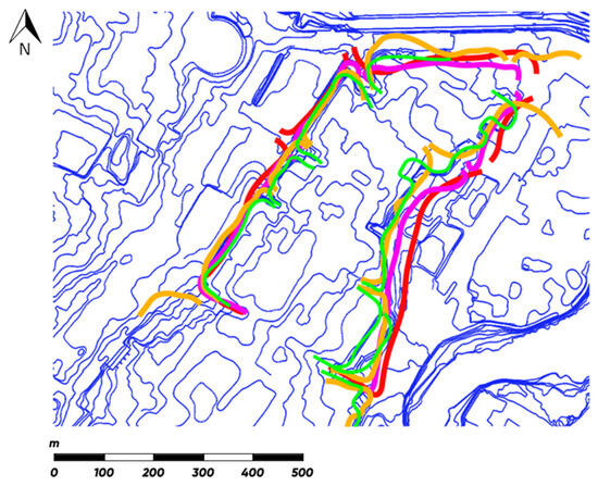
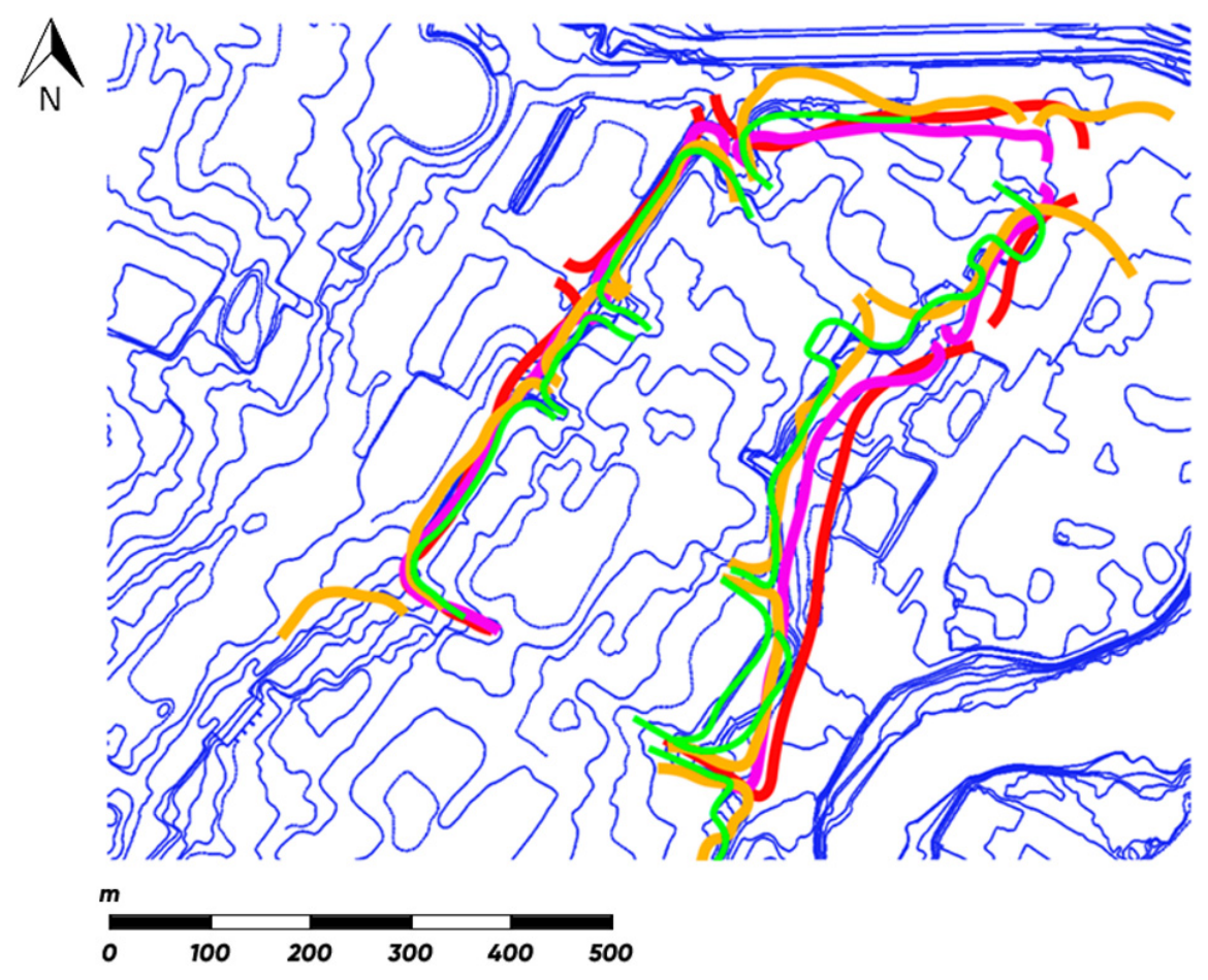
At this stage, the previously defined stages of anthropogenic landscape transformation are combined into a single generalized scheme. The resulting cartographic layers (minimum, moderate, and critical) are superimposed for comparison, to identify intersections, and to establish the zone of greatest reliability for morphological characteristics. After, raster images were refined without altering their spatial reference and geometric properties (Figure 6).
Figure 6.
A generalized scheme of anthropogenic transformation of the landscape with clarification according to the modern detailed plan: red—1750–1760s (critical transformation, RMS > 9 m); magenta—1768 (critical transformation, RMS > 9 m); yellow—1845 (moderate transformation, RMS < 9 m); green—1990s (minimal transformation, RMS < 3 m); blue—2025 (minimal transformation, RMS < 9 m).
This procedure increases the accuracy of reproducing historical and architectural morphological features and adapts the results of cartographic analysis to the coordinates of the current topographic base.
4.4. Results of the Analysis on Anthropogenic Changes in the Landscape
Among the collected cartographic material, the 1845 city plan proved the most relevant for reconstructing the historical morphology of the territory. It reflects the landscape structure, street network, block system, and individual architectural dominants in detail. Notably, during the 17th–19th centuries, the 1845 plan is the most accurate (the RMS value does not exceed 4 m). At the same time, modern maps are not meaningful given the lack of significant landscape changes (the RMS is less than 3 m). The corresponding explanation has been added to the manuscript.
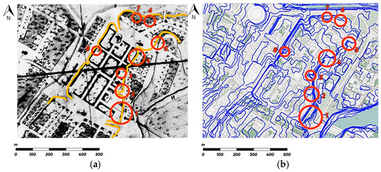
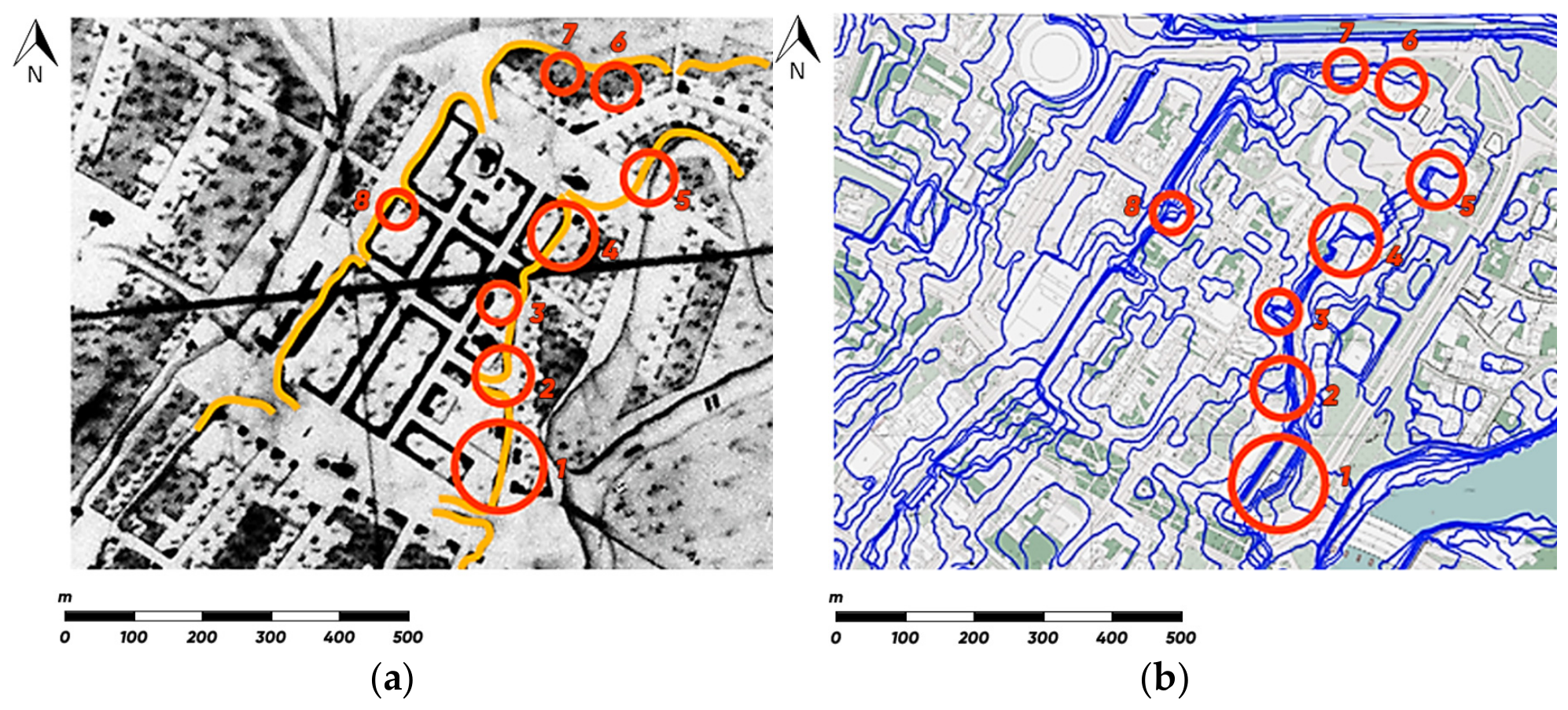
At this stage, a comparative analysis of the landscape configuration in 1845 and its current state in 2025 is carried out. Changes are being identified in the layout of the street network, the planning of neighborhoods, the boundaries of natural landscape forms, and the volume of earthworks performed, associated with the further urbanization of the territory (Figure 7).
Figure 7.
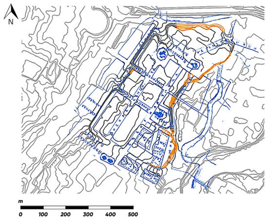
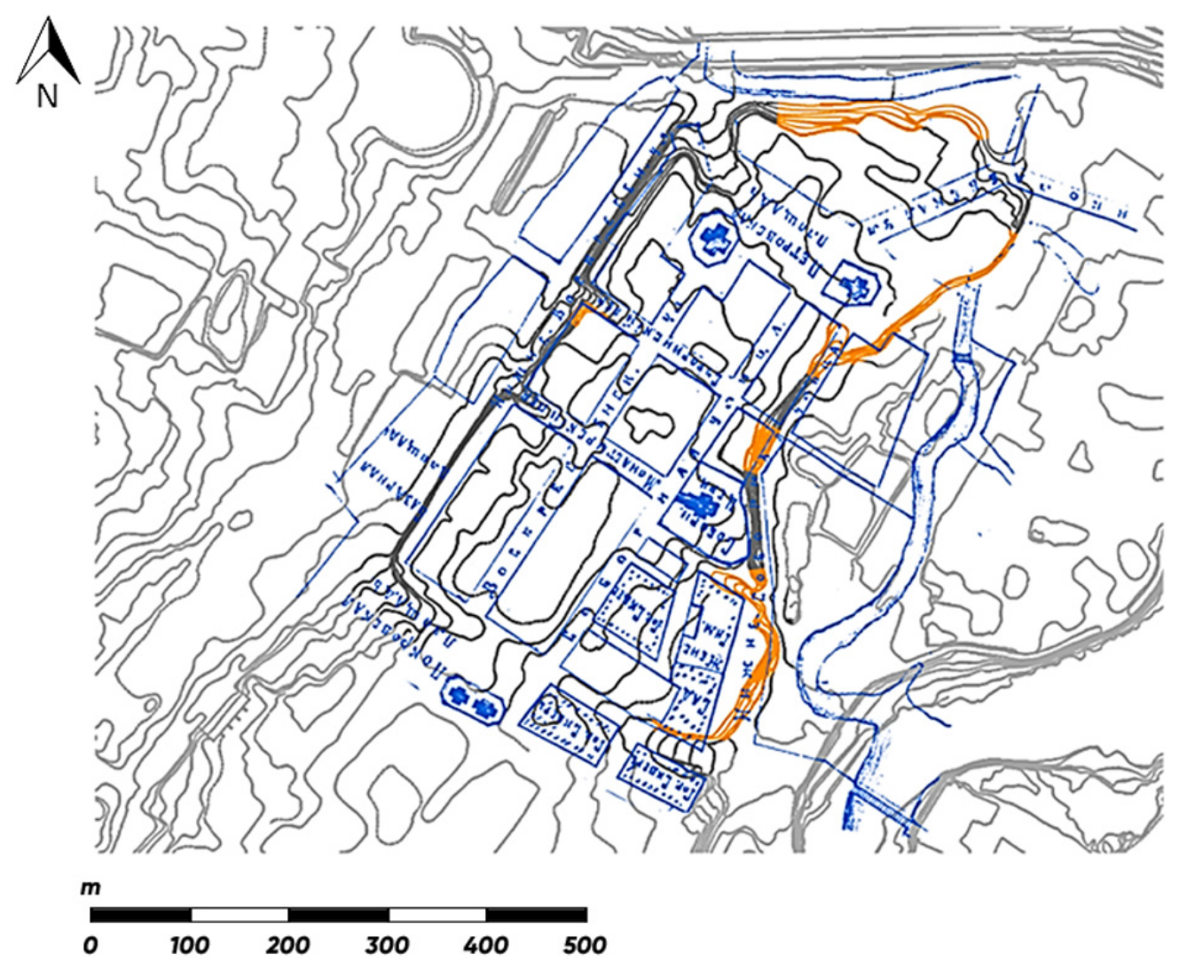
Comparative analysis of anthropogenic transformation of the landscape: (a) 1845 (yellow—landscape before transformation; red—zones after transformations, residual errors ei < 8 m according to Equation (3) and Figure 4a; (b) 2025 (red—landscape features; blue—modern landscape, residual errors ei ≤ 5 m according to Equation (3) and Figure 4c: 1—escarpment of the natural landscape in the area where the Cossack citadel was located; 2—levelling of the ravine, which served a defensive function during the Cossack period; 3—escarpment of the natural landscape in the area where the Cossack cemetery and the defensive rampart of the Cossack fortress were located; 4—escarpment of the natural landscape in the area of the intersection of Nyzhnosoborna Street and Petrivska Square; 5—escarpment of the natural landscape in the area of the historic quarter of Mykolaivska Street; 6—escarpment of the natural landscape in the area of Mykolaivska Street; 7—escarpment of the natural landscape of the right bank of the Sumka River; 8—escarpment of the natural landscape in the area where the defensive rampart of the Cossack fortress was located.
The red circles indicate the transformation of slopes and terraces above the river floodplain. On the 1845 plan (Figure 7a), the natural line of the coastal slope and the defensive rampart is clearly traced and marked in orange.
In contrast, a modern step-by-step analysis of the relief (Figure 7b, colored blue) shows significant leveling and cutting of these terraces under the influence of capital development and the laying of modern communications. The natural relief in this area has undergone significant anthropogenic modification, including terrain leveling, the creation of artificial escarpments, and site preparation for construction.
The marker No. 2 marks the leveling of the ravine, which in the Cossack period performed a defensive function. On the historical diagram, this area corresponded to the thalwegs of the ravine descending to the river. As of today, the ravine is almost filled in due to engineering construction.
Such analysis enables tracing which parts of the city have preserved their original topographic structure and which have undergone significant intervention, which is key to the correct reconstruction of the historical landscape.
4.5. Reconstruction of a Historical Landscape Model
At this stage, the landscape morphology is recreated as closely as possible to its historical state, based on a combination of data from a modern detailed plan and archival cartographic sources. The detailed plan of the central part of the city as of 2025 serves as the reference document, as it contains the most accurate geodetic parameters and reflects the current landscape. This foundation is superimposed on data from the 1845 plan, providing the restoration of the contours and landscape elements that were lost or significantly altered by anthropogenic transformation during the 19th and 20th centuries.
The additional overlay of the 1895 city center plan clarifies the configuration of the street network, the spatial boundaries of blocks, and their dynamic transformation. Comparing these sources provides a comprehensive understanding of how the topography and urban structure changed, which elements of the original landscape were preserved, and which were leveled or covered by new layers of development.
As a result, a reconstructed landscape model is formed, in which lost natural forms are recreated and key topographical dependencies are recorded, serving as a necessary prerequisite for the subsequent creation of a digital 3D reconstruction of the historical center of Sumy city (Figure 8).
Figure 8.
Digital reconstruction of the transformed landscape of the beginning of the 20th century: yellow—landscape before transformation; blue—modern landscape.
The vertical component (Z-axis) of the reconstructed terrain was derived from an official digital topographic plan provided by the Department of Architecture and Urban Planning of Sumy City Council (Ukraine), in *.DWG format.
The workflow for creating a 3D terrain model in SketchUp consisted of the following sequential stages. Initially, the main information base for building the model was the official digital topographic and geodetic plan of the city of Sumy at a scale of 1:2000 in DWG format. This file contained a 3D vector model of the existing terrain at a scale of 1:1 with geodetically verified and raised along the Z-axis isolines, which provided initial elevation marks.
After this, the DWG file was imported into the SketchUp workspace. To optimize the model and improve system performance, all extraneous layers (buildings, communications, vegetation) were turned off in the layer manager (Tags/Layers), leaving only the layer with three-dimensional relief horizontals.
Based on the previously conducted overlay analysis and comparison of archival maps that identified areas of anthropogenic change, the geometry of the original relief from 1845 was manually reconstructed. Using the Freehand tool or specialized plugins for drawing curves, such as Bezier Spline, lost, cut, and filled-in sections of historical contours were restored, in particular defensive ditches, original terrace slopes and ravines, combining them with unchanged fragments of the modern relief.
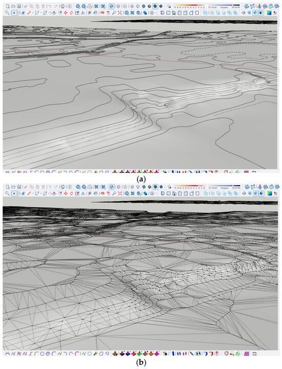
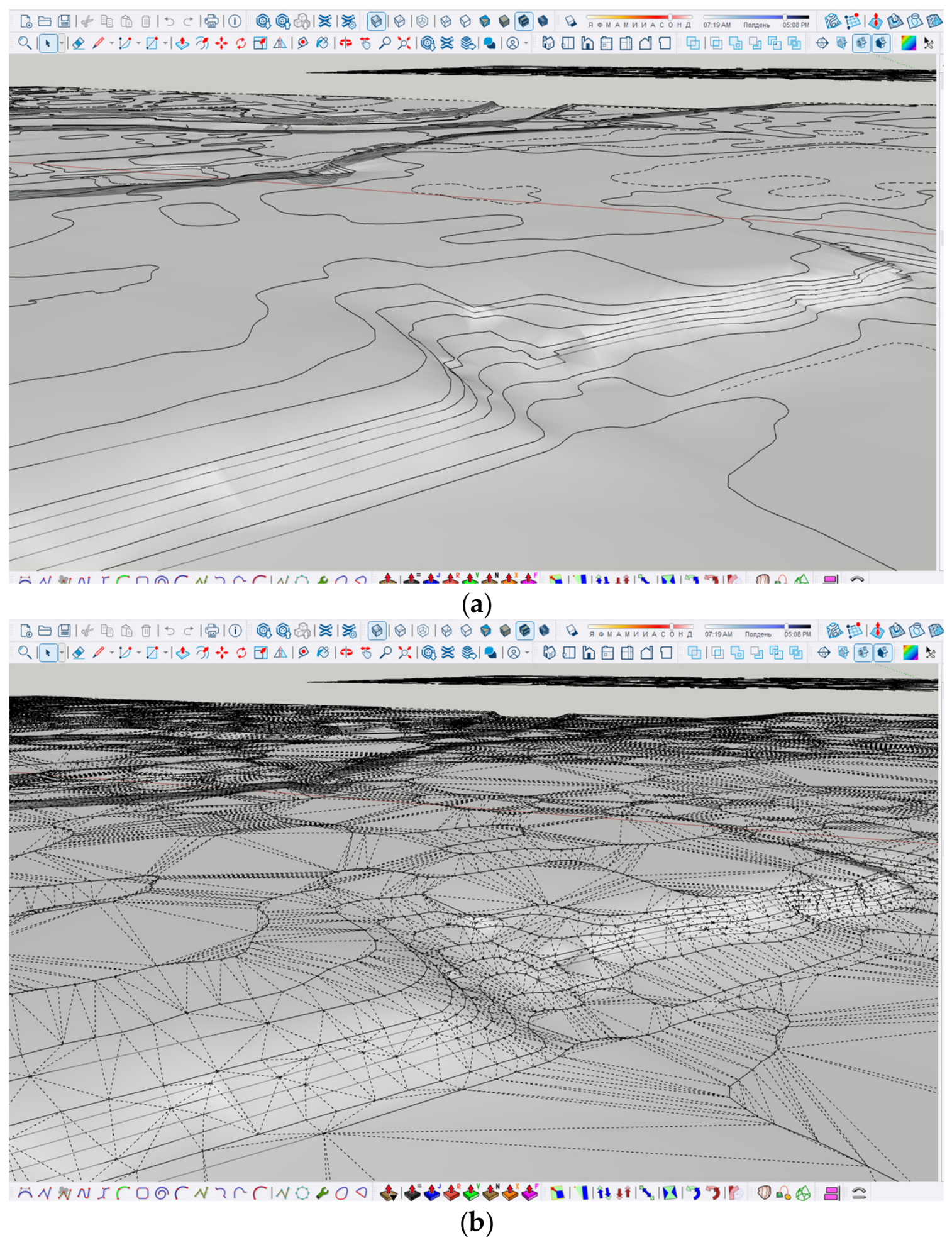
Finally, based on the corrected set of spatial contours, a continuous 3D surface was automatically generated using the Triangulated Irregular Network (TIN) in the standard Sandbox tool. This allowed the creation of a 3D digital model of the relief of the historical city center. Screenshots of the main stages are presented in Figure 9.
Figure 9.
Topographic contour lines for designing a 3D terrain model: (a) relief contours along the Z-axis; (b) geometry triangulation.
The dataset contained contour lines representing the contemporary terrain elevation, which were used to generate the 3D terrain surface.
Consequently, the terrain morphology reflects contemporary geodetic information, whereas the historical landscape interpretation is derived from archival cartographic sources. Therefore, the vertical component should be interpreted as representing the current terrain configuration underlying the reconstructed historical landscape rather than a direct reconstruction of historical elevations.
Although the terrain surface is based on official topographic contour data, historical terrain modifications resulting from urban development over the past centuries cannot be fully reconstructed because no historical elevation surveys are available. Therefore, the model represents the most plausible historical landscape consistent with both archival cartographic evidence and the contemporary terrain.
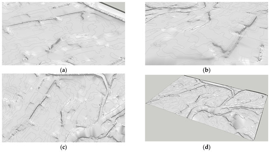
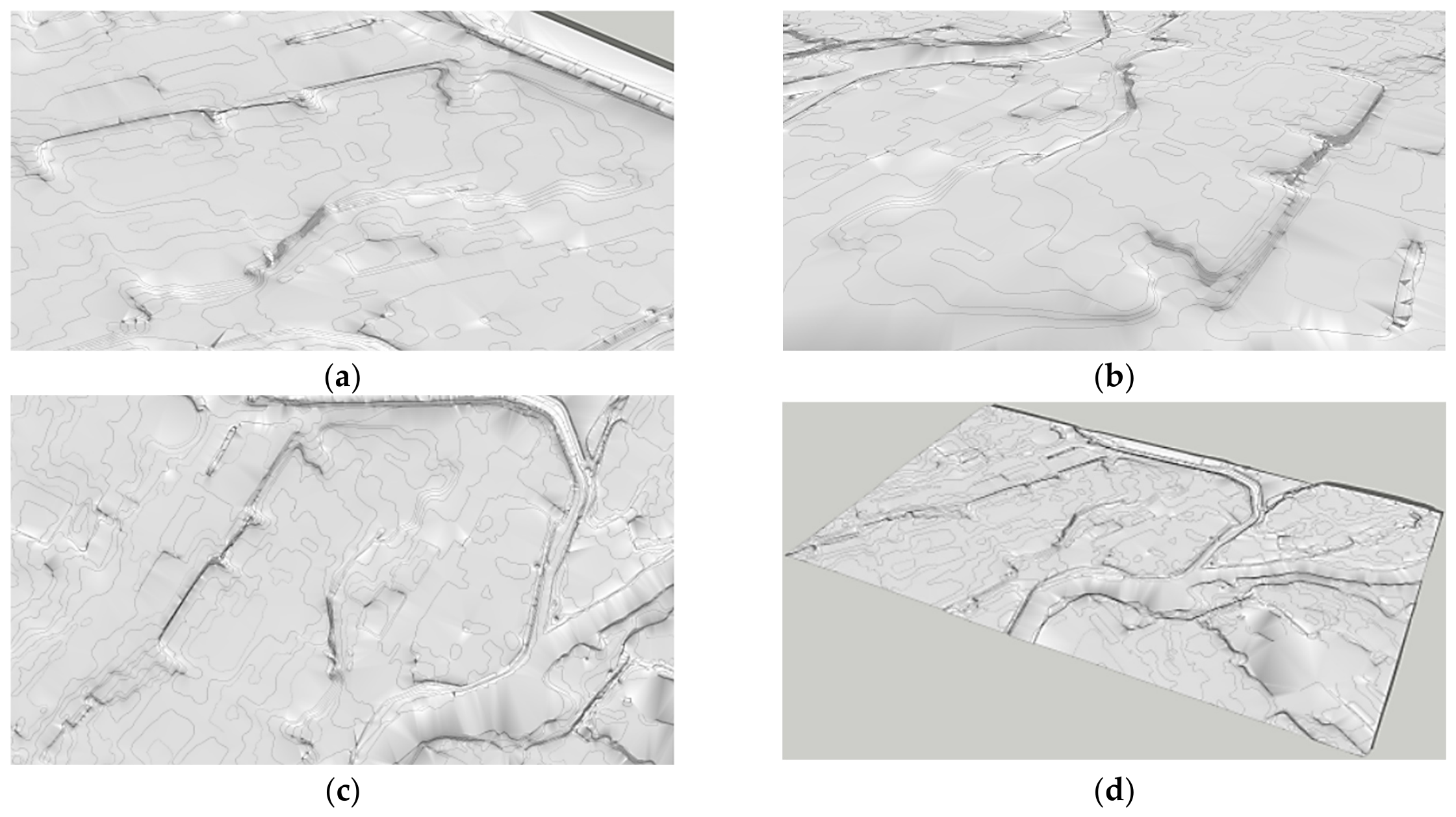
At this stage, based on the results of the previous cartographic analysis, a 3D reconstruction of the hypothetical landscape structure before anthropogenic transformation was performed (Figure 10).
Figure 10.
Patterns of 3D digital reconstruction of the landscape of the historical center of Sumy city: (a) left-side view; (b) right-side view; (c) top view; (d) general view.
SketchUp is used for modeling, enabling the reproduction of terrain surfaces, including elevations, slope lines, and restored landscape fragments.
The created 3D model supports further reconstruction of the historical city center, including the 3D reconstruction of historical quarters, the street network, buildings, and individual architectural objects of the early 20th century. Thanks to the restored landscape, it is possible to achieve a more realistic, authentic visual reproduction of the city’s spatial structure from that period.
5. Discussion
Based on the presented research algorithm, the scientific novelty of the work lies in the development and testing of a comprehensive methodology for the retrospective analysis and 3D reconstruction of the historical landscape of Sumy, Ukraine. The study proposes a sequential workflow for reconstructing historical urban landscapes that integrates archival cartography, GIS-based georeferencing, comparative spatial analysis, and 3D modeling within a unified methodological framework.
The main sources of uncertainty include map scale, surveying methods, cartographic generalization, and geometric distortions present on archival maps of different historical periods. Additional uncertainty arises from the disappearance or alteration of historical monuments, which may affect the identification of relevant reference objects during georeferencing. Moreover, local variations associated with historical anthropogenic earthworks or minor topographic changes may not be fully represented in terms of Z-coordinate. Therefore, the proposed 3D model should be interpreted as a morphologically consistent reconstruction suitable for historical landscape analysis, rather than as a high-resolution digital terrain model for engineering applications.
To minimize these effects, spatial alignment was performed using 15 GCPs per map, including churches, intersections, bridges, administrative buildings, and other permanent urban features. In addition, eighteen archival maps covering the period from the 1670s to 2025 were subjected to comparative analysis. Four reference maps with the highest cartographic reliability and completeness of information were selected for the reconstruction. The achieved georeferencing accuracy (RMS less than 4 m for the 19th century) is considered sufficient for comparative historical cartographic analysis based on eighteenth- and nineteenth-century maps and does not affect the identification of long-term patterns of landscape transformation.
Notably, the proposed approach focuses on reconstructing the historical morphology and development of the urban landscape rather than providing precise geodetic coordinates or the architectural reconstruction of individual buildings. Therefore, the resulting 3D model should be interpreted as a spatially consistent representation of the historical development of the landscape, suitable for heritage documentation, landscape analysis, and urban planning studies. However, further research could improve the accuracy of location determination by integrating additional archival sources, higher-resolution geospatial datasets, and quantitative uncertainty modeling.
The classification of anthropogenic landscape transformation enabled the development of a model to assess changes in the city’s natural morphology and identify three intervention levels: minimum, moderate, and critical. This identifies a clear distinction between the preserved primary forms of the landscape and areas of significant engineering transformations.
The digital reconstruction of the original landscape, based on the 3D model of the historical center of Sumy in SketchUp, is not only built on the buildings but also on the restored structure of the earth’s surface before the onset of active urbanization. Detecting a reference historical horizon serves as a basis for scientifically substantiating the choice of the 1845 plan as the most accurate primary source for the morphological reconstruction of the historical city center. The obtained results expand the understanding of the digital reconstruction of historical urban landscapes through multi-layer cartographic analysis, by improving the methods described in the literature worldwide [30,31,32].
Remarkably, the proposed methodology should be considered in the broader context of digital heritage reconstruction technologies. Current approaches based on short-range photogrammetry provide more accurate 3D models of existing monuments, buildings, and archaeological sites. The authors have extensive experience in 3D modeling and applying photogrammetric methods to document cultural heritage, as shown in [5,6,17]. However, these methods require the physical existence of the object being documented and therefore cannot be directly applied to the reconstruction of historical urban landscapes that have been significantly transformed or completely lost over several centuries.
The results have practical value for specialists in architecture, restoration, and urban management. Firstly, the developed methodology reveals a more accurate determination of the boundaries of the historical area of Sumy city based on preserved and transformed landscape elements. This is a practically helpful tool for developing historical and architectural reference plans for the city.
Secondly, the developed 3D landscape model serves as a digital basis for modeling new development objects and optimizing modern design in the historical city center. This identifies new objects to harmoniously align with the natural context and avoid critical violations of historical and architectural morphology.
Thirdly, engineering assessment of territories based on analysis of anthropogenic transformation degrees (minimum, moderate, and critical) helps to predict the complexity of earthworks and identify areas where the natural landscape requires special protection or restoration.
Moreover, digital restoration of cultural heritage based on a database of digitized and georeferenced archival maps can be integrated into the municipal geographic information system (GIS) to monitor the condition of the historical and architectural environment. The 3D reconstructed historical landscape provides a digital basis for visualizing the long-term evolution of the urban environment and can contribute to future research, heritage interpretation, and educational programs. Future research will also focus on integrating the reconstructed historical landscape with digital models of historical buildings, fortifications, transport infrastructure, and public spaces to achieve a more comprehensive reconstruction of the historic urban environment of Sumy, Ukraine.
6. Conclusions
This study proposes a methodology for reconstructing the historical urban landscape by integrating archival cartographic materials, comparative spatial analysis, and GIS-based georeferencing. The proposed approach enabled the reconstruction of the long-term evolution of the landscape in Sumy (Ukraine) using 18 archival maps spanning 3 centuries, providing a spatially consistent 3D representation of the city’s historical morphology.
Beyond the presented case study, the methodology provides a transferable framework for documenting and analyzing historical urban landscapes in cities where archival cartographic materials constitute the primary source of historical spatial information. Such an approach can support heritage documentation, historical landscape assessment, and scientifically informed post-war urban planning, preserving information about landscape features that have been altered or lost over time.
Nevertheless, the proposed approach should be interpreted with certain limitations. In particular, the reconstruction depends on the quality, completeness, and cartographic accuracy of available archival maps. Meanwhile, the model’s vertical Z-component is derived from modern elevation data and therefore represents the most plausible terrain morphology rather than a direct historical measurement. Therefore, the resulting 3D model is intended for historical landscape interpretation and comparative spatial analysis, and not for high-precision geodetic or architectural reconstruction. Moreover, the georeferencing procedure provides quantified spatial consistency of the input cartographic materials; however, it does not validate the historical accuracy of the reconstructed landscape itself.
Finally, in the context of increasing threats to cultural heritage caused by armed conflicts, the proposed methodology supports the long-term digital preservation of historical urban landscapes. It provides a reproducible framework for documenting endangered cultural environments before, during, and after reconstruction processes.
Future research should focus on improving the spatial accuracy of the reconstruction by integrating additional archival sources, standardized georeferencing procedures, uncertainty quantification, and independent validation with additional geospatial datasets. Combining archival mapping with modern methods (e.g., photogrammetry and LiDAR) is also a promising avenue for developing more comprehensive digital reconstructions of the historical urban environments.
Author Contributions
Conceptualization, I.T. and I.P.; methodology, I.T.; software, I.P. and I.T.; validation, I.P.; formal analysis, I.T.; investigation, I.T. and I.P.; resources, I.T.; data curation, I.P.; writing—original draft preparation, I.T. and I.P.; writing—review and editing, I.T. and I.P.; visualization, I.T. and I.P.; supervision, I.P.; project administration, I.P.; funding acquisition, I.P. All authors have read and agreed to the published version of the manuscript.
Funding
This research was funded by the Ministry of Education and Science of Ukraine, grant no.0125U000440: “Scientific Foundations of the Virtual Reconstruction of Destroyed Cultural Heritage Objects for the Recovery Strategy in Ukraine”, https://cm.sumdu.edu.ua/en/science/heritage (accessed on 29 July 2026).
Institutional Review Board Statement
Not applicable.
Informed Consent Statement
Not applicable.
Data Availability Statement
The data that support the findings of this study are available from the corresponding author upon reasonable request.
Acknowledgments
The authors appreciate the support of the Department of Architecture and Urban Planning of Sumy City Council and the Department of Culture, Tourism, and Religions of the Sumy Regional State Administration. The authors are also grateful to the AI-based language tool Grammarly for Windows for helping ensure the final text’s correctness and clarity without affecting the scientific content.
Conflicts of Interest
The authors declare no conflicts of interest.
References
- Medina, X.S. Is globalization a threat to Europe? Winning and losing territories in the first quarter of the twenty-first century. Soc. Sci. Humanit. Open 2025, 12, 102298. [Google Scholar] [CrossRef] [Scilit]
- Potapenko, S. Cossack officials in Sloboda Ukraine: From local elite to imperial nobility? In Dimensions of Modernity. The Enlightenment and Its Contested Legacies; Marczewski, P., Eich, S., Eds.; Institute for Human Sciences (IWM): Vienna, Austria, 2015; Volume 34, pp. 1–16. [Google Scholar]
- Rachkov, Y. Destruction, preservation, and rethinking of Ukraine’s urban cultural heritage during the Russo-Ukrainian war. J. V. N. Karazin Kharkiv Natl. Univ. Ser. Hist. 2022, 62, 12–48. [Google Scholar] [CrossRef] [Scilit]
- Rey-Pérez, J.; Roders, A.P. Historic urban landscape: A systematic review, eight years after the adoption of the HUL approach. J. Cult. Herit. Manag. Sustain. Dev. 2020, 10, 233–258. [Google Scholar] [CrossRef] [Scilit]
- Tytarenko, I.; Pavlenko, I.; Hrehova, S. 3D Reconstruction of a Virtual Building Environment. In Advanced Manufacturing Processes V. InterPartner 2023. Lecture Notes in Mechanical Engineering; Tonkonogyi, V., Ivanov, V., Trojanowska, J., Oborskyi, G., Pavlenko, I., Eds.; Springer: Cham, Switzerland, 2024; pp. 105–114. [Google Scholar] [CrossRef] [Scilit]
- Tytarenko, I.; Machado, J.; Pavlenko, I. Digitization of architectural heritage objects using photogrammetry: Sumy Region case study. J. Eng. Sci. 2025, 12, E18–E28. [Google Scholar] [CrossRef] [Scilit] [PubMed]
- Danylchenko, O.S.; Kornus, A.O.; Kornus, O.H.; Vynarchuk, O.O. Assessment of the geo-ecological potential of the landscape districts (on the example of Sumy region, Ukraine). J. Geol. Geogr. Geoecol. 2021, 30, 13–24. [Google Scholar] [CrossRef] [Scilit] [PubMed]
- Danylchenko, O.S.; Rybalchenko, A.S. Evaluation of Geoecological State of River Sumka in the City of Sumy. Sci. Notes Sumy State Pedagog. Univ. Named After A. S. Makarenko Geogr. Sci. 2017, 8, 25–30. [Google Scholar] [CrossRef] [Scilit]
- UNESCO. Damaged Cultural Sites in Ukraine Verified by UNESCO. Available online: https://www.unesco.org/en/ukraine-war/damaged-cultural-sites (accessed on 14 July 2026).
- Zhang, W.; Kolisnyk, O. Urban landscape and digital preservation of heritage sites: A case study of the ancient city of Shandan in Gansu, China. Art Des. 2024, 3, 143–155. [Google Scholar] [CrossRef] [Scilit]
- Wu, S.; Chen, Y.; Gribaudi, M.; Schindler, K.; Mallet, C.; Perret, J.; Hurni, L. Deep learning enables urban change profiling through alignment of historical maps. arXiv 2026. submitted. [Google Scholar] [CrossRef] [Scilit]
- Tobiáš, P.; Cajthaml, J.; Krejčí, J. Rapid reconstruction of historical urban landscape: The surroundings of Czech chateaux and castles. J. Cult. Herit. 2018, 30, 1–9. [Google Scholar] [CrossRef] [Scilit]
- Turner, M. Heritage and conservation of the historic urban landscape. In Evolving Heritage Conservation Practice in the 21st Century. Creativity, Heritage and the City; Cameron, C., Ed.; Springer: Singapore, 2023; Volume 5, pp. 19–31. [Google Scholar] [CrossRef] [Scilit]
- Herold, H.; Hecht, R. 3D Reconstruction of urban history based on old maps. In Digital Research and Education in Architectural Heritage. UHDL DECH 2017; Münster, S., Friedrichs, K., Niebling, F., Seidel-Grzesińska, A., Eds.; Communications in Computer and Information Science; Springer: Cham, Switzerland, 2018; Volume 817, pp. 63–79. [Google Scholar] [CrossRef] [Scilit]
- Morlighem, C.; Labetski, A.; Ledoux, H. Reconstructing historical 3D city models. Urban Inform. 2022, 1, 11. [Google Scholar] [CrossRef] [Scilit] [PubMed]
- Bent, G.R.; Pfaff, D.; Brooks, M.; Radpour, R.; Delaney, J. A practical workflow for the 3D reconstruction of complex historic sites and their decorative interiors: Florence as it was and the church of Orsanmichele. Herit. Sci. 2022, 10, 118. [Google Scholar] [CrossRef] [Scilit]
- Tytarenko, I.; Pavlenko, I.; Dreval, I. 3D modeling of a virtual built environment using digital tools: Kilburun fortress case study. Appl. Sci. 2023, 13, 1577. [Google Scholar] [CrossRef] [Scilit]
- Ciampi, P.; Giannini, L.M.; Esposito, C.; Younsi, S. Reconstructing urban landscape evolution with historical maps and geophysical techniques: 3D time-sensitive and multi-source geomodelling. Environ. Earth Sci. 2025, 84, 253. [Google Scholar] [CrossRef] [Scilit]
- Kaňuk, J.; Gallay, M.; Hofierka, J. Generating time series of virtual 3-D city models using a retrospective approach. Landsc. Urban Plan. 2015, 139, 40–53. [Google Scholar] [CrossRef] [Scilit]
- Ezz, M.S.; Soliman, A.M.; Aldelgawy, M.; Salem, D.A.H.; Khalil, R. Utilizing 3D GIS for the sustainable management of UNESCO World Heritage sites in Saudi Arabia. Front. Built Environ. 2025, 11, 1550124. [Google Scholar] [CrossRef] [Scilit]
- Şenyurdusev, G.; Dogru, A.O. Infrastructure for 3D modeling of historical fountains in Istanbul with GIS-based procedural approach. Geomat. Environ. Eng. 2024, 18, 51–72. [Google Scholar] [CrossRef] [Scilit]
- Huang, Y.; Shi, Z.; Chen, Y.; Zhou, K.; Ying, Z.; Zheng, L.; Yang, S. Urban form evolution and transformation of traditional water towns based on space syntax and GIS: Evidence from ancient Wenzhou city (16th to the 20th century). Front. Earth Sci. 2025, 13, 1520643. [Google Scholar] [CrossRef] [Scilit]
- Deng, Z.; Hijazi, I.; Kolbe, T.H. CityGML 3.0 as a hub: Integrating BIM, GIS, and point cloud data for 3D streetspace modeling comprising roads, bridges and tunnels. ISPRS Ann. Photogramm. Remote Sens. Spat. Inf. Sci. 2025, X-4/W6-2025, 65–72. [Google Scholar] [CrossRef] [Scilit]
- Zawadzki, J.; Medyńska-Gulij, B. Cartographic sources in the immersive geovisualization of a medieval stronghold. Abstr. Int. Cartogr. Assoc. 2024, 7, 190. [Google Scholar] [CrossRef] [Scilit]
- Li, J.; Liu, M.; Jiao, Y. Research progress on digital and immersive methods for historic garden reconstruction. In AIVRID ’25: Proceedings of the 2025 International Conference on Artificial Intelligence, Virtual Reality and Interaction Design. AIVRID ’25, Dongguan, China, 17–19 October 2025; Association for Computing Machinery: New York, NY, USA, 2025; pp. 775–781. [Google Scholar] [CrossRef] [Scilit]
- Ciccone, G.; Frisetti, A.; Abate, N.; Goffredo, R.; Dato, G.; Amodio, A.M.; Sileo, M.; Lasaponara, R.; Masini, N. Unveiling medieval landscapes: A virtual reconstruction through LiDAR and extended matrix methodology, the case of Torre di Castiglione (BA). Digit. Appl. Archaeol. Cult. Herit. 2025, 39, e00464. [Google Scholar] [CrossRef] [Scilit]
- Milovanović, A.; Šošević, U.; Cvetković, N.; Pešić, M.; Janković, S.; Krstić, V.; Ristić Trajković, J.; Milojević, M.; Nikezić, A.; Simić, D.; et al. Mapping digital solutions for multi-scale built environment observation: A cluster-based systematic review. Smart Cities 2025, 8, 196. [Google Scholar] [CrossRef] [Scilit]
- Zu, X.; Gao, C.; Liu, Y.; Zhao, Z.; Hou, R.; Wang, Y. Machine intelligence for interpretation and preservation of built heritage. Autom. Constr. 2025, 172, 106055. [Google Scholar] [CrossRef] [Scilit]
- Tytarenko, I.; Pavlenko, I. Primary cartographic data from 1670–1913 for analyzing the landscape of Sumy city. DataverseUA 2026. [Google Scholar] [CrossRef]
- Xue, C.; Zheng, X.; Zhang, B.; Yuan, Z. Evolution of a multidimensional architectural landscape under urban regeneration: A case study of Jinan, China. Ecol. Indic. 2015, 55, 12–22. [Google Scholar] [CrossRef] [Scilit]
- Rey-Pérez, J.; Ávila, M.E.S. Historic urban landscape: An approach for sustainable management in Cuenca (Ecuador). J. Cult. Herit. Manag. Sustain. Dev. 2017, 7, 308–327. [Google Scholar] [CrossRef] [Scilit]
- Tabur, B.D.; Kul, F.N. Reconstructing lost heritage: Digital presentation of 19th century rural landscape of Gülbahçe (İzmir, Türkiye). Digit. Appl. Archaeol. Cult. Herit. 2026, 40, e00490. [Google Scholar] [CrossRef] [Scilit]

Disclaimer/Publisher’s Note: The statements, opinions and data contained in all publications are solely those of the individual author(s) and contributor(s) and not of MDPI and/or the editor(s). MDPI and/or the editor(s) disclaim responsibility for any injury to people or property resulting from any ideas, methods, instructions or products referred to in the content. |
© 2026 by the authors. Licensee MDPI, Basel, Switzerland. This article is an open access article distributed under the terms and conditions of the Creative Commons Attribution (CC BY) license.