1. Introduction
The Scan-to-BIM (or Scan2BIM) processes allow the reconstruction of 3D models through point cloud processing, which involves the extraction of key features for the construction of building information modeling (BIM) [
1,
2,
3]. Consequently, this process takes into account two fundamental phases, namely, the construction and management of a point cloud and the subsequent construction of a simple, parametric model.
The construction of a 3D point cloud can be achieved via image-based 3D modeling (IBM) or range-based modeling (RBM) [
4]. IBM approaches utilize two-dimensional images obtained from passive sensors to construct three-dimensional models, typically employing algorithms like structure from motion (SfM) and multi-view stereo (MVS). In addition, the passive sensors in the IBM framework can be utilized on mobile platforms, such as cranes, unmanned aerial vehicles (UAVs), and hot-air balloons, enabling the collection of data from large, complex, and hard-to-access structures, including the upper areas of buildings, aqueducts, and bridges [
5,
6]. In contrast, RBM employs active sensors that deliver a highly detailed and precise representation of a three-dimensional object or structure [
7]. A notable example of an active sensor is the Terrestrial Laser Scanner (TLS), which generates accurate, dense point clouds of a scene through laser range-finding techniques. In recent years, there have been significant developments in SLAM (Simultaneous Localization and Mapping) applied to the construction of 3D point clouds. These advances have focused on improvements in accuracy, computational efficiency, and the integration of new types of sensors for the generation of increasingly detailed and precise 3D maps. SLAM reliably captures simple geometries but loses detail in more intricate architectural areas. SLAM’s suitability for quick documentation highlights its limitations in complex environments [
8]. SLAM is increasingly used in AEC to support automation and real-time mapping on complex construction sites, but its performance is limited by dynamic conditions and sensor constraints. Emerging methods like sensor fusion and semantic mapping improve results, yet full BIM integration and robust real-time operation remain challenges for future development [
9].
Recent advances in deep learning have enabled fully automated semantic segmentation of BIM elements directly from point cloud data. Perez-Perez et al. (2021) [
10] presented an innovative end-to-end deep learning approach called Scan2BIM-NET, designed for the semantic segmentation of structural, architectural, and mechanical elements found in point cloud data; this latter method effectively categorizes components such as beams, ceilings, columns, floors, pipes, and walls through the utilization of three primary networks: two convolutional neural networks (CNNs) and one recurrent neural network (RNN). The training and testing of this method were conducted using point cloud data from 83 rooms, which represent actual industrial and commercial buildings. Qiu et al. (2022) [
11] introduced a methodology that can be outlined in two phases; the initial phase involves geometry-based segmentation to detect edge points and non-planar points, which hold essential geometric information. Therefore, following this latter method, a semantic-based segmentation was executed to pinpoint points that possess significant semantic information. Song et al. (2023) [
12] proposed an assistive Scan-to-BIM system that takes the raw sensor data and edit history (including the current conceptual BIM model), then auto-regressively predicts a sequence of model editing operations as APIs of a professional BIM software (i.e., Autodesk Revit). Klapa and Gawronek (2023) [
13] described a Scan2BIM procedure to build high-quality heritage BIM (HBIM) models for cultural heritage based on the accurate integration of TLS and UAV data into a consistent, georeferenced database. Pepe et al. (2024) [
14] wrote about an efficient solution to transform the point cloud into parametric objects by four main steps: 3D survey of the structure under investigation, generation of a new point cloud based on feature extraction and identification of suitable threshold values, geometry reconstruction by semi-automatic process performed in Rhinoceros/Grasshopper, and BIM implementation.
However, much of the work has been done with expensive devices and commercial software; therefore, a full development of a Scan-to-BIM process must be based on simple, innovative, and accessible tools. Therefore, this work intends to pave the way for the use of open-source tools and guarantee a transparent, simple process, controllable in every step and accessible to all users, and to assess the feasibility of these approaches in creating reliable and detailed 3D representations within the architecture, engineering, and construction (AEC) environment.
While several Scan-to-BIM studies have explored either open-source photogrammetry, low-cost sensing, or conceptual BIM modeling independently, fewer works address the full Scan-to-BIM pipeline in an integrated and standards-aware manner. The scientific contribution of this research lies in proposing an end-to-end, cost-effective Scan-to-BIM workflow that combines low-cost SLAM-based acquisition, open-source photogrammetry (COLMAP v 3.14.0), and openBIM modeling tools (BlenderBIM/IfcOpenShell) within a single reproducible framework. Unlike many existing open-source approaches that focus on isolated processing stages or purely experimental pipelines, the proposed method explicitly links data acquisition, verification, and BIM modeling to ISO 19650 principles and ISO 7817:2024 Level of Information Need (LIN) [
15,
16]. Furthermore, the workflow is experimentally validated through a direct comparison with terrestrial laser scanning (TLS) and commercial photogrammetry software under identical case-study conditions, enabling a transparent assessment of accuracy, limitations, and applicability for different BIM use cases.
2. State of the Art
2.1. Brief Introduction
Open-source software (OSS) is gaining widespread use and recognition. These programs are free to use, share, and modify. Their licenses allow users to run them for any purpose, study how they work, change the code, and distribute original or modified versions without paying fees to the original developers [
17]. Using OSS in photogrammetry is important because it makes 3D modeling tools more accessible to everyone. Unlike expensive commercial programs, open-source options are free and can be used by students, researchers, small companies, and institutions with limited budgets. They also allow users to customize the tools for their specific needs and share improvements with the community.
2.2. BIM in Open-Source Software
OSS has become increasingly significant in the field of BIM, offering architects, engineers, and construction professionals flexible and cost-effective tools for project design and management. It is well known that BIM is far more than 3D models and open formats (i.e., IFC). By definition (ISO 19650-1) [
18], BIM represents the use of a shared digital representation of a built asset to facilitate design, construction, and operation processes to form a reliable basis for decisions. These built assets include, but are not limited to, bridges, roads, process plants, and, of course, cultural heritage buildings. Even this standard definition of BIM does not manage to comprehensively explain what BIM is, and, on this line, for the purpose of this paper, the authors define BIM as “an integrated information framework that manages the entire data lifecycle, connecting geometric, semantic, and contextual information to enable digital conservation and visualization-oriented documentation of historical assets through interoperable and reliable data for informed decision-making”.
Table 1 presents the details of free and open-source tools used for conceptual BIM modeling.
2.3. Generation of the Point Cloud by Photogrammetry Open-Source Software
Point cloud generation through photogrammetry, particularly using open-source software, has gained significant attention due to its accessibility, cost-effectiveness, and versatility in creating accurate 3D models.
Table 2 shows the main previous research works in this field.
2.4. Generation of the Point Cloud by Low-Cost Active Sensors and Devices
SLAM with LiDAR or RGB-D cameras supports real-time mapping for robotics and heritage preservation. Smartphones and tablets with depth sensors (e.g., Apple LiDAR) enable portable, cost-effective scanning via apps such as Polycam and SiteScape [
37]. Despite challenges like noise and accuracy limits, advances in hardware and algorithms improve low-cost point cloud quality. The advent of low-cost active sensors, particularly those integrated into smartphones, has revolutionized the generation of point clouds for various applications, including urban surveying, visualization-oriented architectural documentation, and environmental monitoring. Smartphone-based LiDAR has achieved centimetric accuracies under favorable conditions, although surface noise and planarity degradation remain common limitations [
38]. Comparative evaluations on the iPhone 13 Pro have also demonstrated that the performance of mobile mapping is strongly influenced by the scanning application used, with promising results for indoor navigation and floor-plan generation but with tracking stability still presenting challenges [
39]. Additional research on iPhone and iPad LiDAR has shown that these sensors enable fast reconstruction workflows for high-resolution topographic and change-detection tasks, allowing rapid generation of detailed 3D models in both indoor and outdoor scenarios [
40]. Studies on LiDAR-based SLAM approaches have further confirmed that low-cost sensors can reliably capture indoor building geometries in real time, while noting that drift and tracking failures remain common in featureless or repetitive environments [
41].
Beyond Apple devices, other low-cost LiDAR technologies have also been investigated in geomatics. For example, rotating multi-beam sensors such as the Velodyne VLP-16 have been integrated into custom terrestrial platforms, demonstrating that affordable LiDAR units can produce sufficiently dense and coherent point clouds for building-scale documentation, albeit with lower fidelity than high-end TLS systems [
42]. Similarly, several studies have assessed handheld LiDAR-based SLAM devices for mapping constrained or underground environments, highlighting their mobility and rapid acquisition advantages while acknowledging typical issues such as drift accumulation and incomplete coverage [
43]. Low-cost UAV-mounted LiDAR solutions have also been applied to topographic surveys, revealing that lightweight airborne units can deliver usable terrain models for geomatic applications, even though they generally exhibit higher noise levels and reduced point density compared to professional airborne systems [
44].
3. Method
Before describing the proposed Scan-to-BIM workflow, it is necessary to frame it within a coherent BIM structure. According to ISO 19650 and ISO 7817:2024, BIM extends beyond model creation to a verifiable information process linking intent to validation. The success of any 3D data acquisition depends on clearly defining why the data are collected, what information is needed, and how quality will be evaluated.
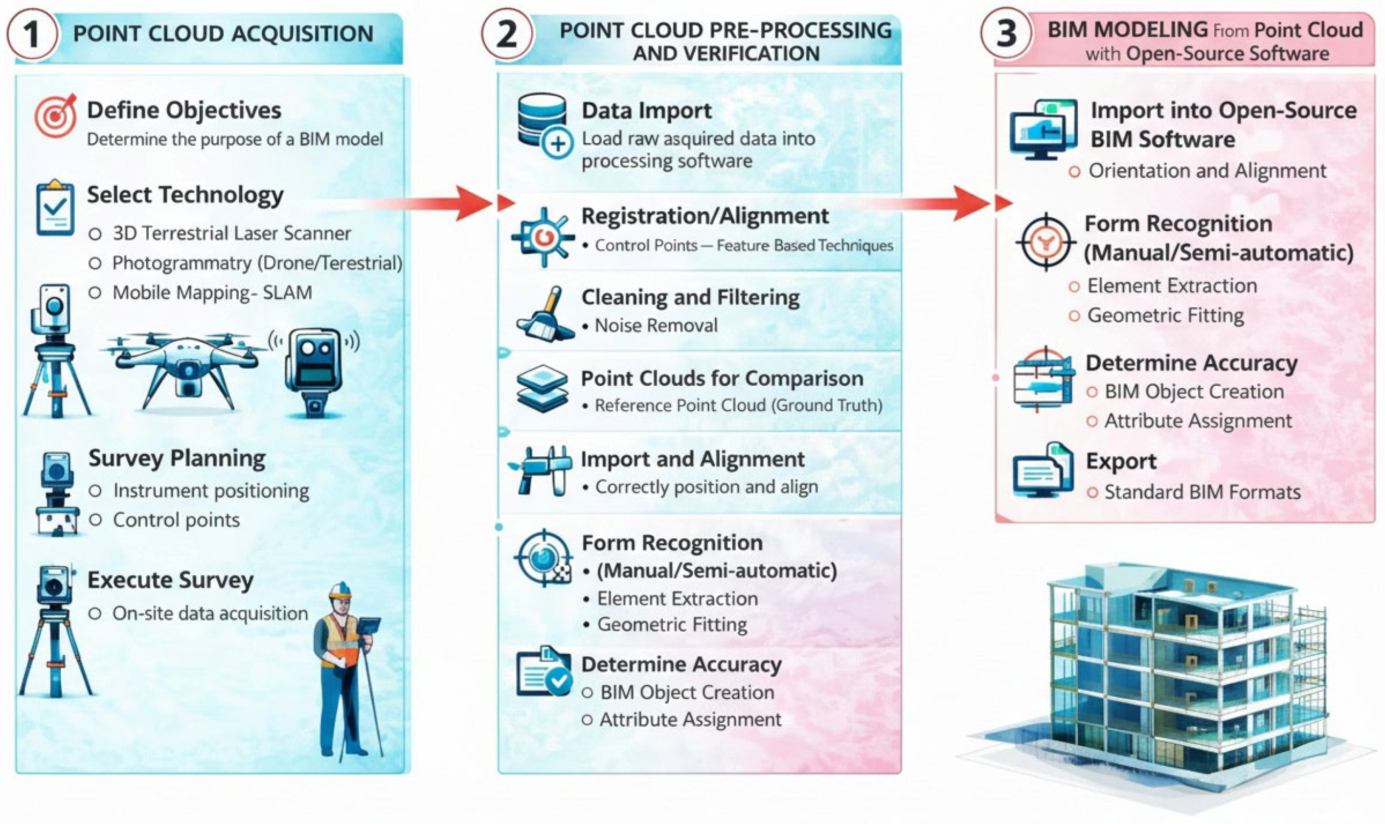
The process begins by identifying the BIM use case (visualization-oriented documentation, conservation, structural analysis, or digital-twin development) to ensure alignment with project objectives. Information requirements are then defined across three levels: (i) geometric, specifying resolution and reliability for faithful representation; (ii) alphanumeric, including material, phase, and condition metadata; and (iii) visualization-oriented documentation, encompassing survey reports and historical records. Each requirement includes acceptance criteria for accuracy and tolerance, enabling objective verification and reliable results. Once these parameters are set, information development proceeds through open-source and openBIM tools, followed by validation against predefined standards. By defining these criteria early, practitioners can assess the suitability of low-cost SLAM sensors, photogrammetry, or hybrid methods for specific applications. The proposed workflow, illustrated in
Figure 1, integrates affordable SLAM-based data capture and/or with open-source processing to deliver accessible, efficient, and verifiable conceptual BIM models.
The proposed Scan-to-BIM workflow follows a structured yet flexible process designed to ensure accuracy, interoperability, and accessibility within an openBIM environment. It begins with point cloud acquisition, where the purpose of the conceptual BIM model (whether for visualization-oriented documentation, renovation, or facility management) is defined, and the most appropriate technology is selected. Depending on project needs, this may involve terrestrial laser scanning, drone or terrestrial photogrammetry, or low-cost SLAM-based mobile mapping. Careful planning of survey routes, instrument positioning, and control points ensures comprehensive and precise data capture.
Once collected, the data undergo pre-processing, where multiple scans are imported, aligned, and cleaned. Techniques such as control-point registration and iterative closest point (ICP) algorithms integrate the datasets into a single coordinate system, while noise filtering and down-sampling optimize performance and maintain quality.
The next step focuses on verification and comparison of the point clouds to assess their reliability. Reference datasets obtained from high-precision instruments are compared with those produced using low-cost or open-source methods. Color deviation maps and statistical indicators, including RMS and mean deviations, help evaluate whether the results meet the Level of Information Need (LIN) defined by ISO 7817:2024. Following verification, conceptual BIM modeling is performed within open-source platforms such as FreeCAD, BlenderBIM (Bonsai), or IfcOpenShell. Architectural and structural components are reconstructed as parametric objects enriched with geometric and semantic attributes, ensuring that the model conveys both form and information.
Finally, the validation phase confirms the model’s geometric and informational accuracy. Tools such as the Information Delivery Specification (IDS) and the buildingSMART Data Dictionary (bSDD) enable automated checking of attributes, naming conventions, and tolerances, ensuring compliance with ISO 19650 principles. This integrated approach transforms validation into a transparent, repeatable process.
A case study demonstrates the workflow’s reliability and effectiveness, comparing open-source results with TLS and commercial outputs. The procedure focuses on the analysis of data quality and on assessing the feasibility of generating complete and coherent conceptual BIM models from low-cost data sources, with three-dimensional visualization treated as one functional component of the BIM workflow.
4. Experimentation on the Case Study
4.1. General Approach
The following case studies demonstrate the application of the proposed open-source Scan-to-BIM workflow in a 3D visualization context for cultural heritage. The goal is to produce a visually accurate and semantically coherent digital model suitable for visualization-oriented documentation and dissemination rather than sub-millimetric accuracy. Within this visualization-oriented BIM framework, information requirements focus on (i) capturing the asset’s overall morphology and key architectural details with sufficient precision for visual fidelity, (ii) including essential metadata such as materials or conservation state, and (iii) integrating photographic and survey visualization-oriented documentation for traceability. The research presented below is focused on a series of measurements using SLAM technology, TLS technology, and close-range photogrammetry, conducted on a building, the former manor palace in Mydlniki (Kraków, Poland). The case study building was selected to enable a structured comparison of spatial data acquired using low-cost sensors and open-source software with commercial solutions and high-accuracy reference data. A building with a moderate level of geometric complexity was chosen to ensure that the proposed Scan-to-BIM process could be evaluated under realistic conditions without introducing excessive geometric or operational constraints. The building includes multiple structural elements, portions located at significant heights, and isolated hard-to-access areas, allowing the assessment of data acquisition and reconstruction capabilities using low-cost and open-source solutions. The analysis was limited to the exterior of the building, including all façades and the roof, as the study focuses on validating Scan-to-BIM workflows for exterior visualization-oriented documentation rather than interior modeling.
4.2. Devices Used in This Experimentation
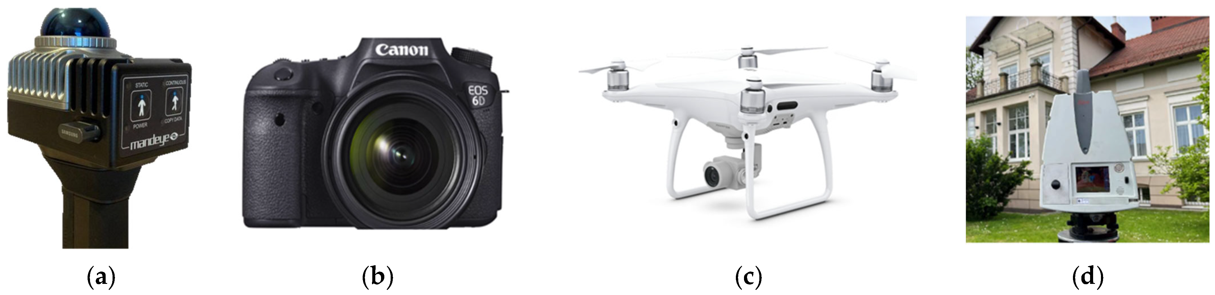
The experimentation was carried out using a multi-sensor. In particular, it was conducted using a mobile handheld laser scanner, MandEye, developed by DatCap sp. z o.o., Kraków, Poland (
Figure 2a), based on the Livox Mid-360 sensor (Livox Technology Co., Ltd., Shenzhen, China), which is a low-budget solution present on the market; this device has proven to be both highly efficient and precise, offering a reliable tool for geospatial data acquisition [
45]. The cost of this solution is approximately EUR 5000, according to the vendor’s official website (datcap.eu). Another solution employed for photographic measurements was performed using a DSLR camera with a 20.2 MP full-frame sensor and a compact design: the Canon EOS 6D, manufactured by Canon Inc., Tokyo, Japan (
Figure 2b) equipped with a Sigma Art 35 mm lens. This setup provided high-quality image data for generating 3D models and was a cost-effective choice (
www.canon.com), with an approximate price of EUR 500. Another measurement device used in the study was the Phantom 4 Pro, manufactured by DJI Technology Co., Ltd., Shenzhen, China (
Figure 2c), equipped with a built-in camera featuring a 1-inch, 20 MP CMOS sensor. The focal length is 8.8 mm/24 mm, which is equivalent to the 35 mm format, ensuring high-quality aerial imagery for photogrammetric processing (
www.dji.com). The price of this low-budget device is approximately EUR 1300.
4.3. Point Cloud from TLS
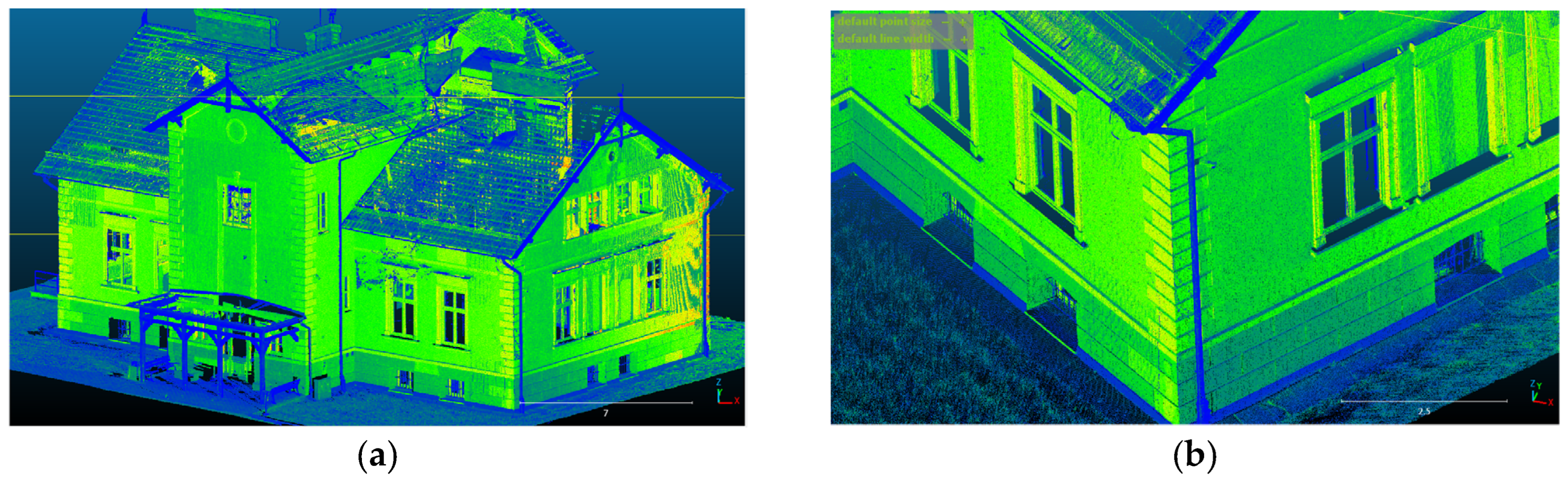
A TLS survey was carried out using a Leica ScanStation P40, manufactured by Leica Geosystems AG, Heerbrugg, Switzerland, capturing detailed 3D spatial data from six strategically placed stations to ensure full coverage, as shown in
Figure 3. Reference and spherical targets were used to improve point cloud alignment and minimize registration errors. Data was processed in Leica Cyclone CORE, achieving a high registration accuracy of 0.004 m. The low mean absolute error (0.004 m with constraints, 0.000 m without) indicates excellent alignment, ensuring the reliability of the spatial data for further analysis and modeling.
4.4. Point Cloud from SLAM
The data acquired with the handheld MandEye laser scanner were processed using open-source software provided by the manufacturer (
Figure 4). The MandEye controller software, V.1.2.3, developed by DatCap sp. z o.o., Kraków, Poland (
https://github.com/JanuszBedkowski/mandeye_controller (accessed on 10 August 2025)) was used to manage the scanner during acquisition, while the HDMapping software, v.2.0.1 developed by MapsHD, Warsaw, Poland (
https://github.com/MapsHD/HDMapping (accessed on 25 August 2025)) facilitated the processing and generation of point clouds from the mobile laser scanning (MLS) data [
46].
The MLS system based on the Livox Mid-360 sensor provides dense point clouds with centimetric accuracy under typical operating conditions. The sensor is characterized by a ranging error ≤ 0.02 m @ 10 m (down to 0.02 m @ 0.2 m) and an angular error ≤ 0.15°, with a typical output rate of approximately 200,000 points per second at 10 Hz [
45,
46]. Laboratory tests comparing the MandEye MLS system with a Leica P40 TLS reference demonstrated geometric agreement at the 10–15 mm level for cylindrical features and edges, below 10 mm for planar surfaces, and mean absolute registration errors of approximately 0.013 m in static mode and 0.017 m in dynamic acquisition. These results confirm that the MLS sensor head itself delivers stable centimetric accuracy suitable for low-cost Scan-to-BIM workflows [
45,
46].
Figure 5 shows the result of cloud-to-cloud between MLS to TLS (reference) and histogram distribution of sound values. MLS-TLS data consistency is at the level of single centimeters. In extreme cases, it is at the decimeter level, but this is for noise points and measurement heads that are not buildings.
4.5. Photogrammetric 3D Reconstruction Using SfM-MVS Software, Developed by ETH Zürich, Zürich, Switzerland
4.5.1. Integration of Terrestrial and UAV Photogrammetry
A total of 215 images were captured using the Canon EOS 6D DSLR camera and a DJI drone. The Canon EOS 6D was used to acquire 86 high-resolution images, configured with an aperture of f/7.1, 1/160 s exposure, ISO 320, and a 35 mm focal length. The UAV-based DJI FC6310 camera captured 46 aerial images with a 9 mm lens (24 mm equivalent), f/2.8 aperture, ISO 120, and 1/1000 s exposure, ensuring sharp imagery suitable for photogrammetric processing and 3D reconstruction.
4.5.2. Point Cloud Using COLMAP Software
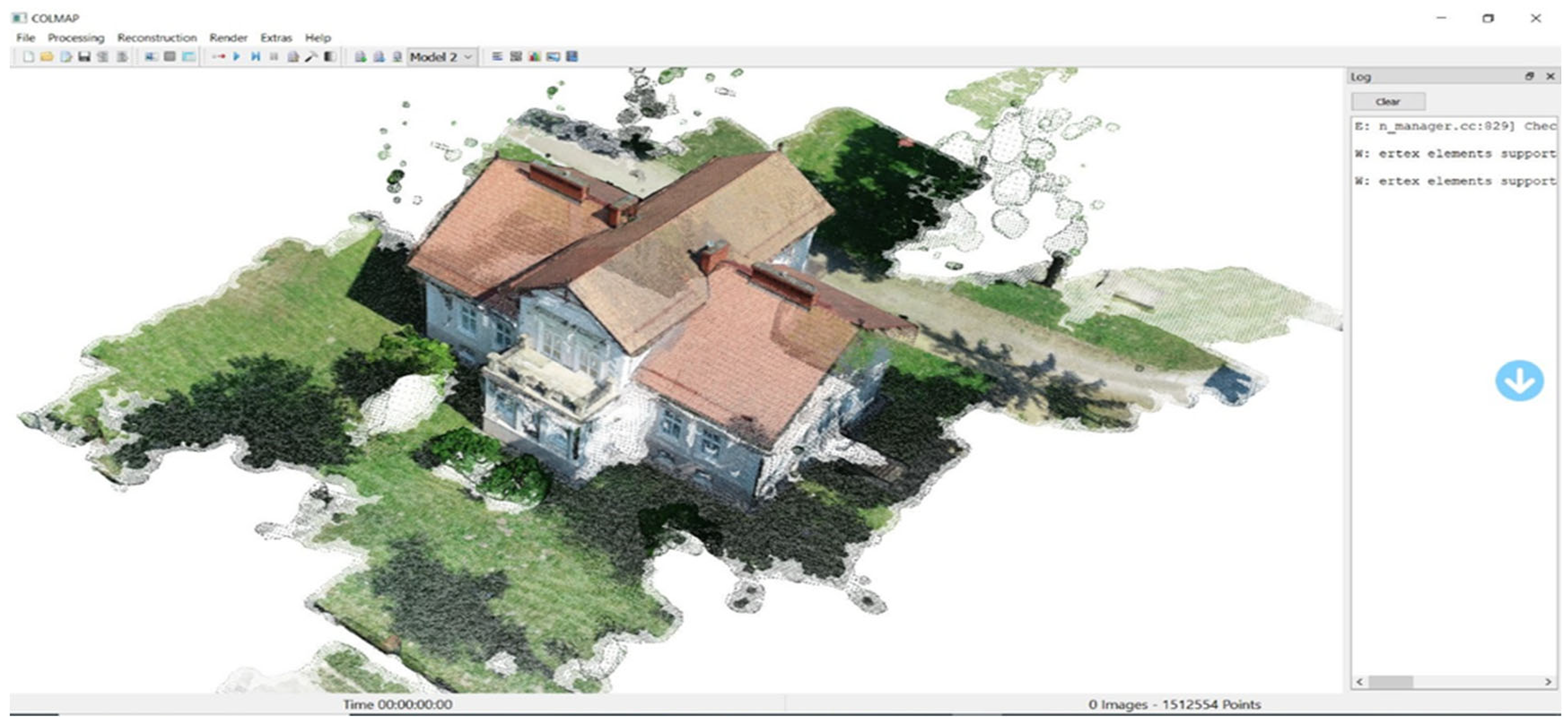
The 3D reconstruction OS software used in this research was COLMAP, v.3.14.0, developed by ETH Zürich, Zürich, Switzerland. The process began with the systematic acquisition of high-resolution overlapping photographs using a calibrated digital camera and UAV, commonly known as a drone camera. Images were captured at consistent intervals and multiple angles to ensure full spatial coverage, with at least 60% overlap between adjacent views to facilitate robust image alignment and reconstruction. The photogrammetric pipeline commenced with feature extraction, wherein distinctive key points were detected and described using the SIFT algorithm. The camera model was defined as SIMPLE_RADIAL, and focal length values were automatically extracted from embedded EXIF metadata. With correspondences established, SfM reconstruction was carried out using COLMAP’s incremental mapper. The process involved estimating camera parameters and generating a sparse 3D point cloud using SfM with bundle adjustment to enhance accuracy. Image undistortion was applied, followed by dense depth map generation using PatchMatch Stereo with geometric consistency to handle low-texture areas and occlusions. Depth maps were fused via COLMAP’s stereo fusion, requiring at least three consistent observations per point to ensure reliability. The final high-density point cloud preserved fine architectural details and surface features critical for heritage assessment and AEC applications, as shown in
Figure 6.
The final dense point cloud was exported in (.PLY) format and imported into CloudCompare, where it underwent further post-processing. Indeed, noise was reduced using statistical outlier removal filters to eliminate erroneous points from occlusions or mismatches, improving dataset clarity and structural integrity. The model was then visually inspected and manually cleaned to remove unwanted elements like terrain, vegetation, or scaffolding.
4.5.3. Point Cloud Obtained in Agisoft Metashape Software
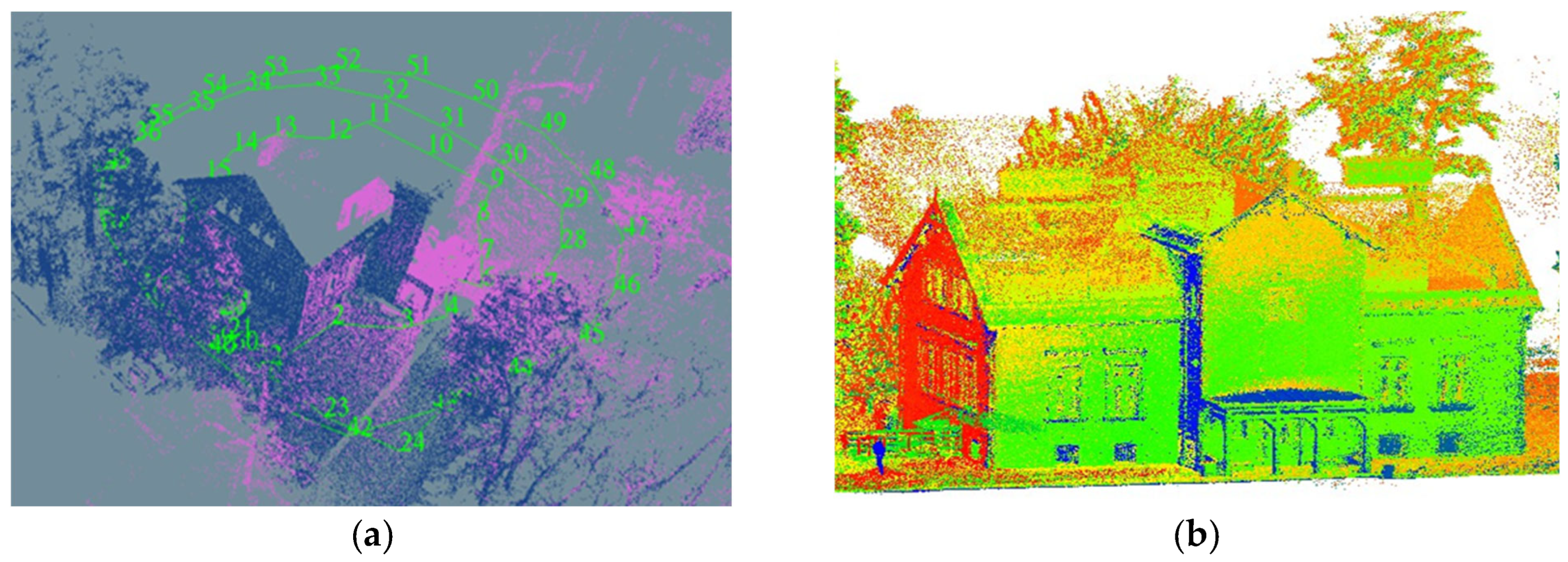
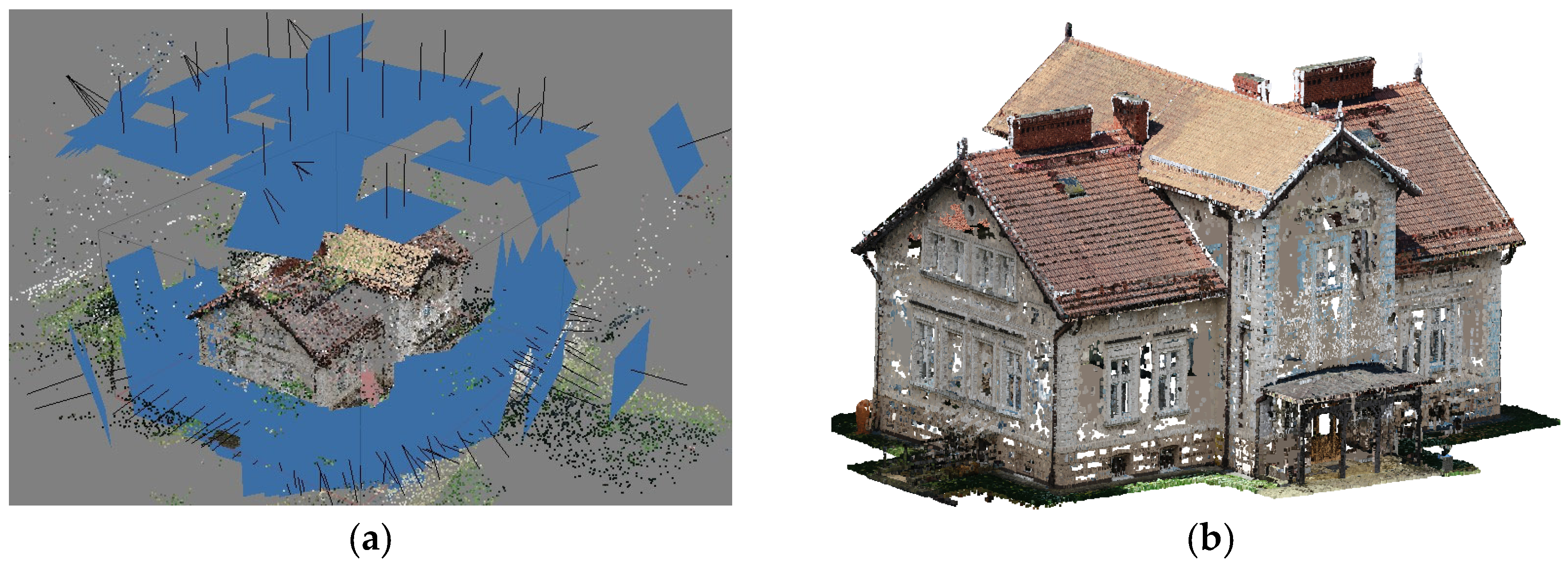
All images were captured ensuring sufficient redundancy for robust image alignment and 3D reconstruction using Agisoft Metashape, v 2.3.0, developed by Agisoft LLC, St. Petersburg, Russia, a widespread commercial software. The processing workflow began with the “Align Photos” function, which detects common features to estimate camera positions and generate a sparse point cloud
Figure 7a. This was followed by the “Build Dense Cloud” step, where MVS algorithms calculated depth information across multiple views to create a detailed 3D model. The resulting dense point cloud was then cleaned using built-in tools to remove noise and outliers. Optional steps such as mesh generation and texture mapping were performed to prepare the data for further use in line with the defined BIM use case, as shown in
Figure 7b. Processing parameters, such as alignment accuracy and depth filtering, were adjusted to optimize the balance between model quality and computational performance. The photogrammetric processing performed using Agisoft Metashape resulted in the generation of a dense point cloud covering the entire building. The processing accuracy, evaluated based on control points, reached approximately 3 cm in planimetric accuracy, with maximum spatial errors of up to 7 cm. Additionally, the use of scale bars for independent metric verification showed that the mean geometric accuracy of the point cloud relative to the real object was approximately 3 cm. These results indicate that the commercial photogrammetric workflow provides stable centimetric accuracy suitable for Scan-to-BIM applications.
In this research, Agisoft Metashape was used solely to evaluate the point cloud generated by the open-source software COLMAP, as the study aims to complete the full 3D reconstruction workflow using low-cost and freely available tools.
4.6. Conceptual BIM Modeling: Revit vs. Open-Source Tools
4.6.1. Modeling in Autodesk Revit
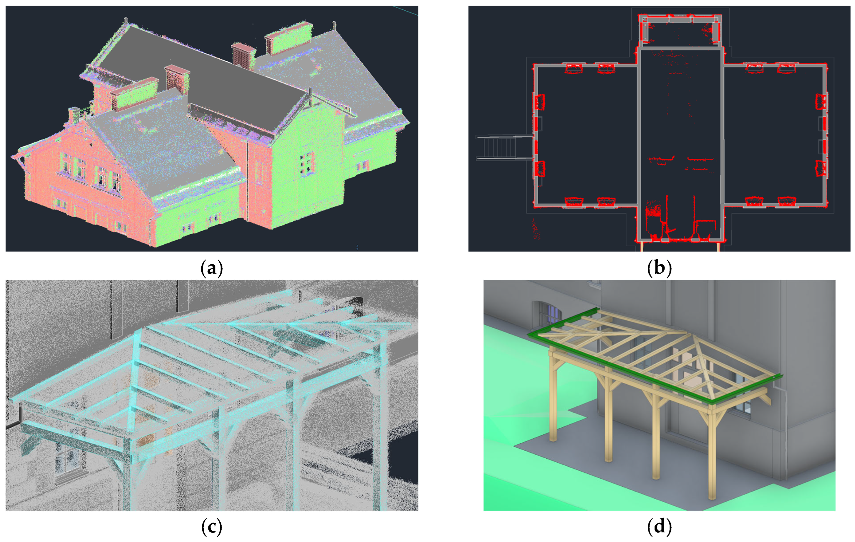
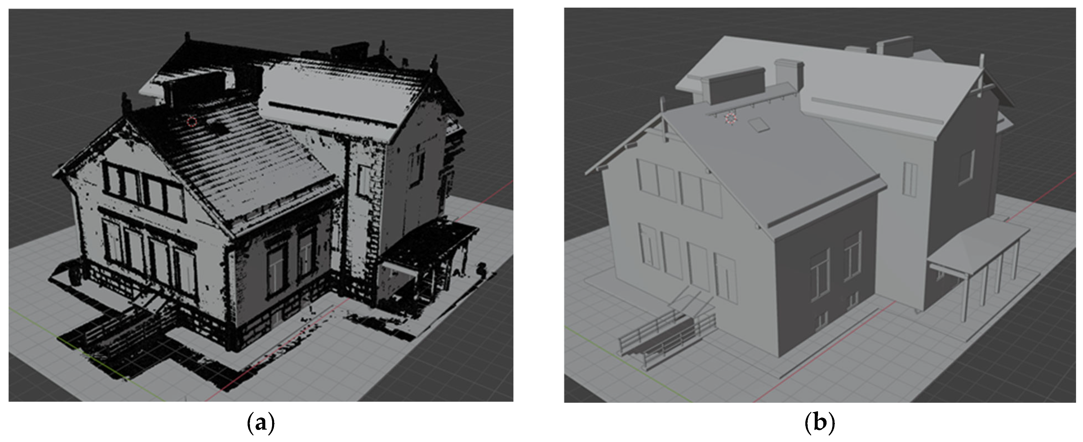
As already mentioned, Autodesk Revit, developed by Autodesk, Inc., San Francisco, CA, USA, represents an industry standard and is widely adopted in the AEC industry due to its advanced parametric modeling, built-in libraries, and strong integration with other Autodesk tools. The applied process involved the point cloud import (in .rcp format), manual alignment, and semi-automatic creation of architectural elements such as walls, floors, and roofs. Revit’s Snapping tools and Revit Families allowed for efficient object placement. However, the software required a licensed version, and its customization options were limited to the Revit API. To ensure consistent conditions for evaluating different data acquisition methods, two separate conceptual BIM models were developed in Autodesk Revit, both using the same software environment but based on different types of input data. The first model was created using a point cloud generated from MLS. This dataset provided high-density 3D geometry, especially suitable for capturing interior spaces and structural elements in detail, as shown in
Figure 8.
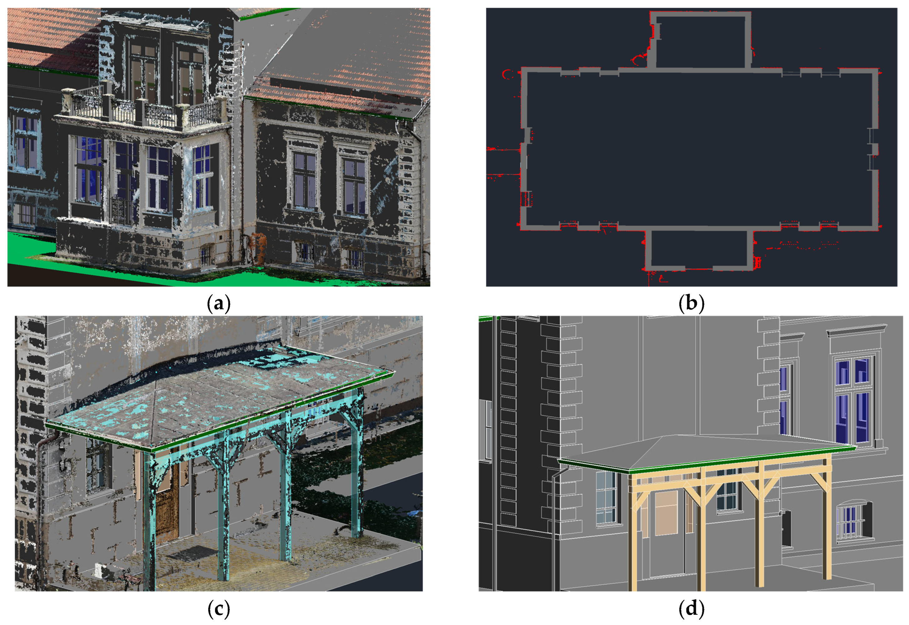
The second model was built from a photogrammetric point cloud. This dataset offered broader coverage and rich texture information, particularly useful for reconstructing roofs, façades, and external architectural features, as shown in
Figure 9.
Both datasets were imported into Revit as *.rcp files via Autodesk ReCap, developed by Autodesk, Inc., San Francisco, CA, USA. Using Revit’s native modeling tools, walls, floors, and other architectural components were manually reconstructed based on each point cloud. This approach allowed a direct comparison of data source quality and suitability within the same conceptual BIM modeling environment, isolating the impact of input data rather than software differences.
4.6.2. Modeling in BlenderBIM
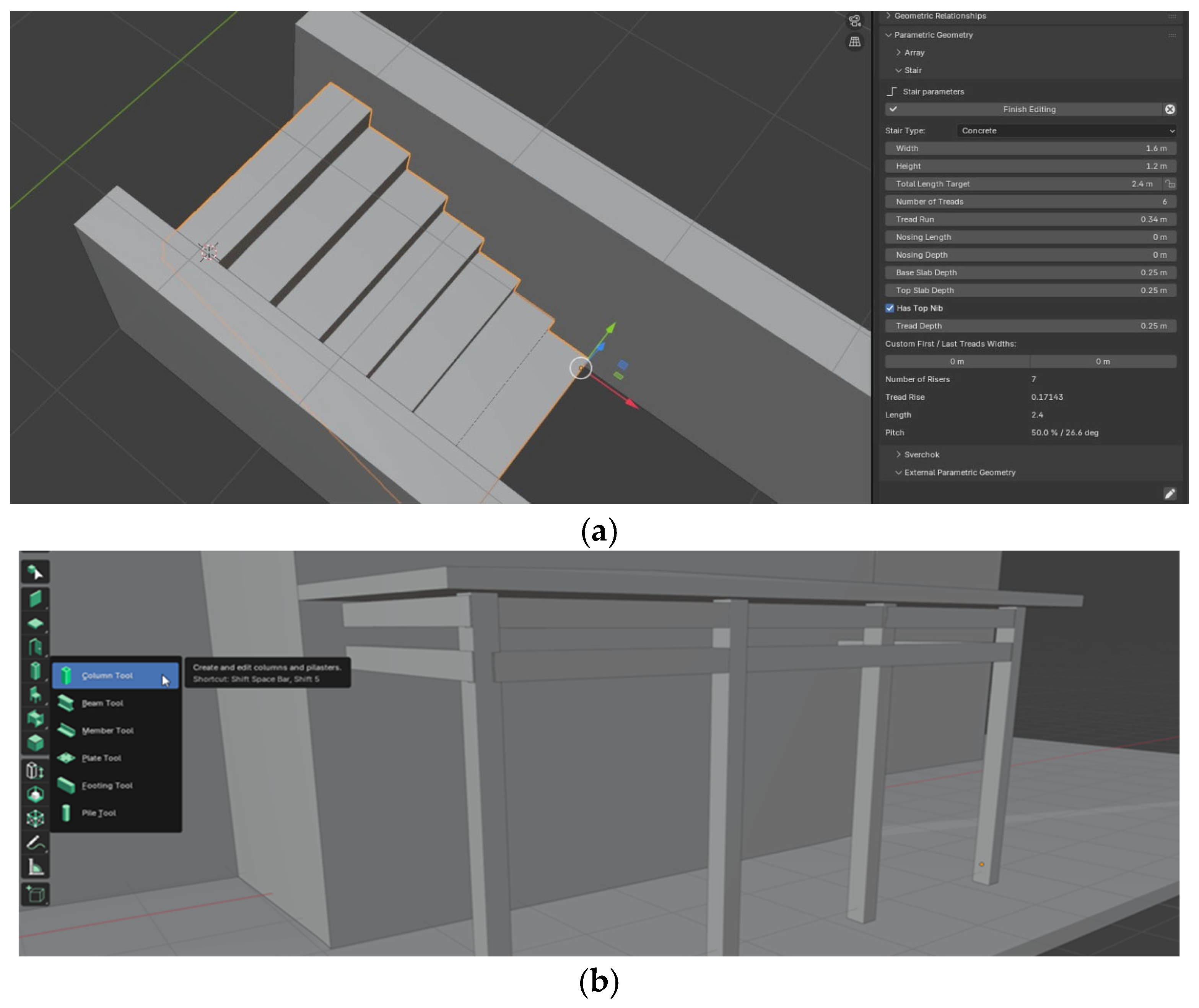
OSS and development environments were used as alternatives to commercial BIM tools, with Blender, developed by the Blender Foundation, Amsterdam, The Netherlands, and the BlenderBIM add-on, developed by IfcOpenShell Ltd., London, UK, employed for 3D modeling. BlenderBIM, built on IfcOpenShell, developed by IfcOpenShell Ltd., London, UK, enables the reading, creation, and editing of IFC models, managing BIM data, generating technical visualization-oriented documentation, and performing basic analyses, quantity take-offs, cost estimation, and scheduling. Using SLAM- and photogrammetry-derived point clouds, modeling combined geometric data with semantic information from site inspections, asset knowledge, and archival imagery. Structural elements such as walls, columns, stairs, roof, windows, and doors were fitted to the point cloud, capturing both 3D geometry and rich asset information through object families, types, and material and technical properties (
Figure 10).
Another method for generating objects, widely used in BIM environments, is parametric modeling, in which individual elements are created by assigning values to predefined attributes, as shown in
Figure 11.
Attributes such as dimensions, material properties, and functional roles govern an object’s behavior and relationships within a digital model. By defining geometry alongside family, type, and semantic descriptors, the model becomes a structured information system. Standardization through classification and data-dictionary systems (particularly the bSDD, as well as Uniclass, OmniClass, and MasterFormat) ensures interoperable, machine-readable data, linking BIM objects to recognized definitions for consistent meaning across disciplines and software. These frameworks organize elements hierarchically by function, composition, or lifecycle, supporting the integration of diverse datasets and structured visualization-oriented documentation, which is critical in cultural heritage applications.
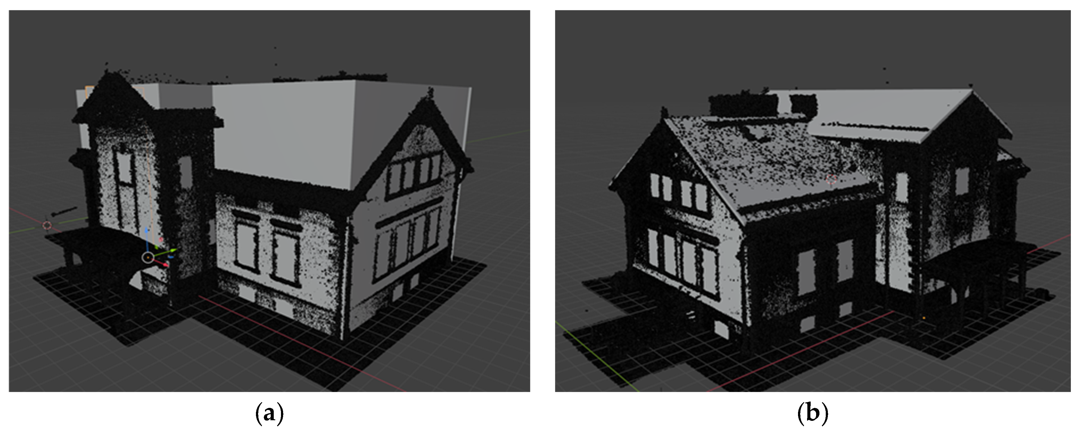
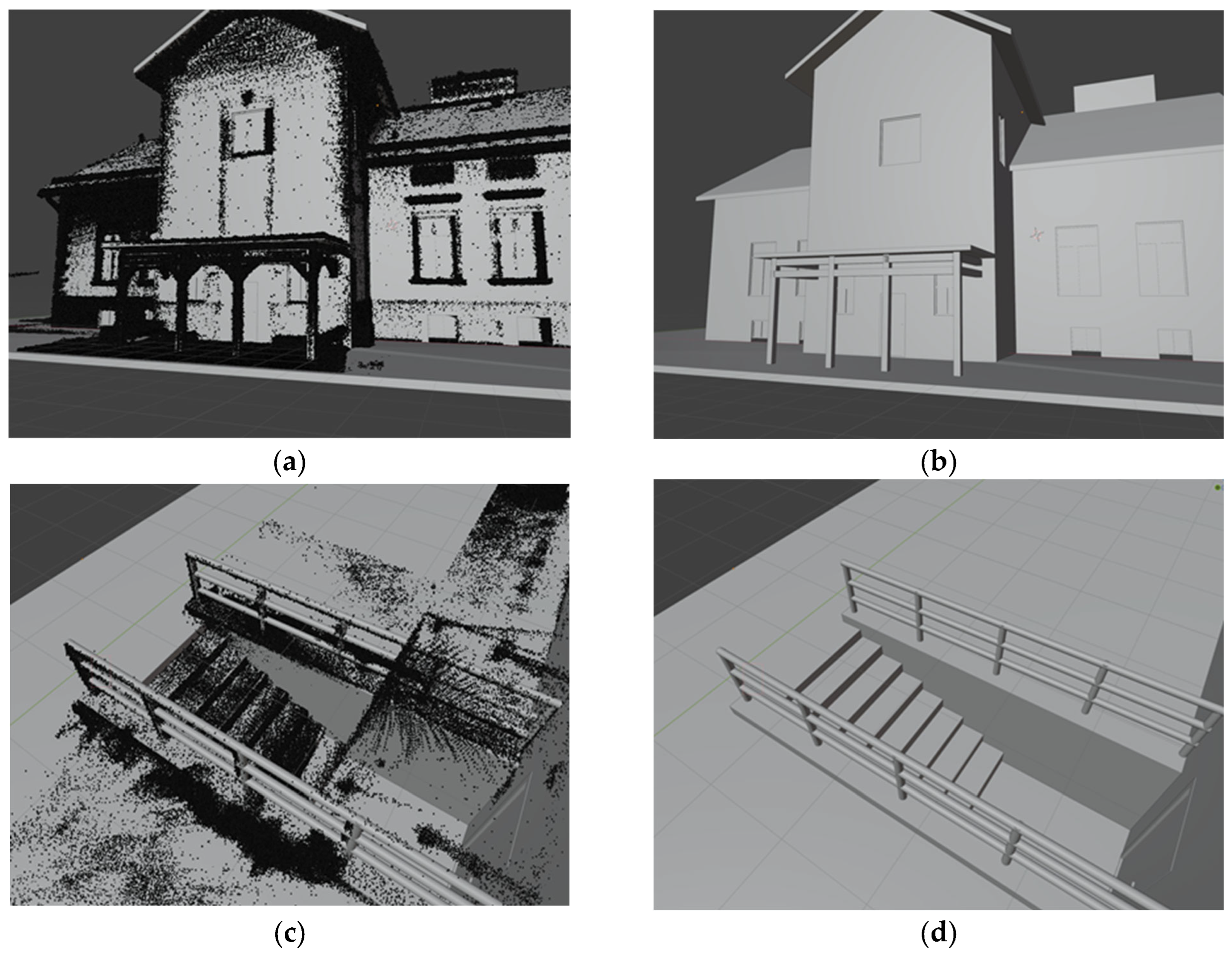
Low-budget acquisition using SLAM and UAV photogrammetry generated two-point clouds with widely available tools, providing reliable, comprehensive data for conceptual BIM modeling (
Figure 12). Similarly, a BIM-compliant model was generated from the photogrammetry-derived point cloud (
Figure 13).
Another critical aspect of conceptual BIM models is their interoperability, and the ability to transition between different software environments, including tools for technical visualization-oriented documentation, presentation, and visualization without loss of critical information. In addition to BIMVision V.2.25.3, developed by Datacomp IT Sp. z o.o., Kraków, Poland, which is also available free of charge, TwinMotion V.2025.1, developed by Epic Games, Inc., Cary, NC, USA (
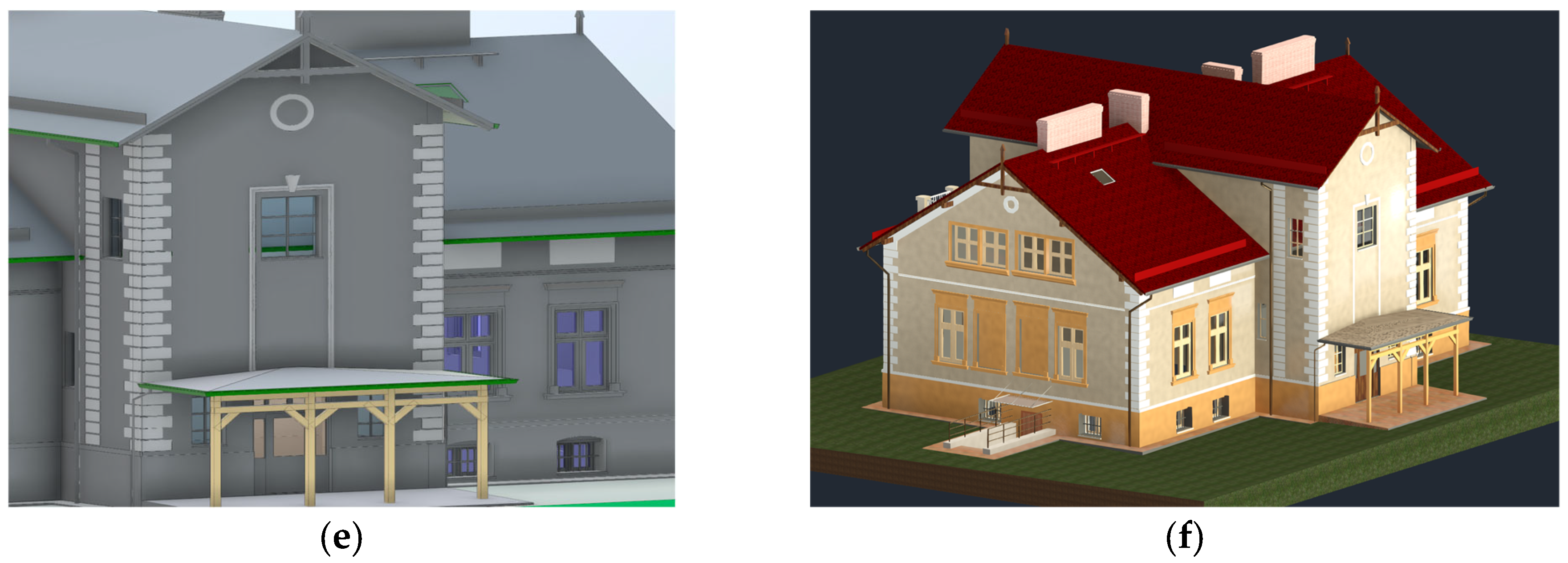
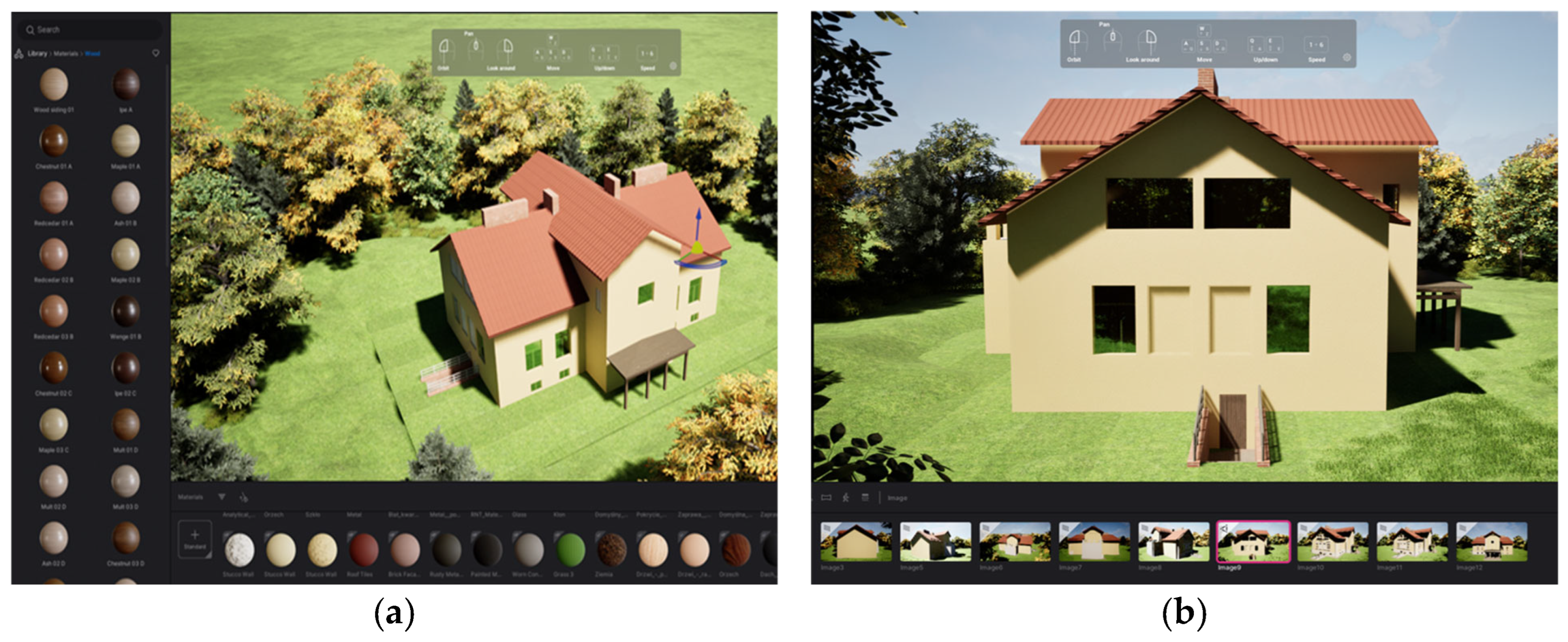
https://www.twinmotion.com/en-US) was employed in the study as a visualization platform. Subsequently, based on the identified families, types, and object information, these attributes were reconstructed and encoded in the conceptual BIM model. Visualizations of conceptual BIM models derived from point clouds were rendered using open-source software, as shown in
Figure 14.
5. Results
5.1. Point Cloud Quality and BIM Mapping Applications
This section presents the outcomes of the data acquisition, 3D reconstruction, and BIM visualization processes conducted in this study. The results focus on evaluating the accuracy and quality of the photogrammetric point clouds generated using different image sources and software solutions, as well as assessing their integration into BIM workflows. Comparative analyses were performed between photogrammetric models and a highly accurate TLS reference dataset to quantify geometric precision. The following subsections detail the findings related to the quality assessment of the point clouds and the role of BIM mapping in enhancing model usability and visualization.
5.2. Quality of the Point Cloud Generated in OS Environment
To evaluate the deviations between the photogrammetry-derived point cloud and the reference dataset obtained from TLS, the cloud-to-cloud (C2C) distance computation tool was employed in CloudCompare [
47]. This method is widely used to assess the geometric differences between two 3D point clouds and is particularly useful in quantifying noise or registration accuracy in spatial data [
48]. It is computed for each point in the compared cloud by measuring its distance to the nearest point in the reference cloud. The C2C distance tool calculates the distance between two point clouds by computing the nearest neighbor distance from each point in the compared cloud (often the “source” or “data”) to the reference cloud (often the “target” or “ground truth”). For each point P
i in the compared cloud C
1, the C2C distance d
i is computed as shown in Equation (1):
where
- -
Pi is a point in the compared cloud C1.
- -
Qj is a point in the reference cloud C2.
- -
||Pi − Qj|| is the Euclidean distance between the two points.
The result is a scalar distance for each point in C1, indicating how close it is to the nearest point in C2. These distances can be visualized as a color map in CloudCompare to highlight areas of deviation.
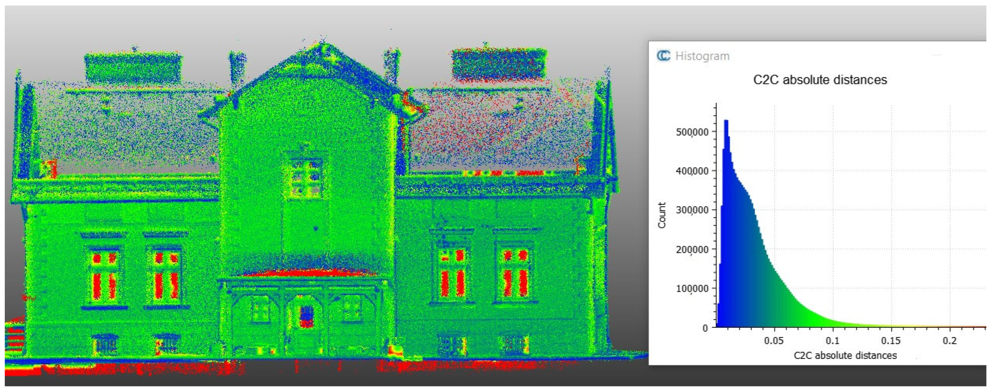
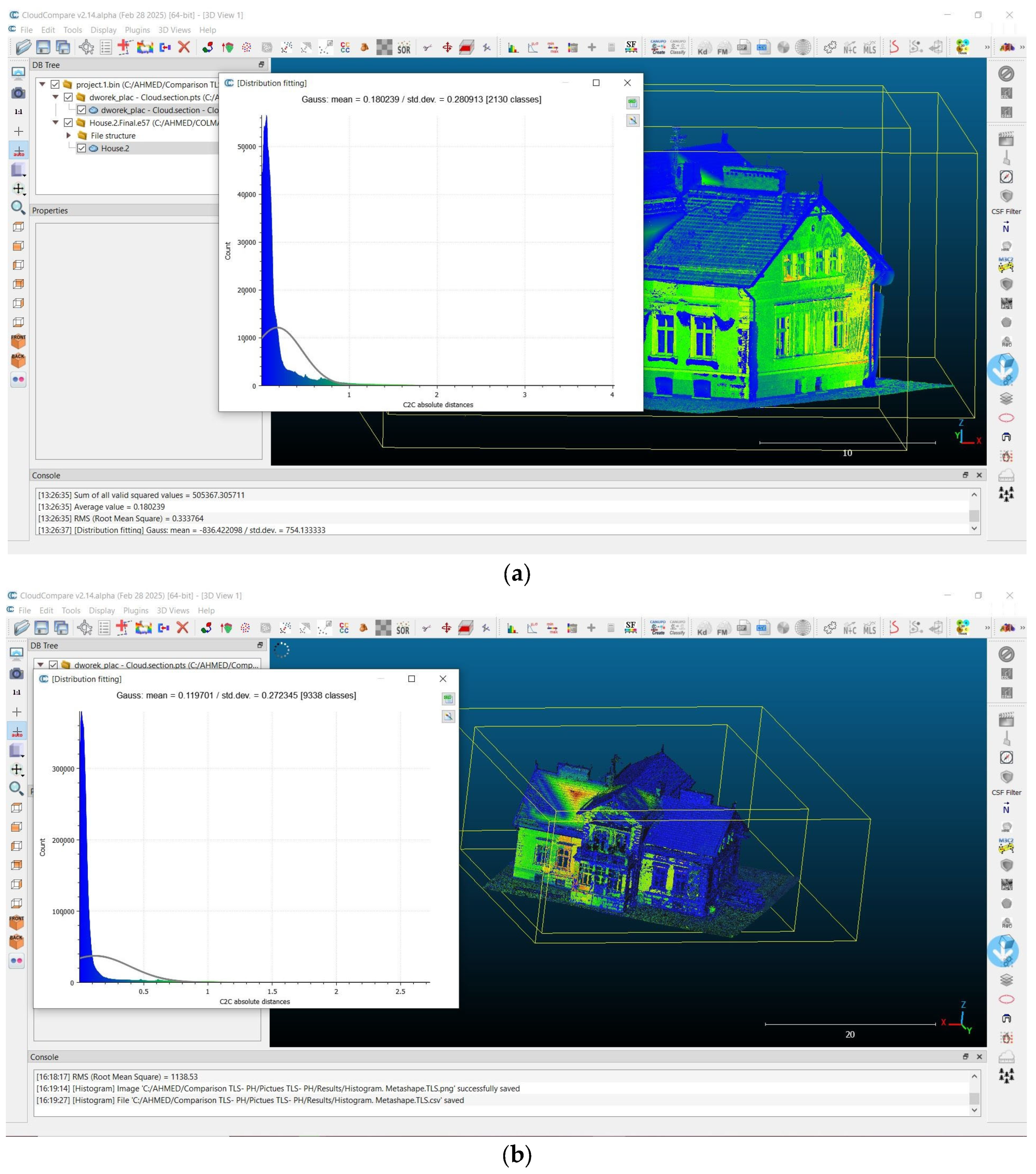
In this environment, the COLMAP point cloud was compared to a highly accurate TLS reference from a Leica Scanstation P40, which had a very low registration error of 0.004 m. Cloud-to-cloud comparisons showed differences between the photogrammetric and TLS point clouds. The COLMAP software-generated (
Figure 15a) point cloud exhibited a mean deviation of 0.1802 m with a standard deviation of 0.2809 m when compared to TLS, indicating reasonable, but less precise, alignment. In contrast, the Metashape software-derived (
Figure 15b) point cloud showed improved accuracy with a lower mean deviation of 0.1197 m and a standard deviation of 0.27234 m against the TLS data.
This suggests that Metashape’s photogrammetric pipeline may provide better point cloud quality or denser reconstruction in this context.
The observed mean deviations between the photogrammetry-derived point clouds and the TLS reference dataset indicate the expected geometric fidelity achievable with low-cost sensors and open-source processing pipelines. Specifically, the COLMAP point cloud exhibited a mean deviation of approximately 18 cm, whereas the Metashape dense reconstruction achieved around 12 cm. These results reflect the trade-off between accessibility, affordability, and geometric precision. When evaluated against the predefined Level of Information Need (LIN), these deviation values are sufficient for visualization-oriented documentation, conceptual BIM, and early-stage heritage documentation, where decimetric accuracy (approximately 0.12–0.18 m deviation) is acceptable. However, they do not meet the stricter tolerances required for structural analysis or conservation-grade modeling.
5.3. BIM Mapping Helps
The selected low-budget solutions align perfectly with the objectives and scope of this research by providing an affordable yet effective means of acquiring high-quality spatial data. The use of cost-efficient SLAM-based laser scanning, close-range photogrammetry, and UAV imaging enables comprehensive and detailed 3D visualization-oriented documentation while minimizing financial constraints.
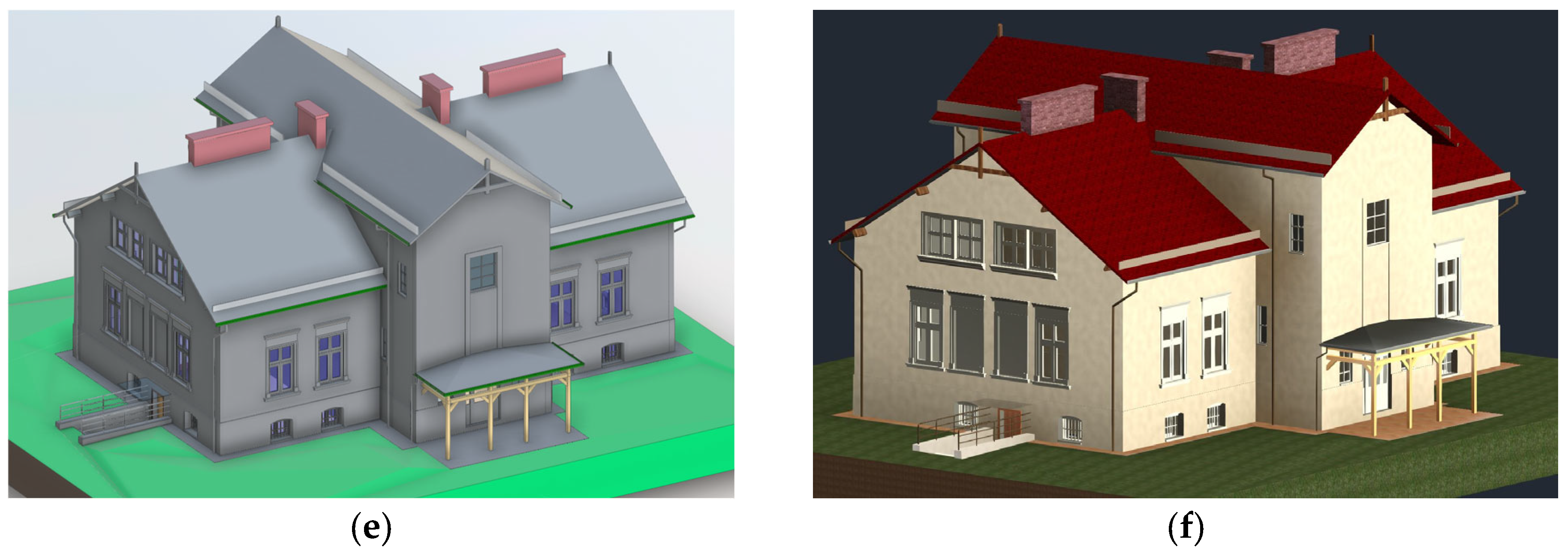
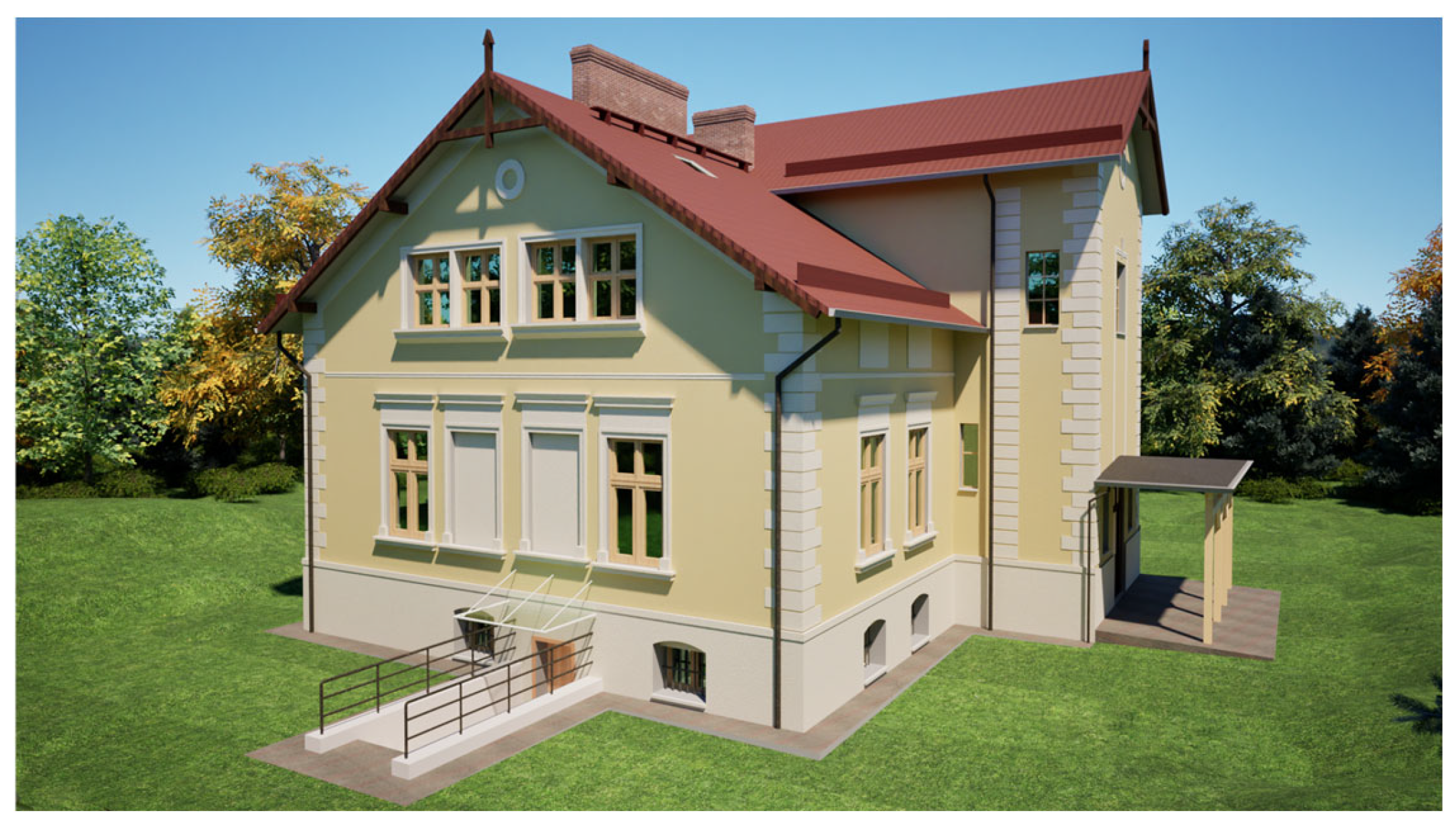
These technologies allow the efficient generation of point clouds for BIM-ready models without the need for expensive, high-end equipment, making them accessible for broader applications in the AEC industry. Furthermore, their portability and ease of use facilitate rapid data collection in diverse environments, ensuring flexibility and adaptability in various tasks. Based on the developed BIM-ready models and high-resolution UAV imagery, realistic materials and textures were applied to the reconstructed 3D geometry. Photographs captured during the aerial survey were used to define surface characteristics, such as wall colors, roofing materials, and window reflections. The textured model enabled the generation of photo-realistic visualizations and renderings of the building, enhancing its presentation and interpretability using the BlenderBIM add-on and TwinMotion (
Figure 16).
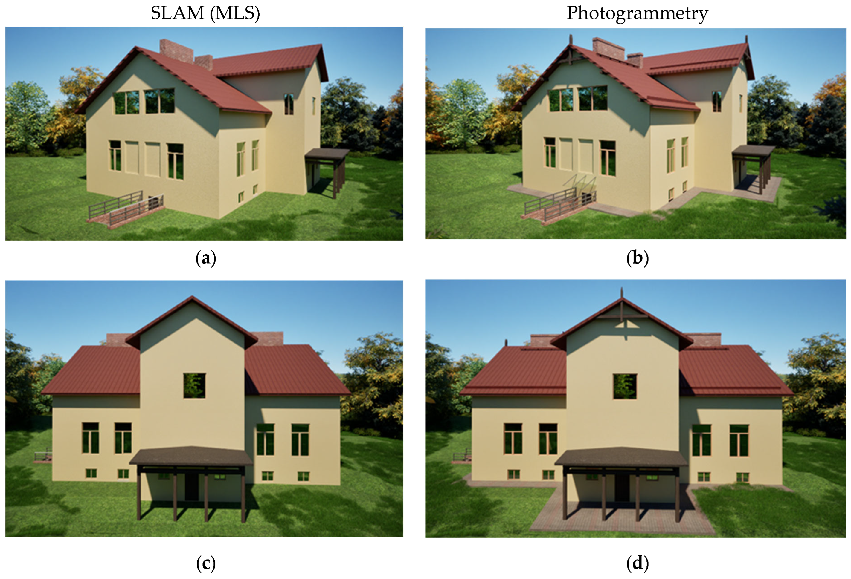
Figure 17 illustrates the conceptual BIM model visualized in TwinMotion, showing an isometric view generated from (a) SLAM data and (b) photogrammetry data, alongside the front elevation view derived from (c) SLAM data and (d) photogrammetry data.
To facilitate a clear and consolidated comparison of the investigated data acquisition approaches,
Table 3 summarizes the main quantitative results obtained in this study. The table reports, for each dataset (TLS, SLAM-based mobile laser scanning, open-source photogrammetry, and commercial photogrammetry), the deviation values with respect to the TLS reference, the achieved accuracy level, and the main practical advantages and limitations observed during processing and BIM integration. This comparative overview supports the interpretation of the results by highlighting the trade-offs between accuracy, cost, and operational efficiency, and by clarifying the suitability of each approach for different Scan-to-BIM use cases in relation to the defined Level of Information Need.
6. Discussion
6.1. Workflow Applied to the Case Study
These outcomes provide the foundation for a broader discussion articulated in the following subsections. First, the “Generation of Point Clouds Using Open-Source Software” subsection assesses the capability of non-commercial platforms to produce dense, reliable spatial datasets and evaluates their suitability for downstream BIM tasks. This is followed by the “Comparison of Revit conceptual BIM Models Derived from MLS and Photogrammetry Data” subsection, which examines differences in geometric accuracy, modeling consistency, and workflow efficiency across the two acquisition methods. Lastly, the “Critical Analysis of the Use of Open-Source Software” subsection reflects on the benefits, challenges, and current limitations associated with adopting open-source environments within AEC and BIM processes, offering insights into their practical implications and future development trajectories.
6.2. Generation of Point Cloud in OS Software
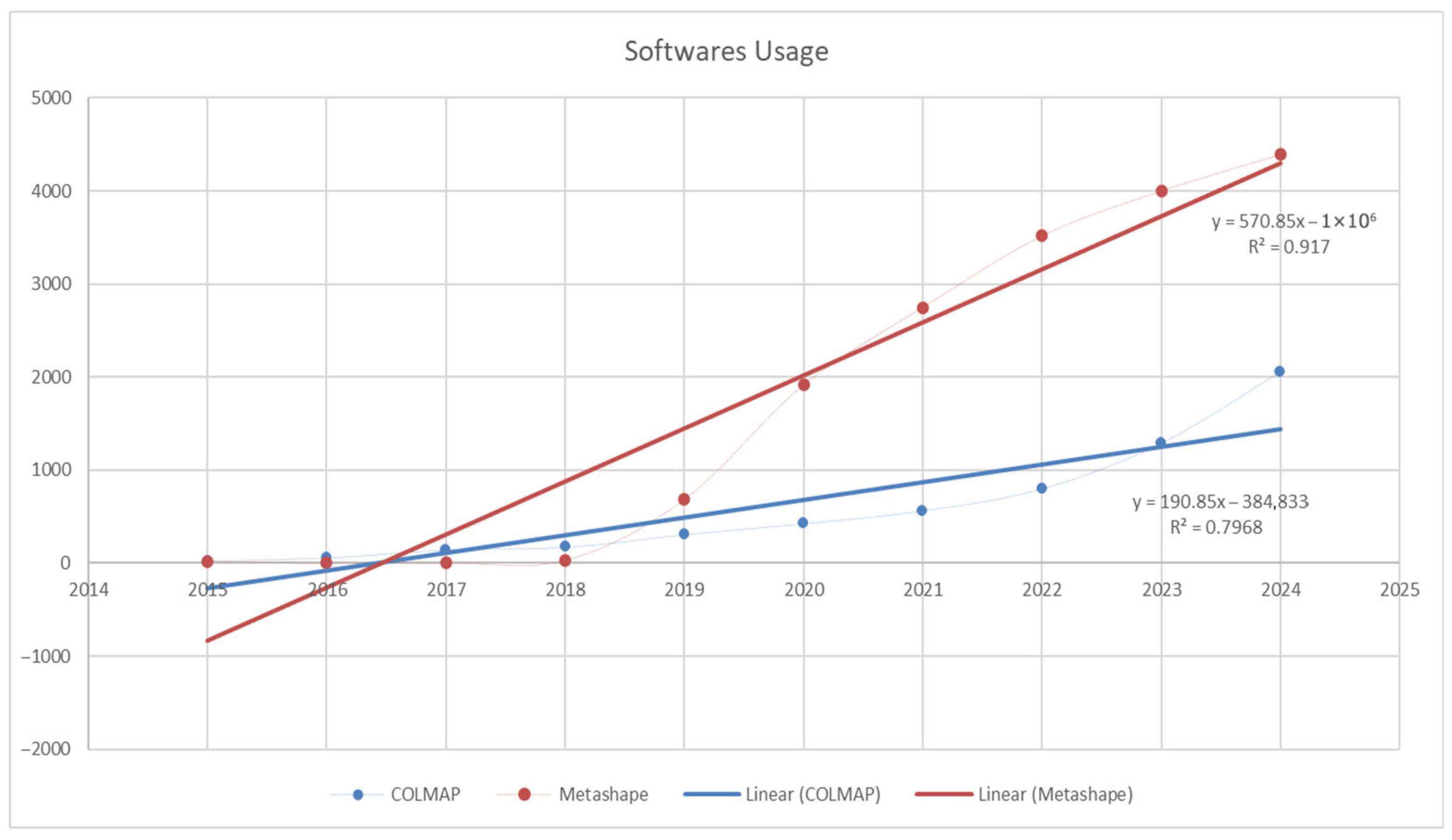
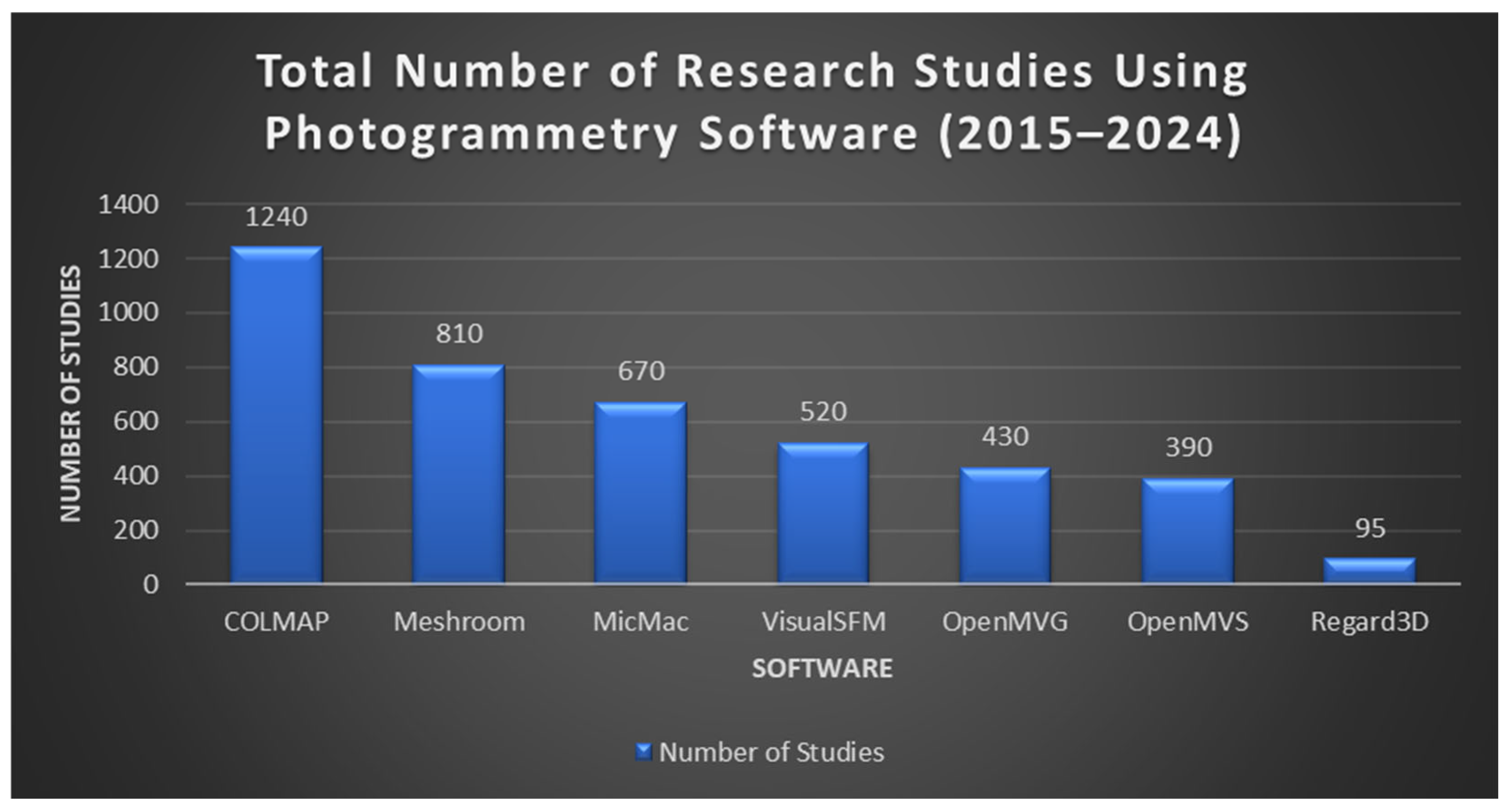
In recent years, the adoption of open-source photogrammetry software has significantly expanded within the AEC field, as well as in cultural heritage visualization-oriented documentation and environmental surveying. The increasing availability of low-cost sensors and community-driven software development has made 3D reconstruction workflows more accessible and customizable, promoting transparency and reproducibility in research. To better understand this evolution, a trend analysis was carried out based on scientific databases reporting studies focused on the generation of 3D point clouds using open-source solutions. In particular, the research was performed taking into consideration the major photogrammetry tools in the range from 2015 to 2024. Drawing on data from Scopus and Google Scholar, it examines their adoption trends, research applications, and key strengths and limitations within scholarly workflows, as shown in
Figure 18.
This highlights the trade-off between the affordability of open-source tools and the higher automation of commercial software [
49]. A bibliometric analysis of COLMAP and Metashape publications from 2015–2024, using Google Scholar, tracked active software usage. Metashape grew rapidly, peaking at over 4000 publications in 2024 (R
2 = 0.6694), then slightly declined in 2025. COLMAP, by contrast, showed steady growth, reaching over 2000 publications in 2024 with a stronger linear trend (R
2 = 0.7694), reflecting rising interest in open-source, customizable photogrammetry solutions (
Figure 19).
The reported deviations (~12–18 cm) have direct implications for the intended BIM applications. For 3D visualization and dissemination, these deviations are within acceptable limits, allowing the accurate representation of overall building morphology and key architectural elements. For conceptual BIM or volumetric visualization-oriented documentation, the deviations are also consistent with ISO 7817:2024-defined Levels of Information Need, ensuring that the resulting models can support early-stage design decisions and heritage asset assessments. Nevertheless, applications requiring high geometric precision would require TLS or higher-end commercial photogrammetry to meet stricter accuracy thresholds. These observations highlight the importance of aligning the chosen data acquisition method with the specific Level of Information Need for each Scan-to-BIM use case.
6.3. Comparison of Revit Conceptual BIM Models from MLS and Photogrammetry Data
Autodesk Revit v. 2025 is one of the most widely used BIM platforms in the world, offering advanced parametric modeling capabilities, extensive object libraries (Revit Families), and seamless compatibility with various point cloud data formats. In this study, two models were created in Revit under identical conditions, using point clouds obtained from handheld MLS scanning (MandEye) and photogrammetry. Both input datasets were imported into Revit as linked RCP files. Using Revit Families, architectural and structural elements (such as walls, slabs, openings, and roof geometry) were reconstructed. The MLS-derived BIM-ready model achieved approximately 10 cm global accuracy and ~2 cm local precision, sufficient for accurately modeling overall building volumes, structural alignments, and main elements. The UAV-based photogrammetry dataset (UAV + close-range photogrammetry) delivered ~3–4 cm accuracy, with significantly improved detail and RGB texture. The colored point cloud enabled easier identification of façade features (cornices, window frames, and decorative elements) that were difficult to distinguish in the MLS model. As a result, the Revit model based on the UAV photogrammetry captured complex architectural details and surface textures, enabling a higher geometric precision and data accuracy, with enhanced semantic richness. The MLS-based model proved suitable for volumetric representation and essential structural visualization-oriented documentation, while the photogrammetry model allowed more refined façade modeling and improved visual realism (all within the same Revit environment).
6.4. Critical Analysis About the Use of OS Software
Parametric 3D modeling from point clouds, whether derived from SLAM or photogrammetry, was assessed in open-source environments for workflow efficiency, geometric fidelity, and parameterization. While geometry can be accurately reproduced, precision is generally lower, and interactive manipulation of active point clouds is less fluid than in commercial software. Editing relationships between elements, such as openings and components, often requires manual adjustments.
Open-source tools enable the creation of parametric elements with clear parameters, supporting regular structures like stair runs, though direct editing of families or base geometry may be limited and require workarounds. Commercial software provides more advanced family/type editing, allowing higher detail and easier modification of complex relationships.
In terms of interoperability, open-source platforms support standard data exchange (IFC) and model import/export, but multi-user collaboration is often constrained or relies on additional tools. Commercial solutions offer broader integration, richer exchange formats, and smoother multi-disciplinary coordination. Material assignment and visualization are possible in open-source software, though advanced texturing and rendering are more fully developed in commercial systems.
Overall, open-source tools like BlenderBIM can produce reliable BIM-ready models with moderate precision, especially for regularly structured elements, while commercial platforms remain advantageous for high-detail modeling, automation, complex family editing, and collaborative workflows. Choice of software should balance desired detail, available resources, and coordination needs.
7. Conclusions
This research highlights the pivotal role of open-source software in democratizing visualization-oriented digital documentation and BIM processes, particularly for academic institutions and small enterprises with limited access to commercial tools. By lowering financial and technical barriers, open-source platforms enhance digital literacy, foster innovation, and support the broader digital transformation of the AEC sector. Recent studies further confirm this trend, showing how open-source BIM ecosystems underpin new scan-to-BIM workflows and standards-compliant digital construction platforms, making advanced BIM-based processes more accessible and interoperable for the construction industry as a whole [
50,
51].
The results of this study demonstrate that open-source software combined with low-cost sensing technologies can support effective Scan-to-BIM workflows for visualization-oriented documentation and conceptual BIM applications. However, the findings are most directly applicable to buildings of similar scale, geometry, and complexity to the presented case study. Applications requiring higher geometric precision, such as conservation-grade HBIM or structural analysis, continue to benefit from terrestrial laser scanning and commercial software solutions. The proposed workflow should, therefore, be regarded as a complementary, rather than substitutive, approach within the broader Scan-to-BIM ecosystem.
A cost-effective Scan-to-BIM workflow integrating low-cost hardware with open-source software was developed and validated, demonstrating that photogrammetry and SLAM-based techniques can produce accurate and usable point clouds when verified against high-precision TLS data. COLMAP proved practical for low-budget applications, though commercial tools like Metashape remain preferable for high-accuracy needs.
While open-source solutions provide accessibility and functionality, they may be limited in precision, stability, and quality control, whereas commercial software offers automated, reliable workflows at higher cost. Nonetheless, adoption trends indicate a growing shift toward open-source platforms such as COLMAP and CloudCompare in research.
Though the proposed low-cost, open-source Scan-to-BIM workflow demonstrated reliable results for the case study presented, these findings should not be generalized to all building types or scales. The workflow is most directly applicable to buildings of moderate scale and architectural complexity, similar to the studied historic manor. Applications requiring higher geometric precision, such as detailed conservation, structural analysis, or high-fidelity HBIM, remain better served by terrestrial laser scanning (TLS) or commercial photogrammetry and BIM software. This cautious framing ensures that the suitability of the workflow is aligned with the intended Level of Information Need and the specific use case.
Integrating open-source workflows with emerging technologies, cloud computing, AI, and GIS offers promising avenues for improving accessibility, automation, and scalability. Compliant with openBIM standards, these tools create interoperable ecosystems for building inventory, facility management, and heritage conservation, and hybrid approaches combining free and commercial software can optimize precision, collaboration, and sustainable digital transformation.




 ,
,