


Simple Summary
Coastline areas are important nesting sites for ground-nesting shorebirds called plovers. However, these birds face increasing threats from human activities such as walking, cycling, and construction near their nests. We studied two plover species, the Kentish Plover and the Little Ringed Plover, over six years (2020–2025) at a popular urban waterfront on the Mediterranean coast in Algiers, Algeria. The high visitor numbers at this park up to 200,000 people on summer weekends created intense pressure on nesting birds during the breeding season. During the COVID-19 pandemic in 2020 and 2021, when the park was closed or had very few visitors, both species bred successfully with 55 nests producing chicks. Following the return of human activity, nesting success collapsed. In 2022 and 2023, not a single nest succeeded, coinciding with increased disturbance from people and construction work. Using satellite images, we also found that more than 80% of the habitat became unsuitable for nesting over this period. Our findings suggest that human activities are the primary factor limiting breeding success, through combined effects of direct disturbance and habitat degradation. Simple management actions such as seasonal restrictions and protective fencing during the breeding season could help these birds reproduce successfully while still allowing public access outside nesting periods.
Abstract
Ground-nesting shorebirds face growing pressure from recreational activities in coastal urban areas. We monitored the breeding success of Kentish Plover (Charadrius alexandrinus) and Little Ringed Plover (Charadrius dubius) over six consecutive years (2020–2025) at the Promenade of Sablettes, a heavily visited waterfront in Algiers, Algeria. We combined field surveys with multi-sensor remote sensing analysis using Sentinel-1, Sentinel-2, and Dynamic World data to quantify habitat change. A total of 105 nests were recorded across both species. Breeding success reached 70% during the COVID-19 lockdown period (2020–2021), when human visitation dropped sharply. In contrast, complete reproductive failure occurred in 2022 and 2023, coinciding with resumed tourism and unplanned construction activities. Remote sensing revealed that 80–85% of the study area experienced severe habitat degradation between 2020 and 2025, while suitable refuge zones shrank to less than 10% of the total surface. Fledged chicks consistently moved toward a less disturbed vegetated zone, highlighting its functional importance for brood survival. Our results show that human disturbance is the primary factor limiting breeding success at this site, operating through two pathways: direct disturbance of nesting birds and progressive habitat degradation driven by recreational use and unplanned construction. When disturbance was reduced during the pandemic, the habitat proved fully functional for both species. These findings suggest that simple management measures such as seasonal access restrictions and symbolic fencing during the April–July breeding period could restore breeding conditions without major habitat engineering. This study provides one of the first integrations of long-term field breeding data with landscape-scale remote sensing to document the effects of the anthropause and subsequent recovery on urban shorebird populations.
1. Introduction
Coastal ecosystems rank among the most productive and dynamic environments on Earth, supporting a rich diversity of biological communities [1]. These areas serve as critical refuges for birds, providing breeding and feeding grounds for numerous species [2,3,4,5]. Mediterranean coastlines sustain migratory populations along major flyways, with seasonal assemblages reflecting distinct habitat requirements [6]. Within these habitats, shorebirds play a pivotal role in maintaining ecological balance and facilitating environmental assessment. Owing to their high sensitivity to habitat alterations and contaminant exposure, shorebirds are widely recognized as bioindicators of environmental disturbances [7].
As coastlines worldwide undergo increasing urbanization, the interface between human activity and shorebird ecology has become increasingly complex, underscoring the need for integrated ecological and socio-environmental research [8]. Urbanization represents a global challenge with profound and often irreversible impacts on biodiversity, leading to habitat loss, fragmentation, and ecosystem homogenization [9,10]. This impact is particularly pronounced in coastal ecosystems, given that over 40% of the global population resides within 100 km of the coast, a figure projected to rise in the coming decades [11]. Shorebirds are now considered one of the most threatened avian groups globally [12,13,14,15], with 67% of species experiencing a marked decline in habitat connectivity in coastal zones under intense anthropogenic pressure between 2000 and 2020 [16,17,18]. Similar patterns have been documented across the Indian Ocean and Arabian Gulf flyways [12,15].
Algeria, situated along the southern Mediterranean, exemplifies this trend, with approximately 60% of its population concentrated near the coast. Recent surveys of Algerian estuaries have documented significant variation in shorebird diversity, with anthropogenic pressure strongly influencing habitat suitability [19]. In Algiers, where urban pressures are especially acute, certain coastal habitats remain vital for migratory and nesting bird species [20,21].
One such site is the Sablettes promenade in the Algiers region, an urbanized coastal zone that supports nesting populations of two small Charadriidae species: the Kentish Plover (Charadrius alexandrines, KP) and the Little Ringed Plover (Charadrius dubius, LRP). Both species nest directly on the ground in shallow scrapes, making their eggs and chicks highly vulnerable to trampling, predation, and disturbance. At Sablettes, these birds share their breeding habitat with growing numbers of visitors, unleashed dogs, and expanding recreational infrastructure. Previous studies conducted on Mediterranean coast have shown that proximity to recreational areas significantly reduces nest survival in plovers, with disturbance responses triggered even by routine pedestrian activity [22,23].
However, the relative contributions of habitat degradation versus direct human disturbance remain difficult to disentangle under normal conditions. The COVID-19 pandemic lockdowns of 2020–2021 created an unprecedented natural experiment by drastically reducing human visitation to coastal sites worldwide, a phenomenon termed the “anthropause.” This sudden reduction in disturbance pressure offered a unique opportunity to assess whether urban coastal habitats retain intrinsic suitability for breeding shorebirds when human pressure is temporarily lifted.
In this study, we monitored the breeding success of KP and LRP over six consecutive years (2020–2025) at the Promenade of Sablettes, one of the most visited urban waterfronts in Algiers, Algeria. We combined field observations with multi-temporal remote sensing analysis to quantify habitat change across the study period. Our objectives were as follows: (i) to document breeding success and nest density during the COVID-19 anthropause period (2020–2021) and compare it with the subsequent post-restriction period (2022–2025); (ii) to identify the main anthropogenic factors affecting nest survival; and (iii) to assess habitat degradation using satellite imagery and evaluate its spatial correspondence with breeding outcomes. We hypothesized that temporal variation in breeding success would be primarily associated with changes in human disturbance, acting both directly through nest disturbance and indirectly through habitat degradation, rather than by changes in intrinsic habitat suitability. We predicted significantly higher breeding success during periods of reduced human activity (2020–2021 COVID-19 lockdowns) and spatial correlation between nest failures and areas of high disturbance.
2. Materials and Methods
2.1. Study Area
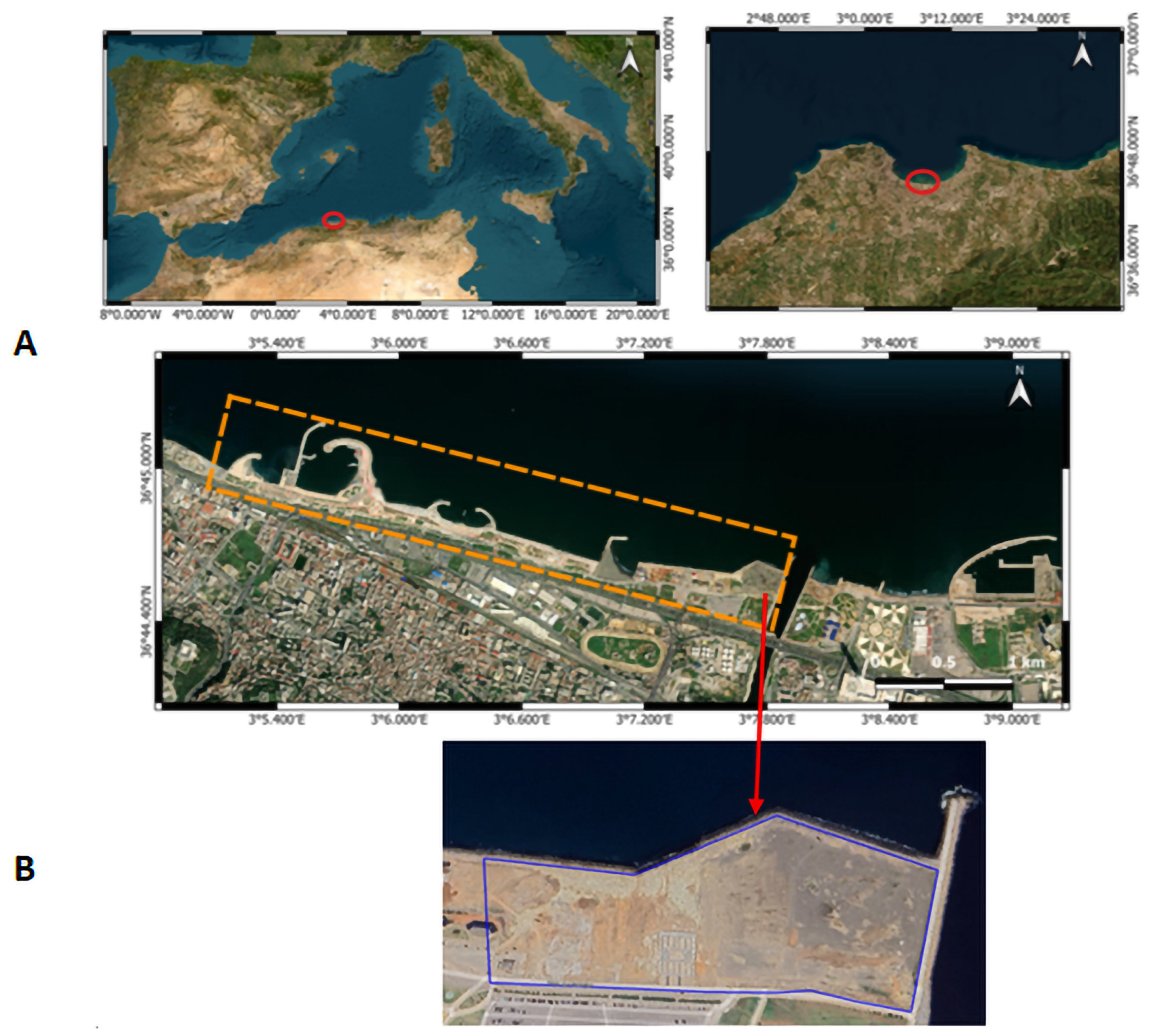
Nestled within the enclosed bay of Algiers, the 4.5 km promenade of Sablettes represents a typical example of a heavily engineered urban coastline. Stretching from Oued El-Harrach in the east to the seawater desalination plant near the port in the west offering panoramic views of this enclosed sea, between coordinates 36.752 N 03.076 E and 36.741 N 03.131 E (Figure 1).
Figure 1.
Location of the study site at the Sablettes Promenade, Algiers, northern Algeria. (A) Regional context showing the position of Algiers Bay along the Mediterranean coast (red circle indicates the study location). (B) Detailed view of the promenade: the orange line indicates the park boundaries; the blue line delineates the area actively monitored for plover nests during 2020–2025.
This landscaped walkway, covering approximately 7.5 hectares, serves as a focal point of intense recreational and social activity. Its very design concentrating human visitation along a narrow coastal strip creates a powerful spatial gradient of anthropogenic pressure (Figure 1).
2.2. Anthropogenic Pressure
The Sablettes promenade is one of the busiest recreational sites in Algiers. During our fieldwork, we observed constant pedestrian traffic and vehicle movement throughout the day. According to unpublished data provided by the Parks, Sports and Leisure Office (OPLA, Wilaya d’Alger), the site receives up to 200,000 visitors on summer weekends. Even in winter, daily attendance exceeds 30,000 during school holidays.
The COVID-19 pandemic temporarily altered this pattern. After several months of closure in spring–summer 2020, the promenade reopened on 16 August 2020 and immediately attracted 40,000 visitors and 2500 vehicles in a single day. The influx of visitors forced the authorities to close the site again in June and July 2021. Once restrictions ended, visitor numbers quickly returned to pre-pandemic levels, reaching 200,000 per weekend by 2023–2024. This sharp contrast between low and high visitation periods allowed us to compare breeding success under different levels of human pressure.
2.3. Data Collection
Fieldwork was conducted from early February to late July during six consecutive breeding seasons (2020–2025). Survey effort consisted of 2–3 visits per week during the pre-breeding period (February–March), increasing to daily visits once the first nest was discovered (typically early April). Nest searches were conducted systematically by walking parallel transects spaced 10–15 m apart across the entire monitored area (Figure 1). Nest searches were conducted rapidly (typically less than 2 h for the entire site). Once a nest was found, it was marked during the first visit using small natural markers (stones or shell fragments). Each nest was assigned a unique identification code, and GPS coordinates were recorded for each nest location. No nest visits were conducted during extreme weather conditions including heavy rain, strong wind, or extreme heat exceeding 35 °C. Approaches were made from different angles to avoid creating visible paths to nests, and observers wore neutral-colored clothing and avoided sudden movements. Pair formation and territorial behavior were monitored using binoculars (Nikon 7 × 40) and a camera (Nikon P1000, Nikon Corporation, Tokyo, Japan) to document breeding activity without approaching birds closely. These precautions were taken to minimize observer-induced disturbance [24].
A nest was considered successful when at least one egg hatched. Hatching was determined by (1) the presence of a hatched chick in the nest or at close proximity, (2) one egg displayed proof of impending hatching (cracked eggshell), or (3) egg disappearance coinciding with the expected hatching date without any indication of predation. A nest was considered failed when (1) egg remnants were found, (2) the nest was abandoned, or (3) eggs disappeared before the expected hatching date [25,26]. However, systematic quantification of failure mechanisms was not conducted, and many failures occurred without clear attribution to a specific cause.
Although formal mark-recapture methods were not employed, we minimized detection bias through systematic coverage of the entire study area during each visit, increased visit frequency once breeding activity was detected, and the use of multiple observers (2–3 people) during peak nesting periods to cross-validate nest locations. However, we acknowledge that some nests may have been missed, particularly those that failed very early in incubation before daily monitoring began. Our detection probability was likely high due to the relatively small size of the monitored area (7.5 ha), the open nature of the habitat with limited vegetation cover, intensive search effort during the peak season, and conspicuous alarm behavior of adult plovers when nests were approached.
2.4. Statistical Analysis
To compare overall breeding success between the COVID-19 and post-COVID periods, we used Fisher’s exact test, pooling data across both species. This non-parametric test is appropriate for contingency table analysis with small sample sizes and provides an exact p-value without relying on asymptotic approximations. We calculated the odds ratio (OR) with 95% confidence intervals to quantify the magnitude of difference between periods.
Breeding success was compared between periods (COVID-19: 2020–2021 vs. post-COVID: 2022–2025) and species (KP vs. LRP) using a Generalized Linear Model (GLM) with binomial error distribution and logit link function.
The model included Period and Species as fixed effects. We tested for Period × Species interaction to assess whether temporal patterns differed between species.
Odds ratios with 95% confidence intervals were calculated by exponentiating model coefficients. All statistical analyses were conducted in Python 3.13 using the statsmodels package (version 0.14.0) and scipy.stats module. Statistical significance was assessed at α = 0.05.
2.5. Remote Sensing
2.5.1. Description Parameters
Analysis was conducted within a user-defined region of interest and focused on two seasonal windows overlapping the shorebird breeding period: Before (1 April 2020 → 1 July 2020) and After (1 April 2025 → 1 July 2025). The April–July windows were chosen to ensure comparable phenology between years and to capture interannual habitat variability.
2.5.2. Remote-Sensing Data
Sentinel-2 surface reflectance (COPERNICUS/S2_SR_HARMONIZED) provided spectral information for vegetation, water and substrate indices; Sentinel-1 GRD (COPERNICUS/S1_GRD) VV and VH polarizations provided structural/backscatter information; and Dynamic World (GOOGLE/DYNAMICWORLD/V1) supplied per-pixel built-up probability. All products were processed at ~10 m resolution.
2.5.3. Preprocessing and Composites
For each window a median composite (Sentinel-2, Dynamic World) or mean composite (Sentinel-1) was generated and clipped to the study area. sentinel-2 scenes were cloud-filtered with CLOUDY_PIXEL_PERCENTAGE < 10%. Sentinel-1 was filtered to IW mode and ascending passes to reduce acquisition heterogeneity.
2.5.4. Indices and Rationale
From Sentinel-2 we computed NDVI, NDWI, MNDWI, NDBI, BSI and AWEI to represent vegetation, wetness, built/imperviousness and bare substrate. Dynamic World’s built probability and Sentinel-1 VV/VH changes were used to detect anthropogenic conversion and structural changes that spectral indices may miss. These complementary signals were selected to capture habitat variability relevant to shorebirds (vegetation encroachment, water dynamics, substrate availability, and urban conversion).
2.5.5. Change Detection and Normalization
Change images were computed as simple deltas (after − before) for each index. To make metrics comparable, each delta was normalized to −1.1 using local percentile bounds (generally 5th–95th percentile; the final index renormalized using 2nd–98th percentiles) computed over the study area at 10 m.
2.5.6. Composite Habitat Change Index
Per index change images (ΔI = Iafter − Ibefore) were computed for each spectral, SAR, and land cover metric (Section 2.5.4), then normalized to [−1, +1] using 2nd–98th percentile clipping (Section 2.5.5) to standardize scales and reduce outlier influence. Normalized layers (ΔI′) were combined as a weighted sum:
where ΔWater′ combines NDWI, MNDWI, and AWEI, and ΔS1′ represents Sentinel-1 VV + VH backscatter change. Weights (wBSI = 0.30, wNDVI = 0.25, wNDBI = 0.20, wBuilt = 0.25, wWater = 0.15, wS1 = 0.10) were selected based on ecological importance for Kentish and Little Ringed Plovers, with positive weights for habitat improving changes (bare substrate, water) and negative weights for degradation (vegetation, built up).
HabitatChange = wBSI·ΔBSI′ − wNDVI·ΔNDVI′ − wNDBI·ΔNDBI′ − wBuilt·ΔBuilt′ + wWater·ΔWater′ + wS1·ΔS1′
The selection of index weights and percentile cut-offs, while ecologically informed, is heuristic; results should be interpreted as indicative of broad habitat change trajectories. The index is interpreted as a qualitative gradient rather than absolute habitat suitability. Complete scripts are in Supplementary Material S1.
2.5.7. Outputs, Reproducibility and Caveats
The normalized Habitat Change map and an absolute change intensity map were produced; area-based summaries (pixel counts at 10 m) quantified proportions of improving versus degrading habitat. All processing was implemented in Google Earth Engine with parameterized date windows, cloud threshold, percentile limits and index weights to allow sensitivity testing. Median compositing and percentile clipping reduce noise but smooth short-term dynamics; Dynamic World is a model product that can misclassify complex coastal landcovers. Index weights are heuristic and should be validated with field data before management use.
2.5.8. Limitations (Overall)
This approach is robust for detecting broad, seasonally consistent changes but has several important limitations. Median/mean compositing smooths noise yet can obscure short-lived or episodic events. Water and exposed-substrate signals are sensitive to tidal stage; without explicit tidal control, some changes may reflect differences in tide timing rather than true habitat change. Dynamic World and spectral indices (NDBI) can misclassify complex coastal substrates (false built-up hits), and Sentinel-1 is subject to speckle and possible orbit-direction bias when restricted to ascending passes. Index weights and percentile cutoffs are heuristic: results depend on these choices and therefore require sensitivity analysis. Finally, remote sensing infers habitat proxies rather than direct measures of bird use; field validation or high-resolution reference data is required to confirm ecological outcomes.
3. Results
3.1. Nest Density and Effort
Between 2020 and 2025, a total of 105 nests were recorded for the two targeted species (Table 1). The inter-annual variation in nesting activity was very marked, both in terms of number of nests and success rate (χ2 = 31.33, df = 5, p < 0.001).
Table 1.
Comparison of the nest numbers and success clutch between 2020 and 2025 for the two species.
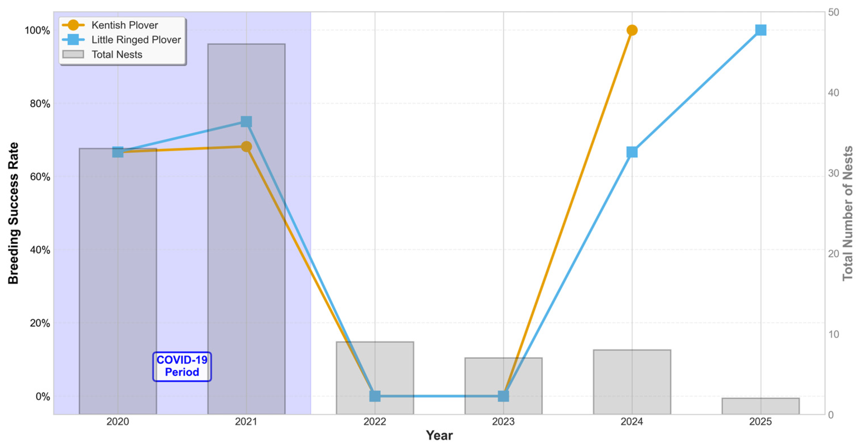
Breeding success was 70% during the COVID-19 period (2020–2021) and 0% during 2022–2023. Breeding success was significantly higher during the COVID-19 restriction period (55/79 nests, 69.6%) (Table 1) compared to the post-COVID period (9/26 nests, 34.6%) (Fisher’s exact test: OR = 4.33, p = 0.002). Nests during the COVID-19 period were 4.3 times more likely to succeed than those in subsequent years.
In 2024 and 2025, the success rate of observed nests was 90%, but total nest numbers were substantially lower (n = 10 over two years) compared to 2020–2021 (n = 79 over two years), representing an 87% decline (Table 1).
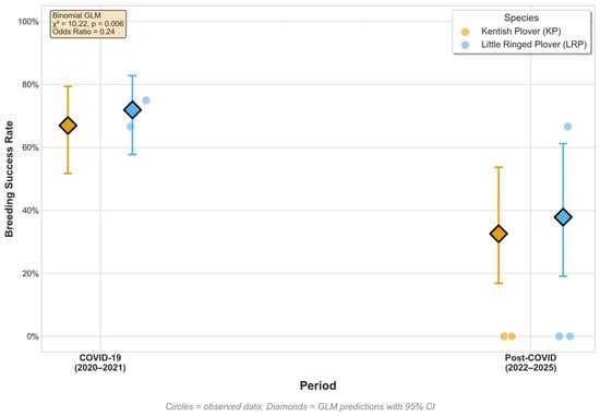
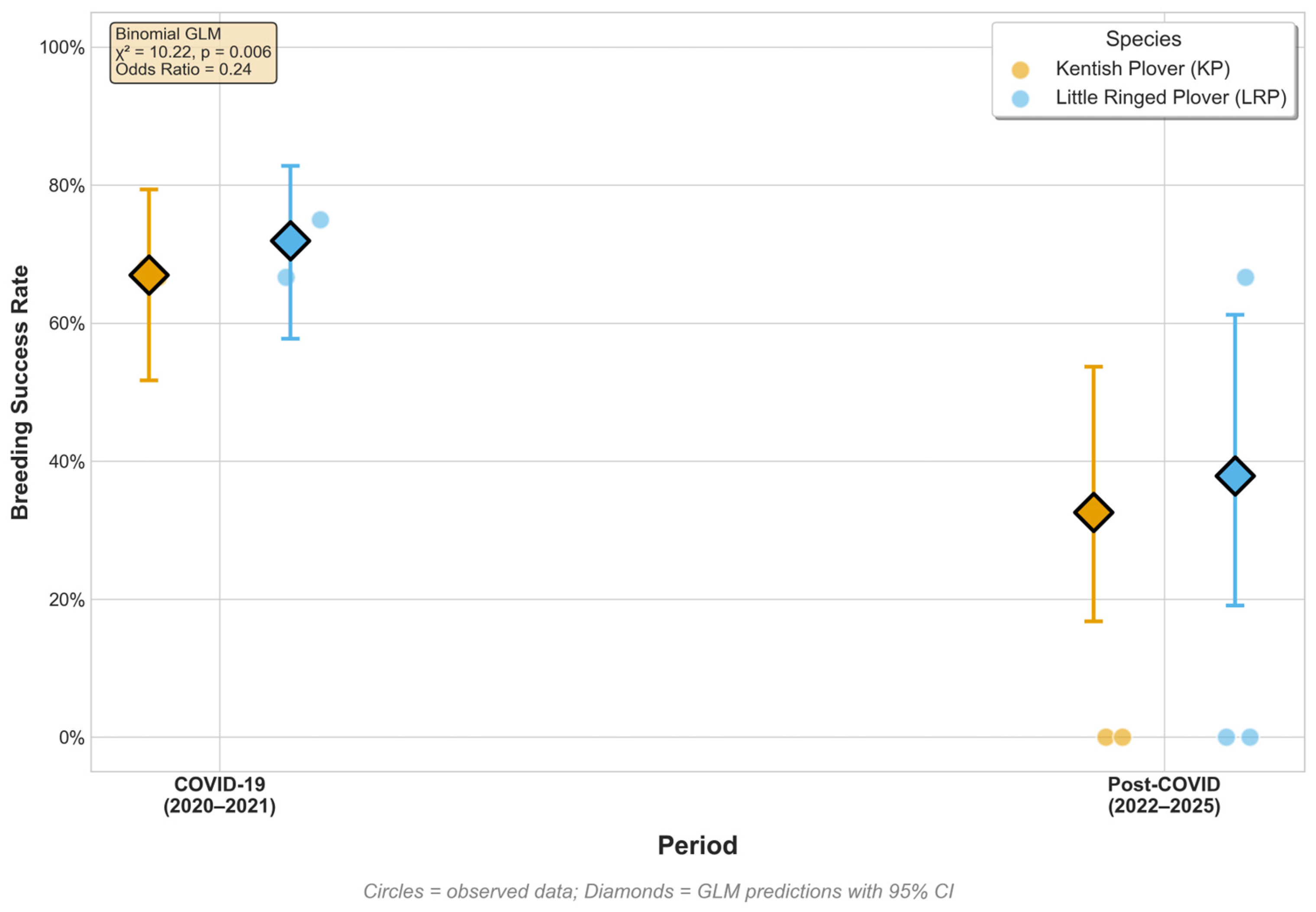
A generalized linear model with a binomial distribution of errors revealed a significant effect of the period on reproductive success (χ2 = 18.37, df = 1, p < 0.001) (Table 2, Figure 2 and Figure 3). Nests built during the COVID-19 period were 4.33 times more likely to succeed (55/79 nests, 69.6%; 95% CI: 57.5–80.1%) than those built after the pandemic (9/26 nests, 34.6%; 95% CI: 20.0–49.9%; OR = 4.33, p < 0.001).
Table 2.
Generalized Linear Model results.
Figure 2.
Observed and predicted breeding success of two plover species based on a Binomial GLM across different anthropogenic activity periods. Small circles = observed data (orange = KP, blue = LRP). Large diamonds = model predictions with 95% CI error bars.
Figure 3.
Annual variation in breeding success rates and nest abundance from 2020 to 2025. Lines with squares = breeding success rate (orange = KP, blue = LRP). Gray bars = total nests. Blue shaded area = COVID-19 period.
Species identity had no significant effect (χ2 = 0.83, p = 0.361), and there was no significant Period × Species interaction (p = 0.837). Model diagnostics indicated good fit (overdispersion ratio = 1.06).
Predicted success rates from the model were as follows: KP 70.0% (95% CI: 57.5–80.1%) during COVID-19 and 33.3% (20.0–49.9%) Post-COVID; LRP 75.9% (64.4–84.7%) during COVID-19 and 43.8% (27.7–61.2%) Post-COVID (Table 2, Figure 2 and Figure 3).
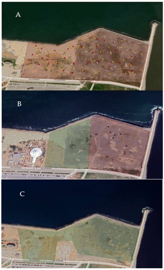
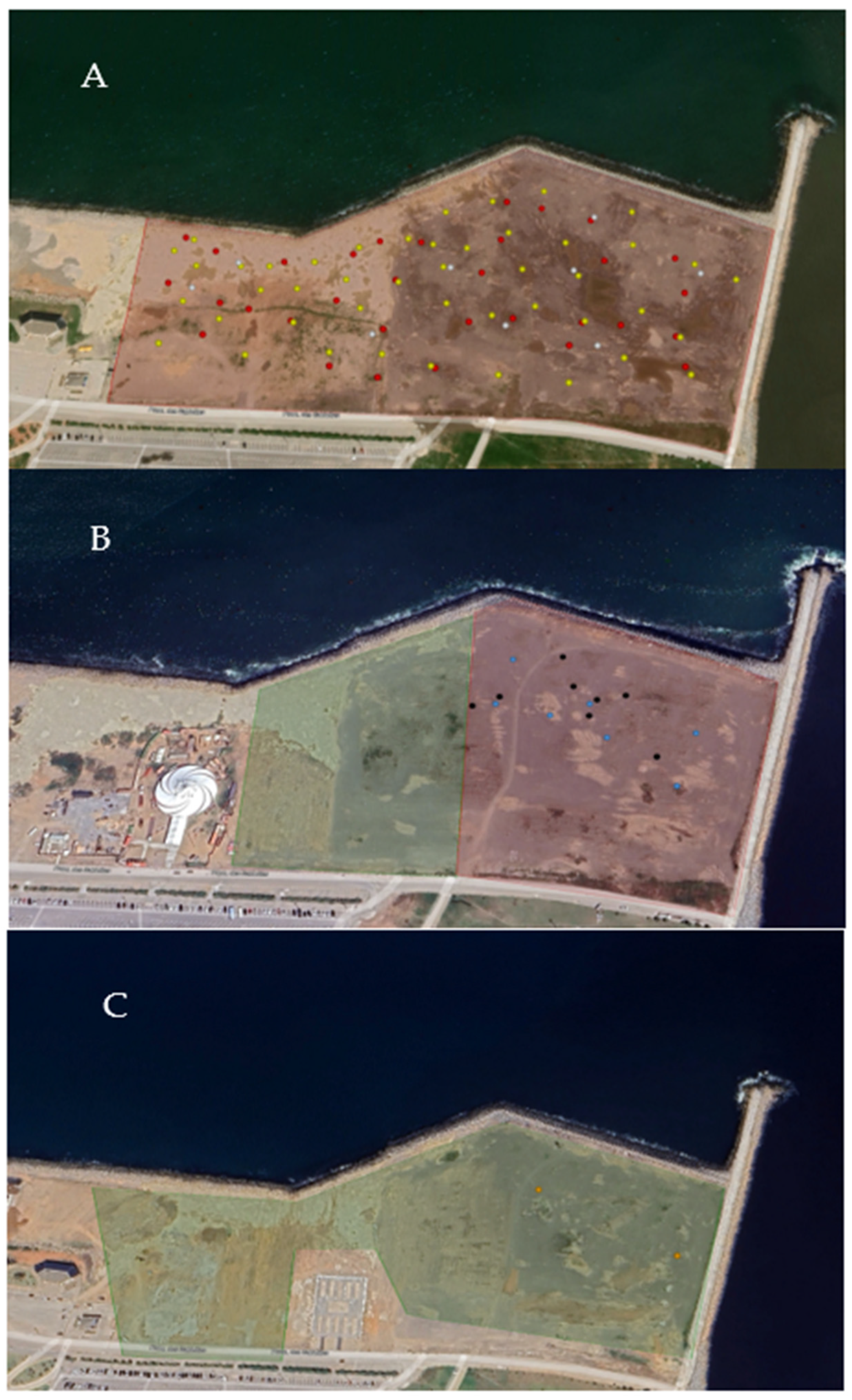
Spatial analysis of nest placement over the six breeding seasons revealed temporal shifts in breeding area usage between years (Figure 4).
Figure 4.
Spatial distribution of plover nests and breeding habitat changes across the study period (2020–2025). (A) Primary nesting area during 2020–2022 (outlined in red); (B) Construction activities in 2022 coinciding with reduced nesting area; (C) 2025 post-hatching zone (green) used by chicks during the fledging period. Nest locations are color-coded by year: red = 2020, yellow = 2021, white = 2022, blue = 2023, black = 2024, orange = 2025.
In 2020, a total of 15 KP nests and 18 LRP nests were recorded. In 2021, nest numbers increased to 22 and 24 nests for KP and LRP, respectively (Table 1).
In 2020 and 2021 breeding success of 70%. The primary nesting area during 2020 to 2022 is outlined in red in (Figure 4A).
In 2022. nine nests, both species, were recorded (Table 1). Construction activities were observed in the nesting area during this breeding season (2022) (Figure 4B). All nests failed (0% hatching success).
In 2023, six KP and one LRP nest were monitored (Table 1), with no successful hatching (0% success). Evidence of predation by gulls and trampling by visitors was observed.
In 2024, five KP and three LRP nests were recorded (Table 1). For the first time since 2021, breeding success was observed. Several adults and chicks were repeatedly seen foraging in the green zone within days post-hatch (Figure 4B). No nests were found in the green zone during the study period. Adults and chicks were repeatedly observed foraging in this area within days post-hatch.
In early 2025, before the breeding season, construction activities were observed within the usual nesting area. A new playground was built nearby, as clearly indicated in Figure 4C.
In 2025, two LRP nests were recorded. These nests are shown in Figure 4C. Both nests were successful, producing at least one hatchling each. Nests were located in the eastern portion of the site. Post-hatching chick movement extended westward into the vegetated area shown in green in Figure 4C. This zone, situated west of the main nesting strip, was consistently used by chicks during the fledging phase.
No nests were detected in this green area during 2025 (Figure 4C), but broods were consistently observed there shortly after hatching.
3.2. Spatial Patterns of Habitat Change (2020–2025)
The baseline composite (April–July 2020) shows habitat conditions during the period when breeding success was 70%.
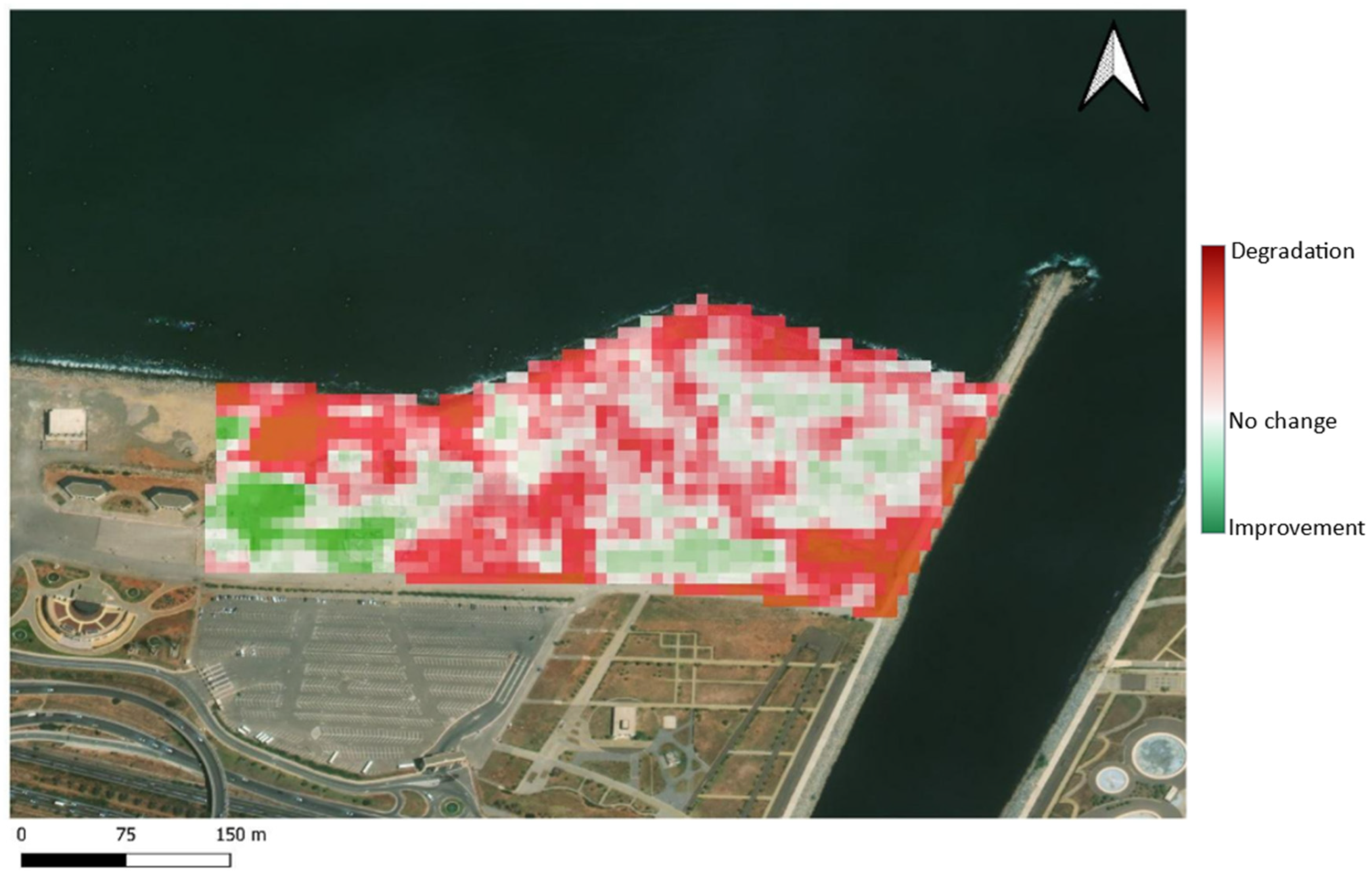
The multi-sensor habitat change analysis reveals spatial heterogeneity across the study area between 2020 and 2025 breeding seasons (Figure 5). The normalized Habitat Change index map displays three distinct zones:
(1) Severe degradation zones (red to dark pink): These areas encompassed approximately 80–85% of the study site, concentrated primarily in central and eastern sectors. Strong negative change values corresponded spatially to areas where nests were recorded during 2020–2021 (Figure 5).
(2) Moderate degradation zones (light pink to white): These areas displayed intermediate negative values and covered 10–15% of the site. The fragmented spatial distribution of these pixels suggests localized, sporadic disturbances rather than systematic habitat alteration, with a fragmented spatial distribution (Figure 5).
(3) Habitat improvement zones (green): Areas showing positive change values, constituted only 5–10% of the total site area; confined primarily to the western periphery. These areas were located where nest and fledglings were repeatedly observed during 2024–2025 (Figure 5).
Figure 5.
Spatiotemporal distribution of habitat changes at the Sablettes Promenade (2020–2025).
4. Discussion
Data collected over a six-year period indicate that plover populations can achieve persistence in heavily urbanized areas, with breeding success showing significant interannual variation associated with anthropogenic pressure. Reproductive success declined sharply from functional breeding in 2020–2021 (during COVID-19 lockdowns with minimal human visitation) to complete failure in 2022–2023. This decline, alongside a persistent drop in nest numbers, was associated with intensified anthropogenic stress on nest site distribution and selection. These patterns align with previous research showing that proximity to human activities consistently decreases nest survival in ground-nesting shorebirds [22]. Studies in Mediterranean coastal sites have documented significant declines in Kentish Plover nesting success near recreational areas [23], with similar negative impacts of pedestrian traffic reported for both plover species [27].
The results of this study contradict the hypothesis that the more flexible LRP would adapt better to the site than the KP. The human pressure at the Promenade of Sablettes is so intense that it exceeds a tolerance threshold for both species. Under such extreme conditions, even species with high tolerance for it will be overwhelmed. Research shows that at this point commonplace activities can trigger complete nest abandonment [28].
Our findings align with recent studies showing that recreational activities negatively affect ground-nesting shorebird reproduction [29,30]. However, our observational approach does not allow clear distinction between direct disturbance effects (human disturbance, nest trampling) and habitat degradation impacts. The degradation detected through remote sensing (80–85% of the study area) suggests these factors are interdependent. Human activities may reduce breeding success both directly through behavioral disruption and indirectly through habitat modification. We acknowledge that certain ecological variables, particularly prey availability, were not quantified in this study.
Predation by predatory mammals, particularly stray dogs, has contributed to nest failure [31,32]. Our field observations have shown that various human activities influence plover behavior during incubation and chick rearing, including organized sporting events attracting large crowds and individual recreational activities (walking, cycling, picnicking) near nesting areas. Temporary structures erected during these events and increased foot traffic have caused repeated disturbances, with walkers and cyclists often unintentionally approaching nests or frightening chicks (Observed by S.C, B.B and I.R).
At this highly disturbed site, both species experienced similar breeding outcomes despite their different ecological strategies, suggesting that extreme disturbance levels may override species-specific adaptations. Our field observations indicated that post-hatch fledgling survival may depend on access to refuge areas with vegetation cover, consistent with recent research highlighting the importance of microhabitat structure for chick survival in disturbed landscapes [33].
The COVID-19 lockdown period (2020–2021) provided a natural experiment for assessing anthropogenic impacts. The sharp decrease in site visits coincided with high reproductive success for both plover species, suggesting that site conditions (substrate, proximity to water) remain favorable for reproduction when disturbance pressure decreases. This temporal pattern suggests that anthropogenic disturbance represents an important constraint on breeding success at this site. However, because habitat degradation (80–85% of the site) occurred concurrently with increased disturbance, and prey availability was not quantified, the relative contributions of direct behavioral disruption versus habitat quality decline remain difficult to separate with our observational data [34,35].
In 2023 and 2024, all nests were discovered in eastern part of the site (red area, Figure 4B). The area is open, with limited vegetative cover, and heavily frequented. The birds nested in this area, but the young of both species were observed flying westward. They were heading toward the green area, adjacent to the red area (Figure 4B). The green area is much more vegetated and less frequented. This suggests that, while initial nesting was limited to the red area, the dispersal of young after hatching likely depends on the availability of nearby vegetated refuge areas. (Observed by S.C, B.B and I.R).
The LPR, despite its documented ability to colonize post disturbance artificial habitats such as quarries [36], remained highly vulnerable to nest destruction during active construction work at our site. This demonstrates that even adaptable species cannot endure intense physical disturbance during breeding, consistent with studies documenting nest abandonment under similar conditions [22,28]. This pattern reinforces that extreme disturbance can override species-specific adaptations.
This study integrates a remote-sensing approach that adds spatial explicitness to behavioral observations by quantifying where and how habitat has degraded. The predominantly negative changes detected across multiple independent sensors (optical, radar, ML land-cover) indicate that degradation is multi-dimensional. This includes not merely increased built-up area, but concurrent loss of bare substrate, vegetation encroachment, altered hydrology, and structural modifications. Such multi-dimensional degradation creates a hostile landscape where species-specific adaptations become less relevant, consistent with recent theoretical work on disturbance thresholds in urban ecosystems [35].
The fragmented spatial pattern of habitat change, characterized by sharp boundaries between degraded and improved zones, underscores the critical importance of habitat heterogeneity for breeding shorebirds in disturbed landscapes [33], studying Piping Plover chick ecology following Hurricane Sandy, demonstrated that vegetation cover and microhabitat structure were the primary drivers of chick survival, with even small patches of appropriate habitat supporting disproportionate breeding success relative to their area.
On the promenade of Sablettes, the limited green zone (<10% of study area) (Figure 5) showing positive habitat change may represent such a micro-refuge. However, its peripheral location and small spatial extent suggest insufficient capacity to support viable populations. Recent studies on shorebird habitat use increasingly emphasize that habitat heterogeneity, with no single patch type being ideal for the entire shorebird community, determines species success [37].
The parallel trajectories observed at geographically distant sites (Mediterranean, East Asia) raise the hypothesis that anthropogenic pressure thresholds for ground-nesting shorebirds may share common features across regions, though comparative studies are needed to test this hypothesis. This pattern underscores the vulnerability of coastal breeding populations to recreational pressure at this and similar urbanized sites.
4.1. Limitations and Future Directions
Our study design, focused on nest outcome rather than daily fate, precluding the use of formal nest survival models. Future research incorporating nest discovery and check dates would allow for more powerful analyses of daily survival rates in relation to fluctuating human activity. Additionally, while temporal and spatial patterns strongly suggest an association between human activity and nest failure, our reliance on coarse administrative visitor estimates rather than fine-scale disturbance measurements limits causal inference.
Future studies would benefit from systematic, high-resolution monitoring of human activity using automated trail counters, camera traps, or direct behavioral observations to quantify disturbance intensity and frequency at nest sites, thereby strengthening conclusions about mechanisms linking anthropogenic pressure to reproductive outcomes.
Furthermore, the opportunistic documentation of nest failure causes precludes quantitative assessment of the relative importance of different mortality drivers (predation, trampling, abandonment, construction impacts) or their potential interactions with human disturbance. Systematic post-failure investigations and video monitoring in future studies could clarify the pathways through which disturbance influences reproductive outcomes.
4.2. Prospects of Conservation
The spatially explicit nature of our habitat change map provides actionable guidance for conservation interventions. Priority should focus on (1) immediate restoration of the extensive degraded zones (>80% of study area), through infrastructure removal, substrate restoration, and seasonal access restrictions during breeding periods (April–July); (2) strict protection of the limited remaining suitable habitat (green zones) (Figure 5) as core breeding areas; and (3) implementation of reproducible monitoring to track restoration effectiveness and detect new threats before they manifest as breeding failures.
The fragmented spatial pattern observed at our site implies that strategic protection of low-use areas combined with restoration of degraded high-use zones could create a complementary network of suitable habitats within a single coastline system. Recent studies on stopover sites have shown that habitat loss at one site is unlikely to be offset by conserving other sites, emphasizing that protecting a significant number of existing key sites is crucial for the conservation of migratory shorebirds [38].
Importantly, the successful breeding documented during 2020–2021 (Table 1) demonstrates that intensive habitat engineering may be unnecessary if disturbance can be controlled. Simple management interventions including symbolic fencing, seasonal closures, signage, and enforcement may rapidly restore functionality given that fundamental habitat qualities remain suitable [30,39].
Predator management represents an additional conservation priority. Symbolic fencing has proven highly effective when combined with predator exclosures and public education. Wire cages that exclude nest predators have been regularly used for management of threatened piping plover populations, with exclosures increasing nest success by 62% over a 34-day period [40]. However, exclosure effectiveness must be carefully evaluated, as exclosed nests show higher abandonment rates, likely indicating adult mortality [40]. A decision support tool (PiperEx) has been developed to help site managers determine whether to use nest exclosures based on site-specific nest-fate data [41]. The Atlantic Coast piping plover population has grown from approximately 957 pairs in 1989 to 2289 pairs in 2021, demonstrating that intensive management combining habitat protection, predator control, and disturbance minimization can achieve recovery goals [42].
Regional coordination is also critical. Both KP and LRP are mobile and may shift breeding locations in response to habitat quality [43]. Conservation strategies should identify and protect alternative breeding sites within dispersal distance, creating a network of complementary habitats rather than relying on single-site protection.
5. Conclusions
This study demonstrates that in heavily urbanized coastal ecosystems, breeding success of ground-nesting shorebirds is strongly influenced by anthropogenic pressure. Our findings suggest that when disturbance levels are extreme, conservation management. may benefit from addressing both anthropogenic disturbance and habitat quality, recognizing these as interdependent factors that jointly influence reproductive outcomes. Recent studies across multiple sites have shown that exceeding certain anthropogenic pressure thresholds may override species-specific adaptations [28], though specific threshold levels likely vary by site and species.
The remote-sensing methodology used in this study could be scaled to regional assessments, identifying priority sites across the Mediterranean coastline for coordinated monitoring and management. Satellite remote sensing is transforming coastal science from a “data-poor” to a “data-rich” field, enabling multiscale monitoring with global coverage and near-daily frequency. The long-standing archive of satellite imagery enables investigation of coastal changes at sites vulnerable to anthropogenic pressures. Advances in machine learning and computer vision are essential for fully leveraging this data repository to provide coastal managers with actionable information for evaluating conservation solutions [44]. The integration of remote sensing data with Geographic Information Systems (GIS) and citizen science activities has proven valuable for enhancing coastal conservation efforts and tracking habitat changes over large spatiotemporal scales [44].
Management recommendations such as seasonal zoning with protective fencing and protection of vegetated refuge habitats would benefit both Kentish and Little Ringed Plovers at this site. By addressing anthropogenic disturbance while maintaining habitat heterogeneity, conditions favorable for the entire community of ground-nesting birds may be created, potentially allowing both specialist and generalist species to successfully reproduce. The challenge at Les Sablettes is therefore to manage both disturbance intensity and habitat quality to create landscape-scale conditions that support coexistence of multiple species with varying ecological requirements.
Supplementary Materials
The following supporting information can be downloaded at https://www.mdpi.com/article/10.3390/birds7010013/s1, Supplementary Material S1: Google Earth Engine (GEE) Script.
Author Contributions
Conceptualization, B.B. and S.C.; methodology, B.B., S.C. and K.E.M.; software, S.C., K.E.M. and G.E.Y.K.; validation, B.B., S.T., A.M. and K.D.; data collection, B.B., I.D., I.E.R., B.M. and S.C.; writing—original draft preparation, B.B., G.E.Y.K. and S.C.; writing—review and editing, S.C., I.D., K.E.M. and G.E.Y.K.; visualization, I.D., K.D., A.M. and B.M.; supervision, B.B. and S.T.; funding acquisition, B.B., I.D., I.E.R. and S.C. All authors have read and agreed to the published version of the manuscript.
Funding
This research received no external funding.
Institutional Review Board Statement
This is an observational study with no physical contact with birds, so ethical approval is not required.
Data Availability Statement
Nesting data are original, details on data availability can be obtained from the corresponding author upon reasonable request. The data used for the Spatial patterns of habitat change study are freely available and were downloaded from Copernicus.
Acknowledgments
We are grateful to all members of the International Wader Study Group (IWSG) who attended the 2024 conference in Montpellier and the 2025 conference in Groningen; their feedback and discussions greatly improved this work. We thank the Parks, Sports and Leisure Office (OPLA), for site access and logistical support throughout the study period.
Conflicts of Interest
The authors declare no conflicts of interest.
Abbreviations
The following abbreviations are used in this manuscript:
| KP | Kentish Plover |
| LPR | Little Ringed Plover |
References
- Schulte, S.A.; Simons, T.R. Factors affecting the reproductive success of American Oystercatchers Haematopus palliatus on the Outer Banks of North Carolina. Mar. Ornithol. 2015, 43, 37–47. [Google Scholar] [CrossRef] [Scilit]
- Aarif, K.M.; Kaiser, S.A.; Nefla, A.; Almaroofi, S. Over-summering abundance, species composition, and habitat use patterns at a globally important site for migratory shorebirds. Wilson J. Ornithol. 2020, 132, 165–172. [Google Scholar] [CrossRef] [Scilit]
- Meager, J.J.; Schlacher, T.A.; Nielsen, T. Humans alter habitat selection of birds on ocean-exposed sandy beaches. Divers. Distrib. 2012, 18, 294–306. [Google Scholar] [CrossRef] [Scilit]
- Schlacher, T.A.; Narayanaswamy, B.E.; Weston, M.A. Spatial Mismatch Between Tourism Hotspots and Anthropogenic Debris on Sandy Beaches in an Iconic Conservation Area. Estuaries Coasts 2025, 48, 21. [Google Scholar] [CrossRef] [Scilit]
- Schlacher, T.A.; Weston, M.A.; Orchard, S.; Kelaher, B.P.; Maslo, B.; Dugan, J.E.; Wiegand, A.N. Adverse impacts of off-road vehicles on coastal dune vegetation are widespread, substantial, and long-lasting: Evidence from a global meta-analysis of sandy beach-dune systems. Estuar. Coast. Shelf Sci. 2025, 312, 109038. [Google Scholar] [CrossRef] [Scilit]
- Chemsedine, N.; Khames, G.E.Y.; Chabani, S.; Mederbal, K.E.; Bakhouche, B.; Saadi, A.; Telailia, S. Seasonal dynamics and habitat use by shorebirds in Mekhada marsh, a mediterranean biodiversity hotspot. Egypt. J. Aquat. Biol. Fish. 2025, 29, 3201–3217. [Google Scholar] [CrossRef] [Scilit]
- Kubelka, V.; Sandercock, B.K.; Székely, T.; Freckleton, R.P. Animal migration to northern latitudes: Environmental changes and increasing threats. Trends Ecol. Evol. 2022, 37, 30–41. [Google Scholar] [CrossRef] [Scilit]
- Stigner, M.G.; Beyer, H.L.; Klein, C.J.; Fuller, R.A. Reconciling recreational use and conservation values in a coastal protected area. J. Appl. Ecol. 2016, 53, 1206–1214. [Google Scholar] [CrossRef] [Scilit]
- Grimm, N.B.; Faeth, S.H.; Golubiewski, N.E.; Redman, C.L.; Wu, J.; Bai, X.; Briggs, J.M. Global change and the ecology of cities. Science 2008, 319, 756–760. [Google Scholar] [CrossRef] [Scilit]
- McKinney, M.L. Urbanization, biodiversity, and conservation: The impacts of urbanization on native species are poorly studied, but educating a highly urbanized human population about these impacts can greatly improve species conservation in all ecosystems. Bioscience 2002, 52, 883–890. [Google Scholar] [CrossRef] [Scilit]
- Maul, G.A.; Duedall, I.W. Demography of coastal populations. In Encyclopedia of Coastal Science; Springer: Cham, Switzerland, 2019; pp. 692–700. [Google Scholar]
- Aarif, K.M.; Nefla, A.; Nasser, M.; Prasadan, P.K.; Athira, T.R.; Muzaffar, S.B. Multiple environmental factors and prey depletion determine declines in abundance and timing of departure in migratory shorebirds in the west coast of India. Glob. Ecol. Conserv. 2021, 26, e01518. [Google Scholar] [CrossRef] [Scilit]
- Morrison, R.G.; Gill, R.E., Jr.; Harrington, B.A.; Skagen, S.K.; Page, G.W.; Gratto-Trevor, C.L.; Haig, S.M. Estimates of Shorebird Populations in North America; Canadian Wildlife Service: Ottawa, ON, Canada, 2001; 64p.
- Morrison, R.I.G.; Ross, R.K.; Niles, L.J.; Gates, H.R.; Peck, M.K.; Gratto-Trevor, C.L.; Koch, S.L.; Pashley, D.N.; Porter, R.R. Dramatic Declines of Semipalmated Sandpipers on Their Major Wintering Areas in the Guianas, Northern South America. Waterbirds 2012, 35, 120–134. Available online: http://www.jstor.org/stable/41432480 (accessed on 20 December 2025). [CrossRef] [Scilit]
- Shamna, H.; Rubeena, K.A.; Naser, H.A.; Athira, T.R.; Singh, A.K.; Almusabeh, A.H.; Zogaris, S.; Al-Sheikhly, O.F.; Xu, Y.; Nefla, A.; et al. Long-Term Population Trends and Diversity Shifts among Shorebirds: A Predictor of Biodiversity Loss along the Arabian Gulf Coasts. Diversity 2023, 15, 468. [Google Scholar] [CrossRef] [Scilit]
- Cooke, S.J.; Piczak, M.L.; Singh, N.J.; Åkesson, S.; Ford, A.T.; Chowdhury, S.; Lennox, R.J. Animal migration in the Anthropocene: Threats and mitigation options. Biol. Rev. 2024, 99, 1242–1260. [Google Scholar] [CrossRef] [Scilit]
- Duan, H.; Yu, X. Spatial and temporal changes in shorebird habitats under different land use scenarios along the Yellow and Bohai Sea coasts in China. Sci. Total Environ. 2024, 929, 172443. [Google Scholar] [CrossRef] [Scilit]
- Yang, C.; Duan, H.; Yu, X. Land use-driven shifts in shorebird habitat connectivity along the Yellow and Bohai Sea coasts: Dynamics and scenario predictions. Biol. Conserv. 2024, 300, 110462. [Google Scholar] [CrossRef] [Scilit]
- Rezouani, I.E.; Boulaouad, B.A.; Chabani, S.; Draidi, K.; Bakhouche, B. Diversity and status of shorebirds in the estuaries of Algiers, northern Algeria. J. Threat. Taxa 2025, 17, 27456–27463. [Google Scholar] [CrossRef] [Scilit]
- Djemadi, I.; Draidi, K.; Bakhouche, B. Recent established population of tree sparrow in Algeria: Palms contributed actively to increasing breeding pairs. Ornithol. Res. 2024, 32, 372–378. [Google Scholar] [CrossRef] [Scilit]
- Draidi, K.; Djemadi, I.; Bakhouche, B. A multi-year survey on aquatic avifauna consolidates the eligibility of a small significant peri-urban wetland in northeast Algeria (Boussedra marsh) to be included on the Important Bird Areas network. Wetl. Ecol. Manag. 2023, 31, 629–648. [Google Scholar] [CrossRef] [Scilit]
- Gómez-Serrano, M.Á. Four-legged foes: Dogs disturb nesting plovers more than people do on tourist beaches. Ibis 2021, 163, 338–352. [Google Scholar] [CrossRef] [Scilit]
- Gómez-Serrano, M.Á.; López-López, P. Deceiving predators: Linking distraction behavior with nest survival in a ground-nesting bird. Behav. Ecol. 2017, 28, 260–269. [Google Scholar] [CrossRef] [Scilit]
- Székely, T.; Kosztolányi, A.; Küpper, C. Practical Guide for Investigating Breeding Ecology of Kentish Plover Charadrius alexandrinus; Version 3; Unpublished Report; University of Bath: Bath, UK, 2008; Available online: https://www.pennuti.net/wp-content/uploads/2010/08/KP_Field_Guide_v3.pdf (accessed on 28 January 2026).
- Bouakkaz, A.; Belhassini, K.; Bensouilah, T.; Bensouilah, M.A.; Houhamdi, M. Breeding behaviour of the Kentish plover (Charadrius alexandrinus) in a salt marsh from the Eastern High Plateaux, northeast Algeria. J. King Saud Univ. Sci. 2017, 29, 291–301. [Google Scholar] [CrossRef] [Scilit]
- Toral, G.M.; Figuerola, J. Nest success of Black-winged Stilt Himantopus himantopus and Kentish plover Charadrius alexandrinus in rice fields, southwest Spain. Ardea 2012, 100, 29–36. [Google Scholar] [CrossRef] [Scilit]
- Weston, M.A.; Ju, Y.K.; Guay, P.J.; Naismith, C. A test of the “Leave Early and Avoid Detection” (LEAD) hypothesis for passive nest defenders. Wilson J. Ornithol. 2018, 130, 1011–1013. [Google Scholar] [CrossRef] [Scilit]
- Lee, D.Y.; Lee, J.H.; Oh, S.J.; Yoon, H.N.; Park, J.Y.; Lee, W.S.; Kim, H.J. Casual birding gone wrong: A case study on the impact of human disturbance on breeding sites of the Kentish plover (Anarhynchus alexandrinus). Wetl. Ecol. Manag. 2025, 33, 68. [Google Scholar] [CrossRef] [Scilit]
- Marasinghe, S.; Simpson, G.D.; Newsome, D.; Perera, P. Scoping recreational disturbance of shorebirds to inform the agenda for research and management in Tropical Asia. Trop. Life Sci. Res. 2020, 31, 51. [Google Scholar] [CrossRef] [Scilit]
- Palacios, E.; Vargas, J.; Fernández, G.; Reiter, M.E. Impact of human disturbance on the abundance of non-breeding shorebirds in a subtropical wetland. Biotropica 2022, 54, 1160–1169. [Google Scholar] [CrossRef] [Scilit]
- Gautschi, D.; Čulina, A.; Heinsohn, R.; Stojanovic, D.; Crates, R. Protecting wild bird nests against predators: A systematic review and meta-analysis of non-lethal methods. J. Appl. Ecol. 2024, 61, 1187–1198. [Google Scholar] [CrossRef] [Scilit]
- Robinson, S.G.; Black, K.M.; Catlin, D.H.; Wails, C.N.; Karpanty, S.M.; Bellman, H.; Fraser, J.D. Red fox trap success is correlated with piping plover chick survival. J. Wildl. Manag. 2024, 88, e22538. [Google Scholar] [CrossRef] [Scilit]
- Robinson, S.G.; Gibson, D.; Alexander, C.R.; Farmer, A.; Jannsen, J.A.M.; Catlin, D.H. Piping plover chick ecology following landscape-level disturbance. J. Wildl. Manag. 2023, 87, e22325. [Google Scholar] [CrossRef] [Scilit]
- Lafferty, K.D. Birds at a Southern California beach: Seasonality, habitat use and disturbance by human activity. Biodivers. Conserv. 2001, 10, 1949–1962. [Google Scholar] [CrossRef] [Scilit]
- McDonald, G.C.; Bede-Fazekas, Á.; Ivanov, A.; Crecco, L.; Székely, T.; Kosztolányi, A. Landscape and climatic predictors of Kentish Plover (Charadrius alexandrinus) distributions throughout Kazakhstan. Ibis 2022, 164, 949–967. [Google Scholar] [CrossRef] [Scilit]
- Cramp, S.; Simmons, K.E.L.; Brooks, D.C.; Collar, N.J.; Dunn, E.; Gillmor, R.; Hollom, P.A.D.; Hudson, R.; Nicholson, E.M.; Ogilvie, M.A.; et al. Handbook of the Birds of Europe, the Middle East and North Africa. The Birds of the Western Palearctic: 3. Waders to Gulls; Oxford University Press: Oxford, UK, 1983; 913p. [Google Scholar]
- VanDusen, B.M.; Fegley, S.R.; Peterson, C.H. Prey Distribution, Physical Habitat Features, and Guild Traits Interact to Produce Contrasting Shorebird Assemblages among Foraging Patches. PLoS ONE 2012, 7, e52694. [Google Scholar] [CrossRef] [Scilit] [PubMed]
- Wang, X.; Chen, Y.; Melville, W.; Lei, F.; Lu, W.; Yin, Y.; Cheng, L. Impacts of habitat loss on migratory shorebird populations and communities at stopover sites in the Yellow Sea. Biol. Conserv. 2022, 269, 109557. [Google Scholar] [CrossRef] [Scilit]
- Jackson, M.V.; Mott, R.; Delean, S.; Hunt, B.J.; Brookes, J.D.; Cassey, P.; Prowse, T.A. Shorebird habitat selection and foraging behaviour have important implications for management at an internationally important non-breeding wetland. Ecol. Solut. Evid. 2024, 5, e12316. [Google Scholar] [CrossRef] [Scilit]
- Stantial, M.L.; Cohen, J.B.; Darrah, A.J.; Maslo, B. Predator exclosures increase nest success but reduce adult survival and increase dispersal distance of Piping Plovers, indicating exclosures should be used with caution. Ornithol. Appl. 2024, 126, duad047. [Google Scholar] [CrossRef] [Scilit]
- Darrah, A.J.; Cohen, J.B.; Castelli, P.M. A decision support tool to guide the use of nest exclosures for Piping Plover conservation. Wildl. Soc. Bull. 2020, 44, 480–492. [Google Scholar] [CrossRef] [Scilit]
- U.S. Fish and Wildlife Service (USFWS). Abundance and Productivity Estimates—2021 Update Atlantic Coast Piping Plover Population. Available online: https://www.fws.gov/media/abundance-and-productivity-estimates-2021-update-atlantic-coast-piping-plover-population (accessed on 23 December 2025).
- Smith, P.A.; Smith, A.C.; Andres, B.; Francis, C.M.; Harrington, B.; Friis, C.; Brown, S. Accelerating declines of North America’s shorebirds signal the need for urgent conservation action. Ornithol. Appl. 2023, 125, duad003. [Google Scholar] [CrossRef] [Scilit]
- Caldareri, F.; Sulli, A.; Parrino, N.; Dardanelli, G.; Todaro, S.; Maltese, A. On the shoreline monitoring via earth observation: An isoradiometric method. Remote Sens. Environ. 2024, 311, 114286. [Google Scholar] [CrossRef] [Scilit]

Disclaimer/Publisher’s Note: The statements, opinions and data contained in all publications are solely those of the individual author(s) and contributor(s) and not of MDPI and/or the editor(s). MDPI and/or the editor(s) disclaim responsibility for any injury to people or property resulting from any ideas, methods, instructions or products referred to in the content. |
© 2026 by the authors. Licensee MDPI, Basel, Switzerland. This article is an open access article distributed under the terms and conditions of the Creative Commons Attribution (CC BY) license.