


Abstract
Solar resource assessment is essential for supporting renewable energy planning in rural and non-interconnected regions where direct irradiance measurements are limited. This study estimated monthly global solar radiation for municipalities in seven departments using five sunshine-based empirical models: Angström–Prescott, Page, Glover–McCulloch, Bahel, and Dogniaux–Lemoine. Estimates were compared with NASA POWER data using correlation, R2, RMSE, and MBE. Annual mean daily estimates ranged from 5.02 to 5.80 kWh m−2 day−1. However, R2 values of 0.21–0.23, moderate correlations, and positive MBEs indicated limited municipality-level predictive performance and systematic overestimation. The Page model produced the lowest overall errors, whereas Glover–McCulloch generated the highest estimates and deviations. These results support regional screening for decentralized renewable energy planning and the development of sustainable communities, but local calibration and ground-based radiometric validation are required before photovoltaic system design.
1. Introduction
Solar radiation influences a wide range of physical, chemical, and biological processes occurring at the Earth’s surface and constitutes a fundamental input for the development of solar-based energy and environmental technologies [1,2]. The most accurate method for quantifying solar radiation at a given site relies on direct measurements using radiometric instruments; however, the installation, operation, and maintenance of such equipment involve high costs and technical requirements [3]. As a result, solar radiation data remain scarce or incomplete in many regions of the world, particularly in rural and non-interconnected areas of developing countries, where insufficient observational coverage restricts the design and evaluation of solar energy [4].
Reliable solar radiation information is required for multiple applications, including thermal load analysis, renewable energy system design, agricultural modeling, hydrological studies, and environmental impact assessments. In this context, empirical and semi-empirical models have been widely employed to estimate global solar radiation using commonly available meteorological and astronomical parameters [5]. Studies of these approaches indicate that models based on sunshine duration, temperature, or cloudiness can provide acceptable accuracy when calibrated for local conditions, particularly in regions lacking long-term radiometric measurements [6,7].
Among empirical approaches, sunshine-based models have been applied due to the relative simplicity and availability of sunshine duration data [8]. The Angstrom–Prescott formulation remains one of the most frequently used correlations for estimating global solar radiation, as it establishes a linear relationship between extraterrestrial radiation and the ratio of actual to maximum possible sunshine duration [9]. Additional formulations, such as those proposed by Page, Bahel, Glover and McCulloch, and Dogniaux and Lemoine, introduce alternative parameterizations that account for geographic and climatic variability, extending their applicability to data-scarce environments [10,11].
In Colombia, the evaluation of solar energy potential has gained relevance within the framework of national energy transition policies that promote the integration of non-conventional renewable energy sources [12]. Rural and non-interconnected zones, which cover a substantial portion of the national territory, face structural limitations in energy access and infrastructure availability [13]. Within this context, the Caribbean region exhibits favorable solar conditions associated with its geographic location and climatic characteristics, although the density of meteorological stations remains limited in several areas [14]. Previous regional studies have demonstrated the feasibility of applying empirical solar radiation models using available government data [15], reporting satisfactory agreement between estimated and measured values in different locations [16,17].
Beyond energy generation, solar resource availability plays a strategic role in supporting sustainable communities in rural and non-interconnected regions [18]. Studies highlight that solar-based systems represent one of the most viable pathways for improving resilience, energy security, and quality of life in remote communities where conventional infrastructure remains limited [19]. Reliable access to solar energy can facilitate the deployment of decentralized solutions for electricity generation, water disinfection, telecommunications, healthcare services, agricultural production, and educational infrastructure, contributing directly to several Sustainable Development Goals (SDGs), particularly SDG 7 (Affordable and Clean Energy), SDG 6 (Clean Water and Sanitation), and SDG 11 (Sustainable Communities) [20,21].
Based on these considerations, this study estimates the solar energy potential in non-interconnected zones of the Colombian Caribbean region using five empirical sunshine-based radiation models. The results are used to characterize the spatial and temporal availability of solar resources and to evaluate their potential contribution to sustainable community applications in data-scarce rural environments. It is hypothesized that sunshine-based empirical models can provide useful estimates of solar energy availability in rural Caribbean regions, supporting preliminary planning and decision-making processes for decentralized renewable energy solutions and sustainable community development.
2. Materials and Methods
2.1. Study Area and Data Sources
The study focuses on rural and non-interconnected zones of the Colombian Caribbean region, where the availability of continuous and reliable solar radiation measurements is limited. These areas are characterized by warm climatic conditions and spatial variability in meteorological parameters such as precipitation and humidity, which influence solar energy availability. Due to the absence of meteorological stations within several of the evaluated locations, monthly average data from the nearest stations operated by the Institute of Hydrology, Meteorology and Environmental Studies of Colombia, IDEAM, were used [15]. Station selection was based on geographic proximity and climatic representativeness. The input data included monthly average sunshine duration, geographic latitude, and the astronomical parameters required for solar radiation estimation. This approach is consistent with previous studies that apply empirical radiation models in regions with scarce direct irradiance measurements [6,17].
2.2. Solar Radiation Estimation Models
Global daily solar radiation on a horizontal surface was estimated using five empirical sunshine-based models commonly reported in the literature due to their applicability and consistent performance under data-scarce conditions. The selected formulations were Angstrom–Prescott, Glover & McCulloch, Dogniaux & Lemoine, Page, and Bahel (Table 1) [8,11]. These models relate global solar radiation to extraterrestrial radiation through the ratio between measured sunshine duration and the maximum possible astronomical sunshine duration.
Table 1.
Selected empirical sunshine-based models used for estimating global solar radiation.
In the selected formulations, H represents the estimated daily global solar radiation on a horizontal surface (Wm−2), while H0 corresponds to the daily extraterrestrial solar radiation received on a horizontal plane at the top of the atmosphere. The variables S and S0 represent the measured sunshine duration and the maximum possible astronomical sunshine duration, respectively. The parameter φ denotes the geographic latitude of the evaluated location, whereas a and b correspond to empirical regression coefficients associated with atmospheric transmissivity and local climatic conditions. The selected empirical models differ primarily in their parameterization structure and incorporation of geographic effects. While the Angstrom–Prescott, Page, and Bahel formulations are based on generalized sunshine-duration relationships, the Glover & McCulloch and Dogniaux & Lemoine models explicitly incorporate latitude-dependent corrections [8], allowing improved representation of solar radiation behavior in low-latitude regions such as the Colombian Caribbean.
The Angstrom–Prescott model was adopted as the reference formulation due to its extensive validation and widespread application in global solar radiation estimation studies across different climatic regions. This model establishes a linear relationship between global solar radiation and sunshine duration ratio, allowing the empirical coefficients to be adjusted according to local atmospheric conditions and geographic characteristics [9]. In the present study, the regression coefficients were selected according to values recommended for tropical and subtropical environments, considering the limited availability of site-specific calibration data.
The empirical coefficients were selected to preserve the published parameterizations of the models and enable their comparison under identical input conditions, rather than to obtain locally optimized formulations. In the Angstrom–Prescott and Glover & McCulloch formulations, the empirical coefficients a and b were determined according to the relationships proposed by Rietveld (1978), which are based on average sunshine duration conditions [22]. For the Glover & McCulloch model, coefficient values of 0.29 and 0.52 were adopted for parameters a and b, respectively, following recommendations reported for low-latitude regions [23]. Re-estimating these coefficients against NASA POWER data was avoided because the same dataset was used as the reference for model evaluation, which could introduce circularity. The Page and Bahel models were additionally included due to their generalized empirical structure and reported applicability across diverse climatic conditions and geographic regions worldwide.
2.3. Astronomical Parameter Calculation
Daily extraterrestrial solar radiation (H0) and maximum possible sunshine duration (S0) were calculated using standard astronomical relationships based on geographic latitude, solar declination, solar constant, eccentricity correction factor, and solar hour angle. These parameters provide the basis for estimating extraterrestrial solar radiation on a horizontal surface and are commonly applied in solar engineering studies [7]. The Earth’s angular position around the Sun (α) was determined as a function of the Julian day (nd) according to Equation (6):
Solar declination (δ) was subsequently calculated using the Fourier series representation proposed by Spencer (1971) [24], as expressed in Equation (7):
δ = 0.006918 − 0.399912 cos α − 0.070257 sin α − 0.006758 cos 2α + 0.0000907 sin 2α − 0.002697 cos 3α + 0.00148 sin 3α
The maximum possible astronomical sunshine duration (S0) was calculated from the solar hour angle (ω) and site latitude (φ) using Equation (8):
The eccentricity correction factor for the Earth–Sun orbit (E0) and the solar hour angle (ω) were determined using Equations (9) and (10), respectively:
E0 = 1.00011 + 0.034221 cos α + 0.00128 sin α + 0.000719 cos 2α + 0.000077 sin 2α
ω = cos−1(−tan φ tan δ)
Finally, extraterrestrial solar radiation on a horizontal surface (H0) was calculated using Equation (11):
where I0 represents the solar constant (1367 Wm−2). The resulting parameters were subsequently used to estimate monthly average global solar radiation through the empirical sunshine-based models presented in Table 1.
2.4. Evaluation of Solar Energy Potential
Estimated global solar radiation values were analyzed on a monthly average basis for each evaluated location in order to characterize the temporal and spatial distribution of solar energy availability across rural and non-interconnected zones of the Colombian Caribbean region. The assessment included 92 municipalities distributed within the departments of Atlántico, Bolívar, Cesar, Magdalena, Córdoba, Sucre, and La Guajira. The estimated irradiance values obtained from the empirical sunshine-based models were compared with satellite-derived solar radiation data obtained from the Prediction Of Worldwide Energy Resources (POWER) platform developed by the National Aeronautics and Space Administration (NASA). This comparison was conducted to evaluate the consistency and predictive performance of the selected formulations under regional climatic conditions.
Prediction errors were defined as ei = Hest,i − Href,i. Model performance was assessed using Mean Bias Error (MBE), Root Mean Square Error (RMSE), Mean Square Error (MSE), coefficient of determination (R2), and Pearson’s correlation coefficient (r). MBE was calculated as the arithmetic mean of the signed residuals; therefore, positive values indicate overestimation and negative values indicate underestimation relative to the reference dataset.
Spatial distribution maps of annual average global solar radiation were subsequently generated for each empirical model to evaluate regional consistency and identify geographic variations in solar energy availability across the study area. The resulting estimations were finally interpreted in terms of their applicability for decentralized solar-based technologies in data-scarce rural environments.
3. Results and Discussion
3.1. Temporal Behavior of Estimated Solar Radiation
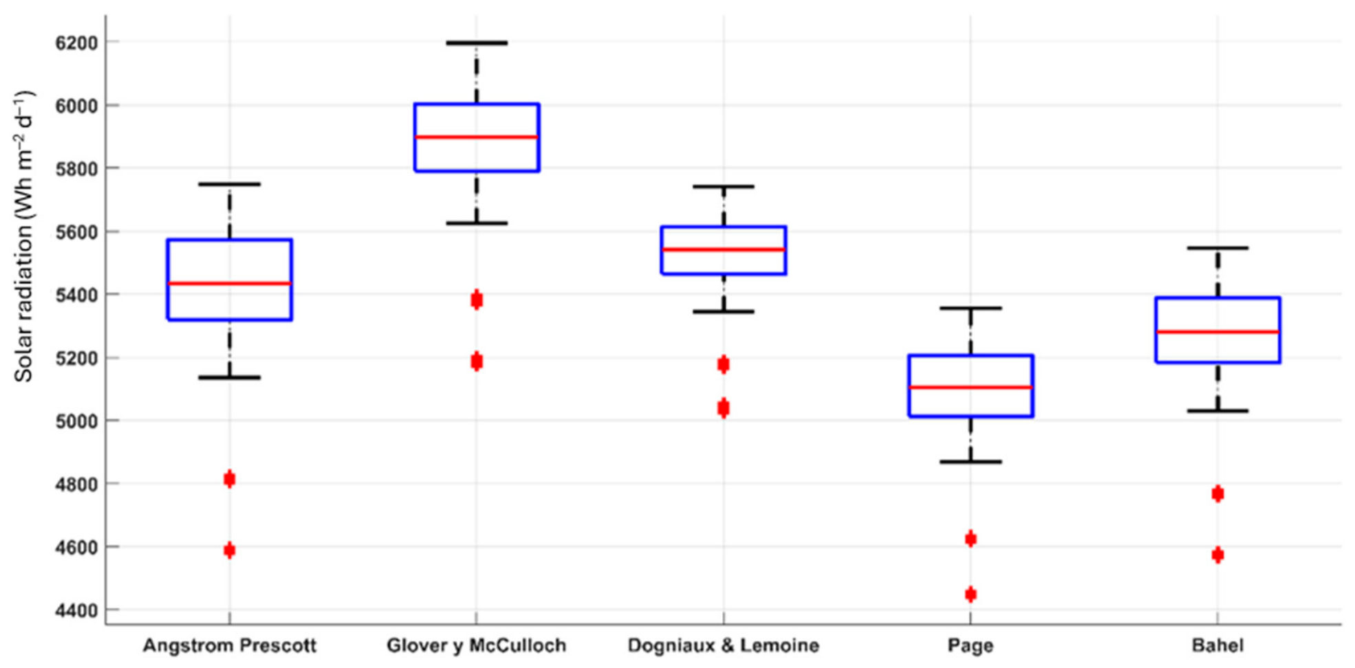
The estimation of global solar radiation using the five empirical sunshine-based models allowed the characterization of solar energy availability across rural and non-interconnected areas of the Colombian Caribbean region. The obtained values reflect the influence of astronomical parameters, particularly solar declination and day length, which govern the seasonal variability of incoming solar radiation and are incorporated into all evaluated formulations. Figure 1 summarizes the annual distribution of estimated global solar radiation for the five empirical models.
Figure 1.
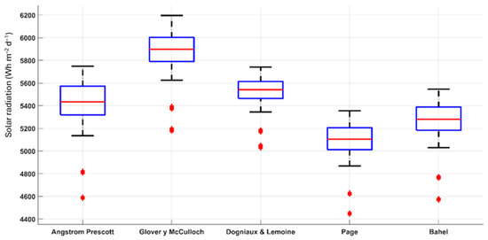
Annual variation in estimated global solar radiation for each evaluated location using the five empirical models (n = 92).
Annual median values ranged from approximately 5.10 kWh m−2 day−1 for the Page model to nearly 5.90 kWh m−2 day−1 for the Glover & McCulloch formulation. The latter consistently produced the highest radiation estimates, whereas the Page model yielded the lowest values. Angstrom–Prescott, Dogniaux & Lemoine, and Bahel presented intermediate results, with median annual estimates between approximately 5.30 and 5.60 kWh m−2 day−1. Despite differences in magnitude, all models exhibited relatively narrow interquartile ranges, indicating limited spatial variability among the evaluated municipalities and suggesting a generally homogeneous solar resource throughout the study area. The boxplots also reveal the presence of a limited number of lower-value outliers, particularly for the Angstrom–Prescott, Page, and Bahel models. These observations are likely associated with municipalities characterized by reduced sunshine duration or local climatic conditions that temporarily decrease solar availability. However, the overall distributions remain relatively compact, reinforcing the stability of the regional solar resource.
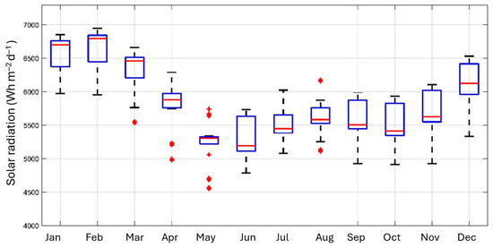
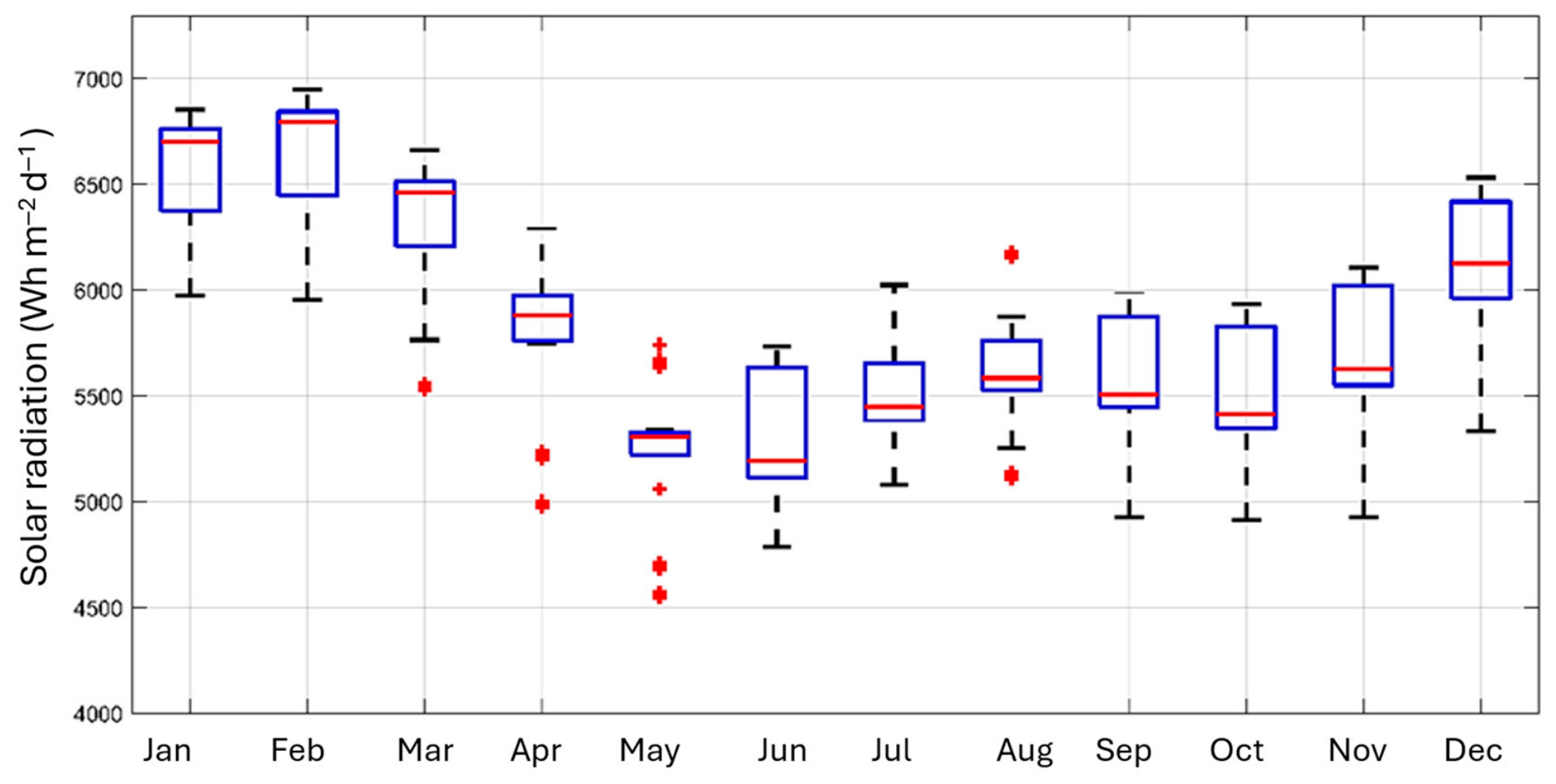
The temporal distribution of estimated solar radiation is presented in Figure 2. Monthly median values remained above approximately 5.00 kWh m−2 day−1 throughout the year, confirming the absence of pronounced seasonal fluctuations. The highest estimated irradiance levels were observed during the first months of the year and towards the end of the annual cycle, where median values frequently exceeded 6.00 kWh m−2 day−1. In contrast, a moderate reduction was observed during the central months, with median values generally ranging between 5.20 and 5.60 kWh m−2 day−1. This pattern is consistent with the seasonal displacement of the Intertropical Convergence Zone and the associated variations in cloud cover and precipitation across the Caribbean region.
Figure 2.
Monthly average estimated global solar radiation values obtained from each empirical model for the evaluated locations (n = 92).
The influence of the ITCZ on the estimated annual radiation cycle occurs mainly through its effects on moisture convergence, convective cloudiness, and sunshine duration, rather than through a direct modification of extraterrestrial radiation; increased cloudiness reduces S/S0 and, consequently, the radiation estimated by sunshine-based models [7,17,25,26]. During boreal winter, particularly from December to February, the ITCZ is displaced southward, northeasterly trade winds intensify, and precipitation decreases over much of the Colombian Caribbean, favoring clearer conditions and higher solar availability [17,27]. As the ITCZ migrates northward during boreal spring, enhanced moisture convergence and convection initiate the regional rainy-season transition, increasing cloud cover and reducing bright-sunshine duration and estimated surface radiation [26]. The principal regional rainy period generally occurs between August and November, when the ITCZ reaches approximately 10–12° N and the trade winds weaken; the resulting increase in precipitation and cloud persistence is therefore expected to attenuate the solar radiation reaching the surface [25,27]. However, the mid-year response is more complex because the Caribbean intermittent dry period and the seasonal strengthening of the Caribbean Low-Level Jet can temporarily reduce convection in some areas, producing spatially variable plateaus or partial recoveries in solar availability rather than a uniform regional decline [25,26]. Accordingly, the temporal patterns obtained in this study are consistent with seasonal ITCZ modulation, but they also reflect interactions with regional circulation, geographic heterogeneity, monthly averaging, and the station-derived sunshine-duration inputs used by the empirical models [15,26,27].
Overall, the five empirical models reproduced similar temporal patterns despite differences in their parameterization structure, indicating that sunshine duration constitutes a robust predictor of global solar radiation under the climatic conditions of the Colombian Caribbean region. Annual median estimates ranged from approximately 5.10 kWh m−2 day−1 for the Page model to nearly 5.00 kWh m−2 day−1 for the Glover & McCulloch formulation, while the Angstrom–Prescott, Dogniaux & Lemoine, and Bahel models produced intermediate values. The systematically higher estimates generated by the Glover & McCulloch model can be attributed to its explicit incorporation of latitude-dependent terms, which tend to increase predicted irradiance under low-latitude conditions. In contrast, the Page model provided more conservative estimates while maintaining similar temporal behavior. Comparable inter-model differences have been reported in comparative assessments of sunshine-based radiation models, where latitude-corrected formulations often produce higher irradiance estimates than generalized empirical approaches [6,23].
The relatively narrow interquartile ranges and the common seasonal trends observed across all formulations suggest that model selection has a limited influence on the overall characterization of solar resource availability at monthly time scales. Nevertheless, the interquartile ranges observed in the boxplots in Figure 1 and Figure 2 should not be interpreted exclusively as evidence of an inherently homogeneous solar resource. They partly reflect the spatial and temporal aggregation of the input data: the models were applied using monthly climatological averages, and multiple municipalities within the same department were assigned the same station-derived sunshine-duration series. Consequently, differences among these locations were generated mainly by latitude-dependent astronomical parameters, while subregional variations in cloud cover, precipitation, relative humidity, aerosols, and local topography were not explicitly represented [10].
The broadly similar temporal patterns produced by the five formulations reflect their common dependence on relative sunshine duration S/S0, a well-established proxy for monthly solar availability; however, their differences in magnitude arise from the use of distinct functional forms and empirical coefficients originally derived under different geographical and atmospheric conditions [8,28]. This is particularly evident for the Glover–McCulloch model. At the low latitudes of the Colombian Caribbean, the term cos φ is approximately 0.283–0.288, representing an effective intercept higher than that of the Page model (0.23), while its slope is also greater (0.52 versus 0.48). Therefore, the higher Glover–McCulloch estimates are structurally embedded in its parameterization rather than being caused by greater sunshine duration at the evaluated locations. Over the range of S/S0 observed in this study, this comparatively high baseline transmissivity also maintained the Glover–McCulloch estimates above those obtained with the alternative linear, latitude-adjusted, and cubic formulations. Nevertheless, this ordering should not be interpreted as an inherent superiority of any functional form because empirical coefficients represent site-dependent atmospheric transmissivity and may vary with latitude, altitude, solar elevation, water vapor, and atmospheric pollution [23]. Previous assessments have shown that model performance can change among months and that equations transferred between regions may systematically overestimate or underestimate radiation under different atmospheric conditions [8]. Moreover, geographically adjusted coefficients improved the Angström–Prescott and Bahel models, while incorporating relative humidity increased estimation accuracy in humid regions [10]. Similarly, although the cubic model provided a slightly better regression fit in Tunisia, its advantage over the linear formulation was not statistically significant [28]. Thus, the systematic positive bias of Glover–McCulloch in the present study suggests that its generic coefficients impose a higher effective atmospheric transmissivity than that supported by the regional reference data, underscoring the importance of local calibration in specific field applications.
3.2. Statistical Performance of Empirical Models
The statistical performance indicators obtained for the five empirical sunshine-based models are presented in Table 2. Overall, the models exhibited comparable performance when evaluated against satellite-derived solar radiation data from the NASA POWER database. The Page model yielded the lowest error values, with RMSE and MSE values of 1.075 and 1.155, respectively, indicating the closest agreement with the reference dataset. In contrast, the Glover & McCulloch model produced the highest error values, with RMSE and MSE values of 1.822 and 3.319, respectively, suggesting a tendency to overestimate solar radiation under the evaluated conditions.
Table 2.
Statistical performance indicators of the empirical sunshine-based models used to estimate global solar radiation in the Colombian Caribbean region.
The Angstrom–Prescott, Dogniaux–Lemoine, and Bahel models exhibited intermediate performance, with RMSE values ranging from 1.232 to 1.502 kWh m−2 day−1. All formulations yielded positive MBE values, ranging from 0.982 to 1.767 kWh m−2 day−1, indicating systematic overestimation relative to the reference dataset. The lowest bias was obtained with the Page model, whereas the Glover–McCulloch formulation exhibited the largest deviation. Similarly, Pearson correlation coefficients ranged from 0.458 to 0.481, reflecting moderate positive associations between estimated and reference radiation values across all evaluated models.
Although the R2 values were relatively low (0.21–0.23), they should be interpreted as evidence that the models reproduced only a limited proportion of the linear variability in the NASA POWER reference data, rather than as confirmation of high predictive accuracy. Because R2 was derived from the Pearson correlation, its magnitude is sensitive to the range of the paired observations; restriction of range generally attenuates correlation coefficients and their corresponding R2 values [29]. In this study, monthly climatological averaging may have contributed to this effect by smoothing short-term extremes and reducing temporal dispersion. However, this statistical effect does not fully explain the observed performance. Additional discrepancies may arise from the spatial mismatch between station-derived sunshine-duration data and the gridded NASA POWER product, the use of generic coefficients, and the omission of cloud optical properties, aerosols, and relative humidity. Previous reviews show that the performance of sunshine-based models varies across climatic zones and can improve through local calibration and the incorporation of additional meteorological predictors [6,10]. Similar observations have been reported in studies evaluating empirical radiation models in tropical and subtropical environments, where low seasonal variability limits the magnitude of R2 despite acceptable predictive accuracy [6,16,17].
Although the Page model yielded the lowest observed error metrics, the differences among models were evaluated descriptively. No inferential test of the paired prediction errors was conducted; therefore, these results do not demonstrate that the Page model is statistically superior to the other formulations. Furthermore, the relatively similar (R2) and Pearson correlation coefficients across models indicate broadly comparable associations with the NASA POWER reference data. Accordingly, Page is identified as the model with the lowest observed errors under the evaluated conditions, rather than as the statistically best-performing model. Conversely, the slightly higher errors observed for the Glover & McCulloch model may be associated with its latitude-dependent parameterization, which can amplify estimated irradiance under low-latitude conditions and lead to moderate overestimations. Similar tendencies have been documented in comparative analyses of empirical radiation models applied in tropical regions, where latitude-corrected formulations often generate higher irradiance estimates than simpler empirical approaches [23,30]. Local calibration would be expected to improve the absolute accuracy of the empirical models by replacing the generic coefficients with parameters that better represent the atmospheric transmissivity, cloud regime, and sunshine–radiation relationship of the Colombian Caribbean [8,10]. Given the systematic positive bias observed for all five formulations, calibration would probably reduce the intercept or slope of their H/H0 relationships, particularly for the Glover–McCulloch model, whose generic parameterization imposes comparatively high baseline transmissivity. This adjustment would likely decrease MBE and RMSE, and improve absolute agreement indicators such as Lin’s concordance coefficient. However, correlation and (R2) may change only marginally because, especially for linear models, modifying the intercept and slope primarily corrects systematic bias and scale rather than the spatial ordering of the estimates.
3.3. Spatial Distribution of Estimated Solar Radiation Across Empirical Models
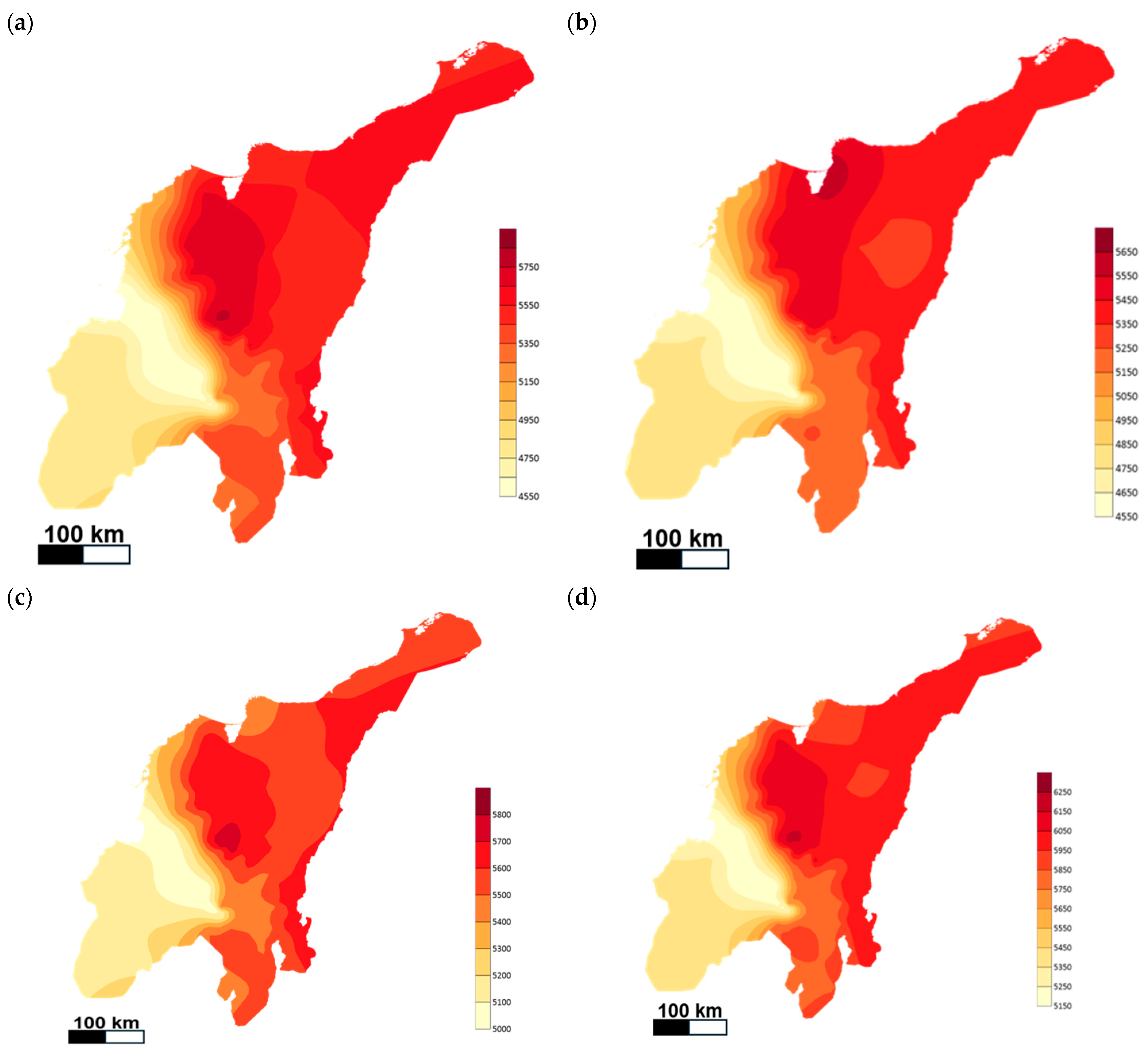
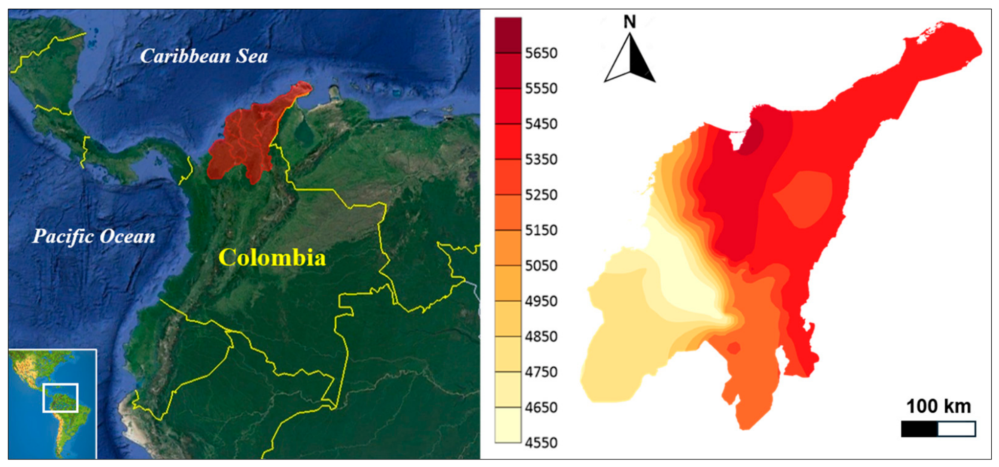
The spatial distribution of annual average global solar radiation estimated using the five empirical sunshine-based models across rural and non-interconnected areas of the Colombian Caribbean region are presented in Figure 3 and Appendix A. Although differences in absolute magnitude were observed among models, all formulations revealed a consistent spatial pattern characterized by higher solar radiation levels in the central and northern sectors of the study area and comparatively lower values toward the southwestern region. Estimated annual average radiation generally ranged between approximately 4.6 and 6.2 kWh m−2 day−1, depending on the model and location considered, confirming the high solar resource availability of the region.
Figure 3.
Estimated spatial distribution of annual average global solar radiation (Wh m−2 day−1).
The highest radiation levels were consistently identified in areas associated with the departments of La Guajira, northern Cesar, and portions of Magdalena, where values frequently exceeded 5.8–6.0 kWh m−2 day−1. In contrast, lower estimates were concentrated toward southern Bolívar and Córdoba, where increased cloud cover, higher precipitation regimes, and local atmospheric conditions may reduce the amount of incident solar radiation. These spatial gradients are consistent with the climatological characteristics of the Colombian Caribbean, where the combined influence of trade winds, seasonal precipitation patterns, and the Intertropical Convergence Zone (ITCZ) generates regional differences in sunshine duration and cloudiness [15].
Despite the differences in parameterization among the evaluated formulations, the spatial configuration of high- and low-radiation zones remained remarkably similar. The Glover & McCulloch model generally produced the highest radiation estimates throughout the region, whereas the Page model generated the most conservative values. However, the relative distribution of solar potential remained unchanged, indicating that model selection influences the magnitude of the estimates more strongly than the identification of priority areas for solar energy development. This behavior suggests that the observed spatial patterns are predominantly driven by regional climatic and geographic factors rather than by the mathematical structure of the empirical models. The estimated radiation levels are consistent with previous assessments of solar resources in northern Colombia and other tropical regions, where annual average global solar radiation commonly exceeds 5.0 kWh m−2 day−1 and exhibits relatively low spatial variability compared with mid- and high-latitude environments [15,17,31].
Because all five formulations depend primarily on S/S0 and H0, the use of shared sunshine-duration inputs inevitably produces compact distributions and smooths local contrasts [8,10]. Nevertheless, a genuine geographical component also contributes to the limited dispersion: the Colombian Caribbean occupies a relatively narrow low-latitude range, where differences in day length and solar elevation are comparatively small, resulting in broadly similar extraterrestrial radiation levels [7]. This astronomical consistency should not, however, be equated with climatic uniformity. The region presents a marked northeast–southwest climatic gradient, from the drier and less cloudy conditions of La Guajira to the more humid and precipitation-influenced environments of southern Bolívar, Córdoba, and Sucre [15]. More specifically, lower precipitation, less persistent cloud cover, and longer sunshine duration favor higher S/S0 ratios in La Guajira, whereas greater precipitation and cloud persistence reduce sunshine duration and the resulting radiation estimates toward the southern Caribbean. These relationships are interpretative because precipitation, relative humidity, and cloud cover were not incorporated as independent predictors in the evaluated models. Therefore, the boxplots indicate limited variability at the spatial and temporal resolution adopted in this study, rather than complete homogeneity of the regional solar resource. A denser station network, shorter temporal resolution, and the inclusion of atmospheric variables would likely reveal greater municipality-level heterogeneity.
At the regional scale, the annual mean daily estimates obtained in this study were 5.02, 5.19, 5.33, 5.47, and 5.80 kWh m−2 day−1 for the Page, Bahel, Angström–Prescott, Dogniaux–Lemoine, and Glover–McCulloch models, respectively, with municipality-level values ranging from 4.44 to 6.20 kWh m−2 day−1. This range is generally consistent with the high solar-resource classes mapped for the Colombian Caribbean by the national solar atlas, although the level of agreement differs among models [15,32]. Updated climatological records from 24 IDEAM automatic and conventional stations in the seven evaluated departments show an overall mean of 5.11 kWh m2 day−1 and a range of 3.95–5.66 kWh m−2 day−1 with departmental means of 5.30 in La Guajira, 5.16 in Bolívar, and 4.57 in Córdoba [32]. Thus, the Page and Bahel estimates are closest to the regional observational level in aggregate, whereas Angström–Prescott and Dogniaux–Lemoine occupy its upper portion and Glover–McCulloch produces comparatively high values. Values above 6.0 kWh m−2 day−1 have been reported for selected areas of La Guajira; 32.88% of its territory is classified within 6.01–6.50 kWh m−2 day−1 [33], but updated IDEAM mapping places most of the department between 5.0 and 5.4 kWh m−2 day−1, with values above 5.4 concentrated in specific sectors. The comparatively lower averages of 4.6–5.0 kWh m−2 day−1 reported for Antioquia further support the national north–south resource gradient [16]. Nevertheless, differences among reference products remain relevant as an 8.29% positive bias has been identified in CMIP6 surface solar radiation for the Caribbean relative to ERA5 [34].
3.4. Applications for Sustainable Communities
The relevance of this assessment extends beyond solar-resource characterization because differences in the magnitude estimated by the models translate into different assumptions for photovoltaic system design, cost, and reliability. Although the five models produce broadly similar spatial patterns and therefore lead to relatively consistent regional prioritization, their differences affect the expected energy yield used to determine array capacity and system configuration. The comparatively high estimates from Glover–McCulloch could overstate photovoltaic production, potentially resulting in undersized arrays, insufficient battery-recharging margins, and reduced service reliability, whereas the more conservative Page estimates could lead to larger systems and higher initial investment but provide a greater operational safety margin. Based on the validation statistics reported in Table 2, community-scale planning should consider resource-estimation errors on the order of 1.1–1.8 kWh m−2 day−1 (RMSE). These values characterize uncertainty in the solar-resource input rather than a confidence interval for the required photovoltaic or storage capacity. Therefore, the model results should be incorporated into low-, central-, and high-resource scenarios during preliminary sizing rather than relying on a single estimate without local verification. This consideration is especially important in the Colombian Caribbean, where rural and Non-Interconnected Zones continue to face disparities in access to energy, water, healthcare, education, and digital connectivity [35,36,37]. At this scale, the results support the prioritization of decentralized systems for electrification, water pumping, irrigation, refrigeration, telecommunications, and other essential services. However, final implementation should combine locally calibrated or measured radiation data with hourly demand profiles, technical sizing, storage and autonomy requirements, lifecycle costs, maintenance capacity, local governance, and participatory planning [18,38].
From an application perspective, the estimated radiation levels support the potential deployment of solar technologies oriented toward sustainable community development rather than a single end-use application. In rural contexts, solar energy can contribute to household and community electrification, water pumping, agricultural irrigation, crop drying, refrigeration, telecommunications, education services, and healthcare infrastructure. These uses are consistent with the role of decentralized renewable energy systems as enablers of broader development outcomes, including poverty reduction, improved access to basic services, increased resilience, and progress toward the Sustainable Development Goals [18,19,21]. In this sense, the solar resource maps generated in this study provide a technical basis for prioritizing municipalities where solar-based interventions could support community-scale infrastructure and productive activities. The spatial patterns identified in this work are also relevant for the planning of hybrid and stand-alone renewable energy systems in isolated communities. Previous reviews of hybrid renewable energy systems in micro-communities show that project performance depends not only on resource availability, but also on demand profiles, storage requirements, system configuration, financing, governance, maintenance capacity, and community participation [19,20,38].
3.5. Study Limitations
The results of this study should be interpreted as a regional-scale solar resource assessment rather than as a site-specific design study. Although the astronomical variables were calculated using the coordinates of each municipality, sunshine-duration data were obtained from the nearest available meteorological stations rather than from co-located observations. Differences in cloud cover, precipitation, humidity, elevation, coastal influence, and topography between the stations and the target municipalities therefore introduce spatial representativeness uncertainty. The empirical coefficients were adopted from the literature without local calibration; consequently, they may not fully represent the regional relationship between atmospheric transmissivity and relative sunshine duration, contributing to the systematic biases observed among the models. This uncertainty propagates through the S/S0 ratio and may produce either local overestimation or underestimation; however, its magnitude could not be quantified directly because co-located sunshine-duration and radiometric measurements were unavailable. Although cloudiness is partly represented indirectly through the relative sunshine-duration ratio S/S0, the evaluated empirical models do not explicitly account for cloud optical properties, aerosol loading, or relative humidity. These factors modify atmospheric transmissivity and the partitioning of direct and diffuse radiation and may therefore contribute to the residual discrepancies between the model estimates and the NASA POWER reference product; however, their individual contributions cannot be isolated using the available monthly climatological data [10,34]. Furthermore, the use of monthly climatological averages and, in some cases, the same station series for several municipalities may smooth local spatial contrasts and does not capture hourly variability, extreme cloudiness events, or short-term operational constraints. Spatial interpolation may introduce additional uncertainty in areas with limited station coverage. Consequently, the estimates provide an initial screening of regional solar potential but should not be used directly for infrastructure sizing or investment decisions. Before implementation, they should be complemented with site-specific radiometric monitoring, local demand assessment, socioeconomic characterization, technical sizing, cost and uncertainty analyses, and participatory planning.
4. Conclusions
The findings demonstrate the value of sunshine-based models for characterizing broad solar-resource patterns in data-scarce areas of the Colombian Caribbean. The estimates provide useful preliminary information for identifying and prioritizing areas where decentralized solar solutions could be explored. During subsequent detailed engineering and implementation phases, municipality-level applications should be supported by local model calibration and participatory planning. The proposed approach can also inform future research agendas and public policy initiatives aimed at strengthening technology management and supporting the planning and implementation of community-scale renewable energy projects in rural and Non-Interconnected Zones.
Author Contributions
Conceptualization, F.A. and J.P.; methodology, F.A., J.L.G. and J.P.; software, F.A.; validation, A.S.-C., C.D.-M. and J.P.; formal analysis, F.A., A.S.-C., J.L.G. and J.P.; writing—original draft preparation, F.A. and A.S.-C.; writing—review and editing, J.L.G., C.D.-M. and J.P.; funding acquisition, F.A., C.D.-M. and J.P. All authors have read and agreed to the published version of the manuscript.
Funding
This research was funded by Science and Technology Ministry of Colombia, Grant No. 812 (2018).
Institutional Review Board Statement
Not applicable.
Informed Consent Statement
Not applicable.
Data Availability Statement
Dataset available on reasonable request.
Acknowledgments
The authors acknowledge the support provided by the Universidad Tecnológica de Bolívar for the Master’s in Engineering Scholarship Program (Agreement Number 23—University Academic Council, 2018). The authors also thank the Fundación Universitaria Tecnológico Comfenalco—Cartagena (Colombia), the members of the GISAH Research Group (Universidad Tecnológica de Bolívar), and the GIA Research Group for their support during the development of this work.
Conflicts of Interest
The authors declare no conflicts of interest.
Abbreviations
The following abbreviations are used in this manuscript:
| IDEAM | Institute of Hydrology, Meteorology and Environmental Studies of Colombia |
| NASA | National Aeronautics and Space Administration |
| POWER | Prediction Of Worldwide Energy Resources |
| ITCZ | Intertropical Convergence Zone |
| MBE | Mean Bias Error |
| RMSE | Root Mean Square Error |
| MSE | Mean Square Error |
| SDGs | Sustainable Development Goals |
Appendix A
Figure A1.
Spatial distribution of annual average global solar radiation estimated using the (a) Angstrom–Prescott, (b) Bahel, (c) Dogniaux & Lemoine, and (d) Glover & McCulloch models.
References
- Kishore, T.S.; Kumar, P.U.; Ippili, V. Review of Global Sustainable Solar Energy Policies: Significance and Impact. Innov. Green Dev. 2025, 4, 100224. [Google Scholar] [CrossRef] [Scilit]
- Abed, N.; Afgan, I. An Extensive Review of Various Technologies for Enhancing the Thermal and Optical Performances of Parabolic Trough Collectors. Int. J. Energy Res. 2020, 44, 5117–5164. [Google Scholar] [CrossRef] [Scilit]
- Chisale, S.W.; Lee, H.S.; Soto Calvo, M.A.; Jeong, J.S.; Aljber, M.; Williams, Z.; Cabrera, J.S. Advanced Solar Energy Potential Assessment in Malawi: Utilizing High-Resolution WRF Model and GIS to Identify Optimal Sites for Solar PV Generation. Renew. Energy 2025, 239, 122084. [Google Scholar] [CrossRef] [Scilit]
- Rumbayan, M.; Kindangen, J.; Sambul, A.; Sompie, S.; Cross, J. Solar Energy Implementation in Rural Communities and Its Contributions to SDGs: A Systematic Literature Review. Unconv. Resour. 2025, 6, 100180. [Google Scholar] [CrossRef] [Scilit]
- Paulescu, M.; Badescu, V.; Budea, S.; Dumitrescu, A. Empirical Sunshine-Based Models vs Online Estimators for Solar Resources. Renew. Sustain. Energy Rev. 2022, 168, 112868. [Google Scholar] [CrossRef] [Scilit]
- Besharat, F.; Dehghan, A.A.; Faghih, A.R. Empirical Models for Estimating Global Solar Radiation: A Review and Case Study. Renew. Sustain. Energy Rev. 2013, 21, 798–821. [Google Scholar] [CrossRef] [Scilit]
- Duffie, J.A.; Beckman, W.A.; Blair, N. Solar Engineering of Thermal Processes, Photovoltaics and Wind. Am. J. Phys. 2020, 53, 931. [Google Scholar]
- Al-Mostafa, Z.A.; Maghrabi, A.H.; Al-Shehri, S.M. Sunshine-Based Global Radiation Models: A Review and Case Study. Energy Convers. Manag. 2014, 84, 209–216. [Google Scholar] [CrossRef] [Scilit]
- Almorox, J.; Benito, M.; Hontoria, C. Estimation of Monthly Angström–Prescott Equation Coefficients from Measured Daily Data in Toledo, Spain. Renew. Energy 2005, 30, 931–936. [Google Scholar] [CrossRef] [Scilit]
- Gouda, S.G.; Hussein, Z.; Luo, S.; Yuan, Q. Review of Empirical Solar Radiation Models for Estimating Global Solar Radiation of Various Climate Zones of China. Prog. Phys. Geogr. Earth Environ. 2020, 44, 168–188. [Google Scholar] [CrossRef] [Scilit]
- Zhang, Q.; Cui, N.; Feng, Y.; Jia, Y.; Li, Z.; Gong, D. Comparative Analysis of Global Solar Radiation Models in Different Regions of China. Adv. Meteorol. 2018, 2018, 3894831. [Google Scholar] [CrossRef] [Scilit]
- González-Dumar, A.; Arango-Aramburo, S.; Correa-Posada, C.M. Quantifying Power System Flexibility for the Energy Transition in Colombia. Int. J. Electr. Power Energy Syst. 2024, 155, 109614. [Google Scholar] [CrossRef] [Scilit]
- Cerón, J.A.; Gómez-Luna, E.; Vasquez, J.C. Driving the Energy Transition in Colombia for Off-Grid Regions: Microgrids and Non-Conventional Renewable Energy Sources. Energies 2025, 18, 1010. [Google Scholar] [CrossRef] [Scilit]
- Becerra-Fernandez, M.; Sarmiento, A.T.; Cardenas, L.M. Sustainability Assessment of the Solar Energy Supply Chain in Colombia. Energy 2023, 282, 128735. [Google Scholar] [CrossRef] [Scilit]
- Hurtado Moreno, G.; González, O.C.; Cadena, M.; Benavides, H.; Rúiz, F.; Montealegre, E.; Ortiz Royero, J.C.; Montoya Ramírez, R.D. Atlas Climatológico de Colombia, 2nd ed.; Instituto de Hidrología Meteorología y Estudios Ambientales IDEAM: Bogotá, Colombia, 2017; ISBN 978-958-8067-95-7. [Google Scholar]
- Restrepo Román, A.; Villegas, D.J.; Rodriguez, C.; Cogollo, A.; Bedoya, I.D.; Amell Arrieta, A.A. Implementation of a Hierarchical Cluster Model to Analyze Wind and Solar Availability in the Department of Antioquia, Colombia. Case Stud. Chem. Environ. Eng. 2024, 10, 101006. [Google Scholar] [CrossRef] [Scilit]
- Contreras-Sepúlveda, W.; Galban-Pineda, M.G.; Bustos-Márquez, L.F.; Sepúlveda-Mora, S.B.; Ramírez-Mateus, J.J. Angström-Prescott Empirical Model to Estimate Solar Radiation in Norte de Santander, Colombia. Rev. Investig. Desarro. e Innovación 2021, 11, 413–427. [Google Scholar] [CrossRef] [Scilit]
- Ley, D. Sustainable Development, Climate Change, and Renewable Energy in Rural Central America. In Evaluating Climate Change Action for Sustainable Development; Springer: Berlin/Heidelberg, Germany, 2017; pp. 187–212. [Google Scholar] [CrossRef] [Scilit]
- Neves, D.; Silva, C.A.; Connors, S. Design and Implementation of Hybrid Renewable Energy Systems on Micro-Communities: A Review on Case Studies. Renew. Sustain. Energy Rev. 2014, 31, 935–946. [Google Scholar] [CrossRef] [Scilit]
- Aricapa, F.; Gallego, J.L.; Silva-Cortés, A.; Díaz-Mendoza, C.; Pasqualino, J. Modeling the Performance of Glass-Cover-Free Parabolic Trough Collector Prototypes for Solar Water Disinfection in Rural Off-Grid Communities. Physchem 2026, 6, 9. [Google Scholar] [CrossRef] [Scilit]
- Obaideen, K.; Olabi, A.G.; Al Swailmeen, Y.; Shehata, N.; Abdelkareem, M.A.; Alami, A.H.; Rodriguez, C.; Sayed, E.T. Solar Energy: Applications, Trends Analysis, Bibliometric Analysis and Research Contribution to Sustainable Development Goals (SDGs). Sustainability 2023, 15, 1418. [Google Scholar] [CrossRef] [Scilit]
- Rietveld, M.R. A New Method for Estimating the Regression Coefficients in the Formula Relating Solar Radiation to Sunshine. Agric. Meteorol. 1978, 19, 243–252. [Google Scholar] [CrossRef] [Scilit]
- Aka Djoman, M.; Wanignon Fassinou, F.; Memelèdje, A. General Formulation of Ångström-Prescott Coefficients: A New Approach for Côte d’Ivoire. Int. J. Phys. 2021, 9, 245–250. [Google Scholar] [CrossRef] [Scilit]
- Spencer, J.W. Fourier Series Representation of the Position of the Sun. Search 1971, 2, 172. [Google Scholar]
- Bastidas-Salamanca, M.; Rueda-Bayona, J.G. Effect of Climate Variability Events over the Colombian Caribbean Offshore Wind Resource. Water 2021, 13, 3150. [Google Scholar] [CrossRef] [Scilit]
- Martinez, C.; Muñoz, Á.G.; Goddard, L.; Kushnir, Y.; Ting, M. An Adaptive Approach to Quantify Weather-within-Climate Rainfall Characteristics. Clim. Dyn. 2022, 59, 1997–2024. [Google Scholar] [CrossRef] [Scilit]
- Arregocés, H.A.; Gómez, D.; Castellanos, M.L. Annual and Monthly Precipitation Trends: An Indicator of Climate Change in the Caribbean Region of Colombia. Case Stud. Chem. Environ. Eng. 2024, 10, 100834. [Google Scholar] [CrossRef] [Scilit]
- Chelbi, M.; Gagnon, Y.; Waewsak, J. Solar Radiation Mapping Using Sunshine Duration-Based Models and Interpolation Techniques: Application to Tunisia. Energy Convers. Manag. 2015, 101, 203–215. [Google Scholar] [CrossRef] [Scilit]
- Bland, J.M.; Altman, D.G. Correlation in Restricted Ranges of Data. BMJ 2011, 342, d556. [Google Scholar] [CrossRef] [Scilit]
- Zhang, Y.; Sivakumar, M.; Yang, S.; Enever, K.; Ramezanianpour, M. Application of Solar Energy in Water Treatment Processes: A Review. Desalination 2018, 428, 116–145. [Google Scholar] [CrossRef] [Scilit]
- UPME Plan Energético Nacional 2020–2050: Transformación Energética Para El Desarrollo Sostenible. Available online: https://www.upme.gov.co/simec/planeacion-energetica/plan-energetico-nacional-1/ (accessed on 22 February 2024).
- IDEAM Promedios Climatológicos de Radiación Global Actualizado a 2025. Available online: https://www.ideam.gov.co/sala-de-prensa/informes/publicacion-dom-04052025-1200 (accessed on 16 August 2026).
- Carvajal-Romo, G.; Valderrama-Mendoza, M.; Rodríguez-Urrego, D.; Rodríguez-Urrego, L. Assessment of Solar and Wind Energy Potential in La Guajira, Colombia: Current Status, and Future Prospects. Sustain. Energy Technol. Assess. 2019, 36, 100531. [Google Scholar] [CrossRef] [Scilit]
- Arregocés, H.A.; Rojano, R.; Pimienta, D.P. A Comprehensive Analysis of Future Solar Energy Potential Variations Using a CMIP6 Multi-Model Ensemble Approach in Colombia. Clean Energy 2024, 8, 79–89. [Google Scholar] [CrossRef] [Scilit]
- Tirado-Ballestas, I.P.; Gallego, J.L.; Zuluaga-Ortiz, R.; Roa-Pérez, V.; Silva-Cortés, A.; Sarmiento, M.C.; De la Hoz-Domínguez, E.J. Integrating Socio-Demographic and Local Sustainability Indicators: Implications for Urban Health and Children’s Vulnerability in Henequén Neighborhood in Cartagena, Colombia. Urban Sci. 2025, 9, 220. [Google Scholar] [CrossRef] [Scilit]
- Romero-Murillo, P.; Gallego, J.L.; Leignel, V. Marine Pollution and Advances in Biomonitoring in Cartagena Bay in the Colombian Caribbean. Toxics 2023, 11, 631. [Google Scholar] [CrossRef] [Scilit]
- Roncancio, D.J.; Cutter, S.L.; Nardocci, A.C. Social Vulnerability in Colombia. Int. J. Disaster Risk Reduct. 2020, 50, 101872. [Google Scholar] [CrossRef] [Scilit]
- Montalvo-Navarrete, J.M.; Lasso-Palacios, A.P. Energy Access Sustainability Criteria Definition for Colombian Rural Areas. Renew. Sustain. Energy Rev. 2024, 189, 113922. [Google Scholar] [CrossRef] [Scilit]

Disclaimer/Publisher’s Note: The statements, opinions and data contained in all publications are solely those of the individual author(s) and contributor(s) and not of MDPI and/or the editor(s). MDPI and/or the editor(s) disclaim responsibility for any injury to people or property resulting from any ideas, methods, instructions or products referred to in the content. |
© 2026 by the authors. Licensee MDPI, Basel, Switzerland. This article is an open access article distributed under the terms and conditions of the Creative Commons Attribution (CC BY) license.