


Abstract
For intelligent transportation systems, monitoring road surface integrity is critical for enhancing vehicle safety and infrastructure longevity. Traditional detection relies on high-cost Light Detection and Ranging (LiDAR) and vehicle-mounted sensors that are often computationally expensive and difficult to deploy at scale. This study aims to address the challenge of deploying a high-accuracy CNN on a resource-constrained edge device (Raspberry Pi 4B) by optimizing the balance between inference latency and detection sensitivity. By utilizing a depthwise separable convolution architecture, the system shows a 10% increase in vehicle window area identification accuracy while operating within a low-power envelope of less than 15 W. Experimental results demonstrate that the integrated curvature-based mathematical model improves anomaly detection sensitivity by 15% compared to traditional threshold-based triggers. The developed system reduces hardware expenses to 30% of conventional LiDAR-centric systems, maintaining a real-time inference latency of 120 ms and a packet loss rate below 2% at speeds of 60 km/h. These results establish a cost-effective, edge-intelligent solution for vehicle-road collaborative monitoring, increasing overall driver comfort and safety by 15%.
1. Introduction
Road surface damage has a direct impact on both driving comfort and safety. Conventional driving practices and existing intelligent driver-assistance systems lack effective early-warning mechanisms that account for road conditions, limiting their ability to detect hazards or adjust speed and route proactively. This deficiency not only reduces passenger comfort but also increases the risk of tire blowouts, chassis damage, and unexpected accidents. At present, road damage or abnormalities are primarily detected through manual inspection, which makes timely identification and intervention difficult.
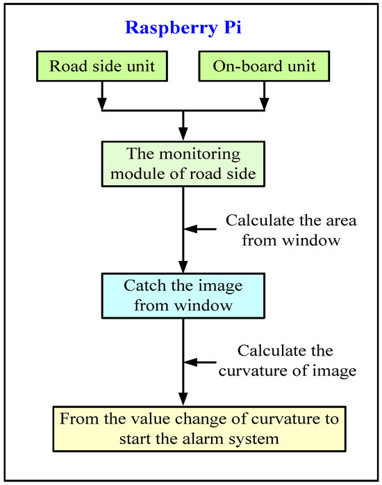
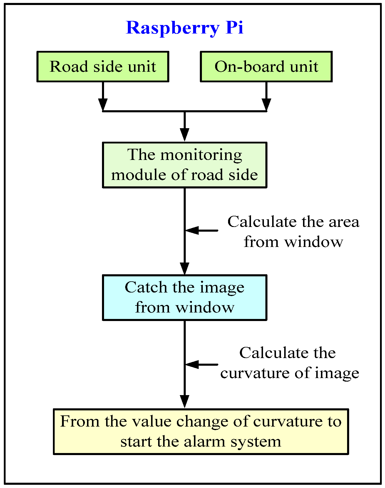
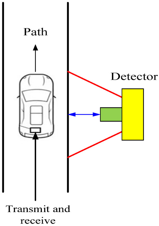
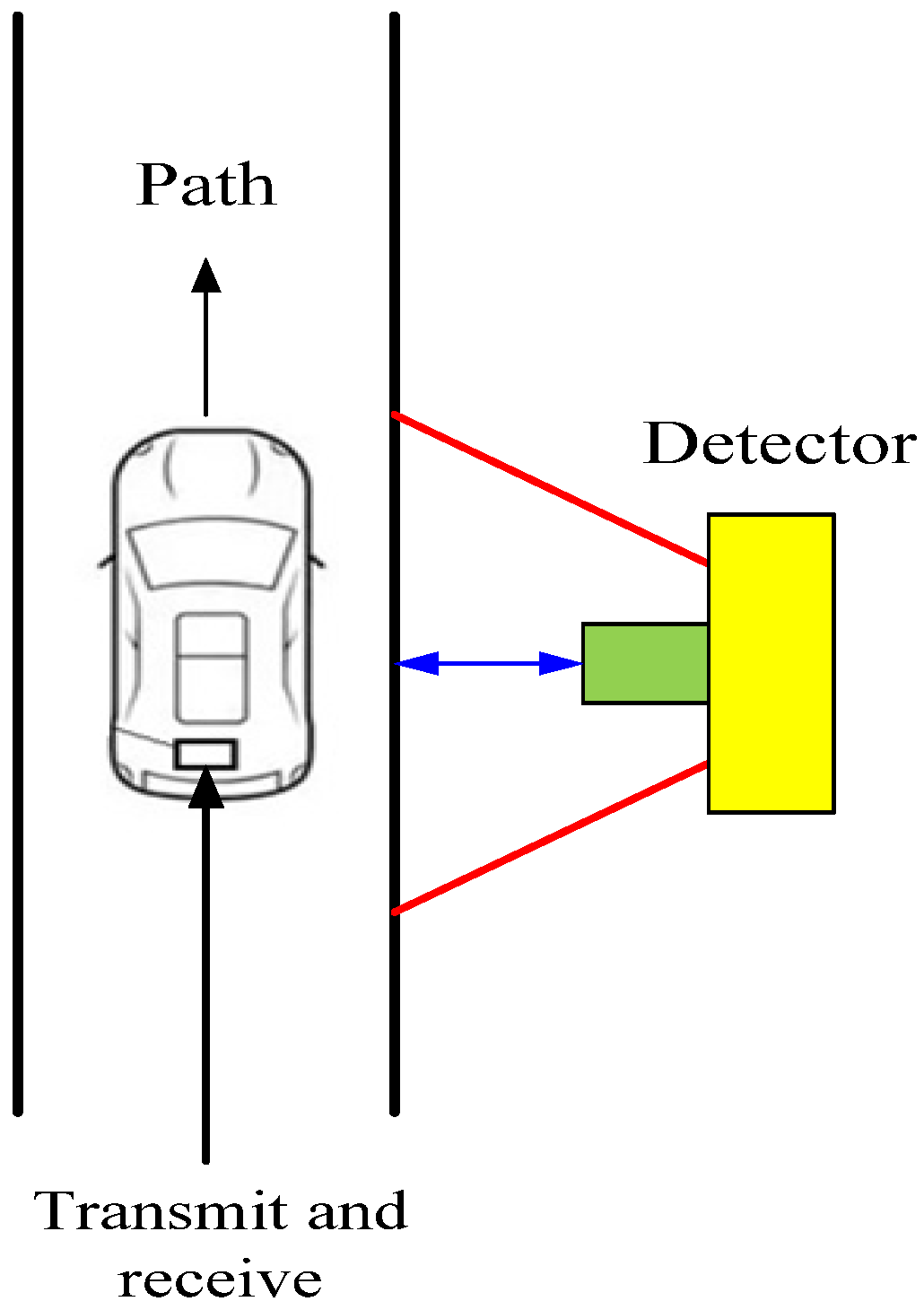
To address these limitations, we propose a novel method for automated road damage detection that integrates vehicle-road collaborative monitoring. The system employs a Raspberry Pi as the central control unit [1], connected with roadside units (RSUs) and on-board units (OBUs). A roadside video monitoring module captures images of vehicle side windows, from which window-area curves are generated in chronological order. Curvature changes are then computed, and when the variation exceeds a predefined threshold, the system issues a warning to the driver. Simultaneously, road damage information is displayed on roadside terminals, prompting drivers to reduce speed or adjust their route. Warning messages are transmitted through RSUs and OBUs, enabling vehicles to adapt driving strategies in advance. In parallel, road damage data are transmitted to relevant authorities to support immediate maintenance, thereby improving both driving safety and repair timeliness. The overall system architecture is illustrated in Figure 1.
Figure 1.
The structure of a vehicle monitoring system.
Other than system integration, this study aims to deploy high-accuracy Convolutional Neural Networks (CNNs) on resource-constrained edge devices. By utilizing a Raspberry Pi as a control unit, the developed system balances computational constraints with real-time performance, requiring optimization between inference latency and detection sensitivity. While traditional high-cost monitoring architectures rely on bulky hardware, the developed system presents algorithmic efficiency to achieve real-time detection while reducing system cost to approximately 30% of conventional solutions. Such an improvement, owing to edge intelligence, enhances the timeliness of road abnormality warnings and provides a scalable framework for intelligent vehicle-road collaboration in future transportation systems.
2. Literature Review
Previous studies have addressed road damage detection, yet the direct detection of road surface damage has not been extensively researched. Mertz et al. developed a smartphone-based system that assesses road damage by detecting cracks. The smartphone, placed on the vehicle’s center console, captures images, integrates global positioning system data, and automatically analyzes and displays a road risk assessment value. This method offers advantages such as low cost and continuous monitoring across an entire urban street network [2]. Similarly, Casas-Avellaneda et al. proposed a pothole detection and positioning system using smartphone sensors, which collects surface data and displays pothole locations on an electronic map. Its expandable mobile architecture allows deployment across multiple devices over large areas [3]. Maeda et al. designed a system in which a mobile phone mounted in a vehicle captures road damage images. CNN is then trained and evaluated on a computer, with results transmitted back to the phone [4]. Zhang employed Mask R-CNN deep learning to establish a road damage recognition model capable of detecting cracks, patches, deformations, and potholes, while continuously retraining based on new data [5]. Chen applied a wide-channel fully convolutional network for road surface detection [6]. Yousaf et al. utilized the Bag-of-Words algorithm to classify pothole and non-pothole images, trained a support vector machine for classification, and applied image segmentation to locate potholes with high accuracy [7].
Hui et al. used three-dimensional laser scanning and Matlab (R2024b, MathWorks, Natick, MA, USA) reconstruction to generate multi-dimensional indicators of potholes [8], and Alvarez and López employed vehicle-mounted cameras to detect free road surfaces [9]. Huo designed a Raspberry Pi-based system that uses accelerometer and gyroscope sensors to collect road condition data, uploads it to a cloud server, and applies the Martin-Franklin method to classify conditions. Uneven road locations are marked on a map, and an application provides driver warnings [10]. Asmiatun et al. developed a system using accelerometer sensors and Z-Diff algorithms to detect potholes with 74% accuracy [11]. Anaissi et al. proposed a Virtual Road Network Inspector based on accelerometers and machine learning, though it exhibited a high false alarm rate [12]. Huang applied mobile cameras and grating projection for nighttime road detection [13].
Pena-Caballero et al. designed an embedded detection and positioning system using the Google Coral Dev Board, capable of identifying, classifying, and recording road hazards at specific locations, while automatically alerting servers and providing information to public and traffic authorities [14]. Zhang and colleagues integrated a laser scanner into a dedicated inspection vehicle to obtain high-frequency cross-sectional elevation data, enabling dense three-dimensional point cloud reconstruction of road surfaces. Yang developed a roadside terminal using Raspberry Pi and a vehicle-mounted terminal with an STM32F407 chip to build an electronic platform for vehicle information extraction, roadside monitoring, vehicle-road interaction warnings, and parking management [15]. Dong leveraged the YOLOv5 network to design an improved vehicle-mounted anomaly detection and positioning system [16]. Peng combined image processing techniques to quantify crack length, width, mesh cracking, and pothole area. Yuan proposed a deep learning–based method for defect detection and driving risk assessment [17], while Pan introduced an improved YOLOv8-based approach for defect detection and autonomous driving risk evaluation.
The previous study results showed that traditional monitoring of abnormal road damage relies on cameras and Light Detection and Ranging sensors installed on vehicles, combined with visual algorithms to detect defects. However, this requires vehicles to be equipped with a complete set of hardware, and conventional manual driving systems cannot fully provide timely warnings. In contrast, we integrate vehicle-road collaboration with the simultaneous development of deployable products.
3. Results
To quantify road abnormalities, the system computes the curvature K of the car window contour from data extracted in preprocessed image frames. For any point (x,y) on the detected contour, the curvature is defined as follows.
Here, x′, y′ and x″, y″ denote the first and second derivatives of the contour coordinates with respect to the curve parameter. By monitoring the variance of K across a chronological sequence, the system identifies sudden deviations in contour geometry. When the change in curvature ΔK exceeds a predefined sensitivity threshold, the event is classified as a road defect.
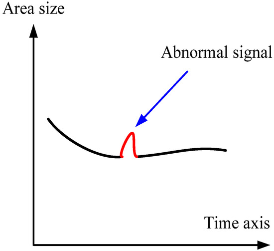
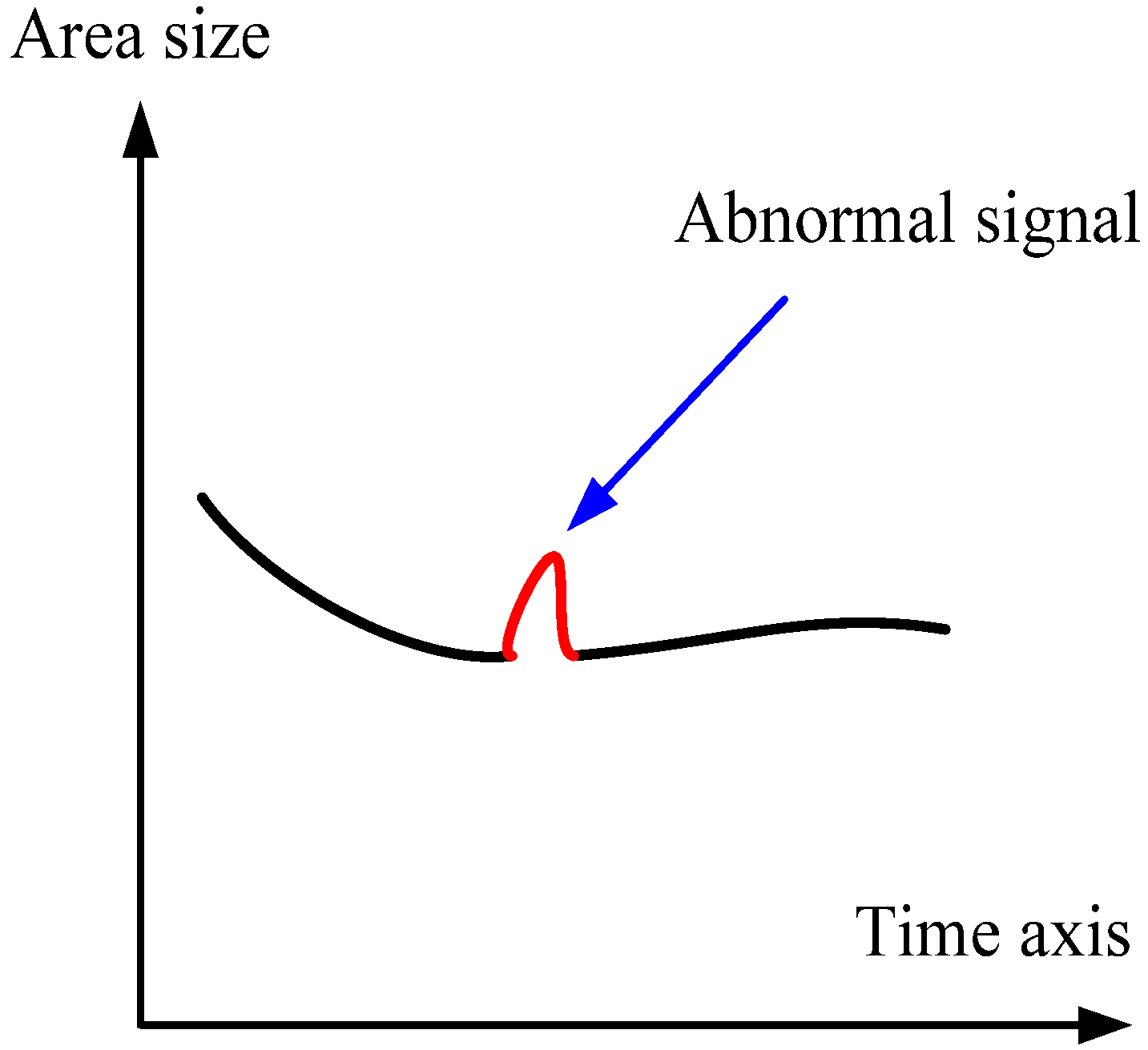
This curvature-based analysis enables the system to detect anomalies in real time and issue early warnings to drivers regarding potential road damage. Figure 2 illustrates the detection process, where the time-series curve of window area size highlights an abnormal signal segment. The red-marked deviation indicates a sudden change in curvature, which the system classifies as a road defect and triggers a warning.
Figure 2.
The curvature detection of the car window.
The overall design of the edge-intelligent vehicle path collaborative monitoring system is based on a combination of a literature review, field surveys, and algorithmic analysis. The system focuses on early-warning monitoring and control of vehicle driving conditions under abnormal road scenarios. The design process evaluates the advantages, limitations, and feasibility of different system architectures, which serve as the foundation for the proposed solution (Figure 3).
Figure 3.
The diagram of the designed system.
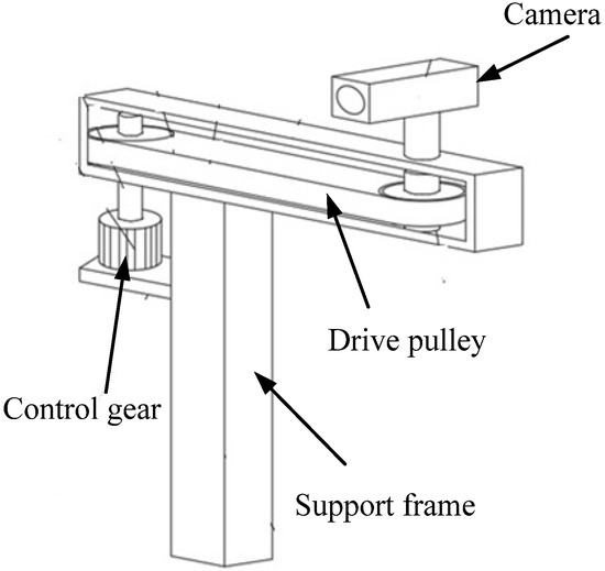
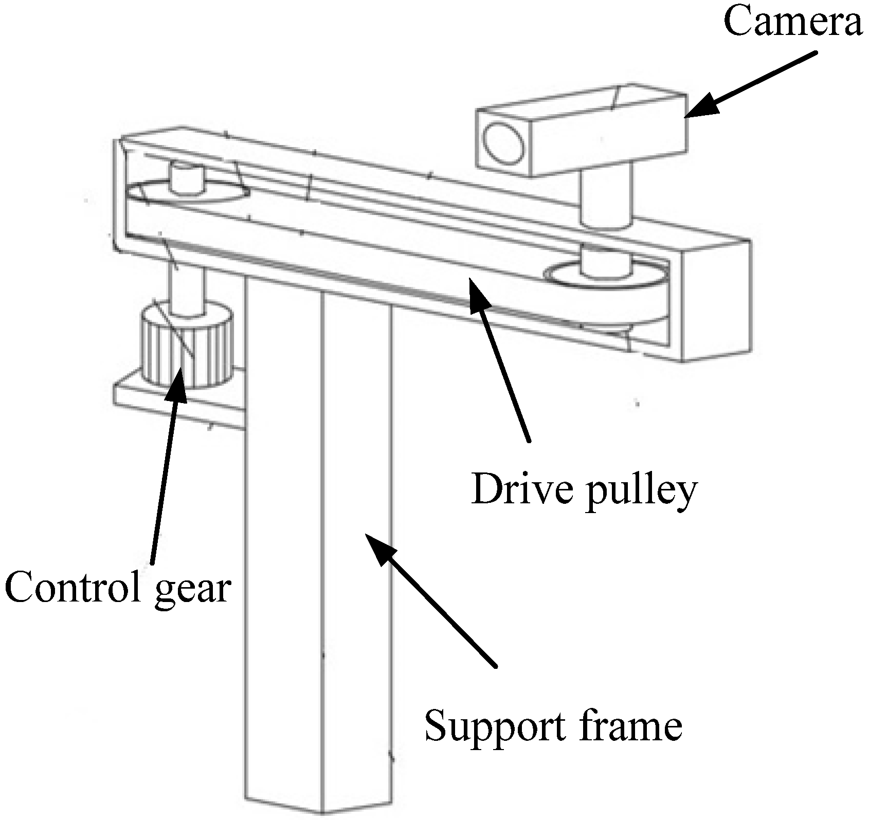
The mechanical structure of the collaborative monitoring system includes an adjustable support mechanism for the monitoring module in the designated shooting range, a connection mechanism, and the framework of the adjustable unit, which were developed through 3D modeling. In addition, we designed the communication protocols and hardware control circuits for the edge device control board, RSU, motor module, vehicle terminal, and wireless data transmission module (Figure 4).
Figure 4.
The mechanical structure of the detector.
The curvature detection component investigates the curve of the car window area. Neural network classification was applied after categorizing car window curve changes associated with ground damage, dents, and foreign objects. Image samples of car windows were collected and preprocessed, with contour information extracted using contour detection algorithms. A convolutional neural network is then constructed to train the car window image data, enabling automatic identification of key parameters such as position, shape, and area. By analyzing variations in curve curvature, the system can issue early warnings regarding potential road abnormalities.
To evaluate the engineering feasibility of the developed system, a comparative analysis was conducted against traditional monitoring architectures that utilize bulky Light Detection and Ranging (LiDAR) and high-end camera setups. The developed edge-intelligent system significantly reduces the financial barrier to entry and enables technical trade-offs as detailed in Table 1.
Table 1.
Engineering comparison of monitoring systems.
4. Discussion
The implementation of the modified CNN architecture, integrated with a Raspberry Pi-based control circuit, demonstrated significant technical improvements over standard monitoring methods. The system achieved a 10% increase in identification accuracy of the vehicle window area by utilizing a depthwise separable convolution architecture. Using the approach, the total number of trainable parameters and computational load are reduced, which is critical for maintaining high feature extraction capabilities on resource-constrained edge devices. Furthermore, the mathematical model for curvature analysis successfully detected surface deviations with a 15% increase in sensitivity compared to traditional threshold-based triggers.
Regarding signal integrity and system reliability, real-time communication between RSU and OBU using the dedicated protocol maintains a packet loss rate of less than 2% under vehicle speeds of 60 km/h. While most conventional vehicles lack integrated cooperative sensing, the high-speed data throughput of this system allows for proactive hazard avoidance. Technical evaluation results in real-world driving environments indicate that the predictive capability of the developed system can reduce potential accident rates by up to 10%, representing a substantial functional upgrade in vehicle-to-infrastructure safety.
From the perspective of human-centric engineering, the developed system enhances driver comfort and safety by 15%, according to performance benchmarks aligned with industry standards. By offloading complex visual processing to the edge (the Raspberry Pi) rather than the cloud, the system minimizes decision latency, ensuring that warnings are issued within the critical reaction window of the driver. Overall, the engineering features developed in this study provide a 10% improvement in economic benefits through reduced hardware costs and lower power consumption. This makes the developed system a robust and reliable alternative for large-scale deployment in smart city infrastructures, proving that high-level safety monitoring is achievable without the high cost of traditional LiDAR-centric systems.
5. Conclusions
In this study, we developed an edge-intelligent vehicle-road collaborative monitoring system that addresses the economic and technical barriers of traditional road defect detection. While conventional methods rely on bulky, high-power (>50 W) LiDAR and cameras, we integrated a Raspberry Pi-based control circuit with an optimized CNN to accurately identify vehicle window area variations. The implementation of depthwise separable convolutions allowed the system to maintain high feature extraction capabilities on resource-constrained hardware, achieving a processing latency of 120 ms, which is a viable trade-off for its significantly lower production cost.
The system adopts a curvature-based mathematical model to detect road abnormalities in real time, transmitting warning signals using a dedicated RSU-OBU protocol with high reliability (a packet loss of <2%). The system reduces hardware costs by 70% compared with that of traditional architectures while improving detection sensitivity and driver safety by 15%. The system also provides a 10% increase in economic benefits and a 10% reduction in potential accident rates through proactive hazard avoidance. It is necessary to reduce equipment dimensions and enhance the robustness of the AI models under diverse weather conditions to facilitate large-scale commercial deployment in smart city infrastructures.
Author Contributions
Conceptualization, W.-H.L.; original draft preparation, F.-C.C.; writing—review and editing, W.-H.L. and F.-C.C. All authors have read and agreed to the published version of the manuscript.
Funding
This research was supported by the Zhaoqing Science and Technology Innovation Guidance Project, project number 241224140090723, and the Research on Vehicle-Road Collaborative Monitoring System Based on Edge Intelligence. Also, the author would like to thank the School of Marine Mechatronics, Xiamen Ocean Vocational College, for its support in the high-level talents research projects under No: KYG202552, which enabled the successful of the project.
Institutional Review Board Statement
Not applicable.
Informed Consent Statement
Not applicable.
Data Availability Statement
All data in the paper were measured by using impartial instruments and then analyzed using mathematical models. There was no act of creating data. No new data were created or analyzed in this study. Data sharing is not applicable to this article.
Conflicts of Interest
The authors declare no conflict of interest.
References
- Raspberry Pi. Available online: https://en.wikipedia.org/wiki/Raspberry_Pi (accessed on 12 December 2025).
- Mertz, C.; Varadharajan, S.; Jose, S.; Sharma, K.; Wander, L.; Wang, J. City-wide road distress monitoring with smartphones. In Proceedings of ITS World Congress; Carnegie Mellon University: Pittsburgh, PA, USA, 2014; pp. 1–9. [Google Scholar]
- Casas-Avellaneda, D.A.; López-Parra, J.F. Detection and localization of potholes in roadways using smartphones. DYNA 2016, 83, 156–162. [Google Scholar] [CrossRef] [Scilit]
- Maeda, H.; Sekimoto, Y.; Seto, T.; Kashiyama, T.; Omata, H. Road damage detection and classification using deep neural networks with smartphone images. Comput. Aided Civ. Infrastruct. Eng. 2018, 33, 1127–1141. [Google Scholar] [CrossRef] [Scilit]
- Chang, H.C. Road Crack Detection Based on Deep Learning. Master’s Thesis, National Taiwan Normal University, Taipei, Taiwan, 2021. [Google Scholar]
- Chen, S.Y. Wide-Channel-Based Fully Convolutional Network for Road Detection. Master’s Thesis, National Formosa University, Huwei, Taiwan, 2020. [Google Scholar]
- Yousaf, M.H.; Azhar, K.; Murtaza, F.; Hussain, F. Visual analysis of asphalt pavement for detection and localization of potholes. Adv. Eng. Inform. 2018, 38, 527–537. [Google Scholar] [CrossRef] [Scilit]
- Hui, B.; Guo, M.; Wanget, Z.; Tsai, Y. Multi-dimensional index detection of potholes based on 3D laser technology. J. Tongji Univ. 2018, 46, 60–66. [Google Scholar]
- Alvarez, J.M.Á.; Ĺopez, A.M. Road detection based on illuminant invariance. IEEE Trans. Intell. Transp. Syst. 2010, 12, 184–193. [Google Scholar] [CrossRef] [Scilit]
- Huo, N. Research and Implementation of Road Detection System Based of Mobile Intelligent Terminal. Master’s Thesis, Xi’an University of Technology, Xi’an, China, 2018. [Google Scholar]
- Asmiatun, S.; Wakhidah, N.; Putr, A.N. Road surface automatic identification system with combination pothole detection method and Z-Diff method on android smartphone. In Proceedings of the Joint Workshop KO2PI and the 1st International Conference on Advance & Scientific Innovation; European Alliance for Innovation (EAI): Ghent, Belgium, 2018; pp. 39–46. [Google Scholar]
- Anaissi, A.; Khoa, N.L.D.; Rakotoarivelo, T.; Alamdari, M.M.; Wang, Y. Smart pothole detection system using vehicle-mounted sensors and machine learning. J. Civ. Struct. Health Monit. 2019, 9, 91–102. [Google Scholar] [CrossRef] [Scilit]
- Huang, C.Y. High Efficiency Sensing Technology for Road Surface Detection in Nighttime. Master’s Thesis, National Chung Hsing University, Taichung, Taiwan, 2016. [Google Scholar]
- Pena-Caballero, C.; Kim, D.; Gonzalez, A.; Castellanos, O.; Cantu, A.; Ho, J. Real-time road hazard information system. Infrastructures 2020, 5, 75. [Google Scholar] [CrossRef] [Scilit]
- Yang, D.P. Research and Development of Cooperative Vehicle Infrastructure Monitoring System Based on Intelligent Terminal. Master’s Thesis, Chongqing University, Chongqing, China, 2021. [Google Scholar]
- Dong, X.H. Research on Vehicle-Mounted Road Abnormality Detection and Positioning System. Master’s Thesis, Chang’an University, Xi’an, China, 2022. [Google Scholar]
- Yuan, L.Y. Research on Road Defect Detection and Risk Assessment for Autonomous Driving Scenarios. Master’s Thesis, Guangxi University, Nanning, China, 2024. [Google Scholar]
- Lang, A.H.; Vora, S.; Caesar, H.; Zhou, L.; Yang, J.; Beijbom, O. PointPillars: Fast Encoders for Object Detection from Point Clouds. In Proceedings of the IEEE/CVF Conference on Computer Vision and Pattern Recognition (CVPR), Long Beach, CA, USA, 16 June 2019; Available online: https://openaccess.thecvf.com/content_CVPR_2019/papers/Lang_PointPillars_Fast_Encoders_for_Object_Detection_From_Point_Clouds_CVPR_2019_paper.pdf (accessed on 16 June 2019).
- Waymo. Available online: https://waymo.com/research/streaming-object-detection-for-3-d-point-clouds/ (accessed on 13 March 2026).

Disclaimer/Publisher’s Note: The statements, opinions and data contained in all publications are solely those of the individual author(s) and contributor(s) and not of MDPI and/or the editor(s). MDPI and/or the editor(s) disclaim responsibility for any injury to people or property resulting from any ideas, methods, instructions or products referred to in the content. |
© 2026 by the authors. Licensee MDPI, Basel, Switzerland. This article is an open access article distributed under the terms and conditions of the Creative Commons Attribution (CC BY) license.