


Abstract
Autonomous platforms are critical for accelerating disaster response by delivering situational awareness and search-and-rescue support without exposing human operators to risk. However, practitioners face significant challenges in selecting and implementing robust software on vendor-constrained, immutable hardware. This paper provides a comprehensive survey contrasting the capabilities of two complementary unmanned platforms: Unmanned Aerial Vehicles (UAVs) and Unmanned Ground Vehicles (UGVs). We analyze state-of-the-art software blueprints for perception, navigation, and coordination under the constraints of fixed hardware. Key contributions include a comparative analysis of mission suitability, a synthesis of emerging machine learning algorithms for robust navigation, and an identification of critical research gaps. While recent works have advanced specific algorithms, a comprehensive survey comparing software-driven approaches on fixed-hardware UAVs and UGVs is lacking, a gap this paper aims to fill. Our analysis reveals that the sim-to-real transfer gap, the absence of standardised disaster benchmarks, and limited explainability of deep-reinforcement-learning policies remain the most critical barriers to field deployment. We conclude with a prioritised research roadmap that groups open challenges into short-term (1–2 year) and long-term (3–5+ year) directions.
1. Introduction
Disasters like floods, landslides, wildfires, and earthquakes pose serious and complicated problems. Responding quickly and understanding what is really going on is absolutely essential [1]. Autonomous robotic platforms have emerged as invaluable assets for disaster response, performing critical tasks such as reconnaissance, victim detection, payload delivery, and infrastructure assessment [2,3,4,5]. Their ability to operate without risking human lives makes them indispensable in hazardous environments where conventional access is limited or unsafe.
The adoption of these platforms is rapidly growing, as shown in Figure 1, which illustrates the market expansion in this sector. This survey focuses on two complementary unmanned platform types: aerial systems (Unmanned Aerial Vehicles, UAVs) and ground vehicles (Unmanned Ground Vehicles, UGVs). Unlike many academic surveys that explore custom or experimental hardware [6], this work specifically considers platforms constrained to vendor-supplied, immutable hardware configurations, reflecting common real-world deployment scenarios [7]. Such constraints emphasize the necessity for advanced, software-driven approaches to maximize autonomous capabilities within fixed sensor suites, compute budgets, and power limitations. In practice, vendor lock-in means that performance bottlenecks caused by suboptimal sensor placement, limited onboard compute, or restricted communication interfaces cannot be resolved through hardware modification; every gain must come from smarter algorithms, more efficient data pipelines, and modular software architectures.
Figure 1.
The market growth and share of autonomous platforms in disaster response.
Recent advances have propelled the frontier of disaster reconnaissance software. High-frequency LiDAR-inertial odometry (LIO) pipelines deliver robust pose estimation on resource-constrained embedded processors [8,9]. Distributed localization and simultaneous mapping (SLAM) enable multi-robot coordination even with intermittent communication [10]. Deep reinforcement learning (DRL) techniques enhance navigation and obstacle avoidance in complex, dynamic environments [11,12]. Energy-aware scheduling and mission planning optimize limited UAV flight times and UGV endurance for extended operations [13,14].
Despite significant progress, formidable challenges remain. Limited flight endurance for UAVs restricts continuous coverage [15], while UGV mobility faces mechanical constraints to obstacle clearance and rugged terrain navigation [1,16]. Sensor degradation in adverse conditions such as smoke, dust, or low light demands multimodal fusion and sensor-agnostic algorithms [6,17]. Regulatory and ethical considerations, including data privacy and operational safety, require careful attention [18]. Furthermore, there is a pressing need for standardized datasets and benchmarking environments to enable objective performance comparison and accelerate innovation [19].
By synthesizing a diverse range of peer-reviewed works, this survey offers an up-to-date, vendor-agnostic software blueprint tailored for autonomous disaster reconnaissance missions. It aims to guide researchers and practitioners in selecting, adapting, and advancing software methodologies that make the most of fixed hardware platforms.
1.1. Aims and Motivation (UAV & UGV)
The primary objective of this section is to examine software pipelines that strengthen UAV autonomy when sensor configuration, compute power, and communication interfaces are fixed by the manufacturer. Many commercial UAVs offer only a small set of integrated sensors, often with restricted access to low-level controls. This motivates the need for lightweight perception, mapping, and scheduling algorithms that preserve mission performance despite limited onboard resources. By consolidating recent advancements, this survey assists practitioners in selecting techniques that enable UAVs to operate effectively in dynamic, time-critical disaster environments.
1.2. Contributions
The specific contributions of this paper are:
- A novel comparative analysis of UAV and UGV platforms focused on software solutions for fixed hardware, rather than on hardware design.
- A synthesis and categorization of current and emerging machine learning algorithms, particularly deep reinforcement learning, for robust navigation in disaster environments.
- A comprehensive classification framework for recent literature, highlighting key trends, research gaps, and platform-specific challenges.
- A curated bibliography of over 100 recent academic sources (2018–2025) relevant to the field.
To highlight the unique positioning of our work, Table 1 provides a detailed comparison between this survey and recent review literature. It outlines key differentiating factors such as platform focus, the extent of machine learning coverage, and the consideration of fixed hardware constraints. This comparison demonstrates how our survey bridges existing gaps by offering a comprehensive, software-centric analysis of both UAVs and UGVs in disaster reconnaissance.
Table 1.
Comparison of Survey Papers by Scope and Coverage.
2. UAV-Based Autonomous Reconnaissance
UAVs play an important role in early-stage disaster assessment because they can rapidly access areas that are unsafe or unreachable for ground robots [21]. Their deployment remains constrained by short flight endurance and limited payload capacity, which restrict the sensing and compute modules that can be carried during reconnaissance missions [14]. Perception reliability is also affected by smoke, dust, and adverse weather, which degrade sensor performance and increase localization uncertainty [22]. These constraints make software-centric improvements—rather than hardware modifications—essential for achieving robust autonomous navigation in real-world disaster environments [23].
2.1. Platform Constraints and Typical Performance
Typical rotary-wing UAVs include a camera, IMU, barometer, and in some cases a compact LiDAR. Their short endurance requires algorithms that minimize computation and power consumption, since flight time often remains the limiting factor for reconnaissance missions [14]. Payload restrictions prevent adding heavier sensors, and embedded processors limit the complexity of onboard inference. As a result, real-time execution must remain efficient and tightly optimized for low-power hardware.
2.2. Sensing and Perception
Modern perception pipelines increasingly utilize compact LiDAR-inertial odometry frameworks to maintain pose accuracy under aggressive motion or partial visibility. Super-LIO improves mapping efficiency through a compact voxel strategy suitable for low-cost UAV hardware [8]. LIO-EKF employs a tightly coupled Kalman-filter formulation to stabilize pose estimation in environments with vibration and motion disturbances [9]. Sensor-agnostic odometry further improves robustness by reducing dependence on specific LiDAR characteristics or calibration assumptions [17,24]. For victim detection, lightweight YOLO-based models are deployed onboard and optimized for low-power processors, supporting real search-and-rescue operations where onboard inference is needed [25].
2.3. Localization, Mapping, and Multi-Robot Coordination
UAV localization in GNSS-denied zones relies on tightly coupled LiDAR-IMU pipelines such as LIO-SAM, which maintain low drift in smoke or dust-filled environments [16]. Multi-UAV systems use distributed relative localization to share pose estimates and map fragments during cooperative exploration, enabling more complete environment coverage under intermittent communication [10]. Multi-objective planning frameworks balance visibility, obstacle avoidance, and energy consumption to support mission-aware path generation in cluttered spaces [26,27,28,29,30].
2.4. Typical Mission Profiles and Metrics
UAVs in disaster-response missions conduct aerial sweeps, structural mapping, and thermal or visual search for victims. Mission success depends on factors such as drift accumulation, communication quality, and wind-resilience. Since flight time is limited, mission planners often prioritize rapid coverage over long-duration hovering. For multi-UAV deployments, metrics such as inter-robot separation, relative-localization accuracy, and cooperative coverage ratio are used to allocate tasks efficiently. Table 2 summarises the typical mission metrics, performance ranges, and hardware constraints for UAV platforms deployed in disaster reconnaissaince.
Table 2.
Typical UAV Mission Metrics.
2.5. Open Challenges (UAV)
- Perception robustness: Low-texture, smoke, or night conditions can significantly degrade camera and LiDAR performance, reducing detection reliability [36].
- Energy planning: Flight-time limits constrain how much onboard computation and sensing a UAV can run during a mission [14]. Mission planners therefore need to schedule compute tasks and design search patterns that use the available battery budget efficiently [35].
- Communication resilience: Lossy wireless links in cluttered or partially collapsed environments reduce bandwidth and cause intermittent connectivity [10]. These conditions motivate distributed localization and higher levels of onboard autonomy so UAVs can continue operating even when communication drops out [37].
- Hardware transparency: Limited access to vendor hardware specifications and low-level APIs makes it difficult to tune algorithms and systematically benchmark autonomy stacks across platforms [38].
Figure 2 summarizes the primary challenges affecting UAV-based autonomous disaster reconnaissance. Adverse environmental conditions, including smoke, dust, low illumination, and wind, degrade perception reliability and increase localization uncertainty. Energy constraints imposed by limited battery capacity restrict mission duration and onboard computation, necessitating careful scheduling of sensing, inference, and communication tasks. In addition, wireless connectivity is frequently intermittent in cluttered or partially collapsed environments, reducing bandwidth and reliability. These combined limitations reinforce the need for software-centric autonomy frameworks that optimize perception, localization, and mission planning within vendor-restricted hardware platforms.
Figure 2.
“Challenges in UAV-Based Autonomous Reconnaissance” diagram.
2.6. Ethical, Legal, and Social Implications (UAV)
Autonomous UAV operations in disaster zones raise important ethical and legal questions. Privacy protection remains a major concern because aerial imaging frequently captures civilians and sensitive infrastructure during rapid-response missions [37]. Regulatory constraints also limit operational flexibility; restrictions on night flights, altitude, and BVLOS navigation apply even during emergencies, requiring strict adherence to national aviation rules [36].
Communication security is another critical issue. UAVs rely on wireless links for telemetry and video streaming, and these channels are vulnerable to interference or interception, which can compromise mission safety [10,39,40]. Public acceptance further affects deployment, as communities often express concerns about surveillance and the use of autonomous decision-making systems [38].
Finally, the growing role of onboard autonomy raises questions of responsibility and accountability when system errors occur. Ensuring transparent algorithm design and clear operational protocols is essential for maintaining trust in UAV-based disaster response [23].
3. UGV-Based Autonomous Reconnaissance
3.1. Platform Specifications
Unmanned Ground Vehicles (UGVs) used in disaster-response missions are designed to operate in rubble, collapsed structures, tunnels, and uneven outdoor terrain where aerial platforms cannot function safely. Their mobility advantages come from rugged chassis designs, track-based locomotion, articulated flippers, and high-torque drivetrains that support obstacle negotiation under harsh conditions. Studies evaluating multi-tracked and flipper-based running gear show that track geometry, suspension, and contact surface design directly determine a UGV’s ability to climb debris piles and unstable surfaces [41]. More recent work demonstrates that optimizing running-gear construction improves stability when traversing high-mobility or deformable terrain [26,42,43,44,45].
UGVs typically carry heavier sensing payloads than UAVs, enabling richer perception pipelines. Common modules include LiDAR, radar, stereo camera rigs, ultrasonic sensors, and thermal cameras, all of which help maintain situational awareness in obscured environments such as dust, smoke, or darkness [22]. Navigation robustness is further improved through multi-sensor fusion frameworks that combine radar, LiDAR, and optical cues for consistent localization even when individual modalities degrade [22].
Despite their mechanical robustness, UGVs face several hardware constraints. Power consumption increases sharply when climbing or turning on rough terrain, limiting mission duration in long deployments [46]. Ground robots must also manage wheel/track slip, traction loss, and vibration-induced sensor noise when operating in unstable areas, making terrain-adaptive control and energy-aware motion planning essential for reliable field performance [18]. Additionally, real-world deployments highlight that even well-engineered UGVs exhibit reduced efficiency in granular surfaces, steep inclines, and cluttered indoor environments, reinforcing the need for mobility-aware planning and robust perception pipelines [16].
Together, these studies show that UGV hardware design directly affects mobility, sensing reliability, and mission endurance in disaster reconnaissance tasks. This has led recent research to prioritize improved locomotion mechanisms, power-efficient navigation strategies, and resilient multi-modal perception to ensure operational reliability in unpredictable field conditions.
3.2. Mobility and Obstacle Negotiation
UGV mobility in disaster environments depends strongly on locomotion design, especially when navigating rubble, steep inclines, or deformable terrain. Multi-tracked and flipper-equipped systems demonstrate significantly better obstacle negotiation due to increased ground contact area and adaptable geometry [41]. Additional studies show that running-gear construction directly impacts traversal speed and stability when crossing debris, ditches, or collapsed flooring [26].
Tracked vehicles remain the most common choice for disaster-response UGVs because they distribute pressure evenly and reduce the risk of sinking into soft or granular terrain. Terrain-aware path-planning techniques further compensate for slippage, loss of traction, and vibration-induced instability, improving both navigation accuracy and energy efficiency during extended missions [18,47,48]. These mobility-focused investigations highlight that mechanical design, and motion-planning strategies must be jointly optimized to ensure robust performance in unpredictable real-world field conditions [16].
3.3. Sensing, Localization, and Perception
Reliable perception is essential for UGV operation in collapsed structures or low-visibility zones. Modern UGVs typically integrate LiDAR, radar, thermal cameras, ultrasonic sensors, and stereo vision to support obstacle detection, mapping, and target identification. Multimodal sensing pipelines increase robustness because each sensor offers complementary strengths; for example, radar works in smoke and dust where optical sensors fail, while LiDAR provides detailed geometric structure [22].
Localization accuracy improves significantly when sensors are tightly coupled using fusion frameworks such as LiDAR-Inertial Odometry (LIO-EKF) pipelines [16]. These architectures mitigate drift by combining high-frequency inertial data with geometric LiDAR constraints, enabling stable navigation even under vibration. Recent research also emphasizes resilience under hazardous conditions, showing that multimodal fusion is essential for reliable perception when sensors degrade due to shock, dust, or surface reflections [49]. Together, these findings illustrate that UGV perception must be both multi-sensor and fault-tolerant to support real disaster-site deployments.
3.4. Typical Mission Metrics
UGV deployments in disaster environments rely on durable mobility systems, robust sensing suites, and stable navigation performance under harsh terrain conditions. Their operational capability depends on factors such as track-terrain interaction, vibration resistance, and power consumption during obstacle negotiation [41]. Mechanical design choices-including multi-tracked running gear, flippers, and suspension systems-directly influence a platform’s ability to traverse rubble, steep inclines, or deformable ground surfaces [16]. Onboard perception modules such as LiDAR, radar, and thermal sensors support navigation in low-visibility or cluttered environments, while multimodal fusion improves reliability when single sensors degrade [49]. Table 3 summarizes these hardware configurations and performance characteristics, highlighting how different UGV designs balance mobility, sensing, and stability to achieve consistent operation in disaster-response missions [50].
Table 3.
Typical UGV Mission Metrics.
3.5. Open Challenges (UGV)
Terrain modeling: Predicting slip and sinkage on rubble remains open [16,55].
Power consumption: Tracked locomotion demands careful battery management [46].
Sensor integration: Multi-modal sensors generate high data rates, requiring optimized fusion pipelines [56].
Standardized testing: Lack of standardized disaster testbeds hinders comparison [19].
Figure 3 illustrates these primary open challenges affecting UGV-based disaster reconnaissance.
Figure 3.
“Challenges in UGV-Based Disaster Reconnaissance” diagram.
3.6. Integration of Perception, Localization, and Motion Control
UGV autonomy relies on the tight integration of sensing, mapping, and control subsystems. Localization pipelines such as LIO-EKF combine inertial and LiDAR data to maintain accurate pose tracking during high-vibration locomotion or when GPS is unavailable [16]. These pose estimates are fused with terrain-aware perception modules that detect obstacles, classify surface types, and identify traversable paths using multimodal sensing [22].
Motion-control systems then convert perception and localization outputs into stable movement decisions. Terrain-aware controllers adjust velocity, track torque, and flipper angles to compensate for slip or instability on uneven terrain [18]. Power-optimized control frameworks further reduce energy consumption during long-duration missions by minimizing unnecessary corrective movements [46,57,58].
Together, this integration enables UGVs to operate reliably in cluttered, unpredictable disaster environments where single-module failures would otherwise disrupt navigation.
Localization pipelines such as LIO-EKF rely on Kalman-filter update principles summarized in Equations (4) and (5).
3.7. Ethical, Legal, and Social Implications (UGV)
UGV deployments raise several ethical and social considerations. Ground robots often operate close to civilians, collecting detailed structural, thermal, and environmental data that may contain sensitive information [59]. Maintaining secure data-handling pipelines is therefore essential, especially when robots operate in partially accessible public spaces. Social acceptance depends heavily on predictable, safe behavior, since the proximity of a large ground robot can cause discomfort or perceived risk to bystanders [60,61,62]. Effective human–robot interaction—such as clear signaling, slow approach behavior, and intuitive teleoperation interfaces—helps mitigate these concerns.
Operational safety is another critical dimension. UGVs must navigate rubble, narrow corridors, and partially collapsed structures without risking secondary collapse. Ethical frameworks emphasize minimizing physical risk, ensuring that autonomy modules cannot initiate dangerous maneuvers in confined spaces [56]. Finally, clear accountability protocols are required when robots operate semi-autonomously; organizations must determine responsibility for system failures, data mismanagement, or unintended harm [63].
4. Comparative Analysis and Design Implications
4.1. Mission Suitability
UGV mobility depends heavily on mechanical design, track geometry, and ground interaction models. Recent work shows that multi-tracked and articulated running gear significantly improves stability when traversing rubble, voids, or steep inclines [41]. High-mobility tracked platforms also benefit from suspension systems that reduce slip and maintain ground contact on deformable terrain [16]. Several studies emphasize that obstacle-negotiation performance directly correlates with chassis geometry, contact length, and track-soil mechanics, making UGV mobility largely dependent on low-level mechanical design rather than software-only interventions [22].
In contrast, UAV mobility is governed by aerodynamic efficiency and power budget. Their flight envelope becomes especially constrained in wind, smoke, or confined spaces, where disturbances degrade positioning accuracy and increase energy consumption. Surveys on UAV endurance show that battery limitations remain a dominant bottleneck, with endurance rarely exceeding 30–45 min under load [14]. Consequently, mobility comparisons highlight a trade-off: UGVs achieve persistent operation but are slowed by terrain roughness, while UAVs achieve rapid coverage but are limited by energy and environmental instability.
Table 4 provides a side-by-side comparison of UAV and UGV capabilities in disaster-response settings, highlighting how each platform’s strengths and limitations shape their operational roles. UAVs excel in aerial coverage, rapid deployment, and access to hazardous or unreachable zones, but remain constrained by short flight duration, limited payload capacity, and sensor instability in turbulent or smoke-filled environments [14]. UGVs offer sustained operation, high payload support, and robustness in degraded visibility, aided by terrain-adaptive mobility systems and multimodal sensing suites [16,22,41]. The table synthesizes findings across recent literature to illustrate that UAVs are preferred for fast situational assessment, while UGVs are better suited for long-duration tasks requiring stability, heavy sensing hardware, or close-range interaction with the environment.
Table 4.
Comparative Analysis: UAV vs. UGV.
4.2. Engineering Trade-Offs
Perception systems across UAVs and UGVs rely on multimodal sensing-LiDAR, radar, RGB, thermal, and inertial measurements—to maintain situational awareness in degraded environments. Recent LiDAR-IMU odometry research demonstrates that tightly coupled fusion pipelines (such as LIO-SAM and LIO-EKF variants) reduce drift and improve mapping consistency even in dusty, smoky, or low-texture settings [8,9,17]. UGV-focused studies show that radar and LiDAR remain reliable in subterranean, foggy, or cluttered spaces where optical sensors fail [50]. These findings underline the importance of redundancy: perception reliability increases significantly when multiple sensing modalities compensate for each other’s weaknesses.
UAVs, however, face higher perception failure rates due to altitude-dependent motion blur, vibration, and rapid lighting changes. Energy constraints also limit the size and payload of onboard sensors, restricting UAVs to lightweight cameras and compact LiDAR units [14]. UGVs avoid these payload constraints and can mount heavier sensors, including thermal imagers and long-range LiDAR, allowing them to sustain perception quality across longer missions. Comparative analysis consistently shows that UGV sensing suites provide more stable perception than UAVs, especially in dark, dusty, or confined environments [22].
4.3. Emerging Robotic Modalities
UAVs rely heavily on precise localization and tight inertial fusion due to their sensitivity to drift and instability during flight. Studies in UAV autonomous navigation highlight the importance of privileged sensing and model-dependent optimization to maintain stable control in cluttered or GPS-denied environments [11]. Reinforcement-learning-based approaches have shown promise for rapidly adapting flight behavior in dynamic scenes, but they continue to struggle with sim-to-real transfer and unpredictable wind disturbances [67]. UAV controllers therefore tend to combine classical control loops with learned policies to improve robustness without sacrificing stability.
UGVs follow a different autonomy pattern. Their control architectures can tolerate slower update rates and higher latency because the platform is grounded and mechanically stable. Research on flipper-based and multi-tracked UGVs shows that terrain-adaptive motion planning improves success rates on rubble and steep slopes [16]. Additional work demonstrates that UGV autonomy benefits from multimodal SLAM, radar-enhanced odometry, and robust local planning frameworks capable of re-routing around blocked passages [50].
The comparative trend across recent literature is clear: UAV autonomy must prioritize rapid response and energy-efficient motion optimization, while UGV autonomy emphasizes stability, terrain reasoning, and multimodal sensing. Both domains increasingly adopt DRL-based policies for decision-making, but implementation challenges differ due to platform constraints and environmental interactions [56].
5. Machine Learning and Software Algorithms for UAV & UGV
Machine-learning methods increasingly serve as the core intelligence layer for autonomous UAV and UGV systems, allowing fixed-hardware platforms to achieve higher levels of perception, planning, and decision-making than traditional algorithms alone can provide [68]. Modern disaster-response robots rely on learning-based mapping, detection, and control modules to operate in conditions where classical pipelines fail-such as GPS-denied zones, degraded visibility, cluttered debris fields, and rapidly changing environments. These algorithms also enable robust data fusion across multiple sensing modalities, supporting tasks like terrain understanding, victim detection, and long-horizon navigation. Importantly, software-driven improvements are independent of vendor-restricted hardware, making them essential for field robots that cannot be physically modified. The subsections that follow describe how machine-learning approaches strengthen key autonomy components, covering multimodal detection, deep reinforcement learning, advanced UGV control, and integration into multi-robot systems.
5.1. Multi-Modal Detection and Victim Detection
Search-and-rescue missions require reliable sensing under debris, smoke, darkness, and occlusion. Multi-modal learning methods combine thermal imagery, RGB video, LiDAR signatures, and acoustic signals to detect victims more robustly. Neural networks trained on aerial imagery and thermal cues improve the detection of human silhouettes under partial occlusion, especially in low-light environments [69].
Audio-based learning models assist drones in identifying cries for help or impact noises. Because rotor noise masks weak acoustic signals, CNN-based denoising models are trained to suppress drone motor frequencies and isolate human-generated sounds [70]. Direction-of-Arrival (DoA) estimation further helps localize survivors by computing bearing angles from multi-microphone arrays [70,71].
Thermal-acoustic-visual fusion has been shown to significantly improve victim detection performance compared with single-modality approaches, particularly when camera visibility degrades due to dust or fog [72]. Lightweight detectors like SSD MobileNet V3 have also been deployed on embedded UAV hardware, achieving real-time human identification on Raspberry Pi-based quadcopters with modest accuracy but consistent frame rates suitable for rapid scanning [25].
Beyond environmental perception, autonomous disaster robots must also detect human survivors in cluttered, low-visibility scenes. Lightweight convolutional models deployed on edge hardware enable real-time victim identification from UAV video feeds without relying on cloud connectivity [69]. Audio-visual fusion pipelines further improve detection reliability by combining thermal signatures with acoustic cues, which is particularly valuable when victims are obscured by debris or smoke [17]. These detection capabilities build directly on the multi-modal perception pipelines described above, as reliable victim identification depends on robust sensor preprocessing, noise filtering, and feature extraction under adverse conditions.
5.2. Deep Reinforcement Learning for Navigation
Deep reinforcement learning (DRL) enables robots to navigate dynamic, partially observable environments by learning policies that map sensor inputs directly into actions. DRL supports both UAV and UGV autonomy in complex terrains where classical planners struggle with noise, obstacles, or motion uncertainty.
Distributed Privileged Reinforcement Learning (DPRL) demonstrates how asymmetric Actor-Critic architectures can exploit rich simulation data while deploying lightweight policies on real UAVs [11]. For ground platforms, adaptive speed-planning models have used Deep Q-Networks (DQN) and Double-DQN to regulate motion over uneven terrain, reducing slippage and improving obstacle avoidance [12].
To meet the expanding needs of autonomous navigation, several other DRL algorithms are actively researched:
- Proximal Policy Optimization (PPO): Widely used for its stable training and good performance, PPO [66] is effective for continuous control tasks like UAV navigation, balancing exploration and exploitation. PPO’s clipped surrogate objective prevents destructively large policy updates, making it particularly suitable for disaster scenarios where a UAV or UGV must maintain stable behaviour mid-flight or mid-traversal; an unstable update could cause a crash in rubble or loss of altitude in smoke-filled airspace [51,66,67].
- Asynchronous Advantage Actor-Critic (A3C): A3C [46] uses parallel agents to explore the environment, speeding up training and improving policy robustness, which is critical for time-sensitive disaster missions.
- Deep Deterministic Policy Gradient (DDPG): DDPG [73] is an off-policy algorithm well-suited for continuous action spaces, such as precise UGV steering or UAV velocity control. Although DDPG pioneered continuous-action DRL for robotics, its single-critic architecture makes it sensitive to overestimation, which motivates the TD3 and SAC improvements discussed below. In disaster settings, DDPG remains relevant for low-dimensional control tasks such as single-actuator steering on tracked UGVs [73].
- Twin-Delayed DDPG (TD3): TD3 [52] improves upon DDPG by addressing Q-value overestimation, leading to more stable policies and better performance in complex navigation tasks. By maintaining twin critics and selecting the more conservative Q-value estimate, TD3 reduces the overestimation bias that can cause aggressive, collision-prone manoeuvres—a critical safety property for ground robots navigating narrow, debris-filled corridors where a single collision may immobilise the platform [73,74].
- Soft Actor-Critic (SAC): This algorithm [22] optimizes maximum entropy, encouraging exploration and resulting in highly robust policies that can better handle unexpected environmental changes, a common feature of disaster zones. SAC’s maximum-entropy framework explicitly rewards policy randomness, which encourages the agent to explore diverse locomotion strategies—an advantage when a UGV encounters novel rubble configurations not seen during training. However, practitioners should note that entropy-regularised policies may require careful reward-shaping to avoid excessively cautious behaviour in time-critical rescue missions [75].
- Model-Based RL (e.g., PlaNet): Algorithms like PlaNet [67] learn a model of the world, allowing the agent to “imagine” future scenarios. This is invaluable for power-constrained UAVs, as it can optimize long-horizon paths for energy efficiency.
- Multi-Agent RL (MARL): MARL frameworks [76,77] are essential for coordinating swarms of UAVs or mixed UAV-UGV teams, optimizing collective objectives like maximizing search coverage. In disaster reconnaissance, communication infrastructure is often destroyed; MARL frameworks that operate under decentralised execution with centralised training (CTDE) are therefore essential, as they allow each robot to act on local observations while the training phase leverages a shared critic with global state access [76,77].
- Hierarchical RL (HRL): HRL [78] breaks down complex tasks (e.g., “search building”) into sub-goals (e.g., “enter door,” “scan room”), making long-horizon planning more tractable.
- Curriculum Learning (CL): CL [79] trains agents on progressively harder tasks, improving sample efficiency and the final policy’s ability to handle difficult navigation challenges.
- Sim-to-Real Transfer: A major focus is using techniques like domain randomization [80] to train policies in simulation and deploy them on real robots with minimal fine-tuning. Domain randomisation and progressive transfer are discussed in detail in Section 6.3; here we note that disaster environments amplify the sim-to-real gap because simulation engines rarely model stochastic factors such as drifting smoke, partial structural collapse, or water intrusion [74,80].
Together, these methods demonstrate that DRL is becoming a central component in high-level autonomy for both aerial and ground robotic systems operating in unstable conditions.
The mathematical objectives underlying these methods are summarized in Equations (1)–(3).
5.3. Advanced Path Planning and Control for UGVs
UGVs require robust control policies for navigating rubble, steep gradients, soft soil, or uneven terrain. Traditional control strategies often struggle with abrupt friction changes or slipping surfaces, motivating the development of learning-enhanced planners and adaptive controllers.
A 2025 study in Sensors proposes a second-order sliding-mode controller designed to regulate UGV motion under rapid terrain transitions, demonstrating improved stability and reduced tracking error in rough outdoor conditions [66]. Meanwhile, a study in Frontiers in Neurorobotics introduces an end-to-end navigation architecture that fuses attention mechanisms with recurrent neural networks (RNNs) to predict feasible trajectories based on real-time sensor feedback [81].
Other approaches include hybrid architectures that couple DRL-based high-level planners with classic low-level controllers, allowing UGVs to maintain both reactivity and robustness when operating in collapsed structures or densely obstructed environments [16]. These advances highlight the shift toward adaptive, learning-enhanced control schemes that improve reliability for long-duration UGV deployments.
5.4. Multi-Robot Coordination: Swarms and Distributed Systems
Deploying the perception, learning, and planning modules described in Section 5.1, Section 5.2 and Section 5.3 on individual robots is necessary but insufficient for large-scale disaster response. Real-world missions increasingly require coordinated multi-robot teams that share situational awareness, distribute tasks, and maintain formation despite degraded communication. This section examines the coordination architectures that integrate individual-robot capabilities into scalable, collaborative systems.
Disaster environments often exceed the sensing range, endurance, and operational capacity of a single robotic platform. As a result, recent research increasingly emphasizes multi-robot systems in which heterogeneous teams of UAVs and UGVs collaborate to improve coverage, robustness, and mission efficiency. Swarm-based and distributed architectures enable robots to share situational awareness, distribute workload, and maintain operational continuity even when individual agents fail or communication becomes intermittent. Within disaster-response scenarios, such coordination is particularly valuable for rapid area exploration, resilient communication, and cooperative perception across air-ground teams.
5.4.1. Distributed Relative Localization
Effective coordination in multi-robot systems requires each robot to maintain awareness of its teammates’ relative positions to avoid collisions and support cooperative task execution. In disaster environments where GNSS signals are unavailable or unreliable, robots cannot depend on global positioning and must instead rely on distributed relative localization techniques. Wang et al. survey a wide range of distributed relative localization algorithms designed for multi-robot networks, highlighting approaches that rely on onboard sensing and inter-robot measurements rather than centralized infrastructure [10].
These methods typically employ ranging sensors such as ultra-wideband (UWB), visual fiducials, or bearing measurements to construct a relative pose graph that captures the geometric relationships among robots. Barycentric coordinate-based localization and consensus-driven estimation allow the swarm to maintain a shared coordinate frame without the need for a central master node, improving resilience against communication dropouts or individual robot failures [10,82,83,84]. In disaster-response missions, such decentralized localization frameworks enable UAVs and UGVs to coordinate exploration, share map fragments, and maintain safe separation even under intermittent connectivity.
5.4.2. Mesh Networking and Communication Recovery
Beyond sensing and mobility, communication infrastructure plays a critical role in multi-robot disaster-response systems. UAVs are increasingly deployed not only as sensing platforms but also as airborne communication relays that extend network coverage over damaged or obstructed areas. Recent studies on UAV-assisted mesh networking demonstrate how aerial swarms can form temporary wireless backbones to support coordination among ground robots and human operators during emergency response operations [32,37,85,86].
In this flying base-station paradigm, UAVs dynamically position themselves to maintain line-of-sight links, creating ad hoc Wi-Fi or long-range communication networks that compensate for damaged terrestrial infrastructure. Such networks enable real-time data exchange between UAVs, UGVs, and command centers, and can support victim detection by relaying signals from mobile devices in affected areas [32].
Trajectory-planning strategies further enhance the effectiveness of these networks. Distance-optimized and critical node-aware planning methods prioritize coverage of key locations such as hospitals, command posts, or detected survivor clusters while minimizing communication delay and energy consumption [14]. By explicitly accounting for information freshness and network connectivity, these approaches ensure that high-priority data from critical regions is updated frequently, improving situational awareness during time-sensitive disaster-response missions.
Figure 4 presents a conceptual overview of UAV-assisted mesh networking for disaster response. Multiple aerial robots dynamically position themselves to form an ad hoc wireless network over the affected area, enabling communication recovery when ground infrastructure is damaged or unavailable. The UAV swarm supports connectivity between ground robots, survivors, critical infrastructure nodes such as hospitals, and the mobile command post. Trajectory planning strategies prioritize coverage of high-importance locations while balancing energy consumption, connectivity, and data freshness. This architecture enhances situational awareness and coordination by ensuring reliable information flow across heterogeneous robotic teams operating in challenging environments.
Figure 4.
UAV-assisted mesh networking and communication recovery in a disaster-response environment.
5.4.3. Cooperative Air-Ground Teams
The integration of aerial and ground robots into cooperative air-ground teams offers complementary advantages for disaster reconnaissance. UAVs provide rapid aerial assessment and wide-area situational awareness, while UGVs perform close-range inspection, debris navigation, and sustained operation in confined spaces. Recent work on cooperative planning frameworks demonstrates that hierarchical coordination between UAVs and UGVs significantly improves mission efficiency in complex environments [69].
In such cooperative systems, UAVs often act as scouts that fly ahead of ground robots to map terrain, identify traversable paths, and detect obstacles or hazards that are not visible from ground level. The resulting information is shared with UGVs to guide safe and efficient route planning, reducing the likelihood of dead ends or mobility failures [87]. This marsupial or scout-carrier paradigm is particularly effective in collapsed structures or urban disaster zones, where line-of-sight constraints and limited maneuverability challenge ground-based navigation.
By combining distributed localization, resilient communication networks, and hierarchical air-ground cooperation, multi-robot systems enable disaster-response missions to scale beyond the capabilities of individual platforms. These coordinated architectures enhance coverage speed, robustness, and adaptability, reinforcing the growing trend toward software-driven, heterogeneous robot teams for autonomous disaster reconnaissance.
5.5. Mathematical Formulations for DRL and Sensor Fusion
While this survey primarily emphasizes algorithmic design and system-level integration, several mathematical formulations underlie the learning, planning, and localization methods discussed throughout the paper. This subsection briefly presents representative equations that underpin key reinforcement-learning, planning, and sensor-fusion approaches referenced in Section 2, Section 3, Section 4, Section 5 and Section 6, without duplicating detailed derivations available in the original works.
- Equation (1): DQN Learning ObjectiveEquation (1): DQNEquation (1) represents the Bellman-error minimization objective used by Deep Q-Networks, which enables value-based decision-making for discrete navigation actions such as speed selection and obstacle avoidance in UGVs, where θ denotes the network parameters, is the experience-replay buffer, s and s′ are the current and next states, a is the action taken, r is the immediate reward, γ ∈ [0, 1) is the discount factor, Qθ(s,a) is the estimated action-value function, and θ− are the parameters of the slowly updated target network.
- Equation (2): Deterministic Policy Gradient (DDPG/TD3)Equation (2): DDPG/TD3Equation (2) expresses the deterministic policy-gradient formulation that underpins continuous-control algorithms such as DDPG and TD3, enabling fine-grained steering and velocity control for ground and aerial robots, where ϕ are the actor (policy) network parameters, μϕ(s) is the deterministic policy mapping states to continuous actions, Qθ(s,a) is the critic’s action-value estimate, and ∇ϕ J(ϕ) is the policy gradient used to update the actor.
- Equation (3): Soft Actor-Critic ObjectiveEquation (3): SACEquation (3) defines the maximum-entropy objective of Soft Actor-Critic, which encourages robust exploration and stability under uncertainty, a property leveraged by advanced variants such as GAP-SAC discussed in Section 6.5, where π(·|st) is the stochastic policy, r(st, at) is the reward at time step t, α > 0 is the temperature parameter controlling the entropy–reward trade-off, (π(·|st)) = −[log π(at|st)] is the policy entropy, and ρπ denotes the state–action marginals induced by π.
- Equation (4): EKF Measurement Update (Localization)Equation (4): EKF LocalizationEquation (4) captures the core measurement-update step of Extended Kalman Filter-based LiDAR-IMU odometry pipelines (e.g., LIO-EKF), which are widely used for robust localization in GNSS-denied disaster environments, where is the predicted (a priori) state estimate, zk is the measurement vector at time step k, Hk is the linearized observation matrix, and Kk is the Kalman gain that weights the correction from the measurement residual (zk − Hk ).
- Equation (5): EKF Covariance UpdateEquation (5): EKF CovarianceEquation (5) updates the state uncertainty during sensor fusion, highlighting how localization confidence evolves as new measurements are incorporated during autonomous navigation, where is the predicted (a priori) error covariance matrix, I is the identity matrix, Kk is the Kalman gain, and Pk is the updated (a posteriori) covariance reflecting reduced state uncertainty after incorporating the measurement.
6. Classification of Reviewed Papers
This survey incorporates over 100 peer-reviewed studies spanning perception, localization, mobility, learning, and multi-robot coordination. In robotics literature, systems are commonly grouped by their operational domain across industrial, domestic, educational, military, medical, and space applications [88]. Each category emphasizes different constraints, hardware requirements, and levels of autonomy [89,90], with increasing focus on reliability, sensing capability, and safe human–robot interaction [91].
Industrial robots—such as ABB’s IRB series—are optimized for repetitive, high-precision manufacturing tasks where cycle-time consistency is crucial. Domestic robots include platforms like iRobot’s Roomba, which prioritize safe operation around people and dynamic household obstacles. Educational robots, such as NAO, are built for modularity and classroom interaction, supporting basic vision, locomotion, and programming activities. Military robots include systems like PackBot, TALON, and the MUTT transporter, which perform reconnaissance, explosive inspection, and hazardous-area intervention. Medical robots—such as the da Vinci surgical platform—focus on high-precision manipulation in controlled environments. Space robots include JPL’s Perseverance rover, designed for long-term autonomous navigation under communication latency and uncertain planetary terrain.
The present survey focuses specifically on defense and service robots deployed for disaster reconnaissance, where robustness, perception reliability, and adaptive navigation are essential. UAV-based studies explore aerial search strategies and rapid environmental mapping in emergency zones [13]. UGV-focused research investigates terrain traversal, tracked mobility, and mechanical stability in rubble-filled or confined environments [41]. Platform-independent contributions propose generalizable methods for LiDAR-inertial odometry [8], efficient EKF-based positioning [9], and multi-robot localization frameworks suitable for GPS-denied settings [10]. Additional works introduce light-weight neural detection models for onboard victim identification [69] and reinforcement-learning-based navigation policies adaptable to both UAV and UGV platforms [11].
Taken together, the reviewed literature reflects a clear trend toward software-centric autonomy, where perception, localization, and learning-based decision systems are designed to operate reliably across fixed-hardware UAV and UGV platforms used in disaster response.
Figure 5 situates disaster-reconnaissance robots within the broader landscape of robotic application domains—industrial, domestic, educational, military, medical, and space [88,89,90]. Each category imposes distinct constraints on autonomy, sensing, and mobility [92,93,94,95,96,97,98]. The present survey narrows this scope to defence, and service robots (UAVs and UGVs) deployed for disaster reconnaissance, where the combination of unstructured terrain, degraded sensing conditions, and time-critical decision-making creates unique software challenges not fully addressed by any single adjacent domain.
Figure 5.
“Robot Classification Overview” diagram.
6.1. Paper Classification and Counts
The surveyed papers fall into three categories: UAV-focused research, UGV-focused research, and platform-agnostic algorithmic work. UAV studies emphasize rapid aerial mapping and perception (e.g., Smart Search System) [13], while UGV research examines mobility and terrain negotiation (e.g., multi-tracked running gear analysis) [41]. A third group contributes platform-independent algorithms—such as LIO, SLAM, and distributed localization—that apply to both UAVs and UGVs (e.g., Super-LIO) [8].
Figure 6 and Figure 7 summarize trends observed across the broader disaster-robotics literature (2018–2025), beyond the representative studies listed in Table 5. Figure 6 presents the distribution of papers across these robot types. Figure 7 summarizes the algorithm categories, where perception and detection methods remain prominent (e.g., drone-assisted human rescue [69]), followed by reinforcement-learning-based navigation (e.g., DPRL) [11] and localization frameworks (e.g., LIO-EKF) [9]. These trends show a clear shift toward generalizable, software-centric approaches rather than platform-specific designs. Table 5 outlines the classification of the 15 core papers analyzed in this study by platform, algorithm category, and contribution focus.
Figure 6.
Distribution of research papers (2018–2025) based on a broader disaster-robotics literature survey.
Figure 7.
Algorithmic focus areas in disaster-robotics research (2018–2025), illustrating trends observed across a broader literature survey.
Table 5.
Classification of 15 Core Papers by Platform, Algorithm, and Contribution Type.
6.2. Robot Classification Categories and Challenges
The classification sources above illustrate how robots are categorized by application domain. Industrial robots operate on production lines and perform repetitive tasks. Domestic robots aid cleaning and security. Educational robots support learning. Military robots transport equipment and detect explosives. Medical robots assist healthcare providers. and space robots encompass humanoid manipulator arms, planetary rovers and internal station robots. Our survey primarily covers defense/service robots (UGVs and UAVs) for disaster reconnaissance. Nevertheless, lessons from industrial and space robotics, such as robust manipulators or autonomous rovers, can inform payload handling and resilience in disaster environments.
Across these categories, common challenges emerge:
- Perception under adverse conditions: Multi-modal sensing (LiDAR, radar) and sensor-agnostic odometry are critical [9,52].
- Energy and power management: UAVs (2–30 min) and UGVs require task scheduling and path optimization [13,14].
- Mobility and traction: UGVs must negotiate obstacles and slopes; slip increases energy use [16,41].
- Communication and coordination: Distributed systems require resilient protocols [3,45].
- Generalization and adaptability: DRL shows promise, but sim-to-real transfer and safety remain hurdles [58,96].
The categorization shown in Figure 8 helps clarify how recent research distributes across different robot types and algorithmic focuses. Many works emphasize perception, hazard recognition, and victim detection because these capabilities form the core of autonomous disaster-response systems [17]. Ground platforms often receive attention for their ability to maintain mobility in rubble, uneven terrain, and confined spaces, which makes UGV-oriented studies particularly relevant for long-duration inspection tasks [41]. Aerial platforms, by contrast, contribute rapid situational awareness and wide-area coverage during early response stages, especially when lightweight sensing and efficient flight planning improve operational endurance [13]. Several studies also highlight the importance of robust sensor fusion, which enhances reliability in smoke, dust, or GNSS-denied environments [22]. Reinforcement-learning-based navigation has grown rapidly as well, with recent work showing improved performance in dynamic and cluttered scenes through adaptive policy training [99,100,101,102,103]. Together, these trends demonstrate a clear shift toward autonomous systems that combine resilient perception, adaptive mobility, and learning-based decision-making to operate effectively in unpredictable disaster environments.
Figure 8.
“Challenges in Autonomous Disaster Reconnaissance” diagram.
6.3. Challenges and Research Trends in Deep Reinforcement Learning
Deep reinforcement learning (DRL) has emerged as a strong paradigm for mobile robot navigation, but its practical deployment still faces several limitations. Recent surveys highlight that many DRL studies rely on simplified or static environments, which constrains their ability to generalize real-world disaster scenarios [72]. A 2025 review of DRL-based navigation further emphasizes that value-based, policy-based, and hybrid approaches each address different aspects of autonomy, yet they often struggle when exposed to dynamic obstacles and rapidly changing environmental conditions [81]. Additional work shows that DRL systems also face difficulties when integrating multimodal sensing, especially when fusing visual, LiDAR, and inertial data under uncertain or degraded conditions [54].
Sim-to-real transfer remains another major challenge, as policies trained in simulation rarely translate seamlessly to outdoor environments with irregular terrain, sensor noise, or partial observability [74]. Field studies confirm that robots navigating cluttered or GNSS-denied environments require robust adaptation mechanisms beyond what current DRL pipelines can provide [19]. Despite these limitations, DRL continues to demonstrate strong potential because of its ability to learn real-time navigation strategies and adapt to large-scale dynamic settings faster than classical planners [12]. Research on multi-robot collaboration also shows that cooperative DRL can improve task allocation, shared exploration, and distributed decision-making in complex missions [22].
Ongoing work calls for the development of richer training environments, improved perception-aware reward structures, and collaborative learning frameworks that strengthen DRL robustness under real-world disaster-response conditions. Figure 9 summarizes the transition from limited simulation models to collaborative learning frameworks for robust robot navigation.
Figure 9.
“Improving DRL for Robot Navigation” diagram. The dashed arrows represent the progression of research methodologies over time. The red hexagon indicates current limitations in generalization, grey hexagons denote active research and training interventions, and the green hexagon represents the ultimate goal of achieving reliable real-world autonomy.
6.4. Mapless Local Path Planning with DRL
Recent advances in mapless navigation demonstrate how deep reinforcement learning can generate effective motion policies without relying on prebuilt maps. A 2023 study introduces a reward-driven n-step Dueling Double DQN architecture that processes LiDAR measurements to select discrete motion commands [16]. The model incorporates n-step bootstrapping to reduce estimation bias and stabilizes learning by adjusting exploration based on observed reward patterns, building on earlier curriculum-driven approaches to navigation [16]. An auxiliary reward mechanism is also used to mitigate sparse-reward conditions, improving learning efficiency in cluttered or partially observable environments.
Experiments conducted on a TurtleBot-class mobile robot indicate that this DRL framework yields higher success rates and smoother trajectories than conventional D3QN baselines [74]. The study further shows that policies trained in simulation transfer effectively to physical environments when reward structures and exploration strategies are carefully designed. These findings illustrate that tailored DRL architectures can enhance mapless local planning performance, enabling mobile robots to navigate unknown and dynamic spaces without explicit environmental maps.
6.5. Gated Attention Prioritized Experience Replay Soft Actor-Critic (GAP_SAC)
Recent work on improving Soft Actor-Critic (SAC) has led to the development of enhanced replay and attention mechanisms that strengthen policy learning in complex environments. SAC is valued for its stable off-policy learning and maximum-entropy objective, which helps robots maintain robust behavior under uncertainty [22]. Building on this foundation, GAP-SAC introduces a gated attention module that selectively weights critical features in the robot’s observation space, enabling the policy network to focus on terrain edges, obstacles, and motion cues that strongly influence navigation outcomes [89]. This form of attention improves feature discrimination, particularly in cluttered disaster-response settings where irrelevant sensor noise can degrade action selection.
The method also incorporates a prioritized experience replay scheme, ensuring that transitions with higher learning value are sampled more frequently during training [104]. This helps accelerate convergence by directing updates toward high-impact experiences, such as near-collision events or sharp turns in narrow passages. GAP-SAC demonstrates improved generalization in dynamic environments by combining attention-based feature selection with entropy-regulated policy learning [86]. Simulation studies show that attention-augmented SAC models achieve smoother trajectories and fewer collisions when navigating through debris, smoke, or shifting obstacles [74].
Overall, the GAP-SAC framework highlights an important trend in disaster-robotics DRL research: integrating attention mechanisms and prioritized sampling to handle complex, high-dimensional observations while maintaining stable performance across unpredictable real-world conditions.
6.6. Mind Map Overview of Disaster Robotics
The mind map in Figure 10 summarizes the core modules that form an autonomous disaster-response system. Perception remains the foundation of this pipeline, since reliable sensing is essential for hazard recognition, structural understanding, and victim detection in degraded or low-visibility environments [17]. For UGVs, mobility typically relies on terrain-adaptive mechanisms and multi-track running gear that enable traversal across rubble, debris, and uneven ground [41]. UAVs depend more heavily on lightweight sensing and energy-aware mission scheduling to maintain stable flight in cluttered or GNSS-challenged spaces [13].
Figure 10.
Mind Map for Disaster Robotics Platforms. The node colors distinguish the primary thematic branches of the survey: the central domain (yellow), UAV-specific attributes (blue), UGV-specific attributes (green), platform-agnostic core algorithms (orange), and systemic open challenges (red).
Localization functions as the backbone of the autonomy stack because modern navigation frameworks rely on tightly coupled LiDAR-inertial odometry to maintain accuracy under smoke, vibration, and sudden motion disturbances [16]. Robustness is further strengthened by sensor-fusion architectures that merge visual, LiDAR, radar, and thermal modalities, ensuring stable perception even when individual sensing channels degrade [22,105].
Planning and decision-making modules increasingly integrate deep reinforcement learning, particularly in dynamic environments where classical planners struggle to adapt quickly. Both value-based and policy-based DRL methods contribute to real-time obstacle avoidance and adaptive navigation behaviors in complex, uncertain settings [67]. Nonetheless, sim-to-real transfer and dynamic-terrain generalization remain challenging, as models often underperform when moved from controlled simulations to outdoor or disaster-grade environments [74].
By linking these modules, the mind map illustrates how perception, localization, planning, and control collectively form a coherent autonomy pipeline for UAV and UGV platforms in disaster-response tasks. It also reflects a consistent trend across recent literature: flexible software architectures and modular learning pipelines now drive most performance gains, particularly in scenarios where hardware modifications are restricted by platform vendors or operational constraints [23].
6.7. Summary of DRL Algorithms
Table 6 summarizes the representative deep reinforcement learning algorithms referenced across the surveyed literature and highlights their relevance to autonomous navigation tasks in disaster environments. The table differentiates the methods by action space, stability characteristics, and suitability for dynamic or partially observable settings. Algorithms such as DQN and DDQN offer structured discrete-action control for ground-based navigation and have been applied to obstacle-avoidance tasks in UGV studies [12]. Continuous-control frameworks like DDPG provide fine-grained steering suitable for uneven or unstructured terrain [73]. PPO remains widely used for UAV and UGV navigation because of its training stability across varied environmental conditions [66].
Table 6.
Summary Table for DRL Algorithms for Disaster Reconnaissance.
Model-based approaches such as PlaNet introduce predictive planning capabilities that help robots anticipate environmental changes over longer horizons [67]. Multi-agent frameworks extend these capabilities to collaborative tasks, enabling coordination in UAV swarms or mixed aerial-ground teams [95]. Additional techniques, including domain randomization, improve sim-to-real robustness by exposing policies to diverse environmental variations during training [79].
Overall, Table 6 serves as a comparative overview of the most frequently used DRL algorithms in disaster-response robotics, offering a quick reference for selecting methods aligned with specific platform constraints and mission requirements.
6.8. Regional Deployment Cases
The technologies surveyed in Section 2, Section 3, Section 4, Section 5 and Section 6 have been validated, or are actively being transitioned, across a range of geographies and disaster types. Table 7 summarises representative deployment cases that illustrate how UAV and UGV capabilities map to region-specific hazards.
Table 7.
Representative UAV/UGV Deployments by Region and Disaster Type.
Several patterns emerge from these deployment cases. First, earthquake-prone regions (Japan, Turkey/Syria, China, Nepal) have driven the majority of UGV innovation because rubble-filled, structurally compromised environments demand tracked mobility and robust perception in dust- and smoke-laden conditions [41,66]. Second, wildfire and bushfire scenarios (United States, Australia) favour fixed-wing or multi-rotor UAVs equipped with thermal sensors, where energy-efficient flight planning directly determines mission coverage [13,14]. Third, flood-response operations (European Union) increasingly employ cooperative UAV–UGV teams: aerial platforms provide rapid situational awareness while ground units perform close-range structural assessment [2,10]. Finally, simulation-only studies remain the dominant validation medium across all regions, underscoring the sim-to-real gap discussed in Section 6.3.
These regional cases confirm that no single platform or algorithm is universally optimal; rather, the choice of UAV, UGV, or heterogeneous team depends on the dominant hazard type, terrain morphology, and available communication infrastructure. Future work should pursue cross-regional benchmarking datasets and standardised evaluation protocols so that methods validated in one disaster context can be reliably transferred to another.
7. Summary
7.1. Conclusions
This survey examined recent developments in autonomous UAVs and UGVs for disaster reconnaissance, with a focus on software-based solutions designed to perform reliably on vendor-restricted hardware. Robust perception remained a core requirement across all studies. Modern LiDAR-inertial odometry systems continue to evolve, with LIO-EKF demonstrating strong performance under harsh visibility conditions [16]. Additional works enhance mapping stability by optimizing LiDAR-inertial fusion methods [9]. More recent approaches further reduce drift and improve computational efficiency by eliminating sensor-specific modeling [17].
Multi-robot missions also rely on reliable team-level localization. Distributed relative localization frameworks have shown measurable improvements in coordinated autonomy [10]. On the aerial side, disaster-response UAVs increasingly depend on lightweight sensing pipelines to manage limited battery capacity. Energy-aware mission planning remains essential for maximizing flight endurance [13]. Studies on multi-rotor endurance challenges highlight how payload and environmental factors shape operational limits [14]. Solar-assisted mission-planning methods also offer extended flights when weather conditions permit [107].
UGVs face a different set of constraints. Multi-tracked running gear provides clear benefits for obstacle negotiation in uneven environments [41]. Further analysis of UGV running-gear designs reveals how construction choices directly influence traversal success [26]. Terramechanics-based slip-prediction models help maintain mobility on loose or deformable soil [53]. To ensure safe navigation in cluttered spaces, UGVs also rely on multi-sensor fusion techniques that combine LiDAR, thermal imaging, radar, and visual cues [22]. Additional work shows that real-time fusion improves reliability in adverse sensing conditions [54].
Machine learning has become increasingly important across both aerial and ground systems. Reinforcement-learning-based navigation remains a major research direction, with PPO frequently used to stabilize policy training in complex scenarios [67]. Soft Actor-Critic expands on this by enabling robust off-policy learning under uncertainty [22]. TD3 improves continuous-control performance for robots operating in dynamic terrain [74]. Model-based RL approaches also show promise in improving energy-efficient UAV mission planning [86].
By analyzing over one hundred recent publications, this survey highlights a clear trend: researchers are shifting toward platform-agnostic autonomy modules that can operate across heterogeneous UAV-UGV teams. The reviewed literature consistently shows that software adaptability has surpassed hardware capability as the primary driver of progress. When commercial platforms restrict hardware modification, performance improvements depend on modular SLAM components, resilient sensor-fusion architectures, communication frameworks, and learning-based navigation policies. This consolidation of sensing, localization, mobility, and learning techniques offers a detailed view of the state of the field and supports the development of flexible, interoperable autonomy stacks for next-generation disaster-response robots.
7.2. Open Deficiencies and Proposed Solutions
Despite the progress documented in Section 2, Section 3, Section 4, Section 5 and Section 6, several persistent deficiencies limit the real-world readiness of autonomous disaster robots. Table 8 maps each deficiency to its root cause, affected platforms, and a concrete research direction.
Table 8.
Key Research Deficiencies and Proposed Solutions.
7.3. Sim-to-Real Transfer: Current State and Path Forward
The sim-to-real gap (D1 in Table 8) represents perhaps the single largest barrier between laboratory-demonstrated DRL performance and field-deployable autonomy. Current simulation environments—Gazebo, AirSim, and NVIDIA Isaac—reproduce geometry and kinematics with reasonable accuracy, yet they underrepresent stochastic factors that dominate disaster scenes: partial structural collapse, drifting smoke plumes, and abrupt terrain deformation [74]. As a result, policies that achieve near-optimal performance in simulation frequently under-perform when confronted with real sensor noise, actuator latency, and unmodelled dynamics [80].
Three complementary strategies have shown promise for narrowing this gap. First, domain randomisation systematically varies visual textures, lighting, object masses, and friction coefficients during training so that the learned policy covers a distribution broad enough to subsume reality [73,80]. Second, system identification and adaptation methods calibrate simulator parameters to match a target robot’s dynamics, reducing the distribution mismatch at its source. Third, progressive transfer deploys a simulation-trained policy on a physical platform and fine-tunes it with a small amount of real-world data, leveraging curriculum learning (Section 5.2) to manage safety during the adaptation phase [79].
Despite these advances, no study reviewed in this survey has demonstrated a complete, end-to-end DRL pipeline that transitions from simulation to sustained autonomous operation in an actual post-disaster environment. Achieving this milestone will require tighter integration of high-fidelity physics engines, photorealistic rendering, and hardware-in-the-loop testing, combined with safety-constrained RL formulations that bound worst-case behaviour during the transfer period.
7.4. Prioritised Future-Work Roadmap
Building on the deficiencies identified in Table 8, we organise future research directions into short-term goals (achievable within 1–2 years with existing tools) and long-term goals (requiring sustained community effort over 3–5+ years).
Short-term directions (1–2 years):
- Standardised disaster benchmarks (D4). Curate open-source datasets with post-earthquake LiDAR scans, thermal imagery from wildfire overflights, and smoke-degraded video sequences. Pair these with agreed evaluation metrics (success rate, localisation drift, energy per metre) so that results are directly comparable across studies.
- Lightweight sim-to-real fine-tuning (D1). Implement few-shot adaptation pipelines that transfer simulation-trained DRL policies to physical robots using less than one hour of real-world interaction, building on domain-randomisation foundations discussed in Section 6.3.
- Energy-aware DRL reward shaping (D2). Integrate battery state-of-charge directly into the reward function of UAV navigation policies, enabling the agent to learn energy-optimal trajectories rather than relying on post hoc mission planners [23].
- Explainability overlays for operator trust (D7). Add real-time saliency and attention-map visualisations to existing DRL navigation systems, allowing human operators to understand and override autonomous decisions during missions.
Long-term directions (3–5+ years):
- Shared physical testbeds (D4). Establish multi-site disaster-simulation facilities (akin to the DARPA SubT Challenge infrastructure) where heterogeneous UAV–UGV teams can be evaluated under controlled but realistic rubble, smoke, and communication-denied conditions.
- Resilient multi-robot autonomy under degraded comms (D5). Develop fully decentralised, delay-tolerant coordination protocols that maintain mission coherence when network partitions persist for minutes rather than seconds.
- Certifiable safe RL for field deployment (D1, D7). Formulate constrained RL algorithms with provable safety guarantees (e.g., control-barrier functions, formal verification of neural policies) to satisfy regulatory requirements for autonomous operation in populated disaster zones.
- Cross-domain platform exploration (D6). Extend autonomy stacks to legged, aquatic, and snake-like robots that can complement UAV–UGV teams in collapsed buildings, flooded basements, and narrow pipe networks.
- Interdisciplinary integration. Co-design autonomous reconnaissance systems with public-health triage protocols, logistics optimization, and emergency-management command structures to ensure that robotic outputs feed directly into operational decision-making.
Each direction above is linked to one or more deficiencies in Table 8, ensuring that the proposed roadmap is grounded in the concrete limitations identified throughout this survey rather than speculative extensions of current work.
Author Contributions
Conceptualization, data curation, writing, formal analysis: (H.D.S.J.) and, funding acquisition, investigation, review and editing (S.S.). All authors have read and agreed to the published version of the manuscript.
Funding
The research is supported by Woosong university research fund 2025.
Data Availability Statement
No new data were created or analyzed in this study.
Conflicts of Interest
The authors do not have any conflict of interest.
References
- Arshid, K.; Krayani, A.; Marcenaro, L.; Gomez, D.M.; Regazzoni, C. Toward Autonomous UAV Swarm Navigation: A Review of Trajectory Design Paradigms. Sensors 2025, 25, 5877. [Google Scholar] [CrossRef] [Scilit]
- Hardouin, G.; Moras, J.; Morbidi, F.; Marzat, J.; Mouaddib, E.M. Next-Best-View Planning for Surface Reconstruction of Large-Scale 3D Environments with Multiple UAVs. In Proceedings of the IEEE/RSJ International Conference on Intelligent Robots and Systems (IROS), Las Vegas, NV, USA, 24–30 October 2020; pp. 1567–1574. [Google Scholar] [CrossRef] [Scilit]
- Murphy, R.R. Disaster Robotics; MIT Press: Cambridge, MA, USA, 2014. [Google Scholar] [CrossRef] [Scilit]
- Drew, D.S. Multi-agent systems for search and rescue applications. Curr. Robot. Rep. 2021, 2, 189–200. [Google Scholar] [CrossRef] [Scilit]
- Waheed, M.; Ahmad, R.; Ahmed, W.; Mahtab Alam, M.; Magarini, M. On Coverage of Critical Nodes in UAV-Assisted Emergency Networks. Sensors 2023, 23, 1586. [Google Scholar] [CrossRef] [Scilit]
- Knitt, M.; Thakkar, M.; Elgohary, Y.; Blank, Y.; Rose, H.; Braun, P. MoMo: An Open-Source Modular Mobile Robot Research Platform. In Proceedings of the XXV International Conference on Materials Handling, Constructions and Logistics (MHCL), Belgrade, Serbia, 18–19 September 2024; pp. 1–4. [Google Scholar] [CrossRef]
- Oubbati, O.S.; Badis, H.; Rachedi, A.; Lakas, A.; Lorenz, P. Multi-UAV Assisted Network Coverage Optimization for Rescue Operations Using Reinforcement Learning. In Proceedings of the 2023 IEEE 20th Consumer Communications & Networking Conference (CCNC), Las Vegas, NV, USA, 8–11 January 2023; pp. 1003–1008. [Google Scholar] [CrossRef] [Scilit]
- Wang, L.; Zhang, X.; Li, C.; He, D.; Pan, Y.; Yi, J. Super-LIO: A robust and efficient LiDAR-inertial odometry system with a compact mapping strategy. arXiv 2025, arXiv:2509.05723. [Google Scholar] [CrossRef] [Scilit]
- Malladi, M.V.R.; Guadagnino, T.; Lobefaro, L.; Stachniss, C. A Robust Approach for LiDAR-Inertial Odometry Without Sensor-Specific Modeling. arXiv 2025, arXiv:2509.06593. [Google Scholar] [CrossRef] [Scilit]
- Wang, S.; Wang, Y.; Li, D.; Zhao, Q. Distributed Relative Localization Algorithms for Multi-Robot Networks: A Survey. Sensors 2023, 23, 2399. [Google Scholar] [CrossRef] [Scilit]
- Liu, H.; Shen, Y.; Zhou, W.; Zou, Y.; Zhou, C.; He, S. Adaptive speed planning for unmanned vehicle based on deep reinforcement learning. arXiv 2024, arXiv:2404.17379. [Google Scholar] [CrossRef] [Scilit]
- González-Hernández, I.; Flores, J.; Salazar, S.; Lozano, R. Robust and precise navigation and obstacle avoidance for unmanned ground vehicle. Sensors 2025, 25, 4334. [Google Scholar] [CrossRef] [Scilit]
- Oh, D.; Han, J. Smart search system of autonomous flight UAVs for disaster rescue. Sensors 2021, 21, 6810. [Google Scholar] [CrossRef] [Scilit]
- Kim, H.; Son, C. Research on Multi-Stage Battery Detachment Multirotor UAV to Improve Endurance. Drones 2025, 9, 616. [Google Scholar] [CrossRef] [Scilit]
- Arranz, R.; García-Sánchez, F.; García-Sánchez, A.J.; Molina-García, M.; León-Campos, H. Application of Deep Reinforcement Learning to UAV Swarming for Ground Surveillance. Sensors 2023, 23, 8766. [Google Scholar] [CrossRef] [Scilit]
- Wu, Y.; Guadagnino, T.; Wiesmann, L.; Stachniss, C. LIO-EKF: High-frequency LiDAR-inertial odometry using extended Kalman filters. arXiv 2023, arXiv:2311.09887. [Google Scholar] [CrossRef] [Scilit]
- Papyan, N.; Kulhandjian, M.; Kulhandjian, H.; Aslanyan, L.H. AI-based Drone Assisted Human Rescue in Disaster Environments: Challenges and Opportunities. arXiv 2024, arXiv:2406.15875. [Google Scholar] [CrossRef] [Scilit]
- Li, F.; Hou, S.; Bu, C.; Qu, B. Rescue robots for the urban earthquake environment. Disaster Med. Public Health Prep. 2022, 17, e181. [Google Scholar] [CrossRef] [Scilit]
- Regina, L.R.; Genel, Ö.E.; Pappalardo, C.M.; Guida, D. A Comprehensive Review of Theoretical Advances, Practical Developments and Modern Challenges of Autonomous Unmanned Ground Vehicles. Machines 2025, 13, 1071. [Google Scholar] [CrossRef] [Scilit]
- Lyu, M.; Zhao, Y.; Huang, C.; Dou, Y.; Li, J. Unmanned Aerial Vehicles for Search and Rescue: A Survey. Remote Sens. 2023, 15, 3266. [Google Scholar] [CrossRef] [Scilit]
- Naik, A.; Norris, W.R.; Nottage, D.; Soylemezoglu, A. Hybrid Terrain Aware Path Planning: Integrating VD RRT* Exploration and VD D* Lite Repair. arXiv 2025, arXiv:2510.12169. [Google Scholar] [CrossRef] [Scilit]
- Haarnoja, T.; Zhou, A.; Abbeel, P.; Levine, S. Soft actor-critic: Off-policy maximum entropy deep reinforcement learning. arXiv 2018, arXiv:1801.01290. [Google Scholar] [CrossRef] [Scilit]
- Zhou, X.; Zou, M.; Chen, M.; Li, L.; He, B.; Yuan, B. Data-driven and theory-driven modeling method of foot-soil bearing capacity in low gravity environment. Acta Astronaut. 2025, 238, 286–299. [Google Scholar] [CrossRef] [Scilit]
- Lin, Y.; Liu, T.; Zhang, Y.; Liu, S.; Ye, L.; Min, H. LA-Net: LSTM and attention based point cloud down-sampling and its application. Meas. Control 2023, 56, 1261–1277. [Google Scholar] [CrossRef] [Scilit]
- Wang, J.; Yu, Z.; Zhou, D.; Shi, J.; Deng, R. Vision-based deep reinforcement learning of UAV autonomous navigation using privileged information. Drones 2024, 8, 782. [Google Scholar] [CrossRef] [Scilit]
- Szpaczyńska, D.; Łopatka, M.J.; Krogul, P. The running gear construction impact on overcoming obstacles by light high-mobility tracked UGV. J. Terramech. 2024, 112, 1–17. [Google Scholar] [CrossRef] [Scilit]
- Zhang, Z.; Fu, H.; Yang, J.; Lin, Y. Deep reinforcement learning for path planning of autonomous mobile robots in complicated environments. Complex Intell. Syst. 2025, 11, 277. [Google Scholar] [CrossRef] [Scilit]
- Ahmed, G.; Sheltami, T. Novel energy-aware 3D UAV path planning and collision avoidance using receding horizon and optimization-based control. Drones 2024, 8, 682. [Google Scholar] [CrossRef] [Scilit]
- Jarraya, I.; Hamouda, A.; Al-Hasan, A.; Ben Ammar, M.; Al-Sharman, M.K.; Slama, J.B. GNSS-denied unmanned aerial vehicle navigation: Analyzing computational complexity, sensor fusion, and localization methodologies. Satell. Navig. 2025, 6, 9. [Google Scholar] [CrossRef] [Scilit]
- van Manen, B.R.; Sluiter, V.; Mersha, A.Y. FirebotSLAM: Thermal SLAM to increase situational awareness in smoke-filled environments. Sensors 2023, 23, 7611. [Google Scholar] [CrossRef] [Scilit] [PubMed]
- Alamdari, A.G.; Azizi Zade, F.; Ebrahimkhanlou, A. A Review of Simultaneous Localization and Mapping for the Robotic-Based Nondestructive Evaluation of Infrastructures. Sensors 2025, 25, 712. [Google Scholar] [CrossRef] [Scilit]
- Rabahi, F.Z.; Boudjit, S.; Benarous, L. UAV-Assisted Mesh Network for Emergency Communication in Disaster Areas. In Proceedings of the 2023 International Symposium on Networks, Computers and Communications (ISNCC), Doha, Qatar, 23–26 October 2023; pp. 1–6. [Google Scholar] [CrossRef] [Scilit]
- Wang, H.; Lu, E.; Zhao, X.; Xue, J. Vibration and Image Texture Data Fusion-Based Terrain Classification Using WKNN for Tracked Robots. World Electr. Veh. J. 2023, 14, 214. [Google Scholar] [CrossRef] [Scilit]
- Chang, Y.; Cheng, Y.; Manzoor, U.; Murray, J. A Review of UAV Autonomous Navigation in GPS-Denied Environments. Robot. Auton. Syst. 2023, 170, 104533. [Google Scholar] [CrossRef] [Scilit]
- Furriols, A.; Abrahamsen, M.; Corke, P.; Kim, H.; Jones, N. AutoInspect: Towards Long-Term Autonomous Industrial Inspection. arXiv 2024, arXiv:2404.12785. [Google Scholar] [CrossRef] [Scilit]
- Yu, X.; Teng, S.; Liu, J.; Zhang, D.; Ghaffari, M.; Kelly, J. Fully Proprioceptive Slip-Velocity-Aware State Estimation for Mobile Robots via Invariant Kalman Filtering and Disturbance Observer. arXiv 2022, arXiv:2209.15140. [Google Scholar] [CrossRef] [Scilit]
- Schwaller, P.; Heiden, M.; Sorrentino, R.; Siegwart, R.; Nieto, J.; Sanchez, A. GLIDE: A Coordinated Aerial-Ground Framework for Search and Rescue in Unknown Environments. arXiv 2025, arXiv:2509.14210. [Google Scholar] [CrossRef] [Scilit]
- Luna, C.; Field, R.; Kay, S. AI-Enabled Capabilities to Facilitate Next-Generation Rover Surface Operations. arXiv 2025, arXiv:2510.05985. [Google Scholar] [CrossRef] [Scilit]
- Vilmer, J.-B.J. A French Opinion on the Ethics of Autonomous Weapons. War on the Rocks, June 2021. Available online: https://warontherocks.com/2021/06/the-french-defense-ethics-committees-opinion-on-autonomous-weapons/ (accessed on 19 January 2026).
- D’Evereux, V. Israeli Military Artificial Intelligence, Its Possible Use in the War in Gaza. Obrana A Strateg. 2024, 24, 125–142. [Google Scholar] [CrossRef] [Scilit]
- Szpaczyńska, D.; Przybysz, M.; Muszyński, T. Comparison of multi-tracked running gears in terms of obstacle negotiation capabilities. Appl. Sci. 2025, 15, 1696. [Google Scholar] [CrossRef] [Scilit]
- Kang, L.; Su, Q.; Huang, R.; He, H. Design and dynamics analysis of the walking system for an articulated crawler tractor. In Proceedings of the 2024 International Conference on Electrical and Computer Engineering Researches (ICECER), Gaborone, Botswana, 4–6 December 2024. [Google Scholar] [CrossRef] [Scilit]
- Zhang, R.; Zhou, W.; Liu, H.; Gong, J.; Chen, H.; Khajepour, A. Similarities between wheels and tracks: A ‘tire model’ for tracked vehicles. IEEE Trans. Veh. Technol. 2024, 73, 16416–16431. [Google Scholar] [CrossRef] [Scilit]
- Wong, J.Y. Wheels vs. Tracks from Mobility Perspective and Mobility Metrics. In Terramechanics and Off-Road Vehicle Engineering: Terrain Behaviour and Off-Road Mobility; Elsevier: Amsterdam, The Netherlands, 2024; pp. 471–484. [Google Scholar] [CrossRef] [Scilit]
- Krznar, N.; Šančić, T.; De Bona, M.; Kotarski, D. Design, prototyping, and evaluation of a custom unmanned ground vehicle drive elements. Online J. Robot. Autom. Technol. 2025, 4, 000587. [Google Scholar]
- Mnih, V.; Badia, A.P.; Mirza, M.; Graves, A.; Lillicrap, T.P.; Harley, T.; Silver, D.; Kavukcuoglu, K. Asynchronous methods for deep reinforcement learning. arXiv 2016, arXiv:1602.01783. [Google Scholar] [CrossRef] [Scilit]
- Wang, N.; Li, X.; Zhang, K.; Wang, J.; Xie, D. A Survey on Path Planning for Autonomous Ground Vehicles in Unstructured Environments. Machines 2024, 12, 31. [Google Scholar] [CrossRef] [Scilit]
- Fukuoka, Y.; Oshino, K.; Ibrahim, A.N. Negotiating Uneven Terrain by a Simple Teleoperated Tracked Vehicle with Internally Movable Center of Gravity. Appl. Sci. 2022, 12, 525. [Google Scholar] [CrossRef] [Scilit]
- Barua, N.; Hitosugi, M. Advanced multi-modal sensor fusion system for detecting falling humans: Quantitative evaluation for enhanced vehicle safety. Vehicles 2025, 7, 149. [Google Scholar] [CrossRef] [Scilit]
- Wu, X.; Wang, Z.; Shen, Y. Research on obstacle avoidance optimization and path planning of autonomous vehicles based on attention mechanism combined with multimodal information decision-making. Front. Neurorobot. 2023, 17, 1269447. [Google Scholar] [CrossRef] [Scilit] [PubMed]
- Fujimoto, S.; van Hoof, H.; Meger, D. Addressing function approximation error in actor-critic methods (TD3). arXiv 2018, arXiv:1802.09477. [Google Scholar] [CrossRef] [Scilit]
- Shivkumar, S.; Amudha, J.; Nippun Kumaar, A.A. Federated deep reinforcement learning for mobile robot navigation. J. Intell. Fuzzy Syst. 2024; Early Access. [CrossRef] [Scilit]
- Thaker, R.K. Edge Intelligence for Robotics: A Comprehensive Survey on Key Technologies, Trends, and Applications in Industrial Robots, UAVs, and Multirobot Systems. Int. J. Lead. Res. Publ. 2023, 4, 1–7. [Google Scholar] [CrossRef]
- Rahnemoonfar, M.; Chowdhury, T.; Murphy, R. RescueNet: A High Resolution UAV Semantic Segmentation Dataset for Natural Disaster Damage Assessment. Sci. Data 2023, 10, 913. [Google Scholar] [CrossRef] [Scilit] [PubMed]
- Kabir, I.K.; Mysorewala, M.F. Socially Aware Navigation for Mobile Robots: A Survey on Deep Reinforcement Learning Approaches. arXiv 2025, arXiv:2512.00049. [Google Scholar] [CrossRef] [Scilit]
- Pan, H.; Chen, X.; Ren, J.; Chen, B.; Huang, K.; Zhang, H.; Lu, H. Deep Reinforcement Learning for Flipper Control of Tracked Robots in Urban Rescuing Environments. Remote Sens. 2023, 15, 4616. [Google Scholar] [CrossRef] [Scilit]
- Peña Queralta, J.; Taipalmaa, J.; Pullinen, B.C.; Sarker, V.; Nguyen Gia, T.; Tenhunen, H.; Gabbouj, M.; Raitoharju, J.; Westerlund, T. Collaborative Multi-Robot Search and Rescue: Planning, Coordination, Perception, and Active Vision. IEEE Access 2020, 8, 191617–191643. [Google Scholar] [CrossRef] [Scilit]
- Zhou, X.; Liu, M.; Yurtsever, E.; Zagar, B.L.; Zimmer, W.; Cao, H.; Knoll, A.C. Vision Language Models in Autonomous Driving: A Survey and Outlook. arXiv 2023, arXiv:2310.14414. [Google Scholar] [CrossRef] [Scilit]
- Gromniak, M.; Stenzel, J. Deep reinforcement learning for mobile robot navigation. In Proceedings of the 2019 4th Asia-Pacific Conference on Intelligent Robot Systems (ACIRS), Nagoya, Japan, 13–15 July 2019; pp. 68–73. [Google Scholar] [CrossRef] [Scilit]
- Norris, W.R.; Patterson, A.E. System-Level Testing and Evaluation Plan for Field Robots: A Tutorial with Test Course Layouts. Robotics 2019, 8, 83. [Google Scholar] [CrossRef] [Scilit]
- Yapici, N.B.; Tuglulular, T.; Basoglu, N. Assessment of Human-Robot Interaction between Householders and Robotic Vacuum Cleaners. In Proceedings of the 2022 IEEE Technology and Engineering Management Conference (TEMSCON EUROPE), Izmir, Turkey, 25–29 April 2022; pp. 204–209. [Google Scholar] [CrossRef] [Scilit]
- Kahn, G.; Villaflor, A.; Ding, B.; Abbeel, P.; Levine, S. Self-supervised deep reinforcement learning with generalized computation graphs for robot navigation. arXiv 2018, arXiv:1709.10489. [Google Scholar] [CrossRef] [Scilit]
- Tan, Y.; Lin, Y.; Liu, T.; Min, H. PL-TD3: A Dynamic Path Planning Algorithm of Mobile Robot. In Proceedings of the 2022 IEEE International Conference on Systems, Man, and Cybernetics (SMC), Prague, Czech Republic, 9–12 October 2022. [Google Scholar] [CrossRef] [Scilit]
- Chang, Y.; Hu, J.; Xu, S. OTE-SLAM: An Object Tracking Enhanced Visual SLAM System for Dynamic Environments. Sensors 2023, 23, 7921. [Google Scholar] [CrossRef] [Scilit]
- Liu, Q.; You, X.; Zhang, X.; Zuo, J. Construction of dynamic trafficability map for unmanned vehicles considering multiple environmental factors and path planning. Sci. Rep. 2025, 15, 9957. [Google Scholar] [CrossRef] [Scilit]
- Schulman, J.; Wolski, F.; Dhariwal, P.; Radford, A.; Klimov, O. Proximal policy optimization algorithms. arXiv 2017, arXiv:1707.06347. [Google Scholar] [CrossRef] [Scilit]
- Hafner, D.; Lillicrap, T.; Fischer, I.; Villegas, R.; Ha, D.; Lee, H.; Davidson, J. Learning latent dynamics for planning from pixels. arXiv 2019, arXiv:1811.04551. [Google Scholar] [CrossRef] [Scilit]
- Mondal, M.S.; Ramasamy, S.; Humann, J.D.; Reddinger, J.-P.F.; Dotterweich, J.M.; Childers, M.A.; Bhounsule, P.A. Cooperative Multi-Agent Planning Framework for Fuel-Constrained UAV-UGV Routing Problem. arXiv 2023, arXiv:2309.03397. [Google Scholar] [CrossRef] [Scilit]
- Lygouras, E.; Santavas, N.; Taitzoglou, A.; Tarchanidis, K.; Mitropoulos, A.; Gasteratos, A. Unsupervised Human Detection with an Embedded Vision System on a Fully Autonomous UAV for Search and Rescue Operations. Sensors 2019, 19, 3542. [Google Scholar] [CrossRef] [Scilit] [PubMed]
- Nagasawa, R.; Al-Saka, T.; Yamato, M.; Itoh, T. Model-based analysis of multi-UAV path planning for surveying postdisaster building damage. Sci. Rep. 2021, 11, 18588. [Google Scholar] [CrossRef] [Scilit] [PubMed]
- Liaquat, M.U.; Munawar, H.S.; Rahman, A.; Qadir, Z.; Kouzani, A.Z.; Mahmud, M.A.P. Localization of Sound Sources: A Systematic Review. Energies 2021, 14, 3910. [Google Scholar] [CrossRef] [Scilit]
- Luo, F.M.; Li, Q.; Liu, Y.; Wang, X.; Li, J. A Survey on Model-Based Reinforcement Learning. arXiv 2022, arXiv:2206.09328. [Google Scholar] [CrossRef] [Scilit]
- Liang, Z.; Kang, B.; Wu, Z.; Xu, H.; Ji, J.; Yuan, Z. From multi-agent to multi-robot: A scalable training and evaluation platform for multi-robot reinforcement learning. arXiv 2022, arXiv:2206.09590. [Google Scholar] [CrossRef] [Scilit]
- Esposito, C.; Rizzo, G. Help From Above: UAV-Empowered Network Resiliency in Post-Disaster Scenarios. In Proceedings of the 2022 IEEE 19th Annual Consumer Communications & Networking Conference (CCNC), Las Vegas, NV, USA, 8–11 January 2022; pp. 477–480. [Google Scholar] [CrossRef] [Scilit]
- Lowe, R.; Wu, Y.; Tamar, A.; Harb, J.; Abbeel, P.; Mordatch, I. Multi-Agent Actor-Critic for Mixed Cooperative-Competitive Environments. arXiv 2017, arXiv:1706.02275. [Google Scholar] [CrossRef] [Scilit]
- Abusaada, M.; Benbrahim, H.; Sidek, O. Examining Application-Specific Resiliency Implementations in UAV Swarm Scenarios. Intell. Robot. 2023, 3, e27. [Google Scholar] [CrossRef] [Scilit]
- Deptula, D.A. An Operational Perspective on the Ethics of the Use of Autonomous Weapons. Ethics Int. Aff. 2023, 37, 261–271. [Google Scholar] [CrossRef] [Scilit]
- Tobin, J.; Fong, R.; Ray, A.; Schneider, J.; Zaremba, W.; Abbeel, P. Domain randomization for transferring deep neural networks from simulation to the real world. In Proceedings of the 2017 IEEE/RSJ International Conference on Intelligent Robots and Systems (IROS), Vancouver, BC, Canada, 24–28 September 2017; pp. 23–30. [Google Scholar] [CrossRef] [Scilit]
- Singh, R.; Ren, J.; Lin, X. A Review of Deep Reinforcement Learning Algorithms for Mobile Robot Path Planning. Vehicles 2023, 5, 1423–1451. [Google Scholar] [CrossRef] [Scilit]
- Zhu, Y.; Wan Hasan, W.Z.; Harun Ramli, H.R.; Norsahperi, N.M.H.; Mohd Kassim, M.S.; Yao, Y. Deep Reinforcement Learning of Mobile Robot Navigation in Dynamic Environment: A Review. Sensors 2025, 25, 3394. [Google Scholar] [CrossRef] [Scilit] [PubMed]
- Yin, Y.; Chen, Z.; Liu, G.; Guo, J. A mapless local path planning approach using deep reinforcement learning framework. Sensors 2023, 23, 2036. [Google Scholar] [CrossRef] [Scilit] [PubMed]
- Liu, Y.; Nie, J.; Li, X.; Ahmed, S.H.; Lim, W.Y.B.; Miao, C. Federated learning in the sky: Aerial-ground air quality sensing framework with UAV swarms. IEEE Internet Things J. 2021, 8, 9827–9837. [Google Scholar] [CrossRef] [Scilit]
- Miloradovic, B.; Papadopoulos, A.V.; Ulak, M.B.; Spampinato, G.; Nolte, T. GMP: A genetic mission planner for heterogeneous multirobot system applications. IEEE Trans. Cybern. 2022, 52, 10627–10638. [Google Scholar] [CrossRef] [Scilit]
- Javed, S.; Ahmad, R.; Hassan, A.; Ahmed, W.; Zhao, L.; Guizani, M. Critical Node-Aware UAV Swarm Path Planning in Disaster Zones. IEEE Internet Things J. 2025, 13, 2020–2034. [Google Scholar] [CrossRef] [Scilit]
- Choi, S.-C.; Kim, S.-Y. An Independent UAV-Based Mobile Base Station. Sensors 2025, 25, 1349. [Google Scholar] [CrossRef] [Scilit]
- Martínez-Rozas, S.; Alejo, D.; Carpio, J.J.; Caballero, F.; Merino, L. Long duration inspection of GNSS-denied environments with a tethered UAV-UGV marsupial system. arXiv 2025, arXiv:2505.23457. [Google Scholar] [CrossRef] [Scilit]
- De La Torre, G.; Radhakrishnan, P.; Gupta, B.B. Driverless vehicle security: Challenges and future research opportunities. Future Gener. Comput. Syst. 2020, 108, 1092–1111. [Google Scholar] [CrossRef] [Scilit]
- Isaka, S. Taxonomic Robot Identifiers: Toward General Classification and Oversight for Autonomous Systems. IEEE Access 2025, 13, 101801–101816. [Google Scholar] [CrossRef] [Scilit]
- Guizzo, E. Types of Robots. ROBOTS: Your Guide to the World of Robotics. 23 May 2023. Available online: https://robotsguide.com/learn/types-of-robots/ (accessed on 19 January 2026).
- D’Ettorre, C. Accelerating Surgical Robotics Research: A Review of 10 Years with the da Vinci Research Kit. arXiv 2021, arXiv:2104.09869. [Google Scholar] [CrossRef] [Scilit]
- Qi, X.; Chen, J.; Zhao, H.; Zhang, Y.; Sun, X.; Chen, Y. Post-Disaster Distribution System Restoration Considering UAV-Based Communication Recovery Based on Multi-Agent Reinforcement Learning. In Proceedings of the IECON 2023-49th Annual Conference of the IEEE Industrial Electronics Society, Singapore, 16–19 October 2023; pp. 1–6. [Google Scholar] [CrossRef] [Scilit]
- Girici, T.; Yurekli, F. Optimal beamforming and deployment of millimeter-wave drone base stations. ITU J. Future Evol. Technol. 2022, 3, 459–469. [Google Scholar] [CrossRef] [Scilit]
- Shang, S.; Xu, D. Beamforming Design for Double-RIS Assisted UAV Communication with Limited Feedback in Disaster Scenarios. In Proceedings of the 2023 IEEE 97th Vehicular Technology Conference (VTC2023-Spring), Florence, Italy, 20–23 June 2023; pp. 1–5. [Google Scholar] [CrossRef] [Scilit]
- Yang, X.; Wang, L.; Xu, L.; Zhang, Y.; Fei, A. Boids Swarm-based UAV Networking and Adaptive Routing Schemes for Emergency Communication. In Proceedings of the IEEE INFOCOM 2023—IEEE Conference on Computer Communications Workshops (INFOCOM WKSHPS), Hoboken, NJ, USA, 20 May 2023; pp. 1–6. [Google Scholar] [CrossRef] [Scilit]
- Talebi, H. Edge-AI-Powered Hazard Detection: A Real-Time Approach for Identifying Obstructions in Emergency Evacuations. Master’s Thesis, Malmö University, Malmö, Sweden, 2025. Available online: https://urn.kb.se/resolve?urn=urn:nbn:se:mau:diva-78314 (accessed on 19 January 2026).
- Song, J. A review of the application of natural language processing in human-computer interaction. Appl. Comput. Eng. 2024, 106, 111–117. [Google Scholar] [CrossRef] [Scilit]
- Ercolano, G.; Russo, L.; Rinaldi, A.M. Gesture recognition with a 2D low-resolution embedded camera. Appl. Intell. 2024, 54, 6579–6591. [Google Scholar] [CrossRef] [Scilit]
- Foykas, E.; Beazidou, E.; Karagiannidis, C.; Zygouris, N. The use of the social robot NAO to enhance communication skills in children with autism spectrum disorder: A systematic review of studies from 2013–2019 to 2020–2025. Technol. Disabil. 2025, 38, 25–53. [Google Scholar] [CrossRef] [Scilit]
- Ju, H.; Juan, R.; Gomez, R.; Nakamura, K.; Li, G. Transferring policy of deep reinforcement learning from simulation to reality for robotics. Nat. Mach. Intell. 2022, 4, 1077–1087. [Google Scholar] [CrossRef] [Scilit]
- Sumiea, E.H.; Abd Raub, N.; Mansor, N.; Abdul Razak, N. Deep deterministic policy gradient algorithm: A systematic review. Heliyon 2024, 10, e30697. [Google Scholar] [CrossRef] [Scilit]
- Escobar-Naranjo, J.; Caiza, G.; Ayala, P.; Jordan, E.; Garcia, C.A.; Garcia, M.V. Autonomous Navigation of Robots: Optimization with DQN. Appl. Sci. 2023, 13, 7202. [Google Scholar] [CrossRef] [Scilit]
- Ghauri, S.A.; Sarfraz, M.; Qamar, R.A.; Sohail, M.F.; Khan, S.A. A review of multi-uav task allocation algorithms for a search and rescue scenario. J. Sens. Actuator Netw. 2024, 13, 47. [Google Scholar] [CrossRef] [Scilit]
- Wei, Z.; Xiao, W.; Yuan, L.; Ran, T.; Cui, J.; Lv, K. Memory-based soft actor-critic with prioritized experience replay for autonomous navigation. Intell. Serv. Robot. 2024, 17, 621–630. [Google Scholar] [CrossRef] [Scilit]
- Meyer, J.; Schnitzspan, P.; Kohlbrecher, S.; von Stryk, O. A Semantic World Model for Urban Search and Rescue Based on Heterogeneous Sensors. In RoboCup 2010: Robot Soccer World Cup XIV; Ruiz-del-Solar, J., Chown, E., Plöger, P.G., Eds.; Lecture Notes in Computer Science; Springer: Berlin/Heidelberg, Germany, 2011; Volume 6556, pp. 180–191. [Google Scholar] [CrossRef] [Scilit]
- Lillicrap, T.P.; Hunt, J.J.; Pritzel, A.; Heess, N.; Erez, T.; Tassa, Y.; Silver, D.; Wierstra, D. Continuous control with deep reinforcement learning. arXiv 2015, arXiv:1509.02971. [Google Scholar] [CrossRef] [Scilit]
- Reed, S.; Żołna, K.; Parisotto, E.; Colmenarejo, S.G.; Novikov, A.; Barth-Maron, G.; Wang, M.; Mullairy, P.; de Martheze, A.; Lever, G.; et al. A generalist agent. arXiv 2022, arXiv:2205.06175. [Google Scholar] [CrossRef] [Scilit]
- Tong, K.; Hu, Y.; Dikic, B.; Solmaz, S.; Fraundorfer, F.; Watzenig, D. Robots Saving Lives: A Literature Review About Search and Rescue (SAR) in Harsh Environments. In Proceedings of the 2024 IEEE Intelligent Vehicles Symposium (IV), Jeju Island, Republic of Korea, 2–5 June 2024; pp. 953–960. [Google Scholar] [CrossRef] [Scilit]
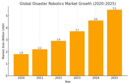
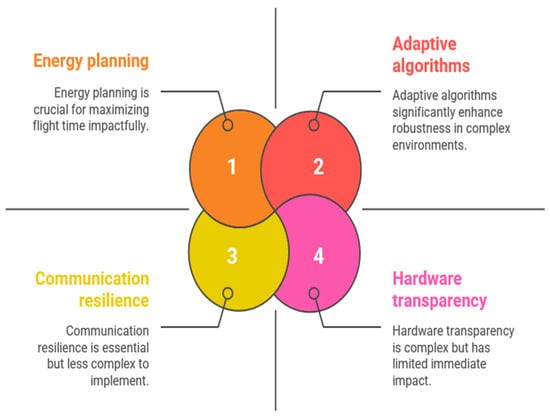
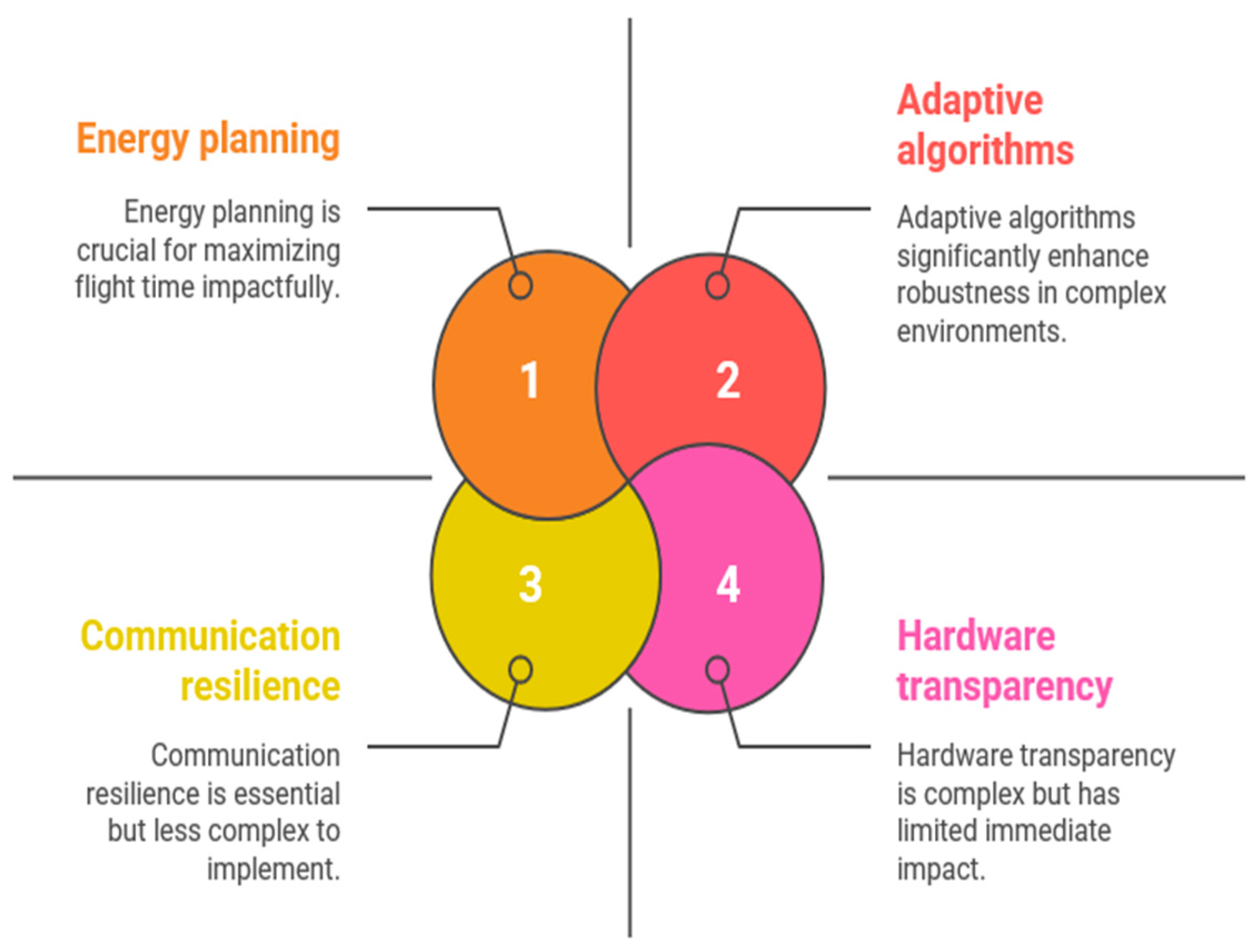
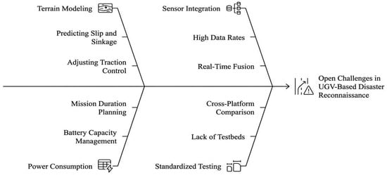
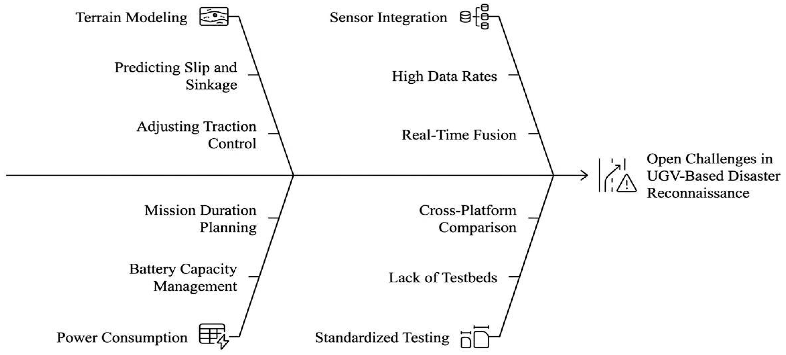
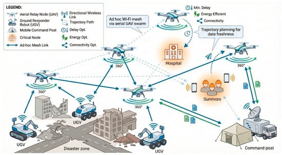
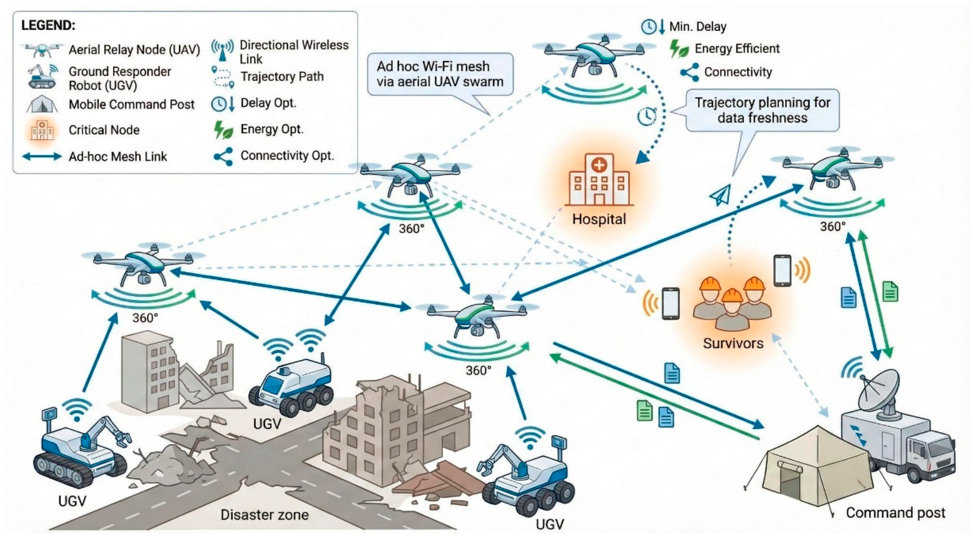
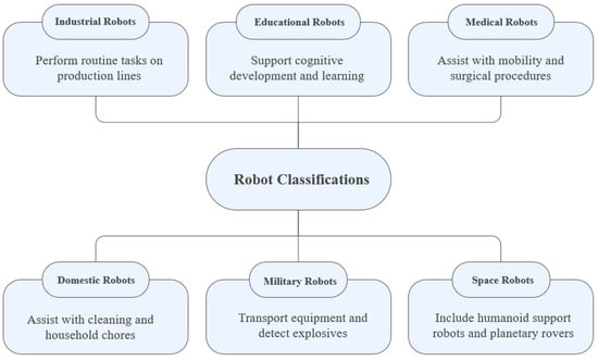
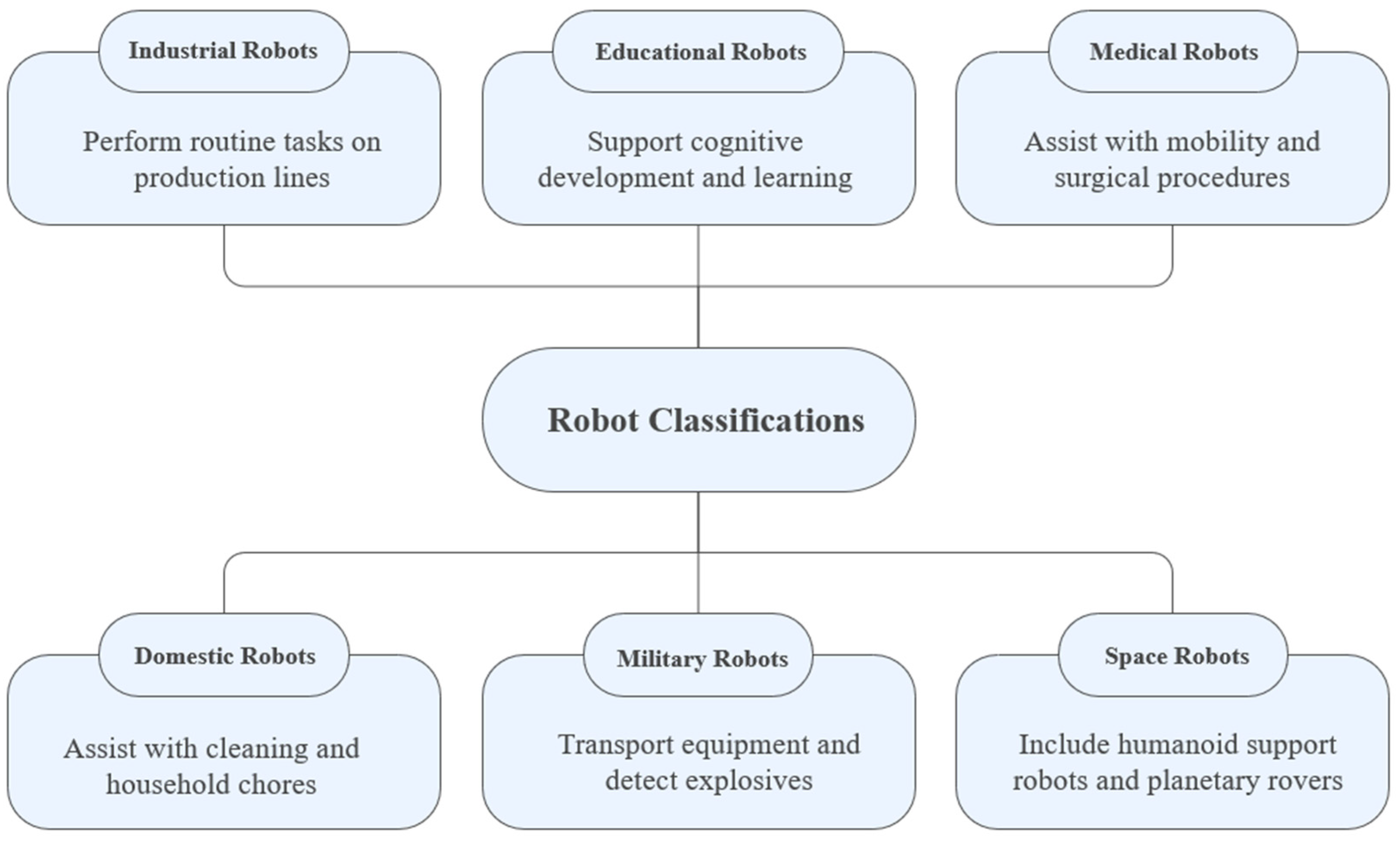
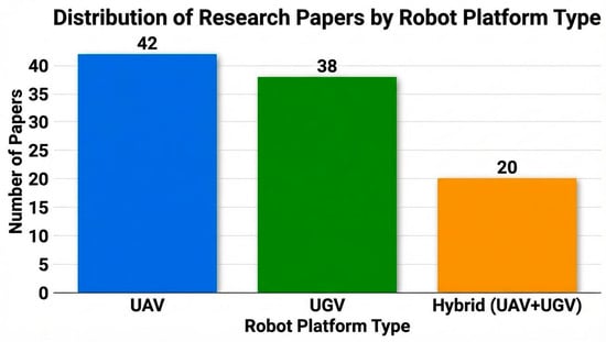
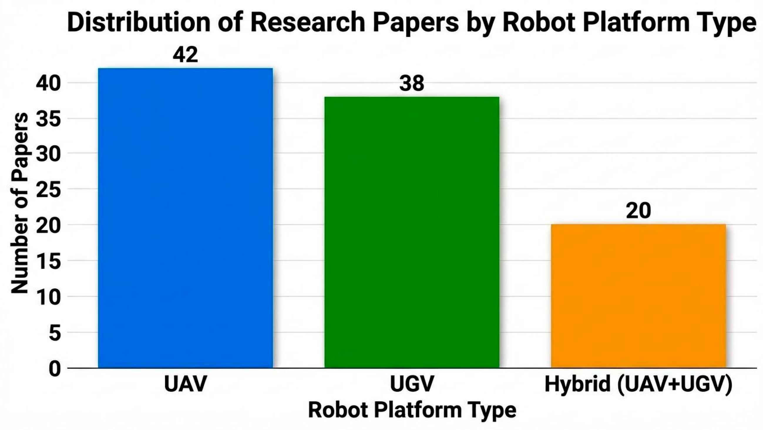
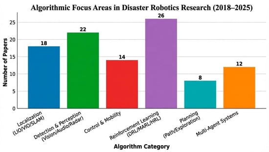
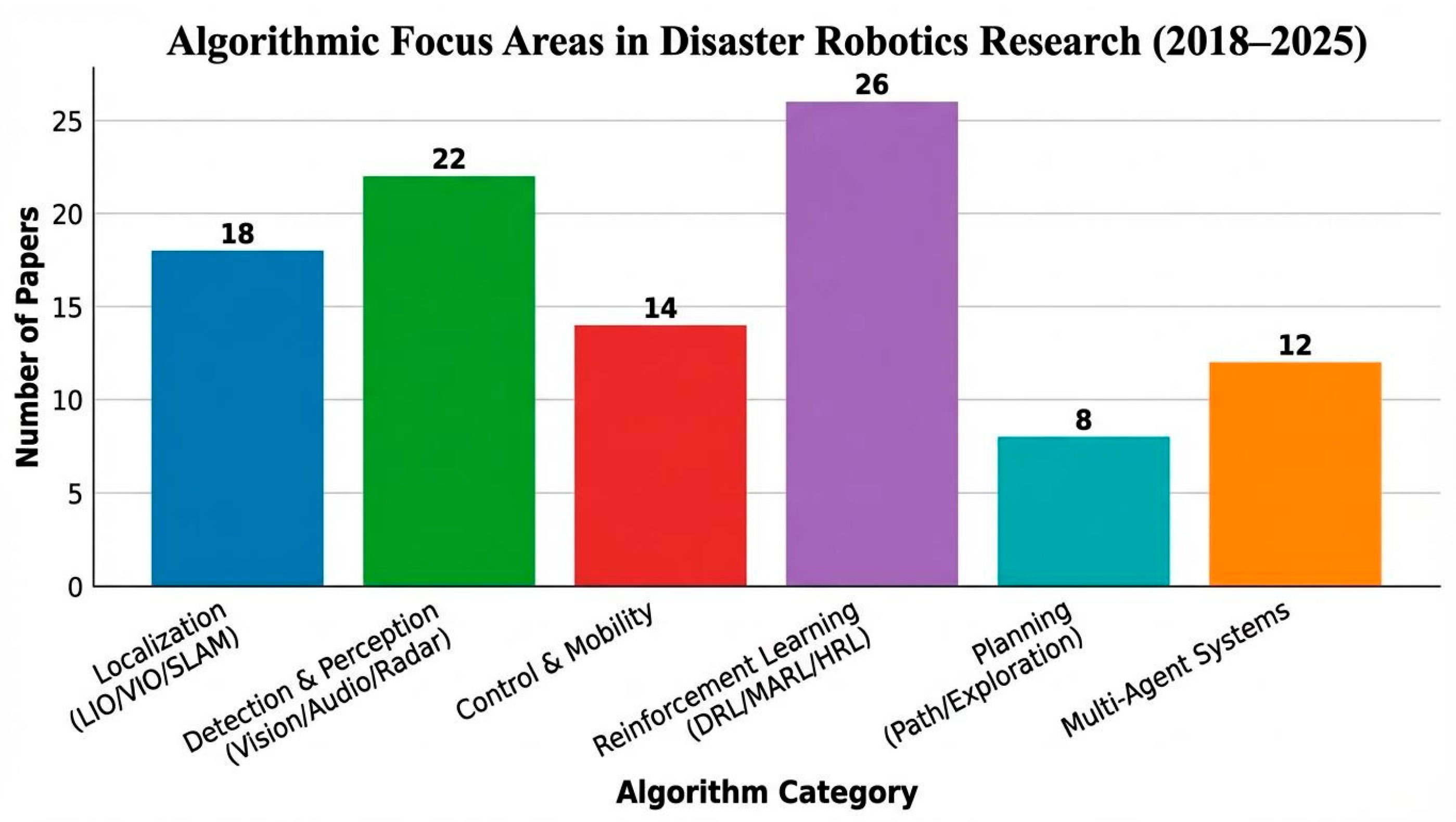
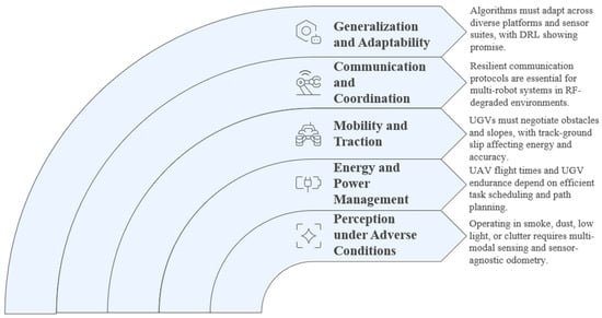
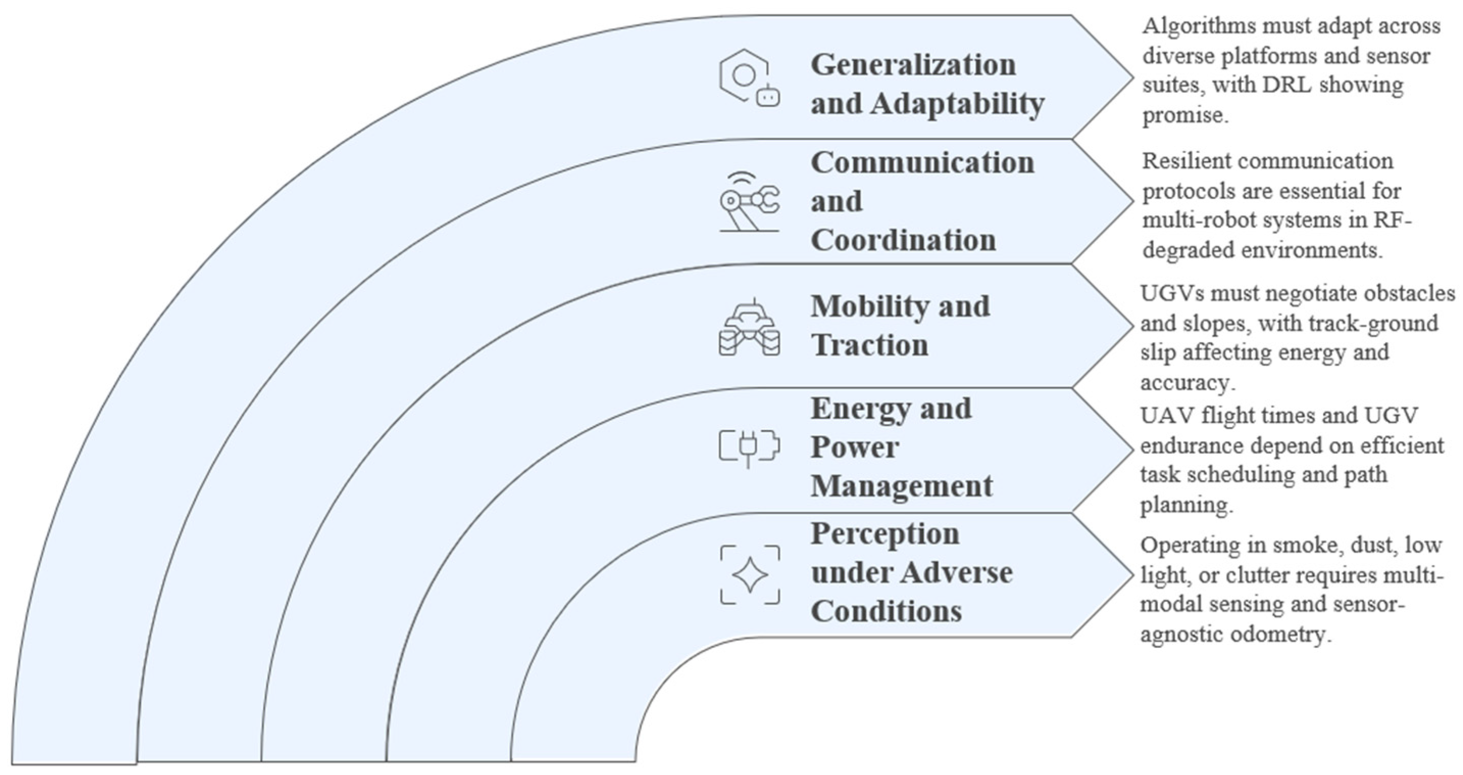
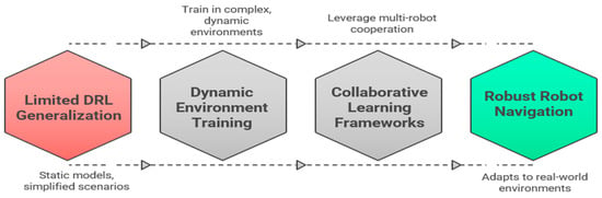
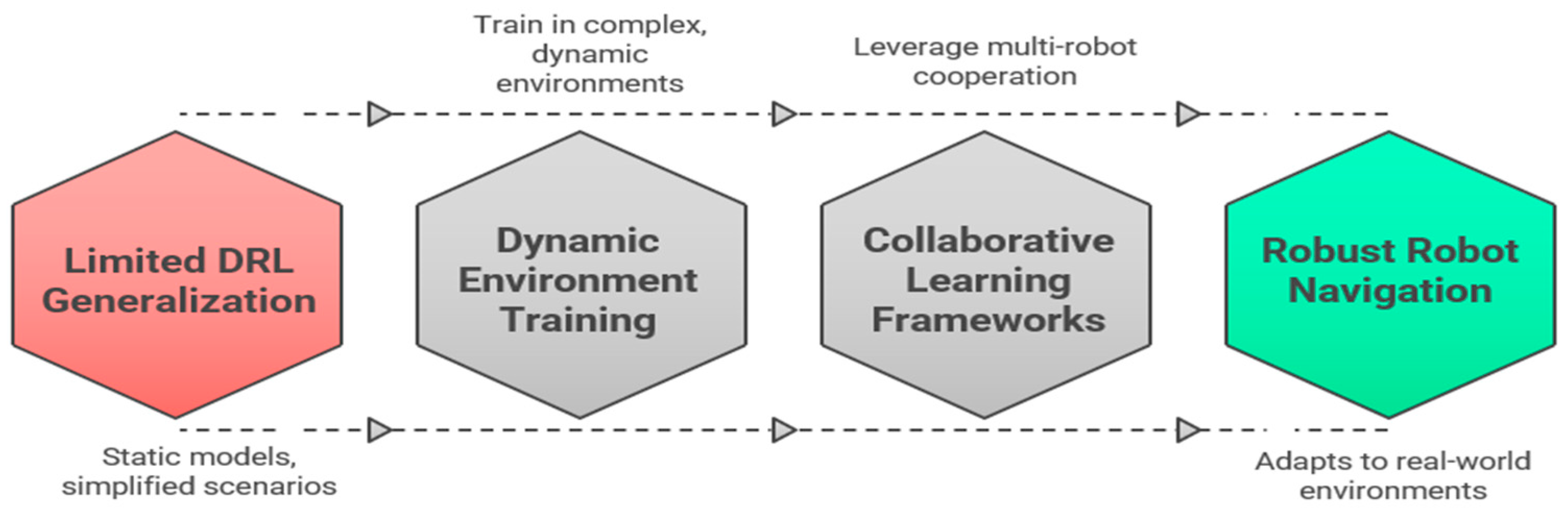
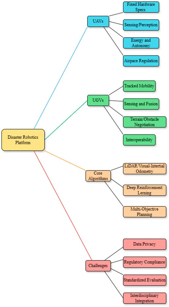
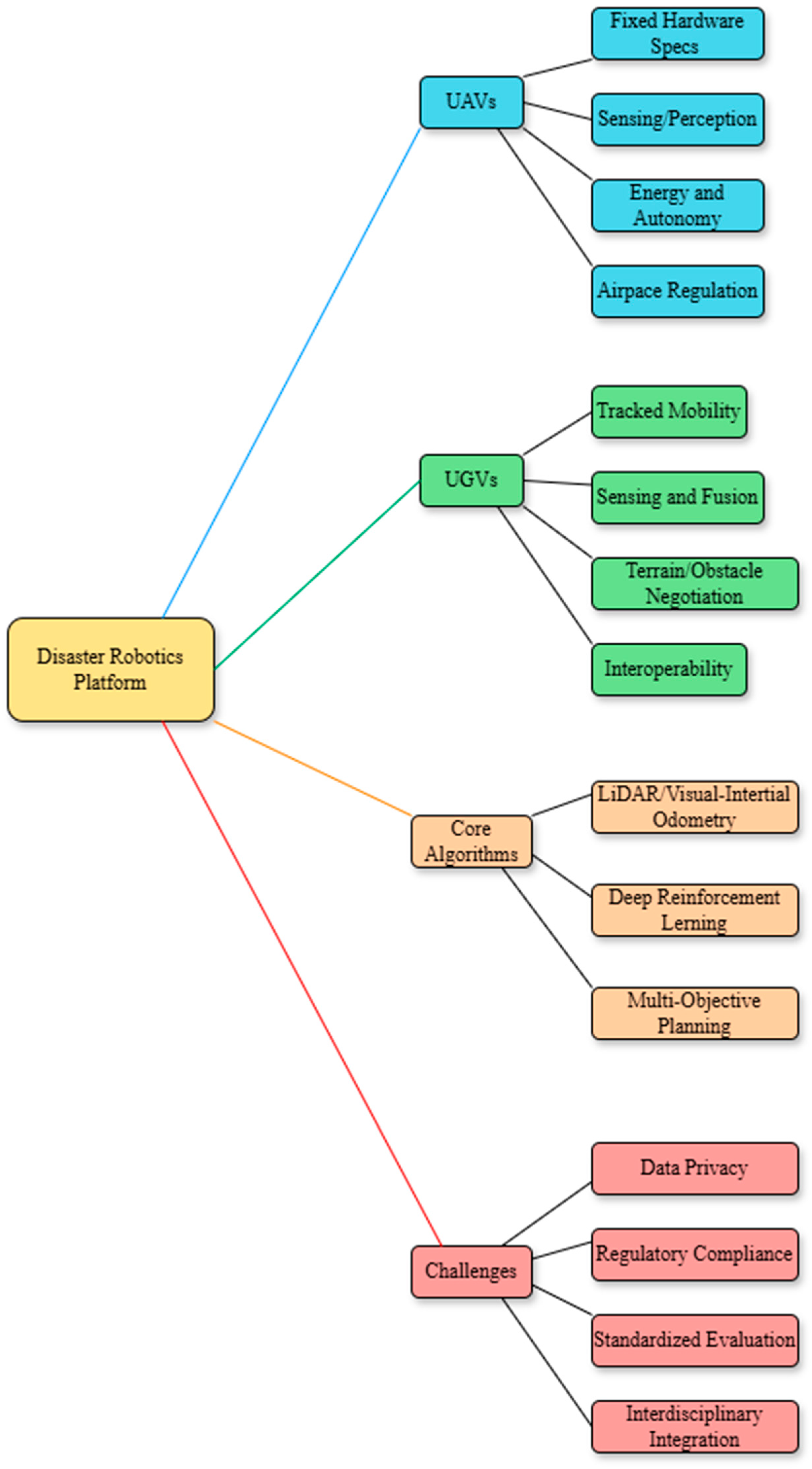

Disclaimer/Publisher’s Note: The statements, opinions and data contained in all publications are solely those of the individual author(s) and contributor(s) and not of MDPI and/or the editor(s). MDPI and/or the editor(s) disclaim responsibility for any injury to people or property resulting from any ideas, methods, instructions or products referred to in the content. |
© 2026 by the authors. Licensee MDPI, Basel, Switzerland. This article is an open access article distributed under the terms and conditions of the Creative Commons Attribution (CC BY) license.