Article

Knidos F, L and N: Three Deep Sea Shipwrecks from the Byzantine Period

1
Faculty of Letters, Istanbul University, Istanbul 34134, Türkiye
2
History Department, Luther College, Decorah, IA 52101, USA
*
Author to whom correspondence should be addressed.
Heritage 2026, 9(6), 216; https://doi.org/10.3390/heritage9060216
Submission received: 28 January 2026 / Revised: 7 May 2026 / Accepted: 12 May 2026 / Published: 25 May 2026

Abstract

This study examines three Byzantine-period amphora carriers (Knidos F, L, and N) discovered off the coast of Knidos within the context of Eastern Mediterranean maritime trade. The research is based on deep-water surveys conducted by ROVs from the E/V Nautilus, combined with seabed mapping and typological analysis of amphora assemblages. The Knidos F and L wrecks carried predominantly Günsenin Type I amphorae and date to the 10th–12th centuries, reflecting the revival of Byzantine maritime commerce. Knidos N represents a later, likely 13th-century context with a distinct amphora assemblage. Together, these wrecks highlight the continued commercial significance of the Carian maritime corridor in Byzantine shipping networks.

1. Introduction

Between 2010 and 2012, Dr. Robert Ballard of the Ocean Exploration Trust (OET), in collaboration with a Turkish and American team of oceanographers and archaeologists, carried out multiple ocean exploration expeditions off the southwest coast of Turkey. The study region encompassed the seas adjacent to the Datça peninsula, with a focus on the zone near the ancient and medieval port-city of Knidos at the peninsula’s western tip (Cape Krio, Deveboynu), plus areas off Marmaris (Figure 1). The expedition’s objectives included surveying the seafloor in this geologically complex area, documenting the destructive impacts of trawling on the seabed, and examining any discovered natural or cultural features. Operating aboard OET’s exploration vessel (E/V) Nautilus, the team performed sidescan sonar survey to identify potential sites, followed by inspections using a tandem remotely operated vehicle system named Hercules and Argus. As the primary instrument, Hercules features a multibeam sonar for measuring microbathymetry and an array of HD cameras. Its primary, forward-looking HD camera includes a set of laser scales spaced 10 cm apart to facilitate artifact measurements; the measurements themselves were taken when each artifact was visually squared to the camera; the margin of error is estimated at ~1–2 cm. Argus, designed to hover over Hercules, provided essential lighting and video surveillance. The two vehicles are controlled from a command center on the vessel. The expedition followed a non-intrusive documentation strategy consistent with the principles of the UNESCO Convention for the Protection of the Underwater Cultural Heritage [1], relying on in situ preservation through the avoidance of any physical intervention at the sites. Even with the inherent constraints of a nonintrusive, non-sampling mode of survey, the clear waters of the southeast Aegean enable detailed mapping, imaging, and analysis, permitting thorough documentation of both natural and cultural sites and features. During operations in this region, the team identified 26 shipwrecks off Knidos and another 4 off Marmaris in depths from 100 to 500 m. They date to between the 6th century B.C. and the 19th century of our era [2,3,4,5,6,7,8,9,10,11,12,13].
An unanticipated aspect of documenting these ancient and premodern shipwreck sites with the deep-water ROVs was the assessment of damage to the sites by bottom trawl fishing activities in the coastal deep waters of Turkey [7,13]. Trawl nets are weighted nets held open by wooden doors that drag along the seabed and non-preferentially collect the fish and shellfish that end up in the nets. The weights and doors of the nets carve large furrows in the sediment and any objects present on the seabed. Quantification of trawl damage to the ancient wrecks off Turkey established that most were damaged to some extent by trawling, and some were heavily damaged with more than 60% of the ceramic artifacts on site exhibiting breaks [3,4,6,7]. The heaviest damage was seen on wrecks located farther from shore and along flat contours, such as along the coast south of the Datça peninsula where trawling vessels can operate easily along isobaths easily. Wrecks that escaped heavy damage were typically those located in steeper areas of bathymetry, such as between Knidos and Kos, or those closer to shore where a no-trawl zone exists for the Turkish coastline within 2.5 km of the coast.
Among the thirty deep-water sites surveyed, Knidos F, Knidos L, and Knidos N have been identified as Byzantine-period shipwrecks, located off the coast of the ancient and medieval city of Knidos (Figure 1). Their relative dating is based on the typology of Byzantine transport amphorae, which are typically characterized by piriform or spherical bodies and rounded bottoms, though flat-based variants of similar forms also exist. With the exception of the assemblage at Knidos N, the amphora types represented at these sites are well documented in various Byzantine contexts and established chronological frameworks [14,15,16,17,18,19,20]. The amphora assemblages suggest a date range of the 10th to 12th centuries for Knidos F and L, and the 13th century for Knidos N. Apart from the amphorae observed at all three sites, no other diagnostic artifacts—such as fine wares, potential crew belongings, hull remains, or anchors—are visible on the seabed.

2. Knidos F

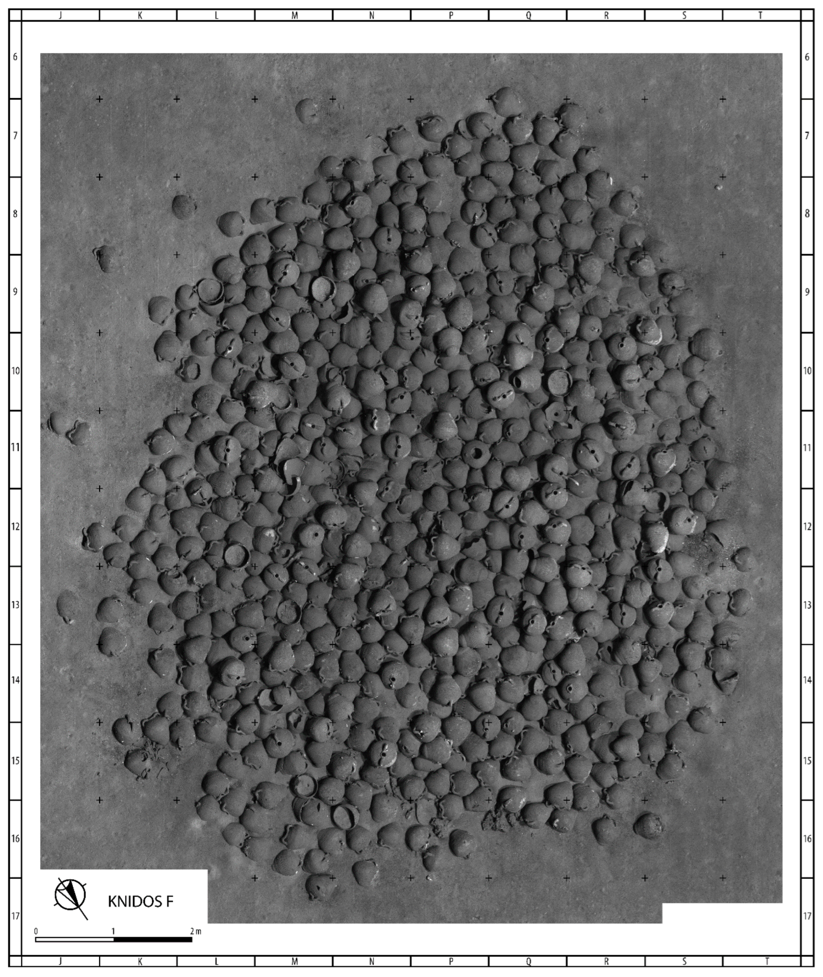
Knidos F is located between the Datça Peninsula and Kos island, approximately 10 nautical miles northeast of Knidos. The shipwreck lies at a depth of 370 m on a flat, sandy sea bed. The debris field, made up of 545 intact or nearly intact visible amphorae and at least 80 fragmented amphorae, covers an area about 12 × 10 m and has a maximum relief of 0.52 m (Figure 2).
A large number of intact amphorae suggests that the wreck has not suffered much from modern damage as no trawl scars are visible on or around the site, likely due to its location near steep topography in the Gulf of Gökova. The sediment partially covering the wreck suggests that a substantial portion of the cargo remains well preserved beneath the visible remains. Moreover, the amphora assemblage forms a compact and coherent deposit, particularly evident at both corners of the site, indicating that the cargo was neither scattered nor displaced. This suggests that the vessel did not capsize but instead came to rest upright on its bottom or keel, thereby raising a strong possibility that the lower hull is preserved in a good state.
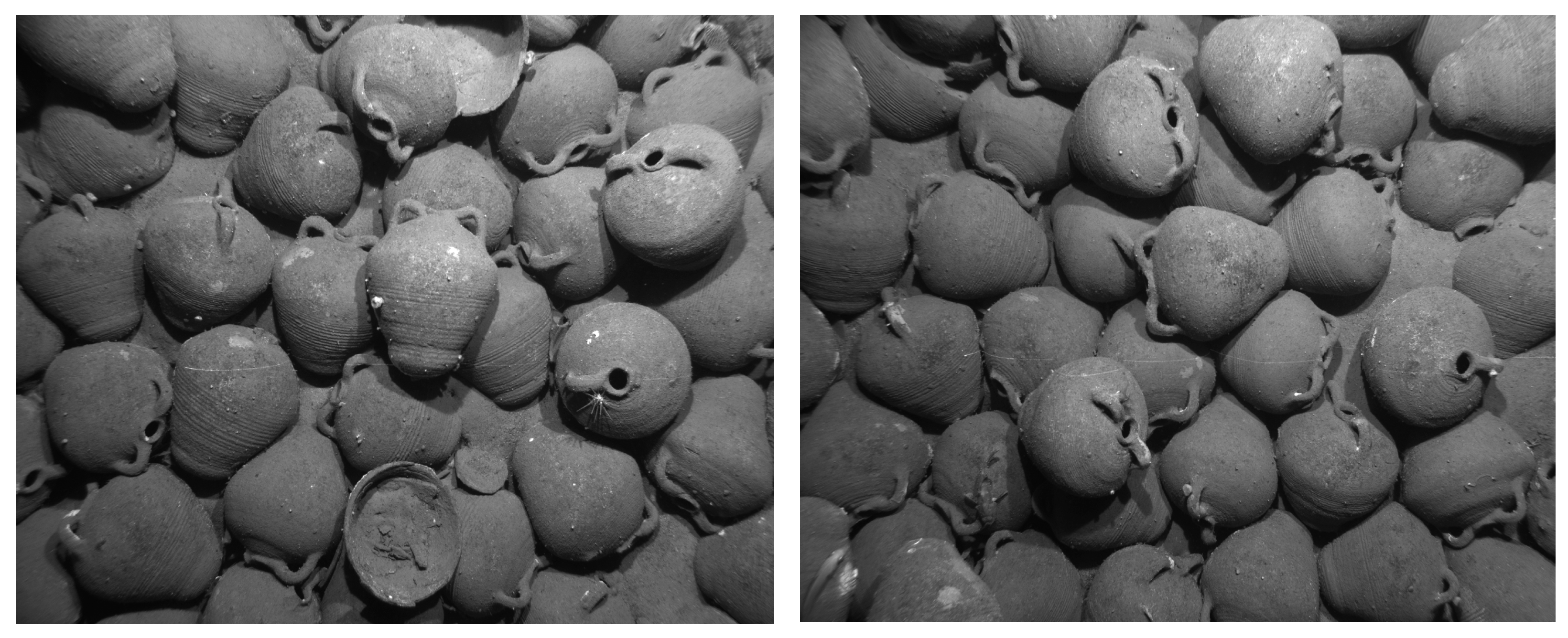
The ship carried a single type of amphora, which is characterized by a very short neck, round belly with a wide shoulder, and a rounded base (Figure 3). Short, arched handles protrude from the rim or from just beneath the rim. The body is completely covered with ribs, which are more widely spaced and thus recognizable below the shoulder. Dimensions of only some amphorae are determined with the help of 0.10 m laser line scales. Available measurements indicate that the amphorae vary between 0.40 and 0.45 m in height and 0.30–0.35 m in diameter. However smaller amphorae are evident on high-resolution images of the site. The amphora assemblage constitutes a representative example of Günsenin Type I, which is widely recognized as having been extensively circulated between the 10th and 12th centuries [16,21].

3. Knidos L

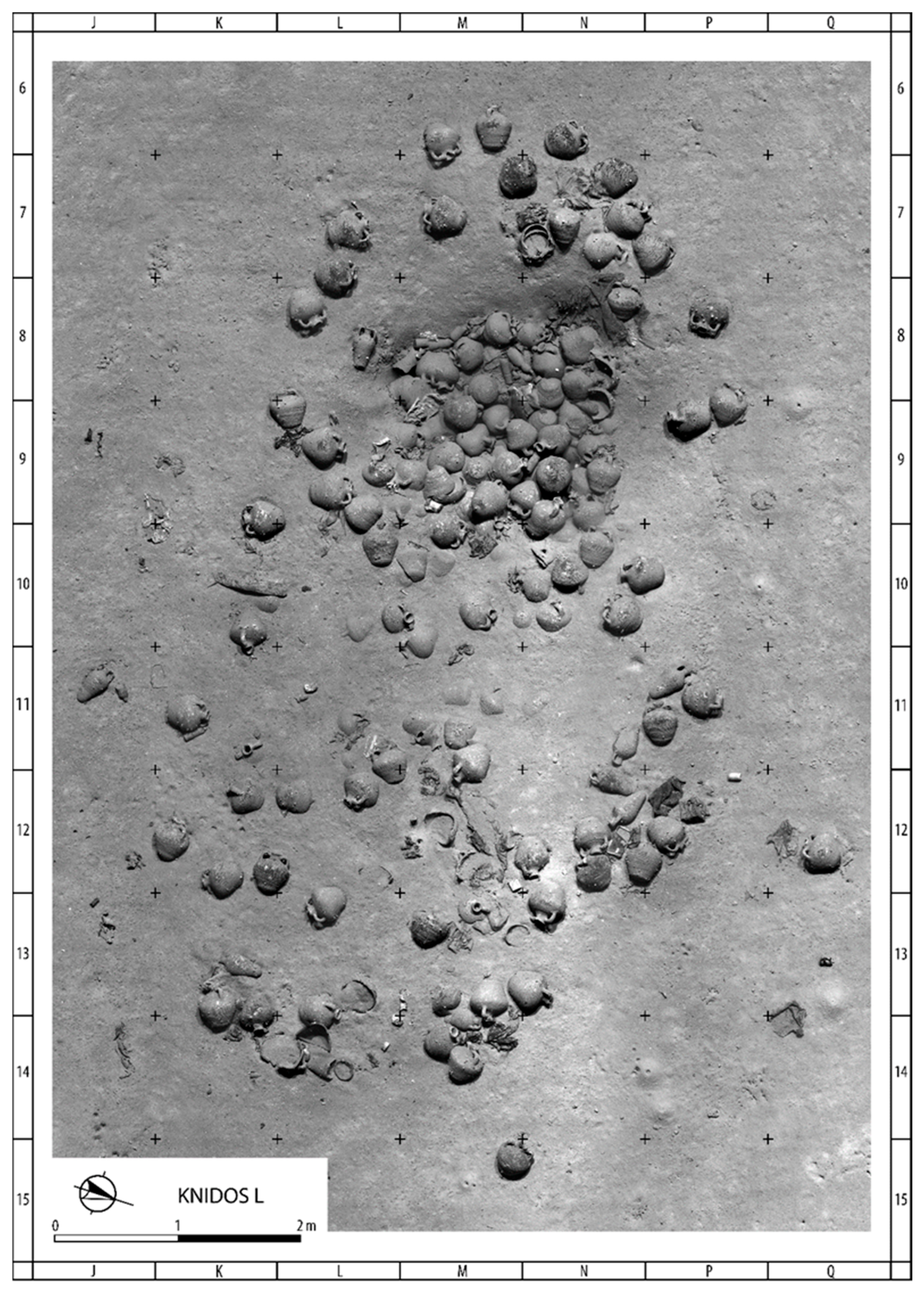
Knidos L was found southeast of Knidos, approximately 3 nautical miles south of Datça Peninsula, at a depth of 418 m. The site is defined by an amphora pile covering an area of 7 × 10 m, oriented on an east–west axis on a sandy sea bed. It does not appear that this wreck has been affected by trawling. At least 116 intact amphorae are evident. Toward the western part of the site where the amphorae are concentrated, an area measuring around 2.5 × 2.5 m is nearly one meter deeper than the surrounding flat sea bed (Figure 4).
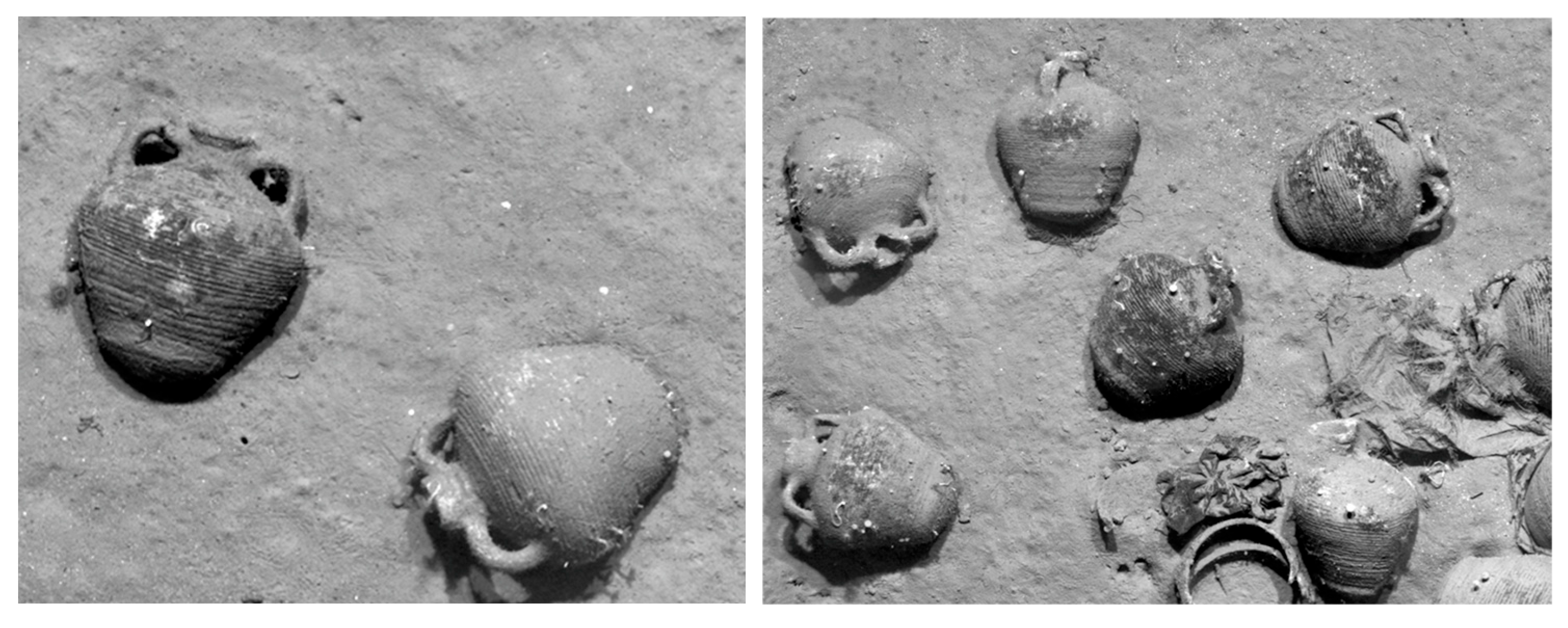
The ship carried at least two types of amphorae on her final voyage. The primary amphora type, numbering 108 out of 116, is quite similar in shape to the Knidos F amphorae with its round belly, wide shoulder, and rounded base (Figure 5). However, Knidos L amphorae have still short but more recognizable necks and short, arched handles, this time protruding from the neck instead of from just beneath the rim. Although it differs in certain features, this type is included in Günsenin’s Type I class of amphorae, a category that unites multiple variations characterized by a shared overall form yet marked by considerable diversity. The available measurements on site indicate the height of this type is between ca. 0.35 and 0.40 m, and the maximum diameter is ca. 0.25 m.
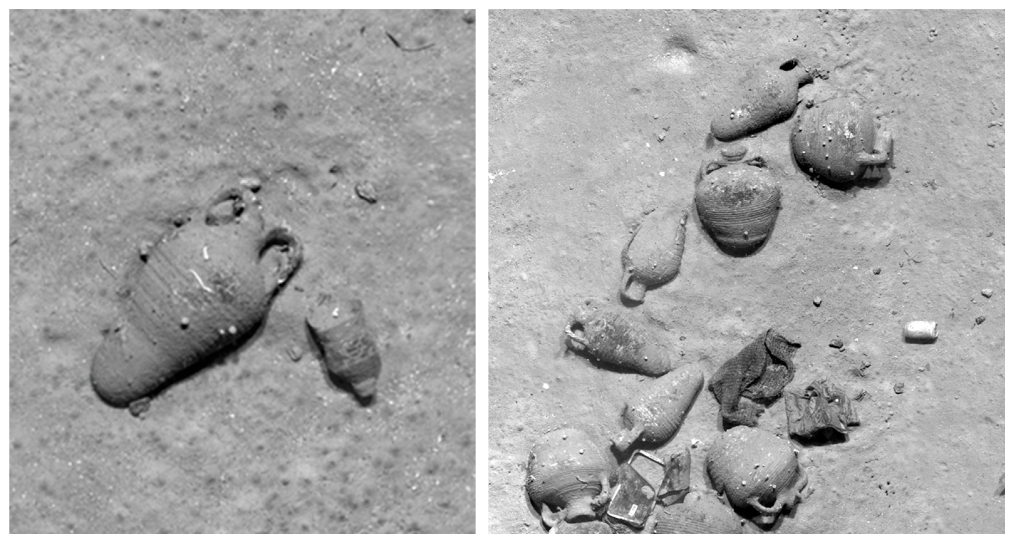
A secondary amphora type is made up of 8 examples. It has a longer neck with a narrow body and rounded narrow base. Straight handles protruding from the rim end on the shoulders. It averages ca. 0.35 m in height and ca. 0.20 m in maximum diameter (Figure 6). Unlike the primary Type I, this group is represented by limited evidence in the Mediterranean. A comparable form, classified by Günsenin as Type XIII, is only known from the 11th-century Serçe Limanı shipwreck and from Antioch in southern Turkey [21,22].

4. Knidos N

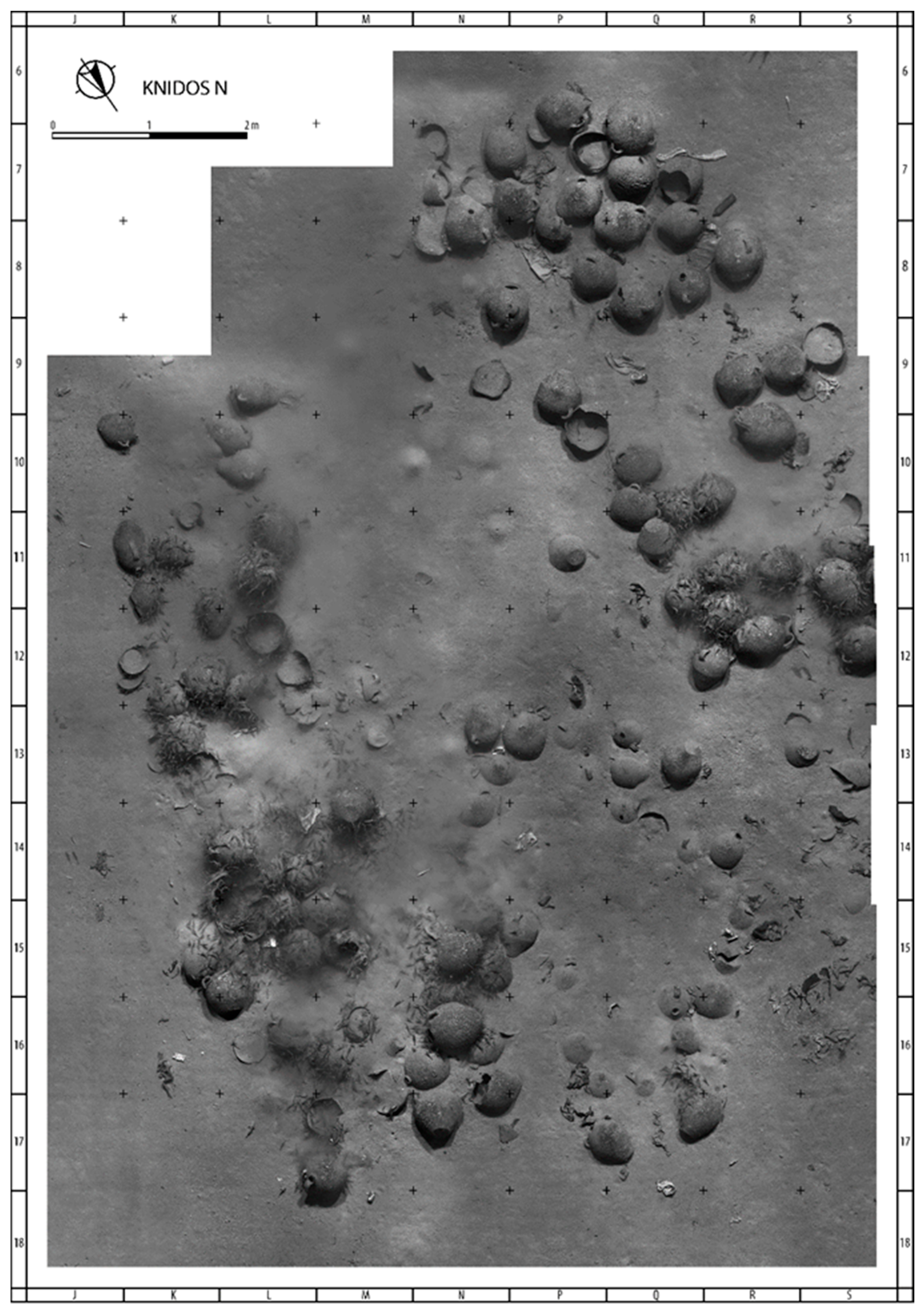
The Knidos N shipwreck lies at a depth of 400 m on a flat sandy seabed, about 3.5 nautical miles southeast of Knidos off the southern coast of the Datça Peninsula. The wreck site, measuring approximately 13 × 9 m, contains 95 intact amphorae concentrated in the western and eastern sections, with fewer finds scattered in between (Figure 7). This distribution may suggest either trawling-related damage or the former presence of a perishable cargo in that area. Trawl scars may be erased over time by currents and sedimentation, whereas broken or disturbed artifacts remain [3]; therefore, this pattern may reflect earlier trawling activity. However, it is also possible that the central section of the vessel, likely corresponding to the main cargo hold, lies at a lower level and is buried beneath sediment, which could account for the lower density of visible amphorae in this area.
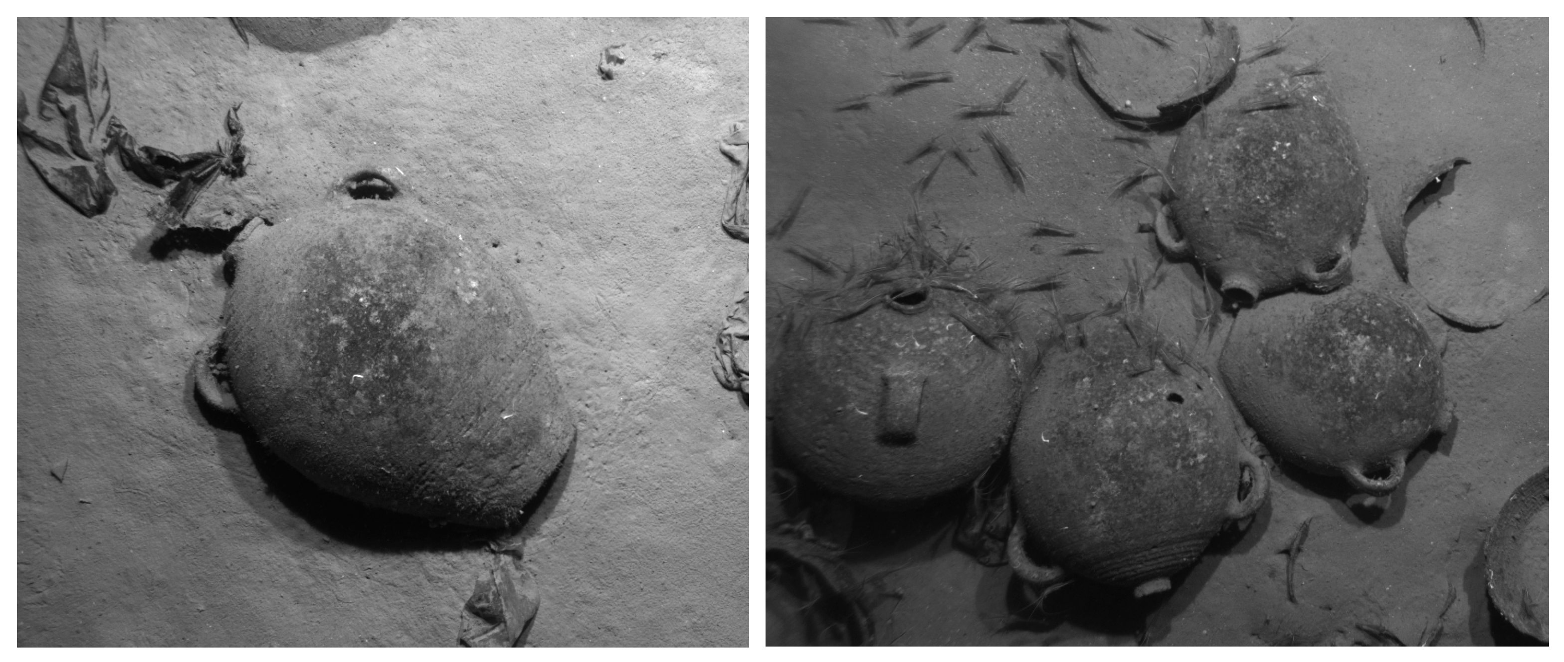
At least two types of amphorae were on board during the time of sinking. The primary type, comprising approximately 77 of the 95 amphorae, features a spherical body tapering to a flat base, a remarkably short and narrow neck, and two handles that are low in height but broader in profile, attached to the shoulders. The maximum diameter of this type is about 0.45 m, its height ranges between 0.50 and 0.53 m, and the flat base measures approximately 0.165 m in diameter. Its upper half exhibits morphological affinities with LRA 5/6 amphorae [23], particularly a small mouth set on a squat neck, and small, semi-circular or ring handles placed on the shoulder. But LRA 5/6’s bag-shaped bottom and rounded base contrasts sharply with the tapering bottom and flat base of this unknown type. In our view, its features argue against its assignation as a variant of any well-recognized type. Indeed, despite an extensive review of the literature, no parallels of this amphora type have yet been identified in the archaeological record (Figure 8).
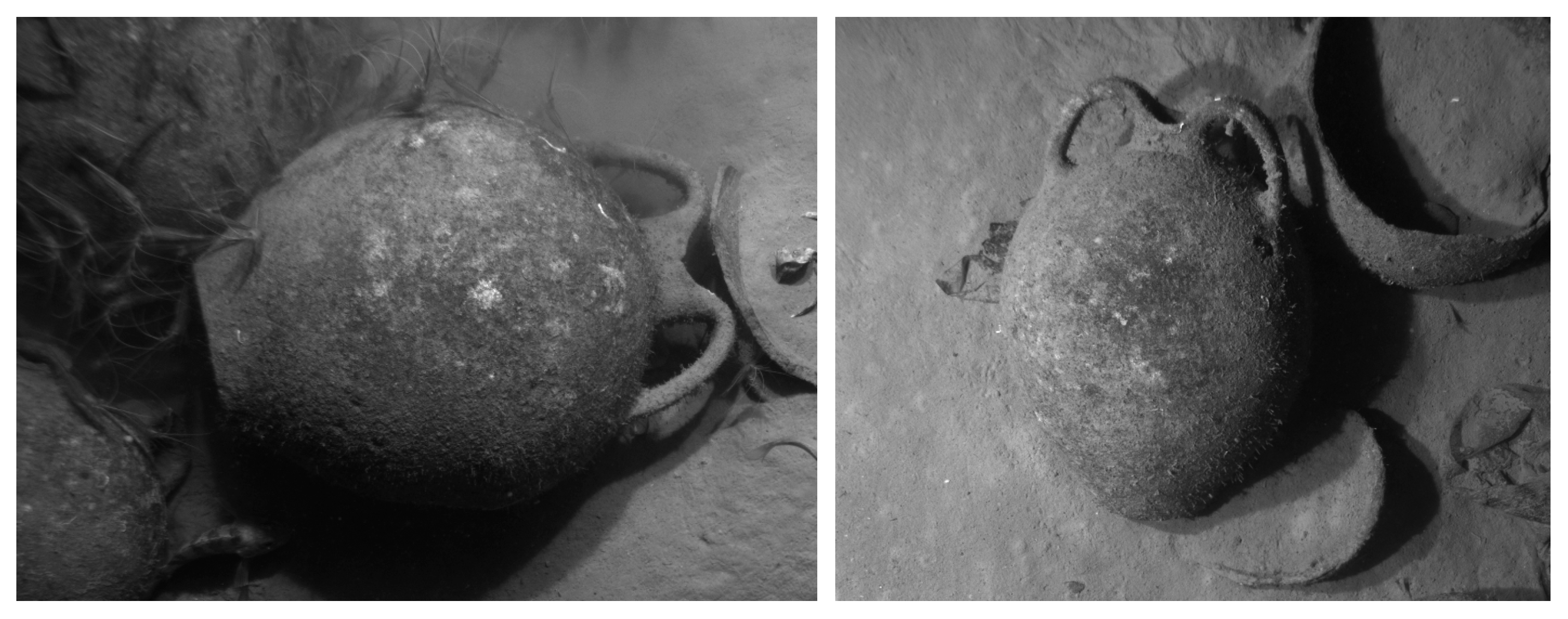
The second type is represented by 9 visible amphorae (Figure 9). It has a round belly with a flat bottom, short neck, and two straight handles which protrude from the rim, rising distinctly above the neck, and end on the shoulders. The diameter of the secondary type is 0.42–0.44 m, while the average height is 0.55 m. It appears to correspond to Günsenin’s Type XXI, reported from the Samsun Museum [16,21] and Crimea in the Black Sea. According to Iakobson, this form belongs to a group primarily used as domestic containers for the storage of grain and small fish, as documented in settlement contexts on the northern Black Sea coast [15]. Similar examples reported from Chersonesos are classified within Romanchuk’s Class 46 [18]. A small number of flat-based jars with similar forms and handle configurations protruding above the rim, recovered from the 13th-century Çamaltı Burnu I shipwreck, offer a further close analogy [24,25]. However, without closer examination, it is not possible to establish a reliable association between this type and those examples, due to potential variations in fabric and dimensions. The wreck is therefore tentatively dated to the 13th century.

5. Günsenin Type I Amphorae

Among the amphora assemblages identified on the three Knidos shipwrecks, a specific type—commonly referred to as Günsenin Type I and forming the primary cargo of the Knidos F and L wrecks—deserves particular attention due to its remarkably wide distribution in the Mediterranean and the growing number of finds documented at both underwater and terrestrial sites in recent decades. In addition to Günsenin’s widely used 1990 [16] classification of Byzantine amphorae, this type has also been identified and classified by other scholars. One of the earliest identifications was made by Demangel and Mamboury in 1939 during the excavations in the Mangana quarter of Constantinople [14], whereas Hayes later referred to it as Type 54 in the Saraçhane excavations of the Church of St. Polyeuktos in Istanbul [17]. The abundance of Günsenin Type I along the western and northern coasts of the Black Sea has attracted scholarly attention, with classifications proposed by Iakobson [15], Romanchuk (Type 42) [18], Sazanov (Type 45) [19], and Todorova (Type 8) [20].
In fact, Günsenin Type I represents a widely distributed amphora type that has been documented across numerous archaeological contexts [21]. Parker’s catalogue of shipwrecks in the Mediterranean lists at least 6 wrecks carrying Type I amphorae, mostly discovered by INA surveys off the Turkish coast in the 1980s [26]. In Günsenin’s survey between 1993 and 1996, 8 of the 13 wrecks around Marmara Island were identified as carriers of Type I. Among these, Tekmezar I is the largest, estimated to have carried approximately 20,000 Type I amphorae [27]. Another major source of Type I finds in the Marmara region includes the excavations at the Theodosian Harbor in Istanbul’s Yenikapı district, where 43% of the massive amphora inventory consists of Type I [28]. In addition to the Type I findings in the harbor silt, final cargo of two of the shipwrecks, Yenikapı 1 and Yenikapı 12, were Type I amphorae [29,30]. Additional examples include the ancient city of Parion [31], Ayvalık Küçük Maden, and Ayvalık Yellice island shipwrecks in the northern Aegean [32]. Toward the south in the vicinity of Knidos F and L, Panaztepe [33], Kadı Kalesi/Anaia [34], Bodrum Museum [35], Knidos Harbor [36], Serçe Limanı shipwreck [37], Marmaris Museum [38], Fethiye Kötü Burun shipwreck [39], Kekova [40], Phaselis [41] and Taşucu Museum [42] also yielded Type I amphorae. Type I amphorae have also been recorded in the Athenian Agora, at the Hagia Sophia of Thessaloniki [16,21], and on the Cape Stoba wreck in the Adriatic [43]. According to Günsenin’s distribution map [21], there are approximately one hundred archaeological sites where Type I amphorae have been identified, ranging from Egypt, Cyprus and the Levantine coast in the south to Varna, Kerch, Crimea, and even Sweden in the north, where the reconstruction of a few sherds indicates the northernmost known example of this type [44].
Günsenin Type I typically features a short neck, a pear-shaped body marked with grooves, and a rounded base. There are variations in shape, such as taller necks, handles attached directly to the rim or to the neck just below the rim, and short, arched handles that sometimes remain below rim level or rise slightly above it. Variation is also evident in the fabric. The color of the clay ranges widely from orange and light beige to brick-red and reddish-brown with or without a cream-colored slip. These differences likely result from varying firing temperatures acting on calcareous clay. It has been observed that calcareous clays tend to lighten in color as firing temperatures increase, shifting from red-orange to beige or even cream. For this reason, color alone should not be overly emphasized in identifying these amphorae—particularly considering that they were likely produced using seawater, which can significantly affect the final color of the ceramic [21].
Although Günsenin Type I is also frequently labelled as “Ganos amphorae” in the literature, this designation is potentially misleading, as it implies a single production center. The wide distribution of Type I amphorae, together with observable variations in fabric and form—particularly in handle placement and rim morphology—suggests the existence of multiple production centers. This diversity has consequently raised terminological issues. Van Doorninck has therefore preferred the use of the term “class” rather than “type” for Günsenin I, as the latter implies a single production origin [21,45]. While the production site of at least one variant of the Günsenin I class has been securely identified in the northwestern Marmara region, based on the excavation of amphora kilns at Gaziköy, the site of medieval Ganos, additional workshops have also been documented at two sites on nearby Marmara Island, opposite Ganos [46,47,48]. Nevertheless, the factors underlying variation within the Günsenin I class—whether related to differences in craftsmanship, regional production traditions, or chronological developments—remain unresolved. Addressing these questions will require further petrographic and chemical analyses together with well-dated archaeological contexts from other potential production centers.
The chronological range proposed for Type I amphorae generally spans the 10th to 12th century. Günsenin suggests the 11th century as the main period of circulation, while Hayes dates them more broadly between the 10th and 12th century based on contexts from the Saraçhane excavations [17,49]. The most secure dating, however, comes from the Serçe Limanı Glass Wreck, where 56 amphorae were identified as Type I. The wreck is reliably dated to the early 11th century through the discovery of Byzantine coins of Basil II (976–1025) and four glass weights [37]. Although the general scholarly consensus places the use of Type I within the 10th–12th century, recent research on the Yenikapı 12 shipwreck suggests an earlier date. Günsenin I amphorae recovered from this vessel have been dated to the 9th century with the help of other findings, such as a 9th century coin and radiocarbon analysis of the hull remains [50]. Due to notable differences in fabric, these amphorae are considered not to have originated in Ganos. Similar examples from Bulgaria also support a 9th–10th century date [51]. According to Vroom [52], the amphorae from Yenikapı 12 appear to represent 9th-century prototypes of Günsenin Type I, characterized by a slightly different body shape, a more pronounced rim, and a reddish self-slip.
Günsenin I, particularly the examples associated with the Ganos region, is commonly linked to the wine trade, especially the renowned sweet wine of the area. Ganos was an important significant monastic center in Thrace, benefiting from favorable climatic conditions for viticulture, abundant high-quality clay sources, and a coastal location that facilitated transport. It is believed that the monastery played a key role in managing both the production and distribution of wine, possibly in conjunction with local shipbuilding. However, written sources concerning the monastery and its organizational structure remain limited [49].

6. Discussion

Cargo amphorae identified on the Knidos F and L shipwrecks suggest that both vessels were merchantmen active in Mediterranean trade between the 10th and 12th centuries. This period marked a resurgence of Byzantine maritime activity following a prolonged phase of Arab dominance that began in the mid-7th century, particularly in the eastern Mediterranean, including Crete, Rhodes, Cyprus, the Levantine coast, and Egypt. The Byzantine recapture of Crete in 961 and Cyprus in 965 restored control over key sea routes, re-establishing security along major maritime corridors [53]. This facilitated the reintegration of coastal port cities and the revitalization of trade between the eastern provinces and the capital, Constantinople. By the 10th and early 11th centuries, the Byzantine Empire stood as the dominant political and economic power in the Mediterranean and the foremost center of Christian civilization. Its territories spanned southern Italy, the Balkans, Greece, and Asia Minor. The economy was stable, anchored by the Byzantine gold coin (solidus) as the standard currency in Mediterranean trade, and supported by a centralized administrative system based in Constantinople. This strong political and economic foundation enabled Byzantium to maintain control over critical maritime trade routes, regulate commercial activity in its ports, and engage in far-reaching exchange networks [54]. Within this framework, both Knidos F and L can be regarded as operating within the empire’s renewed maritime network. The expansive maritime trade network of this period was highly complex, involving numerous actors across a broad geographic area. Tax-exempted monasteries with their own ships, rich merchants in the senate, and landowners and middlemen formed the trade elites. Jacoby [55] explains this complexity through three distinct patterns of maritime transportation. The first involved direct navigation to predetermined ports based on market demand. This practice included both short-distance sailings, often by ship owners who also acted as merchants, and long-distance voyages based on oral or written carriage contracts. Regardless of size, ships frequently sailed fully loaded with commodities like wine, grain, fish, or timber from production or collection centers directly to designated markets. The second pattern, cabotage, consisted of the systematic movement of ships between nearby or moderately distant ports along established routes. The third, tramping, referred to non-scheduled navigation, with vessels making opportunistic stops at various ports without a fixed itinerary. The last two patterns facilitated the decentralized movement and redistribution of goods, as well as limited passenger transport. Tramping, in particular, was primarily undertaken by small-scale traders operating outside large-scale commercial networks. The homogeneity of the cargo amphorae on Knidos F and L—particularly on Knidos F—may suggest that these vessels were engaged in a structured pattern of transportation rather than tramping. Nevertheless, the available evidence limits any definitive interpretation regarding the ship’s route or the precise nature of its cargo. The possible routes of both ships are numerous. The Black Sea and the Mediterranean functioned as distinct commercial zones, each with its own trade patterns and shipping networks. Constantinople acted as both a terminal and transshipment hub between these regions. During the 11th and 12th century, direct voyages between the two seas appear to have been rare. Although archaeological findings in the Adriatic offer important insights, evidence for Byzantine maritime trade with the west in the 11th century is nonetheless scarce as well. On the other hand, written sources indicate that maritime traffic between Constantinople, the Aegean, the coasts of southern Anatolia, the Levant, and Fatimid Egypt was remarkably active during this period. The Book of Curiosities [56], an 11th-century illustrated manuscript compiled in Egypt, lists 26 major harbor towns and anchorages along the southern coast of Anatolia, from Strobilos (near modern Bodrum) to the Pyramus River (modern Ceyhan), followed by forty additional locations extending south to Egypt. It also marks over a hundred islands across the eastern Mediterranean, including some in the northern Aegean. This detailed geographic record of Byzantine coasts by a Fatimid author reflects the strong maritime connectivity of the period. By the early 11th century, a decline in naval hostilities, a series of peace treaties, evidence of reciprocal Byzantine–Fatimid trade, increased pilgrimage traffic, the abundance of contemporary geographic knowledge, and archaeological finds such as the Serçe Limanı shipwreck all attest to an expansion of commerce and the integration of northern and southern maritime routes in the eastern Mediterranean. The positions of the Knidos F and L shipwrecks along the Carian maritime corridor may indicate a potential association with major nearby trade centers such as Strobilos and Rhodes, both of which were part of the Byzantine theme of the Kibyrrhaiots. This maritime theme functioned as the principal naval district of the Byzantine Empire, encompassing much of the southern Anatolian coastline under the authority of a strategos, a military governor. As outlined in De thematibus, it extended from Miletos in the west to Seleukeia in the east, incorporating key maritime centers across Caria, Lycia, and Pamphylia [57]. This zone formed a structured maritime landscape that interconnected naval bases, commercial ports, and logistical stations, facilitating movement along the Anatolian coast. Within this framework, strong commercial ties with the Fatimid realm suggest that the routes followed by the Knidos F and L vessels may also have extended to the Levantine coast, as evidenced by the Serçe Limanı shipwreck [58,59]. The presence of Günsenin I amphorae on board both Knidos F and L, similar to those at Serçe Limanı, may even suggest a further northern extension of their voyages into the Sea of Marmara. The wide distribution of Type I amphorae indicates that they served as a dominant transport container in both regional and long-distance trade networks, particularly in the Black Sea, the Aegean, and the Marmara regions. Their presence in both eastern and western Mediterranean contexts points to connections between Byzantine production centers—possibly in northwestern Anatolia or Thrace—and broader Mediterranean trade routes during the 10th to 12th centuries. However, a direct link of Knidos F and L to Ganos wine and its production center remains uncertain due to the widespread practice of amphora reuse. In addition, ongoing debates regarding the origins of certain variants within the Günsenin I class limit definitive conclusions. A broader typological study, combined with comparative petrographic analysis, is therefore essential to clarify the origins, development, and distribution of this amphora type.
While Knidos F and L reflect a period of economic expansion in the Byzantine Empire, Knidos N represents a very different context, one marked by economic contraction and political instability in the eastern Mediterranean. Its sinking appears to coincide with this turbulent phase, and although the dating is not definitive, at least one amphora type aboard resembles 13th-century examples. This suggests that Knidos N may have been part of the shifting maritime patterns characteristic of the late Byzantine Period. By the end of the 11th century, the well-established maritime trade networks of Fatimid and Byzantine shipping, which had long attracted numerous foreign merchants, were increasingly displaced by the Italian city-states of Venice, Genoa, and Pisa until the empire’s fall in the mid-15th century. Privileges granted in exchange for naval assistance, the establishment of foreign maritime bases, particularly after the Latin occupation of Constantinople, and evidence from contemporary European accounts all point to a gradual loss of Byzantine dominance [60,61]. This erosion of control was further compounded by the rise of Turkish maritime activity along the coasts of southern Anatolia and the Aegean, especially after the 13th century [62]. However, as Pryor [63] notes, the narrative of Western domination in Byzantine waters relies heavily on European archival sources concerning their own maritime operations, which may not accurately reflect the full scope of maritime activity, given the limited systematic research on this period in the eastern Mediterranean. Archaeological evidence for 13th-century maritime commerce, particularly the number of well-documented shipwrecks, is also scarce. Notable examples include the Çamaltı Burnu I wreck in the Sea of Marmara, a wreck off Kastellorizo near Kaş in southern Anatolia [64] and one off Tartous in Syria [65]. All three indicate the circulation of Byzantine wares, though the origins of the ships remain uncertain; only the Çamaltı Burnu I wreck provides clear evidence of Greek merchants on board [25]. According to Parker’s catalog [26], seven of the 39 shipwrecks dated between 1200 and 1450 across the Mediterranean have been identified as carrying Byzantine cargo. The origins of the cargo on the remaining 26 wrecks could not be determined. Of the six additional wrecks, two were linked to the Mamluks, three carried Italian cargo, and one transported Turkish material, all based on preliminary assessments rather than comprehensive analysis. The latest evidence of the period, Knidos N, demonstrates the continued use of the Carian maritime corridor linking the Aegean, southern Anatolia, and the Levantine coast during the Late Byzantine period. This route was likely employed by vessels engaged in coastal cabotage along a north–south axis, covering short-to-moderate distances, rather than by ships following the western route that reached the Levant via Peloponnese, Rhodes and Cyprus without adhering to coastal navigation. The absence of close parallels for its primary cargo of amphora may indicate a localized production center with a limited distribution network or a specialized function that has yet to be documented in other contexts. The resemblance of the secondary amphora type to 13th-century examples requires further study to determine possible points of origin.
In addition to the absence of any diagnostic evidence, such as tableware that might help identify the crew or possible origins of Knidos F, L, and N, there are no visible hull remains, rigging, or anchors at any of the three sites to help determine the nature of the ships themselves. Typical Byzantine ships of this period were relatively small-sized vessels rigged with one or two lateen sails, a pair of quarter rudders mounted at the stern, a shallow keel, multiple wales, and often only partial decking at the bow and stern. These vessels featured rounded bows and sterns, along with broad hulls, giving them a full, rounded appearance. This general hull form characterized most Mediterranean sailing ships up to the 14th century [66]. The largest assemblage of Byzantine-period shipwrecks uncovered at the Theodosian Harbor in the Yenikapı district of Istanbul supports this assessment, although exceptions occur in the archaeological record. Considering both the number of amphorae and the area covered by the cargo on all three sites, the Knidos F, L, and N vessels appear to conform to this pattern, with cargo capacities that probably did not exceed 30 tons.

Author Contributions

Conceptualization, E.T.; Methodology, D.D.; Writing—original draft, E.T.; Writing—review & editing, D.D. All authors have read and agreed to the published version of the manuscript.

Funding

Financial support for the expeditions was provided by NOAA’s Office of Ocean Exploration and Research (NA11O AR4600060, NA11O AR4600071, NA08O AR4600534, NA10O AR4600127), the Expedition Council of the National Geographic Society, and the Office of Naval Research (N00014-07-1-0301).

Data Availability Statement

NOAA’s open data policy for oceanographic expeditions mandates rapid, unrestricted public access to scientific data from missions, prioritizing timely sharing to support science, management, and public engagement. Please direct all data inquiries to the corresponding author or OER.info.mgmt@noaa.gov.

Acknowledgments

This work was conducted under Marine Scientific Research permits from the Ministry of Foreign Affairs of the Republic of Turkey numbered 2011/DHGY/7124361 and 2012/DHGY/5852515. We wish to thank the Turkish Ministry of Culture and Tourism for permission to conduct research and imaging, and for co-sponsoring (with Ocean Exploration Trust) the symposium “Archaeological Oceanography in the Mediterranean and Black Sea: A Symposium on the E/V Nautilus and STS Bodrum Expeditions to Turkey 2009–2013,” held at Bodrum on 19–20 October 2014. We wish to thank İlknur Subası and Hüseyin Vural of the Ministry of Culture and Tourism for their co-sponsorship and their attendance at the conference. We also wish to express our gratitude to the Turkish Ministry of Foreign Affairs for granting marine scientific research permits for certain aspects of our expeditions. We thank Güner Özler and Harun Özdas who were on-board commissioners representing the Ministry of Culture and Tourism, and Muhammet Duman and Nilhan Kızıldağ who were on-board commissioners representing the Ministry of Foreign Affairs. We are most grateful to Robert D. Ballard, Michael L. Brennan, Katy Croff Bell, and Tufan Turanlı for their assistance and collaboration, and to Nergis Günsenin for her advice and expertise. The authors would like to thank the Honor Frost Foundation for covering the APC through the Honor Frost Open Access Award. Finally, we extend our sincere gratitude for the thoughtful and helpful advice of the anonymous reviewers. All errors remain the authors’ own.

Conflicts of Interest

The authors declare no conflicts of interest. The funders had no role in the design of the study; in the collection, analyses, or interpretation of data; in the writing of the manuscript; or in the decision to publish the results.

Abbreviations

The following abbreviations are used in this manuscript:
E/VExploration Vessel
HDHigh Definition
OETOcean Exploration Trust
ROVRemotely Operated Vehicle
UNESCOUnited Nations Educational, Scientific and Cultural Organization

References

  1. Unesco.org. Available online: https://www.unesco.org/en/legal-affairs/convention-protection-underwater-cultural-heritage?hub=412 (accessed on 30 August 2025).
  2. Brennan, M.L.; Turanlı, T.; Buxton, B.; Bell, K.L.C.; Roman, C.; Kofahl, M.; Köyağasıoğlu, O.; Whitesell, D.; Chamberlain, T.; Sullivan, R.; et al. Landscape Imaging of the Southeast Aegean Sea. Oceanography 2011, 18–19. [Google Scholar]
  3. Brennan, M.L.; Ballard, R.D.; Roman, C.; Bell, K.L.C.; Buxton, B.; Coleman, D.F.; Inglis, G.; Köyağasıoğlu, O.; Turanlı, T. Evaluation of the modern submarine landscape off south-western Turkey through the documentation of ancient shipwreck sites. Cont. Shelf Res. 2012, 43, 55–70. [Google Scholar] [CrossRef]
  4. Brennan, M.L.; Ballard, R.D.; Duman, M.; Roman, C.; Inglis, G.; Tuzun, S.; Turanlı, T. Continued Documentation of the Coastal Landscape Off the Datça Peninsula, Turkey. Oceanography 2012, 25, 28–29. [Google Scholar]
  5. Brennan, M.L.; Ballard, R.D. Deepwater Ancient Shipwrecks of the Mediterranean, Aegean, and Black Seas: 1988–2012. Oceanography 2013, 26, 22–25. [Google Scholar]
  6. Brennan, M.L.; Davis, D.; Ballard, R.D.; Trembanis, A.C.; Vaughn, J.I.; Krumholz, J.S.; Delgado, J.P.; Roman, C.N.; Smart, C.; Bell, K.L.C.; et al. Quantification of Bottom Trawl Fishing Damage to Ancient Shipwreck Sites. Mar. Geol. 2016, 371, 82–88. [Google Scholar] [CrossRef]
  7. Brennan, M.L. Quantifying impacts of trawling to shipwrecks. In Site Formation Processes of Submerged Shipwrecks; Keith, M.E., Ed.; University Press of Florida: Gainesville, FL, USA, 2016; pp. 157–178. [Google Scholar]
  8. Opaiţ, A.; Davis, D.; Brennan, M.L. Roman Commerce and Elite Markets in the Eastern Mediterranean: A Case Study of Three 2nd-Century Shipwrecks off Knidos. In Koinè et Mobilité Artisanale Entre la Méditerranée et la mer Noire dans l’Antiquité. Hommage à Pierre Dupont à son 70e Anniversaire; Avram, A., Buzoianu, L., Lungu, V., Eds.; Musée d’histoire nationale et d’archéologie: Constanţa, Romania, 2018; pp. 299–334. [Google Scholar]
  9. Brennan, M.L.; Davis, D.; Opaiţ, A.; Stay, M. Deep-Water Shipwrecks as a Microcosm of Late Roman Maritime Exchange in the Eastern Mediterranean. J. Rom. Archaeol. 2020, 33, 291–329. [Google Scholar] [CrossRef]
  10. Davis, D.; Brennan, M.L. The Knidos Q and Marmaris D Shipwrecks: Two small vessels with Rhodian pottery from the Late Ottoman Period. Int. J. Naut. Archaeol. 2020, 49, 194–202. [Google Scholar] [CrossRef]
  11. Opaiţ, A.; Davis, D.; Matheny, R.; Brennan, M.L. A Case Study of Rhodian Wine Export: The Knidos K and J Shipwrecks. Skyllis 2021, 21, 76–90. [Google Scholar]
  12. Davis, D.; Opaiţ, A.; Brennan, M.L. The Knidos W Shipwreck: A Tile Carrier from the 1st Century B.C. Skyllis 2024, 39, 40–57. [Google Scholar]
  13. Brennan, M.L. Quantification of bottom trawl damage to ancient shipwrecks: A case study from the coastal waters of Turkey. In Threats to Our Ocean Heritage: Bottom Trawling; Jarvis, C., Ed.; Springer: London, UK, 2024; pp. 41–52. [Google Scholar]
  14. Demangel, R.; Mamboury, E. Le Quartier des Manganes et la Premiére Région de Constantinople; E. de Boccard: Paris, France, 1939. [Google Scholar]
  15. Iakobson, A.L. Keramika i Keramicheskoe Proizvodstvo Srednevekovoi Tavriki; Nauka: Leningrad, Russia, 1979. [Google Scholar]
  16. Günsenin, N. Les Amphores Byzantines (Xe-Xllle Siécles): Typologie, Production, Circulation D’aprés Les Collections Turques. Ph.D. Thesis, Université Paris I Panthéon Sorbonne, Paris, France, 1990. [Google Scholar]
  17. Hayes, J.W. Excavations at Sarachane in Istanbul, Volume II: The Pottery; Princeton University Press and Dumbarton Oaks Research Library and Collection: Princeton, NJ, USA, 1992. [Google Scholar]
  18. Romanchuk, A.B.; Sazanov, A.V.; Sedikova, L.V. Amfory iz Kompleksov Vizantiĭskogo Khersona; Ural State University: Yekaterinburg, Russia, 1995. [Google Scholar]
  19. Sazanov, A. Les amphores de l’Antiquité tardive et du Moyen Age: Continuité ou rupture? Le cas de la Mer Noire. In La Céramique Médiévale en Méditerranée: Actes du VIe Congrès de L’AIECM2 Aix-en-Provence 13–18 Novembre 1995; d’Archimbaud, G.D., Ed.; Narration Editions: Aix-en-Provence, France, 1997; pp. 87–102. [Google Scholar]
  20. Todorova, E. Byzantine Amphorae from Present-Day Bulgaria (7th–14th Century AD). Ph.D. Thesis, Sofia University, Sofia, Bulgaria, 2012. [Google Scholar]
  21. Günsenin, N. La typologie des amphores Günsenin: Une mise au point nouvelle. Anatolia Antiq. 2018, XXVI, 89–124. [Google Scholar] [CrossRef]
  22. Ochre.lib.ucihago.edu. Available online: https://pi.lib.uchicago.edu/1001/org/ochre/04e64a48-9cb0-4eec-9266-de0c1f9208a4 (accessed on 30 August 2025).
  23. Vroom, J. Trading Activities in the Eastern Mediterranean through Ceramics between Late Antiquity and Fatimid Times (Seventh- Tenth/Eleventh Centuries). In Egypt and the Eastern Mediterranean World-From Constantinople to Baghdad 500–1000 CE; Bruning, J., de Jong, J.H.M., Sijpesteijn, P.M., Eds.; Cambridge University Press: Cambridge, UK, 2022; pp. 272–322. [Google Scholar]
  24. Günsenin, N. L’épave de Çamaltı Burnu I (Île de Marmara, Proconnèse): Résultats des campagnes 1998–2000. Anatolia Antiq. 2001, IX, 117–133. [Google Scholar] [CrossRef]
  25. Günsenin, N. L’épave de Çamaltı Burnu I (île de Marmara, Proconnèse), résultats des campagnes 2001–2002. Anatolia Antiq. 2003, XI, 361–376. [Google Scholar] [CrossRef]
  26. Parker, A.J. Ancient Shipwrecks of the Mediterranean & the Roman Provinces; Tempvs Reparatvm Archaeological and Historical Associates Ltd.: Oxford, UK, 1992. [Google Scholar]
  27. Günsenin, N. 1994 Yılı Marmara Adaları Sualtı Araştırması. In Proceedings of the XIII. Araştırma Sonuçları Toplantısı, Ankara, Türkiye, 29 May–2 June 1995. [Google Scholar]
  28. Öncü, Ö.E.; Çölmekçi, S. Yenikapı Kazıları ve Bizans Dönemi Amphora Buluntuları. In Proceedings of the XIth Congress AIECM3 on Medieval and Modern Period Mediterranean Ceramics Proceedings, Antalya, Turkey, 19–24 October 2015. [Google Scholar]
  29. Pulak, C.; Ingram, R.; Jones, M. Eight Byzantine Shipwrecks from the Theodosian Harbour Excavations at Yenikapı in Istanbul, Turkey: An introduction. Int. J. Naut. Archaeol. 2015, 44, 39–73. [Google Scholar] [CrossRef]
  30. Kocabaş, U. The Yenikapı Byzantine-Era Shipwrecks, Istanbul, Turkey: A preliminary report and inventory of the 27 wrecks studied by Istanbul University. Int. J. Naut. Archaeol. 2015, 44, 5–38. [Google Scholar] [CrossRef]
  31. Akkaş, İ. Günsenin Type Amphorae from Parion. Külliye 2023, 114–133. [Google Scholar] [CrossRef]
  32. Özdaş, H. Ege ve Akdeniz Bölgeleri Sualtı Araştırması 2006 Yılı Çalışmaları. In Proceedings of the 25. Araştırma Sonuçları Toplantısı, Kocaeli, Türkiye, 28 May–1 June 2007. [Google Scholar]
  33. Mimaroğlu, S. Panaztepe Bizans Dönemi Sırsız Seramikleri. In Proceedings of the XIII. Ortaçağ ve Türk Dönemi Kazıları ve Sanat Tarihi Araştırmaları Sempozyumu, İstanbul, Turkey, 14–16 October 2009. [Google Scholar]
  34. Mimaroğlu, S. Kadıkalesi/Anaia Bizans Dönemi Amphoraları. Sanat Tarihi Derg. 2011, XX, 63–92. [Google Scholar]
  35. Alpözen, O.; Özdaş, H.; Berkaya, B. Bodrum Sualtı Arkeoloji Müzesi Ticari Amphoraları: Eski Çağda Akdeniz Deniz Ticareti; Bodrum Sualtı Arkeoloji Müzesi Yayınları: Bodrum, Turkey, 1995. [Google Scholar]
  36. Aslan, E. 2014 Yılı Knidos Sualtı Araştırmaları’nda Elde Edilen İlk Bulguların Değerlendirmesi. Mediterr. J. Humanit. 2015, 1, 101–123. [Google Scholar] [CrossRef]
  37. Bass, G.F.; Van Doorninck, F.H. An 11th Century Shipwreck at Serçe Liman, Turkey. Int. J. Naut. Archaeol. 1978, 7.2, 119–132. [Google Scholar] [CrossRef]
  38. Şenol, A.K. Marmaris Müzesi Ticarî Amphoraları; T.C. Kültür ve Turizm Bakanlığı Dösimm Basımevi: Ankara, Turkey, 2003.
  39. Pulak, C. 1984 Yılı Aydın, Muğla ve Antalya İlleri Sualtı Araştırmaları. In Proceedings of the III. Araştırma Sonuçları Toplantısı, Ankara, Türkiye, 20–24 May 1985. [Google Scholar]
  40. Aslan, E.; Orhan, U. Report on an Underwater Archaeological Survey of Kekova Island, The 2017–18 Campaign. TINA Mar. Arch. Period. 2018, 10, 99–115. [Google Scholar]
  41. Aslan, E.; Orhan, U. Phaselis 2018 Yılı Güney Liman Alanı Sualtı Araştırmalarında Tespit Edilen Amphoralar. Phaselis 2019, XXIII, 321–369. [Google Scholar] [CrossRef]
  42. Şenol, A.K. Arslan Eyce Taşucu Amphora Müzesinde Bulunan Ticarî Amphoralar ve Akdeniz’de Ticaretin İzleri; Taşeli Matbaacılık: Silifke, Turkey, 2009. [Google Scholar]
  43. Kralj, V.Z.; Beltrame, C.; Miholjek, I.; Ferri, M. A Byzantine Shipwreck from Cape Stoba, Mljet, Croatia: An interim report. Int. J. Naut. Archaeol. 2016, 45, 42–58. [Google Scholar] [CrossRef]
  44. Roslund, M. Crumbs from the Rich Man’s Table. In Visions of the Past: Trends and Traditions in Swedish Medieval Archaeology; Andersson, H., Carelli, P., Ersgard, L., Eds.; Riksantikvarieämbetet: Stockholm, Sweden, 1997; Volume 19, pp. 239–297. [Google Scholar]
  45. Van Doorninck, F.H. The Metrology of the Piriform Amphoras from the Eleventh-Century Byzantine Ship at Serce Limanı. In Maritime Studies in the Wake of the Byzantine Shipwreck at Yassıada, Turkey; Carlson, D.N., Leidwanger, J., Kampbell, S.M., Eds.; Texas A&M University Press: College Station, TX, USA, 2015; pp. 35–54. [Google Scholar]
  46. Günsenin, N. Ganos: Centre de production d’amphores à l’époque byzantine. Anatolia Antiq. 1993, II, 193–201. [Google Scholar] [CrossRef]
  47. Günsenin, N. 1993 Yılı Tekirdağ ve Balıkesir İlleri Hoşköy—Gaziköy Jeofizik (Manyetik), Marmara Adaları Sualtı Araştırması. In Proceedings of the X. Arkeometri Sonuçları Toplantısı, Ankara, Türkiye, 30 May–3 June 1994. [Google Scholar]
  48. Günsenin, N.; Hatcher, H. Analyses chimiques comparatives des amphores de Ganos, de l’île de Marmara et de l’épave de Serçe Limanı (Glass-Wreck). Anatolia Antiq. 1997, V, 193–201. [Google Scholar] [CrossRef]
  49. Günsenin, N. Ganos wine and its circulation in the 11th century. In Byzantine Trade, 4th–12th Centuries; Mundell Mango, M., Ed.; Ashgate Publishing Ltd.: Farnham, UK, 2009; pp. 145–153. [Google Scholar]
  50. Özsait-Kocabaş, I. The Yenikapı 12 Shipwreck, a 9th-Century Merchantman from the Theodosian Harbour in Istanbul, Turkey: Construction and reconstruction. Int. J. Naut. Archaeol. 2018, 47, 357–390. [Google Scholar] [CrossRef]
  51. Todorova, E. (Ed.) Amphorae found during excavations for construction of the Naim–bas base in Pliska, Bulgaria. In Contributions to Bulgarian Archaeology; Bulgarian Academy of Sciences and National Archaeological Institute with Museum: Sofia, Bulgaria, 2022; Volume XII, pp. 75–99. [Google Scholar]
  52. Vroom, J. Byzantine Sea Trade in Ceramics: Some Case Studies in the Eastern Mediterranean. In Trade in Byzantium- Papers from the Third International Sevgi Gönül Byzantine Studies Symposium; Magdalino, P., Necipoğlu, N., Eds.; Koç Unversity Research Center for Anatolian Civilizations: Istanbul, Türkiye, 2016; pp. 157–177. [Google Scholar]
  53. Laiou, A.E. (Ed.) Political History: An Outline. In The Economic History of Byzantium from the Seventh Through the Fifteenth Century; Dumbarton Oaks Research Library and Collection: Washington, DC, USA, 2002; Volume I, pp. 9–28. [Google Scholar]
  54. Nicol, D.M. The Last Centuries of Byzantium, 1261–1453, 2nd ed.; Cambridge University Press: Cambridge, UK, 1993. [Google Scholar]
  55. Jacoby, D. Byzantine Maritime Trade, 1025–1118. In Autour du Premier Humanisme Byzantin & des Cinq Études sur le XIe Siècle, Quarante ans Après Paul Lemerle; Flusin, B., Cheynet, J.C., Eds.; Association des Amis du Centre d’Histoire et Civilisation de Byzance: Paris, France, 2017; pp. 627–648. [Google Scholar]
  56. Rapoport, Y.; Savage-Smith, E. Lost Maps of the Caliphs, Drawing the World in Eleventh-Century Cairo; The University of Chicago Press: Chicago, IL, USA, 2018. [Google Scholar]
  57. Porphyrogenitus, C. De Thematibus et De Administrando Imperio; Bekker, I., Ed.; Corpus Scriptorum Historiae Byzantinae: Bonn, Germany, 1839. [Google Scholar]
  58. Malamut, É. The Region of Serçe Limanı in Byzantine Times. In Serçe Limanı An Eleventh Century Shipwreck The Ship and Its Anchorage, Crew and Passengers; Bass, G.F., Matthews, S.D., Steffy, J.R., Van Doorninck, F.H., Eds.; Texas A&M University Press: College Station, TX, USA, 2004; Volume I, pp. 21–29. [Google Scholar]
  59. Van Doorninck, F. The Byzantine ship at Serçe Limanı: An example of small scale maritime commerce with Fatimid Syria in the early eleventh century. In Travel in the Byzantine World; Macrides, R., Ed.; Routledge: New York, NY, USA, 2017; pp. 126–137. [Google Scholar]
  60. Charanis, P. Economic Factors in the Decline of the Byzantine Empire. J. Econ. Hist. 1952, 13, 412–424. [Google Scholar] [CrossRef]
  61. Matschke, K.P. Commerce, Trade, Markets, and Money: Thirteenth-Fifteenth centuries. In The Economic History of Byzantium from the Seventh Through the Fifteenth Century; Laiou, A.E., Ed.; Dumbarton Oaks Research Library and Collection: Washington, DC, USA, 2002; Volume II, pp. 771–806. [Google Scholar]
  62. İnalcık, H. The Rise of the Turcoman Maritime Principalities in Anatolia, Byzantium and Crusades. Byzantinische Forschungen 1985, IX, 179–217. [Google Scholar]
  63. Pryor, J.H. Geography, Technology, and War; Cambridge University Press: Cambridge, UK, 1988. [Google Scholar]
  64. Dellaporte, K. Byzantine Pottery from the Kastellorizo Shipwreck. In Byzantine Glazed Ceramis: The Art of Sgraffito; Papanikola-Bakirtzi, D., Ed.; Archaeological Receipts Fund: Athens, Greece, 1999; pp. 143–184. [Google Scholar]
  65. Tanabe, S.; Yoshizaki, S.; Sakata, Y. The Results of Investigation. In Excavation of a Sunken Ship Found off the Syrian Coast; Unpublished Interim Report; John Wiley & Sons: Kyoto, Japan, 1991; pp. 34–40. [Google Scholar]
  66. Pulak, C. Yenikapı Shipwrecks and Byzantine Shipbuilding. In Constantinople Réelle et Imaginaire: Autour de l’Oeuvre de Gilbert Dagron; Morrison, C., Sodini, J.P., Eds.; Association des Amis du Centre d’Histoire et Civilisation de Byzance: Paris, France, 2018; pp. 237–295. [Google Scholar]
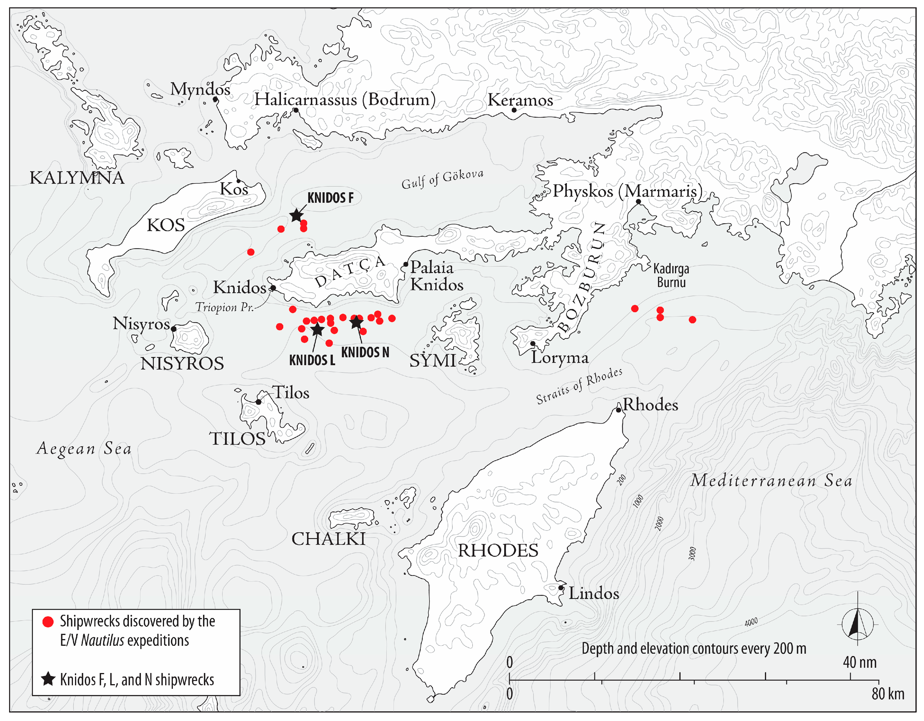
Figure 1. Map of the locations of Knidos F, Knidos L and Knidos N shipwrecks off the coast of the Datça Peninsula. Map: Dan Davis.
Heritage 09 00216 g001
Figure 2. Mosaic of the Knidos F shipwreck off the Datça Peninsula. Mosaic: Ocean Exploration Trust.
Heritage 09 00216 g002
Figure 3. Two representative views of Günsenin Type I amphorae on the Knidos F site.
Heritage 09 00216 g003
Figure 4. Mosaic of the Knidos L shipwreck off the Datça Peninsula. Mosaic: Ocean Exploration Trust.
Heritage 09 00216 g004
Figure 5. The primary amphora type at Knidos L site is Günsenin’s Type I.
Heritage 09 00216 g005
Figure 6. Secondary amphora type at Knidos L site.
Heritage 09 00216 g006
Figure 7. Mosaic of the Knidos N shipwreck. Mosaic: Ocean Exploration Trust.
Heritage 09 00216 g007
Figure 8. Primary amphora type at Knidos N site.
Heritage 09 00216 g008
Figure 9. Secondary amphora type at Knidos N site.
Heritage 09 00216 g009
Disclaimer/Publisher’s Note: The statements, opinions and data contained in all publications are solely those of the individual author(s) and contributor(s) and not of MDPI and/or the editor(s). MDPI and/or the editor(s) disclaim responsibility for any injury to people or property resulting from any ideas, methods, instructions or products referred to in the content.