


Abstract
Satellite remote sensing has rapidly evolved from an experimental support tool into a structural component of preventive archaeology and cultural heritage governance. Drawing on scientific publications and policy-oriented grey literature from 2010–2025, this study provides an integrated review of how optical, SAR, and multi-sensor satellite data are used to detect archaeological sites, monitor landscape and structural change, and support risk-informed planning across diverse legal and institutional contexts. A multi-platform workflow combines AI-assisted semantic querying (Consensus), bibliometric searches (Scopus), and the collaborative management and geospatial visualisation of references through Zotero, VOSviewer (1.6.19), and QGIS (3.44)-based literature mapping, thereby linking thematic trends, co-authorship networks, and geographical patterns of research and regulation. The results show non-linear but marked publication growth, a strongly interdisciplinary profile, and the consolidation of international hubs that drive advances in Sentinel-2-based prospection, Landsat and night-time lights urbanisation metrics, and SAR time series for deformation, looting, and conflict-damage mapping. Parallel analysis of grey literature and institutional initiatives (Copernicus Cultural Heritage Task Force, national “extraordinary plans”, regional declarations, and UNESCO guidelines) reveals the codification of satellite Earth observation within rescue archaeology protocols, emergency archaeology, and long-term conservation strategies. Overall, the evidence indicates a transition towards data-driven, multi-sensor, and multi-scalar research, underpinned by open satellite data, reproducible workflows, and AI-supported evidence synthesis.
1. Introduction
Rescue archaeology, frequently referred to as development-led archaeology and, in Franco-Italian literature, as archéologie préventive, has become an essential component of contemporary cultural heritage management globally. This field operates at the intersection of modern infrastructural development and the imperative to safeguard the archaeological record, representing a critical challenge in spatial planning and environmental design [1]. No longer merely reactive “rescue”, it has evolved into a sophisticated planning instrument designed to diagnose and mitigate the impacts of land-use changes prior to construction works.
The terminology itself reflects divergent philosophies. The shift from rescue archaeology to preventive archaeology signals a conceptual reorientation from emergency response to integrated risk management. In the Anglophone tradition, terms such as commercial archaeology explicitly acknowledge the market-based mechanisms that structure the sector. By contrast, Cultural Resource Management (CRM), prevalent in North America, positions the discipline within regulatory compliance frameworks. These distinctions encode deep-seated differences in how societies value heritage and negotiate the balance between preservation and development. Within this ecosystem, the engagement of local communities and municipal administrations has assumed pivotal importance. Participatory mapping initiatives have reshaped the discipline. Empowering communities as active stakeholders enables local inhabitants to influence research agendas and contribute directly to the sustainable management of cultural and landscape heritage [2,3].
Contemporary strategies increasingly prioritise non-invasive assessment, moving beyond trial trenching to embrace high-resolution remote sensing and GIS-based risk modelling. Satellite remote sensing has become a fundamental tool, enabling the detection, monitoring, and protection of archaeological sites globally [4,5,6,7]. The availability of open-access data from the Sentinel-1 and Sentinel-2 missions within the Copernicus programme has profoundly transformed archaeological monitoring, making advanced methodologies accessible even in resource-constrained contexts [7,8,9,10,11].
This research aims to present an updated and critical synthesis of recent scientific and methodological advances in satellite remote sensing for preventive archaeology; to identify emerging trends and international best practices; and to delineate current knowledge gaps, technological limitations, and forthcoming operational and regulatory challenges. A structured literature review was undertaken using specialised platforms, covering the period 2010–2025 and combining bibliometric methods with thematic exploration to provide a comprehensive overview of the potential and constraints of satellite remote sensing in supporting the protection of archaeological and cultural heritage (CH) within the evolving context of artificial intelligence.
2. Materials and Methods
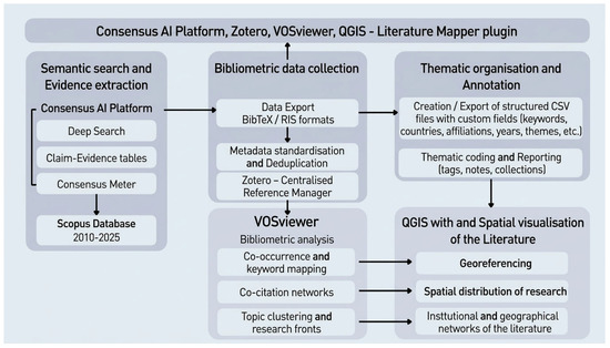
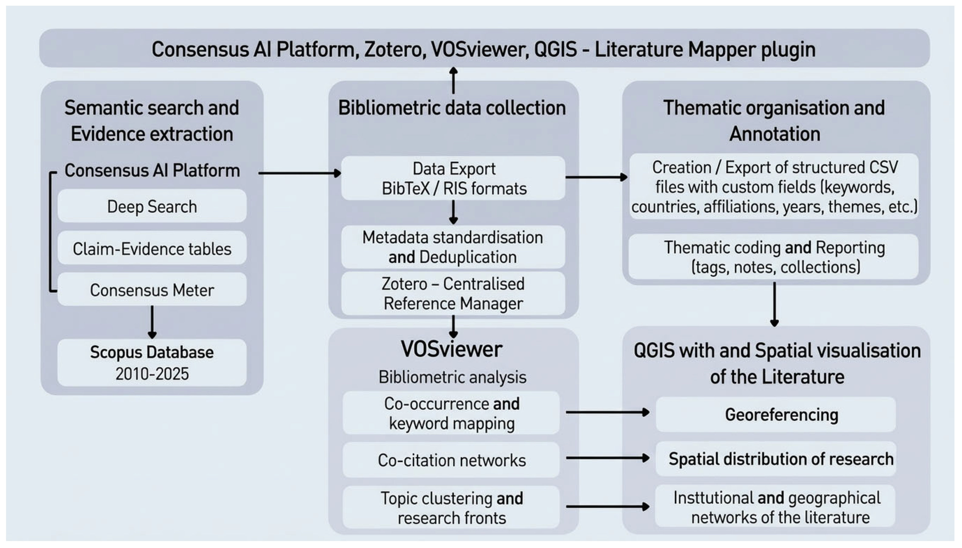
The bibliographic research employed an integrated, multi-source approach to cover peer-reviewed scientific literature and grey literature (technical reports, institutional guidelines, policy documents) spanning the period 2010–2025 (Figure 1). The methodological workflow coordinated three complementary platforms: Consensus, Scopus, and Zotero (6.0.36).
Figure 1.
The flowchart of this research.
Consensus, an AI-powered platform specialising in semantic search and evidence extraction from peer-reviewed literature, represents a methodological innovation [12]. Unlike traditional bibliographic search engines, Consensus answers natural language questions by querying a database of over 220 million scientific articles without requiring exact keyword matching. The platform employs artificial intelligence models (GPT-4, ELSER—Elastic Learned Sparse Encoder) to conduct contextual semantic searches, generate automated syntheses, and provide the Consensus Meter, which visualises the degree of agreement within the scientific literature.
Scopus was employed as a comparative bibliometric source to quantify scientific production between 2010 and 2025. Search strings were formulated to capture publications on satellite remote sensing applied to preventive archaeology, heritage protection, the looting of archaeological sites, and the monitoring and conservation of cultural assets. The retrieved records were exported in standard bibliographic formats (BibTeX, RIS) to enable bibliometric analyses (temporal trends, disciplinary distribution, funding patterns) and subsequent integration into Zotero. Zotero served as the central reference management environment, aggregating records from Consensus, Scopus, and grey literature retrieved from institutional databases and archival repositories. Within Zotero, references were organised hierarchically by topic and document type, enhancing source traceability, critical annotation, and the generation of structured bibliographic outputs. The complete set of metadata (authors, year, abstract, DOI, keywords) supported qualitative thematic analysis and the compilation of synoptic summary tables.
2.1. Data Collection: AI-Based Approach Using the Consensus Tool and Bibliometric Analysis
The Consensus application was employed in the first step. The Deep Search function enabled automated and iterative analyses of complex research questions, generating detailed syntheses that included claim–evidence tables, assessments of evidence strength, and the identification of research gaps. This approach significantly accelerated the exploratory phase, facilitating the rapid mapping of the research landscape and the identification of widely cited contributions.
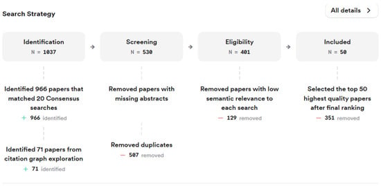
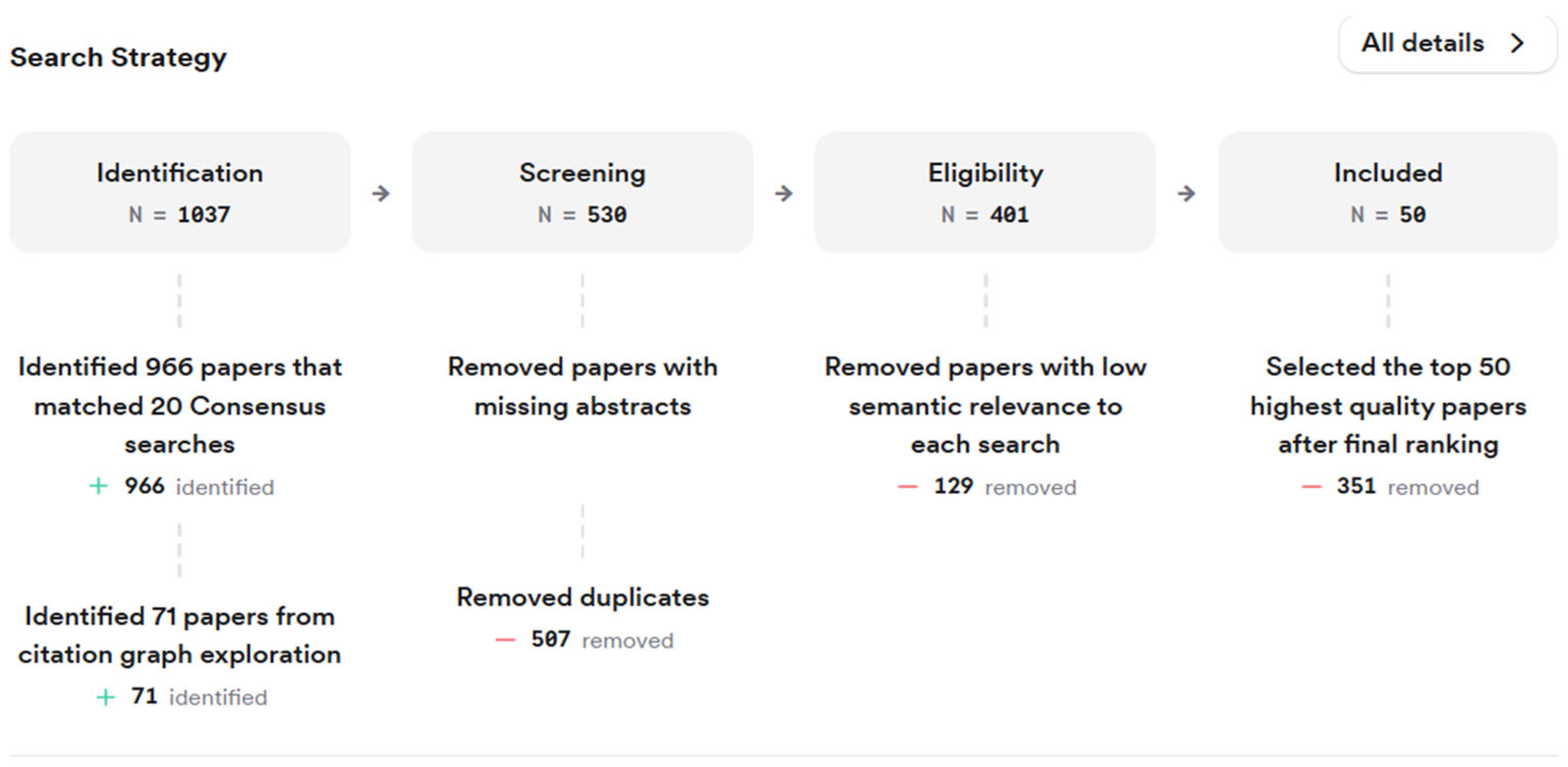
Consensus also provides filters that refine both the set of retrieved papers and the studies underpinning its summaries, thereby making searches more targeted and reproducible (Figure 2). Filters were applied to restrict publication years to the period 2010–2025 and to focus on specific disciplinary domains, namely Agricultural and Food Sciences, Art, Environmental Science, Geography, Geology, and History. Where possible, priority was given to higher-quality journals. The SCImago Journal Rank (SJR) was used to assess the relative influence of journals within each subject area. Journals are classified into four quartiles, with Q1 representing the top 25% and Q4 the bottom 25% in terms of prestige and citation impact. Additional filters were applied to narrow the search by study design (e.g., trials, observational studies, reviews) and by indicators of quality and influence, such as peer-review status and citation counts. In more recent versions, country and study-duration filters were also available, allowing a focus on geographical contexts and short- versus long-term studies [13].
Figure 2.
PRISMA flow diagram illustrating the Consensus search and selection strategy.
Consensus was used to rapidly identify specific claims and evidence on the topics under investigation, typically considering 20–50 papers per query. Principal queries included:
- “Remote sensing in preventive archaeology”;
- “Remote sensing from satellite in archaeology from 2015 to present with focus on Europe and North Africa”;
- “Remote sensing from satellite in preventive archaeology in the world”;
- “Can satellite remote sensing effectively prevent archaeological site looting?”;
- “Satellite remote sensing in cultural heritage protection and rescue archaeology”.
Scopus was subsequently queried to validate and complement the findings identified through Consensus. Three search strings were employed. In particular, Query 3 expands the search by considering the relationship between satellite remote sensing and the broader grouping of cultural heritage and archaeological evidence:
Query 1: (TITLE-ABS-KEY (“satellite remote sensing”) AND TITLE-ABS-KEY (“cultural heritage” OR archaeology OR “heritage protection” OR “looting at archaeological sites”) AND TITLE-ABS-KEY (preventive OR rescue OR monitoring OR conservation)) AND PUBYEAR > 2010 = 37.
Query 2: (TITLE-ABS-KEY (“satellite remote sensing”) AND TITLE-ABS-KEY (“cultural heritage” OR archaeology OR “heritage protection” OR “looting at archaeological sites”) AND TITLE-ABS-KEY (preventive OR rescue OR monitoring OR conservation) AND TITLE-ABS-KEY (“grey literature” OR report OR guideline OR “white paper” OR “policy document”)) AND PUBYEAR > 2010—only four results.
Query 3: TITLE-ABS-KEY (“cultural heritage” OR archaeol* OR “archaeological site*” OR “historic monument*”) AND (“remote sensing” OR “satellite remote sensing” OR “satellite imagery” OR “space-borne” OR “spaceborne” OR “space-borne SAR” OR “spaceborne SAR”) AND satellite*) AND (PUBYEAR > 2010).
2.2. Grey Literature Data
Moreover, the examination of so-called grey literature [5,14] provides an initial overview of the different approaches adopted in various countries through technical documents and legislative decrees and offers insight into global trends in the study of threats to cultural heritage arising from both anthropogenic and natural hazards, as well as into the use of remote sensing in preventive protection phases. Numerous national and regional archaeological and space agencies have developed extensive archives and operational workflows that exploit satellite data, including Synthetic Aperture Radar (SAR) and multispectral imagery, in support of archaeological prospection and site protection. These institutions provide access to high-resolution imagery, both archival and newly acquired, enabling long-term monitoring and rapid responses to emerging threats. International collaborative projects, particularly between European and Chinese institutions, have encouraged the sharing of technical expertise and operational protocols, especially in the use of SAR for cultural heritage applications, and this progress is supported by open-access platforms such as the Copernicus Sentinel missions and Google Earth Engine, which democratise access to big data for large-scale heritage management. Particular attention was devoted to the inclusion of policy documents and grey literature, using specific filters such as grey literature, report, guideline, white paper, and policy document.
For the exploratory phase of grey literature, Consensus was queried with prompts such as:
- “Satellite remote sensing in cultural heritage protection and rescue archaeology in the grey literature”.
- “National or regional archaeology or space agency repositories focusing on satellite remote sensing in cultural heritage protection and rescue archaeology”.
These prompts were used to identify key claims, evidence, and policy-oriented documents (for example, reports, guidelines, institutional white papers) that are often under-represented in conventional bibliographic databases.
To complement and organise these findings, Scopus was then used to retrieve publications explicitly referring to grey literature related to satellite remote sensing in preventive and rescue archaeology. The following search string was applied:
Query 3: (TITLE-ABS-KEY(“grey literature” OR “white papers” OR “technical reports” OR “policy documents”) AND TITLE-ABS-KEY(“satellite remote sensing”) AND TITLE-ABS-KEY(“preventive archaeology”) AND TITLE-ABS-KEY(rescue archaeology OR “cultural heritage protection”)) AND PUBYEAR > 2010.
2.3. Data Analysis
Moreover, VOSviewer is widely used to construct and visualise bibliometric networks such as co-authorship, co-citation, and keyword co-occurrence maps, relying on the VOS (visualisation of similarities) mapping technique and an associated clustering method developed by [15,16]. Starting from a co-occurrence or citation matrix, the software derives a similarity matrix between item pairs and computes a two-dimensional layout by minimising an objective function defined as a weighted sum of squared Euclidean distances; items with higher similarity receive larger weights and are therefore positioned closer together in the map. The optimisation problem is solved numerically through a majorisation procedure, a variant of the SMACOF algorithm used in multidimensional scaling, and is typically run with multiple random starts in order to reduce the risk of convergence to a poor local minimum.
For community detection, VOSviewer uses its own VOS clustering approach, which maximises a modularity-type quality function and is optimised by the smart local moving algorithm proposed by [15,16]. The number and granularity of clusters are controlled by a resolution parameter, with higher values yielding a larger number of finer clusters, while settings such as the number of iterations, random starts, and the minimum cluster size influence the stability and level of detail of the resulting partition. Additionally, VOSviewer provides density and cluster-density views by applying a Gaussian kernel smoothing function to the spatial distribution of items, weighting each point by its occurrence or co-occurrence frequency to highlight areas of high bibliometric density.
Zotero’s export tools were employed to extract bibliographic data and construct tables in CSV format, facilitating the integration of structured reference data with spatial analysis workflows. Furthermore, Literature Mapper, an open-source QGIS plugin, was utilised to transfer bibliographic information from Zotero into the GIS environment [17], enabling the generation of geospatial maps that link author affiliations, research institutions, and publication patterns to their geographical distribution. This integration of reference management systems with GIS visualisation extends traditional bibliometric analysis by adding a spatial dimension, revealing how research networks and institutional collaborations cluster and are distributed across different regions and institutional landscapes.
This multi-platform approach combined the advantages of structured bibliometric searching (Scopus), semantic AI for rapid evidence-based synthesis (Consensus), and collaborative reference management (Zotero), complemented by geospatial analysis tools, ensuring comprehensive and rigorous coverage. The integration of Consensus represents a methodological advance over traditional reviews, offering semantic synthesis capabilities, citation transparency, and iterative querying to progressively refine understanding of the domain. The addition of tabular data structuring and QGIS-based cartographic representation further enhances the research workflow by connecting bibliometric patterns to geographical and institutional contexts.
3. Results
3.1. Results of the Literature Assessment
The analysis of several charts produced from the dataset compiled in Zotero and populated through Consensus and Scopus queries, provides an insightful overview of the evolution and interdisciplinary character of scientific research on preventive archaeology using remote sensing and digital technologies (cf. Appendix A.1).
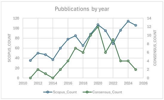
From a chronological perspective (Figure 3), the documents span the period 2010–2025 and reveal an overall upward trend up to 2020, followed by fluctuations in subsequent years. The Scopus series shows two main peaks, in 2020 and 2024, when the number of publications reaches its highest levels. The interval 2015–2020 is characterised by a phase of sustained growth, indicating a progressive intensification of publishing activity and scholarly attention to these topics. In the curated corpus (Consensus app sources), the trend is partially similar but more concentrated, with a marked increase between 2016 and 2020 and a peak in 2020, followed by a gradual decline after 2022. The most recent years display a contraction in the number of documents in the curated selection, which may reflect contingent factors such as the closure of specific projects, changes in research priorities, or the time needed for new studies to be included in the curated bibliography. Overall, the temporal pattern is non-linear, with alternating phases of expansion and contraction that mirror the evolution of scholarly output over time in both datasets.
Figure 3.
Publications by year: comparison of Scopus and Consensus results.
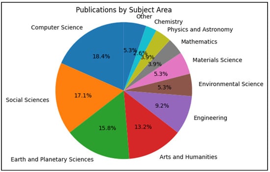
The second item (Figure 4) shows the percentage distribution of documents by subject area. The markedly multidisciplinary nature of the field becomes evident: the largest share is attributed to computer science (18.4%), reflecting the growing relevance of algorithms, digital models, and machine learning techniques for the processing and analysis of archaeological data. This is followed by the social sciences (17.1%) and Earth and Planetary Sciences (15.8%), which play a key role in risk studies, heritage conservation, and historical reconstruction. The substantial contribution of arts and humanities (13.2%) is also noteworthy, indicating that digital and remote sensing methodologies are increasingly integrated with humanistic approaches for historical documentation and cultural valorisation. Additional areas such as engineering, environmental sciences, and materials science confirm that the field benefits from a broad spectrum of cross-cutting expertise.
Figure 4.
Publications by subject area.
Within this multidisciplinary context, the overlay visualisation of co-authorship patterns reveals a close correspondence between the network structure and the geography of research funding (see Appendix A.1). The Cyprus University of Technology and the Institute for Mediterranean Studies (IMS-FORTH) emerge as key hubs, with Agapiou, Hadjimitsis, Lysandrou, Themistocleous, and Sarris anchoring dense collaboration clusters that reflect repeated participation in European framework programmes. A second pole comprises Italian public research bodies, notably CNR (IMAA, ISPC, ISAC) and the Universities of Siena, Padova, and Basilicata, where authors such as Lasaponara, Masini, and Cigna bridge methodological work in satellite data analysis with Mediterranean applications, mirroring Italian and European funding devoted to cultural heritage monitoring and integrated GIS–remote sensing platforms. A third, cohesive block is formed by the Chinese Academy of Sciences, which emphasises methodological innovation and large-scale Earth-observation datasets; although thematically close to European groups, this cluster appears more peripheral, suggesting different funding priorities and a less direct focus on Mediterranean case studies.
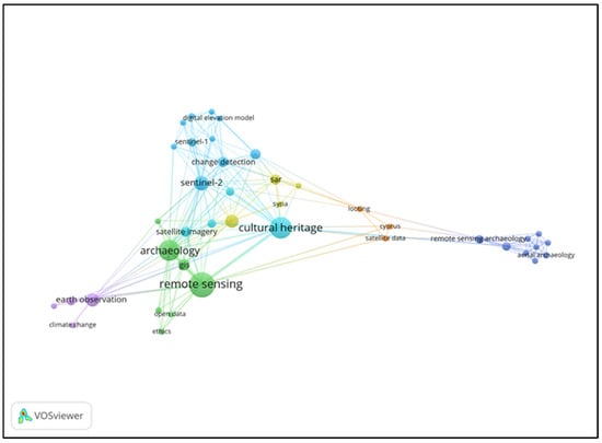
The network visualisation (Figure 5), instead, is based on keyword occurrences and depicts a research field structured around the use of remote sensing in archaeology and cultural heritage protection. Central nodes such as “remote sensing”, “archaeology”, and “cultural heritage” form the main hub, indicating a sustained focus on the application of Earth-observation techniques to the documentation and safeguarding of archaeological assets. These terms are tightly linked to methodological keywords, including “GIS”, “open data”, and “risk assessment/monitoring”, which function as bridging concepts connecting technical procedures with heritage-management practices.
Figure 5.
Network visualisation of keyword occurrences and co-occurrences derived from the reviewed literature.
Around this core, distinct clusters capture technical developments in satellite-and SAR-based approaches, with nodes such as “change detection”, “Sentinel-1”, “Sentinel-2”, “Cosmo-SkyMed”, and “digital elevation model” associated with dense connectivity, signalling a coherent subfield focused on advanced imaging and quantitative analysis. Additional groups relate these methods to monitoring tasks and climate-related risks, with terms such as “earth observation”, “climate change”, “UNESCO”, “Syria”, “Cyprus”, and “looting” extending the network to issues of environmental pressure, conflict, and illicit activities.
The structure and linkage patterns portray a mature yet evolving domain in which methodological innovation in remote sensing is closely coupled with preventive archaeology and heritage risk management. Technical, ethical, and geopolitical dimensions are increasingly integrated within a single, highly interconnected knowledge network. This integration reflects the complexity of contemporary heritage protection, where satellite-based monitoring must address not only natural environmental threats but also human-driven risks, including looting, unauthorised development, and conflict-related damage. The prominence of terms such as “UNESCO” and “Valletta Convention” indicates that this technical development occurs within an established regulatory and normative framework, while regional nodes such as “Syria”, “Cyprus”, and “North Africa” underscore the global relevance of satellite remote sensing for heritage protection in politically sensitive and geographically challenging contexts.
3.2. Overview of the Grey Literature
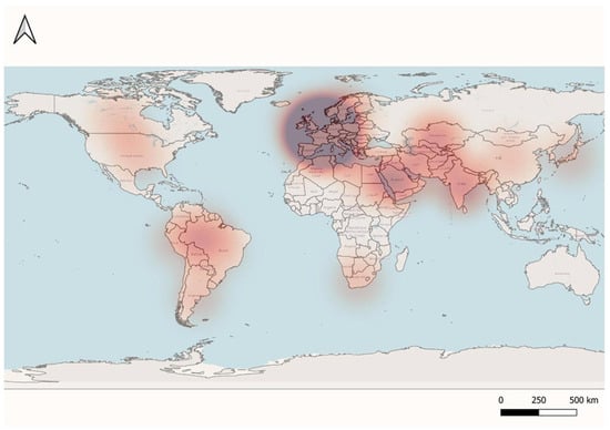
With regard to the findings emerging from the analysis of scientific and sector-specific literature, a complex and variegated picture arises concerning the application of satellite remote sensing within the contexts of preventive or rescue archaeology (cf. Section 3.1). As observed, this complexity is significant in terms of the disciplinary areas involved and the networks established between authors and research centers or universities. However, it is incumbent upon the authors to highlight, within this framework, the relationship between this type of research and the so-called grey literature, namely technical reports or legislative documents produced by the various cultural institutions that play a role, in different capacities, in the processes of cultural heritage management and safeguarding (Appendix A.2). Indeed, applying an analytical approach to these documents, analogous to that employed for scientific literature (cf. Section 2.2), has led to the identification of a specific geography of grey literature (Figure 6).
Figure 6.
The heatmap of so-called grey literature.
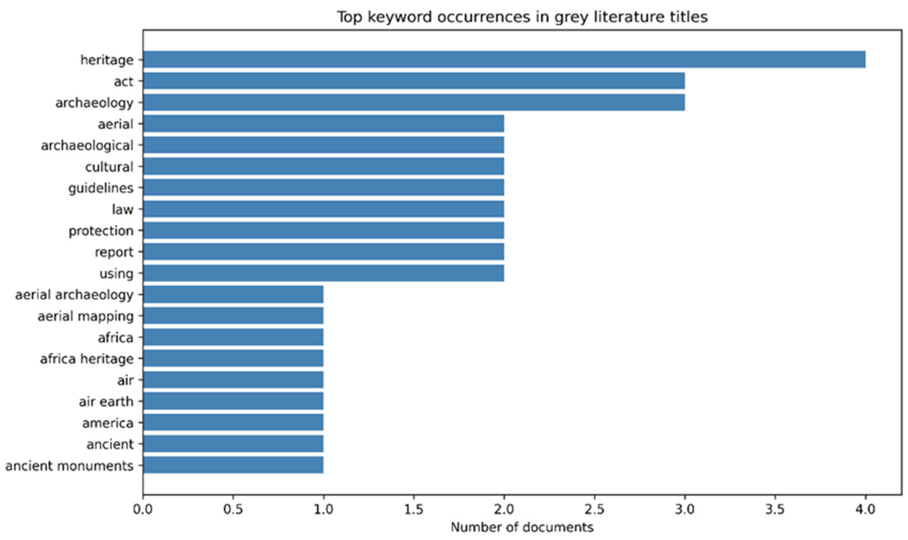
Starting from the work of Cuca et al. (2023) [5] and an extensive review of both scientific and grey literature, current practice shows that national and regional heritage and space agencies are progressively institutionalising the use of SAR and multispectral data for archaeological prospection, damage assessment, and long-term monitoring (Figure 7). Open-access infrastructures such as the Copernicus Sentinel missions and cloud platforms like Google Earth Engine underpin this shift by lowering access barriers to large Earth-observation datasets and enabling scalable, multi-temporal analyses in support of heritage management. International collaborations, particularly between European and Chinese institutions, have accelerated knowledge transfer on SAR-based techniques, operational workflows, and shared protocols, thereby consolidating remote sensing as a core instrument for diagnosing and managing threats arising from both anthropogenic and natural hazards.
Figure 7.
Keyword frequency in grey literature.
A major consolidated reference is the Copernicus Cultural Heritage Task Force Report, established under the Copernicus User Forum and coordinated by the Italian Ministry of Culture, which evaluates how Copernicus data and services can support the monitoring, management, and protection of cultural heritage. The report adopts a broad definition of cultural heritage that spans tangible, intangible, natural, and digital dimensions and situates heritage protection within wider policy frameworks, including the European Year of Cultural Heritage, the Sendai Framework for Disaster Risk Reduction, and EU resilience strategies. It identifies user needs across nine macro-domains—from environmental observation and cultural landscape mapping to non-destructive archaeological analysis, structural monitoring, emergency response, and public access—and maps them onto Copernicus Land, Atmosphere, Climate, Emergency, and Security services. The analysis underlines the particular effectiveness of land monitoring products for vegetation, water, and ground-motion indicators, while highlighting persistent gaps in spatial and temporal resolution, and proposes a roadmap centred on higher-resolution, higher-frequency products and tighter integration between satellite observations, in situ measurements, and information systems.
Within the European Union, these orientations are increasingly embedded in regulatory and planning tools for preventive archaeology, linked to environmental and heritage legislation. Satellite data from Sentinel-1 and Sentinel-2 are widely exploited for monitoring archaeological landscapes; quantifying risks such as erosion, ground deformation, and climate-related impacts; and detecting buried features in support of EU objectives for safeguarding cultural heritage. Environmental Impact Assessment and Strategic Environmental Assessment directives create a procedural framework in which archaeological evaluations—often supported by remote sensing—are required before major infrastructure or territorial development projects. The Horizon Europe and Marie Skłodowska-Curie projects have developed GIS platforms that integrate satellite imagery, geophysical sensors, and UAV data to automate risk assessment, vulnerability mapping, and site monitoring, generating hazard products that can be directly used by public authorities for preventive decision-making. European bodies also promote harmonised guidance and good-practice frameworks to align satellite data use among national agencies, archaeologists, and heritage managers, recognising the cost-effectiveness, repeatability, and scalability of these tools for routine monitoring and early-warning systems.
Italy provides a prominent example of national-scale institutionalisation through the “National extraordinary plan for the monitoring and conservation of immovable cultural heritage”, coordinated by the Ministry of Culture’s Directorate General for the Safety of Cultural Heritage. This plan extends the earlier risk map and, supported by the Mirror Copernicus programme, combines satellite services with UAVs and in situ sensor networks to build an integrated monitoring system for high-risk assets such as towers, bell towers, historic palaces, museums, and archaeological areas. Implementation proceeds through phases that include the creation of dedicated working groups, staff training, sensor installation, the development of a unified information system and dashboard linked to existing repositories, and the testing of multi-sensor workflows in pilot areas across Italy. The underlying logic is that reliable, frequently updated spatial data are indispensable for timely, proactive maintenance strategies that reduce long-term damage and restoration costs.
Other European countries show diverse but convergent trajectories. In Spain, the National Risk Management Plan for Cultural Heritage calls for a georeferenced cartographic inventory of cultural assets, including those with strong identity value, to support comprehensive risk mapping, although explicit references to satellite remote sensing remain limited. In the United Kingdom, guidance produced by Historic Environment Scotland advocates using advanced multispectral sensors, including infrared bands, to reveal hidden archaeological features, classify land cover, and monitor thermal anomalies, embedding remote sensing in digital documentation strategies. In France, INRAP has operationalised multi-sensor preventive archaeology workflows that integrate multispectral, hyperspectral, and thermal imagery; satellite LiDAR; and SAR with UAV photogrammetry for non-invasive detection, mapping, and monitoring prior to urban works or excavations. In Nordic countries, strict heritage legislation—such as Norway’s Cultural Heritage Act and Sweden’s Historic Environment Act—requires early identification, risk assessment, and site protection, and satellite remote sensing and geophysical methods are increasingly used to complement fieldwork, especially for large-area prospection and environmental monitoring, despite technical and climatic constraints.
Beyond Europe, satellite remote sensing is progressively woven into preventive archaeology regimes shaped by different legal and institutional traditions. In Central Asia, the 2021 Central Asian Declaration of the Principles of Archaeological Heritage Management, developed under UNESCO auspices, promotes collaborative protection practices and underpins the Central Asian Archaeological Legacy (CAAL) database, which consolidates recent and historical satellite imagery, historical cartography, and archival data in a shared geospatial platform. In East and South Asia, robust heritage laws in China, Japan, and India impose pre-construction archaeological investigations, and satellite imagery—optical and SAR—is increasingly employed as a non-invasive, large-scale means of locating buried remains, monitoring site conditions, and supporting legal compliance. In the Middle East, North Africa, and sub-Saharan Africa, regulations on antiquities, museums, and urban heritage often establish protection zones and strict permit regimes, while agencies use satellite imagery to delineate buffers, detect unauthorised activities, and track environmental changes that threaten sites. Regional initiatives such as EAMENA demonstrate how satellite-based inventories, integrated with ground surveys, can provide dynamic, up-to-date overviews of site conditions in support of both preventive and rescue archaeology.
Across the Americas, similar trajectories are emerging. In North America, the Archaeological Resources Protection Act in the United States, along with Canadian federal and provincial frameworks, requires archaeological assessments in advance of development and increasingly recognises satellite and aerial remote sensing as valuable non-invasive tools for early-stage screening and archaeological-potential mapping. In Canada, standards promulgated by institutions such as the National Capital Commission emphasise the early integration of archaeological considerations into design and environmental assessment, while recent practice incorporates multispectral and SAR data to detect and monitor sites in extensive or remote territories. In South America, national legislation in Brazil, Argentina, and Peru embeds preventive archaeological investigations in environmental licensing and major-works approvals, with Peru’s system of Certificates of No Archaeological Remains representing a particularly stringent model. Projects such as AmazonArch showcase the role of high-resolution optical imagery, LiDAR, and SAR in building vast georeferenced databases for Amazonian and Andean landscapes, enabling the detection of large-scale archaeological structures and the monitoring of threats such as deforestation, agricultural expansion, and mining. Nonetheless, persistent challenges in enforcement, funding, and stakeholder engagement can hinder the translation of satellite-derived insights into effective protective action on the ground.
At the global level, UNESCO provides the normative framework that explicitly positions satellite remote sensing as a strategic instrument for preventive archaeology. The 1972 World Heritage Convention, its Operational Guidelines, and related charters promote preventive conservation grounded in inventories, regular monitoring, strategic maintenance planning, and the integration of heritage management within broader land-use and environmental policies. Recent UNESCO publications and initiatives stress the advantages of Earth-observation technologies—particularly high-resolution optical imagery, SAR, and multispectral data—for non-invasive, cost-effective, and scalable surveillance of World Heritage and other sites, including the detection of land-use changes, ground instability, illegal construction, looting, and other threats. Collaborative programmes, such as the UNESCO-UNITWIN network and partnerships with space agencies, focus on research, capacity building, and knowledge exchange to mainstream remote sensing within heritage management practice worldwide.
Taken together, these regulatory developments and technical advances delineate a clear global trajectory towards data-driven, large-scale preventive archaeology in which satellite remote sensing is embedded within multi-level governance structures. While the degree of formalisation varies—from explicit legal mandates and national monitoring plans to de facto operational use within existing frameworks—the underlying trend is convergence towards integrated systems that combine satellite data, in situ observations, and information platforms to support evidence-based, sustainable cultural heritage management.
4. Discussion
Remote sensing has undergone rapid evolution within archaeological research and heritage management, moving from pioneering, fragmented applications to a systematic, multidisciplinary approach. Early work in the late twentieth and early twenty-first centuries demonstrated the potential of satellite and aerial imagery and emphasised the need for interoperable archives to share methods and results (Table 1). The spread of radar technologies, particularly Synthetic Aperture Radar (SAR) and interferometric techniques (InSAR), enabled continuous monitoring of sites regardless of weather or lighting conditions and supported risk assessment at UNESCO sites, in particular across Europe. The wide availability of Sentinel data, together with open-source platforms such as QGIS and Google Earth Engine, has since made archaeological monitoring more accessible and sustainable.
Table 1.
Synthesis of evidence from cited studies.
The combined use of the Consensus application and the validation of results against Scopus, both operating within a high-impact scientific landscape, enabled the construction of a focused reference bibliography on rescue archaeology and satellite remote sensing, framed within the broader context of cultural heritage and archaeological site protection. The resulting corpus of references, complemented by a review of grey literature identified through AI-assisted searches, broadened the evidential base and allowed the analysis to address a wider range of thematic and methodological issues (see Appendix A). Review studies on radar and optical applications have synthesised the current technological state of the art, drawing attention both to the potential and the limitations of imaging radar in cultural heritage contexts, particularly with regard to spatial resolution, revisit frequency, and scene complexity. Nonetheless, several authors emphasise that the uptake of these techniques remains uneven: research centres with advanced technical infrastructures and established monitoring programmes are far more likely to adopt them than institutions that continue to rely on traditional, largely descriptive approaches.
In recent decades, remote sensing has undergone rapid evolution within archaeological research and heritage management, transitioning from pioneering, fragmented uses to a systematic and multidisciplinary approach that combines optical, radar, and LiDAR data with GIS and three-dimensional modelling [18,19]. Early applications from the late twentieth and early twenty-first centuries highlighted the growing use of satellite and aerial imagery in archaeology and the need to develop interoperable, shared archives to disseminate methodologies and knowledge, as well as predictive models for site location and landscape reconstruction [20,21]. At the same time, the spread of radar technologies, particularly Synthetic Aperture Radar (SAR) and advanced PSI/SqueeSAR approaches, made it possible to carry out continuous and accurate monitoring of sites and structures, regardless of weather or lighting conditions and opened the way to systematic ground-deformation and stability analysis at cultural sites and cliff-bound monuments [22,23,24]. This process of technological maturation was subsequently extended through the use of interferometric data (InSAR) for risk assessment at UNESCO and other high-value sites across Europe and beyond, where the wide availability of Sentinel data and global open-data missions has enabled the creation of sustained monitoring programmes, early-warning systems, and multi-hazard assessments for protected areas [25,26]. From 2015 onwards, the accessibility of Sentinel-1/2 data and the rise of open-source software and platforms such as QGIS, Google Earth Engine, and low-cost aerial systems have marked a turning point in archaeological monitoring. A parallel strand of research has focused on the use of Landsat time series, night-time lights, and other global products to quantify anthropogenic pressure on archaeological landscapes and protected areas [27,28].
Several case studies have shown that this approach is more accessible and sustainable (Appendix A) and facilitates the integration of remote sensing into the workflows of preventive archaeology [29,30,31]. Indeed, an Italian case indicates that the integration of Sentinel-2 and open-source tools makes it possible to identify vegetation anomalies, indirect indicators of buried archaeological structures, while simultaneously documenting urbanisation dynamics and landscape impacts in regions such as Campania and Puglia, thereby aligning satellite evidence with preventive archaeology procedures [32]. In Romania, the same approach has been extended to Roman mining sites, where Sentinel-2 time series have been used to enable the early detection of erosion and landscape alteration and to provide a basis for risk identification in endangered archaeological areas and historic towns [33]. On a broader scale, similar methodologies have been replicated and expanded in Africa and the Middle East, where a combination of open-access data, Google Earth-based visual interpretation, and reproducible workflows compensates for the lack of systematic field surveys and supports multi-site monitoring of environmental and human risks, ranging from settlement dynamics to the exposure of archaeological landscapes [34,35,36]. At the same time, in the Paphos district of Cyprus, Landsat data and DMSP-OLS imagery have been employed to measure urban expansion and landscape fragmentation around UNESCO sites [37,38], while in the Luxor area, comparable techniques have demonstrated strong correlations between uncontrolled urbanisation, poor water management, and structural risk at temple complexes [39]. Subsequent work on Bagan, Myanmar, has shown how satellite data can support urban planning and help curb unregulated growth, thereby rendering remote sensing a strategic tool for heritage management and territorial governance; cognate studies on land-use changes, soil erosion, and protected-area monitoring further confirm the value of long time series for understanding cumulative impacts on cultural landscapes and heritage corridors [40].
Recent work has further expanded these approaches by developing machine learning workflows that integrate multi-source satellite data and large-scale cloud infrastructures. Drawing on open Sentinel-1 and Sentinel-2 imagery, machine learning pipelines have been used to detect damage, looting, and landscape change in conflict-affected archaeological areas through the combined use of spectral indices and interferometric analysis, relying entirely on open data and open-source code [41]. At the same time, advanced AI and deep-learning models have been systematically reviewed and benchmarked for archaeological site detection and change detection, highlighting both current capabilities and persistent gaps in training data and evaluation protocols [11,42]. These developments are embedded within broader digital frameworks that exploit petabyte-scale archives and platforms such as Google Earth Engine for cloud-based processing, ranging from heritage-focused applications [8,43] to global assessments of land-cover change and sustainability metrics across hundreds of World Heritage properties [44,45]. In parallel, large-scale literature and practice reviews have traced how such technologies are being adopted in Europe, documenting the growing but still uneven use of EO, machine learning, and AI for damage documentation, risk mapping, and operational decision support in cultural heritage management [5].
The integration of satellite data and Earth-observation tools is now an intrinsic component of management strategies at multiple scales, from national to supranational, reflecting increasing alignment with sustainability and risk-reduction policies promoted by several policy-makers, e.g., the European Union and UNESCO (see Section 3.2). In this regard, the Copernicus Cultural Heritage Task Force Report provides a European roadmap for enhancing Copernicus services in support of cultural heritage, underlining the need to integrate satellite observations, in situ measurements, geophysical surveys, and advanced information systems for predictive and sustainable management, and identifying specific user needs across domains such as environmental observation, structural monitoring, and emergency response. European experience reveals pronounced institutional differences but a shared orientation towards preventive archaeology models grounded in remote sensing techniques and digital documentation, as evidenced by national plans, sectoral guidelines, and research projects that systematise the use of Earth-observation data for cultural heritage risk assessment [46,47]. In Italy, the Ministry of Culture’s “National extraordinary plan for the monitoring and conservation of immovable cultural heritage” combines satellite data, UAV surveys, and in situ sensors within an integrated system for predictive diagnostics and maintenance of architectural and archaeological heritage, extending earlier “risk map” initiatives and linking heritage monitoring to the national space-economy strategy and Mirror Copernicus infrastructures [48]. In France, INRAP employs multispectral, hyperspectral, thermal, LiDAR, and SAR remote sensing technologies for both preventive and emergency archaeology, while in the United Kingdom, guidance produced by Historic Environment Scotland promotes multi-sensor documentation, three-dimensional recording, and condition monitoring in support of conservation strategies [49]. In Nordic countries and Spain, stringent legislative frameworks require preventive risk assessment—at times without explicit mention of remote sensing, but with increasing openness to the operational use of satellite, UAV, and geophysical methods—and foster the development of georeferenced inventories and risk maps for cultural assets [50,51].
Beyond Europe, remote sensing has also been progressively embedded within regulatory and institutional frameworks worldwide, often at the interface between heritage and environmental policies. In Asia, the UNESCO Declaration for Central Asia led to the creation of the CAAL database for satellite-based monitoring of archaeological sites, while recent legislative reforms in China and Japan have strengthened requirements for non-invasive preventive investigations prior to construction, within which satellite and aerial remote sensing now play an increasingly prominent operational role [40]. In India, Saudi Arabia, and North African countries, multispectral and SAR imagery is used to map and monitor archaeological areas at risk of deterioration, urbanisation, or looting, supporting authorities in risk management and feeding national or regional heritage risk observatories; large-scale initiatives such as EAMENA demonstrate how open-source satellite imagery and GIS can underpin inventories and change-detection analyses for endangered sites [35,52,53].
In the Americas, both North and South, remote sensing is embedded within legal frameworks that encourage the preventive conservation of archaeological sites, even when its use is not explicitly mandated in legislation (see the ARPA text). In the United States and Canada, satellite and aerial data are employed in impact assessments and cultural planning, in line with guidelines that promote the combined use of GIS and satellite imagery for predictive modelling and sensitivity mapping [54]. In South America—with notable cases in Brazil, Argentina, and Peru—national legislation requires preventive archaeological evaluations and increasingly relies on satellite and LiDAR data to identify and protect extensive areas of archaeological interest, such as Amazonian and Andean regions threatened by deforestation, extractive activities, and urbanisation [55,56]. UNESCO, through the 1972 World Heritage Convention and subsequent operational documents, has codified preventive conservation as a core principle, recognising remote sensing as a key tool for site monitoring and for implementing international protection standards, and encouraging the use of Earth-observation data in early-warning systems, damage assessments, and long-term conservation plans. SAR and multispectral imaging can detect environmental changes, degradation processes, and conflict-related damage without physically interfering with sites, thereby supporting informed and sustainable management, while initiatives such as the UNESCO-UNITWIN network and ICCROM programmes promote the dissemination of technical expertise [12], ethical guidelines, and good practice for remote sensing-based heritage monitoring in regions with differing levels of technological development. Taken together, the scholarly literature and institutional practice indicate a progressive convergence of scientific research, policy, and field operations: satellite remote sensing is no longer merely a diagnostic technology but has become a structural pillar of cultural heritage governance, consistent with global priorities for preventive conservation, sustainability, and community participation.
5. Conclusions
Satellite remote sensing has increasingly become a cornerstone of preventive archaeology and cultural heritage management, moving well beyond its early experimental applications. Since 2012–2015, highly cited contributions have shown how multi-sensor Earth observation, open-access data infrastructures, and AI-assisted analysis can support risk assessment, non-invasive diagnostics, and long-term monitoring across a wide range of contexts. Within this framework, Europe and North Africa have emerged as key laboratories of methodological innovation, combining optical and radar data, cloud platforms, and participatory approaches. At the same time, the field still shows marked asymmetries in technological access, divergent methodological choices, and uneven institutional uptake, all of which limit the comparability and transferability of results.
Against this evolving backdrop, the main research gaps appear at several levels and across the different categories analysed. There is a clear need to move towards more standardised and transparent workflows—from data acquisition and pre-processing through to classification, change detection, and validation—so that case studies can be meaningfully compared and reused. Likewise, the integration of artificial intelligence and machine learning remains partial and is coupled with significant gaps in processing capacity, technical expertise, and enabling infrastructure, a disparity that has been described as “geographical biases in remote sensing adoption” [57]. In parallel, the geography and typology of applications still tend to favour certain regions and types of sites, leaving many rural landscapes, underwater contexts, and so-called minor heritage sites relatively unexplored, even though these are precisely the areas where rescue archaeology has identified the greatest need for strengthening traditional research.
More generally, what is needed is a more systematic approach to satellite remote sensing for cultural heritage protection and rescue archaeology, one that is built around genuine interaction with diverse material cultures, historical periods, and community identities. This entails understanding how remotely detected indicators of change or damage acquire specific meanings in relation to local values and memories; adapting methods and interpretative frameworks to the characteristics of different archaeological traditions and environmental settings; and actively involving communities in the interpretation and use of satellite-derived information. Only by addressing these technical, institutional, and cultural dimensions will it be possible to develop remote sensing practices that are not only scientifically robust but also sensitive to the plurality of the identities and heritage narratives they seek to protect.
Author Contributions
Conceptualisation, C.S.D.S., N.M., and N.A.; methodology, C.S.D.S. and N.A.; software, C.S.D.S.; validation, C.S.D.S. and N.A.; formal analysis, C.S.D.S.; investigation, C.S.D.S. and N.A.; resources, N.M. and N.A.; data curation, C.S.D.S.; writing—original draft preparation, C.S.D.S.; writing—review and editing, N.M. and N.A.; visualisation, C.S.D.S. and N.A.; supervision, N.M. and N.A.; project administration, N.M. All authors have read and agreed to the published version of the manuscript.
Funding
This work was supported by the PNRR Project PE000020 ‘Cultural Heritage Active Innovation for Sustainable Society’ CHANGES, Spoke 5—Mission 4 Component 2, from research to enterprise; Investment Line 1.3—Extended partnerships extended to universities, research centres, enterprises and basic research project funded by the European Union—NextGenerationEU, National Recovery and Resilience Plan—CUP B53C22003890006.
Data Availability Statement
The data supporting the findings of this study are not stored in a separate repository but can be reproduced and retrieved by applying the search queries and filtering procedures described in Section 2 on the platforms Consensus and Scopus. All datasets used in this study are therefore accessible to readers through these publicly available services, subject to their access conditions.
Conflicts of Interest
The authors declare no conflict of interest.
Appendix A
Appendix A.1
- −
- Integrative bibliography from scientific literature analysis, providing additional references that complement those cited in the main text (cf. References):
- −
- Alders, W. Rural Settlement Dynamics in a Rapidly Urbanizing Landscape: Insights from Satellite Remote Sensing and Archaeological Field Surveys in Zanzibar, Tanzania. Journal of Field Archaeology 2024, 49, 634–652. https://doi.org/10.1080/00934690.2024.2402962.
- −
- Bonazza, A.; Bonora, N.; Duke, B.; Spizzichino, D.; Recchia, A.P.; Taramelli, A. Copernicus in Support of Monitoring, Protection, and Management of Cultural and Natural Heritage. Sustainability 2022, 14, 2501. https://doi.org/10.3390/su14052501.
- −
- Calderone, D.; Mangiameli, M.; Mussumeci, G.; Palio, O. Multispectral Satellite Imagery Processing to Recognize and Analyze Archaeological Sites in the Central Area of Sicily (Italy). Journal of Archaeological Science: Reports 2022, 44, 103514. https://doi.org/10.1016/j.jasrep.2022.103514.
- −
- Cerra, D.; Gege, P.; Evagorou, E.; Agapiou, A.; de los Reyes, R. Monitoring Marine Areas from the International Space Station: The Case of the Submerged Harbor of Amathus. In Proceedings of the Digital Heritage. Progress in Cultural Heritage: Documentation, Preservation, and Protection; Ioannides, M., Fink, E., Cantoni, L., Champion, E.; Springer International Publishing: Cham, Germany, 2021; pp. 127–137.
- −
- Chyla, J.M. How Can Remote Sensing Help in Detecting the Threats to Archaeological Sites in Upper Egypt? Geosciences 2017, 7. https://doi.org/10.3390/geosciences7040097.
- −
- Cigna, F.; Rayne L.; Makovics J. L.; Hope K. I; Jotheri J.; Algabri A.; Tapete D. Environmental Challenges and Vanishing Archaeological Landscapes: Remotely Sensed Insights into the Climate–Water–Agriculture–Heritage Nexus in Southern Iraq. Land 2025, 14, 1013. https://doi.org/10.3390/land14051013.
- −
- Costantini, M.; Francioni, E.; Trillo, F.; Minati, F.; Margottini, C.; Spizzichino, D.; Trigila, A.; Iadanza, C. PSP SAR Interferometry Monitoring of Ground and Structure Deformations Applied to Archaeological Sites.
- −
- Dana Negula, I.; Moise, C.; Lazăr, A.M.; Rișcuța, N.C.; Cristescu, C.; Dedulescu, A.L.; Mihalache, C.E.; Badea, A. Satellite Remote Sensing for the Analysis of the Micia and Germisara Archaeological Sites. Remote Sens. 2020, 12, 2003. https://doi.org/10.3390/rs12122003.
- −
- Davies, S.; Cabral, R.; Correia, M. Heritage Monitoring from Space: Evaluation of Satellite Remote Sensing for the Development of Early Warning Systems. In Science and Digital Technology for Cultural Heritage—Interdisciplinary Approach to Diagnosis, Vulnerability, Risk Assessment and Graphic Information Models; Ortiz Calderón, P.; Pinto Puerto, F.; Verhagen, P.; Prieto, A. Eds.; CRC Press: London, England, 2019.
- −
- Edwards, B.; Frasch, T.; Jeyacheya, J. Evaluating the Effectiveness of Land-Use Zoning for the Protection of Built Heritage in the Bagan Archaeological Zone, Myanmar—A Satellite Remote-Sensing Approach. Land Use Policy 2019, 88, 104174. https://doi.org/10.1016/j.landusepol.2019.104174.
- −
- Fradley, M.; Hardouin, S. Remote Sensing of Endangered Archaeology on Gebel Ataqah, Egypt. Palarch’s Journal of Archaeology of Egypt/Egyptology 2019, 16, 1–21.
- −
- Hobson, MS. EAMENA training in the use of satellite remote sensing and digital technologies in heritage management. Libyan Studies. 2019; 50, 63–71. https://doi.org/10.1017/lis.2019.22.
- −
- Khan, M.Y.; Zaina, F.; Abedin, Z. ul; Tariq, S.; Khan, M.J. Evaluation of Risks to UNESCO World Heritage (WH) Sites in Taxila, Pakistan Using Ground-Based and Satellite Remote Sensing Techniques. Journal of Cultural Heritage 2022, 55, 195–209. https://doi.org/10.1016/j.culher.2022.03.011.
- −
- Khan, M.Y.; Zaina, F.; Muhammad, S.; Tapete, D. Integrating Copernicus Satellite Products and Ground-Truthing for Documenting and Monitoring the Impact of the 2022 Extreme Floods in Pakistan on Cultural Heritage. Remote Sensing 2023, 15, 2518. https://doi.org/10.3390/rs15102518.
- −
- Kosta, A.; Paraskevopoulos, I.; Agapiou, A.; Battistin, F.; Serpetti, M.; Waldoch, F.; Rączkowski, W.; Iorio, A.D.; Angeli, S.D.; Hadjimitsis, D. Remote Sensing Techniques for Archaeology: A State of the Art Analysis of SAR Methods for Land Movement. In Proceedings of the Eighth International Conference on Remote Sensing and Geoinformation of the Environment, Cyprus, Greece, 26 August 2020.
- −
- Laugier, E.J.; Abdullatif, N.; Glatz, C. Embedding the Remote Sensing Monitoring of Archaeological Site Damage at the Local Level: Results from the “Archaeological Practice and Heritage Protection in the Kurdistan Region of Iraq” Project. PLOS ONE 2022, 17, 1–23. https://doi.org/10.1371/journal.pone.0269796.
- −
- Masini, N.; Lasaponara, R. Recent and Past Archaeological Looting by Satellite Remote Sensing: Approach and Application in Syria. In Remote Sensing for Archaeology and Cultural Landscapes: Best Practices and Perspectives Across Europe and the Middle East; Hadjimitsis, D.G., Themistocleous, K., Cuca, B., Agapiou, A., Lysandrou, V., Lasaponara, R., Masini, N., Schreier, G., Eds.; Springer International Publishing: Cham, Germany, 2020; 123–137.
- −
- Monteleone, A.; Dore, N.; Giovagnoli, A.; Cacace, C. VIDEOR: Cultural Heritage Risk Assessment and Monitoring on the Web. In Proceedings of the Fourth International Conference on Remote Sensing and Geoinformation of the Environment, Cyprus, Greece, 12 August 2016.
- −
- Tapete, D.; Cigna, F. COSMO-SkyMed SAR for Detection and Monitoring of Archaeological and Cultural Heritage Sites. Remote Sensing 2019, 11, 1326. https://doi.org/10.3390/rs11111326.
- −
- Tapete, D.; Cigna, F. Detection of Archaeological Looting from Space: Methods, Achievements and Challenges. Remote Sensing 2019, 11, 2389. https://doi.org/10.3390/rs11202389.
- −
- Tapete, D.; Cigna, F.; Donoghue, D.N.M. ‘Looting Marks’ in Space-Borne SAR Imagery: Measuring Rates of Archaeological Looting in Apamea (Syria) with TerraSAR-X Staring Spotlight. Remote Sensing of Environment 2016, 178, 42–58. https://doi.org/10.1016/j.rse.2016.02.055.
- −
- Tessema, T.; Naeini, M.M.; Azarmehr, N.; Benedetto, F.; Tosti, F. Integrating Satellite Remote Sensing and Ethical AI for Cultural Heritage Preservation. In Copernicus Meetings, Vienna, Austria, 27 April–2 May 2025.
- −
- Themistocleous, K.; Hadjimitsis, D.G.; Georgopoulos, A.; Agapiou, A.; Alexakis, D.D. Development of a Low Altitude Airborne Imaging System for Supporting Remote Sensing and Photogrammetric Applications ‘The ICAROS Project’ Intended for Archaeological Applications in Cyprus. In Proceedings of the Progress in Cultural Heritage Preservation; Ioannides, M., Fritsch, D., Leissner, J., Davies, R., Remondino, F., Caffo, R., Eds.; Springer: Berlin, Germany, 2012; pp. 494–504.
- −
- Zaina, F.; Cuca, B. Damages to Archaeological Heritage Recorded, Documented and Monitored Using Geospatial Technologies: An Assessment of Indexed Literature. In Proceedings of the 2022 IEEE Mediterranean and Middle-East Geoscience and Remote Sensing Symposium, Istanbul, Turkey, 2022.
Appendix A.2
Table A1.
References to so-called grey literature, available online (accessed on 20 January 2026).
References
- Manacorda, D. Archeologia Preventiva e Pianificazione Territoriale; Carocci: Roma, Italy, 2020. [Google Scholar]
- Álvarez Larrain, A.; McCall, M.K. Participatory mapping and participatory GIS for historical and archaeological landscape studies: A critical review. In Computational Approaches to Archaeological Spaces; Bevan, A., Lake, M., Eds.; Routledge: London, UK, 2019; pp. 643–678. [Google Scholar]
- Magnini, L.; Paladini, M.; Bergamo, M.; Paiano, J.; De Rossi, B.; Calcagno, M.; Calaon, D. Community Landscape Archaeology and Digital Technologies for Heritagization and Memorialization Processes. In Digital Heritage 2025; Eurographics—The European Association for Computer Graphics: Eindhoven, The Netherlands, 2025. [Google Scholar] [CrossRef]
- Luo, L.; Wang, X.; Guo, H.; Lasaponara, R.; Shi, P.; Bachagha, N.; Li, L.; Yao, Y.; Masini, N.; Chen, F.; et al. Google Earth as a Powerful Tool for Archaeological and Cultural Heritage Applications: A Review. Remote Sens. 2018, 10, 1558. [Google Scholar] [CrossRef] [Scilit]
- Cuca, B.; Zaina, F.; Tapete, D. Monitoring of Damages to Cultural Heritage across Europe Using Remote Sensing and Earth Observation: Assessment of Scientific and Grey Literature. Remote Sens. 2023, 15, 3748. [Google Scholar] [CrossRef] [Scilit]
- Lasaponara, R.; Masini, N. Satellite Remote Sensing in Archaeology. A New Tool for Archaeology; Springer: Dordrecht, The Netherlands, 2012. [Google Scholar]
- Agapiou, A.; Lysandrou, V. Remote Sensing Archaeology: Tracking and Mapping Evolution in European Scientific Literature from 1999 to 2015. J. Archaeol. Sci. Rep. 2015, 4, 192–200. [Google Scholar] [CrossRef] [Scilit]
- Agapiou, A. Remote Sensing Heritage in a Petabyte-Scale: Satellite Data and Heritage Earth Engine© Applications. Int. J. Digit. Earth 2017, 10, 85–102. [Google Scholar] [CrossRef] [Scilit]
- Tapete, D.; Cigna, F. Trends and Perspectives of Space-Borne SAR Remote Sensing for Archaeological Landscape and Cultural Heritage Applications. J. Archaeol. Sci. Rep. 2017, 14, 716–726. [Google Scholar] [CrossRef] [Scilit]
- Bonazza, A.; Sabbioni, C.; Messina, P.; Grossi, C.M. Earth observation for cultural heritage monitoring: From risk assessment to preventive conservation. Remote Sens. 2022, 14, 611. [Google Scholar] [CrossRef] [Scilit]
- Argyrou, A.; Agapiou, A. A Review of Artificial Intelligence and Remote Sensing for Archaeological Research. Remote Sens. 2022, 14, 6000. [Google Scholar] [CrossRef] [Scilit]
- Apata, O.E.; Kwok, O.-M.; Lee, Y.-H. The Use of Generative Artificial Intelligence (AI) in Academic Research: A Review of the Consensus App. Cureus 2025, 17, e87297. [Google Scholar] [CrossRef] [Scilit]
- Consensus. Welcome to Consensus. Available online: https://consensus.app/home/blog/welcome-to-consensus/ (accessed on 20 January 2026).
- The Operational Guidelines for the Implementation of the World Heritage Convention. Available online: https://whc.unesco.org/en/guidelines/ (accessed on 20 January 2026).
- Van Eck, N.J.; Waltman, L. Software survey: VOSviewer, a computer program for bibliometric mapping. Scientometrics 2010, 84, 523–538. [Google Scholar] [CrossRef] [Scilit]
- Van Eck, N.J.; Waltman, L. Visualizing bibliometric networks. In Measuring Scholarly Impact; Ding, Y., Rousseau, R., Wolfram, D., Eds.; Springer: Cham, Switzerland, 2014; pp. 285–320. [Google Scholar] [CrossRef] [Scilit]
- Tobias, M.M.; Mandel, A.I. Literature Mapper: A QGIS plugin for georeferencing citations in Zotero. Air Soil Water Res. 2021, 14, 11786221211009209. [Google Scholar] [CrossRef] [Scilit]
- Luo, L.; Wang, X.; Guo, H.; Lasaponara, R.; Shi, P.; Bachagha, N.; Li, L.; Yao, Y.; Masini, N.; Chen, F.; et al. Airborne and Spaceborne Remote Sensing for Archaeological and Cultural Heritage Applications: A Review of the Century (1907–2017). Remote Sens. Environ. 2019, 232, 111280. [Google Scholar] [CrossRef] [Scilit]
- Opitz, R.; Herrmann, J. Recent Trends and Long-Standing Problems in Archaeological Remote Sensing. J. Comput. Appl. Archaeol. 2018, 1, 19–41. [Google Scholar] [CrossRef] [Scilit]
- Custer, J.F.; Eveleigh, T.; Klemas, V.; Wells, I. Application of Landsat Data and Synoptic Remote Sensing to Predictive Models for Prehistoric Archaeological Sites: An Example from the Delaware Coastal Plain. Am. Antiq. 1986, 51, 572–588. [Google Scholar] [CrossRef] [Scilit]
- Campana, S.R.L. Mapping the Archaeological Continuum: Filling “Empty” Mediterranean Landscapes; Springer: Berlin, Germany, 2018. [Google Scholar]
- Ciampalini, A.; Raspini, F.; Frodella, W. Back Monitoring of the San Leo (Northern Italy) Rock Cliff by Means of SqueeSAR Technique. Rend. Online Soc. Geol. 2016, 41, 227–230. [Google Scholar] [CrossRef] [Scilit]
- Chen, F.; Guo, H.; Tapete, D.; Cigna, F.; Piro, S.; Lasaponara, R.; Masini, N. The Role of Imaging Radar in Cultural Heritage: From Technologies to Applications. Int. J. Appl. Earth Obs. Geoinf. 2022, 112, 102907. [Google Scholar] [CrossRef] [Scilit]
- Hadjimitsis, D.; Agapiou, A.; Alexakis, D.; Sarris, A. Exploring Natural and Anthropogenic Risk for Cultural Heritage in Cyprus Using Remote Sensing and GIS. Int. J. Digit. Earth 2013, 6, 115–142. [Google Scholar] [CrossRef] [Scilit]
- Tapete, D.; Cigna, F. InSAR Data for Geohazard Assessment in UNESCO World Heritage Sites: State-of-the-Art and Perspectives in the Copernicus Era. Int. J. Appl. Earth Obs. Geoinf. 2017, 63, 24–32. [Google Scholar] [CrossRef] [Scilit]
- Wang, Y.; Lu, Z.; Sheng, Y.; Zhou, Y. Remote Sensing Applications in Monitoring of Protected Areas. Remote Sens. 2020, 12, 1370. [Google Scholar] [CrossRef] [Scilit]
- Radočaj, D.; Obhođaš, J.; Jurišić, M.; Gašparović, M. Global Open Data Remote Sensing Satellite Missions for Land Monitoring and Conservation: A Review. Land 2020, 9, 402. [Google Scholar] [CrossRef] [Scilit]
- Zaina, F.; Tapete, D. Satellite-Based Methodology for Purposes of Rescue Archaeology of Cultural Heritage Threatened by Dam Construction. Remote Sens. 2022, 14, 1009. [Google Scholar] [CrossRef] [Scilit]
- Agapiou, A.; Lysandrou, V.; Hadjimitsis, D.G. Optical Remote Sensing Potentials for Looting Detection. Geosciences 2017, 7, 98. [Google Scholar] [CrossRef] [Scilit]
- Lindsay, I.; Mkrtchyan, A. Free and Low-Cost Aerial Remote Sensing in Archaeology An Overview of Data Sources and Recent Applications in the South Caucasus. Adv. Archaeol. Pract. 2023, 11, 164–183. [Google Scholar] [CrossRef] [Scilit]
- Żuk, L.; Królewicz, S. Uses of Sentinel-1 and -2 Images in Heritage Management: A Case Study from Lednica Landscape Park (Poland). Geosciences 2022, 12, 159. [Google Scholar] [CrossRef] [Scilit]
- Abate, N.; Lasaponara, R. Preventive Archaeology Based on Open Remote Sensing Data and Tools: The Cases of Sant’Arsenio (SA) and Foggia (FG), Italy. Sustainability 2019, 11, 4145. [Google Scholar] [CrossRef] [Scilit]
- Moise, C.; Dana Negula, I.; Mihalache, C.E.; Lazar, A.M.; Dedulescu, A.L.; Rustoiu, G.T.; Inel, I.C.; Badea, A. Remote Sensing for Cultural Heritage Assessment and Monitoring: The Case Study of Alba Iulia. Sustainability 2021, 13, 1406. [Google Scholar] [CrossRef] [Scilit]
- Cigna, F.; Balz, T.; Tapete, D.; Caspari, G.; Fu, B.; Abballe, M.; Jiang, H. Exploiting Satellite SAR for Archaeological Prospection and Heritage Site Protection. Geo-Spat. Inf. Sci. 2024, 27, 526–551. [Google Scholar] [CrossRef] [Scilit]
- Rayne, L.; Gatto, M.C.; Abdulaati, L.; Al-Haddad, M.; Sterry, M.; Sheldrick, N.; Mattingly, D. Detecting Change at Archaeological Sites in North Africa Using Open-Source Satellite Imagery. Remote Sens. 2020, 12, 3694. [Google Scholar] [CrossRef] [Scilit]
- Smith, R. Disasters and Archaeology: A Remote Sensing Approach for Determination of Archaeology At-Risk to Desertification in Sistan. Remote Sens. 2024, 16, 2382. [Google Scholar] [CrossRef] [Scilit]
- Agapiou, A.; Alexakis, D.D.; Lysandrou, V.; Sarris, A.; Cuca, B.; Themistocleous, K.; Hadjimitsis, D.G. Impact of Urban Sprawl to Cultural Heritage Monuments: The Case Study of Paphos Area in Cyprus. J. Cult. Herit. 2015, 16, 671–680. [Google Scholar] [CrossRef] [Scilit]
- Cuca, B.; Agapiou, A. Impact of Land-Use Change and Soil Erosion on Cultural Landscapes: The Case of Cultural Paths and Sites in Paphos District, Cyprus. Appl. Geomat. 2018, 10, 515–527. [Google Scholar] [CrossRef] [Scilit]
- Elfadaly, A.; Attia, W.; Qelichi, M.M.; Murgante, B.; Lasaponara, R. Management of Cultural Heritage Sites Using Remote Sensing Indices and Spatial Analysis Techniques. Surv. Geophys. 2018, 39, 1347–1377. [Google Scholar] [CrossRef] [Scilit]
- Zhao, Y.; Luo, L.; Wan, H.; Wu, Q.; Liu, C. Remote Sensing Monitoring and Analysis of Landscape Pattern in Bayanbulak Heritage Site for Nearly 30 Years. Natl. Remote Sens. Bull. 2022, 25, 2488–2506. [Google Scholar] [CrossRef] [Scilit]
- El Hajj, M. Interferometric SAR and Machine Learning: Using Open-Source Data to Detect Archaeological Looting and Destruction. J. Comput. Appl. Archaeol. 2021, 4, 47–62. [Google Scholar] [CrossRef] [Scilit]
- De Angeli, S.; Battistin, F.; Serpetti, M.; Di Iorio, A.; Valerio Moresi, F. The RESEARCH Project. Soil-Related Hazards and Archaeological Heritage in the Challenge of Climate Change. IOP Conf. Ser. Mater. Sci. Eng. 2020, 949, 012058. [Google Scholar] [CrossRef] [Scilit]
- Khalaf, N.; Insoll, T. Monitoring Islamic Archaeological Landscapes in Ethiopia Using Open-Source Satellite Imagery. J. Field Archaeol. 2019, 44, 401–419. [Google Scholar] [CrossRef] [Scilit]
- Guo, H.; Chen, F.; Tang, Y.; Ding, Y.; Chen, M.; Zhou, W.; Zhu, M.; Gao, S.; Yang, R.; Zheng, W.; et al. Progress toward the Sustainable Development of World Cultural Heritage Sites Facing Land-Cover Changes. Innovation 2023, 4, 100496. [Google Scholar] [CrossRef] [Scilit] [PubMed]
- Trovato, M.G.; Ali, D.; Nicolas, J.; El Halabi, A.; Meouche, S. Landscape Risk Assessment Model and Decision Support System for the Protection of the Natural and Cultural Heritage in the Eastern Mediterranean Area. Land 2017, 6, 76. [Google Scholar] [CrossRef] [Scilit]
- Almansa-Sánchez, J. Spaces for Creativity in Mediterranean Archaeological Heritage Management. Adv. Archaeol. Pract. 2020, 8, 275–287. [Google Scholar] [CrossRef] [Scilit]
- Pastura, G. I vantaggi e le innovazioni metodologiche del remote e del proximal sensing nel campo dell’Archeologia Preventiva: Sperimentazioni e risultati nell’ambito della verifica Preventiva dell’ Interesse Archeologico. GEOmedia 2024, 28, 36–38. [Google Scholar]
- Russo, A.; Della Giovampaola, I. Il Monitoraggio e La Manutenzione Delle Aree Archeologiche: Il Piano per Il Futuro del Parco Archeologico del Colosseo. In Proceedings of the Monitoraggio e Manutenzione delle Aree Archeologiche: Cambiamenti Climatici, Dissesto Idrogeologico, Degrado Chimico-Ambientale: Atti del Convegno Internazionale di Studi, Rome, Italy, 20–21 March 2019. [Google Scholar]
- Wilson, A. The Use of Remote Sensing and Digital Tools for Cultural Heritage Management and Archaeological Research. Levant 2021, 53, 384–388. [Google Scholar] [CrossRef] [Scilit]
- Boschi, F. Archeologia preventiva e indagini non invasive. Stato dell’arte in Italia e casi di studio. Atti Rass. Tec. Soc. Degli Ing. Degli Archit. Torino 2020, 74, 120–130. [Google Scholar]
- Pizzano, N.; Merola, P.; Di Giovanni, E. Archeologia preventiva a Pontelatone (CE): Nuovi dati sulle dinamiche insediative in prossimità del fiume Volturno. Archeol. Calc. 2018, 29, 201–222. [Google Scholar] [CrossRef] [Scilit]
- Fisher, M.; Fradley, M.; Flohr, P.; Rouhani, B.; Simi, F. Ethical considerations for remote sensing and open data in relation to the endangered archaeology in the Middle East and North Africa project. Archaeol. Prospect. 2021, 28, 279–292. [Google Scholar] [CrossRef] [Scilit]
- Copernicus Cultural Heritage Task Force. TF-CH—Report on the User Requirements in the Copernicus Domain to Support Cultural Heritage Management, Conservation and Protection. Available online: https://www.copernicus.eu/sites/default/files/2020-10/CC-2020-37_Copernicus-Cultural-Heritage-Task-Force-Report_0.pdf (accessed on 20 January 2026).
- Kempf, M. The Application of GIS and Satellite Imagery in Archaeological Land-Use Reconstruction: A Predictive Model? J. Archaeol. Sci. Rep. 2019, 25, 116–128. [Google Scholar] [CrossRef] [Scilit]
- Masini, N.; Lasaponara, R. Remote and Close Range Sensing for the Automatic Identification and Characterization of Archaeological Looting. The Case of Peru. J. Comput. Appl. Archaeol. 2021, 4, 126–144. [Google Scholar] [CrossRef] [Scilit]
- Lasaponara, R.; Danese, M.; Masini, N. Satellite-Based Monitoring of Archaeological Looting in Peru. In Satellite Remote Sensing. Remote Sensing and Digital Image Processing; Lasaponara, R., Masini, N., Eds.; Springer: Dordrecht, The Netherlands, 2012; Volume 16. [Google Scholar] [CrossRef] [Scilit]
- Davis, D.S. Geographic Disparity in Machine Intelligence Approaches for Archaeological Remote Sensing Research. Remote Sens. 2020, 12, 921. [Google Scholar] [CrossRef] [Scilit]

Disclaimer/Publisher’s Note: The statements, opinions and data contained in all publications are solely those of the individual author(s) and contributor(s) and not of MDPI and/or the editor(s). MDPI and/or the editor(s) disclaim responsibility for any injury to people or property resulting from any ideas, methods, instructions or products referred to in the content. |
© 2026 by the authors. Licensee MDPI, Basel, Switzerland. This article is an open access article distributed under the terms and conditions of the Creative Commons Attribution (CC BY) license.