


Abstract
Wat Phra Mahathat Woramahawihan (Wat Phra Borommathat), a UNESCO World Heritage site in Nakhon Si Thammarat, southern Thailand, is conventionally interpreted as a Theravada Buddhist monument; however, archaeological evidence suggests the presence of Mahayana influences within the complex. This study examines whether shared spatial characteristics between Theravada and Mahayana Buddhist traditions are embedded in the site’s spatial organization. Employing a qualitative, interpretive research design, the study integrates field observation, comparative literature review, and spatial analysis, drawing on major Buddhist monuments in Central Java—principally Borobudur and Candi Sewu—as comparative references. Four principal shared characteristics were identified: (1) site location closely associated with river systems originating from mountain ranges, which may reflect pan-Buddhist or Mahayana siting conventions; (2) a north-facing principal axis emphasizing the Bodhi tree, consistent with Theravada practice, later reoriented eastward under Ayutthaya influence; (3) a concentric three-row arrangement of satellite stupas that may be read as reflecting the Traibhumi cosmological hierarchy (a framework not exclusive to Mahayana); and (4) the original absence of a documented monastic precinct, a characteristic shared with Borobudur. These findings suggest that the spatial organization of Wat Phra Borommathat may transcend sectarian boundaries, without implying a direct transmission pathway, and point to possible connections to broader processes of cultural exchange and architectural adaptation across Southeast Asia. The study introduces the concept of “Layered Architectural Heritage” and affirms the value of spatial analysis as a methodological tool for studying religious architecture.
1. Introduction
Wat Phra Mahathat Woramahawihan, formerly known as Wat Phra Borommathat, is located in Nakhon Si Thammarat Province, Thailand. It is one of the most influential and significant religious sites in the upper southern region of Thailand. Archaeological excavations have revealed that Wat Phra Borommathat is more than one thousand years old [1,2,3,4], with the UNESCO documentation giving the 8th century as the date of its founding [5]. This Buddhist sacred site has long served as an important religious, cultural, and political center and was recently inscribed on the UNESCO World Heritage List [5] as a living site.
Beyond its local significance, this sacred site is also important at the regional level because it occupies a strategically significant location. As shown in Figure 1, Wat Phra Borommathat is situated almost precisely at the geographical center of southern Thailand and has access to both the Gulf of Thailand and the Andaman Sea. This location facilitated trade, travel, and cultural exchange [6]. Previous studies have confirmed that Nakhon Si Thammarat once functioned as a major commercial and administrative center in southern Thailand, with its sphere of influence possibly extending as far as northern Indonesia [7,8,9,10].
Figure 1.
Map illustration showing the location of Nakhon Si Thammarat Province within the Southern Region of Thailand. Administrative boundary data from GADM (2018); illustration by the author.
This locational advantage enabled Wat Phra Borommathat to facilitate the circulation and exchange of Buddhist cosmological beliefs, architectural knowledge, and ritual practices throughout Southeast Asia [11,12,13,14,15]. As indicated schematically in Figure 2, maritime trade routes and cultural interactions transmitted religious concepts and architectural forms, giving rise to comparable Buddhist spatial patterns across the region [6]. In this study, spatial similarity refers to the empirical co-occurrence of comparable architectural patterns at geographically separated sites, and is distinguished from evidence of direct cultural influence, which would require datable material evidence of transmission; the study claims the former, not the latter. These processes did not result in exact architectural replication; rather, they generated distinctive local architectural expressions through reinterpretation and hybridization adapted to specific cultural contexts [16,17,18].
Figure 2.
Schematic map of the Indian Ocean maritime trade network (c. 7th–14th century CE), showing principal sea routes connecting South Asia, mainland Southeast Asia, and the Malay Peninsula. Colored markers indicate the sites: Borobudur, Central Java (blue); Ananda Temple, Bagan (red); Wat Phra Borommathat, Nakhon Si Thammarat (green); Mihintale and Anuradhapura, Sri Lanka (purple); Nalanda, north-east India (gold). Line styles indicate the primary maritime route (dashed orange), the secondary exchange route (dotted green) and the overland/coastal link (solid purple); where two routes follow the same corridor, the lines are drawn together. Note: Routes are indicative only.
Architecturally, the focal point of Wat Phra Borommathat is the Great Reliquary, which consists of a principal stupa flanked by four corner stupas. A significant feature of this structure is its upper level, which functions as a circumambulatory walkway accessible to visitors—a spatial characteristic that facilitates religious rituals. While such configurations draw parallels with ancient Buddhist sites like Nalanda Mahavihara in India [4,5], the specific spatial utilization of the upper level at Wat Phra Borommathat is clearly demonstrated in Figure 3.
Figure 3.
Spatial utilization of the upper level of the Great Reliquary, demonstrating the architectural layout that allows for visitor access and circumambulation around the principal stupa. Annotations indicate the upper-level functional zone and access stairway. Photographs and annotations by the author.
In addition, the Great Reliquary is surrounded by three rows of satellite stupas, of which 149 remain today [19]. Such spatial arrangements can also be found at major Buddhist monuments in South and Southeast Asia, including Borobudur and Candi Sewu in Indonesia. The hierarchical arrangement of satellite stupas, consisting of smaller stupas systematically organized around a principal monument in a concentric configuration [20,21,22,23], represents an architectural ordering of primary and secondary elements derived from Buddhist religious concepts and expressed through the surrounding spatial organization. These similarities indicate shared spatial characteristics that transcend differences in Buddhist sectarian traditions and regional cultural contexts. They also suggest an approach to spatial design in which architectural elements served functions extending beyond their role as settings for Buddhist religious activities alone.
In addition to serving as a venue for monastic rituals, as is common in Buddhist temples, this site also functions as a civic center where various Buddhist traditions and ceremonies are regularly held. One such tradition is the Hae Pha Khuen That (relic cloth-draping ceremony). According to the earliest official records currently available, this tradition was explicitly documented during the reign of King Rama II of Siam, corresponding to 1817 CE [24,25]. This indicates that the tradition has been continuously practiced for more than 200 years. The long continuity of this tradition reflects the enduring role of the religious site and its ability to remain integrated into the daily lives of local communities across different historical periods.
Religious monuments are not merely physical structures; they also serve as manifestations of belief systems and facilitate performative and processional practices, transforming them into lived spaces that influence users and participants [26,27,28,29,30,31]. Furthermore, the belief that the Buddha’s relics are enshrined within the principal stupa reinforces the symbolic and cosmological significance of the monument as a center of sacred authority and devotional activity [32]. Key architectural characteristics common to Buddhist monumental traditions in South and Southeast Asia include: (1) the stupa or chedi as the primary reliquary structure representing the axis mundi; (2) mandala-based spatial organization, in which precincts and structures are hierarchically arranged around a central sacred axis; (3) circumambulatory paths enabling ritual procession (pradakshina) around the principal monument; (4) a clearly demarcated sacred boundary (sima) that consecrates and encloses the precinct; and (5) cardinal directional orientation that encodes cosmological symbolism into the physical layout of the site. These general features provide the background against which the four spatial characteristics examined in this study (water-system siting, principal axis and access direction, concentric satellite-stupa hierarchy, and the sacred versus monastic precinct) are analyzed in the Results section the Discussionare analyzed in Section 3 and interpreted in Section 4.
Studies of Wat Phra Borommathat have led many scholars to interpret “this site as a Theravada Buddhist monument” because the architectural and artistic characteristics found within the temple exhibit close affinities with the Sri Lankan Buddhist tradition. Although such interpretations contribute important insights into the architectural character of the monument, archaeological evidence indicates that the site also incorporates influences from earlier periods as well as parallel traditions associated with broader Buddhist practices throughout Southeast Asia [6,14,33]. For example, archaeological excavations have uncovered artifacts exhibiting Mahayana artistic characteristics within the temple complex [6,34].
This observation raises the question of whether “Wat Phra Borommathat may represent a Buddhist monument in which both Theravada and Mahayana architectural characteristics overlap.” Such complexity suggests that the site should be understood as the result of multiple overlapping developmental processes rather than as the expression of a single Buddhist tradition alone.
Based on this research question, confirming the possible presence of Mahayana architectural characteristics at the site may not be achievable through architectural form alone. This is because Wat Phra Borommathat has undergone numerous phases of restoration and reconstruction over more than a thousand years [19]. Evidence for this is provided by the discovery of brick layers dating to different periods [19,34]. Therefore, identifying surviving Mahayana architectural characteristics requires attention to architectural elements that are less susceptible to change, such as site planning. Furthermore, comparative observations reveal that certain characteristics, including the proportional relationship between the Great Reliquary and the uppermost stupa of Borobudur, appear remarkably similar [35,36]. This may be coincidental, or it may represent one indication of a broader correspondence between Wat Phra Borommathat and major Buddhist monuments in Central Java.
Spatial organization within Buddhist monuments in Central Java results from interactions among architecture, movement, environment, and Buddhist cosmological meanings. Contemporary scholarship increasingly interprets such spatial arrangements through the concept of sacred landscapes [37,38]. This system is shaped by ritual, topographical, and cultural factors, while architectural elements function as instruments through which these relationships are expressed [6,8]. This perspective is consistent with theoretical approaches that regard society and culture as fundamental factors in the production of space, rather than viewing space solely as a physical or formal phenomenon [26,27,32].
Within this conceptual framework, architectural forms cannot be fully understood solely through stylistic classification or sectarian affiliation. Instead, they must be analyzed as part of broader processes of cultural exchange and interpretation operating across regions and historical periods [6,39]. The recurrence of similar spatial arrangements in different geographical contexts suggests the circulation of shared architectural logics [6,8].
Accordingly, this study does not seek to interpret Wat Phra Borommathat as belonging exclusively to any particular Buddhist tradition. Rather, it examines these similarities as shared spatial characteristics resulting from factors that shape architecture, including culture, trade, and politics [6,7,8]. These factors facilitated the transmission of architectural forms within broader frameworks of religion and belief. The study therefore seeks to identify the fundamental principles that contributed to the formation of sacred Buddhist architecture in Southeast Asia.
To achieve this objective, the study employs a systematic spatial analysis of Wat Phra Borommathat, focusing on location, site planning, and patterns of spatial use, and compares these characteristics with those of major Buddhist monuments in the region, such as Borobudur. This approach makes it possible to identify recurring spatial patterns.
At the same time, it avoids potentially reductive interpretations by relying exclusively on recurring architectural patterns. This approach contributes to a more nuanced understanding of the architectural relationships between the two Buddhist traditions and highlights the importance of spatial analysis as a methodological tool for the study of religious architecture.
While existing scholarship has extensively documented the architectural forms, historical development, and ritual practices of Wat Phra Borommathat [1,2,3,4,14,19,34,36], and the UNESCO World Heritage documentation already recognizes the integration of Brahmanical, Hindu, Mahayana, and Theravada influences at the site, including those from Central Java [5], to the authors’ knowledge, no study has previously applied a systematic site-plan and urban-scale spatial analysis to identify where, within the monastery and its urban setting, Mahayana-related spatial characteristics overlap with its Theravada layers, and whether the site’s organizational principles share structural logic with Mahayana monuments in Central Java. Studies such as Wasiwiwat [14] and Wachiratienchai and Kirdsiri [19] focus on the Theravada and Ayutthayan phases of the temple’s development, while Brawn [25] examines contemporary monastic community life. The UNESCO World Heritage documentation establishes the plural religious character of the site: the Statement of Outstanding Universal Value under criterion (ii) cites Brahmanism, Hinduism, and both Mahayana and Theravada Buddhism, together with Central Javanese art, among the sources of the Great Reliquary’s combined architectural style, and the site was inscribed in 2026 (WHC 1761) under criteria (ii) and (vi) [5]. This study therefore treats the recognized Mahayana presence as its starting point, not as a finding. As reflected in the published World Heritage description [5], the recognition is framed in terms of heritage significance and artistic and architectural expression; it does not map which components of the site plan and its urban setting carry Mahayana-related overlaps. The research gap is accordingly one of spatial specificity, not of recognition: where within the site plan, access organization, and urban setting such overlaps can be documented, and where they cannot. By foregrounding site planning, access organization, spatial hierarchy, and functional zoning as the analytical units—rather than iconography or artistic style—this study opens a comparative dimension that existing literature on this site has not pursued. The originality of this research therefore lies in applying a spatial-analytical methodology—rather than iconographic or art-historical classification—to test whether the organizational logic of a major heritage site in southern Thailand converges with that of Mahayana monuments in Central Java, thereby contributing a new comparative framework to architectural heritage studies.
The research problem addressed here is therefore specific: the spatial logic of Wat Phra Borommathat has been described in historical, ritual, and art-historical terms, but it has not been compared systematically with the planning principles documented at Buddhist monuments elsewhere. Central Java is adopted as the comparative field for three reasons. First, its first-millennium Buddhist complexes are among the best-documented Buddhist spatial systems [20,21,22,23,40,41,42]. Second, the literature on maritime and peninsular exchange links the Thai–Malay Peninsula with Java and the wider Indian Ocean world [7,8,9,10,16,17,18]. Third, the published layouts of these monuments permit comparison on a small set of explicit spatial indicators (C1–C4, defined in Section 2.1). Selecting these monuments does not presuppose a historical relationship; whether any relationship exists is itself one of the questions examined.
Three research questions guide the analysis. RQ1: Which of the four spatial indicators (C1–C4) can be documented at Wat Phra Borommathat? RQ2: Which of these indicators have documented counterparts at Borobudur and, where the published sources allow, at Candi Sewu, Candi Lumbung, and Candi Plaosan? RQ3: To what extent can the observed correspondences be attributed to shared Buddhist spatial conventions rather than to geography, function, or other causes, and which historical mechanisms of exchange are plausible? The analytical framework that operationalizes these questions is summarized in Figure 4.
Figure 4.
Spatial analysis methodology framework, illustrating the multi-criteria analytical process from primary data sources through comparative criteria (C1–C4) to interpretive synthesis. C1, water-system siting; C2, principal axis and access direction; C3, concentric satellite-stupa hierarchy; C4, sacred versus monastic precinct. UNESCO sources: nomination dossier WHC 1761 (2026) [5]. Comparative cases: Borobudur, Candi Sewu, and Ananda Temple [43].
Furthermore, this study is consistent with contemporary developments in heritage studies, which emphasize the interpretation of cultural sites as layered and dynamic entities shaped by processes of interaction, transformation, and reinterpretation [14] (see Section 5 for the working definition of “Layered Architectural Heritage”). Rather than viewing cultural heritage as a static representation of the past, this research demonstrates the evolving role of heritage sites through time. By examining Wat Phra Borommathat within this analytical framework, the study presents new insights into the relationships among architecture, Buddhist cosmology, and cultural exchange in Southeast Asia.
2. Materials and Methods
This study employed a qualitative research design to examine the spatial organization and architectural characteristics of Wat Phra Borommathat within the broader context of Southeast Asia. The research focused on architectural characteristics that are relatively resistant to change, namely location, site planning, and patterns of spatial use, which can be systematically compared with other Buddhist monuments. This approach enabled the integration of architectural analysis with interpretations of religious and cultural meanings [13,44]. The study also incorporated analyses of site layout, spatial circulation, and symbolic organization in order to provide the clearest possible explanation and verification of the research findings.
2.1. Research Design
This research was structured as an interpretive architectural study integrating field observation with literature review. This approach made it possible to investigate spatial characteristics not only as physical elements but also as components embedded within broader cultural, symbolic, and religious frameworks [45,46].
The study sought to identify shared characteristics between Mahayana and Theravada Buddhism through interpretations of religious beliefs as expressed in architecture. A literature review was employed as the primary tool for identifying the distinctive characteristics of Mahayana architecture, with particular emphasis on studies of Buddhist monuments in Central Java. Monuments in this region are regarded as among the oldest and most original recorded examples of Mahayana Buddhist sacred architecture [20,21,22]. Following the literature review, the resulting dataset was subjected to comparative analysis with Wat Phra Borommathat in Nakhon Si Thammarat, Thailand, which is generally regarded as a Theravada monument [6,14,33] and represents the case study from which the research question emerged regarding the possible presence of Mahayana architectural characteristics in its spatial organization.
To operationalize this comparison, the study adopts the spatial characteristics of major Mahayana Buddhist monuments in Central Java—principally Borobudur, Candi Sewu, Candi Lumbung, and Candi Plaosan—as the comparative reference frame. These four monuments were selected because they represent the most thoroughly documented Mahayana Buddhist complexes in Central Java, with reliable spatial data on site layout, axial organization, water proximity, and boundary demarcation available in the peer-reviewed literature—precisely the four indicators employed in this study. Four spatial attributes, numbered 1 to 4 below and referred to hereafter as indicators C1 to C4 respectively, are treated as indicators derived from this corpus: (1) deliberate siting at or near confluent river systems flowing from mountainous terrain; (2) axial directional organization linking the principal monument to subsidiary structures; (3) concentric hierarchical arrangement of satellite stupas around a sacred center; and (4) spatial separation of sacred ceremonial space from monastic residential quarters. These attributes are not claimed to be exclusive to Mahayana Buddhism; the analysis instead examines whether Wat Phra Borommathat exhibits a recurring co-occurrence of these features consistent with the spatial logic of recognized Mahayana monuments [20,21,22,23,40,41,42].
Sites were included in the comparative corpus if (i) a peer-reviewed or institutional publication provides a plan or site description of the monument, and (ii) at least one of indicators C1–C4 can be assessed from that material. Borobudur is treated as the principal comparator because it is the only site for which all four indicators can be assessed from the sources reviewed. Candi Sewu, Candi Lumbung, and Candi Plaosan were retained because their published plans permit assessment of C3 and, in some cases, C2 or C4 [22,47,48,49]. Where an indicator is not reported in the sources reviewed, it is recorded as “not documented” rather than inferred; this denotes a limitation of the evidence, not evidence of absence. Comparator assessments therefore inherit the limitations of the published sources, and the comparison is not based on parallel fieldwork at the Javanese sites.
Each indicator is assessed qualitatively as present, not documented, or contested, using the following presence criteria. C1 (water-system siting) is recorded as present where a named natural watercourse lies adjacent to the site or at a confluence within its immediate setting and its upland source is documented. C2 (axial organization) is recorded as present where an approach axis linking the entrance to the principal monument can be identified and its orientation is documented. C3 (concentric hierarchy) is recorded as present where two or more rows of subsidiary stupas or shrines surround a central monument in a concentric or rectangular arrangement and can be counted on a published plan. C4 (separation of sacred and monastic space) is recorded as present where documentary or archaeological evidence indicates that the ritual precinct was separate from monastic residential structures, at least in its initial phase, and as contested where published interpretations diverge. No numerical scoring or weighting is applied; the assessments are consolidated in the comparison matrix presented in Section 3.5.
The research design consisted of five interrelated and iterative phases
- Literature review of Buddhist monuments in Central Java;
- Field data collection for the case study;
- Spatial analysis;
- Comparative analysis;
- Additional theoretical interpretation, with the theoretical framework in this case referring to Buddhist beliefs.
These phases were not conducted in a strictly sequential manner but rather concurrently, as insights gained from one phase assisted in filtering information and refining analyses undertaken in other phases [50,51], as illustrated in Figure 5.
Figure 5.
Research design framework illustrating the five-component analytical process—comprising literature review, field data collection, spatial analysis, comparative analysis, and theoretical interpretation—conducted as a concurrent and interrelated inquiry into shared architectural characteristics between Theravada and Mahayana Buddhist sites. Diagram by the author.
Such a research structure is commonly employed in architectural and landscape studies that require interpretive analysis of meaning, in which a clear correspondence between empirical evidence and theoretical frameworks must be established [52]. In the present study, this structure was adapted to suit the specific context of the research, resulting in the five-phase research design described above.
2.2. Study Sites: Spatial Organization, Building Typology, and Construction
Wat Phra Borommathat (officially Wat Phra Mahathat Woramahawihan) is one of the eight first-class royal monasteries of the Woramahawihan type in Thailand, a category of royal monastery characterized by a large principal vihara and other buildings of considerable size [53]. In typological terms, it is a living, walled monastery whose layout follows the form prescribed in the Tipiṭaka: the sanctuary (Buddhavasa) occupies the centre and is flanked to the north and south by the residential areas of the monks (Sanghavasa) [5,53]. At the centre of the sanctuary stands the Great Reliquary Complex, which comprises a massive central stupa on a tall square base, four smaller stupas at the corners of the base, the Thap Kaset Vihara (a gallery) surrounding the base, and smaller satellite stupas arranged around the base in three square layers, with a further group of satellite stupas to the north [53]. The complex is enclosed by Phra Dan Vihara, a rectangular cloister of the fourteenth or early fifteenth century that also encloses Phra Songma Vihara, Khian Vihara, and Pho Langka Vihara to the north of the Great Reliquary; Thamma Sala Vihara cuts through its eastern gallery, and Luang Vihara, the ordination hall, stands immediately outside its southern gallery [53]. The ICOMOS evaluation divides the development of the site into four phases: a Hindu shrine (fifth to eighth centuries); the mandala layout of the Great Reliquary Complex, with Pho Langka Vihara on its north–south axis (late eighth to eleventh centuries); the renovation of the Great Reliquary and its base (twelfth to fourteenth centuries); and the addition of the cloister, the ordination hall, and other buildings from the fifteenth century onward [53].
With regard to materials and construction, the stupas of the monastery are brick-and-mortar structures, whereas the other religious buildings combine brick-and-mortar walls with wooden superstructures and clay-tile roofs [53]. The finial of the Great Reliquary carries golden plaques and stucco lotus petals, the satellite stupas are plastered, and the gallery of the cloister enshrines stucco Buddha images [53]; the large square platform between the dome and the spire of the Great Reliquary is thought to have been added between the twelfth and fourteenth centuries [53]. The monastery stands on the white sandy ground known as Crystal Beach [53], within the beach-ridge landscape on which the early settlements of the Nakhon Si Thammarat region developed [7]. Borobudur, by contrast, is a stone monument built in three tiers around a natural hill: a pyramidal base with five concentric square terraces, three circular platforms carrying 72 openwork stupas, and a monumental stupa at the top [54]. The two sites therefore belong to different building types and construction systems, a brick reliquary complex within a living, walled monastery and a terraced stone stupa-temple built over a hill, and the comparison in this study concerns their spatial organization, not their construction technique.
Figure 6 presents a graphical analysis of the spatial organization of Wat Phra Borommathat, the principal case study, in terms of zones, functions, and movement. It is a simplified schematic compiled from the sources cited above and from the observations reported in Section 3.2, Section 3.3 and Section 3.4; it shows relative positions only and is not a measured plan. Borobudur is described above in text only; its landscape setting and stupa arrangement are presented in Section 3.1 and Section 3.3.
Figure 6.
Graphical analysis of spatial organization (not to scale; simplified) of Wat Phra Borommathat, showing zones, functions, and movement: the sanctuary (Buddhavasa) flanked to the north and south by the monks’ residential areas (Sanghavasa); the principal structures of the Great Reliquary Complex within the Phra Dan Vihara cloister (H); the original approach from the north (1); and the later principal approach from the east through Thamma Sala Vihara (2). Grey dots indicate the satellite stupas (B), the curved red arrow around the Great Reliquary (A) indicates circulation, and dotted lines indicate the north–south and east–west axes. Phra Songma Vihara and Khian Vihara are shown as a single element (C), and the northern group of satellite stupas is omitted. Pho Phra Doem Vihara (F) is labelled off-axis following the ICOMOS evaluation [53]; its possible original position on the north–south axis is the authors’ hypothesis (Section 3.2). The east–west axis is the authors’ interpretation of the later reorientation of the temple (see Section 4). Compiled by the authors from [53] and Section 3.2, Section 3.3 and Section 3.4; diagram by the author.
2.3. Data Sources
The study drew upon two principal sources of information: literature-based data and field-based data from the case study.
Literature-based data consisted of reliable historical records supported by multiple corroborating sources, archaeological reports that had undergone clear scientific verification, and academic publications concerning Wat Phra Borommathat as the primary case study. Additional academic literature relating to Central Javanese monuments characterized by mandala-based layouts and surrounding architectural complexes was also reviewed, including Borobudur, Candi Sewu, Candi Prambanan, and Candi Plaosan. These sources provided important contextual perspectives regarding religious beliefs expressed through the architectural language of different cultures. The literature review also included studies of regional cultural exchange, which contributed to the transmission of architectural forms between southern Thailand and Central Java, Indonesia.
Field-based data were collected at Wat Phra Borommathat in Nakhon Si Thammarat Province, Thailand. The investigation focused on spatial characteristics, including location, axes, boundaries, levels, nodes, circulation paths, direction, accessibility, and function. Field observations documented all of these characteristics both within the study site and throughout the surrounding landscape. Information was systematically recorded through sketches, diagrams, photographs, and architectural field notes, which were subsequently used to support analytical interpretations alongside the literature review, as illustrated in Figure 5.
The integration of literature-based and field-based data enabled triangulation through literature review, field observation, and comparative analysis, thereby strengthening the credibility and validity of the analytical interpretations [55].
2.4. Field Documentation
Field documentation was conducted through on-site observation using hand sketches, diagrams, photographs, and architectural field notes. Although the study primarily emphasized comparative analysis based on literature, direct engagement with the site was necessary in order to document detailed spatial relationships and patterns of movement within the environment.
Fieldwork was carried out by the research team at the Great Reliquary terrace, the surrounding viharas, the satellite-stupa courtyard, and the adjacent subsidiary temples (see Section 4.4). Observations were recorded as sketches, diagrams, photographs, and field notes, and were cross-checked against the published plans cited in Section 2.1.
Data collection focused on three areas
- The location of the site within its broader urban context;
- The architectural composition of the temple complex, including significant spatial elements such as axes, boundaries, levels, nodes, circulation paths, direction, and accessibility;
- Spatial function.
All three categories were transformed into simplified analytical diagrams in order to improve clarity and facilitate interpretation. The study aimed to translate abstract religious concepts into concrete architectural expressions. To achieve this, the literature concerning the spatial interpretation of religion was employed as an analytical tool and subsequently compared with the field-based dataset developed through site documentation.
Analytical diagrams, maps, and spatial layout drawings were prepared using AutoCAD (version 2027; Autodesk Inc., San Francisco, CA, USA) and Canva (https://www.canva.com/en_au/, web application, accessed on 17 November 2026; Canva Pty Ltd., Sydney, NSW, Australia).
2.5. Comparative Framework
The study employed a comparative framework to examine similarities between Wat Phra Borommathat and Buddhist monuments in Southeast Asia, particularly Borobudur and the temple complexes of Central Java.
For each Buddhist monument selected for comparison, the study investigated the shared spatial characteristics identified previously, namely location, site planning, and patterns of spatial use, in order to determine the extent to which they correspond with one another or reflect similar interpretations of religious principles. These Buddhist monuments have been extensively examined in previous scholarship and therefore provide a substantial foundation for comparative analysis [50,51,52,55].
2.6. Data Analysis
The data were analyzed using qualitative content analysis in conjunction with architectural interpretation. The analysis focused on the relationships among religious beliefs, cosmological concepts, and architectural elements observable within the study sites. Several theories and previous studies formed important components of the analytical framework employed in this research, including
- Sacred landscape, which was used to explain the integration of tangible landscape elements, such as topography, orientation, and views [32,36,37,38], with intangible religious meanings;
- Progressive sacralization, which was used to explain increasing levels of sacredness or spiritual transcendence in Buddhist thought as movement progresses toward the center of the site, particularly when approaching the principal stupa [19,32,37];
- Controlled access hierarchy, which was used to interpret how sequences of spatial access correspond to progressive sacralization, or to identify areas in which they differ, thereby reflecting both symbolic and social dimensions of access and spatial restriction [26,27,28,32].
In addition, the interpretation was connected to Buddhist cosmological concepts such as the Traibhumi (Three Worlds), which describes the hierarchical structure of existence consisting of Kamabhumi, Rupabhumi, and Arupabhumi. This cosmological principle provides a conceptual basis for understanding vertical and hierarchical spatial organization in Buddhist architecture [26,27,28,32].
2.7. Limitations and Scope of the Study
This study was limited to qualitative interpretation and did not employ quantitative spatial analysis or digital simulation tools. Although such methods may provide additional precision, the primary objective of this research was to investigate conceptual, symbolic, and spatial relationships rather than numerical measurements.
Furthermore, the study focused primarily on architectural and spatial characteristics rather than on doctrinal analysis or textual interpretation. Consequently, interpretations were based on observable spatial patterns and their potential cultural significance, with the relevant literature serving as the principal analytical tool. The scope of the analysis is the planning system of the sites, that is, the organization of their components, axes, access, and zones; the materials and construction of the buildings are summarized in Section 2.2 only as context, and a technical study of construction lies beyond the scope of this paper. Likewise, the landscape-scale analysis (Section 3.1) is confined to the river systems associated with the sites, which are relevant to the Mahayana-related interpretation; a full study of the relationship between Wat Phra Borommathat and the city of Nakhon Si Thammarat, which would need to consider all the factors that shaped its architecture, is left for future research. Where the earlier literature reviewed differs from the ICOMOS evaluation [53], the most recent assessment of the property, on the dating of buildings, the number of satellite stupas, or the alignment of individual structures, the ICOMOS evaluation is followed, because some of the earlier publications may not reflect the latest research.
2.8. Research Framework
The overall research methodology is summarized in Figure 7, which illustrates the integration of the research design, data collection, and spatial documentation, the results of which are presented in Section 3. The comparative analysis and theoretical interpretation are presented in Section 4 and Section 5. The four comparative criteria (C1–C4) applied in the spatial analysis, together with the data sources and the interpretive pathway, are summarized in Figure 4. The diagram in Figure 7 demonstrates how these components collectively contribute to the synthesis of architectural and cosmological understandings in the study of Wat Phra Borommathat.
Figure 7.
Conceptual framework illustrating the integration of qualitative research design, multi-source data collection, spatial and architectural analysis, and theoretical interpretation, culminating in an architectural–cosmological synthesis of Wat Phra Borommathat. Diagram by the author.
3. Results
The spatial analysis identified four characteristics shared between the spatial organization of Wat Phra Borommathat and those observed at Mahayana Buddhist monuments in Central Java. These are presented in Section 3.1, Section 3.2, Section 3.3 and Section 3.4 and summarized in Section 3.5.
The authors analyzed the layout, spatial use, and location of Wat Phra Borommathat through field observations conducted to collect data, produce spatial documentation, undertake comparative analysis, and carry out theoretical interpretation (Figure 7).
The results identified four spatial characteristics that suggest the presence of shared features between Theravada and Mahayana traditions. These four spatial characteristics are interrelated components that reflect the organization of sacred space at Wat Phra Borommathat and correspond to patterns observed at Borobudur and Central Javanese candi complexes, such as Candi Plaosan, Candi Sewu, and even the Hindu sanctuary Candi Prambanan [28,32]. Each characteristic is examined through systematic spatial comparison of fieldwork documentation and published site surveys; their simultaneous co-occurrence at Wat Phra Borommathat constitutes the central evidentiary basis for the comparative interpretations developed in the Discussion.
3.1. Relationship Between the Site Location and River Systems
Wat Phra Borommathat is located within the urban area of Nakhon Si Thammarat Province [14,19,35]. The site is situated near three waterways: Tha Di Canal to the west, and Pa Lao Canal together with Suan Luang Canal to the south, all of which are natural watercourses [7,56].
As shown in Figure 8, the temple is located close to the junction of these three waterways. Comparison with geographical data indicates that this characteristic resembles that of the Buddhist monument group situated within the Progo River Basin of Central Java, where the Borobudur archaeological complex is located. This complex includes Borobudur, Candi Mendut, Candi Pawon, and Candi Ngawen, and is surrounded by three rivers: Kali Elo and Kali Progo to the east, and Kali Sileng to the south, which converge into the Kali Progo in the vicinity of the Borobudur complex, as shown in Figure 9. This spatial correspondence—the positioning of major Buddhist complexes at or near river confluences in both the Nakhon Si Thammarat lowlands and the Kedu Plain of Central Java—constitutes the first of the four shared spatial characteristics identified by this analysis, although the hydrological settings differ in detail: the Tha Di Canal divides and rejoins through a network of channels at Wat Phra Borommathat, whereas separate rivers converge at Borobudur. Water-junction siting is therefore treated as a possible, rather than an established, principle of sacred landscape organization shared by both traditions. Figure 8 and Figure 9 are landscape-scale (geographical) maps that deliberately show only the river systems, the aspect of the urban setting relevant to the Mahayana-related interpretation (Section 2.7); the architectural organization of Wat Phra Borommathat is shown in Figure 6 and at site scale in Figure 10, Figure 11 and Figure 12, and the stupa arrangement of Borobudur in Figure 13.
Figure 8.
Location of Wat Phra Borommathat in relation to the natural water system, including Tha Di Canal, Pa Lao Canal, and Suan Luang Canal, within the historic city of Nakhon Si Thammarat. The red outline marks the temple precinct, blue lines indicate canals (red arrows point to the canal names), and the yellow line indicates the main road; other colors follow the OpenStreetMap base map. Map data © OpenStreetMap contributors (www.openstreetmap.org), available under the Open Database License (ODbL); site plan by the author. Landscape-scale overview; for the site-scale organization, see Figure 6 and Figure 10.
Figure 9.
Relationship between the Borobudur archaeological complex and the surrounding river system, including Kali Progo, Kali Elo, and Kali Sileng, Central Java, Indonesia. The red dashed rectangle marks the Borobudur complex, blue lines indicate rivers (red arrows point to the river names), and the orange and yellow lines indicate roads; other colors follow the OpenStreetMap base map. Map data © OpenStreetMap contributors (www.openstreetmap.org), available under the Open Database License (ODbL); site plan by the author. Landscape-scale overview; for the stupa arrangement of the monument, see Figure 13.
Figure 10.
Site plan of Wat Phra Borommathat showing the principal structures along the north–south axis and the entrance to the Great Reliquary. Photographs show Pho Phra Doem Vihara, Pho Langka Vihara and its Bodhi tree area, the Great Reliquary, and the northern entrance stairway. The red line indicates the north–south axis, black lines connect each building to its photograph, the dashed arrow indicates the entrance to the Great Reliquary on the northern side, and black dots mark building locations. The position of Pho Phra Doem Vihara is approximate (see text). Map data © OpenStreetMap contributors (www.openstreetmap.org), available under the Open Database License (ODbL); site plan and photographs by the author.
Figure 11.
Location of Thamma Sala Vihara within the site of Wat Phra Borommathat (left) and photographs of the vihara and the present-day main entrance (right). The black line and dot on the site plan mark the location of Thamma Sala Vihara, and the large arrow indicates the direction of the present-day main entrance on the eastern side. Thamma Sala Vihara was built to the east of the Great Reliquary in the fifteenth century CE [53], establishing the eastern side as the principal entrance. Site plan and photographs by the author.
Figure 12.
Arrangement of satellite stupas surrounding the Great Reliquary at Wat Phra Borommathat, showing three rows aligned in a rectangular configuration. On the site plan (left), the red dashed lines trace the rows of satellite stupas constructed contemporaneously with the Great Reliquary, and the orange area marks the later-added satellite stupas. The red circles numbered 1–3 on the plan correspond to the numbered stupas in the photographs (right); the orange dotted circle in the upper photograph marks the later-added satellite stupas. Site plan, photographs, and diagrams by the author.
Figure 13.
Three rows of perforated stupas arranged in a circular configuration surrounding the principal stupa at Borobudur, Central Java, Indonesia (left), compared with the rectangular configuration of satellite stupas surrounding the Great Reliquary at Wat Phra Borommathat (right). Red dashed lines trace the three rows of stupas, and the red circles numbered 1–3 indicate the first, second, and third rows on each plan. Diagram and graphics by the author.
At the landscape scale, the Progo river system drains the Borobudur Basin, a basin under the influence of the surrounding volcanoes [57], and some twenty temples in this basin stand next to its ancient river valleys [58]. Similarly, the waterways surrounding Wat Phra Borommathat originate from adjacent mountain ranges: Tha Di Canal (the Tha Di River) has its sources in the mountains of Khao Luang National Park and drains into the Gulf of Thailand after a course of about 77 km [59]. It divides into Pa Lao Canal and Suan Luang Canal in the immediate vicinity of Wat Phra Borommathat. The waterways subsequently rejoin through a network of channels before discharging into the Gulf of Thailand, as shown in Figure 14. The courses of these waterways can also be verified on OpenStreetMap data [60] and on satellite imagery.
Figure 14.
Flow structure of the water system surrounding Wat Phra Borommathat, originating from the Khao Luang Mountain Range, Nakhon Si Thammarat, before diverging into separate channels and flowing past the vicinity of the temple site before discharging into the Gulf of Thailand. The blue line indicates the water system, the red circle marks the location of the temple (red dashed arrow), the red dotted circle marks the Khao Luang mountain area, and the white arrow indicates the direction of flow; other colors follow the OpenStreetMap base map. Map data © OpenStreetMap contributors (www.openstreetmap.org), available under the Open Database License (ODbL); site plan by the author.
3.2. Interpretation of Access and Directional Organization
According to the literature, the architectural complex of Wat Phra Borommathat was not constructed in a single phase but was gradually expanded over time [34]. As the temple continues to function as a living site, architectural components have continued to be modified and added up to the present day [14,34].
Archaeological investigations indicate that the earliest buildings constructed at the site were the Great Reliquary, Pho Phra Doem Vihara, and Pho Langka Vihara [34]. As shown in Figure 10, the Great Reliquary and Pho Langka Vihara lie on a north–south axis [53]. Earlier sources also place Pho Phra Doem Vihara on this axis [34], whereas the ICOMOS evaluation, which is followed here for the documented layout, describes it as not aligned with the Great Reliquary Complex and takes this as an indication of an earlier monastery with a different layout [53]. In the authors’ interpretation, Pho Phra Doem Vihara may nonetheless have been intended as part of the north–south axis in the initial phase, and later construction and additions around it may have obscured this relationship; this remains a hypothesis that the present evidence cannot confirm. The position of this building shown in Figure 10 should therefore be read as approximate. Both Pho Phra Doem Vihara and Pho Langka Vihara are considered Bodhi enclosures, referring to structures surrounding the Bodhi tree, a sacred tree in Buddhist belief. This initial group of buildings was constructed around the 15th Buddhist century (10th century CE) [34].
As illustrated in Figure 10, the principal entrance leading to the Great Reliquary faces north. This orientation aligns precisely with the axis of Pho Langka Vihara, whose entrance opens toward the south, the direction in which the Great Reliquary is located. In comparison with Buddhist monuments in Central Java, no clear example has been identified where the principal entrance is located on the north side. Although access is often possible from all four directions, the principal entrance is generally positioned on the east, as observed at Borobudur, Candi Sewu, Candi Kalasan, Candi Sari, and Candi Bubrah.
Although the Great Reliquary originally had its entrance on the north side, Thamma Sala Vihara was constructed to the east of the Great Reliquary in the fifteenth century CE [53] (earlier sources date it to the 21st Buddhist century, or 16th century CE [14,34]), as shown in Figure 11. This construction appears to have intentionally altered the original axis and increased the importance of the eastward orientation. Following the construction of Thamma Sala Vihara, the eastern side became the principal entrance to Wat Phra Borommathat and has remained so until the present day (Figure 11).
3.3. Spatial Hierarchy Based on Religious Beliefs and Satellite Stupas
The Satellite Stupas of Wat Phra Borommathat can be divided into two groups. The first group was constructed around the early 16th Buddhist century and consists of bell-shaped stupas [14,34]. These stupas were built surrounding the Great Reliquary and arranged in an orderly rectangular pattern forming three concentric rows; according to the ICOMOS evaluation, these three square layers now contain 120 satellite stupas [53].
The second group was constructed during approximately the 21st–22nd Buddhist centuries [19,34]. These stupas were added along the alignment of the earlier satellite stupas but exhibit noticeably different architectural forms. Their insertion disrupted the original symmetry of the four sides, making them easily distinguishable from the earlier group. Additional stupas were also constructed in a more dispersed arrangement to the north of the Great Reliquary, particularly in the vicinity of Pho Langka Vihara. In total, 149 Satellite Stupas remain at Wat Phra Borommathat today [34], of which 120 stand in the three square layers and 29 to the north [53].
As shown in Figure 12, the layout of the satellite stupas at Wat Phra Borommathat consists of orderly rows arranged in a rectangular configuration surrounding the principal monument, which forms the sacred center of the temple complex. Similar arrangements can be found at several Buddhist monuments in Central Java, including Candi Lumbung, Candi Sewu, and Candi Plaosan, all of which employ rectangular arrangements of satellite stupas. Candi Lumbung contains one row of satellite stupas, Candi Sewu contains four rows, and Candi Plaosan contains three rows [47,48,49].
Another comparable Buddhist monument is Borobudur. At the uppermost level of the monument, three rows of satellite stupas surround the principal stupa, similar to the arrangement found at Wat Phra Borommathat [19,20,21,28]. The primary difference is that the Borobudur stupas are arranged in a circular configuration rather than a rectangular one, as shown in Figure 13.
3.4. Functional Characteristics of the Sacred Precinct and Monastic Precinct
When classified according to spatial function, a Buddhist monument can generally be divided into two principal areas: the Sacred Precinct and the Monastic Precinct. The Sacred Precinct serves as the area for religious rituals and ceremonies and is accessible to Buddhist devotees. The Monastic Precinct, by contrast, functions as the residential area for Buddhist monks and is generally not intended for access by lay visitors because it constitutes a private monastic space [13,61].
Originally, Wat Phra Borommathat did not contain a Monastic Precinct. The sources reviewed for the early phases of the site document no monastic residential structures [14,34]. The UNESCO description of the property’s present layout records the residential quarters of the monks (Sanghavasa) to the north and south of the Great Reliquary [5], and the ICOMOS evaluation, which is followed here, dates the residential and ancillary buildings in these areas to between 1904 and 2024 [53]. Earlier literature associated the construction of monastic residences with the reign of King Rama VI in 1915, when the temple’s name was officially changed from Wat Phra Borommathat to Wat Phra Mahathat Woramahawihan [14,34]; this dating is superseded here by the more recent ICOMOS evaluation.
The fact that Wat Phra Borommathat was originally established solely as a Sacred Precinct corresponds closely with Borobudur, which functioned as a ceremonial and ritual center for Buddhist monastic activities rather than as a residential complex [40,41,42].
3.5. Summary of Results
The analysis identified four principal spatial characteristics of Wat Phra Borommathat
- A site location closely associated with river systems
- Access patterns and directional organization within the site layout.
- Spatial hierarchy structured through religious beliefs and the arrangement of Satellite Stupas.
- The functional characteristics of sacred space at the urban scale in relation to its broader context.
These characteristics represent a comparative examination of architectural features shared between Buddhist monuments in Central Java and Wat Phra Borommathat in Nakhon Si Thammarat, Thailand, as summarized in Table 1.
Table 1.
Documented Spatial Characteristics of Wat Phra Borommathat and Comparative Observations from Borobudur.
Table 2 consolidates the assessment of indicators C1–C4 across all analyzed sites. Convergence on all four indicators is documented only at Borobudur; Candi Sewu can be assessed for C2 and C3, with C4 contested, whereas Candi Lumbung and Candi Plaosan can be assessed only for C3 from the sources reviewed. Cells marked “not documented” indicate that the indicator is not reported in those sources and should not be read as evidence of absence.
Table 2.
Consolidated comparison of indicators C1–C4 across the analyzed sites (qualitative assessment). Sources: Wat Phra Borommathat [14,34] and field observation; Borobudur [20,21,22,23,40,41,42]; Candi Sewu, Candi Lumbung, and Candi Plaosan [22,47,48,49].
In summary, the identified spatial characteristics demonstrate that the organization of Wat Phra Borommathat is structured through a combination of environmental positioning, movement control, hierarchical zoning, and functional differentiation. These elements operate together as an integrated spatial system.
Importantly, these characteristics can be observed directly through spatial analysis and do not rely solely on interpretations based on artistic styles or textual evidence. This finding reinforces the methodological approach adopted in the study, which emphasizes spatial relationships as a primary source of analytical insight.
4. Discussion
The results indicate that the spatial organization and architectural order of Wat Phra Borommathat share several characteristics with Buddhist monuments in Central Java, particularly Borobudur. Although the architectural forms of the two sites may appear dissimilar at first glance, a deeper analysis of spatial organization and patterns of use reveals a number of significant correspondences, as presented in the preceding sections. These similarities may be interpreted as expressions of shared spatial logics rooted in Buddhist cosmology, without presupposing a direct pathway of architectural transmission from Central Java to southern Thailand. Figure 15 places the two monuments in chronological relation; Wat Phra Borommathat is shown by its major phase (c. thirteenth century CE), whereas its earliest buildings date to c. the tenth century CE [34].
Figure 15.
Schematic chronological timeline (not to scale) of two Buddhist monuments (700–1400 CE), illustrating the temporal relationship between Borobudur (Java) and Wat Phra Mahathat Woramahawihan (Nakhon Si Thammarat).
However, the literature review indicates that distinctive Mahayana Buddhist characteristics related to the use of space—such as site planning and relationships with the surrounding environment—have not been extensively discussed. The author therefore proposes several spatial characteristics that may represent distinctive features of Mahayana Buddhist monuments, using Wat Phra Borommathat as a case study to support this proposition. It should be noted, however, that the spatial characteristics identified may reflect pan-Buddhist spatial logics rather than exclusively Mahayana conventions; the analysis is therefore framed as an examination of recurring spatial co-occurrences rather than a claim of sectarian exclusivity.
4.1. Relationship with the Water System
The discussion concerning the relationship between site location and river systems is based on the comparative analysis of the Borobudur monument group and Wat Phra Borommathat. When examined from a deeper theoretical perspective, the deliberate selection of sites closely associated with rivers may be explained through the concept of the sacred landscape. It should be acknowledged, however, that proximity to rivers may also reflect practical geographical and functional considerations—including access to fresh water, transportation routes, and flood management—rather than exclusively cosmological motivations; these explanations are not mutually exclusive and both warrant consideration.
This concept is generally discussed in two forms: the intentional construction of architecture to sacralize the surrounding landscape, and the intentional use of the surrounding landscape to enhance the sacredness of architecture [32]. Wat Phra Borommathat and the Borobudur monument group appear to fall into the latter category [40,41,42], as both were clearly established near natural waterways originating from mountainous terrain. In both cases, rivers and mountains appear to have been intentionally incorporated to reinforce the sacred character of the architecture.
Although several elements can indicate the presence of a sacred landscape, both locations share water as a dominant landscape feature. In both settings, the waterway that passes the monuments descends from an adjacent upland, the Khao Luang Range in Nakhon Si Thammarat [59] and the volcanoes around the Borobudur Basin in Central Java [57], and Buddhist monuments are situated along its course or along neighbouring river valleys [58], as shown in Figure 9 and Figure 13. Whether this was a criterion for selecting the sites cannot be established from the present evidence.
From a Mahayana perspective, water functions as a cosmological element and a symbol of origin and purity. It is frequently incorporated as a component of ritual mandalas in Mahayana traditions [62,63]. Although the sacred landscape concept has been applied to religious sites of various traditions, it is particularly associated with discussions of Mahayana Buddhist monuments, especially Borobudur [40,41,42].
Ground conditions provide no firm basis for inferring the builders’ intentions. The monastery stands on the white sandy ground known as Crystal Beach [53], within the beach-ridge landscape of the Nakhon Si Thammarat coastal plain [7], and no geotechnical investigation of the site was undertaken in this study. The ICOMOS evaluation also records that flooding caused by heavy rainfall has threatened the property throughout its history [53], and the Tha Di River still causes flash floods in Nakhon Si Thammarat during the north-east monsoon [59], so that proximity to waterways carried practical risks as well as practical benefits. The association with water is therefore treated here as compatible with, but not as evidence for, a Mahayana-related siting principle.
4.2. Access and Directional Organization Within the Site Layout
The findings presented in Section 3.2 correspond with several explanations proposed in Thai literature regarding why the principal ascent to the Great Reliquary originally faced north.
At present, the northward orientation clearly corresponds to the location of the Bodhi enclosure. However, a north-facing principal entrance is uncommon among the monuments compared in this study (Section 3.2), and there is no inherent requirement for a Bodhi enclosure to be positioned on the northern side. For example, at the Mahabodhi Temple Complex at Bodh Gaya in India, the Bodhi Tree stands to the west of the main temple, which faces east [64].
One explanation proposed in previous studies suggests that the northward orientation was intended to face an ancient settlement located north of the temple, where archaeological remains known as Khao Kha Archaeological Site have been discovered [34]. However, this site lies approximately 60 km from Wat Phra Borommathat, as shown in Figure 16. In comparison, the relationships among monuments in the Borobudur complex are much more direct and spatially coherent [40,41,42]. For example, Borobudur and Candi Pawon are separated by only approximately 1.7 km (Figure 16). In the author’s view, alternative explanations therefore remain plausible. Furthermore, evidence suggests that the ancient settlement cited in previous interpretations was associated with Shaivite Brahmanism [4], which appears inconsistent with the Buddhist identity of Wat Phra Borommathat.
Figure 16.
Spatial relationship between the Great Reliquary at Wat Phra Borommathat and Wat Sema Mueang, illustrating the proximity and alignment of the subsidiary temple relative to the principal reliquary complex. The red line indicates the alignment and distance between the two temples, and the red dashed circles mark the locations of Wat Sema Mueang and the Great Reliquary; other colors follow the OpenStreetMap base map. Map data © OpenStreetMap contributors (www.openstreetmap.org), available under the Open Database License (ODbL); overlay and site plan by the author.
An alternative interpretation proposed by the author is that the northward orientation may have been intentionally directed toward Wat Sema Mueang, another ancient temple in Nakhon Si Thammarat [65]. Although the exact construction date of Wat Sema Mueang remains uncertain, an inscription discovered there in 1907 explicitly mentions Mahayana Bodhisattvas and has been dated to approximately the 14th Buddhist century [65]. This predates the construction of the Great Reliquary by roughly one century [34,65].
If the inscription has remained in its original location, it may constitute evidence that Wat Sema Mueang already existed during the 14th Buddhist century and indicate its significance at that time. As illustrated in Figure 16, Wat Sema Mueang is located directly north of the Great Reliquary along an almost perfectly straight axis. This alignment is also parallel to Tha Di Canal, the principal waterway discussed in Section 4.1. The distance between the two temples is approximately 1.5 km, differing by only about 200 m from the spacing observed between monuments within the Borobudur complex.
Another important observation concerns the later alteration of the temple axis through the construction of Thamma Sala Vihara. Comparative analysis of multiple literary and historical sources indicates that the construction period of Thamma Sala Vihara coincided with the expansion of Ayutthaya influence during the fifteenth century CE [53] (dated to approximately the 21st Buddhist century in earlier sources [19,34]). Moreover, the architectural style of the structure corresponds closely to Ayutthaya craftsmanship [14,19].
This suggests that the reorientation of the temple axis may have reflected a Theravada Buddhist tradition influenced by Brahmanical beliefs, a religious synthesis that characterized the Ayutthaya Kingdom [66,67]. Such traditions commonly emphasized an east–west principal axis, with the primary entrance facing east. Similar patterns can be observed at many monuments in Ayutthaya [68,69]. The ICOMOS evaluation reads the construction of Thamma Sala Vihara in the same way, as indicating an intention to align the Great Reliquary with the east, as in other temples of Ayutthaya [53].
Based on the analysis, the author proposes two conclusions:
- Northward orientation of the Great Reliquary may have been intentionally designed to establish a shared axis linking the Bodhi enclosure and Wat Sema Mueang. Furthermore, the location of Wat Phra Borommathat south of Wat Sema Mueang may have been determined by the desire to position the monument at a river junction that functioned as a sacred landscape, as discussed in Section 4.1.
- The later reorientation of the temple axis and the relocation of the principal entrance to the east may not represent a layer of Mahayana influence, but rather a subsequent layer of Brahmanical belief associated with Ayutthaya architectural traditions.
4.3. Spatial Hierarchy
Although the Satellite Stupas were not part of the earliest construction phase, they were built shortly thereafter. Archaeological evidence indicates that the Satellite Stupas were constructed around the early 16th Buddhist century (Buddhist Era; corresponding broadly to the tenth century CE), whereas The Great Reliquary dates to the late 15th Buddhist century [34]. Based on this relatively short chronological interval, it may be interpreted that the builders had already intended the Satellite Stupas to function as architectural components associated with The Great Reliquary from the outset.
Regarding the meaning of this arrangement, several studies have interpreted the construction of Satellite Stupas in this manner as an architectural representation of the Mandala, a sacred Buddhist symbol that represents the cosmos and cosmological order [12,47]. The number of rows and the total number of Satellite Stupas may vary depending on available resources or the mandala texts used as references by the builders.
At Wat Phra Borommathat, the Satellite Stupas are arranged in three concentric rows, which may be interpreted in a manner comparable to Borobudur. In this interpretation, the Satellite Stupas function as spatial markers that organize sacred hierarchy. The outermost row represents Kamadhatu, the realm of desire and worldly attachment; the middle row represents Rupadhatu, the realm of form, where attachment to the material world begins to diminish; and the innermost row, directly surrounding The Great Reliquary, represents Arupadhatu, the formless realm associated with the highest level of spiritual liberation (Figure 17). It should be noted that the Traibhumi cosmological framework is not exclusive to Mahayana Buddhism; analogous three-world cosmological systems are found in Theravada and Brahmanical-Hindu traditions across mainland and insular Southeast Asia, and the present interpretation should therefore be read as a plausible hypothesis rather than a definitive doctrinal attribution [36,37,42].
Figure 17.
Spatial hierarchy represented through the arrangement of Satellite Stupas, illustrating the progression from Kamadhatu, Rupadhatu, and Arupadhatu toward the Great Reliquary as the cosmological center. Diagram and graphics by the author.
In this interpretation, The Great Reliquary represents the center of the cosmos and the ultimate sacred point within Wat Phra Borommathat, as it is the highest accessible level within the temple complex.
4.4. Interpretation of Sacred and Monastic Precinct Functions
This characteristic may not represent a specifically Mahayana feature. Rather, it may reflect a broader Buddhist approach to spatial organization that was influenced by the Borobudur model.
As shown in Figure 18, the location of Wat Phra Borommathat is surrounded by numerous subsidiary temples. These temples may have functioned as residential areas for monks who traveled to participate in religious activities at Wat Phra Mahathat (see also Figure 19). Comparative analysis of the relevant literature similarly suggests that Borobudur itself functioned primarily as a Sacred Precinct, while the surrounding Candi complexes served roles comparable to a Monastic Precinct, collectively forming a Cultural Landscape Network [40,41,42].
Figure 18.
Relationship between Wat Phra Borommathat and surrounding subsidiary temples, illustrating the potential functional distinction between the Sacred Precinct and the broader monastic and cultural landscape network.The red outline marks the precinct of Wat Phra Mahathat Woramahawihan (Wat Phra Borommathat), and the orange circles mark the surrounding Buddhist temples; other colors follow the OpenStreetMap base map Map data © OpenStreetMap contributors (www.openstreetmap.org), available under the Open Database License (ODbL); site plan and diagrams by the author.
Figure 19.
Examples of subsidiary temples situated opposite Wat Phra Borommathat: Wat Sa Riang and Wat Na Phra Borommathat. Site plan, diagrams, and photographs by the author.
Accordingly, the functional separation between ritual space and residential space observed at Wat Phra Borommathat may reflect a broader pattern of Buddhist sacred landscape organization, in which the principal monument functions as a ceremonial and symbolic center, while supporting religious activities are distributed across a wider network of associated sites.
The synthesis presented in Table 3 indicates that the spatial characteristics of Wat Phra Borommathat are not isolated features. Rather, they constitute components of an integrated spatial system that operates as a coherent whole. These characteristics connect the site to broader regional patterns of architectural development and are compatible with the view that Buddhist architecture in Southeast Asia may have been shaped through processes of cultural exchange, environmental integration, and shared symbolic interpretation. Analytically, the simultaneous presence of all four spatial characteristics at Wat Phra Borommathat—water-system siting, principal-axis and access organization, concentric satellite-stupa hierarchy, and the absence of an initial monastic precinct—corresponds, with the notable exception of axis orientation, to the configuration documented at Borobudur, the principal comparator; for Candi Sewu, Candi Lumbung, and Candi Plaosan, only some indicators can be assessed from the sources reviewed (Table 2). This convergence across four spatial indicators is consistent with a coherent, spatially encoded architectural logic, but it is equally compatible with the alternative explanations discussed in Section 4.5; it provides an empirical basis for the comparative interpretation presented in Section 4. The recurrence of these spatial configurations across geographically distinct Buddhist traditions is consistent with the well-documented role of maritime trade routes and religious exchange networks connecting the Thai peninsula with the Indian subcontinent, Java, and Sri Lanka [16,17,18]. These connections provide the historical plausibility for the observed spatial correspondences, while the present study refrains from asserting a specific transmission pathway in the absence of direct archival evidence.
Table 3.
Summary of Spatial Characteristics and Comparative Interpretations.
4.5. Documented Evidence, Interpretation, and Alternative Explanations
To keep the empirical and interpretive claims of this study distinct, the evidence is separated into three levels. The first comprises documented observations: features recorded on site or on published plans, such as the siting of Wat Phra Borommathat along natural waterways, the northern approach to the Great Reliquary, and the rectangular rows of satellite stupas. The second comprises source-supported inferences: readings of those features drawn from the literature on cosmology, axis, and ritual space [36,37,42] and on the Borobudur cultural landscape [40,41,42]. The third comprises the working hypotheses of this study, namely that the observed correspondences reflect shared Buddhist spatial conventions and that they may be linked to historical exchange. Only the first level is empirically supported by the present data; the second is plausible but depends on its sources; the third remains to be tested.
Each indicator also admits explanations other than a shared Buddhist spatial logic. Proximity to rivers (C1) may reflect geography and function, such as water supply, ritual bathing, or transport, as much as symbolism. The orientation of the approach axis (C2) may be governed by topography, existing roads, or later rebuilding; the eastward shift in the principal approach after the construction of Thamma Sala Vihara in the fifteenth century [53] illustrates this, and the original northern axis is in any case the principal difference from Borobudur. The concentric rows of satellite stupas (C3) may result from the geometry of enclosing a relic, and Traibhumi cosmology is not exclusive to Mahayana contexts [36,37,42]. The separation of sacred and monastic space (C4) may reflect administrative history, and it is contested even at Candi Sewu, which has been interpreted as a temple-monastery [22]. Finally, studies of sacred architecture across cultures identify orientation, geometric order, and processional approach as recurrent principles [29,30,31], so some of the correspondences may reflect general principles of sacred place-making rather than specific Buddhist or regional connections.
Historical mechanisms that could connect the two regions are therefore best treated as conditions of possibility rather than demonstrated causes. These include maritime routes and commercial networks linking the Thai–Malay Peninsula with Java [7,8,9,10,16,17,18]; religious exchange through the movement of monks, texts, and relics [16,17,18]; political relationships between peninsular polities and neighbouring powers [7,8,9,10]; and the thirteenth-century reconfiguration of the site under Sri Lankan Theravada influence [1,6]. The Wat Sema Mueang inscription [65,70] provides documentary context for regional connections, but it does not by itself document an architectural link. Distinguishing among these explanations would require dated construction sequences, epigraphic evidence for the earliest phases, and comparative plans of other peninsular monuments, none of which is available in the present study.
5. Conclusions
This study examined the spatial organization and architectural characteristics of Wat Phra Borommathat through qualitative, comparative, and interpretive frameworks. By focusing on spatial organization rather than relying solely on classifications based on artistic styles or religious sectarian traditions, the study identified four principal characteristics: proximity to water systems, distinctive patterns of access and circulation, concentric hierarchical spatial organization centered on a sacred core, and the absence of documented monastic residential structures during the initial phase of development.
Rather than interpreting these similarities as evidence of direct influence, this study suggests that they may reflect broader processes of cultural exchange and architectural adaptation. This perspective emphasizes the importance of understanding Buddhist architecture as part of a network of regional connections shaped by long-term historical interactions. In terms of chronological relationships, Borobudur is generally dated to approximately the eighth–ninth centuries CE [62], whereas important phases of Wat Phra Borommathat’s development are associated with later periods, including the thirteenth century CE [1,6]. This chronological precedence is a necessary, though not sufficient, condition for the architectural relationships proposed here; the spatial correspondences identified should therefore be understood as suggestive rather than conclusive evidence of direct influence. The present study retains Borobudur as the principal comparative case for reasons of scope and analytical depth; broader conclusions concerning regional architectural transmission remain tentative pending additional comparative evidence.
Taken together, these characteristics indicate that the temple complex can be understood as an integrated spatial system in which architecture, movement, environment, and symbolic meaning are closely interconnected [39,71]. When compared with other Buddhist religious sites in Southeast Asia, particularly Borobudur, the findings point to a recurrence of spatial patterns that may extend across regional and sectarian boundaries. The recurrence of these spatial patterns across geographically distinct contexts is consistent with documented historical exchanges through maritime trade routes, commercial networks, and religious missions connecting the Thai peninsula with Java and the broader Indian Ocean world [16,17,18]. While this study does not claim to trace a specific transmission pathway, these exchange mechanisms provide the historical plausibility required to contextualise the observed spatial correspondences.
This study also contributes to contemporary heritage discourse by proposing the concept of “Layered Architectural Heritage” as a framework for interpreting complex heritage sites. Under this perspective, Wat Phra Borommathat is not viewed as a static religious monument but as a dynamic architectural system shaped through continuous processes of transformation, reinterpretation, and cultural negotiation [14,41].
For the purposes of this study, “Layered Architectural Heritage” refers to a heritage site whose present spatial organization is the cumulative product of successive, identifiable construction and reinterpretation phases, each of which retained, modified, or reinterpreted the spatial order inherited from its predecessor. At Wat Phra Borommathat, four layers are proposed: (i) an early phase associated with buildings dated to c. the tenth century CE [34] (the UNESCO documentation dates the founding of the monastery to the eighth century, on a site where a Hindu shrine had stood [5]); (ii) the thirteenth-century reconfiguration associated with Sri Lankan Theravada Buddhism [1,6]; (iii) later Ayutthayan and Brahmanical additions [14,19]; and (iv) the contemporary living-heritage layer recognized in the UNESCO inscription [5]. The concept draws on, but is not identical to, the notion of the architectural palimpsest, which describes a building that stitches together layers from several periods [72], and it takes account of critiques of the palimpsest metaphor in heritage research [73]. Its emphasis falls on the persistence and reinterpretation of spatial organization across phases and on comparison with contemporaneous sites. It is offered as a working proposal to be tested through dated construction sequences at other sites, not as an established theory.
From a methodological perspective, this study demonstrates the value of spatial analysis as a tool for identifying fundamental architectural principles that may remain invisible when using conventional approaches focused primarily on artistic style. Emphasizing spatial relationships provides an analytical framework that can be extended to the study of other heritage sites, thereby contributing to a more nuanced and comparative understanding of Buddhist architecture.
Future research may further develop this approach through the integration of digital spatial analysis, GIS-based modeling, or the expansion of comparative studies to a broader range of heritage sites. Such approaches may contribute to a more comprehensive understanding of the relationships among spatial organization, cultural exchange, and religious practices [6,40].
In conclusion, this study presents a more nuanced interpretation of Wat Phra Borommathat as a complex and dynamic spatial system that reflects broader patterns of architectural development across Southeast Asia. By emphasizing spatial organization as a key analytical lens, the study contributes to ongoing discussions in both architectural history and heritage studies while opening new directions for future research. The study acknowledges several limitations: the comparative corpus is confined to four Javanese monuments, of which only Borobudur can be assessed against all four indicators from the sources reviewed; the comparison is based on published plans and literature rather than parallel fieldwork at the Javanese sites; no absolute dating of the Thai architectural layers was undertaken; fieldwork was qualitative and observational rather than quantitative; and interpretations of cosmological intent remain hypotheses pending further archaeological investigation and corroboration with primary textual sources.
Author Contributions
Conceptualization, T.W. and W.T.; methodology, T.W. and W.T.; investigation, T.W.; field survey, T.W.; data collection, T.W.; formal analysis, T.W.; visualization, T.W.; photography, T.W.; writing—original draft preparation, T.W.; literature review, C.T. and W.T.; writing—review and editing, C.T. and W.T.; supervision, W.T.; project administration, W.T. All authors have read and agreed to the published version of the manuscript.
Funding
This research was funded by Walailak University, grant number WU67249. The APC was funded by Walailak University.
Data Availability Statement
The original contributions presented in this study are included in the article. Further inquiries can be directed to the corresponding author.
Acknowledgments
The authors would like to express their sincere appreciation to the administrators, monks, and staff of Wat Phra Mahathat Woramahawihan (Wat Phra Borommathat), Nakhon Si Thammarat, Thailand, for their support, cooperation, and assistance during the fieldwork and data collection process. The authors acknowledge the use of ChatGPT powered by GPT-6 (OpenAI, San Francisco, CA, USA) for language editing and manuscript preparation assistance, and SciSpace (https://scispace.com, PubGenius Inc., formerly Typeset; headquartered in Bengaluru, Karnataka, India, with a business address in Milpitas, CA, USA) for literature search and reference identification, as well as language editing assistance. All AI-assisted outputs were carefully reviewed, validated, and revised by the authors. The authors assume full responsibility for the content of this manuscript.
Conflicts of Interest
The authors declare no conflicts of interest.
References
- Krairiksh, P. Chronicles and Archeology: The Initial Foundation of the Great Reliquary of Nakhon Si Thammarat in Peninsular Thailand. In Decoding Southeast Asian Art: Studies in Honor of Piriya Krairiksh; Revire, N., Pitchaya, S., Eds.; River Books: Bangkok, Thailand, 2022; pp. 107–120. [Google Scholar]
- Jacq-Hergoualc’h, M.; Srisuchat, T.; Supajanya, T.; Krisanapol, W. La région de Nakhon Si Thammarat (Thaïlande péninsulaire) du Ve au XIVe siècle. J. Asiat. 1996, 284, 361–435. [Google Scholar]
- Bongsasilp, B. World Heritage and Urban Communities in Thailand: Historic City of Ayutthaya, Phra Nakhon Si Ayutthaya Province and Wat Phra Mahathat Woramahawihan, Nakhon Si Thammarat Province. Furnace 2016, 5, 14–25. Available online: https://furnacejournal.wordpress.com/wp-content/uploads/2016/09/furnace-article-pat.pdf (accessed on 3 September 2026).
- Noonsuk, W. Applications of Scientific Data to the Studies of Ancient Tambralinga’s Agriculture and Brick Monuments in Sichon. Walailak J. Sci. Technol. 2017, 15, 333–340. [Google Scholar] [CrossRef] [Scilit]
- UNESCO World Heritage Centre. Wat Phra Mahathat Woramahawihan, Nakhon Si Thammarat; World Heritage List No. 1761. Available online: https://whc.unesco.org/en/list/1761/ (accessed on 13 August 2026).
- Patnukao, A.; Cheewinsiriwat, P.; Bamrungkhul, S.; Vannametee, E. Tracing human settlements: Analyzing the spatio-temporal distribution of Buddhist temples in Nakhon Si Thammarat, Thailand. GeoJournal 2024, 89, 60. [Google Scholar] [CrossRef] [Scilit]
- Noonsuk, W. Kingdom on the Beach Ridges: A Landscape Archaeology of Tambralinga in Peninsular Siam. Asian Perspect. 2013, 52, 268–299. [Google Scholar] [CrossRef] [Scilit]
- Harris, A. An Old Ritual Capital, a New Ritual Landscape: Understanding the Transformation of Angkor Thom, Cambodia through the Construction and Placement of Theravada “Buddhist Terraces”. Mediev. Worlds 2019, 9, 4–62. [Google Scholar] [CrossRef] [Scilit]
- Jacq-Hergoualc’h, M. La péninsule Malaise au tournant du XIIIe siècle. Aséanie 2004, 14, 11–27. [Google Scholar] [CrossRef] [Scilit]
- Gin, O.K. “Bridge” to “Fence”: A Maritime History of the Straits of Malacca. J. Marit. Stud. Natl. Integr. 2022, 6, 1–19. [Google Scholar] [CrossRef] [Scilit]
- Heine-Geldern, R. Weltbild und Bauform in Südostasien. In Gesammelte Schriften; Robert, H.-G., Ed.; Band 5; Elisabeth Stiglmayr: Vienna, Austria, 1982; pp. 7–78. [Google Scholar]
- Tambiah, S.J. The galactic polity: The structure of traditional kingdoms in southeast asia. Ann. N. Y. Acad. Sci. 1977, 293, 69–97. [Google Scholar] [CrossRef] [Scilit]
- Chemburkar, S. Tantra and Temple Architecture in Buddhist Southeast Asia. In The Oxford Handbook of Buddhist Architecture; Oxford University Press: Oxford, UK, 2024. [Google Scholar]
- Wasiwiwat, P. Dynamics of Folklore About Phra Borommathat Chedi, Wat Phra Mahathat Woramahawihan, Nakhon Si Thammarat Province in Contemporary Thai Society. Ph.D. Thesis, Chulalongkorn University, Bangkok, Thailand, 2019. [Google Scholar]
- Angkananon, K.; Plodaksorn, P.; Wald, M. Mobile Application for Thai & Foreign Tourists Visiting Thai Temple. Int. J. Relig. Tour. Pilgr. 2019, 7, 8. [Google Scholar]
- Delmo, E.P. Indian Ocean Trade through Buddhist Iconographies. In Indian Ocean Trade and the Transmission of Ideas; Amsterdam University Press: Amsterdam, The Netherlands, 2022. [Google Scholar]
- Sen, T. Buddhism and the Maritime Crossings. In Oxford Research Encyclopedia of Asian History; Oxford University Press: Oxford, UK, 2019. [Google Scholar]
- Suebsantiwongse, S. A Network of Compassion: The Transmission and Development of the Cult and Iconography of Cakravarticintāmaṇi Avalokiteśvara Across the Maritime Silk Routes. Religions 2025, 16, 178. [Google Scholar] [CrossRef] [Scilit]
- Wachiratienchai, B.; Kirdsiri, K. Development of the Site Plan of Wat Phra Borommathat Nakhon Si Thammarat from Historical Evidence and Field Surveys. NAJUA Hist. Archit. Thai Archit. 2016, 13, 168–199. [Google Scholar]
- Hermawan, B.; Salim, U.; Rohman, F.; Rahayu, M. Borobudur Temple as Buddhist Pilgrimage Destination in Indonesia: An Analysis of Factors that Affect Visit Intention. Int. J. Relig. Tour. Pilgr. 2016, 7, 98–110. [Google Scholar] [CrossRef] [Scilit]
- Ro, B.R. Blending the Subjective and Objective Realms of Sacred Architecture at the Pantheon: Creating a Comparative Framework for Evaluating Transformative Experiences in Ritual Contexts. Religions 2022, 13, 75. [Google Scholar] [CrossRef] [Scilit]
- Copplestone, L. Temple-Monasteries, Buddhist Monks, and Architectural Exchange Between India, Java, and Tibet in the Late 8th Century. Religions 2024, 15, 1338. [Google Scholar] [CrossRef] [Scilit]
- Kowal, K. The Borobudur temple: The Buddhist architecture in Indonesia. Bud. Archit. 2019, 18, 5–19. [Google Scholar] [CrossRef] [Scilit]
- Lavy, P.A. Peninsular Siam and Its Neighborhoods: Essays in Memory of Dr. Preecha Noonsuk Ed. by Wannasarn Noonsuk. Indones. Malay. World 2021, 49, 124–126. [Google Scholar]
- Brawn, K. The Life of a Thai Buddhist Monastery: Communities, Material Culture, and Contemporary Practice at Wat Phra Mahathat Woramahawihan, Nakhon Si Thammarat. Ph.D. Thesis, University of California, Santa Cruz, CA, USA, 2018. [Google Scholar]
- Thongsamak, J.; Jitpakdee, R.; Noonsuk, W. A guideline on sustainable management of creative tourism in Nakhon Si Thammarat province, Thailand. Afr. J. Hosp. Tour. Leis. 2019, 8, 1–16. [Google Scholar]
- Hershock, P. Built space as Bodhimandala: The architectural meaning of a practised Buddhism—Part 2. Archit. Theory Rev. 2000, 5, 69–82. [Google Scholar] [CrossRef] [Scilit]
- Silva, W.D.; Amarakoon, N. Sustainable city geometries: Sacred geometry of ritual space, architecture and city landscape in Kandy, Sri Lanka. WIT Trans. Ecol. Environ. 2020, 249, 153–165. [Google Scholar]
- Barrie, T. Spiritual Path, Sacred Place; Shambhala: Boston, MA, USA, 1996. [Google Scholar]
- Barrie, T. The Sacred In-Between: The Mediating Roles of Architecture; Routledge: London, UK, 2010. [Google Scholar]
- Mann, A.T. Sacred Architecture; Element: Shaftesbury, UK, 1993. [Google Scholar]
- Stec, K.; Sweetser, E. Borobudur and Chartres: Religious spaces as performative real-space blends. In The Cognitive Humanities; De Gruyter: Berlin, Germany, 2013; pp. 265–291. [Google Scholar]
- Moonkham, P.; Chladek, M. Living Sacred Landscape. In The Oxford Handbook of Southeast Asian Archaeology; Oxford University Press: Oxford, UK, 2024. [Google Scholar]
- Indorf, P. Tambralinga and Nakhon Si Thammarat: Early Kingdoms on the Isthmus of Southeast Asia by Wannasarn Noonsuk. J. Siam Soc. 2014, 102, 337–342. [Google Scholar]
- Ueasaman, P. Archaeological Excavation at Wat Phra Mahathat Woramahawihan, Nakhon Si Thammarat; The Fine Arts Department and Nakhon Si Thammarat Province: Nakhon Si Thammarat, Thailand, 2018.
- Kerdsiri, K. Phra Borommathat Nakhon Si Thammarat: Buddhist Architectural Heritage and the Center of Theravada Buddhism in the Southern Peninsula; Faculty of Architecture, Silpakorn University: Nakhon Pathom, Thailand, 2016. [Google Scholar]
- Kandahjaya, H. Borobudur: Layout and Symbolism. In Oxford Research Encyclopedia of Religion; Oxford University Press: Oxford, UK, 2025. [Google Scholar]
- Lee, S.T.S.; Munandar, A.; Kurnia, L. Re-examining the Division of Candi Borobudur into Kāmadhātu, Rūpadhātu, and Arūpadhātu. SPAFA J. 2025, 9, 1–17. [Google Scholar] [CrossRef] [Scilit]
- Andujar, A.E. Heritage Assemblages. The Heritage Site of Borobudur (Indonesia) as a Cultural Landscape. Moussons 2020, 36, 125–161. [Google Scholar] [CrossRef] [Scilit]
- Zhou, Y.; Jiang, H.; Lu, T.; Shen, X. Formation of a Sacred Urban Landscape: Study on the Spatial Distribution of Pagodas in Mrauk-U, Myanmar. Religions 2024, 15, 719. [Google Scholar] [CrossRef] [Scilit]
- Fatimah, T. Borobudur as Cultural Landscape: Local Communities’ Initiatives for the Evolutive Conservation of Pusaka Saujana Borobudur. Ph.D. Thesis, Kyoto University, Kyoto, Japan, 2016. [Google Scholar]
- Rahmi, D.H.; Sudibyakto, H.A.; Sutikno, H.; Adishakti, L.T. Pusaka Saujana Borobudur: Perubahan dan Kontinuitasnya (Borobudur Cultural Landscape: Change and Continuity). J. Mns. Lingkung. 2012, 19, 85–94. [Google Scholar]
- Li, W. Cleaning and Healing: An Examination of the Ritual of Willow Twigs and Clean Water. Religions 2025, 16, 432. [Google Scholar] [CrossRef] [Scilit]
- Ayeris, P.T.; Herwindo, R.P. Studi penjajaran candi buddha di padang lawas, sumatra utara dan mataram kuno. J. RISA (Riset Arsitektur) 2023, 7, 66–83. [Google Scholar] [CrossRef] [Scilit]
- Pantawee, C. Thai Characteristics in Buddhist Sanctuaries: A Study of Words. Ph.D. Thesis, Chulalongkorn University, Bangkok, Thailand, 2004. [Google Scholar]
- McLaughlin, M.J. Lord in the Temple, Lord in the Tomb: The Hindu Temple and Its Relationship to the Samadhi Shrine Tradition of Jnanesvar Maharaj. Ph.D. Thesis, University of California, Santa Barbara, CA, USA, 2014. [Google Scholar]
- Chuvichian, P. Phra Borommathat Chedi Nakhon Si Thammarat: The Great Stupa of the Southern Peninsula; Muang Boran Publishing: Bangkok, Thailand, 2010. [Google Scholar]
- Dewi, S.; Siwi, R.; Lutfiani, E.; Fergiawan, K. Lumbung dan Bubrah: Candi Pendukung dalam Sistem Mandala. In Prambanan dan Sekitarnya: Jejak Kuasa Cinta dan Dewa Dalam Lanskap Jawa Kuno; Tri Yuwono, A., Ed.; 2015; pp. 130–145. [Google Scholar]
- Pertiwi, A.; Winarto, Y. Evolution of Hindu–Buddhist Architectural Ornaments into Javanese Traditional Architecture: Case Study of Sewu Temple. In Proceedings of the 1st International Conference on Art, Language, and Culture (ICALC 2019), Surakarta, Indonesia, 23–24 October 2019; pp. 450–456. [Google Scholar]
- Dündar, Z.; Demirel, E. To dwell in the house of god: The self-production and self-consumption of space. Arts Commun. 2025, 4, 025170028. [Google Scholar] [CrossRef] [Scilit]
- Armstrong, H. Interpreting landscapes/places/architecture: The place for hermeneutics in design theory and practice. Archit. Theory Rev. 2003, 8, 63–79. [Google Scholar] [CrossRef] [Scilit]
- Letzter, J.; Neuman, E. Addition to historic building: A hermeneutic interpretation. Cogent Arts Humanit. 2022, 9, 2079587. [Google Scholar] [CrossRef] [Scilit]
- ICOMOS. Wat Phra Mahathat Woramahawihan (Thailand) No 1761: Advisory Body Evaluation; ICOMOS: Paris, France, 2026; Available online: https://whc.unesco.org/document/227360 (accessed on 14 November 2026).
- UNESCO World Heritage Centre. Borobudur Temple Compounds; World Heritage List No. 592. Available online: https://whc.unesco.org/en/list/592/ (accessed on 14 November 2026).
- Ashery, S.F.; Stadler, N. The physical geometries of sacred spaces: Methodological challenges in applying practice-based approaches to study sacred shrines. ArchNet-IJAR 2025, 20, 724–740. [Google Scholar] [CrossRef] [Scilit]
- Sanders, P.S.; Woodward, S.A. Veracity of the Archive: A Research Approach to the Collection and Verification of Urban Morphological Records Using Qualitative Data Analysis Software. J. Map Geogr. Libr. 2014, 10, 20–39. [Google Scholar] [CrossRef] [Scilit]
- Gomez, C.; Janin, M.; Lavigne, F.; Gertisser, R.; Charbonnier, S.; Lahitte, P.; Hadmoko, S.R.; Fort, M.; Wassmer, P.; Degroot, V.; et al. Borobudur, a Basin under Volcanic Influence: 361,000 Years BP to Present. J. Volcanol. Geotherm. Res. 2010, 196, 245–264. [Google Scholar] [CrossRef] [Scilit]
- Ashari, A. The Role of Late Holocene Landscape Evolution in Affecting Settlement Distribution in Borobudur Basin, Central Java, Indonesia. Geogr. Environ. Sustain. 2022, 15, 13–22. [Google Scholar] [CrossRef] [Scilit]
- Hilgert, S.; Wagner, A.; Fuchs, S. Future Changes in Flash Flood Frequency and Intensity of the Tha Di River (Thailand) Based on Rainfall–Runoff Modeling and Advanced Delta Change Scaling. Hydrol. Earth Syst. Sci. Discuss. 2015, 12, 7327–7352. [Google Scholar] [CrossRef] [Scilit]
- OpenStreetMap Contributors. OpenStreetMap. Available online: https://www.openstreetmap.org/ (accessed on 14 November 2026).
- Handriyotopo, H. Plaosan Temple Ornaments As Iconography Metaphorical Hindu-Buddhist Ideology. Harmon. J. Arts Res. Educ. 2022, 22, 129–143. [Google Scholar] [CrossRef] [Scilit]
- Miksic, J. Borobudur: Masterpiece in Stone: The History and Meaning Behind the World’s Largest Buddhist Monument, Revised 3rd ed.; Tuttle Publishing: Singapore, 2022. [Google Scholar]
- Zuckerman, D. Earth, Water, Fire, Wind, and Space: Elemental Theory and Practice in the Great Perfection Heart Essence Tradition of Tibet. Ph.D. Thesis, University of Virginia, Charlottesville, VA, USA, 2024. [Google Scholar]
- UNESCO World Heritage Centre. Mahabodhi Temple Complex at Bodh Gaya; World Heritage List No. 1056. Available online: https://whc.unesco.org/en/list/1056/ (accessed on 14 November 2026).
- Princess Maha Chakri Sirindhorn Anthropology Centre (SAC). Inscription No. 23: Wat Sema Mueang Inscription, Nakhon Si Thammarat. Available online: https://db.sac.or.th/inscriptions/inscribe/detail/323 (accessed on 31 August 2026).
- Tambiah, S.J. World Conqueror and World Renouncer: A Study of Buddhism and Polity in Thailand against a Historical Background; Cambridge University Press: Cambridge, UK, 1976. [Google Scholar]
- Strathern, A. Sacred kingship under King Narai of Ayutthaya and the competition between Buddhism and Brahmanism. J. Southeast Asian Stud. 2004, 35, 399–425. [Google Scholar]
- Pichard, P. Le hall d’ordination dans le monastère thaï. Bull. Ec. Fr. Extrem.-Orient 2000, 87, 125–149. [Google Scholar] [CrossRef] [Scilit]
- Kirdsiri, K.; Buranaut, I.; Janyaem, K. Wat Chaiwatthanaram: A New Assessment of its configuration and dating. Humanit. Arts Soc. Sci. Stud. 2021, 21, 65–77. [Google Scholar] [CrossRef]
- Mukhopadhyay, B. Brahmanical Divinities in Early Southern Siam. Proc. Indian Hist. Congr. 2008, 69, 1039–1045. [Google Scholar]
- Kerdsiri, K. Moradok Phutthasilapa Sathapatayakam Wat Phra Mahathat Woramahawihan Nakhon Si Thammarat (The Buddhism Architectural Heritage of Wat Phra Mahathat Woramahawihan, Nakhon Si Thammarat); Usakhaney Publishing: Bangkok, Thailand, 2018. [Google Scholar]
- Van Ooijen, J. Resilient Matters: The Cathedral of Syracuse as an Architectural Palimpsest. Archit. Hist. 2019, 7, 26. [Google Scholar] [CrossRef] [Scilit]
- Bartolini, N. Critical Urban Heritage: From Palimpsest to Brecciation. Int. J. Herit. Stud. 2014, 20, 519–533. [Google Scholar] [CrossRef] [Scilit]
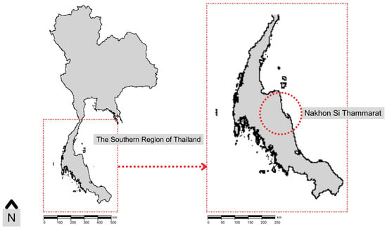
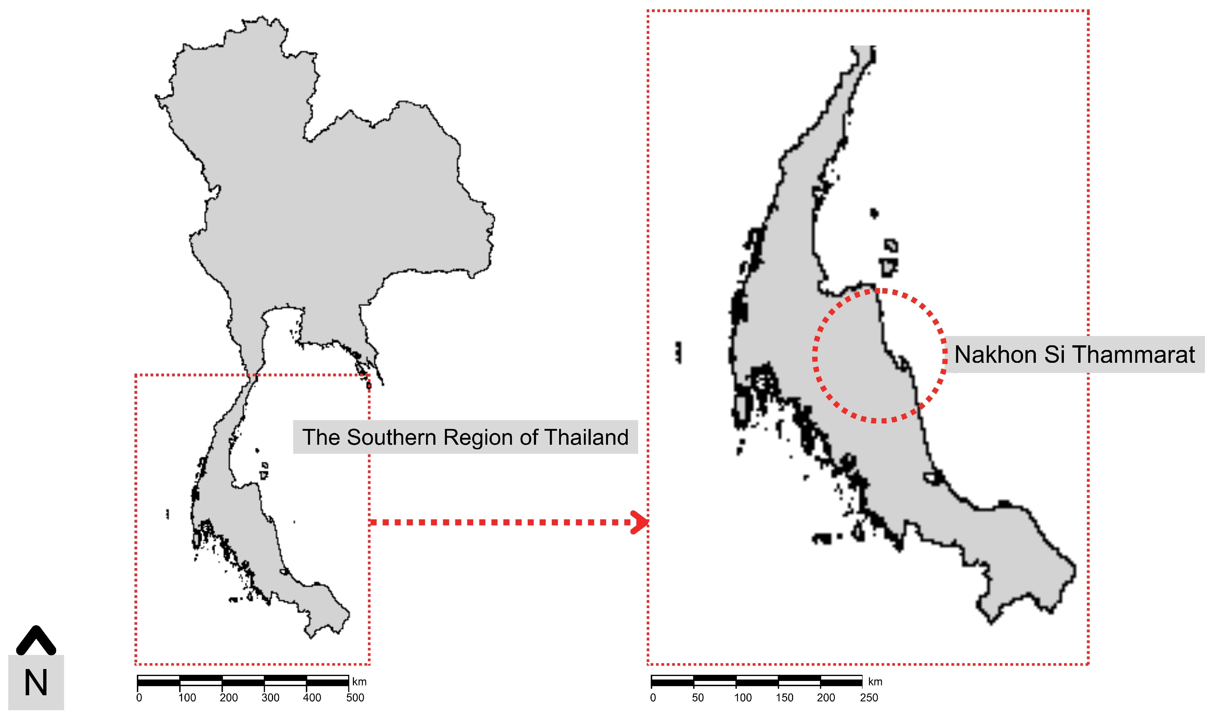
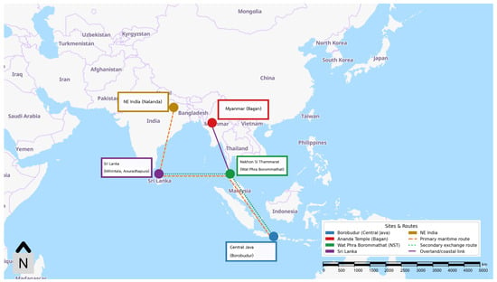
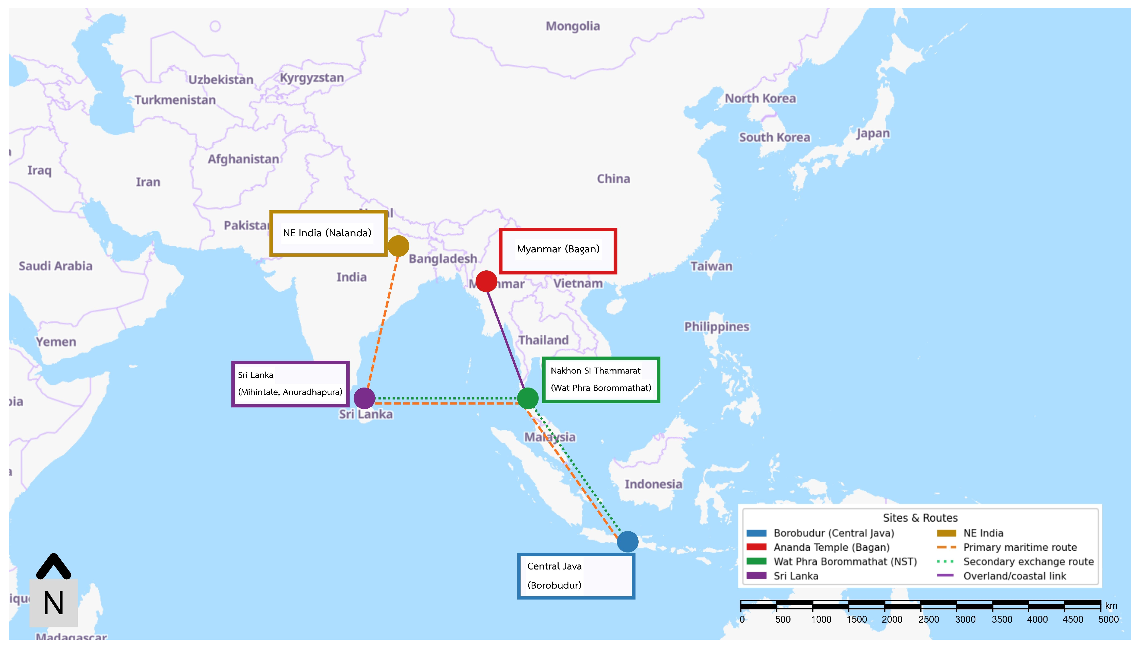
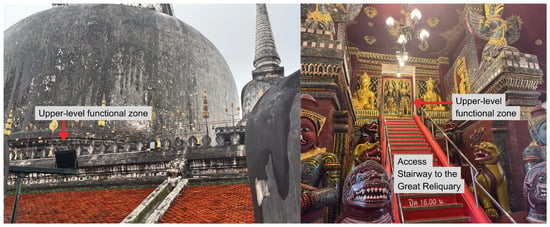
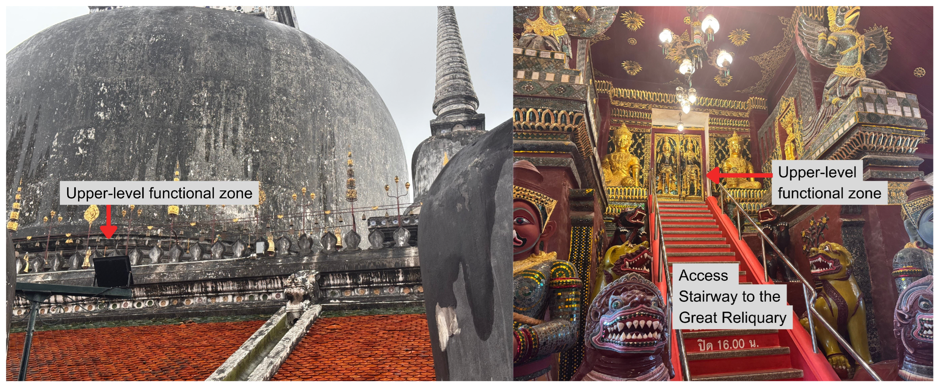
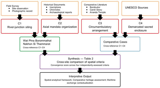
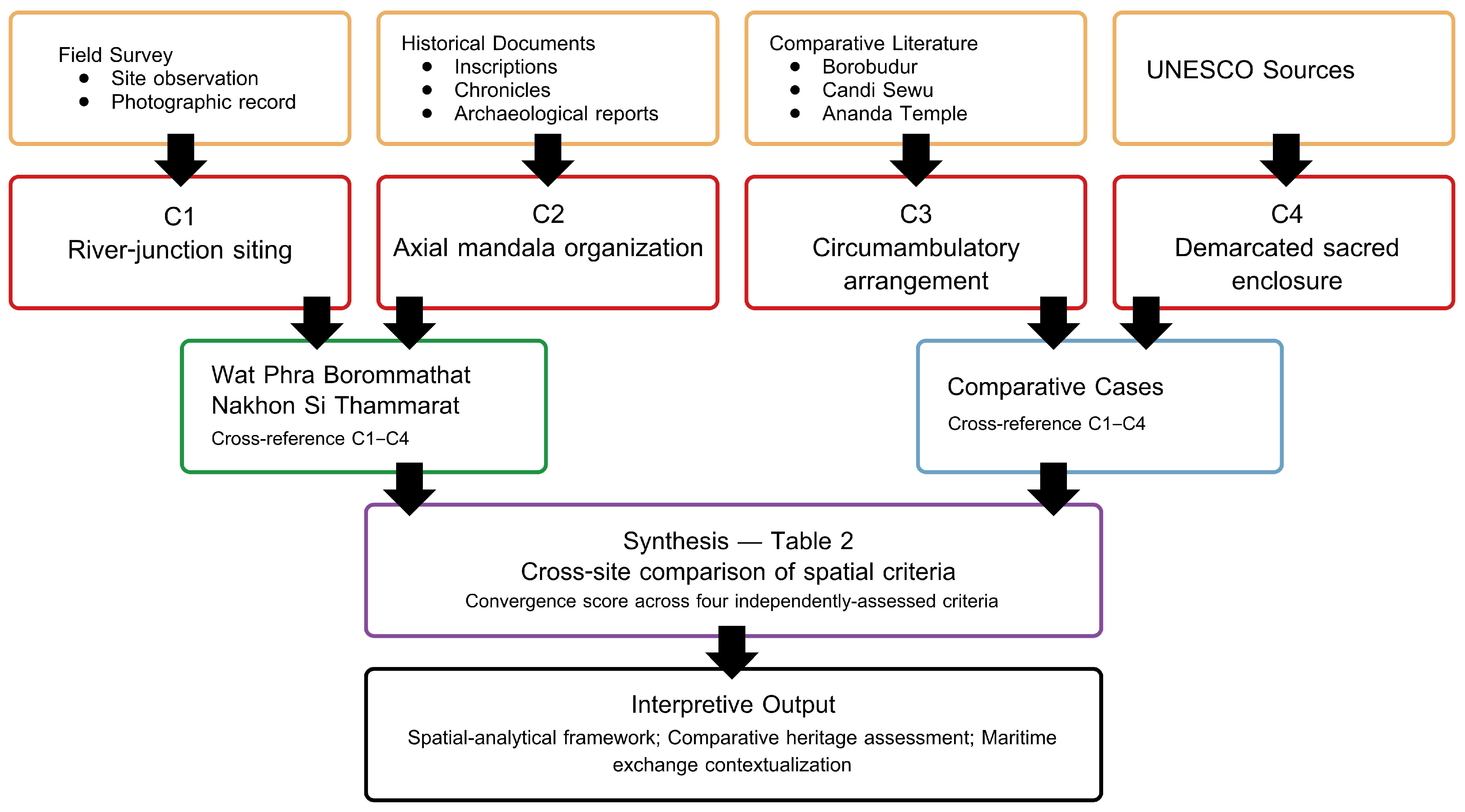
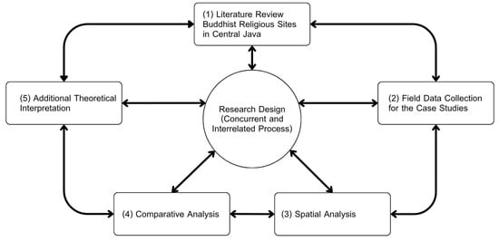
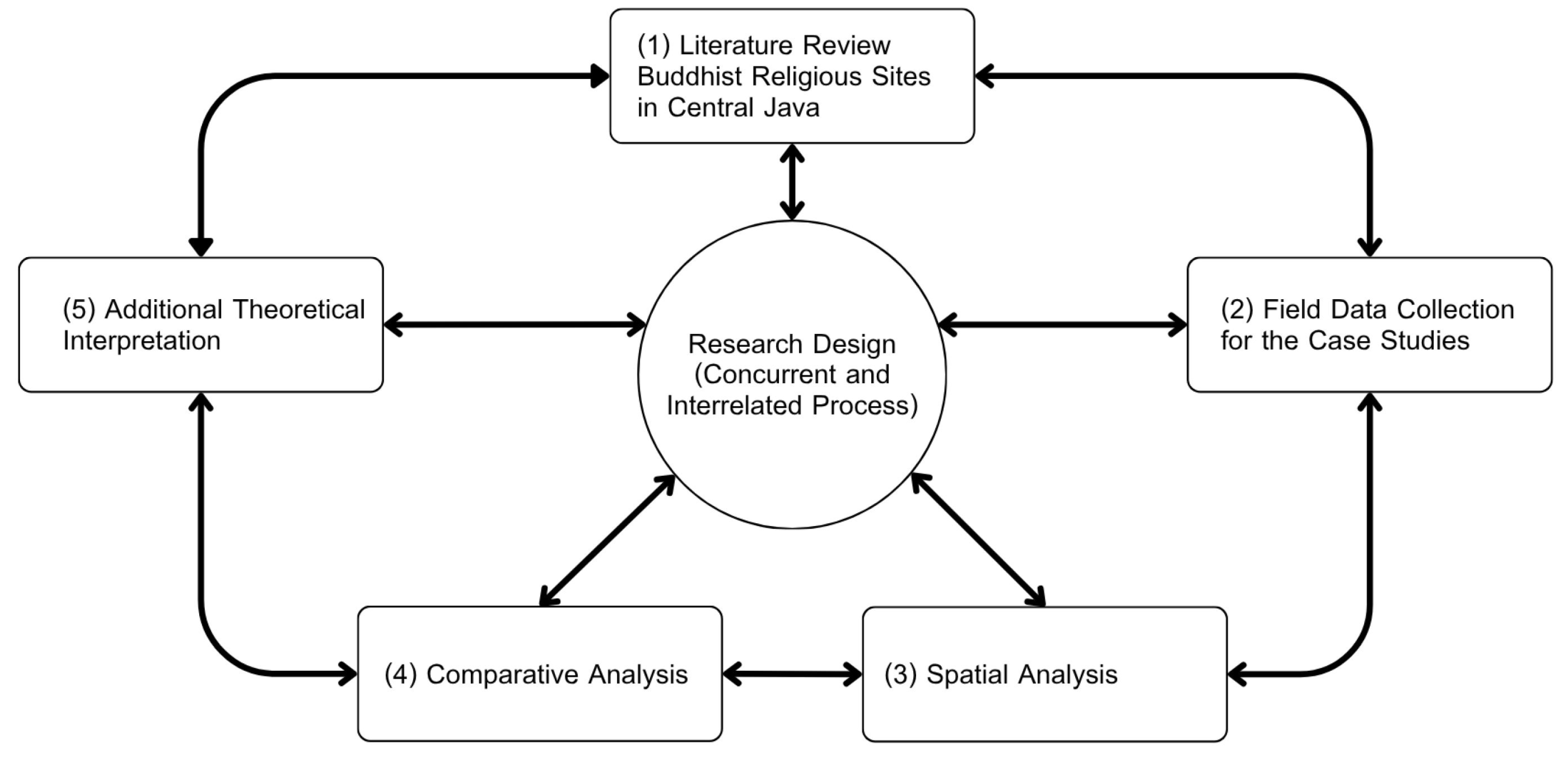
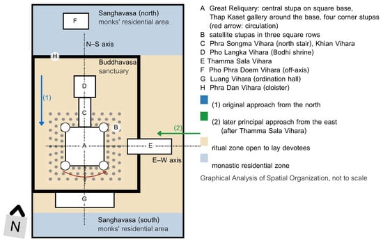
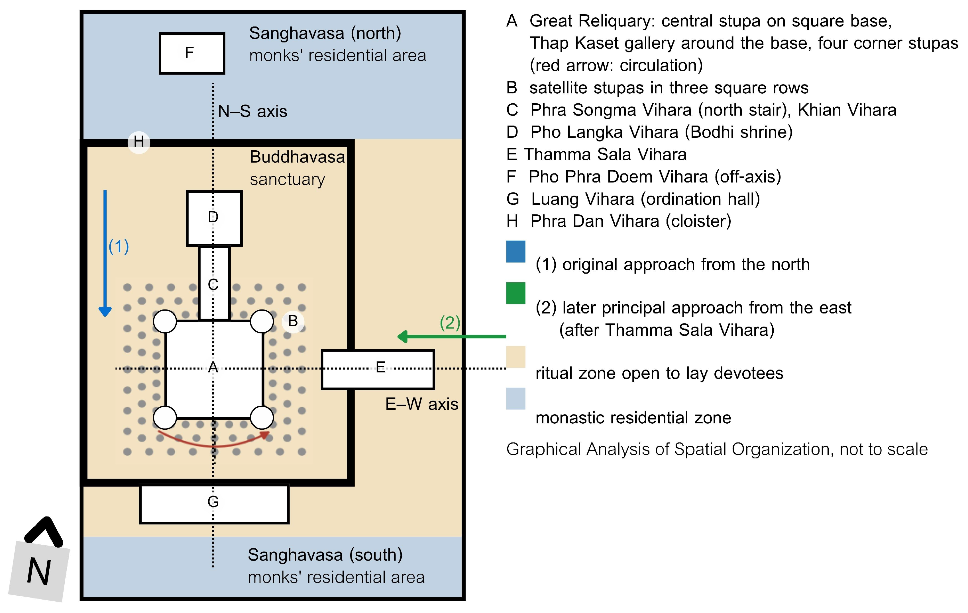
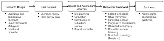
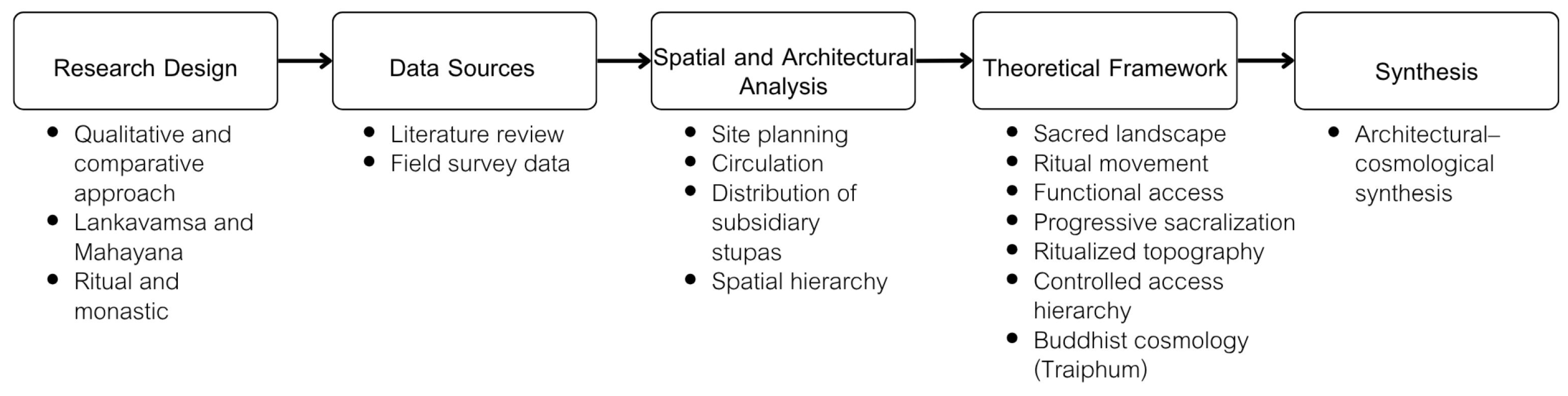
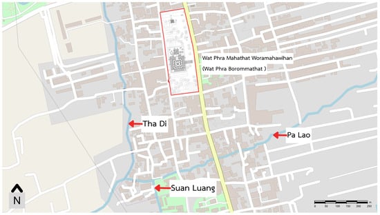
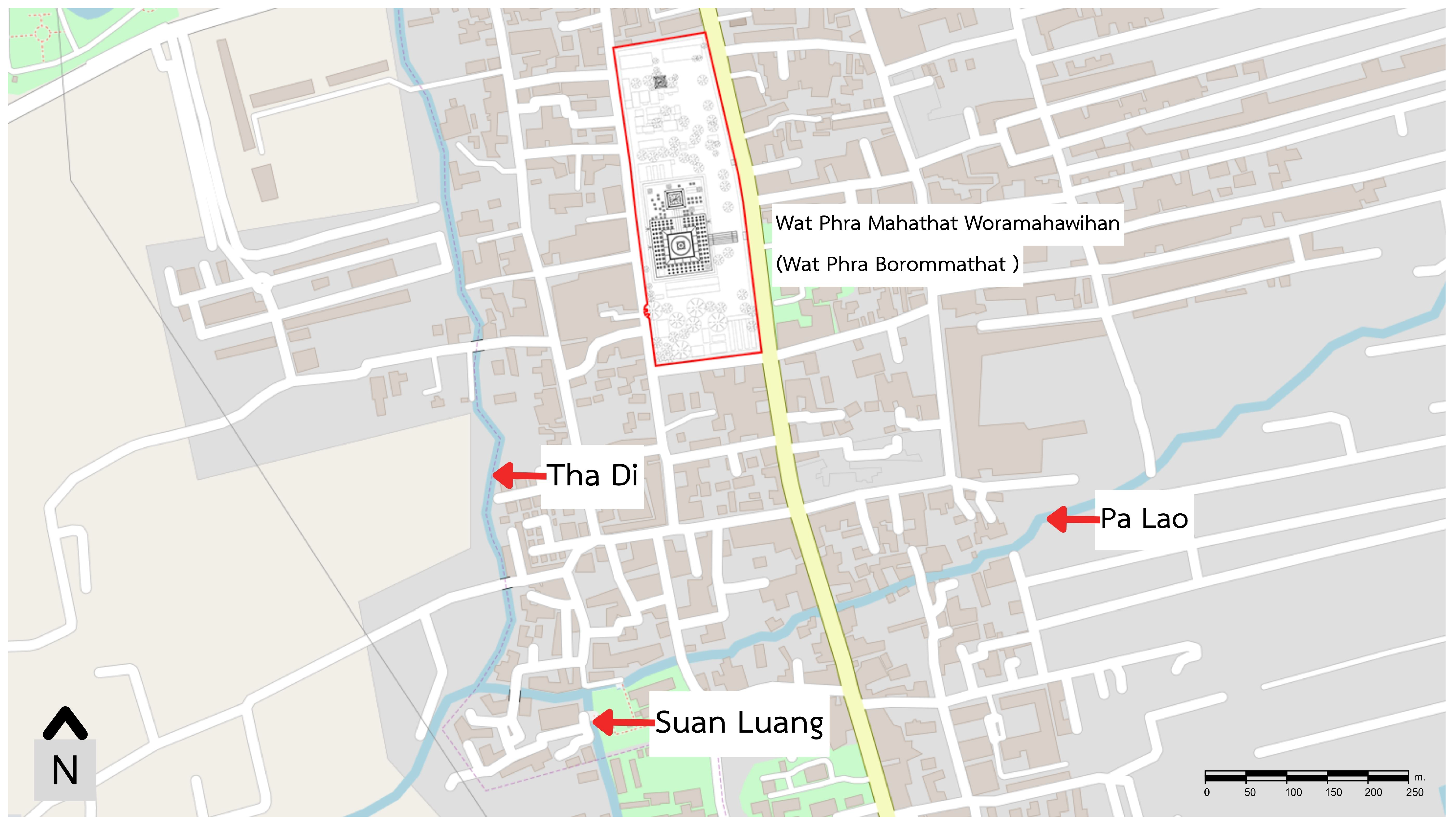
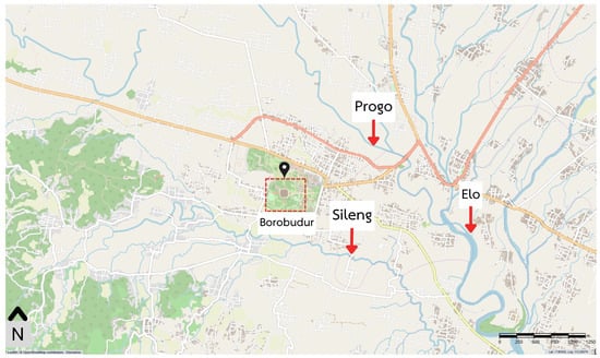
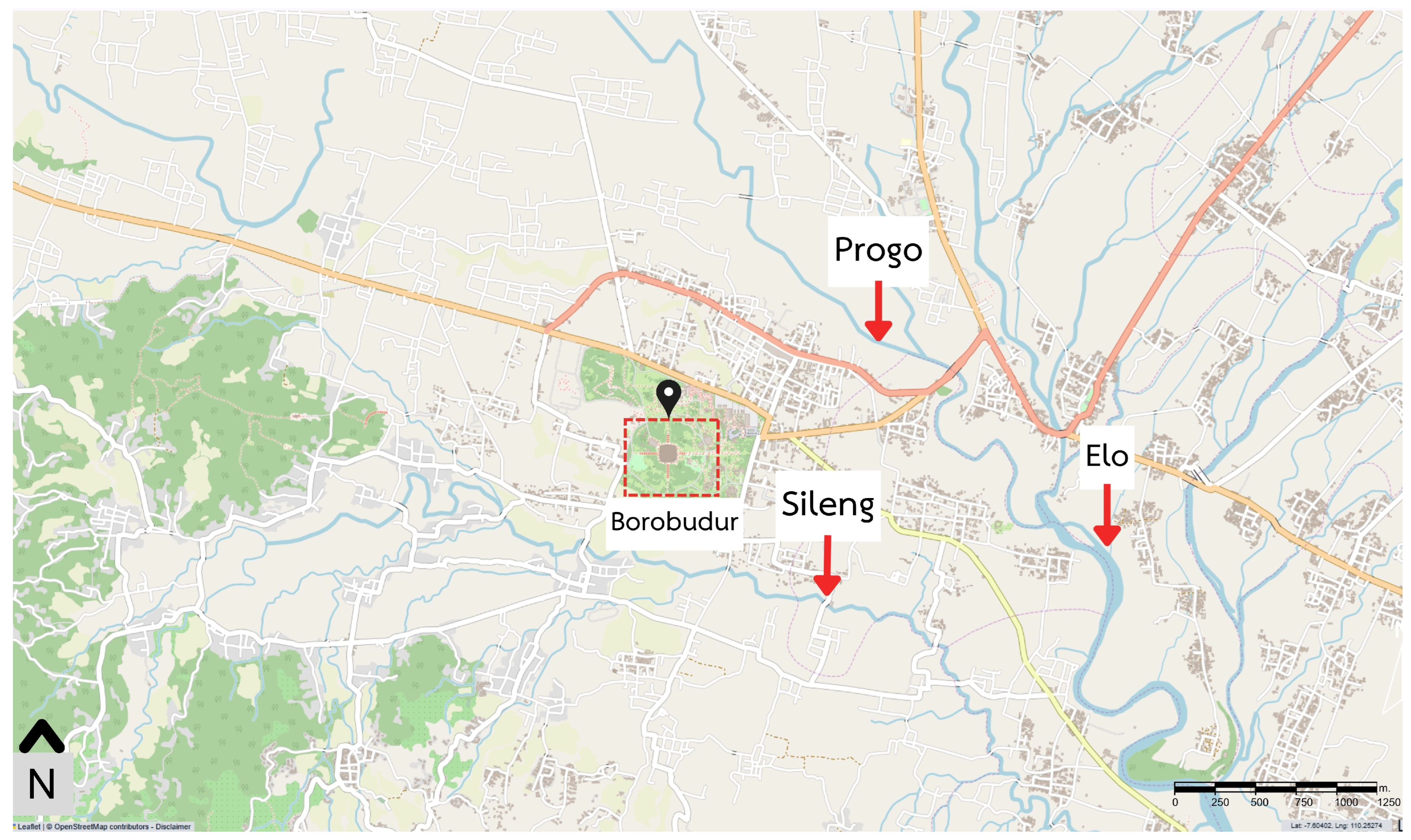
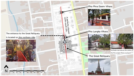
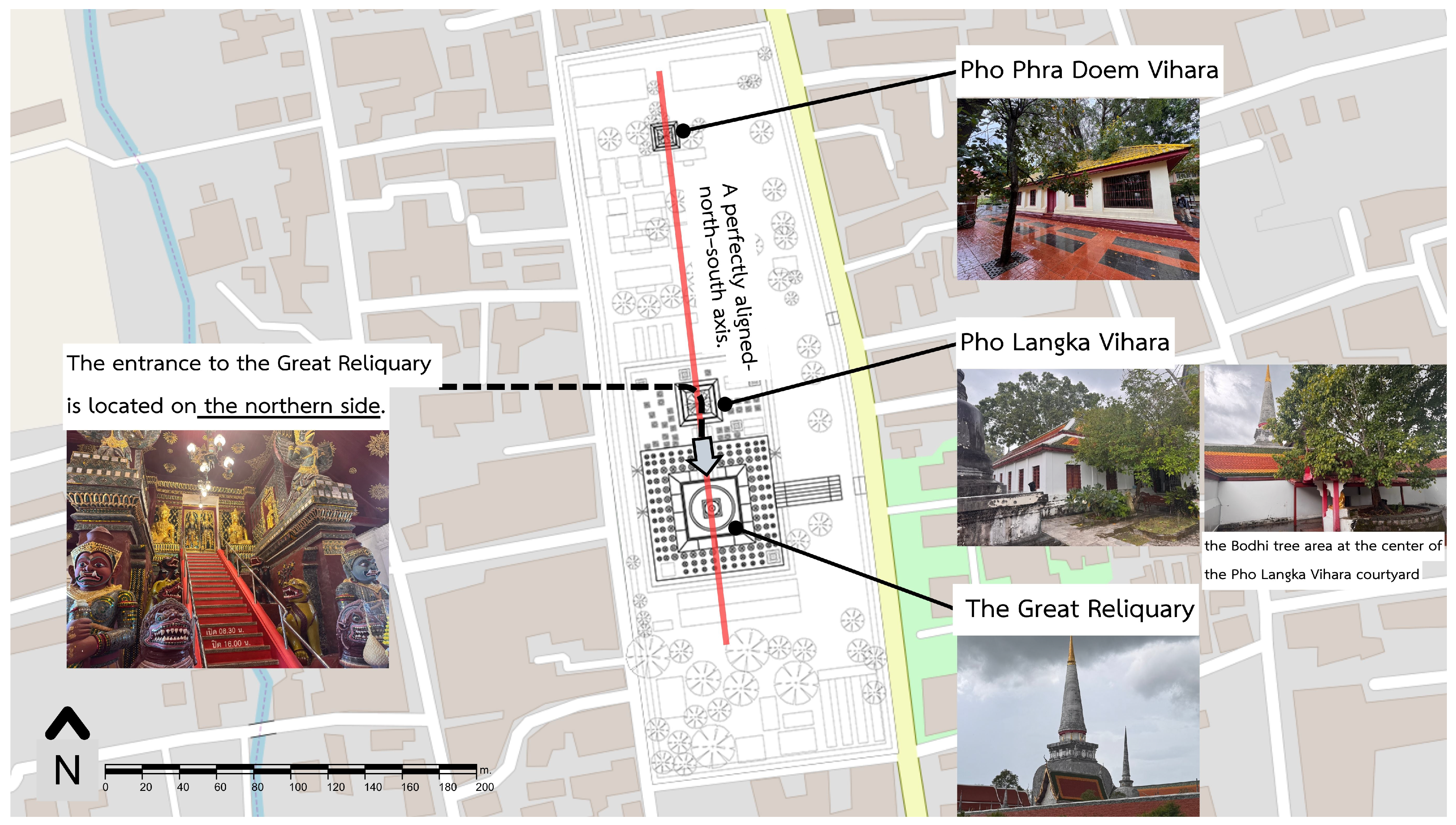
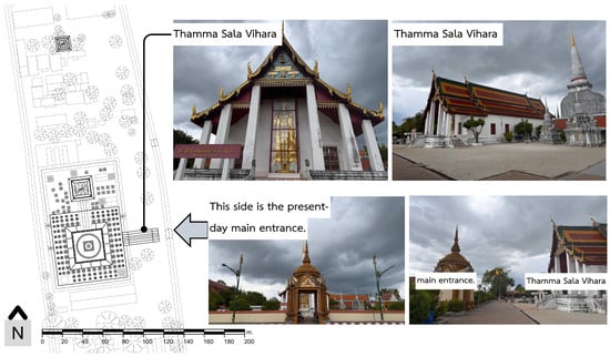
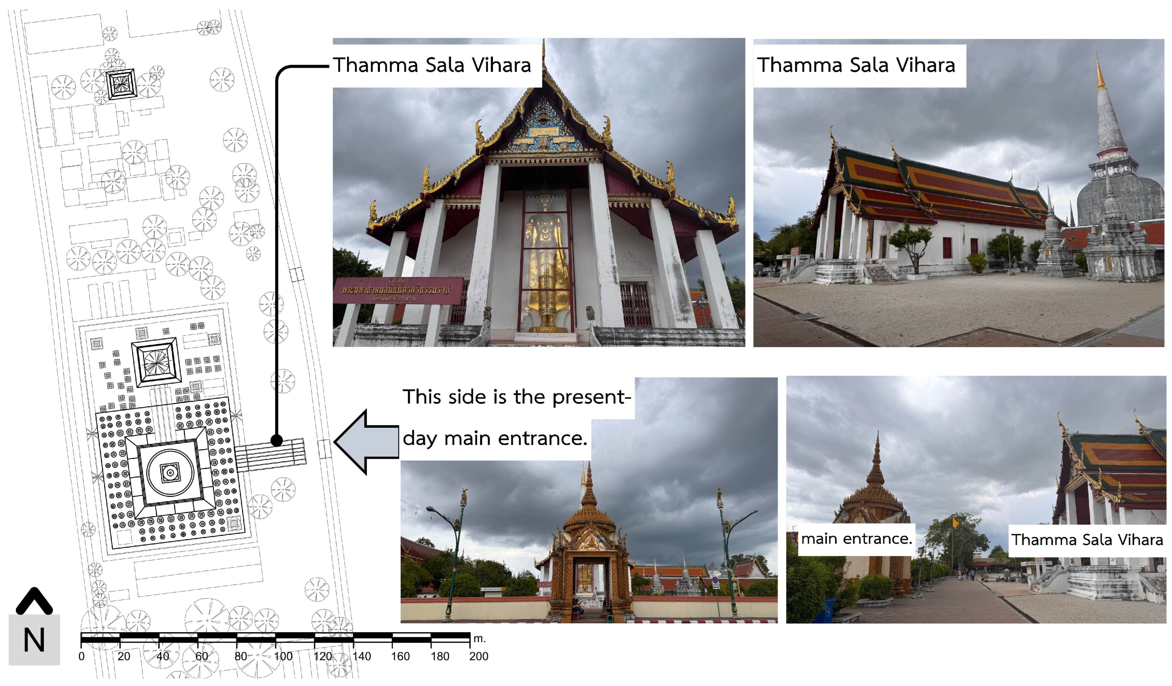
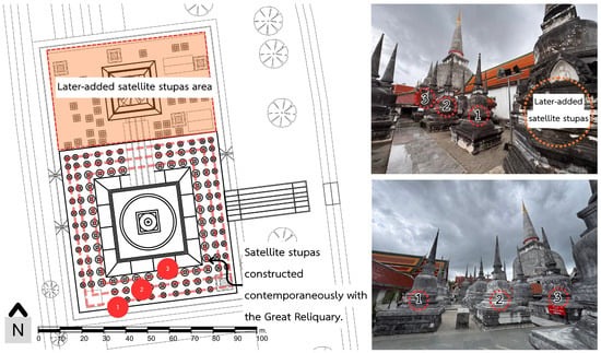
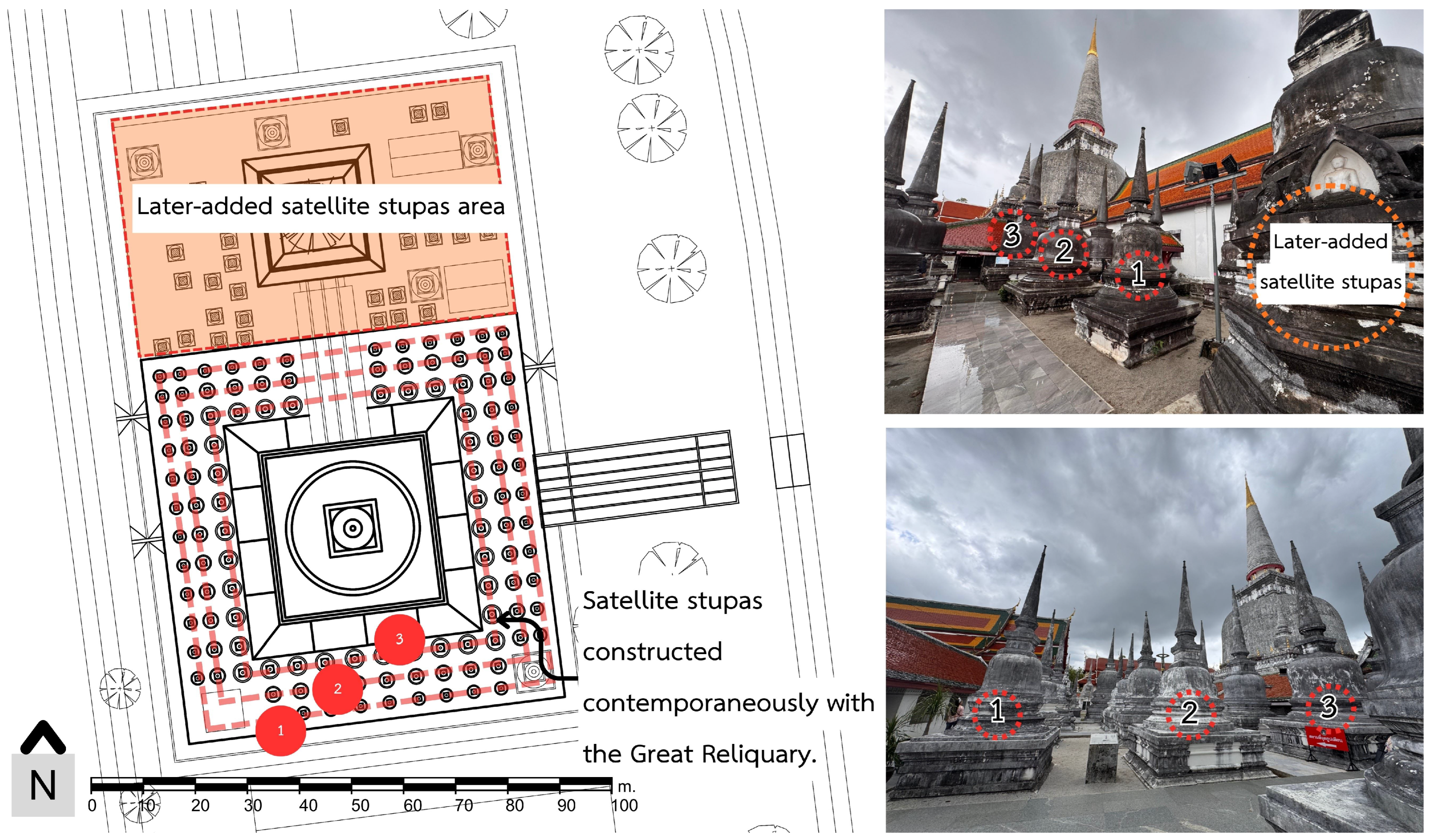
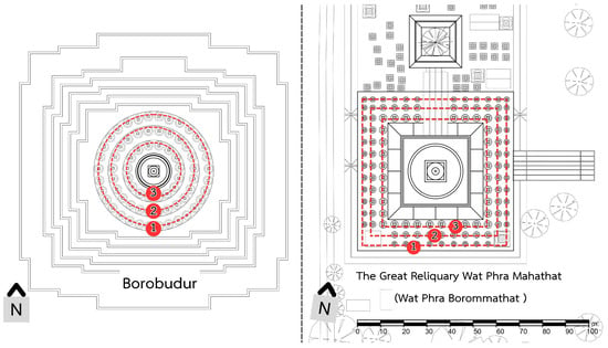
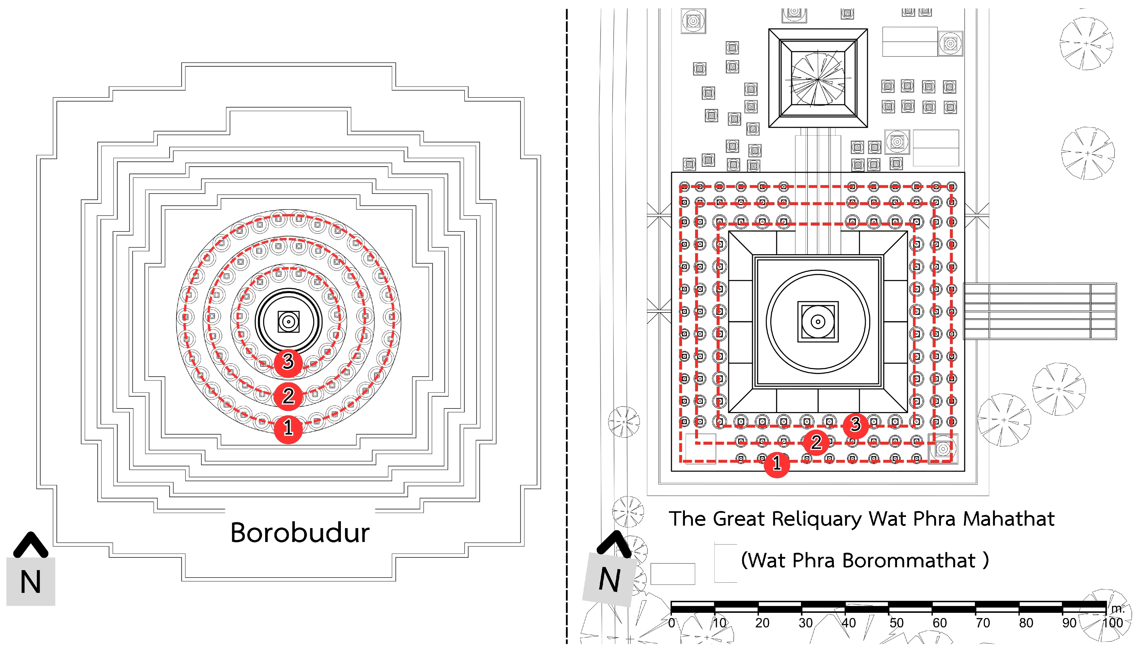
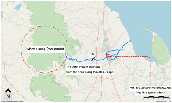
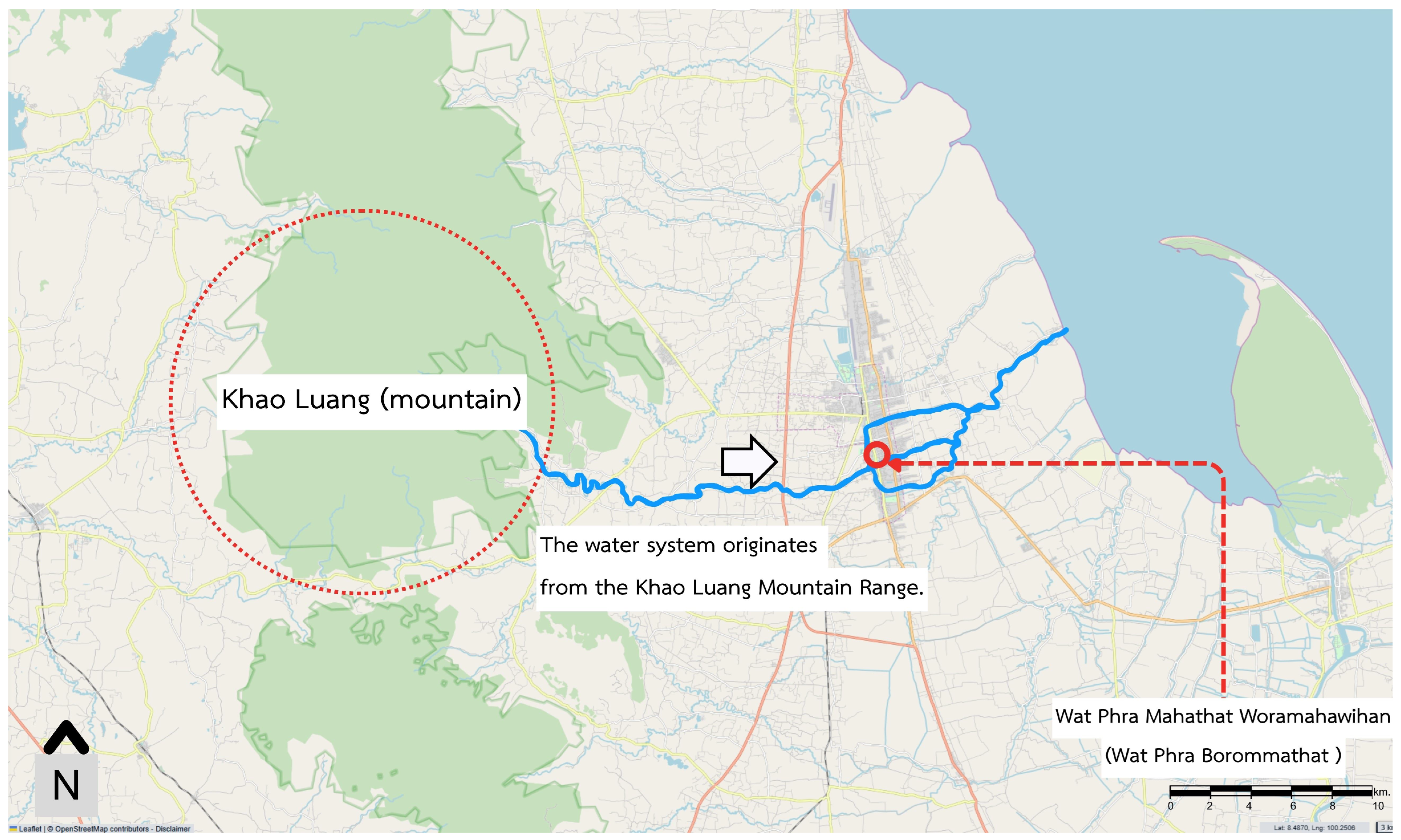
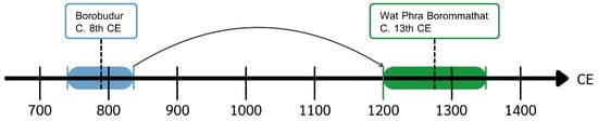
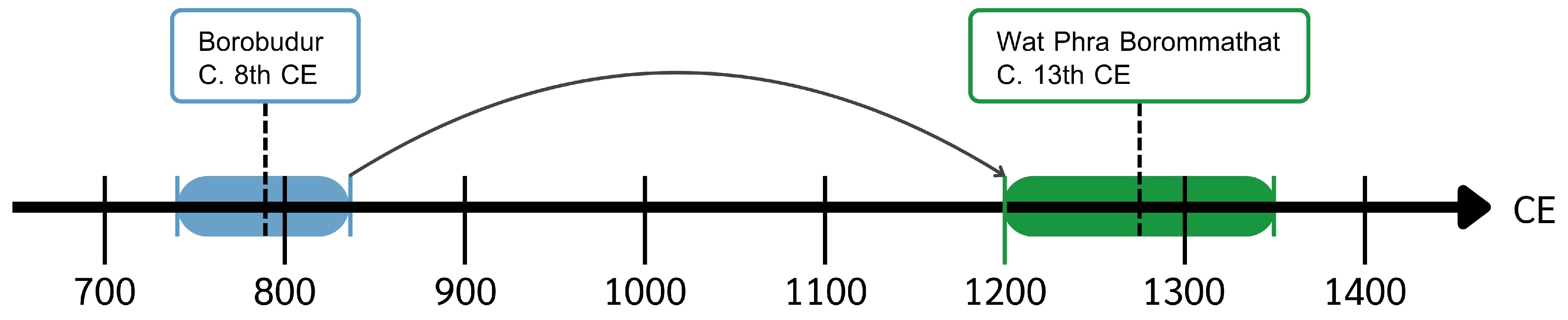
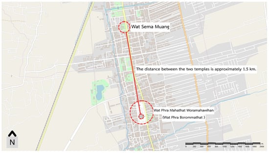
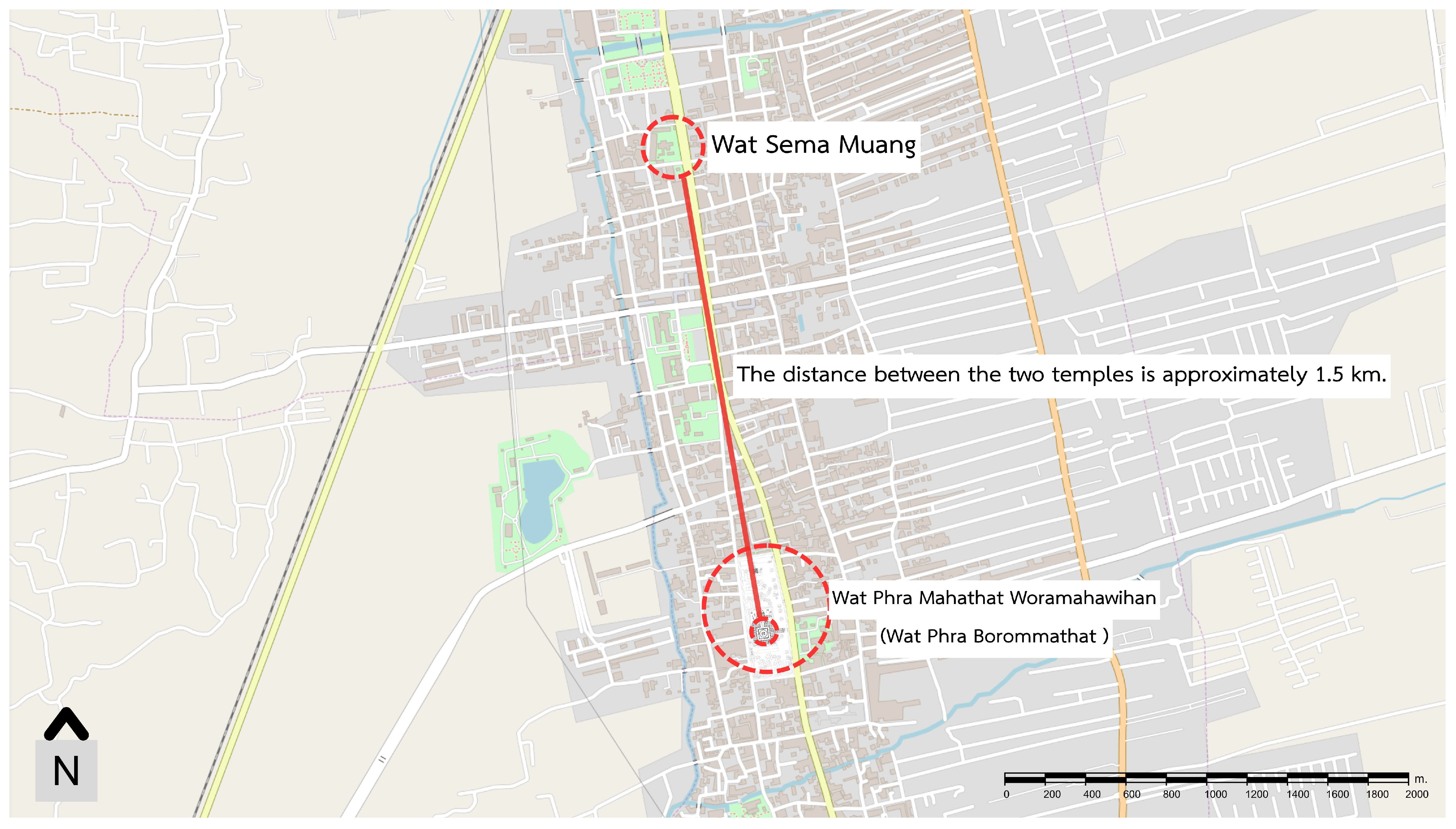
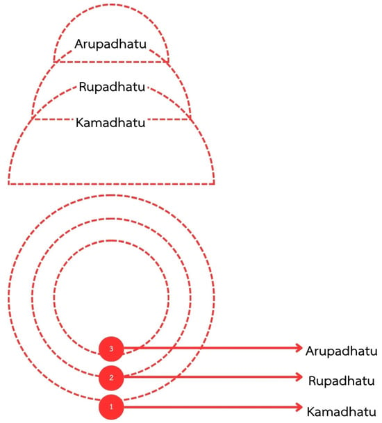
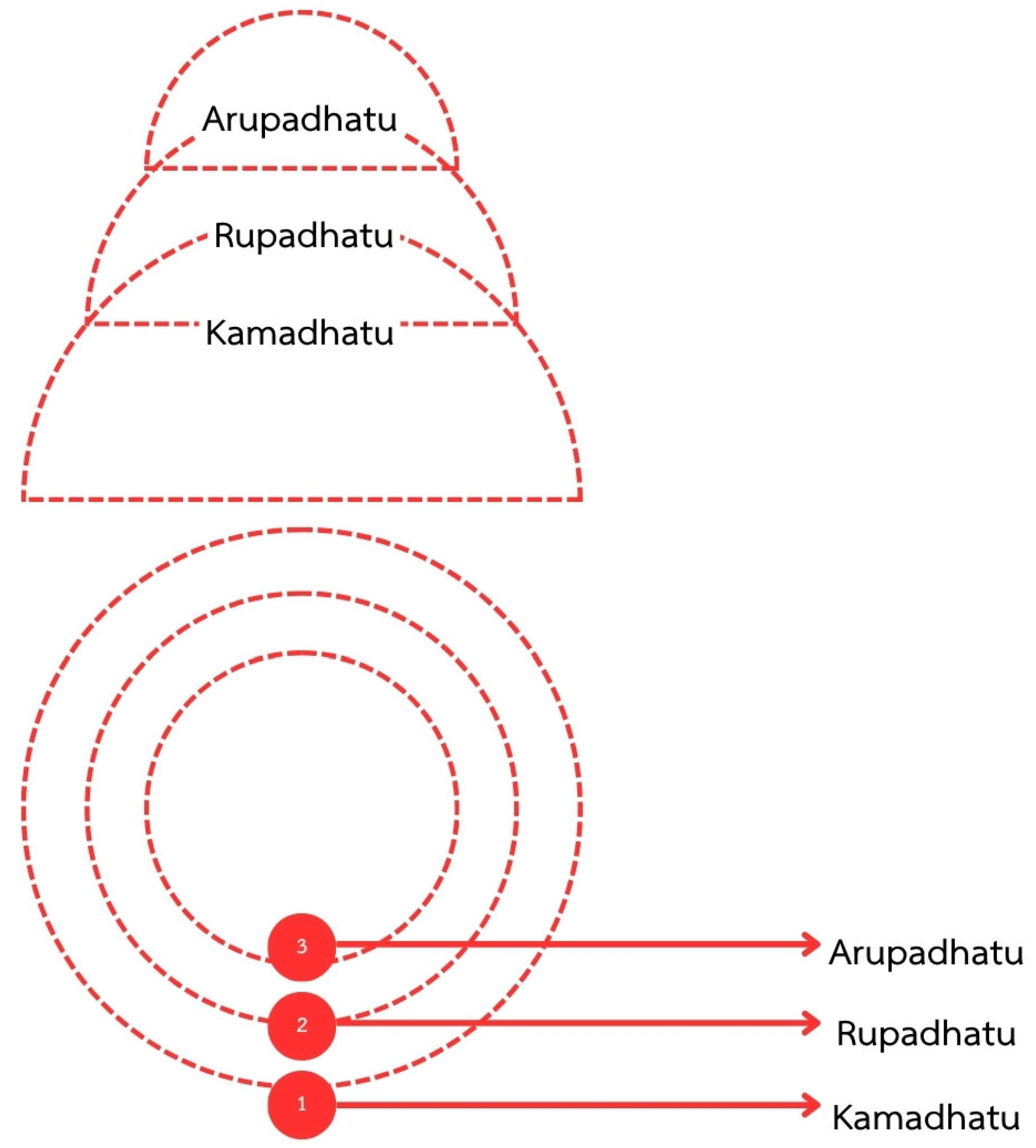
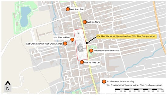
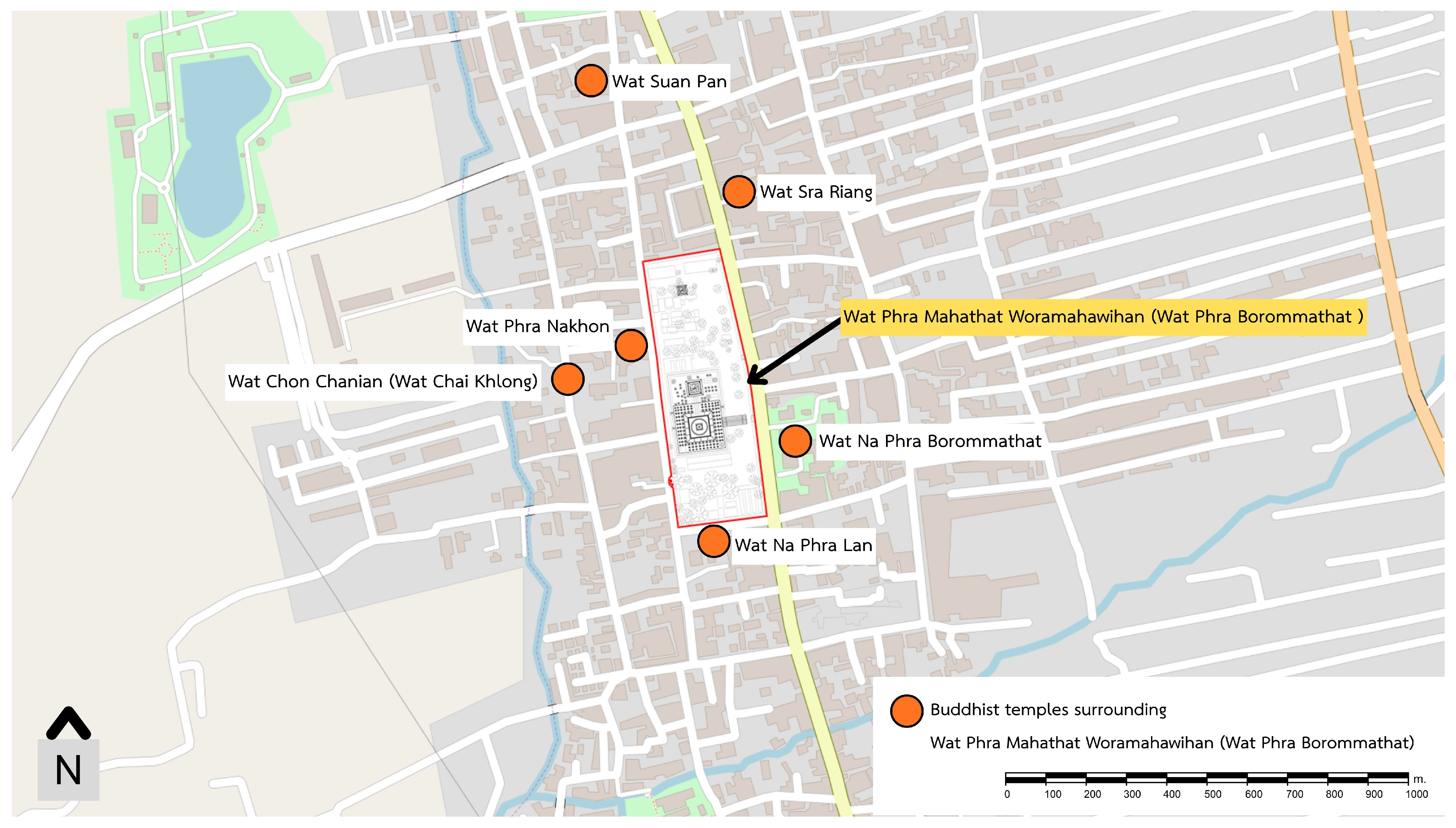
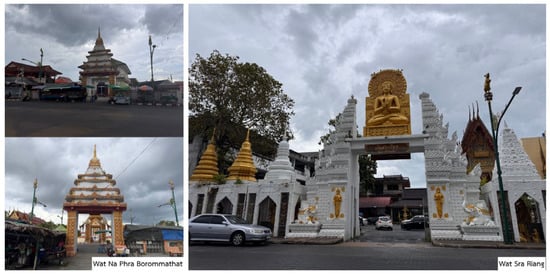
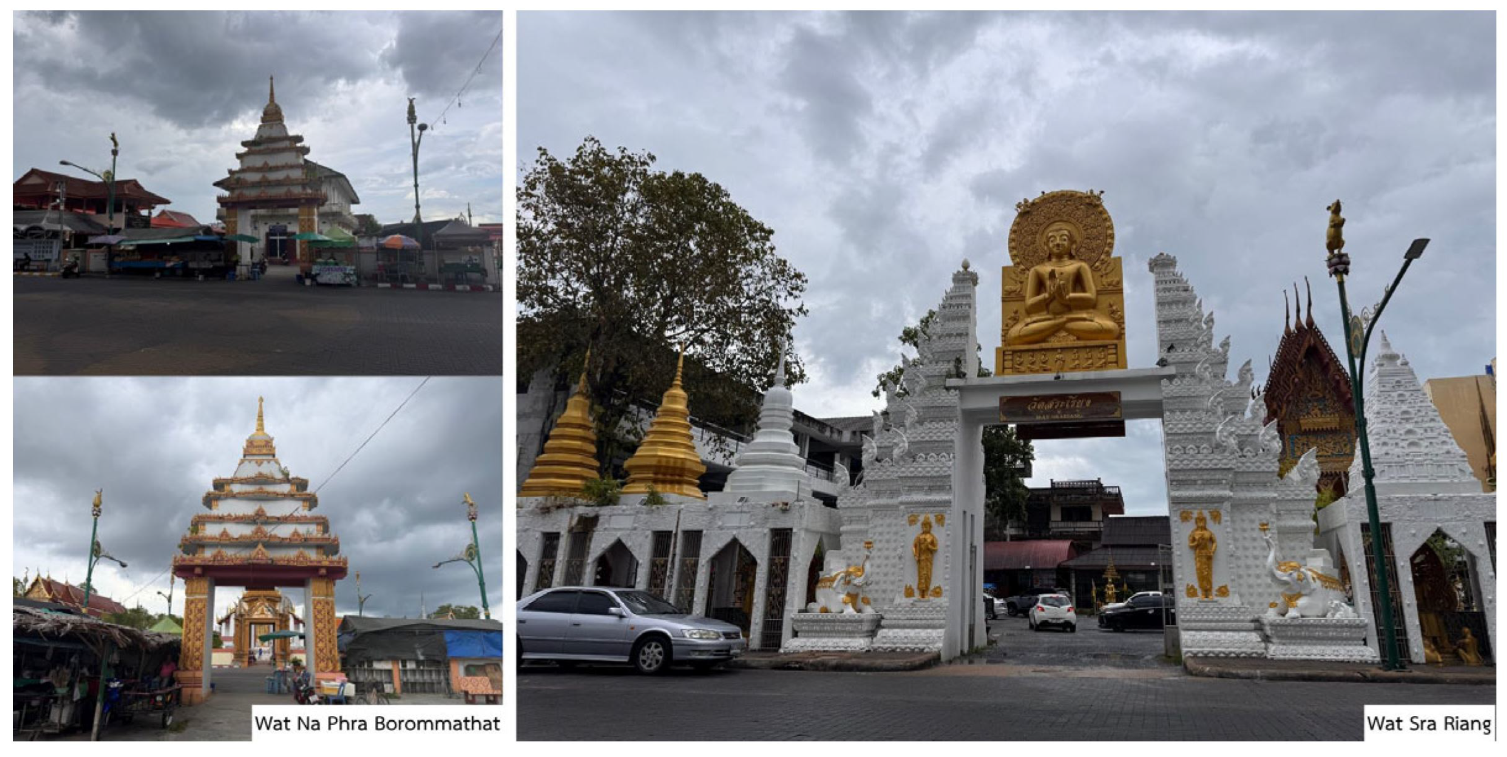

Disclaimer/Publisher’s Note: The statements, opinions and data contained in all publications are solely those of the individual author(s) and contributor(s) and not of MDPI and/or the editor(s). MDPI and/or the editor(s) disclaim responsibility for any injury to people or property resulting from any ideas, methods, instructions or products referred to in the content. |
© 2026 by the authors. Licensee MDPI, Basel, Switzerland. This article is an open access article distributed under the terms and conditions of the Creative Commons Attribution (CC BY) license.