Article

Resilience Mechanisms in Local Residential Landscapes: Spatial Distribution Patterns and Driving Factors of Ganlan Architectural Heritage in the Wuling Corridor

1
Visual Image Research Base of Chinese Nation, Southeast University, Nanjing 210096, China
2
School of Architecture, Southeast University, Nanjing 210096, China
*
Authors to whom correspondence should be addressed.
Heritage 2025, 8(11), 458; https://doi.org/10.3390/heritage8110458 (registering DOI)
Submission received: 5 October 2025 / Revised: 28 October 2025 / Accepted: 31 October 2025 / Published: 2 November 2025

Abstract

As a form of living cultural heritage, local residential landscapes manifest the essence of long-term, resilient human–land interactions. The Wuling Corridor, a vital ethnic and cultural passage connecting the Central Plains with Southwest China in Chinese history, serves as a crucial region for the mixed residence and cultural exchange of Tujia, Miao, Dong, Han, and other ethnic groups. Within this region, Ganlan stands as both the most representative vernacular architectural heritage and a residential form that is still extensively used, constituting a continuous and unique residential landscape. The spatial distribution patterns of Ganlan are the physical witness of the history of ethnic groups adapting to the complex topographic and cultural conditions. Current research focuses on the case description of single Ganlan forms, failing to systematically investigate the spatial formation mechanisms of Ganlan as a residential landscape from a geographical continuum perspective. Therefore, this study establishes a geographical database encompassing 9425 Ganlan samples from the Wuling Corridor. It integrates the geographic information system (GIS) with clustering algorithms to systematically identify the distribution patterns of Ganlan within specific geographic–cultural units and their coupling relationships with natural environments. It conducts quantitative analysis on the key driving factors concerning the emergence and evolution of Ganlan in the study area; the findings reveal the following: (1) Ganlan buildings exhibit a spatially aggregated distribution pattern along major water systems, demonstrating characteristics of multi-ethnic sharing and spatial interweaving. (2) Their distribution is constrained by natural geographical factors and influenced by the transmission pathways of construction techniques during ancient ethnic migrations to the southwest China. (3) Within multi-ethnic settlement structures, inter-ethnic cultural interactions (particularly with Central Plains culture) serve as a key driving force for the typological evolution of Ganlan. (4) The evolutionary lineage of “full-Ganlan,” “semi-Ganlan,” and “courtyard-style Ganlan” systematically demonstrates the dynamic adaptive capacity of local residential systems. Additionally, by integrating massive Ganlan heritage data with multiple spatial analysis methods, the study serves as a typical case study illuminating the adaptive strategies and resilience mechanisms of Ganlan as a local residential landscape formed in response to the environmental conditions and social changes. Also, it provides a scientific basis for the holistic conservation of architectural heritages shared by multiple ethnic groups and the integrated development of local cultural tourism industries.

1. Introduction

Ganlan, an architectural form with a long and rich history, originated from primitive “nest dwellings” and, together with “cave dwellings”, constitutes an important witness of early human civilizations [1]. Traces of Ganlan have been found in most regions associated with ancient human civilizations. Its defining feature—a raised living floor—exhibits remarkable adaptability to the climate of the Asian laurel forest zone, as well as the culture of rice cultivation and Xuju (seating lifestyles) [2]. Archaeological research suggests that the earliest instance of Ganlan was found at the Hemudu Site in China’s Yaojiang River Basin, dating back approximately 7000 years, demonstrating the middle and lower reaches of the Yangtze River and the areas south of it as key origins of Ganlan [3]. Since emerging in the Yaojiang River Basin, Ganlan has spread widely across East and Southeast Asia, giving rise to abundant vernacular variations [4]. They clustered in southern China, the Indo-China Peninsula, Southeast Asian countries, and spread to the Korean Peninsula and the Japanese Archipelago, forming the “Asian Crescent” cultural zone [5]. Throughout its prolonged history from emergence to dissemination and evolution, Ganlan has been subject to an unremitting, complex interplay of climate changes, ethnic migrations, and diverse local landforms. It encapsulates the ancient elements of human civilization and fully embodies the resilient mechanisms by which human dwelling systems dynamically adapt to complex natural and social conditions. Therefore, Ganlan is of significant research value in architecture, anthropology, and history.
It is noteworthy that Ganlan buildings are abundant and still widely used in China, regarded as the “living fossil” of vernacular architecture. In particular, the column and tie construction, the exemplary structure of Ganlan, represents one of China’s iconic traditional architectural forms. The Charter on the Built Vernacular Heritage, adopted in 1999 by the International Council on Monuments and Sites (ICOMOS), recognizes for the first time the unique value and importance of vernacular architecture as a cultural heritage and underlines its significance in cultural diversity, traditional techniques, and regional adaptability. Also, it stipulates authoritative guidelines for the protection of vernacular architecture worldwide [6]. Since then, a substantial number of Ganlan and villages in China have been listed in various levels of heritage protection systems for vernacular architecture, which in turn promotes in-depth explorations and systematic research on the heritage value of Ganlan in the academic community.
Regarding research on Ganlan buildings in the Wuling Corridor, scholars have primarily focused on two aspects: technology and culture. In terms of construction techniques, Ganlan specific to certain ethnic groups and areas have received considerable attention. Extensive documentation has been produced on the column-and-tie timber framing structures and mortise-tenon joint craftsmanship of the Miao ethnic group in western Hunan and the Tujia ethnic group in western Hubei [7,8], providing detailed data that deepens the understanding of Ganlan construction techniques in the Wuling Corridor. Building on this, existing research is apt to categorize Ganlan into different regional subtypes based on their structural systems, spatial organization, and other characteristics, with a focus on the correlations among column-and-tie construction, material selection, and structural stability [9], while also proposing research on craftsmanship genealogy in the Wuling region from the perspective of architectural history [10]. Regarding functionality and cultural symbolism, not only does Ganlan serve as a living space, but it also implies the social structure, religious beliefs, and familism [11]. From the space perspective, the ground floor is for livestock or farm tools, while the raised upper floors are for living, which indicates the wisdom of space utilization [12]. For ethnic groups such as Miao and Dong, the structural pattern, decoration, and orientation of Ganlan are often closely correlated with ancestor worship, worldview, and community identity [13,14]. In recent years, with enhanced awareness of urban-rural development and heritage protection [15], relevant research has gradually turned to the conservation, renewal, technique inheritance, and sustainable utilization of vernacular architecture, paying more attention to the preservation and cultural value reconfiguration of Ganlan in the context of modernization [16,17]. Meanwhile, the application of GIS technology has provided new perspectives for studying villages in this region. By establishing a geographic information database of traditional villages in the Wuling Mountain area, it revealed a clustered distribution pattern characterized by “high density in the central area and sparsity in the periphery” [18]. These studies identify the Youshui River basin as a core area for the concentrated distribution of Ganlan villages and highlight the spatial adaptability of Ganlan buildings, which typically “nestles against mountains and aligns with waterways” [19].
However, despite an overall tendency towards interdisciplinarity, existing academic achievements remain largely subject to the static analysis of Ganlan within a small area or a single ethnic group. Thus, a holistic perspective integrating human–land relationships, cultural interactions, and technique diffusion is required, thereby systematically revealing the complex dynamic interplay mechanisms between Ganlan’s spatial distribution, typological evolution, and their geographical environments, ethnic histories, and social structures—as an adaptive residential culture spanning multiple ethnic groups and regions.
Therefore, this research selects the Wuling Corridor in China as the study area. It regards all wooden Ganlan buildings within this area as an integral cultural geographical phenomenon to investigate their origins, dissemination, and evolution systematically. By constructing a Ganlan database encompassing multidimensional attribute information (e.g., Ganlan type, ethnicity, and geographical location), the research employs the geographic information system (GIS) and clustering algorithms for multivariate statistics and visual representation for the spatial distribution of Ganlan, thereby quantifying its spatial diffusion pathways and constructing dynamic models. Through spatial overlay and cumulative analysis of all attribute characteristics concerning Ganlan, the research identifies their distribution patterns and evolutionary trajectories in the process of cross-ethnic dissemination. Building upon this foundation, it further analyzes the natural and cultural factors driving the emergence of Ganlan in the Wuling Corridor and ultimately reveals the inherent resilience mechanisms governing the spatial distribution and typological evolution of Ganlan as a residential landscape adapted to diverse climatic and geographical scenarios and shared by multiple ethnic groups. Moreover, the study expatiates the symbiosis of Wulin Ganlan’s geographical distribution and the fact that it serves as both a residential system shared by multiple ethnic groups and local residential landscapes.

2. Study Area

The Wuling Corridor is located in the central hinterland of China, at the junction of four provincial-level administrative regions: Guizhou Province, Hunan Province, Chongqing Municipality, and Hubei Province. Centered on the Wuling Mountains, it constitutes a vital “geo-cultural” corridor (Figure 1). This region (28°~30° N, 107°~111° E) has a typical karst topography, characterized by undulating mountains and crisscrossing river valleys. The terrain is high in the west and low in the east, with an average elevation of approximately 1100 m (Figure 2).
As the transitional, folded zone from China’s second ladder to its third ladder, the Wuling Corridor is, above all, a typical geographical corridor, functioning as both a “passage” and a “barrier”. Following the courses of 6 major river systems (i.e., the Qingjiang River, Wujiang River, Yuanshui River, Youshui River, Lishui River, and Zishui River) and the Wuling Mountains, it has served as a vital passage connecting the Central Plains with Southwest China throughout Chinese history.
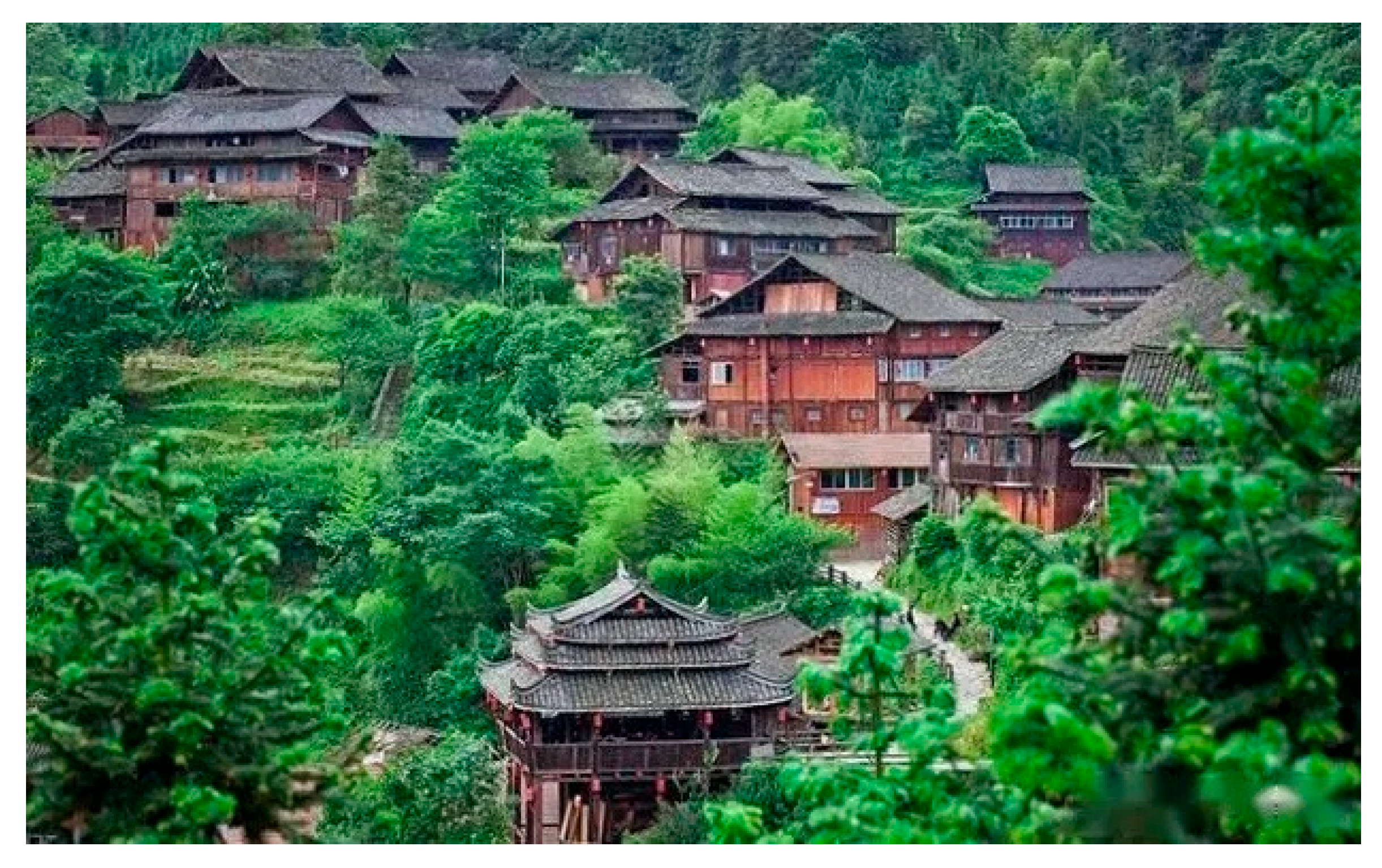
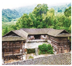
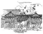
Meanwhile, the Wuling Corridor is an “ethnic corridor” and “cultural sedimentation zone” [20]. It is situated at the convergence of four major cultural spheres (i.e., the Central Plains Han Culture, Southwestern Di-Qiang Culture, Southern Baiyue Culture, and Central-Southern Baipu Culture). It was once a critical passage for the migration, interaction, and fusion of ancient Ba, Pu, and Chu peoples and later Miao, Tujia, Dong, and Yao peoples. This convergence fostered a cultural pattern characterized by the coexistence of multiple ethnicities, with the Tujia and Miao forming its core [21]. This unique cultural context has cultivated rich and diverse cultural heritages in the Wuling Corridor, which is especially evident in the abundant, still-in-use Ganlan-style buildings (e.g., stilted buildings). These buildings, either alongside mountains or rivers, in different forms, are extensively distributed in the Wuling Corridor, constituting a distinctive local residential landscape (Figure 3). They are important physical subjects for studying regional cultural resilience.

3. Data

3.1. Data Source

In this study, the geographical data consist of basic building data, natural resource data, and socio-cultural environment data [22]. Specifically, basic building data include geospatial location, administrative division, and ethnic group. Natural resource data include elevation, slope, mountain, river, and land use. Socio-cultural environment data include ethnicity, population, economy, policy, and key historical events.
To date, the large number and wide distribution of Ganlan have complicated the comprehensive and systematic collection and organization of relevant materials and data. This predicament has long impeded the cultural and geographical research of Ganlan from an overall spatial perspective [23]. Furthermore, owing to the inherent perishability and flammability of wooden structures, it is impossible to trace their evolutionary trajectory over millennia based solely on construction dates (existing Ganlan in the Wuling Corridor were mostly built in the Ming and Qing Dynasties). Instead, it should rely on quantification and typological feature extraction.
For the above reasons, our research team has been collecting data since October 2020 by virtue of geographical information retrieval (GIR), online image retrieval, literature retrieval, and field surveying. The geographical information data were primarily obtained through POI interfaces of mainstream LBS platforms, using a multi-level keyword combination strategy to ensure comprehensive sample coverage. The retrieval keywords encompassed three categories: building types (e.g., “Ganlan,” “Stilt house”), functional attributes (e.g., “traditional village”), and regional-ethnic identifiers (e.g., “Qiangdongnan Dong building”). Valid data of 9425 Ganlan in the Wuling Corridor were collected, involving four provincial-level administrative divisions, 79 counties, and 818 villages. Positional accuracy was determined according to the geometric center coordinates of the smallest administrative unit (i.e., town, township, and village), with 20.8% of the data manually verified through field surveys. Additionally, the research team performed meticulous architectural surveying and mapping, image collection, and information recording for Ganlan in 235 typical villages. In-depth interviews were held with 97 key informants, including craftsmen, inheritors of Chinese traditional architectural craftsmanship for timber-framed structures as an intangible cultural heritage, and residents, to gather insights into the typological characteristics and evolutionary trajectory of various Ganlan forms within the Wuling Corridor. Additional building data were obtained from literature reviews and image archives. The data sources include the following:
1.
The historical geographic information data
The China Historical GIS (https://chgis.fas.harvard.edu, accessed from 8 October 2021 to 30 May 2025), Chinese Historical Geography Digital Application Platform (https://timespace-china.fudan.edu.cn/FDCHGIS/homePage, accessed from 21 May 2022 to 30 May 2025). Ministry of Housing and Urban-Rural Development of the People’s Republic of China (https://www.mohurd.gov.cn, accessed on 25 April 2025).
2.
Local Chronicles
These historical materials provide temporally continuous information on geographical changes across dynasties. This study retrieved 178 local chronicles related to the Wuling Corridor, including general chronicles, special chronicles of ethnic autonomous prefectures, traditional village records, and cultural heritage protection annals, from the History Book about Nan Zhao in the Tang Dynasty that first described “nest dwellings” to the latest documents.
3.
Maps and Geographical Data
In this study, all geoprocessing operations were performed on the GCS_WGS_1984 Coordinate System. All maps, as well as administrative boundaries and national borders, were drawn based on the maps provided by the Ministry of Natural Resources of the People’s Republic of China (https://www.mnr.gov.cn/, accessed on 10 April 2025). Geographical elevation data were sourced from the open database of NASA SRTM DEM, with a 90 m resolution, and processed by the Geospatial Data Cloud, Computer Network Information Center, Chinese Academy of Sciences (http://www.gscloud.cn/, accessed on 25 April 2025). Other basic geographical data on climate, terrain, vegetation, water, and transportation were from the National Geomatics Database (2018 version) and the National Natural Resources and Geospatial Basic Information Database (https://www.sgic.net.cn/portal/index.html#/Home, accessed on 22 April 2025).

3.2. Data Preprocessing and Classification Coding of Geographic Information

The research team first integrated information coding with visual interpretation [24] to standardize all Ganlan data. Then, the team clipped and projected the terrain data and used the topographic position index (TPI) to identify the spatial distribution characteristics of Ganlan. At last, this study employed a Convolutional Neural Network (CNN) based on the VGG16 architecture to convert all image data into feature vectors for feature extraction. The key hyperparameters were set as follows: the Adam optimizer was used with an initial learning rate of 0.0001; the batch size was set to 32; training was conducted for 100 epochs, incorporating an early stopping mechanism that halted training if the validation loss did not decrease for 10 consecutive epochs to prevent overfitting; the categorical cross-entropy loss function was adopted. Through this process, three key feature indices of Ganlan—“Architectural Feature”, “Ethnic Feature”, and “Position Feature”—were identified, corresponding to “Physical Attribute”, “Social Attribute”, and “Spatial Attribute”, respectively. Thus, this study designed a classification coding hierarchy consisting of 5 code segments and 33 code bits:
1.
Building Code (BA)
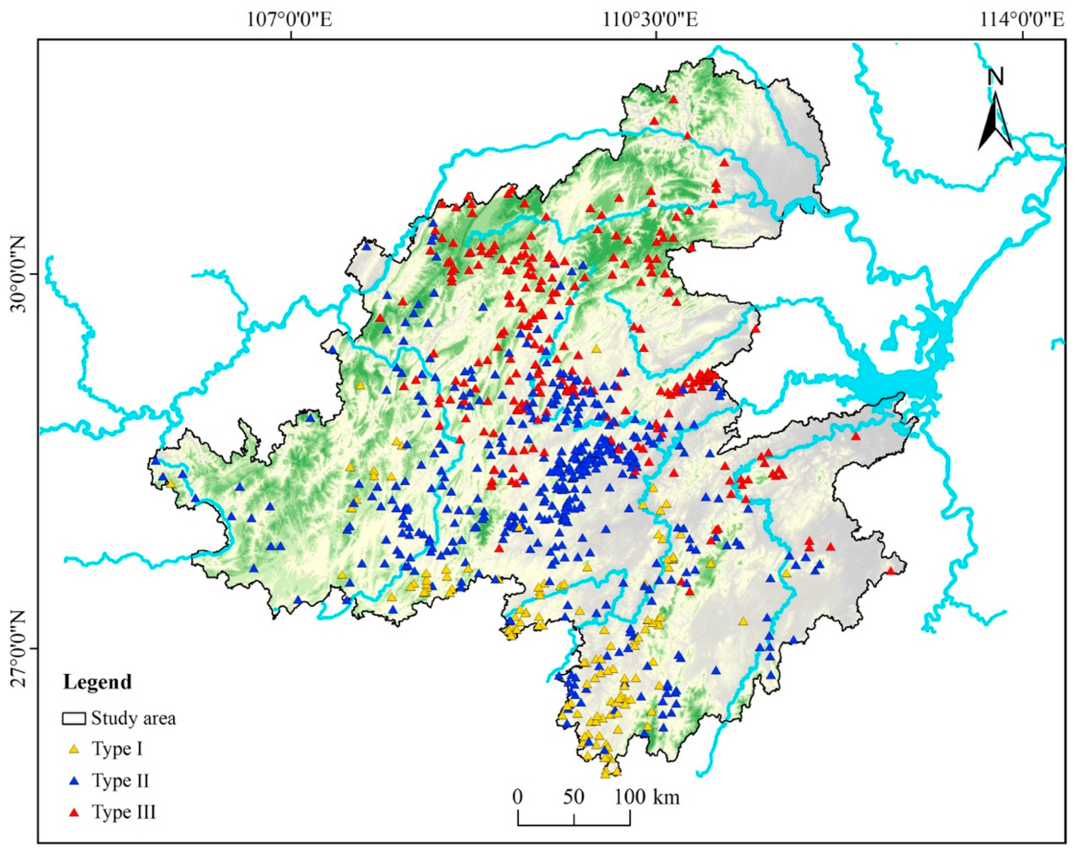
It includes three topographic attribute labels (BA-T) (i.e., mountain-dwelling, water-dwelling, and flatland-dwelling), eight spatial attribute labels (BA-S) (i.e., spatial form, elevated height, architectural morphology, plane layout, openness, percentage of raised-floor area, entry mode, and number of bays), and eight construction attribute labels (BA-C) (i.e., structural form, number of stories, column feet height, joint construction, building materials, number of fire pits, roof pitch, and interior wall height). On the basis of these nineteen characteristic attributes, three Ganlan types (Type I~III) were defined via cluster analysis (Section 4: Methods), as shown in Figure 4 and Table 1.
2.
Ethnicity Code (E)
It indicates to which ethnic group the Ganlan belong. A total of 10 ethnic groups are involved in the research, including Miao, Tujia, Dong, and Han.
3.
Location Code (L)
It indicates to which administrative village, town (or township), city (or county), district (or autonomous prefecture), and province (or autonomous region or municipality) the Ganlan belong.
4.
Coordinate Code (C)
It indicates the longitude, latitude, elevation, and slope of the area where the Ganlan are located.
5.
Climate Code (CZ)
It indicates the mean annual precipitation, mean annual humidity, and mean annual temperature of the area where the Ganlan buildings are located.

3.3. Establishing GIS Spatial Database of Ganlan

By inputting the preprocessed Ganlan point data and related geographical feature data into the Geodatabase data model, the study constructed a GIS spatial database of Ganlan for the Wuling Corridor. The 9425 Ganlan were treated as point features in the geographical space [25], and their thematic data, vector data, and raster data were all stored in a relational database [26]. According to the differences in data structure and geometry type, they were stored separately in different datasets (e.g., Feature Dataset, Raster Dataset, and TIN). Since architectural and ethnic attributes are non-spatial data, they were associated with the Ganlan thematic data via coding [27]. More specifically, text data were organized and stored in the Table Dataset as extended attribute items of the attribute table for Ganlan thematic data. Image data were stored in the Raster Dataset, associated with the Ganlan thematic data through predefined naming conventions [28]. Taking the image named “III-Tu-04-ES-L103-089-001” as an example, the “III-Tu” refers to a Type-III Ganlan owned by the Tujia people, the “04-ES-L103” is the code for Shiqiao Village, Sanhu Township, Laifeng County, Enshi Tujia and Miao Autonomous Prefecture, Hubei Province, and the “089-001” is the sequence number of the image data for Ganlan #89. In this way, the thematic data were associated with attribute data and image data via coding.

4. Methods

4.1. Cluster Analysis

Cluster analysis aims to excavate the intrinsic structures of data for natural grouping. Its core principle is to maximize within-cluster similarity and between-cluster differences to realize automatic grouping of samples with similar characteristics into clusters. This study adopted a partition-based clustering framework and utilized quantified feature distances to classify Ganlan buildings. The K-means algorithm was employed, along with the K-means++ initialization strategy to enhance clustering performance. This strategy disperses the initial cluster centers through a probabilistic distribution, effectively mitigating the risk of clustering quality degradation associated with traditional random initialization. The optimal number of clusters was determined based on the analysis results of the Elbow Method and Silhouette Coefficient, with K = 3 identified as the most suitable parameter. This classification not only satisfies statistical significance but also aligns with the staged characteristics of the evolutionary trajectory of Ganlan architectural forms. The objective function is formulated as follows:
J = k = 1 K   x C k   x μ k 2
where C k is the k th cluster, containing multiple samples, and μ k is the centroid of the k th cluster. x μ k 2 is the squared Euclidean distance between Sample x and Cluster Centroid μ k .
In essence, K-means clustering partitions samples into k types such that samples within each type are as similar as possible (in this case, the sum of squared distances from samples to their respective cluster centroids is the minimum). Based on the final clustering results, the research conducted geographical differentiation for the typological characteristics of Ganlan, thereby providing a quantitative basis for subsequent analysis of spatial distribution patterns.

4.2. Point Density Estimation

This study employed point density estimation (PDE) to fit the spatial distribution characteristics and identify hotspots of Ganlan in the Wuling Corridor [29]. Using the “Point Density” module in ArcGIS 10.8, it treated all Ganlan as vector points in the space to calculate the density of point features as the ratio of the number of all points within a neighborhood to the neighborhood’s area. Then, linear regression analysis was performed for the spatial variation function of point density to obtain the density distribution characteristics of Ganlan. The calculation equation is
F ( x ) = 1 n h i = 1 n   k d x x i h
where F(x) is the PDE value of Point x, n is the number of Ganlan of each type, k is the point function, d is the dimensionality, and (x − xi) represents the distance from Estimation Point x to Sample Point xi.
The closer a sample point is to the center, the higher the PDE value, indicating a more significant trend of concentrated Ganlan distribution.

4.3. Standard Deviation Ellipse Analysis

In geospatial analysis, the standard deviation ellipse (SDE) is one of the mainstream solutions for quantifying the central position, primary direction, and discrete range of spatial point distribution [30]. As the spatial distribution of Ganlan is uneven and inconsistent due to various influence factors (e.g., physical geography, history, and culture), the study utilized three key SDE parameters (i.e., mean center, rotation angle, and standard deviations of the major/minor axes) to, from a cultural geography perspective, quantitatively characterize the spatial distribution patterns of Ganlan with different attributes, as well as the evolutionary trajectory, orientation, and range of each type of Ganlan. The calculation is as follows:
t a n θ = i = 1 n   x ˜ i 2 i = 1 n   y ˜ i 2 + i = 1 n   x ˜ i 2 i = 1 n   y ˜ i 2 2 + 4 i = 1 n   x ˜ i y ˜ i 2 2 i = 1 n   x ˜ i y ˜ i
σ x = 2 i = 1 n   x ˜ i c o s θ y ˜ i s i n θ 2 n
σ y = 2 i = 1 n   x ˜ i s i n θ + y ˜ i c o s θ 2 n
where Azimuth Angle θ indicates the primary direction of the spatial distribution, the x-axis (major axis) represents the degree of deviation from the centroid in the primary direction, and the y-axis (minor axis) represents the degree of deviation in the secondary direction.
The greater the difference between the x-axis deviation and the y-axis deviation (the higher the ellipticity, in other words), the more pronounced the data directionality and the greater the data dispersion; otherwise, the more pronounced the data centrality.

4.4. Thiessen Polygon Analysis

Thiessen polygons are a set of continuous polygons that are defined by perpendicular bisectors connecting adjacent points, collectively constituting a Voronoi diagram. It helps determine the distribution pattern of spatial point sets on a plane [31] to accurately capture the distribution pattern of geographical features. The area of a Thiessen polygon changes with the clustering degree of point features, which can be described by the coefficient of variation (CV). The calculation for the spatial association among Ganlan samples is as follows:
R = S i S 2 / n ( i = 1,2 , , n )
C V = R S × 100 %
where Si is the area of the ith polygon, S is the average area of the polygons, n is the number of polygons, and R is the variance.
When the CV is less than 0.33, point features exhibit a uniform distribution; when the CV is between 0.33 and 0.64, it indicates a random distribution; when the CV is higher than 0.64, it indicates an aggregated distribution. In this way, it visualizes the cultural interactions among ethnic groups in the Wuling Corridor. Also, it reflects the spatial association among the distributions of different Ganlan types and the evolutionary trajectory of Ganlan as a shared landscape.

4.5. Geographically Weighted Regression Model

Geographically Weighted Regression (GWR) is a statistical method used to analyze local characteristics of spatial relationships. Its basic model is as follows:
y i = β 0 u i , v i + k = 1 m β k u i , v i x i k + ε i  
where u i , v i represents spatial coordinates, and β k u i , v i denotes spatially varying local regression coefficients.
This study employed the corrected Akaike Information Criterion (AICc) as the bandwidth selection criterion, determining the optimal bandwidth by minimizing the AICc value. This approach effectively balances model complexity with goodness-of-fit, avoiding overfitting or excessive smoothing while ensuring accurate identification of spatial heterogeneity in driving factors.

5. Results and Analysis

5.1. Distribution Characteristics by Regional Attributes

5.1.1. Number

As shown in Figure 5, across the four provincial-level administrative divisions in the Wuling Corridor, Ganlan, in general, exhibits a dispersed distribution in terms of number. The mean (2356.25) is greater than the median (1967.5), and both the range (3154) and standard deviation (1371.6) are significant. Specifically, Hunan has the highest number of Ganlan (4322, 45.9%), followed by Hubei (2149, 22.8%), Guizhou (1786, 18.9%), and Chongqing (1168, 12.4%). The significant disparity between the highest and lowest values indicates an uneven spatial distribution of Ganlan in the Wuling Corridor. In terms of the number of villages where Ganlan are located, Hunan again ranks first (430, 52.7%), followed by Guizhou (153, 18.7%), Hubei (118, 14.4%), and Chongqing (117, 14.3%).

5.1.2. Density

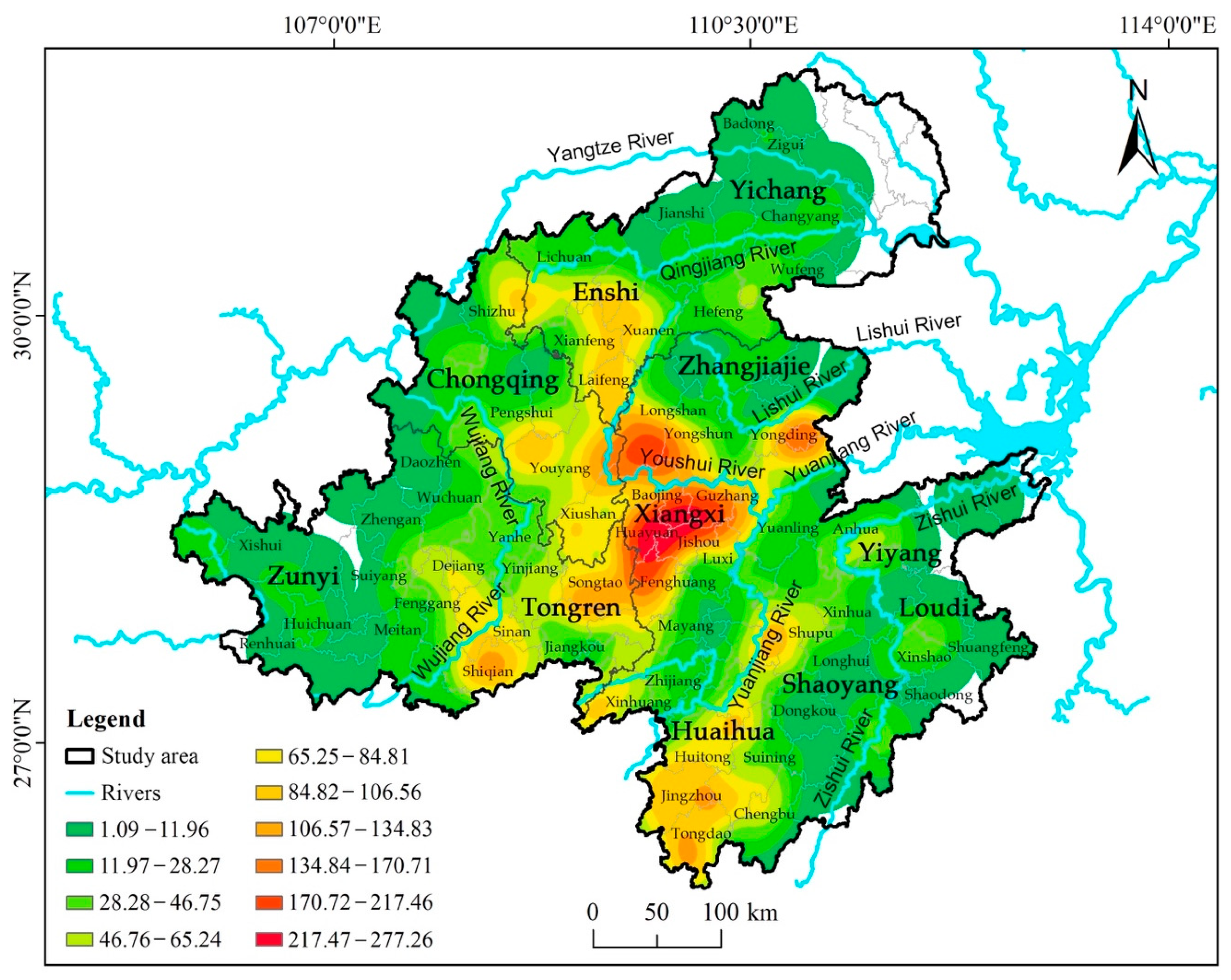
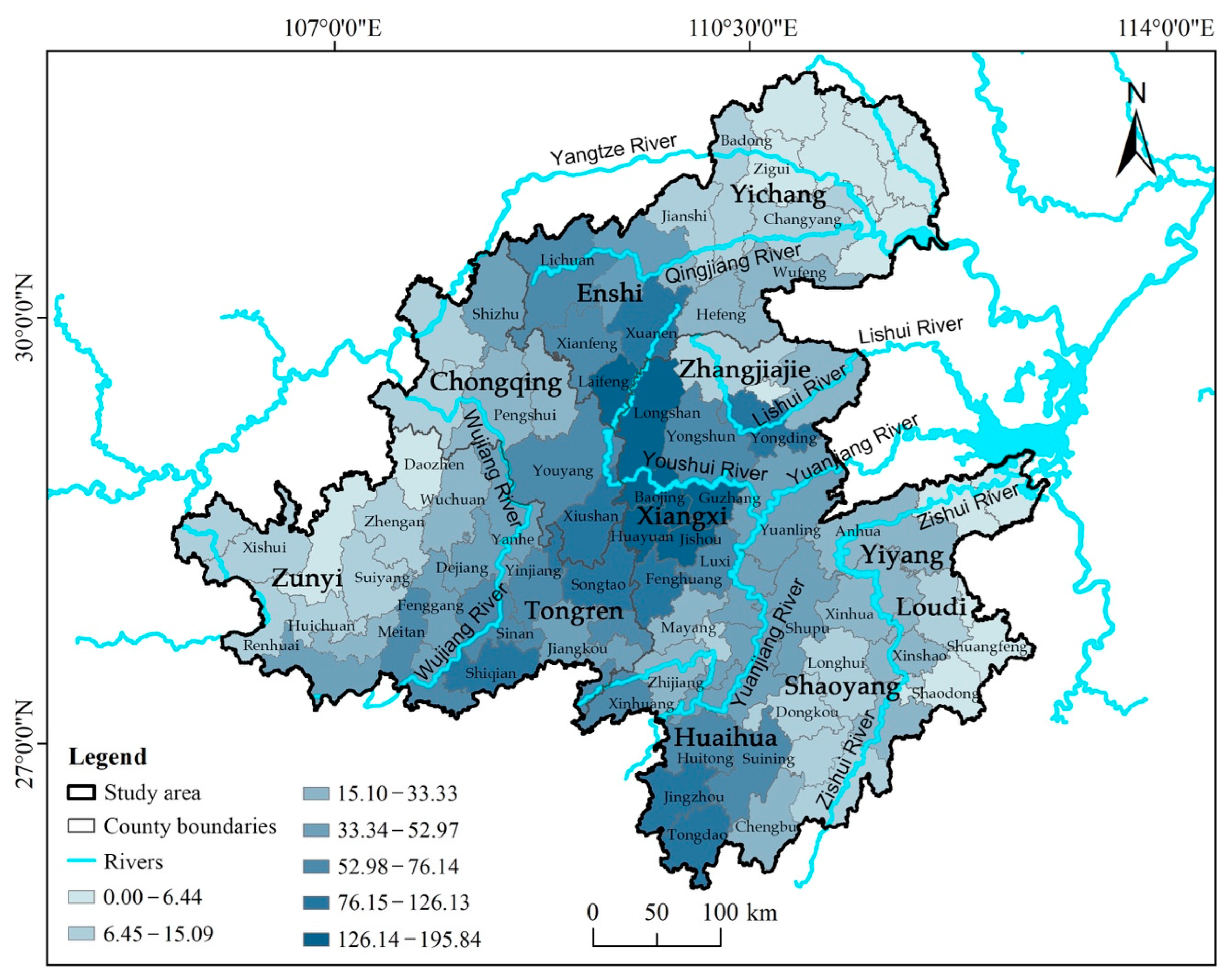
The study applied PDE to visualize the spatial concentration degree of Ganlan and quantify its density distribution weight. Figure 6 illustrates a significant influence of geographical conditions on the spatial distribution of Ganlan in the Wuling Corridor. As shown, Ganlan are concentrated on both sides of the 6 major river systems, with several Ganlan clusters connected to form cluster belts along the river courses. These cluster belts serve as important centers of the regional population distribution patterns. Specifically, the primary center is located along the Youshui River at the junction of Hunan, Hubei, and Chongqing, and the secondary centers are located along the Yuanjiang River, Lishui River, and Wujiang River. At county scale, in terms of the density of Ganlan, the top five are Huayuan (195.84), Jishou (188.13), Guzhang (156.73), Longshan (144.59), and Fenghuang (125.91), all situated in the Youshui River basin (Xiangxi Tujia and Miao Autonomous Prefecture, Hunan; Table 2). According to Figure 7, other areas such as Xuan’en County and Laifeng County in the upper reaches of the Qingjiang River and Youshui River (Enshi Tujia and Miao Autonomous Prefecture, Hubei), Yongding District along the Lishui River (Zhangjiajie City, Hunan), Jingzhou County and Tongdao County along the Yuanshui River (Huaihua City, Hunan), Shiqian County along the Wujiang River (Tongren City, Guizhou), and Xiushan County along the Youshui River (Chongqing Municipality) also exhibit pronounced spatial polarization. Apart from these clusters, the distributions of Ganlan elsewhere are relatively discrete, with large numerical fluctuations.

5.2. Distribution Characteristics by Ethnic Attributes

5.2.1. Number

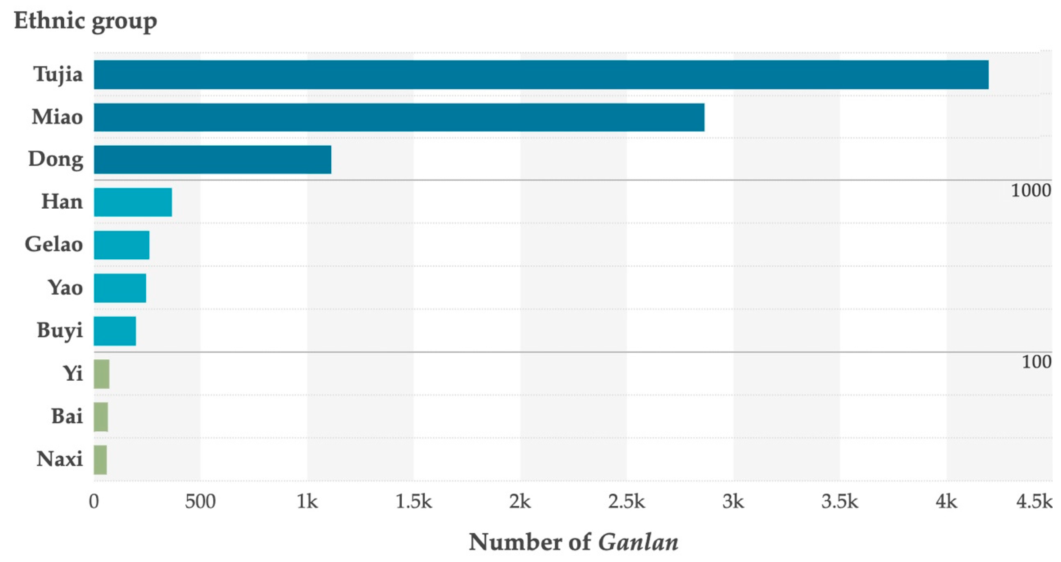
In the Wuling Corridor, the data show that the distribution of Ganlan covers 10 ethnic groups. According to the quantity ranking in Figure 8, the ethnic groups possessing more than 1000 Ganlan buildings include Tujia (4196, 44.5%), Miao (2863, 30.4%), and Dong (1113, 11.8%), accounting for 86.7% of the total; the ethnic groups possessing 101~1000 include Han, Gelao, Yao, and Buyi, accounting for 11.3%; the ethnic groups possessing fewer than 100 include Yi, Bai, and Naxi, accounting for only 2%. The disparity between maximum and minimum values is significant, particularly that between Tujia and Naxi, which far exceeds the median of fluctuation, indicating a highly uneven distribution of Ganlan by ethnicity. It should be noted that this imbalance of Ganlan samples is positively correlated with the uneven distribution of ethnic population sizes within the region.

5.2.2. Spatial Distribution and Direction

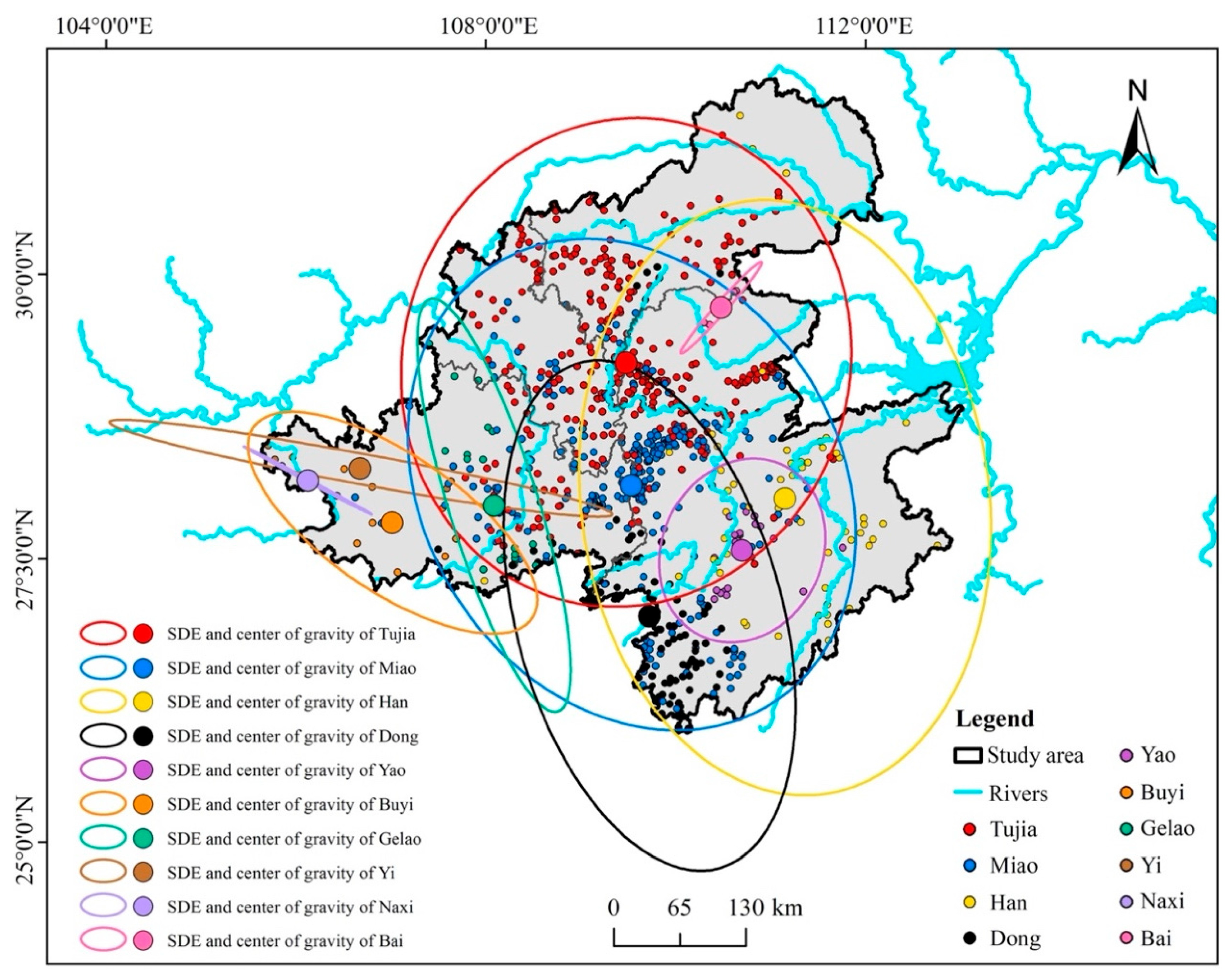
Figure 9 shows that in the Wuling Corridor, Ganlan buildings of 10 ethnic groups present interwoven, embedded distribution patterns. Accordingly, the study used SDE analysis to quantitatively characterize the distributions of Ganlan owned by the 10 ethnic groups, Figure 10 shows the analysis results. In terms of diffusion directions of SDE, the geographical distribution of Ganlan owned by each ethnic group is highly directional, with the distributions of Ganlan owned by 6 ethnic groups exhibiting a general “south-to-north” diffusion trend (Azimuth Angle θ: 2.1°~5.9°). In terms of area of SDE, the Ganlan owned by Han are most widely distributed across the Wuling Corridor, followed by those owned by Miao, Tujia, Dong, and others. In terms of discrete degree and centroid position of SDE, Tujia possesses the largest proportion of Ganlan, and the distribution is most concentrated (Ellipticity: 0.09). Tujia Ganlan are primarily located in the central and northern parts of the Wuling Corridor, and the centroid is at the junction of Hunan, Hubei, and Chongqing. Yao Ganlan have the second-highest concentration (Ellipticity: 0.17), mostly distributed in the middle reaches of the Yuanshui River, with the centroid located in Chenxi County, Hunan. Miao Ganlan are concentrated in the central part of the Wuling Corridor (Ellipticity: 0.19), with the centroid located in Fenghuang County, Hunan. Han Ganlan are most widely distributed along the “south-to-north” direction (Ellipticity: 0.32), with the centroid located in Xupu County, Hunan. The others, in order, are Dong Ganlan (Ellipticity: 0.49; Centroid: Huitong County, Hunan), Buyi Ganlan (Ellipticity: 0.5; Centroid: Zunyi City, Guizhou), Gelao Ganlan (Ellipticity: 0.79; Centroid: Dejiang County, Guizhou), Bai Ganlan (Ellipticity: 0.87; Centroid: Sangzhi County, Hunan), Yi Ganlan (Ellipticity: 0.94), and Naxi Ganlan (Ellipticity: 0.96). Yi and Naxi Ganlan are the most discretely distributed in Zunyi City, Guizhou, along the “west-to-east” direction. In summary, despite that the centroids of the spatial distributions of Ganlan owned by different ethnic groups are mutually independent, the distribution ranges are largely overlapped, implying that Ganlan is an architectural and residential mode shared by all ethnic groups in the Wuling Corridor and characterized by significant spatial connectivity and cultural sharing among ethnic groups.

5.3. Distribution Characteristics by Type Attributes

5.3.1. Number

Figure 11 and Figure 12 demonstrate remarkable differences in the number of the three types of Ganlan. The dominant Type-II Ganlan accounts for nearly half of the total (4273, 45.3%), involving all 10 ethnic groups and four provincial-level administrative divisions in the Wuling Corridor, followed by Type-III Ganlan (3481, 36.9%), involving 5 ethnic groups and four provincial-level administrative divisions, and Type-I Ganlan (1671, 17.8%), involving 7 ethnic groups and 2 provinces.

5.3.2. Spatial Distribution and Direction

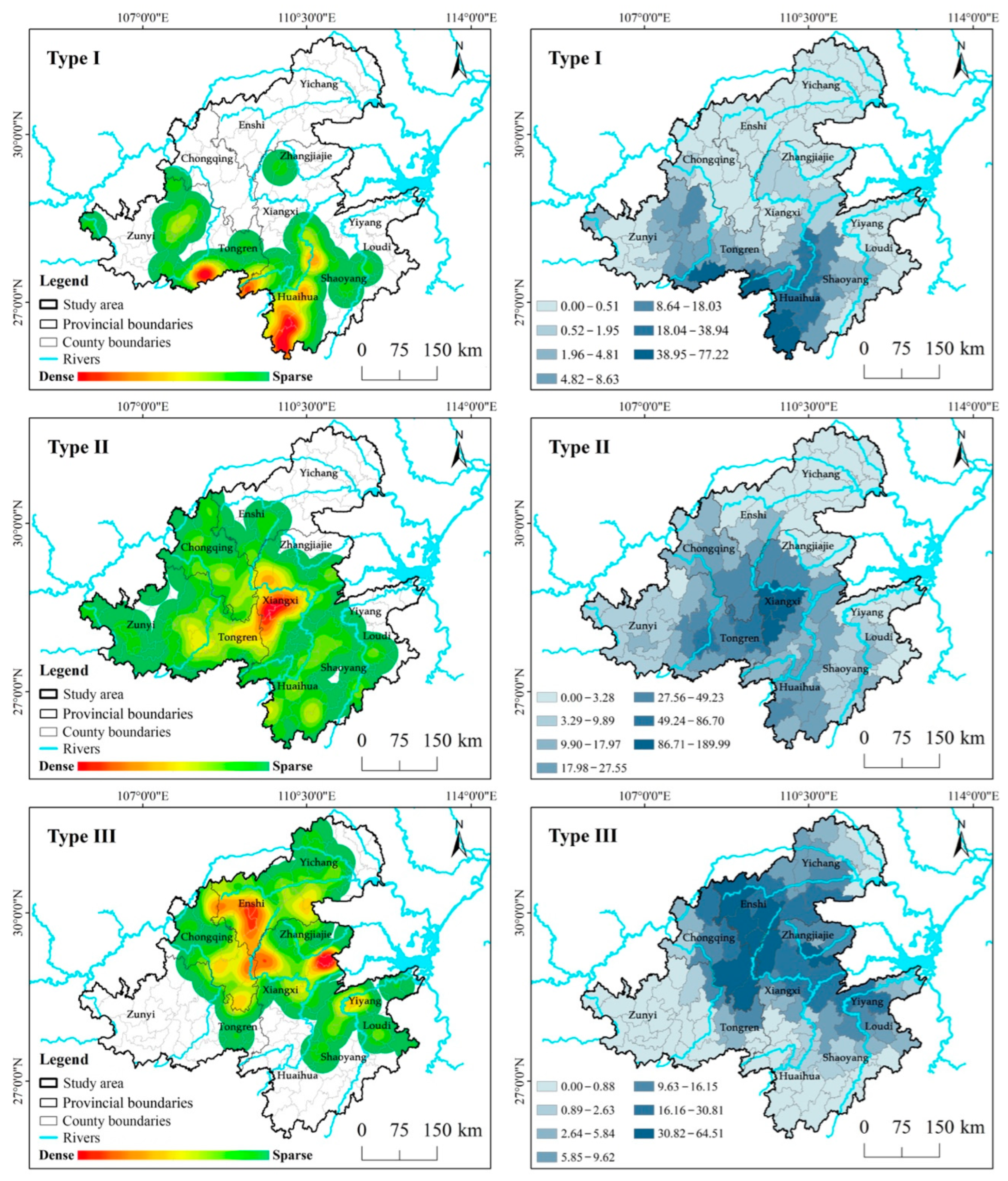
As shown in Figure 13, Ganlan Type I~III in the Wuling Corridor exhibits a “west-to-east, south-to-north” geospatial distribution trend and pattern. Based on the density characteristics (Figure 14), it can be known that Type-I Ganlan are mainly distributed along the Yuanshui River and Wujiang River in the southwestern part of the Wuling Corridor, showing strong spatial polarization in Jingzhou Miao and Dong Autonomous County, Tongdao Dong Autonomous County, and Xinhuang Dong Autonomous County in Huaihua City (Hunan), as well as Shiqian County in Tongren City (Guizhou). The ethnic groups involved, ranked by the number of Ganlan possessed, are Dong, Miao, Gelao, Yao, Buyi, Yi, and Naxi. Type-II Ganlan have the widest distribution, covering most areas except the northeastern part of the Wuling Corridor. The primary density centers are Fenghuang County, Huayuan County, and Jishou City in Xiangxi Tujia and Miao Autonomous Prefecture (Hunan) on the south bank of the Youshui River, while the secondary centers are located along the Yuanshui River and Wujiang River. All 10 ethnic groups in the Wuling Corridor own this type of Ganlan, the ranking is Miao, Tujia, Dong, Han, Buyi, Yao, Naxi, Yi, Gelao, and Bai. Type-III Ganlan are mostly located in the northeastern part of the Wuling Corridor. The primary density centers are in Xiushan Tujia and Miao Autonomous County and Youyang Tujia and Miao Autonomous County in Chongqing Municipality and Laifeng County, Xuan’en County, and Xianfeng County in Enshi Tujia and Miao Autonomous Prefecture, Hubei, showing a northward shift along the Youshui River. The spatial polarization is most pronounced there. The secondary center is Yongding District (Zhangjiajie City, Hunan), along the Lishui River. The Tujia group owns the largest proportion of Type-III Ganlan (87.5%), followed by Han, Miao, Bai, and Dong.
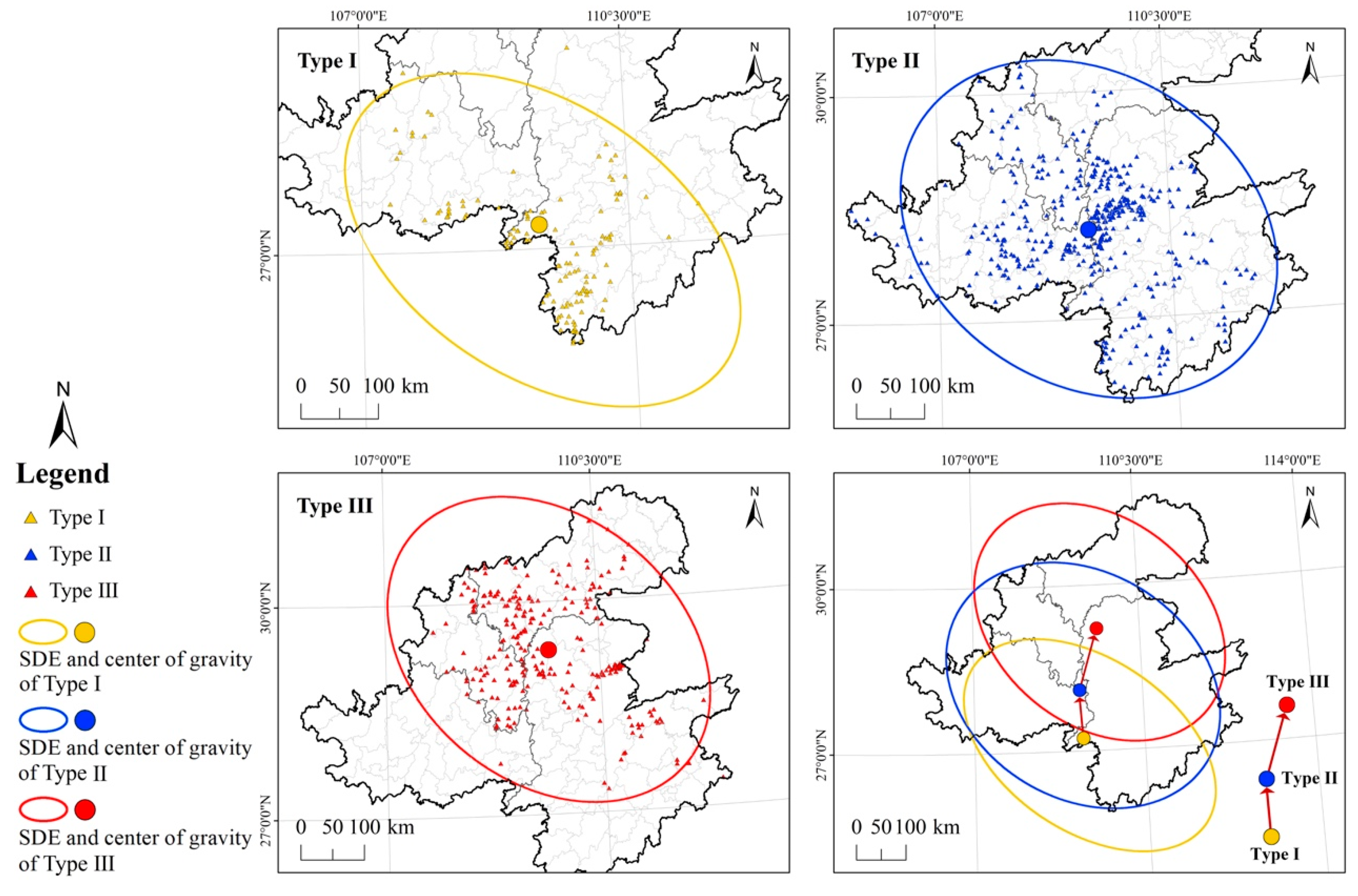
The SDE analysis results for the three Ganlan types are shown in Figure 15. In terms of diffusion directions, they all exhibit a relatively consistent “southeast-to-northwest” trend (Aimuth Angle θ: 42.4°~44.7°), demonstrating strong directionality. In terms of discrete degree, Type-II exhibit the most concentrated distribution (Ellipticity: 0.14), followed by Type-III (Ellipticity: 0.25) and Type-I (Ellipticity: 0.44). In terms of centroid position, the distribution centroids of Type-I, Type-II, and Type-III are located in Xinhuang County (Huaihua City, Hunan), Longshan County (Xiangxi Autonomous Prefecture, Hunan), and Fenghuang County (Xiangxi Autonomous Prefecture, Hunan), respectively. In light of the centroid movement from Type I to Type III, the distribution of each type of Ganlan is relatively concentrated. Although their spatial ranges exhibit some overlap, the degree of mutual embedding is low, indicating regional independence between different types of Ganlan regarding their development and evolution. Also, it shows distinct “west-to-east, south-to-north” spatial continuity.

5.4. Evolutionary Pattern

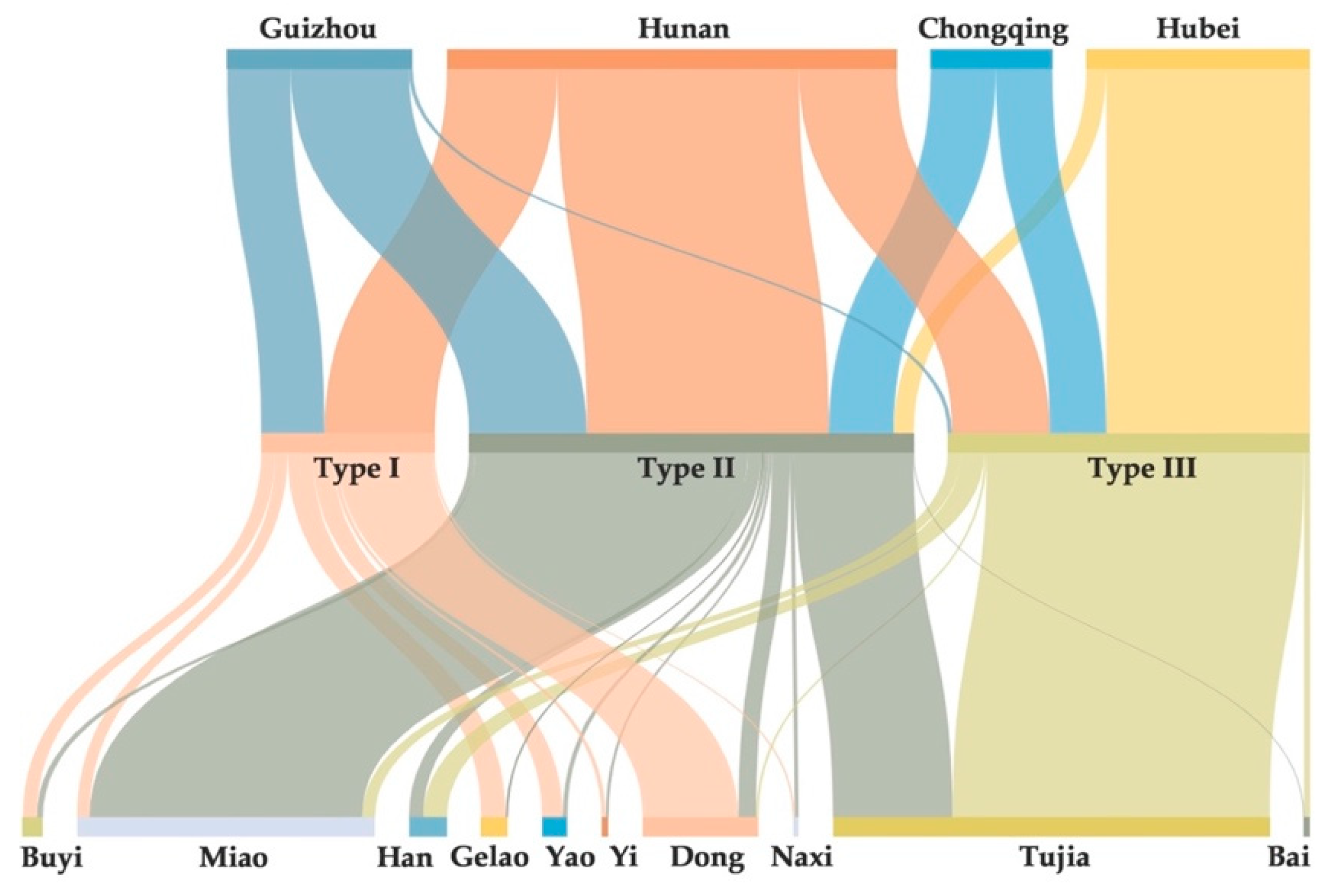
Figure 16 illustrates the spatial data flows of 9425 Ganlan buildings in the Wuling Corridor. The differential characteristics are significant regarding provincial-level administrative divisions, ethnic groups, and types. Nodes on different dimensions exhibit clear interleaving and coupling relationships in terms of data path and volume. From the provincial-level administrative divisions dimension, the data flows are subject to significant spatial agglomeration and segregation. From the ethnic group dimension, there are magnitude differences of strength in the connections between ethnicity nodes and the number of Ganlan. From the type dimension, the data flows of different tributary types of Ganlan are highly differential. This multi-dimensional difference analysis provides an important basis for visualizing the spatial association and evolutionary pattern of each type of Ganlan.
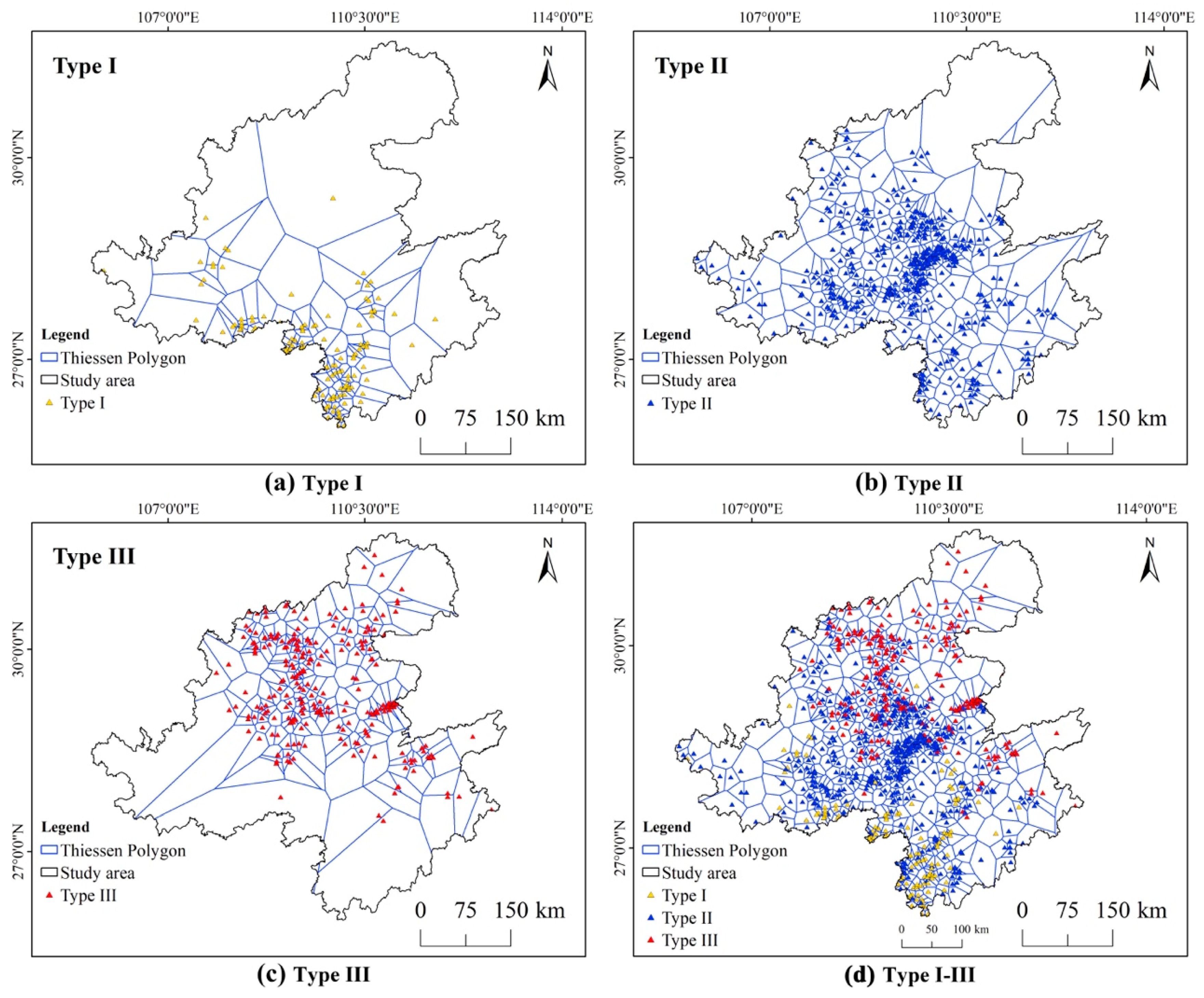
In Figure 17 and Table 3, Thiessen polygons are used to quantify the radiation scopes and influence areas of the three types of Ganlan, as well as their spatial association with each other. According to the cluster analysis results of spatial and construction attributes in the earlier Figure 4, it can be observed that the spatial distribution of Type-I to Type-III also reflects the evolutionary sequence of Ganlan types. Type-I (full-Ganlan) are distributed as clusters at the southwestern end of the Wuling Corridor, with a coefficient of variation (CV) of 1.08. Fully raised from the ground, this type of Ganlan features wooden column-and-tie construction and typically has 2 or three stories, representing the traditional Ganlan style in Southwest China. Type-II (semi-Ganlan) have the lowest CV and SD values (0.31, 0.289), suggesting that it is most evenly distributed. According to the sample data, the two indicators of percentage of raised-floor area (BA-S-6) and column feet height (BA-C-3) among this type can be highly inconsistent, manifest the evolution from full-Ganlan to semi-Ganlan, which are partially elevated and partially grounded. To some extent, Type-II represents a transition. Type-III (courtyard-style Ganlan) have an increased CV value of 0.72, indicating strong clustering. This is because of the fact that Type-III are located at the edge zones of the ethnic ghettos in Southwest China and at the convergence zone between minority and Han cultures, which restricts the diffusion of Ganlan residential form. In this process, the influence of Central Plains Han architectural culture has increasingly strengthened, resulting in a combination of Ganlan and courtyard forms. The spatial configuration of Ganlan has also evolved into a courtyard-style layout resembling Sanheyuan (three-sided courtyard) and Siheyuan (four-sided courtyard).
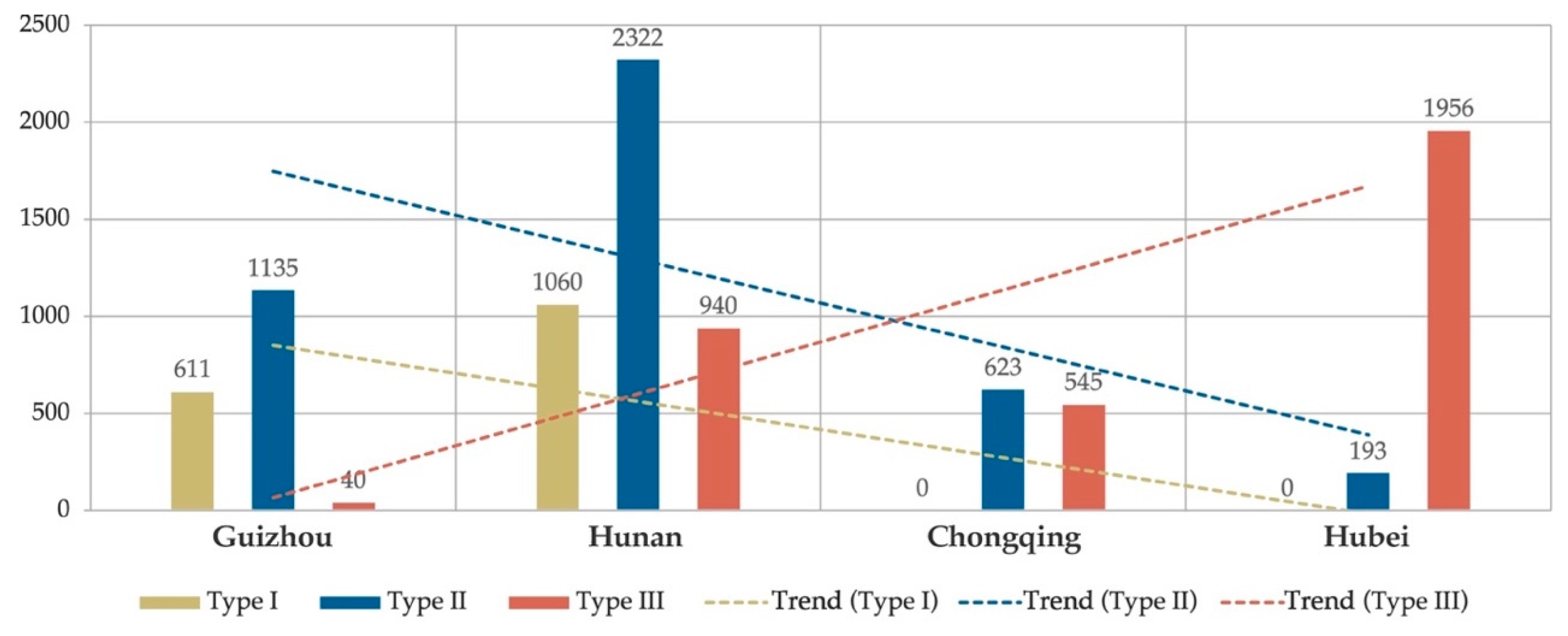
Following the “west-to-east, south-to-north” spatial continuity of the three Ganlan types demonstrated previously, Figure 18 further reveals the development trends of the three Ganlan types reflected by the distribution changes of Ganlan numbers along the “Guizhou→Hunan→Chongqing→Hubei” route. Specifically, along the route, the number of Type-I and Type-II is on a declining trend. The coefficient of determination (R2) for Type-I is 0.526, and no Type-I is found in Chongqing and Hubei, indicating a fundamental change in external conditions or internal mechanisms. This downtrend is unconventional and terminal. The R2 for Type-II is 0.403, with a relative decline exceeding 69%. Despite Type-II still being found in Hubei, the final data drops from the peak to the minimum (193), exhibiting a significant, profound downtrend. In contrast, the number of Type-III exhibits a notable linear upward trend, with an R2 of 0.724 and an average increase of approximately 535.3 units per phase, demonstrating a marked rate of growth within the region.
Thus, Type-I to Type-III in the Wuling Corridor not only signify the typological differentiation of Ganlan as an architectural form shared by multiple ethnic groups across administrative divisions but also delineates their path of evolution along the geospatial continuity. From west to east and from south to north, starting with the full-Ganlan characterized by column-and-tie construction, prevalent among the Dong, Gelao, and Yao ethnic groups in Guizhou and southern Hunan; transitioning to the semi-Ganlan, partially elevated and partially grounded, predominantly found among the Miao and Tujia ethnic groups across most areas of Hunan, Hubei, Chongqing, and Guizhou; and finally evolving into the courtyard-style Ganlan, deeply influenced by the Central Plains courtyard layout, represented by the Tujia ethnic group in the border regions of Hunan, Hubei, and Chongqing. This dynamic evolutionary trend observed from west to east and south to north within the region—characterized by the gradual disappearance of full-Ganlan, the decline of semi-Ganlan, and the continuous rise of courtyard-style Ganlan—demonstrates that the development of Ganlan does not follow a simple linear model. Instead, it reveals the resilience mechanisms inherent to Ganlan as a local living landscape. This process reflects not only the architectural system’s adaptive adjustments to diverse natural environments but also its intrinsic vitality, as it is continuously shared and reinvented through multi-ethnic cultural integration in response to socio-cultural changes over time. Thus, it profoundly illustrates the capacity of human settlement systems to achieve sustainable development through self-adaptation under complex natural and social conditions.

6. Discussion: Driving Factors on the Formation of Local Residential Landscapes

6.1. Natural Geographical Factors

6.1.1. Climate

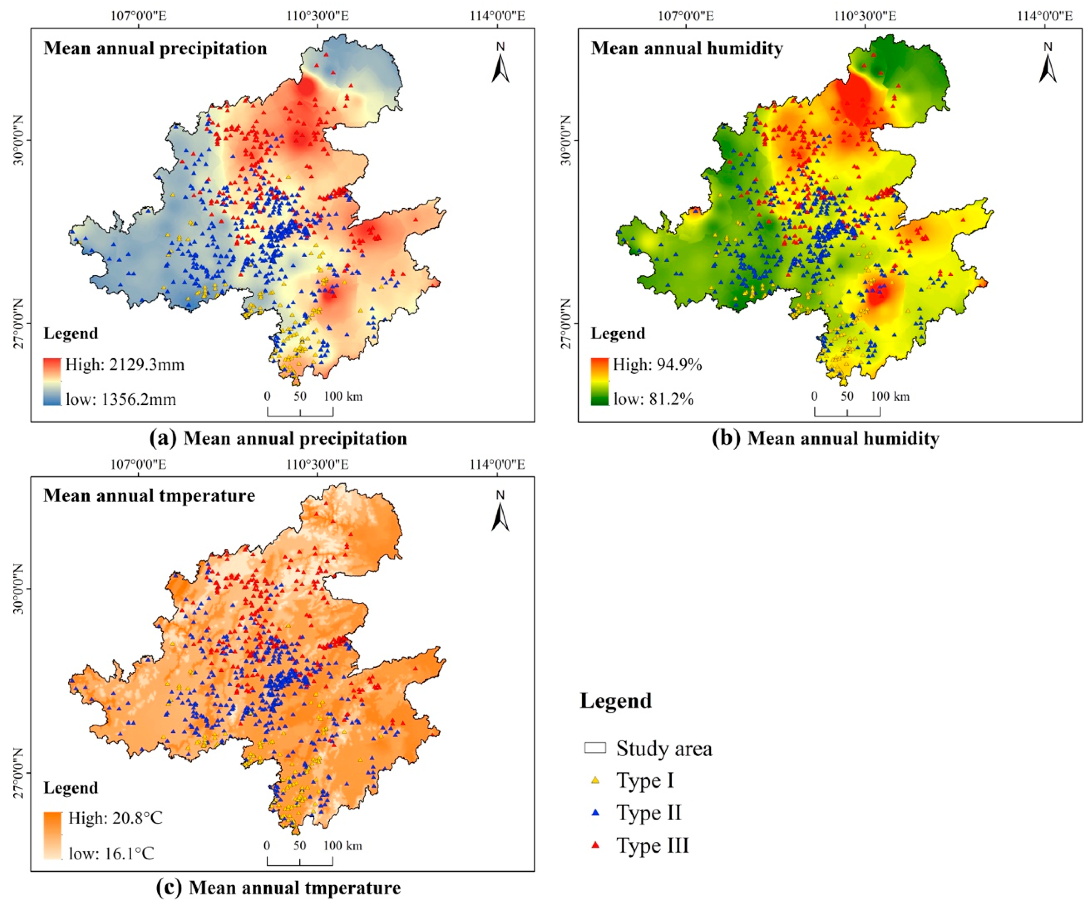
The morphological characteristic of Ganlan—a raised living floor—originally emerged as ancestor’s adaptative response to the humid and rainy climate south of the Yangtze River in China [32]. Therefore, as the starting point for shaping the form of Ganlan, climatic conditions are directly linked to their geospatial distribution. Figure 19 illustrates the influence of mean annual precipitation, mean annual humidity, and mean annual temperature on Ganlan distribution in the Wuling Corridor.
As shown in Figure 19a, precipitation is the cardinal climatic factor affecting Ganlan distribution. Ganlan in the Wuling Corridor are principally concentrated in rainy regions with a mean annual precipitation exceeding 1450 mm. Areas like Enshi City in Hubei, Yiyang City in Hunan, Shizhu County in Chongqing, and Tongren City in Guizhou typically experience a mean annual precipitation between 1600 and 2150 mm. These regions experience abundant rainfall and prolonged rainy seasons, often leading to surface water accumulation and damp soil. The elevated base structure of Ganlan effectively prevents direct contact between the house and the ground. In particular, most of the Ganlan in Fenghuang County (Xiangxi Autonomous Prefecture, Hunan) are built along rivers. In response to seasonal water level changes, the heights of column feet typically reach 3.1 to 4.8 m to facilitate flood passage and mitigate erosion on the main structure. Figure 19b further demonstrates that high-humidity environments enhance the adaptive advantages of Ganlan. The karstic Wuling Corridor is subject to a relative humidity of above 80% throughout the year. This indicator reaches over 93% in places like Wufeng County (Yichang City, Hubei) and Longhui County (Shaoyang City, Hunan). The bottom air layer of Ganlan helps reduce the impact of humidity on wooden structures and indoor living conditions. Figure 19c illustrates how temperature conditions indirectly affect Ganlan distribution by influencing living comfort. The Wuling Corridor has a subtropical climate, with high temperatures persisting for most of the year, especially in summer. The mean annual temperature ranges between 16.1 and 20.8 °C, and the mean annual maximum temperature exceeds 30.9 °C. The air layer and the pitched roof jointly create a “chimney effect”, which properly facilitates the expulsion of hot air in summer. In winter, when the temperature is low and the humidity is high, residents can use fire pits integrated in the Ganlan system for heating. Ganlan satisfies the need for winter protection and helps defend the longstanding seating customs in some areas.
It is noteworthy that although climate is considered the initial condition for the formation of Ganlan forms, the analysis of climatic adaptability also reveals the nonlinear characteristics of cultural landscape evolution. The spatial distribution of Type I (full-Ganlan), which is the most representative of climatic adaptation, shows a spatial discrepancy with the core areas of the most humid and hot climate within the region. This phenomenon is also a result of the co-evolution of “environment–culture”: the form of Type I originated as a prototype adaptation to the humid and hot environment, while its current spatial distribution pattern is the combined outcome of initial environmental drivers and the intensity of ethnic-cultural interactions (this will be specifically discussed in Section 6.2 Historical and Cultural Factors).

6.1.2. Topography

Topography is another core factor affecting the spatial distribution pattern of Ganlan in the Wuling Corridor. Dominated by karst landforms, the Wuling Mountains stretch from southwest to northeast, featuring high mountains and deep valleys with a relative relief reaching up to 1000 m. Strongly incised by river systems such as the Wujiang River, Yuanjiang River, and Lishui River, the Wuling Mountains boast marvelous mountain-gorge landscapes. Topographic factors like elevation and slope exhibit significant spatial coupling with Ganlan distribution. These factors not only influence the site selection and morphological adaptation of Ganlan but also contribute to the distinct regional differentiation characteristics and the formation of residential landscapes.
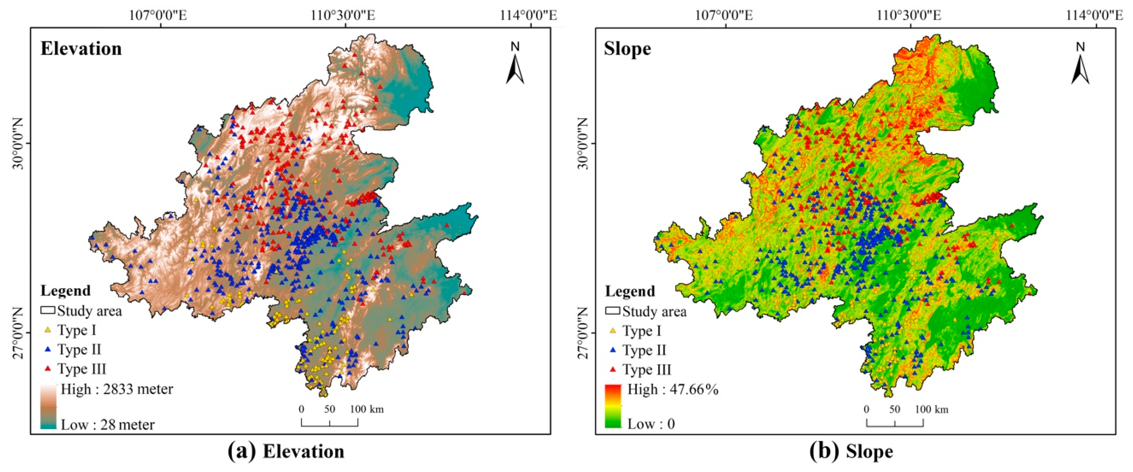
Figure 20a shows that the vertical distribution density of Ganlan is directly related to elevation. In the Wuling Corridor, Ganlan are most concentrated in mountains and river valleys with an elevation between 500 and 1680 m. Type-I Ganlan are primarily located in the mountainous areas with an elevation from 480 to 800 m. These areas are dominated by shallowly incised medium-low mountainous landforms. The distribution elevation of Type-II Ganlan ranges from 550 to 1150 m. Notably, although Type-III Ganlan are found in high-altitude mountains, due to the complex combination of extreme landforms (e.g., small basins, mesas, high mountains, deep valleys, and steep slopes), most of Type-III Ganlan are built in areas below 1200 m. Figure 20b demonstrates slope as a key indicator for the structural adaptability of Ganlan. Overall, the Wuling Corridor has great topographic relief, with a maximum slope of 47.7%, and Ganlan are mostly distributed on gentle-to-moderate slopes (10°~30°). Nevertheless, owing to the adjustable column feet, they exhibit high flexibility and adaptability to slope changes, thereby avoiding large-scale land leveling, as well as water and soil erosion resulting from the practice. For instance, about 102 Ganlan buildings in Disun Miao Village (Jingzhou Autonomous County, Huaihua City, Hunan) are laid out parallel to the contour lines, with the heights of column feet adjusted according to the slope, forming a terraced village landscape exhibiting extraordinary adaptability to the terrain (Figure 21). Some Ganlan buildings in Xiangxi Autonomous Prefecture (Hunan) have their column feet standing in the Tuojiang River, extending the living space from the steep terrain to above the water, creating a unique waterside residential landscape (Figure 22).
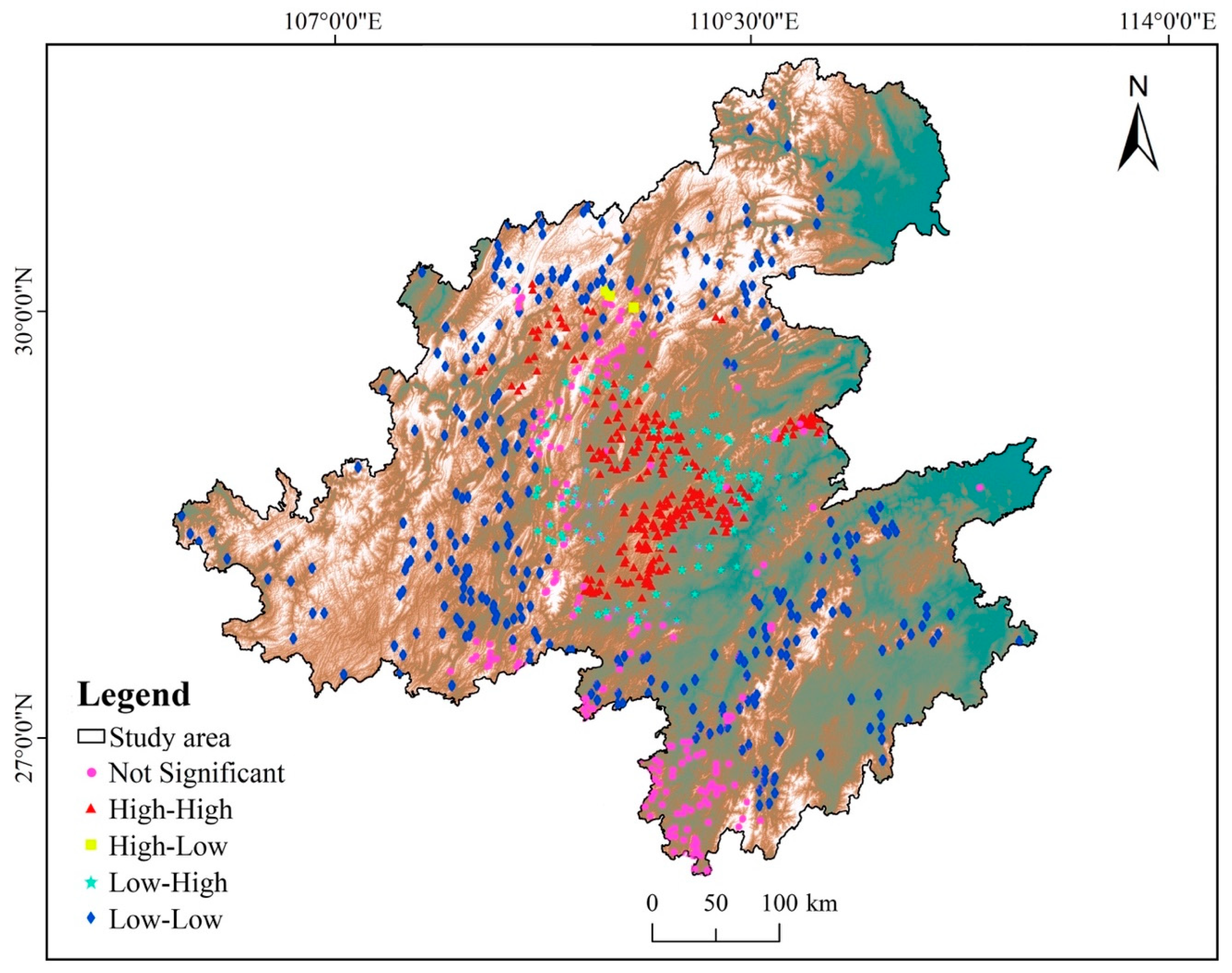
Through the further analysis of spatial autocorrelation characteristics of Ganlan distribution in the Wuling Corridor are identified, the LISA cluster analysis is shown in Figure 23. From the elevation dimension, High-High (HH) and Low-Low (LL) Ganlan clusters are predominant, followed by Low-High (LH) Ganlan clusters. High-Low (HL) Ganlan clusters are less common. Specifically, HH Ganlan clusters are mainly distributed in 19 county regions (e.g., Longshan, Huayuan, Fenghuang, Jishou, Yongding, Laifeng, and Xuan’en); LL clusters are primarily distributed in 23 county regions (e.g., Xinhua, Anhua, Shaoyang, Yinjiang, Pengshui, and Fenggang); LH clusters are mostly distributed in 10 county regions (e.g., Jiangkou, Chenxi, Yuanling, Youyang, and Qianjiang). Approximately 32.4% of the Ganlan in the Wuling Corridor show no significant clustering, implying that nearly one-third of the Ganlan are discrete. Thus, the topography of the Wuling Mountains has a dual role of both separating and aggregating Ganlan and villages.

6.2. Historical and Cultural Factors

6.2.1. Ethnic Migration

In light of archaeological evidence, the earliest known remains of Ganlan, dating back 7000 years, have been found in the middle and lower reaches of the Yangtze River and the areas south of it (e.g., the Hemudu and Majiabang Sites). The prototype of Ganlan can also be traced back to the primitive “nest dwellings” in this region of river networks and marshes [33]. Baiyue, as the indigenous ethnic group, gradually developed mature Ganlan construction techniques and living patterns in response to the moist and water-rich environments. From the Neolithic Age to the Shang and Zhou Dynasties, Baiyue culture was extensively prosperous in Southeast China. Since the Han Dynasty, with the continuous migration of the Baiyue people [34], Ganlan construction techniques began to spread and diffuse outward from the original cultural sphere. This process profoundly influenced the subsequent spatial distribution pattern of Ganlan architecture.
Based on the historical trajectory of Baiyue’s westward migration, this study used the geographically weighted regression (GWR) model to quantitatively analyze the spatially heterogeneous impact of the migration trajectory index on the Ganlan distribution index. According to Figure 24, the fitting between the two indices is highly positive, with an R2 between 0.55 and 0.57, demonstrating a strong linear correlation between Ganlan distribution and Baiyue migration, as well as a significant impact of the latter on the former. Throughout history, large-scale migration events such as “Liao People entering Shu” which occurred during the period from the Western Jin to the Northern and Southern Dynasties (approximately 302–589 CE), contributed significantly to the westward spread of Baiyue architectural culture. The Liao people were descendants of the “Luoyue”, which was an important branch of the Baiyue group. The “Shu” indicates today’s Sichuan Province. The Book of Wei (Volume 101) also records that in present-day central Sichuan, western Sichuan, and the Xikang region, “they dwell atop structures built by assembling wood around trees, known as Ganlan, the size of which varies according to the number of household members.” As the only passage, the Wuling Corridor witnessed the Liao people traveling westward deep into the Wuling region along the Youshui River, Lishui River, Yuanshui River, and other critical water systems [35]. The migrators brought the Ganlan construction techniques and living customs originating from Baiyue into the Wuling Mountains, from which they continued to spread to Sichuan, Yunnan, and other regions.
The Ganlan architectural paradigm featuring an elevated, stilted living space was originally developed to accommodate to the hot, humid, rainy environments infested with insects and snakes in South China. Entering into the mountainous areas, the Ganlan system exhibited high adaptability to steep terrain, with mountain-adaptive construction techniques such as flexible column feet, staggered floor, and terraces developed [36]. In some areas, it evolved into partially elevated and partially grounded semi-Ganlan and enclosed courtyard-style Ganlan. Thus, these variations (especially the hanging buildings built by Tujia and Miao) constitute unique Ganlan residential landscapes in Wuling Corridor, which differ significantly in the plains.

6.2.2. Cultural Interaction

Cultural interaction is the key driving force for the typological evolution of Ganlan. Along the “east-to-west” ethnic migration, Ganlan first experienced a process of mountain adaptation. Then, following the similar westward spread of Han culture from the Central Plains, the Ganlan forms were further evolved. In this case, interaction intensity with Han culture involves four influence factors: administrative jurisdiction, migration and reclamation, commercial trade, and geographical proximity. Following the gradient of interaction intensity from low to high, the architectural complexity, enclosure of plane layout, building material durability, structural form, and complexity of joint construction for all three types of Ganlan show a significant uptrend, while indicators such as the column feet height, interface openness, percentage of raised-floor area, and fire pits importance show a downtrend.
In general, Type-I Ganlan are distributed in the southernmost part of the Wuling Corridor, used by Dong, Miao, Gelao, and Yao. This Ganlan form is basically consistent with the traditional Ganlan form built by Miao and Yao in Guizhou, Guangxi, and other divisions, representing a typical example of Ganlan in Southwest China. Nevertheless, the “bay” concept from Han architectural culture (with three bays being the most common, accounting for 91.2% of the total area) can be found in Type-I Ganlan. These Ganlan exhibit a typical Han architectural pattern of “one primary room with two secondary rooms”. In regions where Type-II Ganlan are distributed, troop stationing, bureaucratization of native officers, and commercial trade during the Ming and Qing Dynasties contributed to the frequent cultural exchanges between ethnic groups (e.g., Miao, Tujia, and Dong) and the Han people from the Central Plains. Thus, influenced by Han’s ground-dwelling culture, semi-Ganlan combining elevated with ground dwelling were developed, and the importance of the central “fireplace room” declined to 38.3%. In some cases, the “fire pit room” was replaced by the “main hall”, common in Han architecture, which houses the tablets for “Heaven, Earth, Emperor, Parents, and Teachers” for reverence, while the fire pit was reduced to a service facility for heating and cooking [37]. Among all Type-III Ganlan, grounded Ganlan featuring primarily surface structures with the raised Ganlan space as a supplement are mostly used by Tujia, accounting for 97.2%. These Ganlan are at the junction of the Wuling Corridor and the Central Plains, the frontier zone where minority ethnic cultures converge with Central Plains Han culture. Moreover, due to the advancement of the bureaucratization policy and the influx of a large number of immigrants from Jiangxi Province [38], Type-III Ganlan were clearly designed with 1 main room facing south, 2 wing rooms, and courtyards, with the Ganlan system only used for the wing rooms, constituting an architectural model resembling to Sanheyuan, Siheyuan, or other courtyard complexes. This typological evolution process vividly reflects how, influenced by Han culture, Ganlan was incorporated into the Han-style ritual spatial order as a component rather than an independent, dominant form. It demonstrates the dynamic adaptation of architectural forms in the context of cultural interactions.

7. Conclusions

Since UNESCO advocated for the protection of cultural landscapes as heritage resources at the end of the last century, issues such as how to innovatively interpret their spatial logic and formulate conservation strategies have attracted substantial attention [39]. Considering the complexity and variability of the spatial and typological distributions, as well as the formation mechanisms of such distributions, of Ganlan as an architectural heritage in the Wuling Corridor, this study systematically constructs a multi-attribute database involving 9425 Ganlan samples, 4 provincial-level administrative divisions, and 10 ethnic groups. Comprehensively, it employs the GIS and clustering algorithms to explore the spatial distribution patterns, distribution characteristics, and underlying distribution mechanisms of Ganlan from a holistic, dynamic perspective. It expounds the coupling relationships of Ganlan distribution with natural geographical and historical cultural factors, thus providing a scientific basis for the holistic conservation of these cross-ethnic architectural heritages and the integrated development of local cultural tourism industries.
This study still has several limitations. For instance, although a relatively large dataset has been collected, the data primarily rely on currently existing Ganlan buildings, while historical data remain vague and there are currently no effective means to acquire such data. Additionally, the positional accuracy of the study, based on the geometric center coordinates of the smallest administrative unit (village), may introduce certain locational errors (within a 1 km range). Furthermore, the analysis of driving factors did not delve into the influence of historical transportation networks, which warrants further investigation in the future regarding its impact on the spread of Ganlan construction methods.
The main conclusions of this study are as follows:
(1) The spatial distribution pattern of Ganlan architectural heritage in the Wuling Corridor is significantly influenced by geographical conditions. demonstrating clustering characteristics along six major river systems and forming a typical river-dependent residential landscape. The primary density center is located along the Youshui River, with significant spatial polarization identified in Xiangxi Tujia and Miao Autonomous Prefecture, Hunan. In this core area, the number of Ganlan accounts for 19.4% of the total. The secondary centers are located along the Yuanjiang River, Lishui River, and Wujiang River. Apart from these areas, the distributions of Ganlan are relatively discrete.
(2) The data flows of Ganlan in the Wuling Corridor show significant differentiation characteristics in terms of provincial-level administrative divisions, ethnic groups, and types. With respect to regionality dimension, Ganlan are discretely and unevenly distributed across the four provincial-level administrative divisions, with the centroid located at the junction of Hunan, Hubei, and Chongqing. With respect to ethnic groups dimension, the disparity between the maximum and minimum values is significant. Tujia, Miao, and Dong Ganlan account for 86.7% of the total. From the type dimension, the differences in the number of the three types of Ganlan are remarkable. Type-II is the dominant Ganlan type in the Wuling Corridor, accounting for 45.3%, followed by Type-III and Type-I.
(3) The spatial distributions of the three Ganlan types simultaneously reflect the evolutionary sequence and development trajectory of Ganlan within the region. Geospatially, the overall distribution features strong “west-to-east, south-to-north” continuity. The evolutionary sequence is from Type-I Ganlan (traditional full-Ganlan) to Type-II Ganlan (partially elevated and partially grounded semi-Ganlan as a transitional form) and eventually Type-III Ganlan (courtyard-style Ganlan). Along this geospatial trajectory, Type-I Ganlan gradually disappear, the number of Type-II Ganlan decreases, whereas the number of Type-III Ganlan continues to rise.
(4) Ganlan serves as a residential mode shared by multiple ethnic groups in the Wuling Corridor, exhibiting spatially interwoven and embedded distribution characteristics. Although the centroids of the distributions of Ganlan in terms of ethnic groups are mutually independent, the spatial ranges are highly overlapped, proving that Ganlan is an architectural and residential mode shared by all ethnic groups in the Wuling Corridor and characterized by close spatial connectivity and cultural sharing in this multi-ethnic community.
(5) Natural factors constitute fundamental constraints shaping the distribution pattern of Ganlan in the Wuling Corridor. As an architectural form designed to adapt to hot and humid conditions, factors such as precipitation, humidity, and temperature in the Wuling Corridor directly influence the geographical distribution characteristics and adaptive strategies of Ganlan. As the Wuling Corridor features diverse landforms, elevation and slope are key indicators affecting the vertical distribution density and adaptability of Ganlan. According to the findings, a majority of Ganlan are located in mountain and valley areas with an elevation between 500 and 1680 m and on gentle-to-moderate slopes (10°~30°). In addition, the LISA cluster analysis demonstrates the aggregation of High-High (HH) and Low-Low (LL) Ganlan clusters, which further verifies the control effect of topography on Ganlan distribution.
(6) Ganlan distribution in the Wuling Corridor highly coincides with the historical westward migration of the ancient Baiyue. Ethnic migration was the principal driving force for the outward spread of Ganlan construction techniques from the original cultural sphere in history. The GWR analysis indicates a significant linear relationship (R2: 0.55~0.57) between the westward migration trajectory (of Luoyue as a key branch of Baiyue) and Ganlan distribution. This spatial transfer also facilitates the development of adaptive construction techniques in local mountainous areas, which constitute unique Ganlan residential landscapes distinctly different from those in flatland areas.
(7) Cultural interactions serve as the key thrust for the typological evolution of Ganlan in the Wuling Corridor. Upon Ganlan culture being brought to the Wuling Corridor following the ethnic migrations, the original Ganlan form first experienced a process of mountain adaptation and later a stronger transformation under the influence of Han culture. This influence is positively correlated with the interaction intensity, which depends on state governance, migration and reclamation, commercial trade, and geographical proximity, with the Han people. The typological evolution exhibits a pattern from open to enclosed, from fully elevated to mostly grounded, and from randomness to Han-featured ritual symmetry.
As an important ethnic and cultural passage connecting the Central Plains and Southwest China in Chinese history, the Wuling Corridor, where Ganlan are organically distributed following the mountains and rivers to constitute continuous and typical residential landscapes, provides a profound spatial and material subject for studying the distribution and evolution mechanisms of Ganlan as a vernacular architectural and residential mode. This research reveals that Wuling Ganlan is not a static architectural specimen with a single origin but rather a dynamic residential landscape system formed by the fusion between diverse natural geographical elements and ethnic cultures and techniques through long-term human–land interactions. By integrating massive Ganlan heritage data with multiple spatial analysis methods, the study serves as a typical case for understanding the formation patterns of local residential landscapes, as well as the resilience mechanisms (i.e., the adaptability to complex environmental conditions and the nature of multi-ethnic sharing) formed in the process where regional knowledge accommodates to natural environmental conditions and socio-cultural changes.

Author Contributions

Conceptualization, T.M. and T.Z.; Methodology, T.M. and T.Z.; Software, T.M.; Validation, T.M. and T.Z.; Investigation, T.M. and T.Z.; Writing—original draft, T.M.; Writing—review & editing, T.M.; Visualization, T.M.; Supervision, T.Z. All authors have read and agreed to the published version of the manuscript.

Funding

This research was funded by the General Project of the National Social Science Foundation of China (Grant No. 22BMZ073).

Data Availability Statement

The database resulting from this study is currently being expandedas part of an ongoing research process. Although the dataset is still under development, the informationsupporting the findings of this article is available from the corresponding author uponreasonable request.

Conflicts of Interest

The authors declare no conflict of interest.

References

  1. Liu, Z.P. A Brief History of Residential Architecture in China; China Architecture & Building Press: Beijing, China, 2000. [Google Scholar]
  2. Yang, C.M. Eastern Architectural Research; Tianjin University Press: Tianjin, China, 1992. [Google Scholar]
  3. Yang, H.X. The development of early Chinese architecture. Archit. Hist. Theory 1980, 1, 118–141. [Google Scholar]
  4. Zhang, T.; Xu, H.; Wang, C. Self-Adaptability and Topological Deformation of Ganlan Architectural Heritage: Conservation and Regeneration of Lianghekou Tujia Village in Western Hubei, China. Front. Archit. Res. 2022, 05, 865–876. [Google Scholar] [CrossRef]
  5. Zhang, T.; Xu, H.; Wang, C. Ganlan Structure: An Architectural Heritage with Self-adaptability and Topological Regeneration. Herit. Archit. 2023, 1, 1–8. [Google Scholar]
  6. Kee, T.; Chau, K.W. Adaptive reuse of heritage architecture and its external effects on sustainable built environment-hedonic pricing model and case studies in Hong Kong. Sustain. Dev. 2020, 6, 1597–1608. [Google Scholar] [CrossRef]
  7. Jiang, Z.H.; Lin, L. The Evolutionary Perspective on the Origin and Evolution of the Tujia Ethnic Group’s Stilt Houses. Huazhong Archit. 2022, 6, 152–155. [Google Scholar]
  8. Sun, H.W.; Gong, J.J.; Jiang, X. Analysis on the Plane Form and Characteristics of the Traditional Dwellings of the Miao Ethnic Group in Xiangxi. Chin. Overseas Archit. 2022, 6, 64–70. [Google Scholar]
  9. Zhao, Y.H. From “Building Inclined Waterway” to “Constructing Turning Angle”: The Classification Evolution and Construction Translation of the “Ganlan–Courtyard” Type in Wuling Tujia Culture. Decoration 2024, 4, 108–113. [Google Scholar]
  10. Tang, S.K.; Li, X.F. Forty Years of Wuling Ganlan Research in Huazhong University of Science and Technology. New Archit. 2024, 5, 107–112. [Google Scholar]
  11. Liu, J.; Cong, S.Q. The Characteristics and Sustainable Development of the Stilt Houses of the Yao Ethnic Group. Art Masterpiece Collect. 2016, 2, 68–72. [Google Scholar]
  12. Wu, P.; Chen, X.W. Analysis of Ganlan Architecture in Meishan Area—Taking Xinhe County as an Example. Decoration 2017, 9, 124–125. [Google Scholar]
  13. Cao, D.Z. Two Essays on Ganlan Storage Structure. Archaeol. Cult. Relics 2021, 5, 71–78. [Google Scholar]
  14. Min, T.Y.; Zhang, T. Cultural Resilience from Sacred to Secular: Ritual Spatial Construction and Changes to the Tujia Hand-Waving Sacrifice in the Wuling Corridor, China. Religions 2025, 16, 811. [Google Scholar] [CrossRef]
  15. Juan, C.A.T.; Sandra, G.; Soon, K.; Dener, S.; Otavio, C.; Tiago, M.F. An ICT-Enhanced Methodology for the Characterization of Vernacular Built Heritage at a Regional Scale. Int. J. Archit. Herit. 2024, 6, 966–984. [Google Scholar]
  16. Bialostaka, O. Inhabiting a Language: Linguistic Interactions as a Living Repository for Intangible Cultural Heritage. Int. J. Intang. Herit. 2017, 12, 18–27. [Google Scholar]
  17. Liuis, S.; Rocio, O.; Javier, B.; Pilar, O. Integrating Fuzzy Cognitive Maps and the Delphi Method in the Conservation of Transhumance Heritage: The Case of Andorra. Heritage 2024, 7, 2730–2754. [Google Scholar] [CrossRef]
  18. Zuo, J.Y.; Huang, S.M.; Wu, J.L.; Liu, S.L.; Li, Y. Study on Spatial-temporal Distribution and Accessibility of Traditional Villages in Wuling Mountain Area. J. Nat. Sci. Hunan Norm. Univ. 2023, 3, 13–22. [Google Scholar]
  19. Huang, D.S.; Wang, L. Probe into the Influencing Factors of Traditional Settlement Culture in Wuling Area. China Three Gorges Trib. 2020, 1, 23–28. [Google Scholar]
  20. Shen, L. The significance of religious studies on ethnic minorities in the Wuling Ethnic Corridor. Relig. Stud. 2022, 2, 180–187. [Google Scholar]
  21. Huang, B.Q.; Ge, Z.W. On the types of cultural interaction: With a discussion on multicultural interaction in the “Wuling Ethnic Corridor”. J. South-Cent. Univ. Natl. 2009, 3, 17–22. [Google Scholar]
  22. Tulasiewicz, J.; Forsman, E. Everything is old now: A–temporal experiences of the digital in a rural farming co–operative. Time Soc. 2022, 31, 88–109. [Google Scholar] [CrossRef]
  23. Chen, M.Y. Architecture in the Quanjin Area of Guizhou Province: Based on Field Investigation in Zhunan Village, Kaiping City. Kerry Coll. J. 2023, 2, 16–21. [Google Scholar]
  24. Liu, Y.W.; Yong, L.; Liu, X.H. Design and implementation of national basic geographic information management system. Geospat. Inf. 2010, 3, 27–29. [Google Scholar]
  25. Mertel, A.; Zbiral, D.; Zdenek, S.; Horinkova, H. Historical geocoding assistant. Softwarex 2021, 14, 100682. [Google Scholar] [CrossRef]
  26. Lu, G.; Michael, B.; Josef, S. Reflections and Speculations on the Progress in Geographic Information Systems (GIS): A Geographic Perspective. Int. J. Geogr. Inf. Sci. 2019, 2, 346–367. [Google Scholar] [CrossRef]
  27. Cascon–Katchadourian, J.; Alberich–Pascual, J. The Georeferencing of Old Cartography in Geographic Information Systems (GIS): Review, Analysis and Comparative Study of Georeferencing Software. Rev. Gen. Inf. Doc. 2021, 1, 437. [Google Scholar] [CrossRef]
  28. Zhang, Y.K.; Wu, B.; Tan, L.F.; Liu, J.Y. Information visualization analysis based on historical data. Multimed. Tools Appl. 2022, 4, 4735–4751. [Google Scholar] [CrossRef]
  29. Min, T.Y.; Zhang, T. Constructing Local Religious Landscapes: Spatiotemporal Evolution of Tibetan Buddhist Temples in the Tibetan–Yi Corridor. Religions 2024, 12, 1477. [Google Scholar] [CrossRef]
  30. Min, T.Y.; Zhang, T. Bidirectional Transmission Mapping of Architectural Styles of Tibetan Buddhist Temples in China from the 7th to the 18th Century. Religions 2024, 9, 1120. [Google Scholar] [CrossRef]
  31. Li, Y.; Zhang, X.Y.; Zhao, J. Remote sensing image segmentation with Gaussian connection function of Tyson polygon region. Sci. Surv. Mapp. 2022, 47, 142–152. [Google Scholar]
  32. Min, T.Y.; Zhang, T. Coupling adaptation mode and regulation strategy for the wind–thermal climate environment of vernacular dwellings in Jiangnan, China based on regional bioclimatic evaluation. J. Asian Archit. Build. Eng. 2025, 1, 2589–2615. [Google Scholar] [CrossRef]
  33. Zhao, F.X. The cave dwellings of China’s ethnic minorities and their cultural remains. Heilongjiang Ethn. Stud. J. 1997, 3, 68–74. [Google Scholar]
  34. Xu, Z.Y.; Wang, Y.L. The ethnic distribution and cultural identity of the Baiyue people during the Qin and Han dynasties. Zhongzhou J. 2019, 1, 137–141. [Google Scholar]
  35. Li, F.Q.; Wei, Y.X.; Lv, J. “All Rivers Flow into the Sea”: The Historical Picture of the Integration of Baiyue Culture into Chinese Culture. Res. Ethn. Groups Guizhou 2020, 11, 170–181. [Google Scholar]
  36. Zhang, Y.J. Research on the Traditional Housing Form of the Buyi Ethnic Group. Herit. Archit. 2022, 2, 33–44. [Google Scholar]
  37. Chang, Q. Reflection on the Fundamental Category of Heritage Architecture. Herit. Archit. 2016, 1, 44–61. [Google Scholar]
  38. Zhang, L.G. The Seventh Principle of Craftsmanship; China Architecture & Building Press: Beijing, China, 2002. [Google Scholar]
  39. Curk, A.; Petronijević, A.M.; Cvetković, I.; Stajić, D. Preservation of vernacular knowledge and skills as a form of architectural heritage protection in Serbia. J. Asian Archit. Build. Eng. 2025, 2, 1–19. [Google Scholar] [CrossRef]
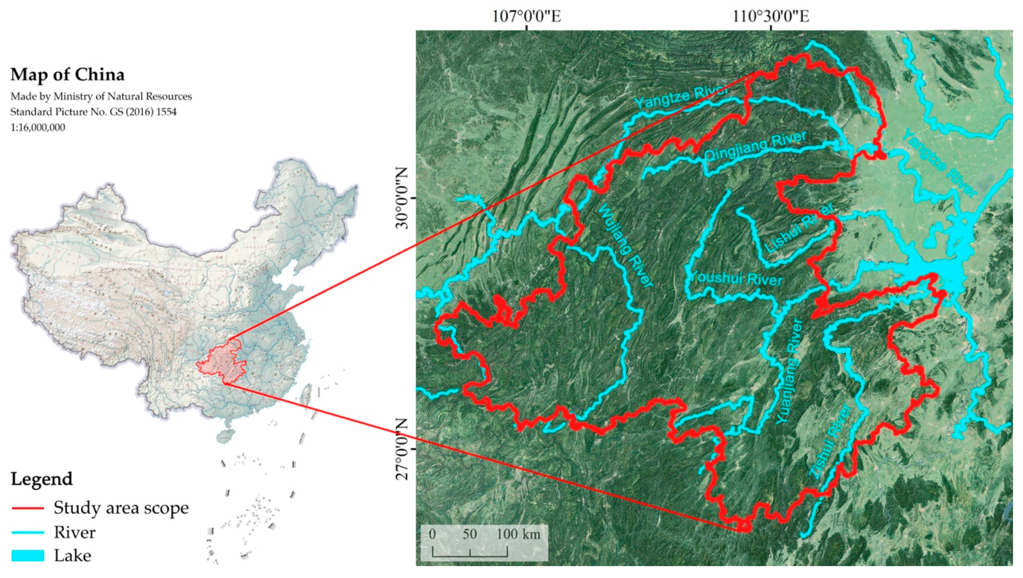
Figure 1. Study area.
Heritage 08 00458 g001
Figure 2. Natural landforms in the Wuling Corridor.
Heritage 08 00458 g002
Figure 3. Residential landscapes in the Wuling Corridor (Enshi, Hubei).
Heritage 08 00458 g003
Figure 4. Clustering analysis results of Ganlan types.
Heritage 08 00458 g004
Figure 5. Distribution of Ganlan numbers across 4 provincial-level administrative divisions.
Heritage 08 00458 g005
Figure 6. Density characteristics of Ganlan distribution.
Heritage 08 00458 g006
Figure 7. Density characteristics of Ganlan distribution at county scale.
Heritage 08 00458 g007
Figure 8. Distribution of Ganlan numbers across 10 ethnic groups.
Heritage 08 00458 g008
Figure 9. Spatial distribution of Ganlan across 10 ethnic groups.
Heritage 08 00458 g009
Figure 10. Standard Deviation Ellipse analysis Ganlan distribution among 10 ethnic groups.
Heritage 08 00458 g010
Figure 11. Distribution of the number of Ganlan buildings by 4 provincial-level administrative divisions across the 3 Ganlan types.
Heritage 08 00458 g011
Figure 12. Distribution of the number of Ganlan buildings by 10 ethnic groups across the 3 Ganlan types.
Heritage 08 00458 g012
Figure 13. Spatial distributions of the three Ganlan types.
Heritage 08 00458 g013
Figure 14. Density characteristics of the distributions of the three Ganlan types.
Heritage 08 00458 g014
Figure 15. Standard Deviation Ellipse analysis of the three Ganlan types.
Heritage 08 00458 g015
Figure 16. Ganlan distribution across provincial-level administrative divisions, ethnic groups, and types.
Heritage 08 00458 g016
Figure 17. Thiessen Polygon analysis of the three Ganlan types: (a) Type I; (b) Type II; (c) Type III; (d) Type I-III.
Heritage 08 00458 g017
Figure 18. Geospatial trends of the three Ganlan types.
Heritage 08 00458 g018
Figure 19. Distributions of Ganlan by Climate: (a) distribution by the mean annual precipitation; (b) distribution by the mean annual humidity; (c) distribution by the mean annual temperature.
Heritage 08 00458 g019
Figure 20. Distributions of Ganlan by topography: (a) distribution by the elevation; (b) distribution by the slope.
Heritage 08 00458 g020
Figure 21. Disun Miao Village, Jingzhou Miao and Dong Autonomous County, Huaihua City, Hunan Province.
Heritage 08 00458 g021
Figure 22. Ganlan along the Tuojiang River in Fenghuang County, Xiangxi Tujia and Miao Autonomous Prefecture, Hunan Province.
Heritage 08 00458 g022
Figure 23. LISA cluster of Ganlan.
Heritage 08 00458 g023
Figure 24. Linear egression analysis of ethnic migration trajectory and Ganlan distribution.
Heritage 08 00458 g024
Table 1. Key characteristics of the three Ganlan types.
Building CodeAttribute LabelsType I (full-Ganlan)Type II (semi-Ganlan)Type III (courtyard-style Ganlan)
Topographic Attribute
(BA-T)
Mountain-dwelling
(BA–T–1)
Typical, with more samplesTypical, with more samplesTypical, with more samples
Water-dwelling
(BA–T–2)
Typical, with more samplesTypical, with more samplesAtypical, with fewer samples
Flatland-dwelling
(BA–T–3)
Atypical, with fewer samplesTypical, with more samplesTypical, with more samples
Spatial
Attribute
(BA-S)
Spatial form
(BA–S–1)
Free and flexible, adapting to the terrainFeatures axial lines and symmetry, though not strictly formalRegular arraged courtyard layouts (Sanheyuan, Siheyuan)
Elevated height
(BA–S–2)
High (2.4~3.0 m)Front section elevated, medium (1.5–2.7 m)Wing rooms elevated at both ends, low (<1.9 m)
Architectural morphology
(BA–S–3)
Fully elevated at the base Partially elevated and partially grounded hybrid form Primarily ground-dwelling, with partial retention of stilted features (e.g., in wing rooms)
Plane layout
(BA–S–4)
Free and flexible, mostly without fixed axes, function-oriented, with the emergence of “bay”Forming the main hall and the “one bright, two dim” layoutStrictly symmetrical layout along the central axis, with clear hierarchical distinctions between the main hall and side rooms
Openness
(BA–S–5)
High, with partially open climate interfaces to the environment Medium, with predominantly enclosed climate interfaces Low, centered around inward-facing courtyards with closed climate interfaces
Percentage of raised-floor area
(BA–S–6)
Extremely high (>85%)Medium (30–70%)Low (<30%)
Entry mode
(BA–S–7)
Side and rear entrances are predominant, with diverse configurations Front-facing entrance appears Front-facing, centrally entrance
Number of bays
(BA–S–8)
Most lack distinct bays, or are determined by functional needsThree-bay layout predominatesThree-bay, five-bay (with wing rooms at both ends)
Construction
Attribute
(BA-C)
Structural form
(BA–C–1)
Column-and-tie timber construction Column-and-tie timber constructionColumn-and-tie timber construction, with some public buildings incorporating post and lintel timber construction
Number of stories
(BA–C–2)
2nd–3rd floor1st–2nd floor1st–2nd floor, with the first floor being typical (or featuring a loft)
Column feet height
(BA–C–3)
High (2.4~3.0 m)Medium (1.5–2.7 m)Low (<1.9 m), ground-level or directly placed on the ground, or resting on a ≤0.3 m low plinth or stone pedestal
Joint construction
(BA–C–4)
Mortise-tenon joint Mortise-tenon joint Mortise and tenon joint, have become more standardized
Building materials
(BA–C–5)
Wood (structures, walls), thatch/bark/small tiles (roofing) Wood (structures, walls), small tiles (roofing) Wood (structures, walls), small tiles (roofing), stone (low pillars)
Number of fire pits
(BA–C–6)
2–3, located at the center of the living space 1–3, positioned off-center or reduced in number 1–2, situated in the wing rooms
Roof pitch
(BA–C–7)
Seven-tenths pitch/Eight-tenths pitch: ratio 7:10 (approx. 35°)/8:10 (approx. 38.7°) Six-tenths pitch: the ratio of roof height to half-span length is 6:10, with a slope of approx. 30.9° Five-tenths pitch: the ratio of roof height to half-span length is 5:10, with a slope of approx. 26.5°
Interior wall height
(BA–C–8)
Height extends to below the post-and-lintel roof truss, or no partition walls are installed, creating a fluid spatial flow Height extends to below the post-and-lintel roof truss, maintaining a degree of fluidity within the interior spaceHeight extends to the roof level, with clear divisions based on room functions, establishing distinct spatial zones
Illustrative photoHeritage 08 00458 i001Heritage 08 00458 i002Heritage 08 00458 i003
Illustrative hand-drawn sketchHeritage 08 00458 i004Heritage 08 00458 i005Heritage 08 00458 i006
Table 2. Weighted density statistics for the spatial distribution of Ganlan at county scale.
Point Density RankingCountry, State, Province/Autonomous RegionAdjacent RiverPoint DensityNumber
of Ganlan
1Huayuan, Xiangxi, HunanYoushui River195.84302
2Jishou, Xiangxi, HunanYoushui River, Yuanjiang River188.13228
3Guzhang, Xiangxi, HunanYoushui River, Yuanjiang River156.73267
4Longshan, Xiangxi, HunanYoushui River144.59285
5Fenghuang, Xiangxi, HunanYoushui River, Yuanjiang River125.91321
6Laifeng, Enshi, Hubei Youshui River101.43384
7Xuanen, Enshi, HubeiYoushui River, Qingjiang River93.52339
8Yongding, Zhangjiajie, HunanLishui River, Yuanjiang River86.18376
9Jingzhou, Huaihua, HunanYuanjiang River85.75261
10Tongdao, Huaihua, HunanYuanjiang River82.49279
11Shiqian, Tongren, GuizhouWujiang River74.27227
12Xiushan, ChongqingYoushui River69.02245
Table 3. Thiessen Polygon parameters of the three Ganlan types.
Minimum Area (10,000 km2)Maximum Area (10,000 km2)Standard DeviationMeanCV
Type I0.0204.7393.0922.1751.08
Type II0.0090.8410.2890.3620.31
Type III0.0171.0160.5450.6710.72
Disclaimer/Publisher’s Note: The statements, opinions and data contained in all publications are solely those of the individual author(s) and contributor(s) and not of MDPI and/or the editor(s). MDPI and/or the editor(s) disclaim responsibility for any injury to people or property resulting from any ideas, methods, instructions or products referred to in the content.