


Abstract
Climate change, altered ecosystems, and expanding development in fire-prone landscapes are increasing fire risk in the wildland–urban interface (WUI). This study uses Noosa, southeast Queensland, Australia, as a case study for a preliminary modeling assessment of irrigated green firebreaks (iGFBs). Using the AMICUS Vesta Mk2 fire-behavior model, fire spread rates and fireline intensity were compared across dry eucalypt control scenarios, non-irrigated green firebreak scenarios, and irrigated green firebreak scenarios receiving 1 and 2 mm m−2 day−1 of water. In line with future climate predictions, these scenarios were compared under progressively worsening fire-weather conditions. The drought-affected dry eucalypt control produced the highest predicted fire spread rates and fireline intensity, and although non-irrigated green firebreak scenarios reduced fire behavior, they may still exceed typical suppression thresholds under catastrophic conditions. In contrast, iGFB scenarios consistently reduced both fire spread rates and fireline intensity across all fire-weather classes. Sensitivity analysis indicated that the model outputs were most responsive to drought- and moisture-related assumptions, supporting the importance of fuel moisture in the performance of the iGFB concept. Although iGFBs are not a stand-alone solution suitable for all settings, the findings provide a preliminary region-specific proof of concept for iGFBs and support the need for further applied research.
1. Introduction
Wildfire extent and intensity are predicted to increase under future climate scenarios, placing growing pressure on existing fire management approaches [1]. These challenges are compounded in wildland–urban interface (WUI) environments, where expanding human development intersects with fire-prone vegetation [2]. Decades of reports, inquiries, and research into Australian fire disasters, including the post-Black Summer 2020 NSW Bushfire Inquiry, have identified the need for enhanced preparedness and mitigation to strengthen disaster risk reduction [3,4,5]. The Australian Productivity Commission notes the considerable cost-benefit of proactive investments, but the ongoing emphasis on reactive measures [6]. As the potential for fire disasters in the WUI increases, complementary options to proactively mitigate fire are needed to enhance preparedness.
Green firebreaks (GFBs) are a proactive option that uses strategically placed low-flammability vegetation to reduce fire spread rates and fireline intensity; however, they could be compromised under extreme conditions [7]. Under climatic heating and drying trends, vegetation near homes is becoming more flammable. Few studies have identified irrigation as a fire mitigation strategy; however, it has been considered for GFBs [8]. Research on GFBs and proactive water management, such as irrigation for wildfire mitigation, is limited in the fire management literature.
While GFBs preserve vegetation but alter fuel availability, conventional firebreaks clear fuels, have ecological trade-offs, and are not considered effective under changing fire conditions, in which drought and high winds transport embers further [9]. There have been simulations of how broad-leaf forests in Europe and China can provide fuel breaks [10,11] and how GFBs in Australia can mitigate fire [12,13]. These are supported by Beaver research in America, which is associated with slowing or stopping fire [14]. In southeast Queensland, rainforests in Lamington National Park have resisted fire along topographical moisture boundaries, as observed in the lack of fire scarring in moist gullies. These causal links between vegetation, moisture, and fire mitigation support further investigation. The iGFB approach could reuse urban water and actively manage vegetation in urban and wildland areas to mitigate fire; however, its potential needs to be assessed.
Methods for predicting fire behaviour have evolved with increasingly detailed software programs [8], and more vegetation options have supported model design. Contemporary models estimate fire-behaviour metrics such as rate of spread and fireline intensity from environmental and fuel inputs, including vegetation and weather [15]. Field-based testing of landscape-scale mitigation strategies is often costly, risky, or impractical, and modelling provides a way to assess how changes in vegetation structure and moisture influence fire behaviour under defined conditions.
Fire-behaviour models are designed to support fire management decision-making, and as they allow key design variables to be manipulated, they can be used to test new approaches. CSIRO Spark has been used to explore landscape-scale modelling of GFBs in Australia as a fire management strategy [12,13]. CSIRO AMICUS is a mathematical model better suited to this comparative analysis because it is simpler to adapt and compare inputs, including vegetation and moisture, and provides numerical outputs for fire spread rates and fireline intensity [16,17]. This makes it a useful platform for initial and illustrative testing of proof-of-concept fire mitigation scenarios in WUI landscapes; however, it is a tool to justify, not replace, empirical field research.
The application of modelling to test nature-based fire mitigation interventions such as GFBs and irrigated vegetation systems remains limited. A review of GFBs noted the potential for irrigation [8], and the present study builds on this concept by evaluating whether irrigation can influence fire behaviour under varying fire weather conditions. Specifically, it provides an initial illustration of the hypothesis that iGFBs reduce fire spread rates and fireline intensity relative to non-irrigated vegetation systems.
The CSIRO AMICUS Vesta Mk2 modelling platform was used to compare fire behaviour across contrasting dry and wet eucalypt vegetation and moisture scenarios under defined fire-weather conditions. The models were based on more extreme fire-weather and drought conditions as worst-case scenarios, which are becoming more likely due to climate change [18]. Simulation scenarios were developed to compare (i) dry eucalypt vegetation under severe drought conditions as the control, (ii) non-irrigated green firebreaks under drought conditions, and (iii) irrigated green firebreaks receiving 1 and 2 mm m−2 day−1 of water (control, GFB, and iGFB). These scenarios were evaluated across a gradient of fire-weather conditions to assess differences in fire spread rates and fireline intensity. This study presents an initial region-specific proof of concept for iGFBs and assesses whether further applied research is warranted.
2. Methodology
2.1. Modelling Approach
2.1.1. Study Area
The study area provides a context for the model parameters and is located in southeast Queensland, a region projected to experience rising temperatures, drying trends, and more extreme fire-weather days [19]. The analysis focuses on the Noosa Local Government Area (26.3° S, 152.9° E), which covers 872 km2. Noosa is characterized by a mix of coastal and hinterland landscapes, a sub-tropical climate, and approximately 1500 mm of mean annual rainfall falling over 107 days [20].
With a population of 59,274, the population density is 68 persons km−2 [21]. Around 40% of the land area comprises protected areas, interspersed with urban and peri-urban development [22]. This landscape configuration creates extensive WUI zones in which residential areas are closely integrated with fire-prone vegetation [23].
Noosa was selected as the case study because it is under increasing fire risk, was one of the first parts of Australia impacted by the Black Summer Fires in 2019 [24], and its WUI has been identified as particularly complex to manage [22]. In addition, local policy settings and planning frameworks that emphasize environmental protection and climate response provide a relevant context for exploring proactive, vegetation-based fire mitigation approaches such as iGFBs [13,25].
2.1.2. Illustrative Design
This study is built on the GFB concept, which proposes that strategically placed vegetation and ecosystems can reduce fire spread rates and fireline intensity [8]. Landscape fuel moisture characteristics influence fire behavior and risk [26]. The effectiveness of GFBs may decline under extreme drought and severe fire-weather conditions, when vegetation moisture decreases and flammability increases [7,27]. This limitation provided the rationale for testing whether irrigation could strengthen vegetation-based fire mitigation by maintaining fuel moisture.
The iGFB design is focused on manipulating vegetation type and fuel moisture as key variables influencing fire behavior. Three landscape configurations were defined (control, GFB, and iGFB) to evaluate this iGFB concept. A simplified research design, which includes considerations for parameters, purpose, assumptions, fire-weather variables, and expected model outputs, was developed to implement a fire-behavior modeling framework (Table 1).
Table 1.
Conceptual overview of the three configurations used in the AMICUS Vesta Mk2 modeling framework: control, GFB, and iGFB. All scenarios were evaluated across five fire-weather classes, from no rating to catastrophic, and compared using the predicted rate of fire spread and fireline intensity.
The iGFB design was represented using a wet eucalypt forest as a proxy for a higher-moisture vegetation system, combined with irrigation inputs based on a design irrigation rate for native vegetation in Queensland of 10 mm m−2 week−1 [26]. Irrigation scenarios were varied to simulate different levels of moisture availability, allowing comparison of fire behavior under progressively wetter conditions. By systematically varying vegetation and moisture inputs, the modeling framework enables assessment of how iGFB configurations influence fire spread rates and fireline intensity under increasingly extreme fire-weather conditions.
2.2. Scenario Design
Fire-behavior simulations were conducted using the CSIRO AMICUS 0.7.1 beta platform with Vesta Mk2 vegetation models (AMICUS). An evaluation of fire spread software in Australia noted that those with the Vesta models have the best correspondence with satellite data [28]. AMICUS is a fire knowledge base developed by Australia’s national science agency, the Commonwealth Scientific and Industrial Research Organisation (CSIRO), to predict fire behavior, spread, and intensity [29]. It is used for bushfire prediction, prescribed burn planning, and assessment of fire behavior under varying environmental conditions [16,17,30,31]. AMICUS can be run on a normal desktop computer, and computationally simple numerical fire spread rate and fireline intensity outputs can be produced in seconds and then compared.
Existing models for fuel description, fuel moisture, wind, and fire behavior across major vegetation types are combined in the AMICUS software to provide mathematical predictions for fire spread rates and fireline intensity, assuming a quasi-steady state of fire that can be run across a range of conditions [30]. Rather than fireline geometry, which requires more computational power to run, the AMICUS scenarios assume interaction with a developed fire, which is more representative of the design scenario. The use of the AMICUS model is consistent with the comparative focus of this research.
The AMICUS model allows key inputs to be adapted for the design, including fuel, moisture, and weather, enabling comparison of alternative configurations through varying scenarios. The weather inputs of temperature, wind speed, and humidity can be adapted to show fire-weather conditions and have been refined to improve prediction accuracy relative to earlier versions [17,28,32]. Model outputs included fire spread rates (m h−1) and fireline intensity (kW m−1), which are used as primary indicators of fire behavior. Fire behavior was interpreted using three general propagation phases defined within the Vesta Mk2 framework:
- Phase 1: reduced fire spread rate (<120 m h−1) and fireline intensity (10–300 kW m−1);
- Phase 2: moderate fire spread rate (120–150 m h−1) and fireline intensity (300–7500 kW m−1);
- Phase 3: increased fire spread rate (>150 m h−1) influenced by spotting and higher fireline intensity (>7500 kW m−1) [31].
In addition, a fireline intensity threshold of approximately 4000 kW m−1 was used as an indicative limit for effective suppression under Queensland conditions [33,34]. These thresholds provide a basis for comparing the relative performance of the control, GFB, and iGFB scenarios under different fire-weather conditions.
2.2.1. Scenario Parameterization
Fire-behavior simulations were parameterized to represent conditions aligned with those typical of the Noosa region and in line with climate, drought, and fire-weather predictions while allowing controlled comparisons between vegetation and irrigation scenarios. The parameters were divided into fixed inputs, fuel inputs, weather inputs, and moisture inputs, and the considerations for these inputs are described in the following sections.
2.2.2. Fixed Inputs
To reduce variability unrelated to the study objectives, several environmental inputs were standardized across all simulations. The parameters for aspect (0°), slope (6°), elevation (74 m), and cloud cover (10%) were held constant across all scenarios. It should be noted that these parameters can influence fire behavior; however, they were not the focus of this research. These fixed input parameters simplify consideration of the simulation outputs, and the inputs for fuel, weather, and moisture were expanded to capture the design.
The proportional distribution of aspect for Noosa is over 90% east to south/mixed south, and mixed north, west to south/north to east [35]; since north (0 degrees) may be considered a mid-aspect rating, it was chosen for this parameter. Noosa LGA has coastal and hinterland systems, with slope estimates of 70% below 20 degrees and 40% below 5 degrees [35], providing a conservative estimate of 10% or 5.71 degrees. A 6-degree slope was used as the parameter, which is also a landscaping standard for a safe grade for mowing without specialist gear. Noosa topographical maps note an average elevation of 74 m [36], which was used as the parameter. Cloud cover can impact solar radiation and the drying of fuel, and in the AMICUS software, 0% is considered a default [31]; therefore, for this research, a slightly more conservative cloud cover of 10% was used.
2.2.3. Fuel Inputs
The Australian Bushfire Fuel Classification system guides the AMICUS fuel parameters with physical and structural properties [30]. Using the wildfire option in AMICUS, the specified fuel parameters were fuel type, fuel load, elevated fuel hazard, elevated fuel height, bark hazard, and a wind adjustment factor.
Fuel parameters were first linked to vegetation type, with Vesta Mk2 dry eucalypt used as a control. The iGFB design is more closely considered a rainforest; however, current fire spread models do not include a rainforest vegetation type, so the AMICUS Vesta Mk2 wet eucalypt forest is used as a proxy. Wet eucalypt and rainforest similarities have been noted through various research [37,38], and under Queensland classifications, the wet eucalypt forest and rainforest are grouped for fire management practices [33]. These similarities make wet eucalypt a viable vegetation type proxy for the design.
Fuel is the source of energy input, and for forest fires, fuel load influences fire behavior, intensity, and spread. Characterizing surface fuel load can be challenging [39]; however, the available surface fuel load for dry eucalypt forests is estimated at 30 t ha−1 [31,32,40,41]. The fuel load for higher biomass systems can be lower, such as wet eucalypt at 10–20 t ha−1 and rainforests at only 5–10 t ha−1 [42]. The fuel load parameter for GFB and iGFB vegetation was set at 15 t ha−1 as a proxy for a lower-flammability, higher-moisture wet eucalypt system, and the control was dry eucalypt at 30 t ha−1.
AMICUS aligns with the Overall Fuel Hazard Assessment, assessing structural layers and fine fuel, including bark, elevated, and near-surface and surface fuels [43]. Fuel and bark hazards are assessed using four-point numerical scales, in which four is the highest fuel and bark hazard [31]. The fuel and bark hazard parameter scores were 3.5 for the control and 2.0 for the design scenarios. This research draws on NSW dry and wet eucalypt fuel hazard and bark hazard scores categorized in Vesta [44]; however, there is high variability in visually assessed fuel hazard scores [45,46]. Elevated fuels can increase fire behavior; however, there is limited empirical evidence on the variation between dry and wet eucalypts, so the fuel heights were assumed to be the same height of 2 m in the control and treated areas.
Wind is having an increasing impact on fire behavior [47], and compared to cleared ground firebreaks, vegetation can reduce wind speeds [48]. Wind speed can also impact forest microclimate [49]. Wind adjustment factors modify the open or forecast wind speed, taking into account vegetation [50]. The numerical values were adapted from comparable wind reduction factor research; however, it is noted that wind is very site-specific [51]. As the iGFB design focuses on vegetation management to increase microclimate and reduce wind, this parameter was set high at 9, the upper end for rainforests, and for the control it was set at 6, which is higher than the typical dry eucalypt WAF of 3 [52]. The WAF of 6 for the control was more conservative than the value in the software, as wind was an identified sensitivity.
2.2.4. Weather Inputs
Fire weather is becoming a more critical consideration for extreme fires than fuel [53,54]. The air temperature, relative humidity, and wind speed parameters were controlled to simulate escalating fire-weather conditions for the control and design scenarios. The AMICUS fire-weather parameters used to test the iGFB scenarios (Table 2) were selected to mimic Australian Fire Danger Rating System (AFDRS) classes, from no-rating to low temperatures and wind speed with high humidity and catastrophic high temperatures and wind speed with low humidity.
Table 2.
AMICUS parameters used to represent increasing fire-weather potential.
2.2.5. Moisture Inputs
AMICUS is based on a dead fuel moisture model, which highlights causal links between temperature, humidity, and fuel moisture [55]. This aligns with the purpose of the iGFB design, which is to maintain more consistent moisture availability and reduce temperature and drought effects, thereby shortening the period during which fuels remain highly combustible [56]. The moisture levels are aligned with Australian wet eucalypt fuel moisture research [55,57], and the control dry eucalypt was set to represent severe drought with reduced moisture conditions, while the GFB and iGFB designs had altered moisture inputs representative of the design.
Fuel moisture content (FMC) is a significant consideration for wildfire management, and in wetter forests, ignition is linked to moisture rather than fuel load, as moisture can reduce the availability of the fuel [57,58]. The Vesta model describes a 24% FMC as a point of self-extinguishment, an FMC of less than 6% as promoting ignition, and an FMC of less than 4.1% as the most flammable [17]. Dry eucalypt forests in drought conditions often show fuel moisture content below 10%, which increases the potential for ignition and intense fire behavior [59]. The Dry Eucalypt Forest Fire Model uses 7% in default hazard testing [60]. However, darker, cooler wet eucalypt forests have an FMC up to 4.6% higher than that of dry eucalypt forests [61]. This research is based on a drought scenario, in which the FMC is more likely to be low. For the dry eucalypt control, it is set at 7%, and for the wet eucalypt control, it is set at 10% to highlight drought stress. AMICUS relies on a predictor model for fuel moisture in native wet eucalypt forest [55,62], and the iGFB design seeks to combat drought, with 1 mm irrigation expressed as an FMC of 12% and 2 mm irrigation expressed as an FMC of 14%, which are considered conservative estimates.
The measured application of water to plants can be considered a design irrigation rate, and these rates are generalized to include many variables, such as soil, conductivity, evapotranspiration, and the delivery systems [63]. In southeast Queensland, the government has suggested that a design irrigation rate for native vegetation is approximately 10 mm week−1 [64]. On this basis, the design irrigation treatments were set at 1 and 2 mm m−2 day−1, equivalent to 7 and 14 mm m−2 week−1. Irrigation rates were represented in the AMICUS model by modifying the inputs for last rainfall (mm) and time since last rain (days), shown as time since rain 1 day and the precipitation being 1 or 2 mm. Irrigation directly influences soil moisture [65], which, in turn, influences fuel moisture and fire behavior [66,67].
Soil moisture and dryness conditions impact fire danger and can be used to supplement drought and fuel indicators [68]. Soil dryness is measured as the depth (mm) of moisture deficit in the soil, where 200 mm is the maximum potential water-holding capacity and 0 mm is saturation [69,70]. If the soil dryness is at 200 mm, it is considered severe drought, as the soil is not holding moisture; this value was used for the research control.
To allow for increased moisture potential of the design, the soil dryness was then staggered from 175 mm for GFB, 100 mm for 1 mm irrigation, and 50 mm for 2 mm irrigation, noting that the irrigation or lack thereof directly influences the soil dryness. These values are kept very conservative, as in severe drought, the surrounding landscape is hotter and drier, driving evapotranspiration rates [71]. AMICUS utilizes the soil dryness data in combination with the drought factor [31].
In Australia, the drought factor (DF) [72] is still used to support the Forest Fire Danger Index. AMICUS calculates a drought factor ranging from 1 to 10; at 10, all fine fuels can burn [73]. This parameter was adjusted so that the control and non-irrigated GFB scenarios represented severe drought conditions. The design scenarios were scaled to 6.9 DF for 1 mm m−2 day−1, which is still highly dangerous, and then set at a more moderate 4.4 DF for maximum (2 mm m−2 day−1) irrigation, which exceeds the design irrigation rate (Table 3).
Table 3.
Moisture parameters for the control (dry eucalypt forest), non-irrigated GFB, and iGFB scenarios.
2.2.6. Sensitivity Analysis
Small changes in fire model parameters can influence outputs in non-linear ways [74]. To assess the robustness of the modeled treatment differences, a one-at-a-time sensitivity analysis was conducted on key input parameters expected to influence the fire spread rate and fireline intensity (Table 4).
Table 4.
Sensitivity parameters, baseline and altered settings, and rationale.
The parameters tested included vegetation, fuel moisture content, wind, and drought factor. Each parameter was varied across plausible low, baseline, and high settings while all other inputs were held constant. Sensitivity was assessed by comparing the resulting changes in the predicted rate of fire spread and fireline intensity for the control, GFB, and iGFB scenarios.
The purpose of this analysis was not to generate new treatment scenarios but to determine which assumptions most strongly influenced the outputs and whether the relative advantages of the iGFB scenarios remained consistent under plausible variations in model inputs. The sensitivity analysis focused on key design parameters to identify their influence; however, as a conceptual and exploratory approach, the findings are illustrative and not prescriptive. The focus of this research is on comparative differences across the control, GFB, and iGFB, rather than testing the parameters. Further, sensitivity analysis is encouraged when modeling scenarios are compared to real-world field testing, as this may better determine practical sensitivities.
3. Results
AMICUS predicted the rates of fire spread (m h−1) and fireline intensity (kW m−1) for the control, GFB, and two iGFB treatments across five fire-weather scenarios, yielding 20 scenario combinations for comparison. These outputs were used to compare transitions in the fire-behavior phase and with the indicative suppression threshold.
3.1. Modelled Rate of Fire Spread
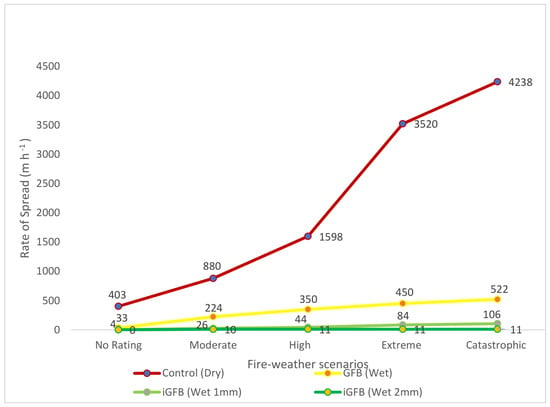
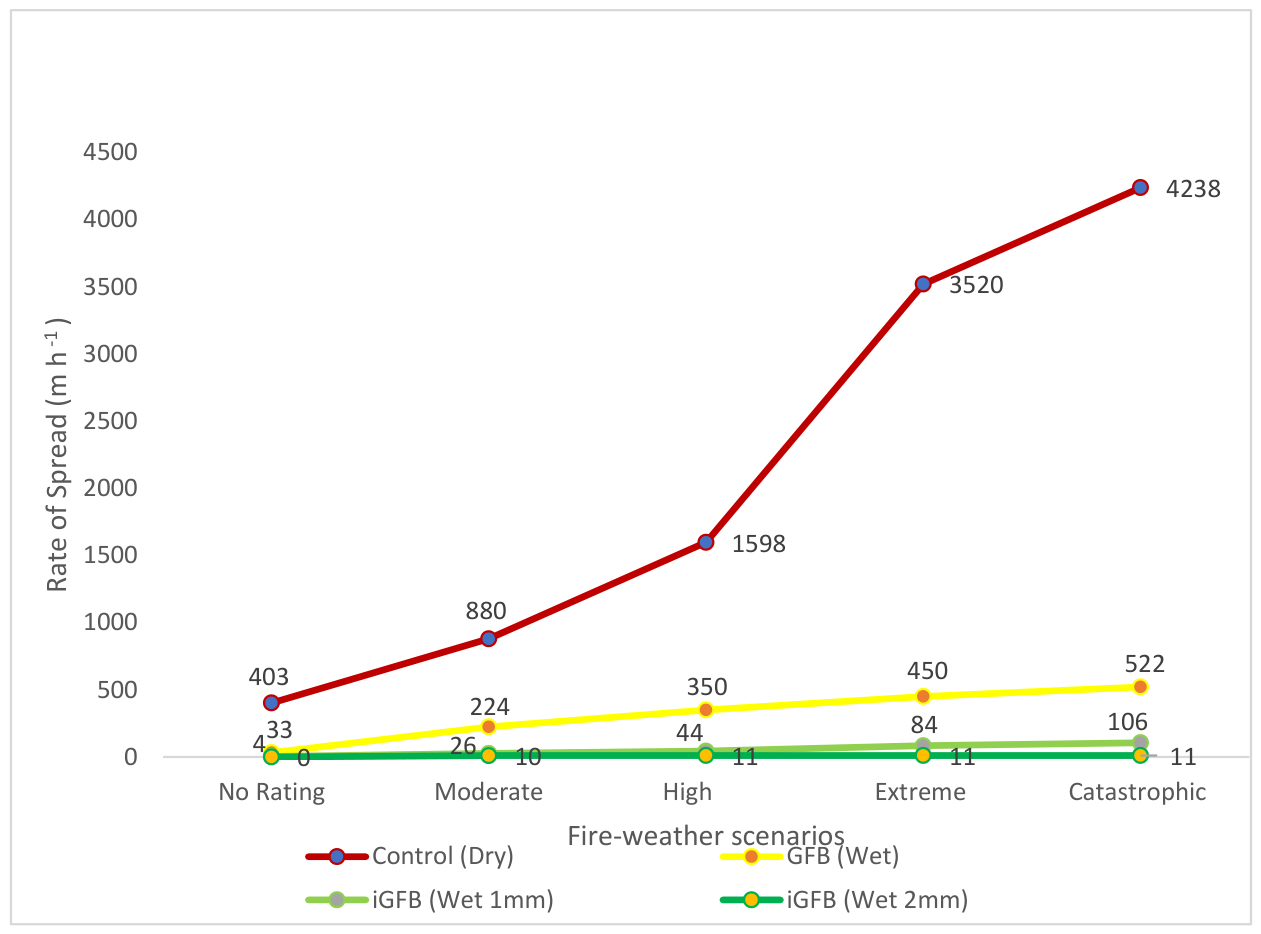
Under moderate fire weather, fires were predicted to spread nearly four times faster in the dry eucalypt control than in the wet eucalypt GFB without irrigation and over 80 times faster than in the iGFB receiving 2 mm day−1 of irrigation (Table 5, Figure 1). The dry eucalypt control entered Phase 2 at lower fire-weather levels and transitioned to Phase 3 under high and more severe fire-weather conditions. Under catastrophic conditions, the predicted spread rate exceeded 4 km h−1, indicating a fast-moving forest fire [28].
Table 5.
Rates of fire spread predicted using AMICUS 0.7.1 beta with Vesta Mk2 vegetation.
Figure 1.
Modelled rates of fire spread across fire-weather scenarios for the control, GFB, and iGFB scenarios. Values were predicted using AMICUS Vesta Mk2 under no rating, moderate, high, extreme, and catastrophic fire-weather conditions. Across all scenarios, the control produced the highest spread rates and the iGFB produced the lowest. Please see Table 5 for more information.
By contrast, all iGFB scenarios remained within the Phase 1 rate-of-spread range across all fire-weather scenarios. Under catastrophic weather conditions, irrigation was associated with substantially lower predicted rates of spread than both the dry eucalypt control and the non-irrigated GFB. Even at only 1 mm m−2 day−1, irrigation was predicted to reduce the fire spread rate substantially.
3.2. Modeled Fireline Intensity
The modeled fireline intensity was highly sensitive to drought (Figure 2). Under catastrophic drought and fire-weather conditions, the peak fireline intensities in the dry eucalypt control exceeded 65,000 kW m−1. The strongest contrast was observed between the dry eucalypt control and the non-irrigated GFB scenario.
Most non-irrigated GFB scenarios and all iGFB scenarios stayed under the threshold. However, under catastrophic conditions, the non-irrigated GFB scenario exceeded this threshold. In contrast, the irrigated scenarios remained below the threshold across the tested fire-weather range.
Figure 2.
Modeled fireline intensities across fire-weather scenarios for the control, GFB, and iGFB scenarios. Values were predicted using AMICUS Vesta Mk2 under no rating, moderate, high, extreme, and catastrophic fire-weather conditions. Across all scenarios, the control produced the highest intensity rates and the iGFB produced the lowest. Please see Table 6 for more information.
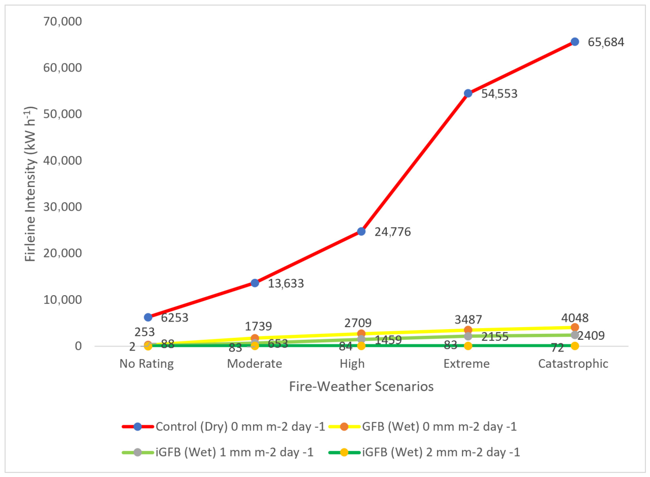
Table 6.
Fireline intensities predicted using AMICUS 0.7.1 beta with Vesta Mk2 vegetation.
3.3. Sensitivity of Model Outputs to Key Input Assumptions
Sensitivity analysis was used to assess how variation in selected input parameters influenced the predicted fire spread rate and fireline intensity in the control and design scenarios. Alterations to the control scenario typically reduced the fire spread rate and fireline intensity, whereas alterations to the iGFB design scenario typically increased both outputs. Despite some variation in magnitude, these changes did not reverse the overall treatment pattern.
For the control scenario, model outputs were most sensitive to drought-related inputs, particularly the shift from extreme to no drought (Figure 3). Fuel moisture and fuel load showed moderate sensitivity. The wind adjustment factor was less sensitive; however, the model already included moderate wind. The vegetation change to wet eucalypt was not sensitive and was flagged in the software as lacking input boundaries.
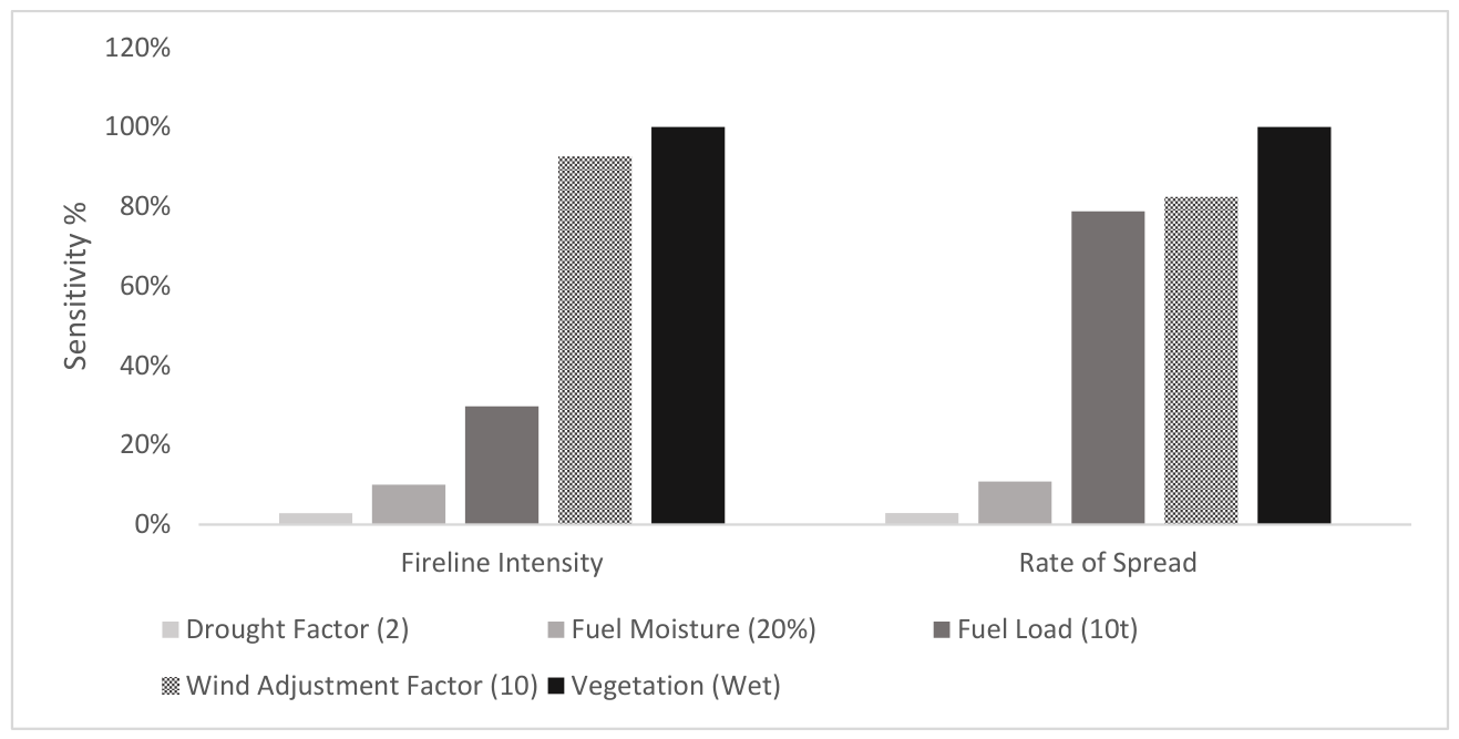
Table 7.
Control sensitivity results—rate of spread.
Table 8.
Control sensitivity results—fireline intensity.
For the iGFB 2 mm design scenario, model outputs were more variable than in the control. The rate of spread was more sensitive to drought and vegetation assumptions, whereas fireline intensity was more sensitive to fuel load and fuel moisture. The wind adjustment factor also had a strong influence on the design scenario outputs; however, the change was significant from the very high to the lowest rate (Figure 4). Overall, the sensitivity analysis indicated that absolute model outputs varied with key assumptions, but the relative advantage of the iGFB scenario was generally maintained across the tested parameter range.
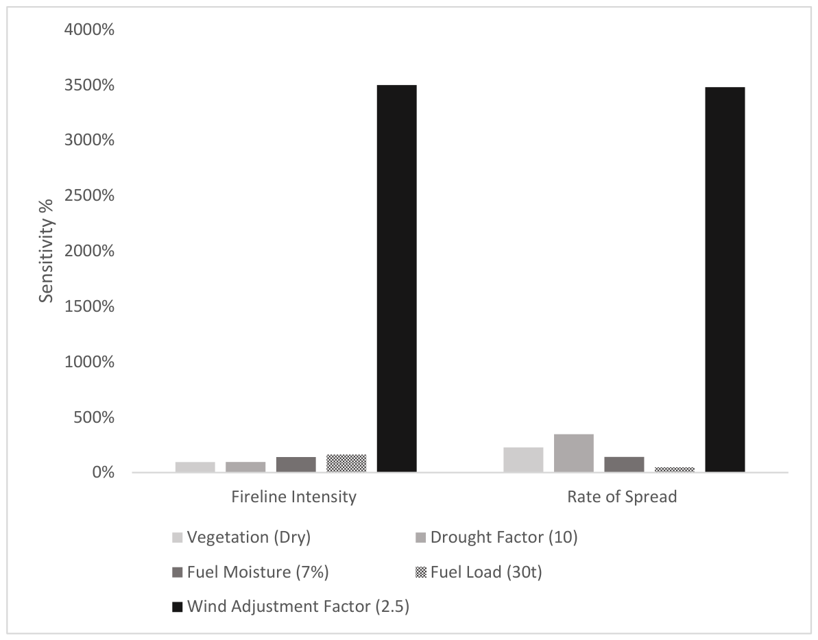
Table 9.
iGFB2 design sensitivity results—rate of spread.
Table 10.
iGFB2 design sensitivity results—fireline intensity.
The sensitivity results support the comparatively lower fire behaviour of the design compared to the control, and the effects on the rate of spread and fireline intensity were more consistent than those of the design. The wind adjustment factor was kept conservative for the control and at the upper level for the design; the sensitivity analysis highlights the importance of this parameter. While this is not quantitative accuracy, it should influence design considerations and further testing for future applications.
4. Discussion
This study used control, GFB, and iGFB scenarios to test whether irrigation could reduce modeled fire spread rate and fireline intensity under increasingly severe fire-weather conditions. Across the tested scenarios, the dry eucalypt control consistently produced the highest predicted rate of spread and fireline intensity, while the irrigated scenarios produced the lowest values. Even if iGFBs are effective at mitigating fire, it is important that households within the interface practice fire-risk reduction by using fire-resistant building materials and removing fuels close to the home, as most homes are lost to embers, although some could still penetrate under extreme conditions.
The control scenarios were intentionally configured to represent severe drought conditions and therefore indicate the types of behavior that may occur when low fuel moisture combines with worsening fire weather. Notably, even in the absence of elevated fire-weather conditions, the control scenarios produced fireline intensities above the indicative suppression threshold. This result reinforces concern about the influence of drought on fire behavior, even before additional fire-weather escalation is considered. In this respect, the results are consistent with research following the Black Summer fires, which identified drought and fire weather as stronger drivers of large fires than fuel alone [75].
The non-irrigated GFB scenario performed better than the dry eucalypt control across the tested fire-weather classes, indicating that vegetation change alone may reduce predicted fire behavior relative to drought-affected dry eucalypt conditions. However, the non-irrigated GFB scenario exceeded the suppression threshold under catastrophic conditions. These findings suggest that the advantages of GFBs without irrigation are most evident under mild-to-moderate fire-weather conditions and are far superior to those of the dry eucalypt control, while also reinforcing concerns that such systems may lose effectiveness as vegetation dries under increasingly extreme conditions [7,8], especially when winds are not buffered.
By contrast, the irrigated scenarios exhibited benefits in fire spread and fireline intensity across all fire-weather scenarios, with greater benefits under more irrigation. Irrigating at 1 mm m−2 day−1 provides the greatest benefits when fire weather is absent; however, all these scenarios remained below Phase 3 and within suppression thresholds, reaching a maximum of 2409 kW m−1 as fire weather became catastrophic. The 2 mm m−2 day−1 scenarios transitioned to Phase 2 only under extreme and catastrophic fire weather, but the peak fireline intensity of 561 kW m−1 remains well within the suppression threshold. These findings suggest that irrigation may strengthen green firebreak function by maintaining lower fire behavior under severe drought and fire-weather conditions. In practical terms, lower spread rates and lower fireline intensities may increase the time available for warning, preparation, evacuation, or suppression.
AMICUS has provided a useful initial testing platform; however, several caveats or limitations are important to note, such as simplified design, proxy vegetation, and software adaptation. While this model provides an initial snapshot, validation would be strengthened through comparison with longer-duration real-fire behavior in dry and wet eucalypt systems; this is especially important as models assume homogeneity of fuels, whereas in practice, site characteristics alter fuels, moisture, and microclimate. Future research would benefit most from validation using empirical field data, where non-irrigated and irrigated plots across diverse locations would enable direct measurements and increase confidence. This research is intended as a justification for field testing.
The AMICUS Vesta Mk2 fire spread model is mathematical, facilitates comparison, and is described as performing better than earlier models [30]; however, errors may overpredict spread rates [10]. While conservative prediction is generally preferable to underestimation in fire management contexts, this uncertainty still affects the interpretation of the absolute values generated by the model. The dry eucalypt control scenarios were classified by AMICUS as having good model quality; the wet eucalypt design scenarios were classified only as fair, which represents parameters just outside design tolerances; they were not classified as ‘poor’, which is well outside the design tolerances [31]. In the AMICUS scenario results, it notes that the wet eucalypt is an adaptation of the dry eucalypt model and, as such, does not have ideal input boundaries. The fair status is not a rejection of the data; it is a conditional flag, noting the need for further research, which is in part why the scenarios have been run [29].
An anomaly was noted in the rate of spread results; at 2 mm m−2 day−1 irrigation, the rate of spread stabilized at moderate and higher fire weather (11 m h−1) and then declined as the fire weather became extreme (10 m h−1) and catastrophic (9 m h−1). Given the small magnitude of this change, it did not alter the overall treatment pattern, but it may reflect a known trend toward reduced model performance at low spread rates or behavior near the limits of the model’s valid operating range [16,28]. This does not invalidate the comparison, but it does indicate lower confidence in the underlying validation of the design-side simulations.
Cross-model comparisons with alternative fire-behavior software would help to identify the consistency, strengths, and weaknesses of modeling approaches. This would be further enhanced through model comparisons with field data to cross-check modeled irrigation effects. Furthermore, sensitivity was measured through one-at-a-time parameter variation, and when comparing model and field data, this could be strengthened through multi-parameter approaches.
Together, these limitations highlight the need for future empirical testing to strengthen the validity of AMICUS; however, as a simplified and illustrative design, this model-based analysis identified the potential effects of vegetation and irrigation on fire behavior in a single case-study WUI landscape in southeast Queensland. The results should therefore be interpreted as conceptual rather than prescriptive but do justify the need for further empirical testing of the iGFB approach.
The sensitivity analysis reinforced consideration of drought and fire weather, as the AMICUS model is driven more by environmental factors such as moisture, wind, and vegetation than by fuel load. Although vegetation is a less dynamic variable, the model shows that changes in moisture and wind can dramatically alter fire behavior. At the same time, the sensitivity analysis suggested that although absolute values varied with parameter changes, the overall advantage of the iGFB scenarios was generally maintained across the tested range. This strengthens the interpretation that the effect of irrigation in the model was not solely an artefact of a single parameter setting.
More broadly, the present findings highlight both the usefulness and the limits of existing fire-behavior models when applied to novel, water-based mitigation concepts. The iGFB design intentionally manipulates vegetation and moisture, but these variables are not parameterized for this purpose within AMICUS, and the design scenarios rely on less-validated wet eucalypt proxy inputs. Further work is therefore needed to test whether the same patterns emerge under alternative modeling frameworks, broader parameter sets, and, ultimately, field-based investigation.
AMICUS provides a snapshot of the initial fire behavior rather than the full temporal complexity of a long-duration wildfire. The persistence and cascading nature of major wildfire events mean that the longer-term performance of irrigated green firebreaks cannot be inferred from the present modeling exercise alone [76,77]. Further research is therefore warranted on the feasibility, implementation, and trade-offs of irrigated green firebreaks, including issues such as vegetation selection, irrigation design, water sourcing, and longer-term system performance under real-world WUI conditions.
5. Conclusions
This study used a simplified modeling framework to provide preliminary consideration of how vegetation type and irrigation influenced predicted fire spread and fireline intensity in a wildland-urban interface (WUI) case study in Noosa, southeast Queensland, Australia. The results of this research showed that the control produced the highest fire behavior, as seen through fire spread rates and fireline intensity, while the iGFB design produced the lowest, supporting irrigation as a potential tool to strengthen GFBs.
More research is required to validate this preliminary and illustrative proof-of-concept, as it is based on a single modeling framework (AMICUS), has a simplified design (parameters), and uses adapted inputs (proxy vegetation and irrigation). The results support the iGFB concept, but caution is needed, and empirical validation through field data is required, especially regarding wind considerations.
These findings are important in a climate change context, as they suggest that irrigation may reduce fire behavior under increasingly severe fire-weather conditions. The sensitivity analysis confirmed the relative potential advantage of the iGFB design under these parameters. In this way, iGFBs may complement fire management in the WUI, especially compared to non-irrigated vegetation.
The iGFB approach should not be considered a stand-alone solution suitable for all settings or capable of stopping all fires; rather, it should be viewed as having site-specific potential within broader integrated fire management strategies. The iGFB design could have multiple values and will ultimately be dictated by the desired purpose and site characteristics; however, this research illustrates potential to complement existing fire management.
The principal contribution of this paper is the testing of irrigated green firebreaks as a proactive fire-mitigation concept within a region-specific modeling framework that is responsive to climatic heating and drying trends. On that basis, this study supports the case for further applied research to assess the feasibility, performance, and limitations of iGFBs under real-world conditions.
Author Contributions
Conceptualization, methodology, validation, investigation, resources, data curation, and original draft preparation, J.D.S.; writing—review and editing, visualization, supervision, and project administration, J.D.S., A.P., F.E.P., and S.V.H. All authors have read and agreed to the published version of the manuscript.
Funding
This research received no external funding. The lead author’s PhD studies were supported by scholarships from the University of the Sunshine Coast and Natural Hazards Research Australia.
Data Availability Statement
The data supporting reported results can be found in the main article. For replication, this data was processed with AMICUS v0.7.1 beta platform with Vesta MK2.
Acknowledgments
We acknowledge the past, present, and emerging traditional owners’ management of Country, as well as the important traditional approaches and scientific research that we seek to build upon. We also extend our gratitude to our research colleagues and peers for their ongoing support.
Conflicts of Interest
Author Anthony Power was employed by the company Covey Associates (Cedaryn Prop. Ltd.). The remaining authors declare that the research was conducted in the absence of any commercial or financial relationships that could be construed as a potential conflict of interest.
References
- Nolan, R.H.; Bowman, D.M.J.S.; Clarke, H.; Haynes, K.; Ooi, M.K.J.; Price, O.F.; Williamson, G.J.; Whittaker, J.; Bedward, M.; Boer, M.M.; et al. What Do the Australian Black Summer Fires Signify for the Global Fire Crisis? Fire 2021, 4, 97. [Google Scholar] [CrossRef] [Scilit]
- Teymoor Seydi, S.; Abatzoglou, J.T.; Jones, M.W.; Kolden, C.A.; Filippelli, G.; Hurteau, M.D.; AghaKouchak, A.; Luce, C.H.; Miao, C.; Sadegh, M. Increasing global human exposure to wildland fires despite declining burned area. Science 2025, 389, 826–829. [Google Scholar] [CrossRef] [Scilit] [PubMed]
- Ellis, T.M.; Bowman, D.M.J.S.; Jain, P.; Flannigan, M.D.; Williamson, G.J. Global increase in wildfire risk due to climate-driven declines in fuel moisture. Glob. Change Biol. 2022, 28, 1544–1559. [Google Scholar] [CrossRef] [Scilit] [PubMed]
- Tolhurst, K. Submission to the Inquiry into the Impact of Public Land Management Practices on Bushfires in Victoria; Environment and Natural Resources Committee: Victoria, Australia, 2007.
- Owens, D.; O’Kane, M. Final Report of the NSW Bushfire Inquiry; New South Wales Government: Sydney, Australia, 2020; p. 436.
- Productivity Commission. Natural Disaster Funding Arrangements: Productivity Commission Inquiry Report; 9781740375252; Australian Productivity Commission: Canberra, Australia, 2015.
- Cui, X.; Alam, M.A.; Perry, G.L.; Paterson, A.M.; Wyse, S.V.; Curran, T.J. Green firebreaks as a management tool for wildfires: Lessons from China. J. Environ. Manag. 2019, 233, 329–336. [Google Scholar] [CrossRef] [Scilit] [PubMed]
- Smith, J.D.; Putz, F.E.; Van Holsbeeck, S. Green Firebreaks: Potential to Proactively Complement Wildfire Management. Fire 2025, 8, 352. [Google Scholar] [CrossRef] [Scilit]
- Zong, X.; Wang, X.; Coogan, S.C.P.; Flannigan, M.D. Effectiveness of firebreaks: A review. Fire Ecol. 2026, 22, 17. [Google Scholar] [CrossRef] [Scilit]
- Oliveira, A.S.; Silva, J.S.; Guiomar, N.; Fernandes, P.; Nereu, M.; Gaspar, J.; Lopes, R.F.R.; Rodrigues, J.P.C. The effect of broadleaf forests in wildfire mitigation in the WUI—A simulation study. Int. J. Disaster Risk Reduct. 2023, 93, 103788. [Google Scholar] [CrossRef] [Scilit]
- Wang, H.H.; Finney, M.A.; Song, Z.L.; Wang, Z.S.; Li, X.C. Ecological techniques for wildfire mitigation: Two distinct fuelbreak approaches and their fusion. For. Ecol. Manag. 2021, 495, 119376. [Google Scholar] [CrossRef] [Scilit]
- Marshall, E.; Parkins, K.; Raulings, E.; Ababei, D.; Kultaev, D.; Penman, T.D. Are green firebreaks a useful fire management tool under climate change in southeastern Australia? Sci. Total Environ. 2026, 1016, 181459. [Google Scholar] [CrossRef] [Scilit] [PubMed]
- Marshall, E.; Holyland, B.; Parkins, K.; Raulings, E.; Good, M.K.; Swan, M.; Bennett, L.T.; Penman, T.D. Can green firebreaks help balance biodiversity, carbon storage and wildfire risk? J. Environ. Manag. 2024, 369, 122183. [Google Scholar] [CrossRef] [Scilit] [PubMed]
- Fairfax, E.; Whipple, A.; Wheaton, J.M.; Osorio, B.; Miller, J.; Kirksey, K.; Perez, N.; Gilbert, J.T.; Jordan, C.E. Impacts of beaver dams on riverscape burn severity during megafires in the Rocky Mountain region, western United States. In Biogeomorphic Responses to Wildfire in Fluvial Ecosystems; Geological Society of America: Boulder, CO, USA, 2024. [Google Scholar] [CrossRef] [Scilit]
- Plucinski, M.P.; Sullivan, A.L.; Rucinski, C.J.; Prakash, M. Improving the reliability and utility of operational bushfire behaviour predictions in Australian vegetation. Environ. Model. Softw. 2017, 91, 1–12. [Google Scholar] [CrossRef] [Scilit]
- Cruz, M.G.; Cheney, N.P.; Gould, J.S.; McCaw, W.L.; Kilinc, M.; Sullivan, A.L. An empirical-based model for predicting the forward spread rate of wildfires in eucalypt forests. Int. J. Wildland Fire 2021, 31, 81–95. [Google Scholar] [CrossRef] [Scilit]
- Cruz, M.G. The Vesta Mk 2 Rate of Fire Spread Model—A User’s Guide; CSIRO: Canberra, Australia, 2021; p. 76.
- Commonwealth Scientific and Industrial Research Organisation. State of the Climate 2024; Commonwealth Scientific and Industrial Research Organisation: Canberra, Australia, 2024; ISBN 978-1-4863-2124-7.
- Bureau of Meteorology. Severe Fire Weather Conditions in Southeast Queensland and Northeast New South Wales in September 2019; Bureau of Meteorology: Melbourne, Australia, 2019.
- Summary Statistics: Sunshine Coast Airport. Available online: https://www.bom.gov.au/climate/averages/tables/cw_040861.shtml (accessed on 4 June 2025).
- Australian Bureau of Statistics. Noosa Shire Council Community Profile; Australian Bureau of Statistics—Informed Decisions id: Canberra, Australia, 2024. [Google Scholar]
- Queensland Government. Noosa Area Management Plan; Queensland Government: Brisbane, Australia, 2022.
- CSIRO. NBIC Update; CSIRO: Canberra, Australia, 2025.
- Meiklejohn, A.M.; Olds, J.A.; Laidlaw, M.J.; Levy, S.; Midtaune, K.; Lawton, C. Post-Fire Assessment Report—Natural Values: 2019 Bushfire, Great Sandy and Noosa National Parks, South East Queensland Bioregion; Department of the Environment and Science, Queensland Government: Brisbane, Australia, 2020.
- Noosa Council. Environmental Sensors to Improve Bushfire Prediction Capabilities (Noosa); Noosa Council: Noosa, Australia, 2021.
- Little, K.; Graham, L.J.; Flannigan, M.; Belcher, C.M.; Kettridge, N. Landscape controls on fuel moisture variability in fire-prone heathland and peatland landscapes. Fire Ecol. 2024, 20, 14. [Google Scholar] [CrossRef] [Scilit]
- Styger, J. Predicting Fire in Rainforest. Bachelor’s Thesis, University of Tasmania, Hobart, Australia, 2014. [Google Scholar]
- Gale, M.G.; Cary, G.J. Evaluating Australian forest fire rate of spread models using VIIRS satellite observations. Environ. Model. Softw. 2025, 188, 106436. [Google Scholar] [CrossRef] [Scilit]
- CSIRO. AMICUS A New Tool for Fire Spread Prediction; CSIRO: Canberra, Australia, 2015.
- Sullivan, A.; Gould, J.; Cruz, M.; Rucinski, C.; Prakash, M. Amicus: A national fire behaviour knowledge base for enhanced information management and better decision making. In Proceedings of the 20th International Congress on Modelling and Simulation, Adelaide, Australia, 1–6 December 2013. [Google Scholar]
- Commonwealth Scientific and Industrial Research Organisation. Amicus Version 0.7 Beta Users’ Guide; Commonwealth Scientific and Industrial Research Organisation: Canberra, Australia, 2021; p. 37.
- Gould, J.; McCaw, W.; Cheney, N.; Ellis, P.; Knight, I.; Sullivan, A. Project Vesta: Fire in Dry Eucalypt Forest: Fuel Structure, Fuel Dynamics and Fire Behaviour; CSIRO Publishing: Canberra, Australia, 2008. [Google Scholar]
- Hines, H.B.; Laidlaw, M.J.; Buch, W.; Olyott, L.; Levy, S.; Melzer, R.; Meiklejohn, A. Post-fire Assessment Report—Natural Values: 2019 Bushfire, Lamington National Park, South East Queensland Region; Department of Environment and Science, Queensland Government: Brisbane, Australia, 2020.
- QFES. Bushfire Resilient Communities: Technical Reference Guide for the State Planning Policy State Interest ‘Natural Hazards, Risk and Resilience—Bushfire’; QFES: Albion, Australia, 2019.
- Summers, P. Bushfire Hazard Planning in Noosa Shire—A Planning Scheme Review Project; Noosa Council: Noosa, Australia, 1995.
- Noosa Shire Topographic Map, Elevation, Terrain. Available online: https://en-gb.topographic-map.com/map-4c3nnh/Noosa-Shire/ (accessed on 1 June 2026).
- Tng, D.Y.P. Are Giant Eucalypt Forests Rain Forest? Ph.D. Thesis, University of Tasmania, Hobart, Australia, 2014. [Google Scholar]
- Wilf, P.; Kooyman, R.M. Paleobotany reframes the fiery debate on Australia’s rainforest edges. New Phytol. 2025, 245, 1355–1365. [Google Scholar] [CrossRef] [Scilit] [PubMed]
- Li, Y.; Liu, B.; Veraverbeke, S.; Janssen, T.A.J.; He, B. A review of multi-category forest fuel load estimation methods from traditional measurements to remote sensing and future perspectives: Towards fire prevention. Remote Sens. Environ. 2026, 343, 115508. [Google Scholar] [CrossRef] [Scilit]
- Gould, J.S.; Lachlan McCaw, W.; Phillip Cheney, N. Quantifying fine fuel dynamics and structure in dry eucalypt forest (Eucalyptus marginata) in Western Australia for fire management. For. Ecol. Manag. 2011, 262, 531–546. [Google Scholar] [CrossRef] [Scilit]
- Cheney, N.P.; Gould, J.S.; McCaw, W.L.; Anderson, W.R. Predicting fire behaviour in dry eucalypt forest in southern Australia. For. Ecol. Manag. 2012, 280, 120–131. [Google Scholar] [CrossRef] [Scilit]
- Nguyen, T.H.; Jones, S.; Reinke, K.J.; Soto-Berelov, M. Estimating fine fuel loads in Eucalypt forests using forest inventory data and a modelling approach. For. Ecol. Manag. 2024, 561, 121851. [Google Scholar] [CrossRef] [Scilit]
- Hines, F.; Tolhurst, K.G.; Wilson, A.A.; Mccarthy, G.J. Overall Fuel Hazard Assessment Guide Fire and Adaptive Management; 978-1-74242-677-8; Department of Sustainability and Environment: Melbourne, Australia, 2010.
- Horsey, B.; Watson, P. Bark Fuel in New South Wales Forests and Grassy Woodlands; University of Wollongong: Wollongong, Australia, 2012. [Google Scholar]
- Pickering, B.J.; Bennett, L.T.; Cawson, J.G. Extending methods for assessing fuel hazard in temperate Australia to enhance data quality and consistency. Int. J. Wildland Fire 2023, 32, 1422–1437. [Google Scholar] [CrossRef] [Scilit]
- Cruz, M.G. A comment on the use of visually assessed fuel hazard ratings and scores for Australian fire management and research. Int. J. Wildland Fire 2024, 33, WF23164. [Google Scholar] [CrossRef] [Scilit]
- Wang, S.S.-C.; Leung, L.R.; Qian, Y. The Role of Wind Speed in Prolonging Large Fire Durations in the Western US. Geophys. Res. Lett. 2025, 52, e2024GL112539. [Google Scholar] [CrossRef] [Scilit]
- Hung, W.-T.; Campbell, P.C.; Moon, Z.; Saylor, R.; Kochendorfer, J.; Lee, T.R.; Massman, W. Evaluation of an in-canopy wind and wind adjustment factor model for wildfire spread applications across scales. J. Adv. Model. Earth Syst. 2024, 16, e2024MS004300. [Google Scholar] [CrossRef] [Scilit]
- Ma, Z.; Gris, D.; do Nascimento, P.d.J.F.P.; de Castilho, C.V.; Ribeiro, S.C.; Tapajós, R.; Machado, W.; Júnior, M.A.; Camargo, J.L.; Chaves e Carvalho, S.d.P.; et al. The variability of microclimate in the Amazon Rainforest. Agric. For. Meteorol. 2025, 375, 110866. [Google Scholar] [CrossRef] [Scilit]
- Moon, K.; Duff, T.; Tolhurst, K. Sub-canopy forest winds: Understanding wind profiles for fire behaviour simulation. Fire Saf. J. 2019, 105, 320–329. [Google Scholar] [CrossRef] [Scilit]
- Sutherland, D.; Rashid, M.A.; Hilton, J.E.; Moinuddin, K.A.M. Implementation of spatially-varying wind adjustment factor for wildfire simulations. Environ. Model. Softw. 2023, 163, 105660. [Google Scholar] [CrossRef] [Scilit]
- Rashid, M.; Hilton, J.; Khan, N.; Sutherland, D.; Moinuddin, K. A Report on WRF Software Development (Preliminary); Bushfire Natural Hazards CRC: Melbourne, Australia, 2020. [Google Scholar]
- Penman, T.D.; Collins, L.; Price, O.F.; Bradstock, R.A.; Metcalf, S.; Chong, D.M.O. Examining the relative effects of fire weather, suppression and fuel treatment on fire behaviour—A simulation study. J. Environ. Manag. 2013, 131, 325–333. [Google Scholar] [CrossRef] [Scilit] [PubMed]
- Fernandez-Guisuraga, J.M.; Calvo, L. Fire severity shows limited dependence on fuel structure under adverse fire weather conditions: A case study of two extreme wildfire events. Fire Ecol. 2025, 21, 28. [Google Scholar] [CrossRef] [Scilit]
- Matthews, S.; Gould, J.; McCaw, L. Simple models for predicting dead fuel moisture in eucalyptus forests. Int. J. Wildland Fire 2010, 19, 459–467. [Google Scholar] [CrossRef] [Scilit]
- Gordon, C.E.; Boer, M.M.; Griebel, A.; Yebra, M.; Sturgess, A.; Collins, L.; Nolan, R.H. Fuel moisture moderates wildfire resistance in rainforests of south-east Australia. Environ. Res. Commun. 2025, 7, 081006. [Google Scholar] [CrossRef] [Scilit]
- Cawson, J.G.; Duff, T.J.; Swan, M.H.; Penman, T.D. Wildfire in wet sclerophyll forests: The interplay between disturbances and fuel dynamics. Ecosphere 2018, 9, e02211. [Google Scholar] [CrossRef] [Scilit]
- Bradstock, R.A. A biogeographic model of fire regimes in Australia: Current and future implications. Glob. Ecol. Biogeogr. 2010, 19, 145–158. [Google Scholar] [CrossRef] [Scilit]
- Ellis, P. The likelihood of ignition of dry-eucalypt forest litter by firebrands. Int. J. Wildland Fire 2015, 24, 225–235. [Google Scholar] [CrossRef] [Scilit]
- CSIRO. The Dry Eucalypt Forest Fire Model; CSIRO: Canberra, Australia, 2015.
- Pickering, B.J.; Duff, T.J.; Baillie, C.; Cawson, J.G. Darker, cooler, wetter: Forest understories influence surface fuel moisture. Agric. For. Meteorol. 2021, 300, 108311. [Google Scholar] [CrossRef] [Scilit]
- Sneeuwjagt, R.J.; Peet, G.B. Forest Fire Behaviour Tables for Western Australia; Department of Conservation and Land Management: Perth, Australia, 1985.
- Assouline, S. A Simple Method to Design Irrigation Rate and Duration and Improve Water Use Efficiency. Water Resour. Res. 2019, 7, 0043–1397. [Google Scholar] [CrossRef] [Scilit]
- Department of Natural Resources, Mines and Energy. Efficient Irrigation for Water Conservation: Guideline for Water Efficient Urban Gardens and Landscapes; Department of Natural Resources, Mines and Energy: Brisbane, Australia, 2020.
- Cui, J.; Wang, Q.; Liu, K.; Zhai, J.; Zhao, Y. Mechanisms by which irrigation regimes influence soil water deep percolation. Agric. Water Manag. 2025, 321, 109905. [Google Scholar] [CrossRef] [Scilit]
- Holden, Z.; Swanson, A.; Sadegh, M.; Luce, C.; Noonan-Wright, E.; Parsons, R. Soil Moisture is a Stronger Predictor of Forest Fire Spread Potential Than Weather in the U.S. Northern Rocky Mountains. Geophys. Res. Lett. 2025, 52, e2025GL116248. [Google Scholar] [CrossRef] [Scilit]
- Zhao, L.; Yebra, M.; van Dijk, A.; Cary, G.; Matthews, S.; Sheridan, G. The influence of soil moisture on surface and sub-surface litter fuel moisture simulation at five Australian sites. Agric. For. Meteorol. 2021, 298–299, 108282. [Google Scholar] [CrossRef] [Scilit]
- Krueger, E.S.; Levi, M.R.; Achieng, K.O.; Bolten, J.D.; Carlson, J.D.; Coops, N.C.; Holden, Z.A.; Magi, B.I.; Rigden, A.J.; Ochsner, T.E. Using soil moisture information to better understand and predict wildfire danger: A review of recent developments and outstanding questions. Int. J. Wildland Fire 2022, 32, 111–132. [Google Scholar] [CrossRef] [Scilit]
- Keetch, J.J.; Byram, G.M. A Drought Index for Forest Fire Control; US Department of Agriculture, Forest Service, Southeastern Forest Experiment Station: Asheville, NC, USA, 1968; Volume 38.
- Li, Y.; Campbell, E.P.; Haswell, D.; Sneeuwjagt, R.J.; Venables, W.N. Statistical forecasting of soil dryness index in the southwest of Western Australia. For. Ecol. Manag. 2003, 183, 147–157. [Google Scholar] [CrossRef] [Scilit]
- Veysi, S.; Nouri, M. Spatiotemporal dynamics of single and compound drought–heatwave extremes impacts on water productivity. J. Hydrol. Reg. Stud. 2026, 65, 103370. [Google Scholar] [CrossRef] [Scilit]
- Griffiths, D. Improved Formula for the Drought Factor in McArthur’s Forest Fire Danger Meter. Aust. For. 1999, 62, 202–206. [Google Scholar] [CrossRef] [Scilit]
- Finkele, K.; Mills, G.A.; Beard, G.; Jones, D.A. National gridded drought factors and comparison of two soil moisture deficit formulations used in prediction of Forest Fire Danger Index in Australia. Aust. Meteorol. Mag. 2006, 55, 183–197. [Google Scholar] [CrossRef] [Scilit]
- Jolly, W. Sensitivity of a surface fire spread model and associated fire behaviour fuel models to changes in live fuel moisture. Int. J. Wildland Fire 2007, 16, 503–509. [Google Scholar] [CrossRef] [Scilit]
- Nolan, R.H.; Boer, M.M.; Collins, L.; Resco de Dios, V.; Clarke, H.; Jenkins, M.; Kenny, B.; Bradstock, R.A. Causes and consequences of eastern Australia’s 2019–20 season of mega-fires. Glob. Change Biol. 2020, 26, 1039–1041. [Google Scholar] [CrossRef] [Scilit] [PubMed]
- Kemter, M.; Fischer, M.; Luna, L.V.; Schönfeldt, E.; Vogel, J.; Banerjee, A.; Korup, O.; Thonicke, K. Cascading Hazards in the Aftermath of Australia’s 2019/2020 Black Summer Wildfires. Earth’s Future 2021, 9, e2020EF001884. [Google Scholar] [CrossRef] [Scilit]
- Hamilton, M.; Salerno, J.; Fischer, A. Cognition of complexity and trade-offs in a wildfire-prone social-ecological system. Environ. Res. Lett. 2019, 14, 125017. [Google Scholar] [CrossRef] [Scilit]

Disclaimer/Publisher’s Note: The statements, opinions and data contained in all publications are solely those of the individual author(s) and contributor(s) and not of MDPI and/or the editor(s). MDPI and/or the editor(s) disclaim responsibility for any injury to people or property resulting from any ideas, methods, instructions or products referred to in the content. |
© 2026 by the authors. Licensee MDPI, Basel, Switzerland. This article is an open access article distributed under the terms and conditions of the Creative Commons Attribution (CC BY) license.